INTELLIGENT DECISION SUPPORT SYSTEM TO
OPTIMIZE, MANAGE AND PLAN WATER QUALITY
MONITORING PROGRAMS BASED ON A
PARTICIPATIVE APPROACH
Thèse
Sonja Behmel
Doctorat en aménagement du territoire et développement régional
Philosophiae doctor (Ph.D.)
Québec, Canada
INTELLIGENT DECISION SUPPORT SYSTEM TO
OPTIMIZE, MANAGE AND PLAN WATER QUALITY
MONITORING PROGRAMS BASED ON A
PARTICIPATIVE APPROACH
Thèse
Sonja Behmel
Sous la direction de :
Manuel Rodriguez, directeur de recherche
Ralf Ludwig, codirecteur de recherche
Résumé
Cette thèse s’intéresse au développement d’un système intelligent d’aide à la décision (SIAD) destiné à la conception, à la gestion et à l’optimisation des programmes de suivi de la qualité de l’eau (PSQE). Toute son originalité repose sur le fait qu’elle aborde la question dans une perspective holistique qui se traduit par le développement d’une approche participative dans le but de déterminer les besoins en connaissances sur la qualité et la quantité de l’eau sur lesquels se base le SIAD pour assister les gestionnaires de PSQE à toutes les étapes de la planification, de la gestion et de l’optimisation d’un PSQE.
Ce système s’adresse aux organisations responsables de PSQE ainsi qu’aux divers utilisateurs qui, au sein de ces organisations, ont besoin d’outils d’aide à la décision adéquats pour les appuyer dans tous les aspects de leur travail. De plus, le SIAD est conçu pour documenter tout type de décision prise durant les étapes de conception, de gestion et d’optimisation du programme afin de découvrir précisément quand, pourquoi et comment des modifications sont apportées. Par ailleurs, cette thèse propose d’élaborer une approche participative afin de cerner les préoccupations de tous les intervenants d’un bassin versant, tant les organisations que les citoyens, par rapport à la qualité de l’eau. L’objectif de l’approche participative consiste à déterminer les besoins en matière de connaissances ainsi que les préoccupations liées à la qualité de l’eau afin d’aider les gestionnaires de PSQE à définir les priorités en ce qui concerne l’acquisition de connaissances. Tant le SIAD que l’approche participative ont été mis à l’épreuve dans le cadre d’études de cas réalisées dans deux bassins versants de la province du Québec, au Canada (le bassin versant de la rivière du Nord et celui de la rivière Saint-Charles).
La première partie de cette thèse porte sur une revue critique de la littérature existante qui traite de tous les aspects du suivi de la qualité de l’eau. Les lignes directrices, les manuels, les politiques et les méthodes proposées dans la littérature scientifique sont ainsi analysés en fonction de leur potentiel à aider les gestionnaires de PSQE et leurs équipes à prendre des décisions éclairées quant à la conception, à la gestion et à l’optimisation des PSQE.
En deuxième partie de thèse sont présentées la méthodologie et la mise en œuvre de l’approche participative, laquelle est conçue pour définir de nouveaux objectifs de suivi et d’optimisation pour les PSQE, ainsi que pour déterminer les moyens de communication à privilégier lorsqu’il est question de l’eau.
La troisième partie de la thèse expose la méthodologie liée à la conception du SIAD, dont le modèle conceptuel, qui est décrit en langage de modélisation unifié, est basé sur une collecte d’informations recueillies au moyen d’une recension des écrits, d’entrevues menées auprès de 44 experts issus de six pays
qui jouissent d’une renommée internationale en matière de qualité de l’eau, de rencontres avec des spécialistes des technologies de l’information, ainsi que d’ateliers avec de potentiels utilisateurs finaux. La séquence des opérations effectuées par le système (cas d’utilisation) ainsi que les livrables qui y sont liés (scénarios, bibliothèques, arbres décisionnels, etc.) sont décrits selon les concepts de méthode agile et de cas d’utilisation 2.0.
En quatrième partie de thèse, les fonctions d’optimisation du SIAD ont été mises à l’épreuve sur des données qui proviennent de deux études de cas (données de lac et données de rivière, respectivement), ainsi que sur un échantillon d’objectifs d’optimisation issus de l’approche participative. Voici certains des éléments du SIAD qui ont été testés : aide à la décision au cours des étapes relatives à (1) la compréhension des raisons qui justifient l’existence des PSQE actuels, à (2) la validation et à l’intégration des données (contrôle de la qualité et stockage), au (3) choix du processus d’optimisation parmi ceux proposés par la littérature, ainsi qu’à (4) la mise en œuvre et au (5) parachèvement du processus d’optimisation.
Abstract
This thesis focuses on the development of an intelligent decision-support system (IDSS) to plan, manage and optimize water quality monitoring programs (WQMPs). The main originality of this thesis is to have approached the question of planning, managing and optimizing WQMPs in a holistic manner. The holistic approach transcends into the developing of a participative approach to identify knowledge needs on water quality and quantity to feed an IDSS which assists WQMP managers in every aspect of planning, managing and optimizing WQMPs.
The system is directed at organizations in charge of WQMPs and a variety of users within these organizations who need adequate decision support for every aspect of their work. In addition, the IDSS is designed to document any type of decision during the planning, management and optimization phases in order to obtain a clear idea of when, why and how changes are made. This thesis also proposes the development of a participative approach to identify all concerns raised by stakeholders in a watershed—both organizations and citizens—regarding water quality. The purpose of the participative approach is to elicit knowledge needs and concerns regarding water quality in order to direct WQMP managers towards priorities in knowledge acquisition. Both the IDSS and the participative approach were tested in two watershed case studies in the province of Quebec, Canada (the Rivière du Nord watershed and the Rivière Saint-Charles watershed). The first component of the thesis consists of a critical review of the literature regarding all aspects of water quality monitoring. Existing guidelines, handbooks, policies and methods proposed in the scientific literature are analyzed to determine their capacity to provide decision support to managers and their teams to plan, manage and optimize WQMPs.
The second component proposes the methodology and application of the participative approach. The participative approach is designed to yield new monitoring objectives and optimization objectives for WQMPs. It is also designed to determine preferred modes of communication on water-related issues.
The third component of the thesis presents the design methodology of the IDSS. The conceptual model of the IDSS is based on an information collection methodology consisting in a literature review, a series of interviews conducted with 44 international water quality experts from six countries, meetings with information technology specialists and workshops with potential end-users. The conceptual model is described in the Unified Modeling Language. The sequence of operations performed by the system (use cases) and related deliverables (use-case scenarios, libraries, decision-support trees, etc.) are described according to the concepts of agile development and Use Case 2.0.
The fourth component of the thesis tests the optimization features of the IDSS based on the data from the two case studies (respectively lake data and river data) and a selection of optimization objectives resulting from the participative approach. Some of the tested elements of the IDSS are: decision support in the steps of (1) understanding the underlying rationale of the existing WQMPs; (2) data validation and integration (quality assessment and storage); (3) selecting optimization procedures proposed in the literature; 4) applying the optimization procedures and (5) finalizing the optimization procedure.
Table of contents
Résumé ... iii
Abstract ... v
Table of contents ... vii
List of tables ... xi
List of figures ... xii
Abbreviations ... 1
Remerciements... 2
GENERAL INTRODUCTION ... 5
I. Brief history of water resource management and knowledge acquisition processes and methods ... 5
II. What is Modern Integrated Water Resource Management? ... 9
III. Hypothesis and objectives ... 12
IV. Thesis methodology in brief ... 14
V. Authors’ contribution to the papers ... 15
1. CHAPTER 1: Water quality monitoring strategies - a review and future perspectives ... 17
Stratégies de suivi de la qualité de l’eau – revue de la littérature et perspectives d’avenir ... 17
1.1. Introduction... 19
1.2. Methodology ... 22
1.2.1. Selection Criteria for the Literature Consulted ... 22
1.2.2. Identification of Use Cases ... 22
1.2.3. Analyze approaches for planning and optimizing water quality monitoring programs ... 23
1.3. Results ... 24
1.3.1. Identification of the use cases ... 24
1.3.2. Approaches Addressing the Planning or Optimizing of a WQMP ... 35
1.3.3. Degree of Transferability of Existing Approaches ... 43
1.4. Discussion and future perspectives ... 49
1.4.1. Discussion ... 49
1.4.2. Future Perspectives ... 51
1.5. Conclusions ... 54
1.6. References ... 55
Transition between chapter 1 and chapter 2... 63
2. CHAPTER 2: Participative approach to elicit water quality monitoring needs from stakeholder groups – an Application of Integrated Watershed Management ... 64
Approche participative visant à connaître les besoins de groupes d’intervenants en matière de suivi de la
qualité de l’eau – une application de la gestion par bassin versant ... 64
2.1. Introduction... 66
2.2. Methodology ... 67
2.2.1. Project-based definition of participation and the participants ... 68
2.2.2. Case studies ... 69
2.2.3. Stakeholder analysis ... 71
2.2.4. Online survey and public participation geographical information system ... 72
2.2.5. Workshops ... 72
2.2.6. Information analysis ... 73
2.2.6.1. Analysis of the survey and PPGIS ... 73
2.2.6.2. Analysis of the workshops ... 75
2.3. Results and discussion ... 75
2.3.1. Stakeholder analysis ... 75
2.3.2. Results of the survey and PPGIS... 77
2.3.2.1. Communication preferences of the citizens and ROS of W1 and W2 ... 77
2.3.2.2. Concerns of the respondents representing the citizens from both watersheds ... 80
2.3.2.3. Concerns of ROS of both watersheds ... 83
2.3.2.4. Results of the PPGIS... 85
2.4. Conclusions ... 92
2.5. Acknowledgements ... 94
2.6. References ... 94
Transition between chapter 2 and chapter 3... 98
3. CHAPTER 3: Intelligent decision-support system to plan, manage and optimize water quality monitoring programs: design of a conceptual framework ... 99
Système intelligent d’aide à la décision destiné à la conception, à la gestion et à l’optimisation des programmes de suivi de la qualité de l’eau : élaboration d’un cadre conceptuel ... 99
3.1. Introduction... 101
3.2. Methodology ... 103
3.2.1. Appropriateness of the subject domain and project context for the proposed IDSS ... 104
3.2.2. Conceptual framework design process ... 104
3.2.2.1. Selection of the system architect, IT specialists, subject domain experts and end users .... 105
3.2.2.2. Interaction with the IT specialists, subject domain experts and end users ... 107
3.2.2.2.2. Interviews with the subject matter experts ... 107
3.2.2.2.3. Interaction with the end users ... 107
3.2.2.3. Illustration and description of the conceptual model ... 108
3.3. Results ... 111
3.3.1. Appropriateness of the subject domain and project context for the proposed IDSS ... 111
3.3.2. Conceptual framework design... 111
3.3.2.1. Results of the interaction of the system architect with the IT specialists subject domain experts and end users ... 111
3.3.2.2. Conceptual framework, use-case model and example outputs and applications ... 113
3.3.2.2.1. The global use-case model ... 114
3.3.2.2.2. Example output of the use case: Delimit a watershed subject to the WQMP . 117
3.3.2.2.3. Example output of the use-case slice: Evaluate a sampling site network ... 122
3.3.2.2.3.1. Selection of the use-case slice: evaluate a sampling site network ... 122
3.3.2.2.3.2. Illustration of water quality monitoring program optimization procedure ... 123
3.4. Discussion and subsequent steps ... 127
3.4.1. Appropriateness of the subject domain and project context for the proposed IDSS ... 127
3.4.2. Conceptual framework ... 127
3.4.3. Discussion on the conceptual model, the example outputs and applications... 129
3.4.4. Subsequent steps for the testing and implementation of the IDSS ... 131
3.5. Conclusions ... 131
3.6. Acknowledgements ... 133
3.7. References ... 133
Transition between chapter 3 and chapter 4... 139
4. CHAPTER 4: Optimization of river and lake monitoring programs using a participative approach and an intelligent decision-support system ... 140
Optimisation de programmes de suivi de rivières et de lacs à l’aide d’une approche participative et d’un système intelligent d’aide à la décision ... 140
4.1. Introduction... 142
4.2. Methodology ... 143
4.2.1. Understanding the initial WQMPs and data validation and integration ... 146
4.2.2. Selection of optimization methods ... 150
4.2.3. Application of optimization procedures ... 151
4.2.5. Decision support to complete the optimization procedure... 153
4.3. Results and discussion ... 155
4.3.1. Optimization of the W1 WQMP – results and discussion ... 156
4.3.2. Optimization of the W2 WQMP – results and discussion ... 159
4.4. Conclusions ... 164
4.5. Acknowledgements ... 166
4.6. References ... 166
GENERAL CONCLUSIONS ... 169
I. Recommendations ... 172
II. Originality and strengths of the thesis ... 174
III. Limitations of the thesis ... 175
IV. Future research and work ... 176
References of the general introduction and general conclusion ... 178
Appendixes ... 183
Appendix A ... 184
Appendix B ... 223
Appendix C ... 250
Appendix D ... 252
List of tables
Table 1. 1: Use cases, their purpose and main sequence of actions and interactions to plan and optimize
WQMPs for lakes and rivers. ... 26
Table 1. 2: Summary of the main contributions of the approaches addressing planning or optimizing use-cases of a WQMP (chronological order). ... 37
Table 1. 3: Analysis of statistical methodologies used in various optimization approaches (* Data category: refers to the six modes proposed by Cattell (1966) on how data can be read on three-dimensional data sets (objects; variables and time). The two modes identified in the papers are Q mode: relationships between objects (e.g., sampling sites) and variables (e.g., WQPs) and O mode: relationships between time and variables (e.g., WQPs)). ... 45
Table 2. 1: Results of the analysis of the surveys – citizens from both watersheds. ... 81
Table 2. 2: Results of the analysis of the surveys – ROS from both watersheds. ... 83
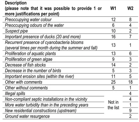
Table 2. 3: Breakdown of the concerns for each point indicated on the interactive map. ... 86
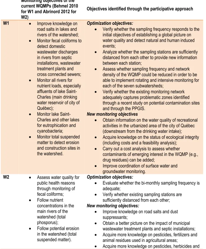
Table 2. 4: Summary of the current and new monitoring objectives of both watersheds. ... 89
Table 3. 1: Definitions of the terms referring to the elements used to design the conceptual model of the IDSS as well as the main elements and properties of these elements ... 109
Table 4. 1: Summary of the actionable tasks to take final decisions to optimize the W2 WQMP ... 161
List of figures
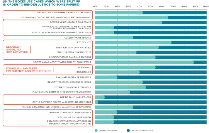
Figure 1. 1: Comprehensive diagram of use cases which need to be addressed when planning or optimizing a WQMP. ... 23 Figure 1. 2: Percentage of papers that considered the use case, as opposed to the percentage of papers that
did not. To facilitate the presentation, we summarized the categories “yes”, “+”, “++” and “+++” into the category “considered use case”, as opposed to the category “use case not”. The boxes that group together some of the use cases are use cases split apart from those considered in Table 1 in order to do justice to some of the authors. ... 36 Figure 2. 1: Flowchart illustrating the steps of the participative approach, as well as the objectives of each
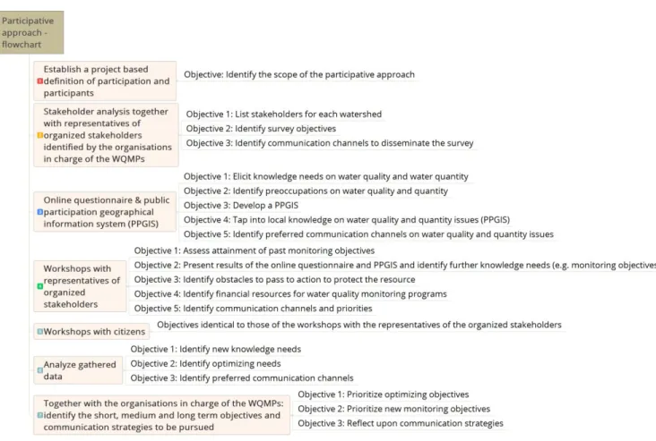
step. ... 68 Figure 2. 2: Location of the two case study watersheds within the province of Quebec, Canada, as well as their
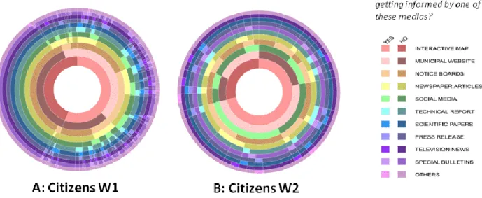
human catchment areas (areas that use water resources from the respective watersheds): the city of Mirabel is supplied by drinking water from the city of Saint-Jerôme, citizens from the cities of Montréal and Laval who have recreational homes in the north of the rivière du Nord watershed. The city of Québec is supplied by drinking water from the Saint-Charles river watershed (main density of citizens live outside of the watershed boundaries). ... 70 Figure 2. 3: Excerpt from the decision-support tree used during the workshops of the stakeholder analysis. .. 71 Figure 2. 4: Example of a sunburst diagram. ... 73 Figure 2. 5: Sunburst diagram showing the preferred modes of communication on water-related issues. A:
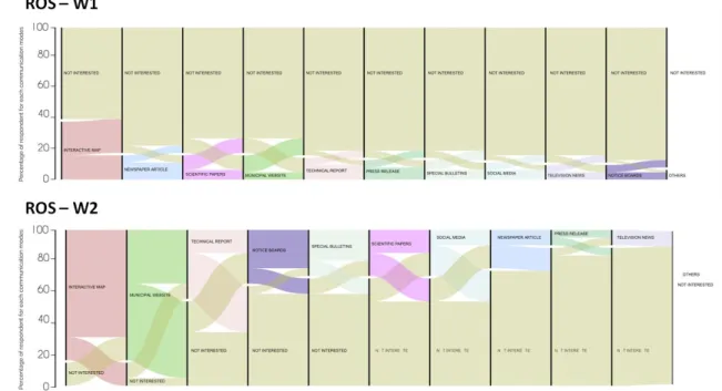
Citizens of W1; B: citizens from W2. ... 78 Figure 2. 6: Alluvial diagram showing the preferred modes of communication. Top (A): Citizens from W1;
Bottom (B): Citizens of W2 ... 78 Figure 2. 7: Sunburst diagram showing the preferred modes of communication on water-related issues. A:
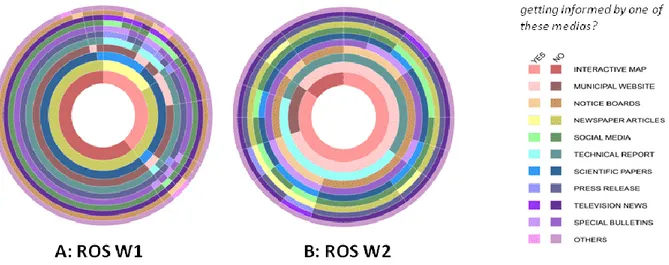
ROS of W1; B: ROS of W2. ... 79 Figure 2. 8: Alluvial diagram showing the preferred modes of communication. Top (A): ROS from W1; Bottom
(B): ROS of W2. ... 80 Figure 2. 9: Right: W1 (90 points from 60 respondents and 11 points with additional comments). Left: W2 (45
points from 32 respondents and 8 points with additional comments). Red and orange points: additional information was provided by the respondents; yellow points: the respondents chose one or more of the proposed topics from the list. ... 85 Figure 2. 10: Scales of effective integrated watershed management. ... 92 Figure 3. 1: Iceberg Model showing the various types of knowledge and their accessibility (adapted from
Vigenschow 2015). ... 102 Figure 3. 2: Iterative and evolving design method (Sources cited in this figure: (Charroux et al., 2010; Franklin,
2014; Power, 2001; Rhem, 2006)). ... 105 Figure 3. 3: Location of the two case studies. ... 106 Figure 3. 4: Upper left hand: End users consulted by the DSS architect from 2015 to 2017Lower left hand: IT
specialists consulted. Right hand: List of organizations with the number of subject matter experts consulted for each organization. (Abbreviations: APEL – Association pour la protection de
l’environnement du lac Saint-Charles et des Marais du Nord. STMUV: Bavarian State Ministry of the Environment and Consumer Protection. LFU : Landesamt fuer Umwelt Bayern. MDDELCC: Ministère du Développement durable, de l’Environnement et de la Lutte contre les changements climatiques.
VLMP: Maine Volunteer Lake Monitoring Program. EHESP-LERES: École des hautes études en santé publique - Laboratoire d’étude et de recherche en environnement et santé... 112 Figure 3. 5: General conceptual framework of the IDSS (design inspired by UML) based on the literature
review and the expert interviews. ... 114 Figure 3. 6: Use case model of the IDSS and actors and users interacting with the system (the light blue fill
defines the limits of the IDSS). ... 116 Figure 3. 7: Use-case model for the use case: Delimit a watershed (territory) subject to the WQMP. ... 120 Figure 3. 8: Fraction of the process ladder assigned to the use-case slice: Identify political boundaries. The
diamond-shaped end point of the process ladder refers to another use-case slice... 121 Figure 3. 9: Use-case slice: Evaluate a river station network. ... 126 Figure 4. 1: Global workflow of the optimization process of the WQMPs. The purpose of the participative
approach is to assess the attainment of past monitoring objectives and yield new monitoring objectives and optimization objectives. The results will influence the questions that the WQMP manager asks the IDSS to help the WQMP manager redesign the WQMP. ... 144 Figure 4. 2: Outline of the Lac Saint-Charles WQMP (W1) and the optimization objective tested in this paper.
... 145 Figure 4. 3: Outline of the Rivière du Nord WQMP (W2) and the three optimization objectives retained for this
paper. ... 146 Figure 4. 4: Questions to be asked (and integrated) into the system in order to understand the design of a
WQMP. ... 147 Figure 4. 5: Illustration of the dashboard of the W1 WQMP, as well as the features that may be consulted to
understand the WQMP and the available data sets. ... 148 Figure 4. 6: Onboarding the data of a WQMP: Step 1: Setting (e.g., sampling objectives; sampling site
justification; protocols; tools; probes; probe calibration protocols; laboratories; laboratory specificities; field observations; parameters and measuring units. Step 2: Importing shapefiles of watersheds and waterbodies, metadata on shapefiles; waterbody descriptions (e.g., bathymetry, length, fetch, volume, perimeter etc.). Step 3: Creating sampling sites (e.g., geographical location, justification, waterbody (from drop down lists created during steps 1 and 2. Step 4: Entering measurement contexts – field work (e.g., field personnel, time frame spent in the field, sampling protocols; sampling tools; probes and laboratories used; field measurements taken (e.g., transparency); field observations (e.g., rainfall and wind) etc.). Step 5: Importing data from Excel and CSV files from probes and laboratories automatically connected to the contexts. Step 6: Validating import reports and corrections if necessary. ... 149 Figure 4. 7: Illustration of the available filters for data extraction. It is possible to make 1 or n selections to
visualize data series or to export selection to EXCEL or CSV files. ... 152 Figure 4. 8: Extraction of the decision-support questions on available data series to validate (and understand)
integrity, comparability and outliers. ... 153 Figure 4. 9: Distribution of sampling stations on Lac Saint-Charles (lake). Maximum depth at each station:
C03: 17 m; C08: 13 m; C04: 7.5 m; C05: 5 m and C01: 2 m). ... 157 Figure 4. 10: A: illustrates the W2 sampling site network, the sampling site network and the sampling stations
suggested for retention or removal following the Kriging and Moran analysis. Stations without any specifications are considered as neutral, as neither their retention nor their removal will have an effect on the model. B: Suggested sampling site network after a first series of validations (section 2.5). ... 160
CHAPTER 1
Water quality monitoring strategies - a review and future perspectives
Behmel, S., M. Damour, Ludwig, R. Rodriguez, M..J (2016) Science of the total environment, 571, 1312 – 1329.
CHAPTER 2
Participative approach to elicit water quality monitoring needs from various stakeholder groups – an example of applied integrated watershed management
Behmel, S., M. Damour, Ludwig, R. Rodriguez, M..J
Accepted, April 2018: Journal of Environmental Management.
CHAPTER 3
Intelligent decision-support system to plan, manage and optimize water quality monitoring programs: design of a conceptual framework
Behmel, S., M. Damour, Ludwig, R. Rodriguez, M..J
Submitted with corrections according to reviewers to: Science of the total environment in November 2017.
CHAPTER 4
Optimization of river and lake monitoring programs using a particpative aproach and an intelligent decision-support system
Behmel, S., M. Damour, Ludwig, R. Rodriguez, M..J
Abbreviations
Abrinord – Organisme de bassin versant de la rivière du Nord;
APEL – Association pour la protection de l’environnement du lac Saint-Charles et des Marais du Nord;
DSS – Decision support systems; FC – Fecal coliforms;
IDSS – Intelligent decision support system;
IT – Information technology;
IWM – Integrated watershed management;
IWRM – Integrated Water Resources Management; PCA – Principal component analysis;
PPGIS – Public participation geographical information system; ROS – Representatives of organized stakeholders;
TP – Total phosporus; TSS – Total suspended solids; UML – Unified Modeling language;
W1 – Watershed 1 = Watershed of the Saint-Charles river; W2 – Watershed 2 = Watershed of the rivière du Nord;
WFD – Water Framework Directive;
WQMP – Water quality monitoring program;
Remerciements
Lorsque l’on commence une thèse, cela semble un projet bien personnel, qui impliquera, au mieux,
quelques personnes proches de nous, notre famille, notre directeur, notre employeur…
Mais on se rend rapidement à l’évidence : une thèse ne peut pas être accomplie sans l’aide, l’appui,
l’intérêt et l’investissement de beaucoup, beaucoup de gens. Pour faire un chiffre rond, je pense que
je dois remercier au moins 450 personnes…
Et j’espère n’en oublier aucune dans cette section consacrée aux remerciements.
Tout d’abord, je dédie cette thèse à mon père, Friedrich Behmel, décédé en juin 2010; j’aurais tant
aimé partager l’expérience avec toi.
Je tiens aussi à remercier :
Manuel Rodriguez, mon directeur de thèse, toujours disponible, constructif, enthousiaste… On ne
peut rêver d’un meilleur directeur. ¡Muchas gracias!
Ralf Ludwig, mon codirecteur, qui m’a accueillie pour un stage en Allemagne, toujours intéressé,
constructif… J’ai toujours senti qu’il me soutenait, tant à distance que lors de nos rencontres. Vielen
herzlichen Dank!
Mon comité d’évaluation : François Proulx, Richard Leduc, Roxane Lavoie et Warwick Vincent.
François, merci pour ton aide et ton soutien tout au long de mon parcours scolaire et professionnel.
Richard, merci de m’avoir poussée à obtenir un doctorat.
Roxane, merci pour ton aide concernant l’approche participative.
Warwick, merci d’avoir partagé ta passion pour la limnologie avec moi et d’avoir accepté à la
dernière minute de faire partie de mon comité d’évaluation.
Mon co-auteur, Mathieu Damour, sans toi je n’aurais jamais percé le mystère des statistiques! Merci
pour ton implication, ton aide, ta patience et merci à toi et Marie pour l’accueil chez vous et votre
famille.
Les organismes subventionnaires : le Conseil de recherche en sciences naturelles et en génie du
Canada (CRSNG) et la Chaire de recherche industrielle CRSNG gestion et surveillance de la qualité
de l’eau potable de l’Université Laval.
Les équipes et les conseils d’administration de l’Association pour la protection de l’environnement du
lac Saint-Charles et des Marais du Nord (APEL) et de l’Organisme de bassin versant de la rivière du
Nord (Abrinord) pour m’avoir ouvert leurs portes, m’avoir permis d’accéder aux données et avoir
organisé de nombreuses rencontres nécessaires à ma thèse.
Mélanie Deslongchamps, tu m’as encouragée, tu m’as laissé toute la latitude possible, tu étais une
complice… Merci pour tout!
Audrey Beaudoin-Arcand et Marie-Claude Bonneville (Abrinord), merci pour votre curiosité, votre
aide et votre disponibilité.
Estelle Baurès, merci pour ton accueil lors de mon stage en France; le marathon pour rencontrer
22 experts en deux semaines et demie n’aurait pas été possible sans toi.
Tous les répondants aux sondages dans le cadre de mon approche participative… 191 + 79 + 10 +
12 + 25 + 25 + (…) = environ 342 personnes! (Chapitre 2 )
Les 44 experts qui se sont prêtés à l’exercice de se laisser interviewer pendant des heures… La liste
complète se trouve dans les remerciements du chapitre 5.
Lyne Béland, merci pour ta gentillesse et ton accueil chaleureux… Et l’accès aux locaux!
Willem Fortin, merci d’avoir organisé mon cheminement, merci pour ton aide pour les inscriptions et
pour ta gentillesse.
Francine Baril, merci pour tout, et en particulier pour ton accueil toujours souriant!
Marie-Pier Bresse, merci d’avoir partagé ton bureau et merci pour ton aide concernant l’approche
participative; elle fut très précieuse.
Geneviève Cloutier, merci de m’avoir guidée, avec Marie-Pier, dans l’approche participative.
Tout le monde au CRAD et à l’ÉSAD, c’était un plaisir de vous côtoyer et de jouer à la pétanque!
Et,
Ma famille,
Mon mari Louis Perron, merci de m’avoir installé un bureau juste pour ma thèse; tu m’as vue plus
souvent de dos, courbée devant un ordinateur, que de face. Merci pour ton appui et ta patience.
Mon fils Nicolas Perron, merci de croire en moi.
Ma mère Ingrid, ma sœur Cheryl et mes frères Rüdiger et Harald, à distance, mais toujours présents!
L’équipe de WaterShed Monitoring,
Hervé Dandjinou, ami, mentor, partenaire en affaires, merci pour tout ton soutien moral, surtout dans
la dernière ligne droite! François Côté, Anna Scheili, Julia Cyr-Gagnon, Christian Saraïlis,
Rüdiger Behmel, c’est grâce à vous tous si on a pu bâtir une entreprise en même temps!
Mes ami(e)s, merci de votre patience, de votre appui et d’avoir toujours cru en ma réussite.
GENERAL INTRODUCTION
The general introduction of this thesis begins with a brief history of water resource management and knowledge acquisition related to water resources in order to place the research in a historical context (Section I). Section II provides an overview of modern integrated water resource management (IWRM) and modern means to acquire knowledge on water resources. The lessons learned from this review contextualize the need for improved water quality monitoring strategies and programs. They also support the thesis hypothesis and objectives presented in Section III. Section IV provides a summary of the methodology used to achieve the proposed specific objectives of the thesis. Finally, section V provides a short overview of the authors’ contributions to the papers. The references mentioned in this general introduction are presented at page 176 at the end of the thesis.
This thesis is divided into four main chapters (Chapters 1 to 4), each written in the form of a scientific paper. Each chapter presents a detailed section for the introduction, methodology, results, discussion and conclusions.
The last section is the general conclusion of the thesis. In the general conclusion, elements such as the originality of this thesis and its strengths and limitations are discussed. Finally, an outline is provided for future research.
I. Brief history of water resource management and knowledge acquisition processes and methods
To comprehend water resource management in the 21st century, it is necessary to position modern
understanding on water resource management as well as knowledge acquisition methods and processes on water resources in their historical context. To grasp a science or a concept, it is necessary to place historic facts in their cultural and historic background (Steleanu, 1986). Therefore, following is a brief overview of the historical development of water resource management and knowledge acquisition methods and processes on water resources. The main eras which are going to be presented are: Antiquity (1100 B.C. ~ 500 A.D.), the Roman Empire (27 B.C. – 476 A.D.), the Dark Ages (5th ~ 15th century A.D.), the Renaissance (14th ~ 15th
century A.D.), the Age of Discovery (15th ~18th century A.D.), and Industrialisation (18th century A.D. to today)
(Hotz, 2004a, b, c).
Several examples of watershed management and water resource management during the pre-Antiquity, Antiquity and Roman Empire periods show that authorities were aware of the human impacts on water quality and quantity. For instance, the Greek, Chinese and Romans would protect the watersheds upstream of their
drinking water sources through regulations and protective measures. The Chinese implemented laws to protect their forests by 300 B.C. The importance of forests to regulate the local hydrologic cycle and ensure water quality was well known. In terms of water resource management – water supply, wastewater evacuation, drainage of wetlands and irrigation – the civilizations during the pre-Antiquity and Antiquity periods demonstrated remarkable engineering skills (Neary et al., 2009). However, the functioning of the local, regional or global hydrologic cycle was not really known or understood, nor was it known how human-induced changes would impact the hydrologic cycle. In some civilizations that had flourished through water resource management favouring agriculture, this led to the overharvesting of water through irrigation and over-deforestation. This unsustainable management of water resources even contributed to the decline of civilizations such as the Sumerians (4000 – 2300 B.C.) and the Mayas (250 A.D.) (Hermon, 2008).
The lack of knowledge of the local, regional and global water cycle was addressed by scientists such as Aristotle. Aristotle contributed to the understanding of the water cycle, as well as to how human activities (wastewater in particular) could affect water quality (Neary et al., 2009; Steleanu, 1986). Before Aristotle, the water cycle was described vaguely: water rising from the ground by evaporation caused by the sun is precipitated and collected underground in a huge underground cavity of which the outlets were rivers. Aristotle nuanced this picture and came very close to what is known today as the natural hydrologic cycle (Steleanu, 1986).
During the Dark Ages, most of this knowledge was refuted and lost because the Bible was considered to be the standard of knowledge against which all new knowledge and ideas were measured. The water cycle was described in Ecclesiasts 1 as follows: “All the rivers go down to the sea, but the sea is not full; to the place where the rivers go, there they go again.” Based on this description, the theory was established that ocean water seeped into the ground and would soar upwards into the mountains from where the water would return to the rivers. The ground was viewed as a gigantic filter. This theory is also known as the sponge theory (Steleanu, 1986). Only during later periods of the Dark Ages was knowledge from the Greek philosophers accepted once again (Steleanu, 1986). Notwithstanding the sponge theory which precludes water resource protection, there are some known examples of forest protection during this era. For instance, King Louis the VI recognized the importance of forests for the conservation of water quality and promulgated “The Decree of Waters and Forests” in 1215 (Chang, 2013).
The Renaissance was marked by a change in the concept of having the Bible and Antiquity as a standard for scientific knowledge. For instance, Bernard Palissy (1510 – 1590) questioned the sponge theory and the theories from Antiquity on the hydrologic cycle. He presented the first modern water cycle in his book:
Discours admirable: De la nature des eaux et fontaines 1580 (Palissy and France, 1969). An example for this
period to protect water resources is the initiative of forest preservation by the Swiss to protect water quality and reduce the risk of avalanches. The Swiss designated 322 forests for protection between 1535 and 1777 (Neary et al., 2009).
The Age of Discovery, in particular the 17th century, was marked by a convergence of independent (no
communication between the scientists) discoveries and theories concerning the hydrologic cycle as we understand it today. Varenius (Varen) Bernard (1622 – 1651) in particular contributed significantly to the categorization and understanding of waterbodies (Chapter XV) and the hydrologic cycle (Chapter XVI) (Varenius and Newton, 1672). However, there was scant understanding of the quantification of global water cycle compartments (e.g., how much water is in the oceans, the ice cover, the atmosphere). The Age of Discovery was also marked by the coexistence of old and modern theories. For instance, the Jesuit Kirchner continued to defend the pre-Aristotle theory of having a huge cavity of water in the ground from which all rivers are fed (Steleanu, 1986).
At the end of the 19th century with industrialization well underway, there was still no consensus on the natural
hydrologic water cycle. Volger, an engineer and hydrologist, stated in 1877: “No water in the ground originates from rainwater.” This sparked a discussion on the source and formation on groundwater which lasted several decades. Only with Otozky and Mezger was some consensus on the hydrological cycle, the formation of groundwater and a certain quantification of the compartments of water achieved in 1922 (Steleanu, 1986). This is remarkable, since humans had been modifying the hydrologic cycle at the local, regional and global levels during all these eras. Industrialization was a culmination of the modification of the hydrologic cycle through the building of dams, deforestation, irrigation, urbanization, river channelization, cloud seeding, etc. (Turner, 1990). Indeed, Industrialization was marked by heavy impacts of human activities on the hydrologic cycle and on water quality, yet neither the impact of these activities on the hydrologic cycle or on water quality was well known. In addition, knowledge acquisition processes and concepts of water resource protection did not evolve (or receive general acceptance) as quickly as industrialization and engineering solutions (e.g., river regulation, dams and drinking water treatment). In the United States alone, there are more than 87 000 known dams (Townsend, 2014). As a consequence of this fast evolution, water quality and availability declined rapidly in many areas.
In addition, it is significant that knowledge acquisition processes on water quality and quantity were only formalized as a science by François Alphonse Forel (1841-1912). Forel is considered to be the founder of
limnology, the science of lakes and rivers (Steleanu, 1986). Limnology is an encompassing science that includes geography, hydrography, geology, climatology, hydrology, hydraulics, thermals, optics, acoustics, chemistry and biology (Forel and Forel, 2012). Each science has evolved and advanced at a different rhythm. Several monographies on lakes were written in Switzerland in the 17th and 18th centuries and are considered
as the precursors of limnology. The authors described lake biology, size and depth and their surrounding areas. Some of the instrumentation and tools to measure optics, nutrient concentrations and oxygen concentrations were also developed in the 18th and 19th centuries. For instance, Angelo Secchi developed the
Secchi disk in 1865 to measure water transparency and turbidity. The Secchi disk is still one of the instruments most used in limnology (Wetzel, 2001). For further reading on the development of these sciences, please consult Steleanu (1986).
Forel is considered to be the first to have pooled and formalized the existing knowledge of these sciences through his studies of lake Leman (starting in the late 1860ties) and to have adapted and implemented the first limnological studies program of Lake Constance in 1886. The program involved developing methods to understand the waterbody and providing methods for the characterization of water quality. Between 1886 and 1906, most European lakes (and others) were studied according to their morphology, physiography and biology (Steleanu 1986).
A groundbreaking element of modern limnology was the foundation of the International Society of Limnology (SIL) in Kiel, Germany in 1922. The founders sought to eradicate the borders erected during World War I between the scientists and science, since international collaboration was deemed essential for science and human wellbeing (Steleanu, 1986). Ever since, scientists working on water quality and quantity assessment processes have tried to keep abreast of the ever changing and additions of human-induced agents of degradation and transformation of water quality and quantity (Altenburger et al., 2015; Brack, 2015; Chapman, 1996; Islam et al., 2011; Ludwig et al., 2003; Steleanu, 1986; Von Der Ohe et al., 2009; Ward et al., 1990). Hence, as declining water quality and changes in the hydrologic cycle have become local, regional and global issues of concern due to industrialization and globalization – with additional challenges such as climate change, human population growth and the expansion of industrial and agricultural activities – many countries have begun to reform water governance and focus on sustainable development through an integrated approach, as recommended in the 1992 Agenda 21 (UNEP, 2012). Agenda 21 is the basis of modern IWRM, providing a program of actions for sustainable development on how states must apply “Integrated approaches to the development, management and use of water resources” (UNEP, 2012). Key elements of Agenda 21
include: instauration of restorative and protective measures based on knowledge acquisition and stakeholder involvement.
II. What is Modern Integrated Water Resource Management?
Agenda 21 set the standard for modern IWRM, yet does not provide a definition of the concept (Hermon, 2008). However, Agenda 21 has provided a series of key activities to improve and implement water resource management and knowledge acquisition processes. The knowledge acquisition processes include general recommendations regarding water quality and quantity monitoring, tapping into local knowledge (including specific traditional knowledge and women’s knowledge), citizen involvement and citizens’ groups and organizations of all types and at all levels (industry, government, non-government organizations, etc.) (UNEP, 2012).
On the local, regional, national and international levels, IWRM has been defined and redefined constantly. Therefore, it is still not possible to provide an universal definition of IWRM. For the subsequent discussion, a definition inspired by Conservation Ontario is proposed: IWRM implies managing all human activities and natural resource uses in an area, the watershed (i.e. the territory on which surface water converges toward a single point at a lower elevation, where it joins another water body), in a coordinated and sustainable manner (Conservation Ontario, 2010).
According to this definition, all water stakeholders – policymakers, city planners, water conservation organizations, industry sector, universities and the general public – should be part of the process in order to take joint decisions and actions to protect the resource for social, economic and environmental reasons (Bartram and Ballance, 1996; Demard, 2007; Islam et al., 2011). Also, as strongly recommended by the Rio Agenda 21, this implies that participative approaches should be developed and implemented in decision making, and that decision making must be based on sound scientific knowledge of the issues. Thus, it is necessary to develop and improve participatory practices and formalize knowledge acquisition processes such as water quality monitoring programs (WQMPs).
The term "area" in the definition of IWRM pinpoints another difficulty, namely distinguishing the watershed or territory to be subject to knowledge acquisition, participative approaches and, ultimately, the implementation of the restorative and protective measures. For instance, the watershed of the St. Lawrence River comprises parts of Canada and the United States with an area of 1.6 million km2 that drains more than 25% of the world's
freshwater (Environment Canada, 2013). A population of 30 million in the United States and 15 million in Canada (Environment Canada, 2013) lives within this watershed. Hence, the IWRM of this watershed requires
a transnational approach, yet must cover sub-watersheds managed along more local political boundaries, such as provinces or states and municipalities. Also, jurisdictions that have embraced IWRM impose watershed boundaries that generally encompass watersheds from large rivers. The size of these watersheds is very variable and can range from less than 1000 km2 to more than 170 000 km2 (Choquette and
Létourneau, 2008; Directive, 2000/60/EC). The question may be then asked as to whether the proposed watershed boundaries lend themselves to effective IWRM since they may be very heterogeneous in terms of their political boundaries, land use, geology and population dynamics. The proposed watershed boundaries do not take “human” catchment areas into account. Human catchment areas are defined in human geography as the area to which a city, institution or, in this case, water resources in a watershed, attracts a population that uses its services. Therefore, the people living in the human catchment area may not be considered by the IWRM of these watersheds. Yet, they may be the principal users or population benefitting from the water of a watershed where they do not live and from which they are excluded from management decisions.
Knowledge on water quality and quantity monitoring has evolved rapidly since the 17th to the 19th century
monographies on Swiss lakes and Secchi and Forel in the 19th century. WQMPs have been implemented in
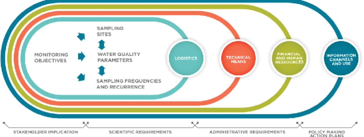
many countries and at different scales (Davies-Colley et al., 2011; Fölster et al., 2014; Timmerman et al., 2011). A definition of monitoring is provided by the International Organization for Standardization: “Monitoring is the programmed process of sampling, measurement, and subsequent recording or signalling, or both, of various water characteristics, often with the aim of assessing conformity to specific objectives.” Several sub-divisions are possible. Here the aspect of monitoring considered as the “long term, standardized measurement and observation of the aquatic environment in order to define status and trends” is addressed (Bartram and Ballance, 1996). The challenges common to all WQMPs are: select the territory subject to the WQMP; set precise monitoring objectives (knowledge needs); identify a sampling site network; select water quality parameters; set sampling frequency and recurrence; ensure quality control, assessment and data storage; produce timely, understandable and robust information; and embed the knowledge needs, scientific considerations, logistics and administrative considerations into the available human, technical and financial resources (Behmel et al., 2016; Harmancioglu et al., 1999; Loftis and Ward, 1980; Timmerman et al., 2000; Ward et al., 1990).
Several methods exist to optimize or implement a WQMP: empirical, conventional statistical and “emerging methods” (Chen et al., 2012). The empirical method may be defined as planning, managing and optimizing WQMPs based on handbooks, guidelines and subject matter expert knowledge. The conventional statistical methods include identification and optimization of the amount of monitoring stations and water quality parameters based on techniques like principal component analysis (Olsen et al., 2012; Ouyang, 2005)); factor
and correlations analysis (Pinto and Maheshwari, 2011); and correlation and cluster analysis (Khalil et al., 2010). “Emerging methods” include techniques available because of increased modern-era computing capacities: genetic algorithms (Khalil et al., 2011; Park et al., 2006); entropy analysis (Mahjouri and Kerachian, 2011); matter-element analysis (Chen et al., 2012) that may be combined with geographic information systems (GIS) (Park et al., 2006); artificial neural networks and maintenance of variance extension techniques (Khalil et al., 2011), self organizing maps (Tobiszewski et al., 2010), etc.; for example, to determine sampling locations based on the hydrological network and contamination fate (Telci et al., 2009).
However, all these methods are rather compartmentalized: they do not address the process of planning, managing and optimizing WQMPs in a holistic and, to some extent, standardized manner. For example, a network based on the empirical method may be biased by arbitrary decisions regarding the amount of stations, sampling frequencies and number of parameters to sample (Strobl and Robillard, 2008). The statistical methods do not necessarily take micro-location, accessibility, mixing and local influences into account, nor do they consider all the administrative elements of planning a WQMP (financial, human, technical resources). At some point of their application, all these methods require decision making by experts (Beveridge et al., 2012; Gray, 2010; Olsen et al., 2012; Strobl and Robillard, 2008). Some of the emerging methods do not consider the fact that the problem domain is not stable and is subject to constant changes in land use and knowledge needs (Van Leeuwen, 2012). All the methods have one thing in common: subject matter expert knowledge is required at some point and decisions must be taken that will influence the results and the recommendations of the WQMPs. Therefore, it is essential to capture these decisions in order to understand their impact and render them transferable and transparent.
In addition, WQMPs are often based on imprecise objectives. This may be due to a failure to make allowances for participative approaches to identify the knowledge needs of citizens, organizations and decision makers (Government of Australia, 2009; Bartram and Ballance, 1996; De Stefano, 2010; Harmancioglu et al., 1999; Quevauviller et al., 2005). This shortcoming is real, despite the fact that it is a major premise of IWRM. This situation is probably associated with the fact that public participation can take many forms depending on the goals pursued, the scope, participants to be involved and complex local, regional and national structures (European Commission, 2003). A critical review of the methods used to implement WQMPs and further analysis of the potential contribution of participative approaches in this area are presented in Chapter 2 of this thesis. The result of this critical review strongly motivates the specific objectives and methodological choices made for the various components of this thesis.
III. Hypothesis and objectives
Both the historic context and the review of modern IWRM show that there is a need to develop and integrate knowledge acquisition processes into water-related questions. It has also been shown that it is necessary to encourage the participation of all parties involved in water resource protection and restoration. Two main issues for modern IWRM were identified: the need to obtain a reliable assessment of water quality and quantity through WQMPs; the need to encourage stakeholder involvement and identify the scale of the territories to be targeted. Combining WQMPs and stakeholder involvement will contribute to understanding the stakes of water resource management and prove instrumental in joint decision making to protect and restore water resources.
In line with this reflection, the following research hypotheses are proposed for this thesis:
(1) Existing approaches to develop WQMPs are inadequate for the real-world contexts of IWRM and do not sufficiently address all the issues related to planning, managing and optimizing WQMPs. (2) Using an IDSS to plan and optimize a WQMP combined with the participative approach
facilitates the planning and optimization of WQMPs in line with local or regional needs, resources and WQMP planning issues.
(3) Using a participative approach to prompt stakeholders to voice their knowledge needs on water quality and quantity within a watershed is useful in identifying monitoring objectives more representative of these issues within a given watershed than those proposed in the literature and obtained through the collaboration of experts alone.
(4) Using an IDSS combined with a participative approach to optimize a WQMP results in a WQMP which is more representative of local or regional needs, resources and WQMP optimizing issues than a standard optimizing method.
(5) Using an IDSS that considers expert knowledge, as well as information from the literature, yields WQMPs for which the decision-making processes are more transparent and for which
knowledge (from both the literature and from subject matter experts) and decisions are transferable over time and space.
The principal objective of this thesis is to develop an Intelligent Decision-Support System (IDSS) to plan, manage and optimize water quality monitoring strategies integrating participative approaches. More specifically, the objectives are to:
(1) Design the conceptual model of the IDSS based on a literature review and subject matter expert knowledge;
(2) Develop a participative approach to determine knowledge needs on quality and tap into local knowledge required for water quality monitoring programs;
(3) Test both the IDSS and the participative approach in real watershed case studies.
The chapters of this thesis are written in the form of scientific papers (published, submitted, or to be submitted, to scientific journals). The first paper, Chapter 1, presents a critical literature review of WQMP planning and optimization methods. The second paper, Chapter 2, explains the work carried out to develop and test a participative approach to determine knowledge regarding water quality and quantity issues. The third paper, Chapter 3, details the development of the IDSS. Finally, the fourth paper, Chapter 4, demonstrates how the results from the participative approach to determine knowledge needs drive the IDSS and how the IDSS can be used to optimize WQMPs.
The titles of the chapters read as follows:
1. Chapter 1: WATER QUALITY MONITORING STRATEGIES - A REVIEW AND FUTURE PERSPECTIVES (PUBLISHED)
2. Chapter 2: PARTICIPATIVE APPROACH TO RETRIEVE WATER QUALITY MONITORING NEEDS FROM STAKEHOLDER GROUPS – AN APPLICATION OF INTEGRATED WATERSHED MANAGEMENT (SUBMITTED – UNDER REVIEW)
3. Chapter 3: INTELLIGENT DECISION-SUPPORT SYSTEM TO PLAN, MANAGE AND OPTIMIZE WATER QUALITY MONITORING PROGRAMS: DESIGN OF A CONCEPTUAL FRAMEWORK (SUBMITTED – UNDER REVIEW)
4. Chapter 4: OPTIMIZATION OF SURFACE WATER MONITORING PROGRAMS USING A PARTICIPATIVE APPROACH AND AN INTELLIGENT DECISION SUPPORT SYSTEM (SUBMITTED-UNDER REVIEW).
IV. Thesis methodology in brief
For each of the four papers, a detailed methodology is provided. Here, only an overview of the methodological aspects of the thesis components is provided.
To develop the conceptual model of an IDSS to assist watershed managers in the planning, management and optimization of WQMPs, an iterative design method inspired by the Agile development concepts was chosen. Agile development concepts are used to build software systems through constant interaction with end users and by implementing components of the system progressively rather than designing a system based on a large and detailed requirement analysis at the outset of the project and then implementing the system in its globality (Schön et al., 2016). The advantage of the Agile method is that it keeps the risks scalable and provides users with a set of implemented elements of the system that they can understand, test and provide feedback on during the entire process (Beck et al., 2001).
The aim was to integrate knowledge from the literature and subject matter experts into the IDSS. Therefore, first a literature review of more than 100 papers, handbooks and guidelines was conducted (Chapter 1). Thirty-four papers of this literature review were analyzed in depth based on the information and decision support they would provide to the main use cases identified during this literature review: Delimit a watershed (territory)
subject to the WQMP; Define monitoring objectives; Classify waterbodies; Establish a sampling site network; Select water quality parameters; Establish sampling frequency and recurrence; Plan field work; Plan quality control and assessment; Establish communication channels within the WQMP; Establish communication channels for the information produced by the WQMP; Prepare data handling, storage and reporting; and Evaluate resource needs.
In order to close the gaps in information and decision support identified through the literature review, a series of interviews with 44 water quality experts from Canada, the United States, Germany, France, Switzerland and Spain were conducted. To ensure that the IDSS would ultimately respond to the end users’ needs, the potential end users from the two watershed case studies were consulted throughout the process and provided with implemented elements of the IDSS to be tested. The collaboration culminated with a lengthy workshop to identify the end users’ needs, including all type of users within these organizations (e.g., administrator, field technician, WQMP manager). The conceptual model is described mainly in the Unified Modeling Language (UML). The sequence of operations performed by the system (use cases) and related deliverables (use-case scenarios, libraries, decision-support trees, etc.) are described according to the concepts of agile development and Use Case 2.0. (Jacobson et al., 2016) (Chapter 3 and Appendix A).
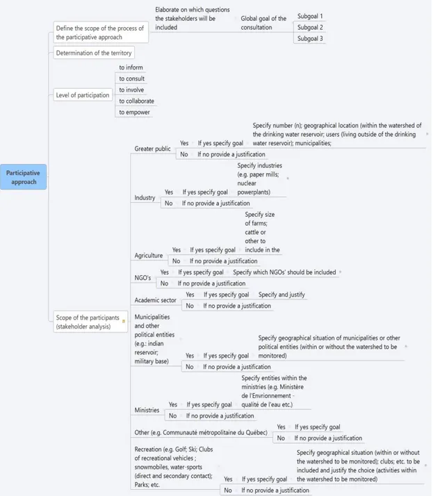
The participative approach that was developed to identify all concerns and knowledge needs in the territory subject to a WQMP first proposes two steps in the preparation of the participative approach which can be adapted to local and regional needs. These steps include a stakeholder analysis through workshops, as well as the preparation, testing and communication of an on-line survey featuring an interactive map. The participative approach was tested on two watershed case studies of the province of Quebec, the Saint-Charles river watershed north of Quebec City (W1) and the Rivière du Nord river watershed northeast from the city of Montreal (W2). The target groups of the participative approach included citizens and representatives of organized stakeholders (ROS) identified through the stakeholder analysis. Subsequently, the results of the participative approach were submitted to a statistical analysis of the results based on specific goals (e.g., eliciting knowledge needs and concerns, as well as preferred communication means). The results were then presented to ROS and citizens who evinced interest in participation through the survey. Members of the organizations in charge of the WQMPs of the two case studies were also present at these workshops. The aim of these workshops was to assess the achievement of past monitoring objectives and identify future objectives and needs of the local WQMPs, taking into account the results of the survey. Finally, the results of this process led to a list of optimization objectives and new monitoring objectives for which priorities were established with the respective WQMP managers of the two case studies (Chapter 2).
Finally, the IDSS was tested on the two case studies, W1 and W2. Some of the optimization objectives determined through the participative approach were selected to test the IDSS. Then, some of the features of the IDSS were tested. These features included some that had been implemented and some not yet implemented. The testing included verifying the decision support provided by the IDSS to: understand the existing WQMP; onboard the data and information related to these WQMPs into the data base EnkiTM
connected to the IDSS (EnkiTM was developed in earlier work (Behmel, 2010)); use the IDSS to select
optimization methods provided in the literature; use the IDSS to provide decision support during the application of these optimization methods; and finally, to provide decision support to analyze the results of these optimization methods and final expert (IDSS) decision support to come to a final, and transparent, decision for the optimized WQMPs (Chapter 4).
V. Authors’ contribution to the papers
The content of this thesis is an original idea of the author, Sonja BEHMEL. All four papers in this thesis were written by the same four authors in the following order: BEHMEL, Sonja; DAMOUR, Mathieu; LUDWIG, Ralf and Manuel RODRIGUEZ. The idea to develop and test both the IDSS and the participative approach is issued from the earlier work and experience of Sonja BEHMEL in the field of water quality monitoring and IWRM. Thus, the work presented in all four papers in this thesis is essentially proposed, executed and written
by Sonja BEHMEL. Manuel Rodriguez, being the director of the thesis, contributed significantly to the work through discussions, critical review, editing and providing the necessary resources to the completion of the papers and the thesis. Ralf Ludwig, co-director of the thesis, also contributed through critical review, editing and discussions. He also provided the opportunity of an internship in Germany where he introduced Sonja Behmel to several subject matter experts on WQMPs for the interviews (third paper). Mathieu Damour contributed significantly to each of the papers through his expertise on statistical methods and on their application. Every section of the four papers relating to statistics was realized in many hours of joint discussions as to the specific needs relating to the papers. The execution of the statistical analysis in the second and fourth paper is attributed to Mathieu Damour. He was also key to explaining the rationale of the statistical methods and contributed markedly to the analysis of the results and to the thesis author’s learning curve on statistics.
1. CHAPTER 1: Water quality monitoring strategies - a review and future
perspectives
Stratégies de suivi de la qualité de l’eau – revue de la littérature et
perspectives d’avenir
Résumé. Il est primordial d’obtenir une évaluation fiable de la qualité de l’eau au moyen d’un programme de suivi de la qualité de l’eau (PSQE) afin de permettre aux décideurs de comprendre, d’interpréter et d’utiliser cette information comme fondement de leurs actions qui visent à protéger la ressource. Depuis les années 1940, le défi que pose le suivi de la qualité de l’eau a été amplement abordé dans la littérature. Toutefois, il n’existe à ce jour aucune stratégie pratique, holistique et généralement reconnue sur laquelle fonder chacune des étapes d’un PSQE. L’objectif de cet article est de faire un compte rendu des cas d’utilisation que doit aborder le gestionnaire d’un bassin versant en vue de concevoir ou d’optimiser un PSQE, et ce, du défi que posent la définition des objectifs de suivi, le choix des sites d’échantillonnage et des paramètres de qualité d’eau ainsi que la définition de la fréquence d’échantillonnage, à la prise en compte de la logistique et des ressources, en passant par la mise en œuvre d’actions basées sur l’information recueillie au moyen du PSQE. Une recension des écrits et une critique de l’information, des approches et des outils à la disposition des gestionnaires de bassins versants ont été proposées afin d’évaluer la manière dont l’information existante peut être intégrée à une solution holistique, évolutive et facile à utiliser. En raison des différences entre les exigences réglementaires, les normes relatives à la qualité de l’eau, les contextes géographiques et géologiques, l’occupation des sols et les autres particularités de chaque site, il est impossible de fournir une solution universelle. Cependant, nous soumettons l’hypothèse qu’un système intelligent d’aide à la décision (SIAD) basé sur les connaissances d’experts qui intégrerait les approches existantes et les études antérieures pourrait, en fonction des exigences particulières du site, guider le gestionnaire d’un bassin versant tout au long du processus. Par ailleurs, il est essentiel de puiser dans les connaissances locales pour déterminer les besoins en connaissances de tous les intervenants au moyen d’une approche participative fondée sur des systèmes d’information géographique et des questionnaires de sondage adaptables. Nous croyons que de futures études devraient se pencher sur le développement de telles approches participatives ainsi que sur l’examen plus approfondi des avantages qu’offre un SIAD pouvant être rapidement mis à jour et permettant au gestionnaire d’un bassin versant d’obtenir, en temps opportun, un point de vue global ainsi que de l’aide concernant tous les aspects de la conception et de l’optimisation d’un PSQE.
Abstract. The reliable assessment of water quality through water quality monitoring programs (WQMPs) is crucial in order for decision-makers to understand, interpret and use this information in support of their management activities aiming at protecting the resource. The challenge of water quality monitoring has been widely addressed in the literature since the 1940s. However, there is still no generally accepted, holistic and practical strategy to support all phases of WQMPs. The purpose of this paper is to report on the use cases a watershed manager has to address to plan or optimize a WQMP from the challenge of identifying monitoring objectives; selecting sampling sites and water quality parameters; identifying sampling frequencies; considering logistics and resources to the implementation of actions based on information acquired through the WQMP. An inventory and critique of the information, approaches and tools placed at the disposal of watershed managers was proposed to evaluate how the existing information could be integrated in a holistic, user-friendly and evolvable solution. Given the differences in regulatory requirements, water quality standards, geographical and geological differences, land-use variations, and other site specificities, a one-in-all solution is not possible. However, we advance that an intelligent decision support system (IDSS) based on expert knowledge that integrates existing approaches and past research can guide a watershed manager through the process according to his/her site-specific requirements. It is also necessary to tap into local knowledge and to identify the knowledge needs of all the stakeholders through participative approaches based on geographical information systems and adaptive survey-based questionnaires. We believe that future research should focus on developing such participative approaches and further investigate the benefits of IDSS’s that can be updated quickly and make it possible for a watershed manager to obtain a timely, holistic view and support for every aspect of planning and optimizing a WQMP.
Keywords: Water quality monitoring programs; intelligent decision support system; participative approaches Abbreviations: DSS - Decision support systems; IDSS - Intelligent decision support systems; IWM - Integrated Watershed Management; PCA - Principal component analysis; WFD - Water Framework Directive; WQMP - Water quality monitoring program; WQP - water quality parameter.