THÈSE
En vue de l’obtention du
DOCTORAT DE L’UNIVERSITÉ DE TOULOUSE
Délivré par l'Université Toulouse 3 - Paul Sabatier
Présentée et soutenue par
Georgia KATSIGIANNI
Le 15 novembre 2019
hybridation multi-GNSS pour le positionnement précis
Ecole doctorale : SDU2E - Sciences de l'Univers, de l'Environnement et de
l'Espace
Spécialité : Sciences de la Terre et des Planètes Solides Unité de recherche :
GET - Geosciences Environnement Toulouse
Thèse dirigée par
Felix PEROSANZ et Sylvain LOYER
Jury
M. Pierre BRIOLE, Rapporteur M. Urs HUGENTOBLER, Rapporteur
M. Laurent MOREL, Examinateur M. Guillaume RAMILLIEN, Examinateur M. Felix PEROSANZ, Directeur de thèse M. Sylvain LOYER, Co-directeur de thèse
1
Multi-GNSS Hybridization for Precise Positioning
Thesis Dissertation
of
Georgia Katsigianni
3
Acknowledgements
The present doctoral dissertation was prepared from research conducted during the academic years from November 2016 to November 2019 under the supervision of Dr. HDR Felix Perosanz and Dr. Sylvain Loyer. Financial support was shared by Centre National d’Etudes Spatiales (CNES) and Collecte Localisation Satellites (CLS Group). This thesis was prepared for the Doctoral School (Ecole Doctorale-ED) of "Geosciences, Astrophysics, Space and Environmental Sciences" ("Sciences de l' Univers, de l' Environnement et de l' Espace"-SDUEE) at Paul Sabatier University (Toulouse III).
First and foremost, I would like to deeply thank my two supervisors Felix Perosanz and Sylvain Loyer for giving me the opportunity to work on this PhD topic, for their valuable support and guidance and for our perfect cooperation during the whole time of my studies.
Secondly, I would like to acknowledge Flavien Mercier (CNES), Alvaro Santamaria (CRNS), Jean-Charles Marty (CNES), Jean-Michel Lemoine (CNES), Miriam Zoulida (CNRS), Mini Gupta (CNRS), Adrien Mezerette (CLS), Laetitia Versini (CLS) and Térence Desclaux (CLS) for their help, cooperation and for our fruitful discussions and exchange of ideas.
To the members of the Jury, Pierre Briole (ENS), Urs Hugentobler (TUM) and Laurent Morel (CNAM), I would like to give my gratitude for their willingness to read and examine my work and for their objective judgement. Additionally, I show appreciation to the members of my thesis committee Jean-François Crétaux (LEGOS/CNES), Paul Rebischung (LAREG/IGN), Flavien Mercier (CNES) and Alvaro Santamaria (CNRS) that followed my progress every year and gave me their advice.
I am also very grateful for the support of all my colleagues from CNES, CLS, CNRS and GET-OMP for their positive mood, humor and kindness. They all made my stay in ‘The Pink City’ during these three years very pleasant.
Last but not least, I would like to express my deepest gratitude to my family and to my fiancé Sean. Although they were very far away from me during these years, they were always giving their faith, support and patience. Finally, thanks to all my friends for their encouragement.
I thank you all! Gina
5
Abstract in English
GNSS are widely used for precise positioning applications of geosciences and especially space geodesy. So far, mainly the existing GPS was extensively used for scientific applications. With the arrival of the new European Galileo system it became imperative to include the new system in the studies and check the new capabilities that it will bring as a system alone and as combined together with the others in a Multi-GNSS processing.
The CNES/CLS analysis center of the IGS is weekly calculating GNSS (GPS, GLONASS and Galileo) products that can be taken from any kind of user to perform precise positioning. A way to achieve the best accuracy possible is to resolve the unknown integer ambiguities of the phase measurements. Up until now, the CNES/CLS was performing ambiguity resolution to the GPS system using the zero-difference method. In this way they are able to deliver precise satellite orbits and precise clock products with phase fixed ambiguities.
The goal of this work was to implement and validate if the method can be also applied for the Galileo system. The method applied from the CNES/CLS is consisting of two further steps. The first one is the resolution of the Wide-Lane ambiguities. The Galileo Wide-Lane satellite biases have been proven to be stable over long periods of time. In addition, there is homogeneity in the way they are observed from different types of receivers. These findings were used and the Wide-Lane biases were successfully resolved with nearly 100% success rate percentage. The second step of zero-difference method is the Narrow-Lane ambiguity resolution. This step was executed for the Galileo system together with the GPS system in a Multi-GNSS Precise Orbit Determination processing. Galileo ambiguity fixing success percentage is around 93%, nearly similar to the one of the GPS system. The integer property of the Galileo phase clocks is demonstrated. Both orbit overlaps and orbit validation using SLR validation methods showed that ambiguity resolution improves mainly in the normal and the along track direction. Galileo orbit overlaps in 3D RMS showed an improvement of around 50%, from around 7 cm to 3.5 cm. The results of this work were used by the CNES/CLS IGS AC that has announced the delivery of weekly Galileo precise orbits, clocks and Wide-Lane satellite biases. A new method is also introduced on how to compare ambiguity resolution results for a common overlapping period. This method is also used to speculate the agreement and the disagreement between two different daily solutions.
Finally, it was examined the post-processed kinematic PPP and PPP-AR using Galileo-only, GPS-only and Multi-GNSS (GPS + Galileo) constellations. The interest was to validate the accuracy for each GNSS system individually but also of their combination. Results showed that Galileo-only positioning accuracy is nearly at the same level of accuracy as GPS-Galileo-only. The use of Galileo system improves the performance of the GPS positioning giving mm level repeatability. The contribution of Galileo ameliorates the positioning accuracy around 30% in all directions (comparison GPS PPP-AR and Multi-GNSS PPP-AR).
6
This proved that the Galileo constellation together with GPS will give improved precise positioning with respect to the current GPS-only.
All these are indications that the Galileo system will contribute to precise positioning required by geoscience applications through a Multi-GNSS (GPS + Galileo) solution.
Key Words
GNSS, Galileo, GPS, Multi-GNSS, Ambiguity Resolution, Zero-difference, PPP, PPP-AR, IPPP, Precise Positioning
7
Résumé en Français
Les systèmes GNSS sont largement utilisés pour les applications de positionnement précis en géosciences, et en particulier en géodésie spatiale. Jusqu'à présent, les mesures du système GPS sont principalement utilisées seules pour des applications scientifiques. L’arrivée de la constellation européenne Galileo, rend possible les études sur ce nouveau système pour vérifier ses capacités et ses possibilités seul ou combiné avec GPS dans un traitement Multi-GNSS.
Le centre d'analyse CNES/CLS de l'IGS calcule de manière hebdomadaire les produits GNSS (GPS, GLONASS et Galileo) ; ces produits sont utilisés pour les applications scientifiques de positionnements précis. Un moyen d'obtenir la meilleure précision possible consiste à résoudre les ambiguïtés entières, inconnues, des mesures de phase. Jusqu'à présent, le centre d’analyse CNES/CLS effectue une résolution d'ambiguïté sur les observations GPS en utilisant la méthode zéro-différence et fournit les orbites et les horloges précises des satellites avec des ambiguïtés de phase fixées.
L'objectif de ce travail est d’implémenter et valider si la méthode zéro-différence peut également être appliquée au système Galileo. Celle-ci comprend deux étapes. La première est la résolution des ambiguïtés de la combinaison Wide-Lane ; il est prouvé que les biais des satellites Galileo Wide-Lane sont stables sur de longues périodes et homogènes pour les différents types de récepteurs. Ces résultats ont permis de résoudre les biais Wide-Lane avec un taux de réussite proche de 100%.
La deuxième étape de la méthode de zéro-différence est la résolution des ambiguïtés Narrow-Lane. Cette étape a été mise en œuvre pour le système Galileo dans un traitement de détermination précise de l’orbite multi-GNSS (avec les données GPS). Le pourcentage de succès de Galileo en matière de résolution des ambiguïtés atteint environ 93%, ce qui est similaire au système GPS. La propriété entière des horloges de phase Galileo permettant d’utiliser ces calculs au niveau utilisateur est démontrée. Les recouvrements d’orbite et « le Satellite Laser Ranging » utilisés pour valider les orbites obtenues ont montré une amélioration d'environ 50% des RMS3D (d'environ 7 cm à 3,5 cm) principalement dans les directions normales et tangentielles. Les résultats de ces travaux ont pu être appliqués aux produits du CA IGS CNES/CLS qui a commencé la livraison des produits « entiers » Galileo (orbites précises horloges et biais Wide-Lane satellites). D’autre part nous avons proposé une nouvelle méthode de comparaison des ambiguïtés.
Enfin, des traitements PPP et PPP-AR cinématiques sont réalisés en utilisant des mesures des constellations Galileo et GPS seules ou dans un traitement Multi-GNSS (GPS + Galileo). L’intérêt est de valider la précision de chaque système GNSS individuellement mais aussi de vérifier leur compatibilité et de mesurer l’intérêt de traitement combinés. Les résultats ont montré que la précision de positionnement du système Galileo utilisé seul est pratiquement du même niveau
8
que celle obtenue avec le système GPS. D’autre part l'utilisation conjoint des deux systèmes améliore les performances du positionnement GPS en offrant une répétabilité au niveau millimétrique et un gain de précision de positionnement d’environ 30% dans toutes les directions (comparaison GPS PPP-AR et Multi-GNSS PPP-AR).
Tout cela indique que le système Galileo peut contribuer de manière significative au positionnement précis requis par les applications de géoscience via une solution Multi-GNSS (GPS + Galileo).
Mots clés
GNSS, Galileo, GPS, Multi-GNSS, Résolution des ambiguïtés, zéro-différence, PPP, PPP-AR, IPPP, Positionnement précis
9
Acronyms
AC Analysis Centers
ACC Analysis Center Coordinator ADEV Allan Deviation
ANTEX Antenna Exchange Format APC Antenna Phase Center AR Ambiguity Resolution
BDS BeiDou Navigation Satellite System CNES Centre National d’Etudes Spatiales CLS Collecte Localisation Satellites
CODE Center for Orbit Determination in Europe COSPAS Space System for Search of Distress Vessels DoD Department of Defense
DORIS Doppler Orbitography and Radiopositioning Integrated by Satellite DOY Day of Year
EC European Commission ESA European Space Agency FOC Full Operational Capability
GGOS Global Geodetic Observing System GGTO GPS to Galileo Time Offset
GIA Glacial Isostatic Adjustment
GIOVE Galileo In-Orbit Validation Element GIS Geographic Information Systems
GLONASS Globalnaya Navigatsionnaya Sputnikovaya Sistema GNSS Global Navigation Satellite Systems
GPS Global Positioning System
GRGS Groupe de Recherche de Géodésie Spatiale (Space Geodesy Research Group) GSA European Global Navigation Satellites Systems Agency
GST Galileo System Time
GTRF Galileo Terrestrial Reference Frame HAS High Accuracy Service
IAG International Association of Geodesy IAU International Astronomical Union
IERS International Earth Rotation and Reference Systems Service IGS International GNSS Service
ILRS International Laser Ranging Service IOV In-Orbit Validation
IPPP Integer Precise Point Positioning
10 ISB Inter-system Bias
ITRF International Terrestrial Reference Frame
IVS International VLBI Service for geodesy and astrometry LEO Low Earth Orbit
LOD Length of Day
LSE Least Squares Estimation MEO Medium Earth Orbit MGEX Multi-GNSS Experiment
NAGU Notice Advisory to Galileo Users NAVIC Navigation Indian Constellation NL Narrow Lane
NRCan Natural Resources Canada OS Open Service
PCO Phase Center Offset PCV Phase Center Variation
PE-90 Parameters of the Earth 1990 (GLONASS geodetic datum) PM Polar Motion
POD Precise Orbit Determination PPP Precise Point Positioning
PPP-AR Precise Point Positioning with Ambiguity Resolution PPS Precise Positioning Service
PRS Public Regulated Service QZSS Quasi-Zenith Satellite System RMS Root Mean Square
VLBI Very-Long-Baseline Interferometry
SARSAT Search and Rescue Satellite-Aided Tracking SBAS Space-based augmentation systems
SLR Satellite Laser Ranging SPS Standard Positioning Service TAI International Atomic Time WGS-84 World Geodetic System 1984 WL Wide Lane
UN United Nations
UN-GGIM United Nations initiative on Global Geospatial Information Management UTC Universal Time Coordinated
11
Table of Contents
Acknowledgements ... 3 Abstract in English ... 5 Résumé en Français ... 7 Acronyms ... 9 Table of Contents ... 11 1. Introduction ... 13 1.1 Introduction in English ... 13 1.2 Introduction en Français ... 141.3 Outline of the thesis dissertation ... 16
2. GNSS in science ... 17
2.1 Introduction ... 17
2.2 The science of Geodesy ... 17
2.3 The Global Geodetic Observing System (GGOS) ... 19
2.4 The GNSS systems ... 21
The GPS system ... 21
The GLONASS system ... 21
The Galileo system ... 22
2.5 The GNSS systems as a geodetic technique... 23
2.6 The IGS Service and the MGEX ... 26
IGS ... 26
MGEX ... 26
The CNES/CLS Analysis Center ... 28
2.7 Conclusions ... 28
3. GNSS Measurements ... 29
3.1 Introduction ... 29
3.2 GNSS observations used for Geodesy ... 30
3.3 Integer Ambiguity Resolution ... 32
3.4 Zero-difference Ambiguity Resolution Method ... 34
Wide-Lane ambiguity fixing ... 34
Narrow-Lane ambiguity fixing ... 39
3.5 Conclusions ... 42
4. Galileo Wide-Lane AR ... 43
4.1 Introduction ... 43
4.2 Galileo Wide-Lane satellite biases ... 43
12
4.4 Conclusions ... 55
5. Galileo Narrow-Lane AR ... 57
5.1 Introduction ... 57
5.2 Multi-GNSS Narrow-Lane Ambiguity Resolution ... 57
5.3 Multi-GNSS POD Models ... 61
5.4 Validation of the results ... 62
Ambiguity Fixing ... 63
Integer Recovery Clocks Overlaps ... 63
Orbit Overlaps ... 64
SLR Residuals ... 69
Inter System Biases ... 70
5.5 Method for AR solution comparison ... 73
5.6 Conclusions ... 80
6. Precise Point Positioning ... 81
6.1 Introduction ... 81
6.2 PPP with Ambiguity Resolution... 82
6.3 PPP and PPP-AR on a global network ... 100
6.4 Conclusions ... 108
7. Conclusions and Suggestions ... 109
7.1 Conclusions in English ... 109
7.2 Suggestions for future work ... 110
7.3 Conclusions en Français ... 111
7.4 Suggestions de travaux futurs... 113
Bibliography ... 115 Table of Figures ... 123 Table of Tables ... 127 Appendix I ... 129 Appendix II ... 137 Appendix III ... 139
13
1. Introduction
1.1 Introduction in English
Global Navigation Satellite Systems (GNSS) like the existing American GPS, the Russian GLONASS or the forthcoming European Galileo and Chinese Beidou are intensively used for precise scientific applications thanks to permanent progress of instruments, algorithms and software. The necessity of improving the quality of the realization of the reference systems (e.g. ITRF) is critical in numerous fields of geosciences (sea level rise surveying, tectonics, etc.) and has been the object of a UN resolution in 2015. Facing these challenges, GNSS’s are and will remain a necessity. They bring an essential and more and more precise information as new constellations and new signals are integrated into the current processing.
The CNES/CLS International GNSS Service (IGS) Analysis Center (AC) is routinely processing data from a global network of GPS, GLONASS and Galileo receivers with the goal of reaching the highest accuracy. The corresponding products are precise satellite orbit and clock solutions, station coordinates, Earth orientation parameters as well as hardware biases needed by users. The recent Multi-GNSS experiment (MGEX) of the IGS allowed the development of a global network of stations using a new generation of receivers, able to track a large variety of signals including the new satellites constellations.
One of the main issues in order to access the highest positioning accuracy possible is fixing the unknown ambiguities of the GNSS phase measurements. This tricky exercise has deserved hundreds of publications in the past and two main approaches can be identified. The historical one is based on the double-differencing of raw observations between pairs of satellites and pairs of receivers. More recently, CNES/CLS AC have demonstrated the success of strategies based on undifferenced GPS observations, the so-called zero-difference or undifferenced ambiguity resolution method. Basically, this method consists of two steps: The Wide-Lane ambiguity fixing and the Narrow-Lane ambiguity fixing. This method has been used both for calculation of satellite orbits and for precise positioning.
The Multi-GNSS solution done from the CNES/CLS AC is based on the simultaneous processing of undifferenced GPS, GLONASS and Galileo observations. However, at the beginning of the present thesis, only GPS phase ambiguities were fixed to integer values.
14
This thesis is focused on the implementation of the undifferenced strategy of ambiguity resolution for the Galileo system within a Multi-GNSS processing. The study consists of two target goals. The first goal was to examine the applicability of the zero-difference method to the Galileo system. Efforts are then made in order to be able to achieve the best Galileo orbit and clock products possible within a Multi-GNSS Precise Orbit Determination (POD) processing. Products for Galileo precise satellite orbits and clocks are to be delivered to the users from the CNES/CLS AC.
Later the second goal is to use the Multi-GNSS precise satellite orbits and clocks to be able to perform precise positioning with the best accuracy possible. This may be done through the Precise Point Positioning (PPP) method. The performance capabilities of the PPP method are also checked using the zero-difference method for fixing the phase ambiguities. This is the so-called PPP-AR (PPP with ambiguity resolution) or IPPP (integer PPP). Combinations of Galileo, GPS are tested to validate their precise positioning capabilities.
The overall objective is to examine what will be the new possibilities that the new Galileo system will bring in terms of precise positioning and how it can benefit the scientific community and especially geo-sciences.
1.2 Introduction en Français
Les systèmes globaux de navigation par satellite (GNSS), tels que les actuels systèmes GPS (Américain) et GLONASS (Russe) ou les futurs systèmes Galileo (européen) et Beidou (Chinois), sont utilisés de manière intensives pour les applications scientifiques de positionnement précis grâce au progrès permanent des instruments, des algorithmes et des logiciels. La nécessité d'améliorer la qualité de la réalisation des systèmes de référence (ITRF, par exemple) est essentielle dans de nombreux domaines des sciences de la terre (mesure du niveau moyen des mers, tectonique, etc.) et a fait l'objet d'une résolution des Nations Unies en 2015. Pour relever ces défis, les GNSS sont et resteront une nécessité. Ils apportent une information essentielle et de plus en plus précise au fur et à mesure que des nouvelles constellations et de nouveaux signaux sont intégrés aux traitements.
Le Centre d’Analyse (CA) CNES/CLS du Service GNSS International (IGS) traite régulièrement les données d’un réseau global de récepteurs GPS, GLONASS et Galileo dans le but d’atteindre la plus grande précision. Les produits correspondants sont des solutions d’orbite précises et d’horloge de satellite, des coordonnées de stations, des paramètres d’orientation de la Terre ainsi que les biais utiles aux utilisateurs. La récente expérience Multi-GNSS (MGEX) de l'IGS a permis de développer un réseau mondial de stations utilisant une nouvelle génération de récepteurs, capables de suivre une grande variété de signaux, y compris les nouvelles constellations de satellites.
15
L’un des problèmes principaux pour obtenir la plus grande précision de positionnement possible est de résoudre les ambiguïtés inconnues des mesures de phase GNSS. Cet exercice délicat a déjà fait l’objet de centaines de publications et deux approches principales peuvent être identifiées. L’approche historique repose sur la double différenciation des observations brutes entre des paires de satellites et des paires de récepteurs. Plus récemment, le CA CNES/CLS a démontré le succès des stratégies basées sur des observations GPS non différenciées ; la méthode ‘undifferenced’ ou ‘zero-difference’. Cette méthode consiste essentiellement en deux étapes : la correction de l'ambiguïté Wide-Lane et la résolution de l'ambiguïté Narrow-Lane. Cette méthode a été utilisée pour le calcul des orbites de satellites mais aussi pour le positionnement précis.
La solution Multi-GNSS réalisée par le CA CNES/CLS repose sur le traitement simultané d’observations non différenciées de GPS, GLONASS et Galileo. Cependant, au début de la présente thèse, seules les ambiguïtés de phase GPS étaient fixées à des valeurs entières. Cette thèse est axée sur la mise en œuvre de la stratégie non différenciée de résolution des ambiguïtés du système Galileo au sein d’un traitement Multi-GNSS. L’étude comprend deux objectifs. Le premier objectif était d'examiner l'applicabilité de la méthode ‘zero-difference’ pour le système Galileo. Des efforts sont ensuite déployés afin de pouvoir obtenir les meilleurs produits d’orbite et d’horloge Galileo possibles dans le cadre d’un traitement de détermination précise de l’orbite (POD) Multi-GNSS. Les produits pour les orbites et les horloges satellites précises de Galileo sont mis à la disposition des utilisateurs par le CA CNES / CLS.
Ensuite, le deuxième objectif consiste à utiliser les orbites et les horloges satellitaires précises du satellite Multi-GNSS afin de pouvoir effectuer un positionnement précis avec la meilleure précision possible. Cela peut être fait par la méthode de positionnement de point précis (PPP). Les performances de la méthode PPP sont également évaluées au travers du processus de résolution des ambiguïtés de phase. C'est ce que l’on appelle le PPP-AR (PPP with Ambiguity Resolution) ou IPPP (Integer PPP). Les combinaisons de Galileo et de GPS sont testées pour valider leurs capacités de positionnement précis.
L’objectif général est d’examiner les possibilités offertes par le nouveau système Galileo en termes de positionnement précis et les avantages que la communauté scientifique peut en retirer en particulier pour les géosciences.
Ces travaux seront poursuivis pour quantifier l’impact de Galileo d’une part, sur la réalisation des systèmes de référence terrestres et sur le mode PPP (Positionnement Ponctuel Précis) pour le suivi de mobiles scientifiques.
Les travaux ont montré la haute qualité de positionnement précis en utilisant le système Galileo seul - au niveau du mm- avec un post-traitement en mode cinématique. Ce mode PPP (Positionnement Ponctuel Précis) pourra être utilisé pour de nombreuses applications scientifiques.
16
1.3 Outline of the thesis dissertation
Chapter 2 - GNSS in science
A general introduction is given about Space Geodesy, the IAG association and the GGOS component. Later an overview is given about the GNSS systems and about how these systems can contribute to the goals of GGOS as an important space geodetic technique. Additionally, the IGS service is described together with a description of the activities of the CNES/CLS AC.
Chapter 3 - GNSS Measurements
The basic GNSS observations used for geodesy are described. It is presented the problem of carrier phase ambiguities and the zero-difference ambiguity resolution method. The two steps of this method are further analyzed: The WL ambiguity fixing and the Narrow-Lane ambiguity fixing.
Chapter 4 - Galileo Wide-Lane AR
In this chapter the potentiality to use the zero-difference method for the Galileo system is examined and verified. The Galileo Wide-Lane ambiguity resolution is realized and the first step of the method is completed.
Chapter 5 - Galileo Narrow-Lane AR
This chapter focuses on fixing the Galileo Narrow-Lane ambiguities together with GPS in a Multi-GNSS POD processing. Products for orbit and clocks are validated through several ways. It was seen an improvement in orbit and clock overlaps. The integer property of the clocks is also verified. Investigations were made about the inter-system biases between GPS and Galileo. In addition, a new method is introduced about how to perform overlaps of AR matrices.
Chapter 6 - Precise Point Positioning
Precise orbit, clock and satellite biases products are used to perform precise positioning. Solutions from Galileo-only, GPS-only and their combination in a Multi-GNSS processing are compared for kinematic post-processed PPP and PPP-AR positioning. Examples of few stations are shown more in detail and results from an overall global network are given.
Conclusions and Suggestions
Finally, the overall conclusions from all the chapters are gathered and some suggestions are given for further improvement of the precise positioning.
17
2. GNSS in science
2.1 Introduction
Since the very beginning of human existence, people started questioning and studying the world that revolved around them. This gave birth to science and its many diverse branches. Today’s modern science can be divided mainly in the following big categories: natural sciences (e.g. physics, chemistry, Earth sciences, etc.), social sciences (e.g. psychology, sociology etc.), formal sciences (e.g. mathematics, computer science) and applied sciences (e.g. engineering) (Bunge, 1998). The category of Earth sciences comprises all scientific domains that study planet Earth. One of them is Geodesy that studies the shape, the size and the gravity of the Earth. Space geodesy is the field of geodesy that is using space techniques (mainly artificial satellites) in order to study the Earth. So far, the space geodetic techniques (GNSS, DORIS, SLR, VLBI etc.) contribute to various space geodetic applications: i.e. definition and realization of the International Terrestrial Reference Frame (ITRF), terrestrial kinematics, study of the Earth’s rotations etc.
In this chapter an introduction is given about the different study interests of Space Geodesy, the way they are formally organized through commissions, services and the GGOS component. After describing the goals of GGOS, an overview is given to the GNSS systems and to how these systems can contribute to these goals as an important space geodetic technique.
2.2 The science of Geodesy
Geodesy is the field of Earth science which studies and measures the shape and orientation of the Earth and their variations in time (NOAA, 2018). The term itself is coming from Ancient Greek: γῆ + δαίω which literally means ‘to divide the Earth’.
The scientific organization of International Association of Geodesy (IAG), founded in 1862, defines geodesy as:
18
The following figure (Fig. 2.1) represents the three pillars of geodesy. In order to measure accurately the shape (referred in the figure as ‘geokinematics’), the gravity field and Earth’s orientation (i.e. ‘Earth rotation’) and how these all change in time it is essential to have an adequate reference frame. As shown in the figure each pillar is intersecting with the others on the grounds of common Earth processes.
Fig. 2.1: The three pillars of Geodesy (GGOS, n.d.)
The IAG is an organization of scientists and researchers in the field of geodesy. Its mission is the advancement of geodesy and in general of understanding and representing better the shape, rotation and gravity field of the Earth and other planets.
To organize better its goals, the IAG has various components and actions. Some of these include:
▪ Commissions ▪ Services
19
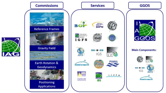
Fig. 2.2: The IAG and some of its main components: Commissions, Services, GGOS
The four commissions have as a goal to deal with several scientific topics. Commission 1 is interested in reference frames, both global and regional and its variations in time and their change due to tectonic plate motion, Earth’s rotation axis and center of mass changes. Commission 2 is promoting research in the area of the Earth’s gravity field as its change in time caused by several terrestrial and extraterrestrial reasons. Regarding the Earth as a ‘living’ planet, Commission 3 is studying the deformation of the Earth’s crust and mass transports and the results these geodynamic effects have to the Earth’s rotation and Length of Day (LOD). Finally, the last commission focuses on positioning and navigation applications. In this domain the GNSS system play an important role to support in surveying, engineering, precise navigation and Geographical Information Systems (GIS) (IAG, n.d.).
To achieve all these, the IAG is comprising various scientific services that specialize for every single domain of interest (e.g. Altimetry, Earth tides, Geoid etc.) and provides scientific products to the community. A few of these services that are cited extensively in the present thesis are: the International GNSS Service (IGS) and the International Earth Rotation and Reference Systems Service (IERS) (IAG, n.d.).
2.3 The Global Geodetic Observing System (GGOS)
The GGOS was initiated from the IAG in 2003, in order to encourage the use of geodetic applications and to provide measurements related to the Earth’s shape, rotation and gravity field, with a view to observe the Earth’s dynamic system changes. In order to do so, GGOS is
20
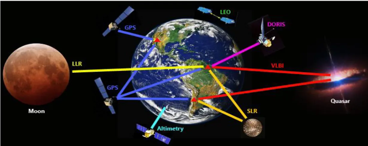
comprising several IAG services (i.e. IGS, IERS, International VLBI Service for Geodesy and Astrometry (IVS), International Laser Ranging Service (ILRS), International DORIS Service (IDS) etc.) that deliver products on a constant basis. The geodetic techniques used by the IAG services are namely space- and ground-based geodetic techniques such as: Very-Long-Baseline Interferometry (VLBI), Satellite Laser Ranging (SLR), Doppler Orbitography and Radiopositioning Integrates by Satellite (DORIS), GNSS, gravity satellite missions in Low Earth Orbits (LEO) orbits etc. (GGOS, 2016a) (IAG, n.d.). In Fig. 2.3 a graphic representation of the different space geodetic techniques is given.
Fig. 2.3: Space and Ground- geodetic techniques used by the GGOS (IAG, n.d.) The GGOS main vision is:
“to understand the dynamic Earth system by quantifying our planet’s changes in space and time” (GGOS, 2016a)
The main points of interest of the GGOS comprise (GGOS, 2016a):
▪ To furnish any observations necessary for the study of the Earth’s shape, rotation and mass distribution variations
▪ To provide the reference frame needed for any other scientific and societal purposes ▪ To benefit science and society by educating the importance of geodetic research
benefits
All these goals are categorized and divided in four GGOS focus areas (GGOS, 2016b): ▪ Geohazards
▪ Sea Level change, Variability and Forecasting ▪ Unified Height System
21
2.4 The GNSS systems
The Global Navigation Satellite Systems (GNSS) are satellite-based systems that are generally used for positioning, navigation and precise time purposes. These systems are widely used also for various other applications (transportation, military, location-based services etc.) including scientific applications (ex. geodesy, surveying, precise time synchronization etc.) (ESPI, et al., 2017). As mentioned above they contribute also to the goals of GGOS as one of the space geodetic techniques.
Until now, there are two fully operational systems: the American Global Positioning System (GPS) and the Russian GLObalnaya NAvigatsionnaya Sputnikovaya Sistema (GLONASS). These two systems are widely used even from the 1980’s. However, the global community has realized the importance of such systems: Another two systems are under development, the European Galileo and the Chinese Beidou (previously called COMPASS). Apart from those four global coverage systems there are also regional GNSS systems such as the Japanese Quasi-Zenith Satellite System (QZSS) and the Indian Regional Navigation Satellite System (IRNSS) (operational name: NAVigation with Indian Constellation (NAVIC)).
The GPS system
The GPS system is owned by the United States government and was initially developed for military purposes by the Department of Defense (DoD) in 1973. The civilian use started in the 80’s and it paved the way for many geodetic uses. Until today many generations of satellites have passed (i.e. the newest being the Block I, nowadays the modernized GPS (GPS III) satellites belong to Block III –A or F) (US Department of Transportation, 2008). The GPS geodetic reference system is the World Geodetic System 1984 (WGS-84). With respect to time reference, the GPS time scale is related to the International Atomic Time (TAI) with a constant offset of 19sec. TAI and the Universal Time Coordinated (UTC) differ by a number of seconds. The GPS is providing two kinds of services: the Standard Positioning Service (SPS), used for civilian purposes, and the Precise Positioning Service (PPS), dedicated to authorized users (Hofmann-Wellenhof, et al., 2008).
The GLONASS system
In the decade of 70’s the former Union of Soviet Socialist Republic (USSR) started the development of the GLONASS system. The completion of the system took place in 1996. It is operated by the Russian military forces and it is used mainly as a military system. In 2004, however, the Russian government decided to provide an open access for civilian purposes. Currently, GLONASS is under modernization program. The GLONASS geodetic reference frame is the PE-90 (also known in Russian as PZ-90). With respect to the time reference, the GLONASS
22
time is very closed to the UTC time with a constant offset of 3hr due to the difference between Moscow and Greenwich time (Hofmann-Wellenhof, et al., 2008).
The Galileo system
Galileo is the European GNSS system. It is developed by the European Commission (EC), the European Space Agency (ESA) and it is operated by the European GNSS Agency (GSA). The main purpose of this system is to be an open, global system of civilian use, compatible and interoperable with the GPS.
The first two satellites were the Galileo In-Orbit Validation Element (GIOVE) A and B that were test satellites (during the definition phase). In the In-Orbit Validation (IOV) phase, four experimental prototype satellites (that also carry the name IOV) where launched in orbit, in order to secure the frequency and to initially validate the system through tests (ESA, 2014). The completion of the constellation consists of the Full Operational Capability (FOC).
The European GNSS Agency declared initial services in 2016, moving from the test phase to the provision of services (GSA, 2018) (GSA, 2016). Thenext phase, the deployment phase, consists of launching the rest of the satellites and complete the ground segment. Full Operational Capability (FOC) is scheduled (at the time of this thesis publication) for 2020 with the launch of the last four satellites (ESA, 2019).
The geodetic reference frame of the Galileo system is called Galileo Terrestrial Reference Frame (GTRF) and is related to the International Reference Frame (ITRF). The Time reference is called Galileo System Time (GST) and has a constant offset to the TAI time. The difference of GPS time and GST, also called GPS to Galileo Time Offset (GGTO) is going to be distributed to the users. As of 2019, the Galileo system will provide the following services to the users (GSA, 2018):
▪ Open Service (OS) that provides positioning and timing services freely to the users. ▪ High Accuracy Service (HAS) that is an extra service complementing the OS by delivering
extra information
▪ Public Regulated Service (PRS) targeted to government-authorized users
▪ Search and Rescue Service (SAR) that is a service based on rescue alert system and it is the European participation to the COSPAS-SARSAT rescue system
The following Tab. 2.1 is showing some of the characteristics of the three GNSS systems that are studied in the present thesis (Hofmann-Wellenhof, et al., 2008).
23
GNSS System GPS GLONASS Galileo
System's logo
Origin USA Russia Europe
Constellation 6 planes Walker (24/3/1) Walker (24/3/1)
Orbital Plane Separation 60° 120° 120°
Altitude 20180km 19130km 23222km
Revolutions / Sid. Days 2 / 1 17 / 8 17 / 10
Orbital Inclination 55° 65° 56°
Semimajor Axis 26560km 25508km 29601km
Revolution period 11h 58m 11h 16m 14h 04h Main Frequencies L1 / L2 G1 / G2 E1 / E5a Time System GPS time (UTC) GLONASS time (UTC) Galileo System time Services SPS, PPS SPS, PPS OS, HAS, PRS, SAR
Geodetic Reference WGS-84 PE-90 GTRF
Number of satellites
(Aug. '20) 32 27 24
Tab. 2.1: Some characteristics for GPS, GLONASS and Galileo
2.5 The GNSS systems as a geodetic technique
The GNSS systems apart from navigation and timing applications are an important space geodetic technique. The GPS system (as it was the first completed and operational GNSS system) gave rise to the use of GPS as a geodetic technique (Bock & Melgar, 2016). It was realized that when using GPS phase measurements (of L1 and L2 frequency bands) for relative positioning of a baseline of many km, it can give mm to cm level positioning accuracy (Bossler, et al., 1980) (Remondi, 1985). This started the development of worldwide baselines and finally a global network of GPS stations in the 1980s under civilian purposes. The advantage of using such a network was the amelioration of satellite orbit precision (Bock & Melgar, 2016). Nowadays, precise GNSS positioning is possible in the order of mm to cm levels in post-processed (Precise Point Positioning (PPP), Double Differenced (DD) Positioning) and real-time modes (Real Time Kinematic (RTK)).
24
Many scientific areas take advantage of this high precision positioning capability. To name a few, some of the numerous applications are:
▪ In the area of reference systems and frames: GNSS systems contribute to the ITRF construction together with other space-geodetic techniques. They help to provide geographic density because the GNSS network is denser with respect to the other techniques (See Fig. 2.4). They can also provide access to the ITRF (Altamimi, 2018). ▪ In the area of Earth rotation studies: The GNSS systems provide information to the IERS
about Polar Motion (PM), Polar Motion Rates (PM rate) and Length-of-day (LOD). ▪ In the area of geohazards: by providing with the accurate positioning and timing
information used to detect changes in motion or surfaces e.g. for studying earthquake faults, landslides and rock falls, volcano eruptions, that can as well be used by early warning systems (i.e. in case of Tsunami incidents) etc. (GGOS, 2016c) (GGOS, 2007). ▪ In the area of sea level studies by localizing (especially in vertical land movements) tide
gauges that help gravity changes and sea level observations (GGOS, 2016d). They help to study tides, and any other seasonal and longer-term variations in water transport (Bock & Melgar, 2016).
▪ In the area of climate research: they give information about sea level rise, ice mass loss, changes in the cryosphere, ocean thermal expansion due to warming. They can contribute to the change of climate caused by anthropogenic sources: i.e. change of the land surface caused by the extraction of water, oil and minerals (Bock & Melgar, 2016). ▪ In the area of tectonic and volcano geodesy: Trough GNSS temporal series it is possible to study any crustal deformation of the solid Earth, earthquakes, glacial isostatic adjustment (GIA) due to long-term glacial retreat.
▪ In the interdisciplinary area of geodetic space weather research, they participate together with other geodetic techniques to provide information about the state of ionosphere and other atmospheric processes (GGOS, 2016e). The IGS is also delivering atmospheric products regarding the tropospheric Zenith Path Delay (ZPD) and ionospheric Total Electron Content (TEC) grid.
25
Fig. 2.4: ITRF2014 network highlighting VLBI, SLR, and DORIS sites co-located with GNSS (Altamimi, et al., 2016)
The importance of the GNSS systems has led to the creation of the United Nations (UN) initiative on Global Geospatial Information Management (UN-GGIM). The goal of this initiative is the development of global geospatial information. One of the working areas include the creation of a global geodetic reference frame (UN, 2019). Apart from this initiative the UN office for outer space affairs have their program on space applications that include goals for the GNSS systems in order to improve the overall GNSS service provision to benefit people around the world. The office supports projects related to the establishment of regional reference frame networks that will enhance applications in fields such as geodesy, mapping, surveying, geo-information, natural hazards mitigation, and earth sciences (UN, 2012). Furthermore, the role of Earth Observation (EO) and geolocation as provided from the GNSS systems is acknowledged from the UN to achieve the Sustainable Development Goals (SDGs) as defined in the 2030 Agenda for Sustainable Development (UN, 2018) (UN, n.d.).
26
2.6 The IGS Service and the MGEX
IGS
The International GNSS Service (IGS) was founded in 1994 as an IAG service (IAG, n.d.)with the goal of providing high-quality of GNSS data, products and services worldwide with open access (IGS Central Bureau, 2013). It consists of more than 220 agencies, universities and research institutions all over the world that provide their products using a global network (Fig. 2.5 & Fig. 2.6) of over 400 active monitoring stations (as of 2019) (IGS, 2010) (Kouba, 2009). It also provides an archive of measurements and analyses of previous years. These permanent monitoring stations are continuously operating providing data of different GNSS systems. The IGS is consisting of around 12 Analysis Centers (AC), an Analysis Center Coordinator (ACC) (IGS, 2017) several Geodetic networks, several Working groups and two pilot projects (IGS, 2017b).
MGEX
With the emergence of new GNSS systems in the last decade, we are brought to the Multi-GNSS era. Ergo, it became important to start using the data of all systems together for the various benefits that the hybridization of GNSS systems can bring: capabilities for more precise positioning, better coverage, end of the dependency of military systems etc. (IGS, 2011) (IGS Central Bureau, 2013).
The Multi-GNSS Experiment (MGEX) is one of the pilot projects of the IGS (IGS, 2011). It has as purpose to provide and analyze all types of GNSS signal data coming from all GNSS systems including Galileo, BeiDou, QZSS and NAVIC and the modernized GPS and GLONASS as well as SBAS systems. Several AC are participating in the MGEX project by processing and providing orbit and clock and bias products from various new GNSS systems (in addition to the initial GPS and GLONASS) on a weekly basis.
MGEX activities are currently continued as a part of the Multi-GNSS Working Group (WG) (Montenbruck, et al., 2017). The principal goals of the Multi-GNSS WG are (IGS, 2018):
▪ Transfer information essential to the IGS about the advancements of the GNSS systems ▪ To help improve the Multi-GNSS network by enabling to track the new signals from the
new GNSS systems, by advising the receiver and antenna providers
▪ To gain experience about the tracking of the new signals, and analyzing them for producing Multi-GNSS products
27 Fig. 2.5: World map of IGS stations (IGS, 2010)
28
The CNES/CLS Analysis Center
Since 2010, the Centre National d’ Etudes Spatiales (CNES) and Collecte Localisation Satellites (CLS) are an IGS AC. They participated in the past in MGEX and they are currently joining the Multi-GNSS WG. In addition, they participate in the orbit WG and in the ambiguity WG of the IGS. For these purposes, the AC provides precise GNSS orbits, clock and biases products, station coordinates and Earth orientation parameters (CNES/CLS, 2017). The Multi-GNSS products provided are including GPS, GLONASS and Galileo systems. The software used is the GINS software (Marty, 2013). It is a multi-technique (i.e. DORIS, GPS, VLBI, SLR etc.) software used for various space geodesy applications.
The team is a contribution of scientists and engineers from the space geodesy research group GRGS (Groupe de Recherche de Géodésie Spatiale) of France (GRGS, n.d.). The CLS group is a subsidiary company of CNES that contributes in localizing and collecting the satellite data. Furthermore, the CLS team is contributing to the processing of the space data for the domain of orbitography, terrestrial kinematics, space geodesy, space weather, etc.
2.7 Conclusions
Geodesy, one of the oldest branches of science, is an important contribution to understanding the Earth’s size, shape and gravity field. Space geodesy is using space-based techniques in order to contribute to this understanding. Several space geodetic methods are widely used from the geo-scientists. One of them -a quite important one- is the GNSS systems, that are used in various geodetic applications that require precise positioning and timing.
With the arrival of the new European GNSS system, it became necessary to study and check the new possibilities that such new system will bring to space geodesy: not only as a separate system under civilian use but also within a Multi-GNSS formation together with the existing GPS system (already widely used for scientific applications today).
In the following chapter we will study the GNSS types of measurements used for this study and we will explain the zero-difference ambiguity resolution method.
29
3. GNSS Measurements
3.1 Introduction
In Chapter 2 it is described the importance of the Precise GNSS positioning to geodetic and scientific applications. As a consequence, there is a great scientific interest of the CNES/CLS IGS AC to examine the future positioning capabilities of the European GNSS system. However, the Galileo constellation is yet to be complete. In the beginning of the present thesis (November 2016) the Galileo constellation was comprising of 7 operational satellites and 2 satellites in elliptical orbits and by the end (October 2019) it was only 4 satellites away to the full constellation (i.e. 22 operational satellites and 2 satellites in elliptical orbit)(See Fig. 3.1). This made it questionable whether the uncompleted Galileo constellation alone at that time was sufficient to provide mm level positioning accuracy. One necessary and important step was to calculate precise Galileo Orbits within a Multi-GNSS formation together with GPS. The reason for adding the GPS constellation was decided so that Galileo can take advantage of the precise GPS orbits; having more common satellite passes per station, better connectivity, solving for common station errors and parameters (i.e. tropospheric delay, receiver clock delay etc.). It is clear that the more precise the satellite orbits are (as reference), the better positioning accuracy it can be achieved.
30
In this chapter they are described the basic GNSS observations used for geodesy. It is presented the problem of carrier phase ambiguities and the method used already from CNES/CLS AC for resolving the GPS phase ambiguities. This method is currently applied from the AC both for Precise Orbit Determination (POD) and Precise Point Positioning (PPP) for the GPS system.
3.2 GNSS observations used for Geodesy
The GNSS observations used for geodesy are mainly of two types: the pseudorange (or code or range) measurement and the carrier phase (or phase) measurement1 (Hofmann-Wellenhof, et al., 2008). The equation model bellow is given for the pseudorange (code) and carrier phase measurements for two frequencies 𝑖 and 𝑗:
𝑃𝑟,𝑖𝑠 = 𝜌 𝑟𝑠+ 𝑐𝛥𝑡 + 𝑇𝑟𝑠+ 𝐼𝑟𝑠 + 𝑏𝑖𝑠+ 𝑏𝑟,𝑖+𝐸𝑟,𝑖𝑠 (3.1) 𝑃𝑟,𝑗𝑠 = 𝜌 𝑟𝑠 + 𝑐𝛥𝑡 + 𝑇𝑟𝑠+ 𝑓𝑖2 𝑓𝑗2𝐼𝑟𝑠+ 𝑏𝑗𝑠+ 𝑏𝑟,𝑗+ 𝐸𝑟,𝑗𝑠 (3.2) 𝐿𝑟,𝑖𝑠 = 𝜆 𝑖𝜑𝑟,𝑖𝑠 = 𝜌𝑟𝑠+ 𝑐𝛥𝑡 + 𝑇𝑟𝑠− 𝐼𝑟𝑠+ 𝜆𝑖𝛮𝑟,𝑖𝑠 + 𝜆𝑖𝑊𝑟𝑠+ 𝛽𝑖𝑠+ 𝛽𝑟,𝑖 + 𝜀𝑟,𝑖𝑠 (3.3) 𝐿𝑟,𝑗𝑠 = 𝜆 𝑗𝜑𝑟,𝑗𝑠 = 𝜌𝑟𝑠 + 𝑐𝛥𝑡 + 𝑇𝑟𝑠− 𝑓𝑖2 𝑓𝑗2𝐼𝑟𝑠+ 𝜆𝑗𝛮𝑟,𝑗𝑠 + 𝜆𝑗𝑊𝑟𝑠+ 𝛽𝑗𝑠+ 𝛽𝑟,𝑗 + 𝜀𝑟,𝑗𝑠 (3.4) with:
𝑃𝑟,𝑖𝑠 , 𝑃𝑟,𝑗𝑠 : code measurements at receiver 𝑟 from satellite 𝑠 on frequency 𝑖 or 𝑗 [m] 𝐿𝑠𝑟,𝑖 , 𝐿𝑟,𝑗𝑠 : phase measurements at receiver 𝑟 from satellite 𝑠 on frequency 𝑖 or 𝑗 [m]
𝜌𝑟𝑠 : geometric distance between receiver 𝑟 and satellite 𝑠 [m] (Phase Center Offset (PCO) included). 𝜌𝑟𝑠 = √(𝑥𝑟− 𝑥𝑠)2+ (𝑦𝑟− 𝑦𝑠)2+ (𝑧𝑟− 𝑧𝑠)2 𝛥𝑡 : clock corrections of the satellite (𝛿𝑡𝑠) and the receiver (𝛿𝑡𝑟) with respect
to the synchronization to the GNSS time [s]. 𝛥𝑡 = 𝛿𝑡𝑟− 𝛿𝑡𝑠
1 The zero-difference ambiguity fixing method is based originally on the Laurichesse-Mercier model of equations for code (𝑃𝑖 and 𝑃𝑗) and carrier phase (𝐿𝑖 and 𝐿𝑗) (Laurichesse, et al., 2009). This model of equations is written in
such a way that stochastic parameters (ionosphere-free phase and pseudorange clocks) are separated from the clock parameters, that are affected by long-term variations. Furthermore, the term for the geometric propagation distance is including the tropospheric delay and relativistic effects (Laurichesse, et al., 2009). In the present thesis,
31
𝑇𝑟𝑠 : tropospheric signal delay [m] that depends on the temperature, pressure, and humidity along the signal path through the troposphere
𝐼𝑟𝑠 : ionospheric signal delay [m] caused by change in the propagation speed of the GNSS signal when passing through the ionospheric layer2
𝐸𝑟,𝑖𝑠 , 𝐸𝑟,𝑗𝑠 : code measurement noise at receiver 𝑟 from satellite 𝑠 on frequency 𝑖 or 𝑗 [m] ~ 𝕆 (1m). This term is including all sources of code errors: e.g.
multipath
𝑓𝑖 , 𝑓𝑗 : carrier frequency 𝑖 or 𝑗 [Hz]
𝑐 : speed of light in vacuum [m/s]
𝜆𝑖 , 𝜆𝑗 : nominal wavelength of the carrier frequency 𝑖 or 𝑗 [m] 𝜑𝑟,𝑖𝑠 , 𝜑
𝑟,𝑗𝑠 : carrier phase measurement at receiver 𝑟 from satellite 𝑠 on frequency 𝑖 or 𝑗 [cycles]
𝛮𝑟,𝑖𝑠 , 𝛮
𝑟,𝑗𝑠 : integer carrier phase ambiguity at receiver 𝑟 from satellite 𝑠 on frequency 𝑖 or 𝑗
𝑊𝑟𝑠 : carrier phase wind up effect [cycles] 𝑏𝑠 , 𝑏
𝑟 : code phase biases of satellite and receiver [m] 𝛽𝑠 , 𝛽
𝑟 : carrier phase biases of satellite and receiver [m] 𝜀𝑟,𝑖𝑠 , 𝜀
𝑟,𝑗𝑠 : carrier phase measurement noise at receiver 𝑟 from satellite 𝑠 on frequency 𝑖 or 𝑗 [m] ~ 𝕆 (1mm). This term is including all sources of code errors: multipath, etc.
The difference of these two types of GNSS measurements are extensively discussed in numerous publications ( (Hofmann-Wellenhof, et al., 2008), (ESA, et al., 2013), (Verhagen, 2005) etc.). It is important to note, however, that the pseudorange measurement is accurate but not precise whereas the carrier phase measurement is precise but not accurate; this is because of the integer ambiguity term that is unknown. The ambiguity term is introducing a bias that needs to be determined. This bias can be determined either as a real number or an integer number. The process of calculating the bias an as integer number is called integer ambiguity resolution and it has been a major research topic over the past decades.
2 The ionosphere speeds up the propagation of the carrier phase beyond the speed of light, while it slows down
32
3.3 Integer Ambiguity Resolution
When using the carrier phase measurements, there is a bias that is related to the integer number of the past cycles (ambiguous term). There are many methods published worldwide over many years that deal to estimate this integer number (Verhagen, 2005). After the resolution of the integer ambiguity bias, the phase measurement can be used as a both precise and accurate GNSS measurement.
Fixing GNSS phase ambiguities to their integer values is known to be the key to access the highest accuracy. It is an essential step that is used both when doing satellite POD, positioning or any other precise positioning application. The general procedure requires basically three steps. Firstly, an estimation of the so-called float solution is calculated, when the ambiguity is estimated as a real (ℝ) number. Secondly, a type of transformation from ℝ to integer (ℕ) is applied. There are multiple methods for this step (i.e. nearest integer rounding, integer bootstrapping, integer least-squares etc.) (Verhagen, 2005). At the end, after the ambiguity resolution procedure, phase measurements are corrected and the estimation of the remaining parameters of interest is done again.
This complicated problem has generally two main approaches. The historical one is based on the double-differencing of raw observations between pairs of satellites and pairs of receivers. In the last decade, various authors have demonstrated the success of strategies based on the zero-difference (or undifferenced) GPS observations (Mercier & Laurichesse, 2007) (Ge, et al., 2008) (Banville, et al., 2008).
The following graph (Fig. 3.2) is showing an example of the improvement of the CNES/CLS AC final GPS orbit product (GRG) when the ambiguity resolution (AR) started to be applied (starting at GPS week 1555). The graph is showing the smoothed weighted RMS of all IGS ACs GPS final orbit solutions compared to the IGS final orbits between GPS week 700 (07/06/1993) and GPS week 2050 (26/04/2019). After applying ambiguity resolution, the weighted RMS dropped from 35 mm to 20 mm.
33
Fig. 3.2: The benefit of the ambiguity fixing for the GPS final orbits from the GRG AC (IGS, 2019). In the beginning of the present thesis the CNES/CLS AC was already delivering Galileo float orbit products (i.e. without ambiguity resolution). The quality of Galileo float orbit modelling at that time resembled the quality of GPS float orbits before the start of the ambiguity fixing algorithm application; around 10-20 cm RMS from orbit overlaps. This gave the idea that efforts should be made to perform Galileo ambiguity resolution respectively. After the successful ambiguity resolution, Galileo orbits would be more precise.
Up until recently, there are some efforts of Galileo ambiguity fixing using the double-difference method. The German Aerospace Center (Deutsches Zentrum für Luft- und Raumfahrt e.V - DRL) has tested the success rate of ambiguity resolution for the Galileo constellation until 2016. It has been found that the percentage of ambiguity resolution depends on the number of available satellites and it can reach above 90% (Steigenberger & Montenbruck, 2016). The Helmholtz Centre Potsdam GFZ German Research Centre for Geosciences (GFZ) has studied Galileo ambiguity fixing for the IOV satellites using a combined GPS/Galileo method of Ge, et al. (2005) showing a percentage of about 85% success rate for Galileo ambiguity fixing (Uhlemann, et al., 2016). Nevertheless, it is a new topic to apply the zero-difference ambiguity resolution method to the Galileo system.
34
3.4 Zero-difference Ambiguity Resolution Method
In the following subchapter it is described the zero-difference ambiguity resolution method that is already used from the CNES/CLS AC for the GPS system. Basically, this method is divided in two steps:
▪ The Wide-Lane ambiguity fixing ▪ The Narrow-Lane ambiguity fixing
With the definition of the wide-lane combination, it is meant that the combined wavelength is larger than the largest individual wavelength in the combination. In the same way, the narrow-lane combination, which have a shorter wavelength than the individual signal with the shortest wavelength in the combination (Teunissen & Montenbruck, 2017).
Wide-Lane ambiguity fixing
From the Eq.3.1 to 3.4, the Wide-Lane (WL) linear combinations for code (𝑃𝑊𝑟𝑠) and carrier phase (𝐿𝑊𝑟𝑠) and the Narrow-Lane (NL) linear combinations for code (𝑃𝑁𝑟𝑠) and carrier phase (𝐿𝑁𝑟𝑠) are defined as:
𝑃𝑊𝑟𝑠 = 𝑓𝑖 𝑓𝑖− 𝑓𝑗𝑃𝑟,𝑖 𝑠 − 𝑓𝑗 𝑓𝑖 − 𝑓𝑗𝑃𝑟,𝑗 𝑠 (3.5) 𝐿𝑊𝑟𝑠 = 𝑓𝑖 𝑓𝑖 − 𝑓𝑗𝐿𝑠𝑟,𝑖− 𝑓𝑗 𝑓𝑖− 𝑓𝑗𝐿𝑠𝑟,𝑗 (3.6) 𝑃𝑁𝑟𝑠 = 𝑓𝑖 𝑓𝑖 + 𝑓𝑗𝑃𝑟,𝑖 𝑠 + 𝑓𝑗 𝑓𝑖+ 𝑓𝑗𝑃𝑟,𝑗 𝑠 (3.7) 𝐿𝑁𝑟𝑠 = 𝑓𝑖 𝑓𝑖+ 𝑓𝑗𝐿𝑠𝑟,𝑖 + 𝑓𝑗 𝑓𝑖 + 𝑓𝑗𝐿𝑠𝑟,𝑗 (3.8)
With the corresponding WL wavelength (𝜆𝑤𝑙) and NL wavelength (𝜆𝑛𝑙) as:
𝜆𝑤𝑙 = 𝑐 (𝑓⁄ 𝑖 − 𝑓𝑗)= 𝜆𝑖𝜆𝑗⁄(𝜆𝑗 − 𝜆𝑖) (3.9)
𝜆𝑛𝑙 = 𝑐 (𝑓⁄ 𝑖+ 𝑓𝑗)= 𝜆𝑖𝜆𝑗⁄(𝜆𝑖+ 𝜆𝑗) (3.10)
The following table Tab. 3.1 gives the wide-lane and the narrow-lane wavelengths for GPS and Galileo for some combinations of their basic frequencies:
35 GNSS Frequency 𝜆𝑤𝑙 [m] 𝜆𝑛𝑙 [cm] GPS (𝐿1, 𝐿2) 0.862 10.7 GPS (𝐿1, 𝐿5) 0.751 10.9 GPS (𝐿2, 𝐿5) 5.861 12.5 Galileo (𝐸1, 𝐸5𝑎) 0.751 10.9 Galileo (𝐸1, 𝐸5𝑏) 0.814 10.8 Galileo (𝐸5𝑎, 𝐸5𝑏) 9.768 12.6
Tab. 3.1: Table of values for wide-lane and narrow-lane wavelength for GPS and Galileo The noise amplification factors3 for the wide-lane (𝜎
𝑤𝑙) and the narrow-lane (𝜎𝑛𝑙) become (Teunissen & Montenbruck, 2017):
𝜎𝑃𝑤𝑙 = √ 𝑓𝑖 2 (𝑓𝑖− 𝑓𝑗)2𝜎𝑃𝑖 2 + 𝑓𝑗 2 (𝑓𝑖 − 𝑓𝑗)2𝜎𝑃𝑗 2 (3.11) 𝜎𝑃𝑛𝑙 = √ 𝑓𝑖 2 (𝑓𝑖 + 𝑓𝑗)2𝜎𝑃𝑖 2 + 𝑓𝑗 2 (𝑓𝑖 + 𝑓𝑗)2𝜎𝑃𝑗 2 (3.12) 𝜎𝐿𝑤𝑙 = √ 𝑓𝑖 2 (𝑓𝑖 − 𝑓𝑗)2𝜎𝐿𝑖 2 + 𝑓𝑗 2 (𝑓𝑖− 𝑓𝑗)2𝜎𝐿𝑗 2 (3.13) 𝜎𝐿𝑛𝑙 = √ 𝑓𝑖2 (𝑓𝑖+ 𝑓𝑗) 2𝜎𝐿𝑖2 + 𝑓𝑗2 (𝑓𝑖+ 𝑓𝑗) 2𝜎𝐿𝑗2 (3.14) were:
𝜎𝑃𝑤𝑙 , 𝜎𝐿𝑤𝑙 : wide-lane noise for code and carrier [m]
𝜎𝑃𝑛𝑙 , 𝜎𝐿𝑛𝑙 : narrow-lane noise for code and carrier [m]
𝜎𝑃𝑖 , 𝜎𝑃𝑗 : code noise for frequency 𝑖 or 𝑗 [m]
𝜎𝐿𝑖 , 𝜎𝐿𝑗 : carrier noise for frequency 𝑖 or 𝑗 [m]
Assuming that the noise is identical regardless of the frequency, the terms are substituted for the code noise (𝜎𝑃) and the carrier noise (𝜎𝐿):
36 𝜎𝑃𝑤𝑙 = √𝑓𝑖 2+ 𝑓 𝑗2 (𝑓𝑖− 𝑓𝑗)2𝜎𝑃 (3.15) 𝜎𝑃𝑛𝑙 = √𝑓𝑖 2+ 𝑓 𝑗2 (𝑓𝑖 + 𝑓𝑗)2𝜎𝑃 (3.16) 𝜎𝐿𝑤𝑙 = √ 𝑓𝑖2+ 𝑓𝑗2 (𝑓𝑖 − 𝑓𝑗)2𝜎𝐿 (3.17) 𝜎𝐿𝑛𝑙 = √ 𝑓𝑖2+ 𝑓𝑗2 (𝑓𝑖+ 𝑓𝑗) 2𝜎𝐿 (3.18)
From these expressions it is possible to calculate the amplification factor for noise of the wide-lane and the narrow-wide-lane combinations. The results are given in the following table Tab. 3.2. It is worth noticing that the amplification factor for the narrow-lane combinations is similar for any combination of frequencies.
GNSS Frequency 𝐴𝑤𝑙 𝐴𝑛𝑙 GPS (𝐿1, 𝐿2) 5.74 0.71 GPS (𝐿1, 𝐿5) 4.93 0.71 GPS (𝐿2, 𝐿5) 33.24 0.71 Galileo (𝐸1, 𝐸5𝑎) 4.93 0.71 Galileo (𝐸1, 𝐸5𝑏) 5.39 0.71 Galileo (𝐸5𝑎, 𝐸5𝑏) 54.92 0.71
Tab. 3.2: Table of values for wide-lane and narrow-lane noise amplification factors
From the Eq. 3.6 and 3.7 it is possible to form a Melbourne-Wübbena (MW) linear combination that is the difference of wide-lane carrier combination and narrow-lane code combination. It has the identity to cancel out any geometric, first-order ionospheric effects, clock and phase wind up terms (Melbourne, 1985) (Wübbena, 1985). It is a useful combination to detect cycle slips. For periods with no cycle slips this combination shows a constant value:
𝑀𝑊𝑟𝑠 = 𝜆𝑤𝑙𝜑𝑟𝑠 = 𝐿𝑊𝑟𝑠− 𝑃𝑁𝑟𝑠 = = ( 𝑓𝑖 𝑓𝑖− 𝑓𝑗𝐿𝑟,𝑖 𝑠 − 𝑓𝑗 𝑓𝑖 − 𝑓𝑗𝐿𝑟,𝑗 𝑠 ) − ( 𝑓𝑖 𝑓𝑖+ 𝑓𝑗𝑃𝑟,𝑖 𝑠 + 𝑓𝑗 𝑓𝑖 + 𝑓𝑗𝑃𝑟,𝑗 𝑠 ) (3.19)
37 Which can further be written:
𝑀𝑊𝑟𝑠 = 𝜆 𝑤𝑙𝜑𝑟𝑠 = 𝜆𝑤𝑙(𝛮𝑟,𝑖𝑠 − 𝛮𝑟,𝑗𝑠 ) + 𝑀𝑊(𝑏𝑠, 𝛽𝑠) + 𝑀𝑊(𝑏𝑟,𝛽𝑟) ≈ 𝜆𝑤𝑙(𝛮𝑟,𝑖𝑠 − 𝛮 𝑟,𝑗𝑠 − 𝜇𝑠(𝑡) + 𝜇𝑟(𝑡)) ≈ 𝜆𝑤𝑙(𝛮𝑤𝑙,𝑟𝑠 − 𝜇𝑠(𝑡) + 𝜇 𝑟(𝑡)) (3.20) where:
𝑀𝑊𝑟𝑠 : Melbourne-Wübbena linear combination at receiver 𝑟 from satellite 𝑠 [m]
𝜆𝑤𝑙 : WL wavelength [m]
𝛮𝑤𝑙,𝑟𝑠 : WL ambiguity between receiver 𝑟 and satellite 𝑠. 𝛮
𝑤𝑙,𝑟𝑠 = 𝛮𝑟,𝑖𝑠 − 𝛮𝑟,𝑗𝑠 𝜇𝑠(𝑡) : delay coming from the satellite (also known in the bibliography as WL
satellite bias - WSB). This bias is the result of other biases combined from Eq. 3.1 to 3.4.
𝜇𝑟(𝑡) : delay coming from the receiver (also known in the bibliography as WL receiver bias - WRB). This bias is the result of other biases combined from Eq. 3.1 to 3.4
The combined noise from the MW linear combination can be formulated as:
𝜎𝑀𝑊 = √
𝑓𝑖2+ 𝑓𝑗2
(𝑓𝑖− 𝑓𝑗)2𝜎𝐿 + √
𝑓𝑖2+ 𝑓𝑗2
(𝑓𝑖+ 𝑓𝑗)2𝜎𝑃 (3.21)
By inserting some exemplary values for code (e.g. 0.5m) and carrier phase noise (e.g. 3mm) the following magnitude of MW noise is given in table Tab. 3.3:
GNSS Frequency MW noise [m] GPS (𝐿1, 𝐿2) 0.37 GPS (𝐿1, 𝐿5) 0.37 GPS (𝐿2, 𝐿5) 0.45 Galileo (𝐸1, 𝐸5𝑎) 0.37 Galileo (𝐸1, 𝐸5𝑏) 0.37 Galileo (𝐸5𝑎, 𝐸5𝑏) 0.52 Tab. 3.3: Exemplary noise of MW combinations
It is noticed that the noise magnitude of the MW is nearly half of a wide-line wavelength (Refer to both Tab. 3.1 and Tab. 3.3). This means that it is possible to resolve the wide-lane ambiguities. This is also the reason why the MW linear combination is extensively used for carrier phase AR. The trade-off however, is a large noise that is given by the code noise.
38
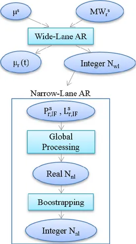
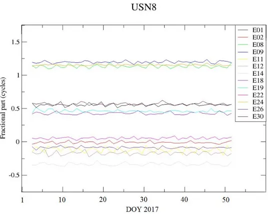
As it is clearly seen from the Eq. 3.20, the terms 𝛮𝑤𝑙,𝑟𝑠 , 𝜇𝑠(𝑡) and 𝜇𝑟(𝑡) are totally correlated. It has been observed that for the GPS system the 𝜇𝑠(𝑡) biases are stable and can be considered as constant during at least one day (Mercier & Laurichesse, 2007). Therefore, they are considered not time dependent in this formulation. This identity made possible the decorrelation of the 𝜇𝑠 from the others. Normally for the GPS system, the 𝜇𝑠 is known from the previous day value (i.e. is calculated and provided from the CNES/CLS AC to the users) (See Fig. 3.3).
Fig. 3.3: GPS 𝜇𝑠 values from July 2016 until July 2018
In order to be able to separate the 𝜇𝑟(𝑡) from the 𝛮𝑤𝑙,𝑟𝑠 and thus solve for the WL ambiguity, an estimation has to be done. The knowns parameters are the MW observations and the estimated parameters are the 𝛮𝑤𝑙,𝑟𝑠 and 𝜇𝑟(𝑡).
The above processing is done for each station individually. The result is the WL ambiguities resolution.
39
Narrow-Lane ambiguity fixing
Once the 𝛮𝑤𝑙,𝑟𝑠 is known, the following step is to form an ionosphere-free (IF) linear combination. These combinations use the equations in the two frequencies where they apply to them a coefficient: 𝛼𝑖 to thefrequency 𝑖 and 𝛼𝑗 to the frequency 𝑗 respectively. This type of linear combination contains geometry, clock corrections, troposphere corrections and, for carrier phase IF, the phase ambiguities.
𝛼𝑖 = 𝑓𝑖2 𝑓𝑖2 − 𝑓 𝑗2 (3.22) 𝛼𝑗 = −𝑓𝑗2 𝑓𝑖2 − 𝑓 𝑗2 (3.23)
where the following are valid:
𝛼𝑖+ 𝛼𝑗 = 1 (3.24)
𝛼𝑖+ 𝛼𝑗𝑓𝑖
2
𝑓𝑗2 = 0 (3.25)
Using the above coefficients, the ionosphere-free linear combinations for code and carrier phase become: 𝑃𝑟,𝐼𝐹𝑠 = 𝛼 𝑖𝑃𝑟,𝑖𝑠 + 𝛼𝑗𝑃𝑟,𝑗𝑠 = 𝜌𝑟𝑠 + 𝑐𝛥𝑡 + 𝑇𝑟𝑠+𝐸𝑟,𝐼𝐹𝑠 (3.26) 𝐿𝑠𝑟,𝐼𝐹 = 𝛼 𝑖𝐿𝑠𝑟,𝑖 + 𝛼𝑗𝐿𝑠𝑟,𝑗 = (3.27) = 𝜌𝑟𝑠+ 𝑐𝛥𝑡 + 𝑇 𝑟𝑠+𝑓 𝑐 𝑖2−𝑓𝑗2(𝑓𝑖𝛮𝑟,𝑖 𝑠 − 𝑓 𝑗𝛮𝑟,𝑗𝑠 ) +𝑓 𝑐 𝑖2−𝑓𝑗2(𝑓𝑖𝑊𝑟 𝑠− 𝑓 𝑗𝑊𝑟𝑠)+𝜀𝑟,𝐼𝐹𝑠 = = 𝜌𝑟𝑠+ 𝑐𝛥𝑡 + 𝑇𝑟𝑠+ 𝜆𝑛𝑙𝛮𝑟,𝑖𝑠 +𝜆𝑛𝑙𝜆𝜆𝑗𝑤𝑙𝛮𝑤𝑙,𝑟𝑠 +𝜆𝑛𝑙𝑊𝑟𝑠+ 𝜀𝑟,𝐼𝐹𝑠 with:
𝑃𝑟,𝐼𝐹𝑠 : ionosphere-free code measurement at receiver 𝑟 from satellite 𝑠 [m] 𝐸𝑟,𝐼𝐹𝑠 : ionosphere-free code measurement noise at receiver 𝑟 from satellite 𝑠
[m]
𝐿𝑠𝑟,𝐼𝐹 : ionosphere-free carrier measurement at receiver 𝑟 from satellite 𝑠 [m] 𝜀𝑟,𝐼𝐹𝑠 : ionosphere-free carrier measurement noise at receiver 𝑟 from satellite 𝑠
[m]