Faculté des Sciences Exactes et des Sciences de la Nature et de la Vie Département d’Informatique
THESE
Présentée pour obtenir le grade de
DOCTORAT EN SCIENCE EN INFORMATIQUE Par
Amina Bouguetitiche
THEMEModélisation des environnements virtuels urbains dédiés à
la simulation du mouvement des piétons.
Modelling virtual urban environments dedicated to the simulation of
pedestrian movement.
Soutenue le: 05/10/2020
Devant le jury composé de:
Pr. NourEddine Djedi Université de Biskra Président
Pr. Foudil Cherif Université de Biskra Rapporteur
Dr. Fabrice Lamarche Université de Rennes Co-Rapporteur
Pr. Kadi Bouatouch Université de Rennes Examinateur
Pr. Med Chaouki Babahenini Université de Biskra Examinateur
Although simulating pedestrian’s movement in urban environment is a challenging task, it has attracted the interest of researchers of different fields. In the urban planning context, movement simulation is used in the optimization of city design for ease of wayfinding and prediction of movement patterns. In wireless communication domain, predicted mobility patterns became crucial in network management optimization, allocation of critical resources and development of assisted navigation technologies. However, a realistic simulation of pedestrian wayfinding behaviour requires not only a precise modelling of human decision making process regarding strategies and heuristics applied, but also an efficient description of the spatial environment.
We propose, in this thesis, a virtual urban environment model enriched by the information needed to produce realistic pedestrian movement simulation. This model describes the geometry, topology, and spatial configuration of the simulation environment. We also provide a path planning model that takes advantage of the enriched description of the environment to make virtual pedestrians show a certain behavioural realism, especially concerning their applied strategies and route choices, which are strongly affected by their familiarity with this environment. Therefore, we propose to endow each entity with a mental representation. However, our model allows creating and simultaneously managing many entities with low costs. All proposed models are inspired from spatial cognition and space syntax domains in order to achieve naturally pedestrian navigation.
Keywords: Wayfinding behaviour; mental map; modelling virtual environment; autonomous
Résumé
Bien que la simulation du comportement de navigation des piétons en milieu urbain soit une tâche difficile, elle a suscité l'intérêt des chercheurs de différents domaines. Dans le contexte de l'urbanisme, la simulation du mouvement des piétons est utilisée dans l'optimisation de la conception des villes pour faciliter la recherche de chemin et la prédiction des mouvements. Dans le domaine de la communication sans fil, les modèles de mobilité prédits sont devenus cruciaux dans l'optimisation de la gestion du réseau, l'allocation des ressources critiques et le développement des technologies de navigation assistée. Cependant, une simulation réaliste du comportement de recherche de chemin des piétons nécessite non seulement une modélisation précise du processus décisionnel humain en ce qui concerne les stratégies et les heuristiques appliquées, mais également une description efficace de l'environnement.
Nous proposons, dans cette thèse, un modèle d'environnement virtuel urbain enrichi par les informations nécessaires pour produire une simulation réaliste des mouvements de piétons. Ce modèle décrit la géométrie, la topologie et la configuration spatiale de l'environnement de simulation. Nous proposons également un modèle de planification de chemin qui tire parti de la description enrichie de l’environnement, pour faire en sorte que les piétons virtuels manifestent un certain réalisme comportemental, notamment en ce qui concerne les stratégies de navigation appliquées et les choix d’itinéraire, fortement influencés par leur familiarité avec cet environnement. Nous proposons donc de doter chaque entité d’une représentation mentale. Cependant, notre modèle permet de créer et de gérer simultanément de nombreuses entités à faibles coûts. Tous les modèles proposés sont inspirés des domaines de la cognition spatiale et de la syntaxe spatiale afin de permettre une navigation naturelle des piétons.
Mots-clés: recherche de chemin; carte mentale; modélisation d’environnement virtuel; agent autonome ; syntaxe spatiale; sciences cognitives; environnement urbain.
صخلم
بذتجا دق هنأ لاإ ، ةبعص ةمهم لثمي ةيرضحلا ةئيبلا يف ةاشملل ريسلا ةكرح ةاكاحم نأ نم مغرلا ىلع
لا طيطختلا قايس يف .تلااجملا فلتخم يف نيثحابلا مامتها
ريسلا ةكرح ةاكاحم مادختسا متي ، يرضح
كرحتلا ةيلمع ليهستل كلذو ةنيدملا ميمصت نيسحت يف
اهلخاد
ةفاضلإاب
لاجم يف .ةكرحلا طامنأ عقوتل
صيصختو تاكبشلا ةرادإ نيسحت يف ةيرورض ةعقوتملا ةكرحلا طامنأ تحبصأ ، ةيكلسلالا تلااصتلاا
لا ةحلاملا تاينقت ريوطتو ةيويحلا دراوملا
ديدحت كولسل ةيعقاولا ةاكاحملا نإف ، كلذ عمو .ةدعاسم
تايجيتارتسلااب قلعتي اميف يناسنلإا رارقلا عنص ةيلمعل ةقيقدلا ةجذمنلا طقف بلطتت لا ةاشملا تاراسم
.ةيناكملا ةئيبلل ًلااعف اًفصو اًضيأ نكلو ، ةقبطملا قرطلاو
،حرتقن
هذه يف
،ةحورطلأا
ةيضارتفا ةيرضح ةئيب جذومن
ةاكاحم جاتنلإ ةمزلالا تامولعملاب ةينغ
.ةاكاحملا ةئيبل يناكملا نيوكتلاو ، ايجولوبوطلا ، ةسدنهلا جذومنلا اذه فصي .ةاشملا ةكرحل ةيعقاو
يرثلا فصولا نم ديفتسي راسملا طيطختل اًجذومن مدقن كلذ ىلإ ةفاضلإاب
،ةئيبلل
ةاشملا لعجل
نييضارتفلاا
راسملا تارايخو ةقبطملا ةحلاملا تايجيتارتساب قلعتي اميف ةصاخ ، يعقاو كولس نورهظي
ب مهتفرعمب ةدشب رثأتت يتلا
هذه
.ةئيبلا
كلذل
عمو .ينهذ ليثمتب نايك لك ديوزت حرتقن
،كلذ
انجذومن نإف
ةضفخنم ةفلكتب دحاو تقو يف تانايكلا نم ديدعلا ةرادإو ءاشنإب حمسي
.
جذامنلا عيمج
ةاحوتسم ةحرتقملا
و يناكملا كاردلإا تلااجم نم
ءاضفلل يبيكرتلا ءانبلا
.ةاشملل ةيعيبطلا ةحلاملا قيقحت لجأ نم
:ثحبلا تاملك
ءانب ؛ يتاذ مكحت وذ ليكو ؛ةيضارتفا ةئيب ةجذمن ؛ةينهذلا ةطيرخلا ؛ راسم نع ثحبلا
.ةيرضحلا ةئيبلا ؛ةيفرعملا مولعلا ؛ءاضفلل يبيكرت
Acknowledgements
First and foremost, I would like to express my gratitude to my supervisor, Pr. Foudil Cherif. Without his encouragement, guidance, support and patience, this thesis would not exist. My sincere thanks are extended also to my second supervisor, Dr. Fabrice Lamarche for all the feedback, suggestions, and discussions.
I also gratefully acknowledge jury members: Prof. Kadi Bouatouche, Prof. NourEddine Djedi, Prof. Mohamed Chaouki Babahenini and Prof. KamelEddine Melkemi for accepting to evaluate this work.
My thanks go to my colleagues at the computer science department of the University of Biskra. I am grateful for those who helped me. I sincerely thank them all for their support. I am also grateful to all of my dear friends. I sincerely appreciate their friendships, which have brought different meanings to my life.
Finally, I would like to express my deepest gratitude to a few very special people - my parents for the encouragement. They always trusted me, and I always tried to make them proud of being my parents. Last, but not least, I would like to thank my husband for his patience, support and love during the stressful period of producing this thesis. Thank you for everything.
Content
List of figures ... IX List of tables ... XIV
General Introduction ...1
Part I State of the art ...6
Chapter I Human movement ...7
I.1 Introduction ...7
I.2 Human movement, navigation and wayfinding ...7
I.2.1 Human movement ...7
I.2.2 Wayfinding ...8
I.2.3 Taxonomy of wayfinding tasks ...9
I.3 Mental representation of space ... 10
I.3.1 Conceptualisation of Space ... 11
I.3.2 Scale of environment ... 11
I.3.3 Development of cognitive maps ... 12
I.3.4 Graph-based models of space ... 14
I.3.5 Hierarchical Structure of Spatial Mental Representations ... 14
I.3.6 Experiential Hierarchies ... 14
I.4 Spatial reasoning and decision making ... 14
I.4.1 Spatial cognition... 15
I.4.2 Individual differences in the human wayfinding decision making process ... 15
I.4.3 Mechanisms, strategies and heuristics of route planning ... 16
I.4.4 Decision levels ... 18
I.4.5 Perception of distance... 20
I.4.6 Factors influencing wayfinding ... 20
I.4.7 Synthesis ... 23
II.2 Space syntax theory ... 25
II.3 Space syntax environmental model ... 26
II.3.1 Space representation ... 26
II.3.2 Distance ... 31
II.3.3 Notion of scale ... 31
II.4 Spatial configuration ... 31
II.4.1 Space configuration analysis ... 32
II.4.2 Basic syntactic measures ... 33
II.4.3 Isovist analysis ... 35
II.4.4 Angular analysis ... 36
II.4.5 Main application and objectives of space syntax analysis ... 36
II.5 Space syntax and wayfinding ... 38
II.5.1 Space of navigation ... 38
II.5.2 Movement patterns prediction ... 38
II.5.3 Models of motion flow prediction... 39
II.5.4 Movement pattern characteristics ... 41
II.5.5 Movement simulation architectures based on space syntax ... 42
II.6 Conclusion ... 43
Chapter III Modelling pedestrian movement ... 45
III.1 Introduction ... 45
III.2 Approaches used to model pedestrian movements ... 45
III.2.1 Macroscopic models ... 45
III.2.2 Microscopic Models ... 46
III.3 Environmental Modelling ... 48
III.3.1 Spatial decomposition ... 48
III.3.2 Topological and semantic abstraction ... 54
III.3.3 Informed Environment ... 55
III.3.4 Virtual geographic environment ... 56
III.4 Cognitive maps ... 58
III.4.1 Multi-Hierarchical Semantic Maps ... 58
III.5.1 Path planning algorithms ... 62
III.5.2 Hierarchical Path Planning ... 64
III.5.3 Multiple criteria path planning ... 65
III.6 Conclusion ... 67
Discussion ... 69
Part II Contributions ... 73
Introduction ... 74
Chapter IV Virtual environment model and mental map model for pedestrian movement simulation 75 IV.1 Introduction ... 75
IV.2 Proposed approach ... 75
IV.3 Informed virtual environment graph ... 76
IV.3.1 Input Data Selection ... 77
IV.3.2 Spatial decomposition ... 78
IV.3.3 Topological abstraction ... 80
IV.3.4 Informed graph ... 82
IV.4 Mental map model ... 85
IV.4.1 Mental map structure ... 86
IV.4.2 The mental map construction approach ... 87
IV.4.3 Quantifying street prominence ... 89
IV.4.4 The process of construction of the mental map ... 91
IV.5 Conclusion ... 94
Chapter V Simulation model of the pathfinding behaviour in familiar and unfamiliar environments 95 V.1 Introduction ... 95
V.2 The pathfinding module ... 95
V.3 Access to environnemental information ... 96
V.3.1 Direct perception ... 97
V.3.2 Access to the mental map ... 98
V.4 Path planning algorithms ... 99
V.4.1 Incremental path planning ... 99
V.4.5 Path planning in unfamiliar environment ... 110
V.4.6 Analysis and optimization of the evaluated path ... 113
V.5 Conclusion and discussion ... 114
Chapter VI Experiments and results ... 116
VI.1 Introduction ... 116
VI.2 The software architecture ... 116
VI.2.1 The Informed Bucket Graph builder (IBG Builder)... 117
VI.2.2 Crowd Simulator and Pathfinding Tester ... 118
VI.3 Running a simulation ... 119
VI.3.1 The simulation environnement preparation ... 120
VI.3.2 Configuration of the simulation data ... 121
VI.3.3 Analysis and validation of results ... 122
VI.4 Tests and Results ... 125
VI.4.1 Test environments ... 125
VI.4.2 Scenarios of the different tests ... 126
VI.4.3 Results ... 131
VI.4.4 Discussion ... 135
VI.5 Conclusion ... 137
Conclusion and Perspective ... 139
List of figures
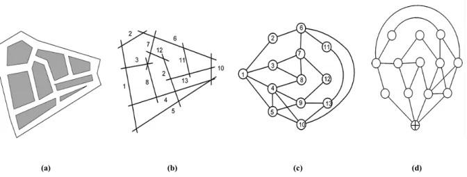
Figure I-1 : Proposed taxonomy of wayfinding tasks, classified by the existence of an external aid, a specific destination and the availability of different levels of knowledge (Wiener, Büchner & Hölscher 2009). ... 10 Figure I-2: Acquisition of spatial knowledge. A person perceives the environment, learns its layout, and stores this knowledge in a mental representation. ... 11 Figure I-3 : Hierarchical mental representation for path planning according to Wiener & Mallot (2003). At the top, the test environment, and its equivalent mental model. In b the starting conditions (position and destinations), and in c the hierarchical paths. ... 18 Figure I-4: Levels of decision (Daamen 2004). ... 19 Figure II-1: Cities with different grid street plans (Hillier 2014). ... 26 Figure II-2: (left) representation of the way people move, mostly along a line; (middle) convex space where users see each other and in which interactions take place; (right) the visibility filed (isovist), which has a different shape depending on where the observer is located (Hillier 2014)... 27 Figure II-3: Axial map (otp.spacesyntax.net 2019). ... 28 Figure II-4: Segment map (otp.spacesyntax.net 2019). ... 28 Figure II-5 : Difference between road segments and line segments (Peponis, Bafna & Zhang 2008). ... 29 Figure II-6 : Space syntax tools (Hillier & Hanson 1984). ... 29 Figure II-7 : Isovist (Batty & Rana 2004)... 30 Figure II-8 : Exemplary illustration of the applied partial isovist (Meilinger, Franz & Bülthoff 2012). ... 31 Figure II-9: Illustrating spatial configuration... 32 Figure II-10: (a) fictive urban system; (b) axial map; (c) connectivity graph; (d) justified graph (Jiang & Claramunt 2002). ... 32 Figure II-11 : Connections in a building. ... 33 Figure II-12 : Generating isovist: (Left) a hypothetical indoor environment; (middle) the shaded area is visible from the person’s observation point within the environment; (right) the resulting isovist and its basic measures (Wiener et al. 2007). ... 35
depth (Turner 2001). ... 36 Figure II-14 : Axial and angular relationship of four street segments (Van Nes & Yamu 2017). ... 37 Figure II-15 : Global Integration of Central London... 37 Figure II-16 : Tate Britain Gallery: traces of visitors (left), visual integration analysis (right) (Hillier 2014). ... 39 Figure II-17 : The movement potentials of each of the 285000 segments of London (Hillier 2014). ... 40 Figure II-18 : Visualisation of bins for a specific point (left) and visualisation of bins and distances from a specific point (right) (Turner 2007b) ... 42 Figure II-19 : Depth on a navigation mesh (left) and Visual Mean Depth on a grid (right). From deeper (segregated) areas shown in red, to shallower (integrated) shown in blue
(Koutsolampros & Varoudis 2017). ... 43 Figure III-1: 3D environment and its corresponding grid of cells. ... 48 Figure III-2 : An example of Road Map generation using a Delaunay Triangulation. ... 49 Figure III-3: An example of Potential Fields corresponding to the original environment: clear (grey) areas correspond to attractive regions (minima) and dark (black) areas correspond to reject (repulsive) regions. ... 50 Figure III-4 : (a) Approximate decomposition by grids (b) Grid abstraction using a three levels quadtree. White boxes are free, grey are obstacles. ... 51 Figure III-5: Example of constrained Delaunay triangulation. ... 52 Figure III-6 : Different representations of an environment, and an example of its navigation mesh: (a) A 3D environment; (b) A walkable environment; (c) A multi-layered environment and (d) A navigation mesh (Oliva & Pelechano 2013)). ... 53 Figure III-7 : NEOGEN subdivision. From left to right we can see the original scene, the result of the layer extraction step after the coarse voxelization, the 2D floor plan of each layer, and finally the near optimal navigation mesh (Oliva & Pelechano 2013). ... 53 Figure III-8 : (a) A simple example environment (wall and ceiling masked for more
visibility); (b) Its prismatic decomposition as generated by TopoPlan (Jorgensen & Lamarche 2014). ... 54 Figure III-9: An Example of a topological abstraction. ... 54 Figure III-10 : Topological abstraction of a virtual environment (a) Corresponds to the
original model, (b) and (c) first and second level of abstraction respectively source (Paris, Donikian & Bonvalet 2006). ... 55 Figure III-11 : The two processed maps (a, b) and the unified map (c) (Mekni & Moulin 2011). ... 57
domain and relations between them. Anchoring is used to establish the basic links between the two hierarchies (solid lines). Additional links can then be inferred by symbolic reasoning
(dotted line), (Galindo et al. 2005). ... 59
Figure III-13 : (a) The environment (b) The topological graph ASR (connections are based on the agent's navigation experience), (Jefferies & Yeap 1998). ... 60
Figure III-14 : Problem of identification of the ASR;(b) it is difficult to detect that the ASR-12 and the ASR-1 account for the same space (c) ASRs-ASR-12 and 1 should logically be grouped together (Jefferies & Yeap 1998). ... 60
Figure III-15 : An example of an IHT-graph (Thomas & Donikian 2003). ... 61
Figure III-16 : A simple cognitive map structure (Thomas & Donikian 2003). ... 62
Figure III-17 : Database/CognitiveMap relation (Thomas & Donikian 2003). ... 62
Figure III-18 : Cells explored by the Dijkstra Algorithm to find a path to the destination node. The pink cell represents the source node; the dark blue cell represents the destination node. The gradient of blue corresponds to the increase of distance, the lightest being the farthest. .. 63
Figure III-19 : The A*'s algorithm search for the shortest path. The pink cell represents the source node; the dark blue cell represents the destination node. The gradient of yellow to blue corresponds to the total cost of path distances (sum of the actual and predicted lengths). ... 63
Figure III-20 : Abstract Graph: Black cells represent obstacles and walls. Entrances are blue cells. Green cell is the start and the red one is the goal. Path between them is with orange colour. ... 64
Figure III-21 : Hierarchical subdivision of a simple map. Red lines in (c) represent inter-edges and yellow lines in (b) and (c) represent intra-edges. Partitions are shown with black (a), blue (b) and red (c) separation lines respectively (Pelechano & Fuentes 2016). ... 65
Figure III-22 : Environment used for spatial reasoning test and path calculated in it out of three different requests (Jorgensen & Lamarche 2011). ... 67
Figure IV-1 : Architecture of the proposed system. ... 76
Figure IV-2: Urban area (Left) Road segments (Right) (Peponis, Bafna & Zhang 2008). ... 77
Figure IV-3 : The informed graph generation. ... 78
Figure IV-4 : Street network subdivided into polygons. ... 79
Figure IV-5 : Recast steps (from left to right) (Mononen 2009)... 80
Figure IV-6 : Example of the topological abstraction. ... 81
Figure IV-7 : Calculating road bucket length. ... 82
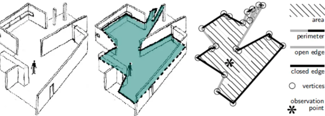
Figure IV-8 : (a) isovist, (b) the partial isovist, and (c) The partial isovist longest ray. ... 84
Figure IV-9 : Mental representation of the environment (Dashed lines represent unknown streets for the agent and bold lines represent known streets)... 86
Figure IV-12 : a. Street experiential hierarchy and agent experience. b. Tow levels of betweenness hierarchy: grey line lower level, black line higher level (Tomko, Winter &
Claramunt 2008) ... 92
Figure IV-13 : Familiarity levels and street prominence. ... 93
Figure V-1 : The movement simulation system architecture. ... 96
Figure V-2 : Modes of access to information. ... 96
Figure V-3: Blue area defines the partial isovist of the green junction towards yellow junction. ... 97
Figure V-4 : Querying the environment through the mental map. ... 98
Figure V-5: Route choice at each intersection. ... 99
Figure V-6 : Two-level hierarchical path planning. ... 100
Figure V-7 : Four classes of leg combinations (Hochmair & Karlsson 2004). ... 108
Figure V-8 : Triangle path length. ... 109
Figure V-9 : Linearity factor evaluated as the angle between previous direction (red) and current direction (yellow). ... 110
Figure V-10 : Directed (Left) and undirected (Right) pathfinding modes in unfamiliar environments. ... 111
Figure VI-1 : Software architecture. ... 117
Figure VI-2 : Creation of the Informed Bucket Graph. ... 117
Figure VI-3 : Software Architecture of IBG-Builder. ... 118
Figure VI-4: Running a simulation with Crowd Simulator. ... 119
Figure VI-5 : Simulation stages. ... 119
Figure VI-6: Stages to configure the simulation environment. ... 120
Figure VI-7 : GIS input data selection... 121
Figure VI-8 : A view in the 3D rendering of the simulation. ... 123
Figure VI-9 : Simulation results in the form of a coloured map using a colour scheme that ranges from the most frequented streets (red) to least frequented (Blue & Adler). ... 123
Figure VI-10 : The chosen test environments maps from Open Street Map (a) Oran1 (b) Oran3 (c) Oran2 (d) Bordj El Bahri (e) Ksar Ghardaia (f) La Medina, Tunisia. ... 127
Figure VI-11: Close-up on the generated environment spatial subdivision (a) Oran1 (b) Oran3 (c) Oran2 (d) Bordj El Bahri (e) Ksar Ghardaia (f) La Medina, Tunisia... 128
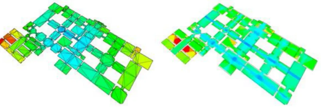
Figure VI-12: Connectivity graph coloured with betweenness centrality using a colour scheme that ranges from the most prominent (dark red) to least prominent (dark blue) (a) Oran1 (b) Oran3 (c) Oran2 (d) Bordj El Bahri (e) Ksar Ghardaia (f) La Medina, Tunisia. ... 129
Figure VI-15 : Screenshots of the second test (a) A close up of the scene showing agents spawned at random locations (b) Certain streets are more frequented than others (c) Red dots represent agent destinations. ... 134 Figure VI-16: Screenshots of the third test (a) A close up of the scene showing agents
spawned at random locations (b) Certain streets are more frequented than others (c) Red dots represent agent destinations. ... 136
List of tables
Table IV-1 : The two main network centrality measures used for correlating with pedestrian
movement (Frith 2017); (Hillier & Iida 2005). ... 90
Table VI-1: Details of the chosen test environments. ... 125
Table VI-2 : Agent population assumptions of the second test. ... 130
Table VI-3: Used strategies in the third test. ... 130
Table VI-4: Results of the first test. ... 131
Table VI-5: Correlation between pedestrian movement simulation and betweenness centrality. ... 134
General Introduction
The patterns of people’s movement in urban systems represent one of the most important areas of research within urban studies. Human movement has been of big concern to a range of disciplines such as traffic engineering, urban design and planning. Therefore, there is a considerable interest in applications of simulating pedestrian movement. Indeed, these applications represent a useful method to help designers to understand the relation between space and human behaviour.
Recently, pedestrian movement simulation has attracted also, the interest of researchers in wireless communication domain. Since wireless portable devices have become indispensable and inseparable objects to humans, they exhibit the same mobility behaviour of them. Consequently, understanding the human mobility has become crucial in network management optimization, allocation of critical resources and development of assisted navigation technologies.
Creating a virtual environment dedicated to simulate pedestrian movement is a challenging task which requires not only creating the virtual environment itself, but also creating the autonomous agents populating it, and modelling the interaction of agents with the virtual environment. At every one of these three tasks, so many challenges arise. Indeed, when creating an environment model we have to deal with several issues such as: how it is represented, how can this representation provide easy and fast accessibility to its data, etc. When creating autonomous agents to simulate the behaviour of navigation we are confronted to a task which is just as difficult and complex. What makes the difficulty of this task is the fact that although navigation is one of the most basic behaviour in real life it is extremely complex and still not fully understood. Therefore in order to create the autonomous agents, we have to solve a set of problems: how to represent them, how to make them move, how to make them reason, plan, and act.
Other important problem as complex and essential as the creation of the environment and the agents themselves: how to make the agents interact with the virtual environment, perceive it, plan their actions according to the virtual environment's characteristics. Indeed, the agents immersed in the virtual environment should be able to perform all the tasks the real pedestrian can: perceive their surroundings, gather information and memorize it, detect and avoid obstacles as well as other agents as they move, and plan a path according to what they see and what they know.
Problem Statement
When simulating large groups of agents, it is not sufficient to only have realistic low level movement for the agents, it is also necessary to endow the agents with a high level behaviour that can closely simulate the decision making process of real people. Most of the work in crowd simulation either deals with simple environments, or assumes every agent has complete knowledge of the environment. Therefore, it is necessary to simulate autonomous agents that can plan a realistic path inside a more or less known environment. Agents should interact with the environment as real people do; therefore the environment model is a very important feature in crowd simulation.
Problems to be addressed in this thesis can be summarized in four points as follows:
1. Creating an environment model that captures the fundamental properties
relevant to the wayfinders. From the ecological psychology point of view, the
people’s movement is considered to be a self-organised phenomena arising through the interaction between among people and their environment. Indeed, people when navigating, they are affected by not only the environment’s geometric or topologic characteristics. Studies in psychology and urbanism have shown that visibility and spatial configuration are also important in the navigation task. Thus, building simulation frameworks using agents which can reason about space not only requires appropriate computation algorithms, but also an efficient description of the spatial environment. Such a description must represent besides the geometrical and topological information the visual and configurational features.
2. Making use of this model in spatial reasoning algorithms in a realistic way to
achieve some human like navigation behaviour. This point is concerned with
the way to access and exploit information, provided by the environment model, in a realistic manner. The first way that our autonomous agent can access information from the environment comes from his ability to perceive it, then to organize his memory and the information he stores there. As for the exploitation, simulations usually resort to path planning. A typical method for doing this planning is to use graph traversal algorithms. Different criteria can be evaluated for the cost of the existing algorithms. Nevertheless, few of these methods combine several criteria at once. Although it seems that the fusion of this information is necessary to get closer to a realistic procedure, since psychological studies have suggested that several of these parameters must be taken into consideration simultaneously. The mixture of criteria therefore seems essential for considering the application of path planning methods to the simulation of virtual humans.
3. Development of a virtual human as realistic as possible. It will therefore have a behavioural chain integrating the capacities that can influence its displacement, such as decision-making regarding navigation. Wayfinding further requires a decision which path (out of multiple options) to take and subsequent locomotion
toward the goal. Several path choice heuristics have been identified that people apply when planning a trip on a map or in a real environment. These movement decisions are influenced by a number of factors, including familiarity with the environment. However, people when they differ in their moving behaviour, this implies that the movement patterns formed by them are fundamentally different. 4. This point arises because of two constraints imposed by the underlying
purpose of this subject, which is movement simulation in an outdoor
environment. First, the proposed algorithms must be sufficiently powerful to simulate a large number of entities, in order to manage crowds of people microscopically. Second, these algorithms must be realistic enough to allow an evaluation and a validation by comparison with real situations, and to produce data which can be studied.
Some commercial software already exists to simulate and analyze crowd movement. Nevertheless, these applications do not completely answer our problem, especially concerning the first and the third points.
The Proposed Approach
In order to design a model of an urban environment, dedicated to simulating pedestrian pathfinding behaviour with a high level of realism, we started from the assumption that it would be interesting to implement theoretical views from two fields: spatial cognition and space syntax. Spatial cognition research is concerned with the acquisition, organization, utilization, and revision of knowledge about spatial environments. It is interested in both the representational format of spatial information as well as in the mental operations that translate such information into navigation behaviour. Space syntax is a term that is used to describe a family of theories and techniques concerning the relationship between space and society. Space syntax research has developed quantitative descriptors of the topological form of settings that are good predictors of where people will be found walking.
The proposed approach is inspired from these two domains, in order to achieve naturally crowd navigation. Thus, we propose a method and associated algorithms to generate virtual environment model populated with autonomous agents. For these agents to be realistic, they handle the necessary behavioural procedures to be able to move and so to plan a path. This model is based on an informed hierarchical abstract graph. This description is enriched with some pre-computations such as potential visual field characteristics, or densities of people, which can be used individually by simulated entities. Furthermore, the way to accesses and to use this informed graph to perform a realistic and efficient path planning, which takes care of individual knowledge of the environment as well as individual preferences. The environment description is also used to endow agents with mental maps which contain the regions supposed to be experienced by them without going through a learning phase. Moreover, the path planning method we propose is influenced by the familiarity of the entity with the environment, which allows the entity to adapt its pathfinding strategy in consequence.
Contributions
The first contribution of this thesis is the description of virtual environments in an automated way, and renders information concerning this environment judged to be relevant in wayfinding, available at low costs: spatial morphology, visual field, etc. The second contribution is a path planning method which is: realistic thanks to the type of managed criteria and the navigation process specific to the level of familiarity; individual to each entity thanks to the environment knowledge and the preference costs; and automatically adaptive thanks to the incremental navigation process; efficient in computation time thanks to the pre-calculations. The third contribution is a method to endow a great number of agents with a mental map. Although, this method doesn’t require a learning time, in order to be efficient in computation time, it permits to simulate the content of the mental maps of real people.
Thesis structure
The thesis is composed of two parts: 1) the state of the art which provides a theoretical background to the thesis by reviewing the body of relevant literature across several fields and 2) the contributions which proceed with a full explanation of the virtual environment model that we propose, the means of its enhancement, and the way we leverage it for movement planning purposes, without forgetting path planning and mental map models.
The first part is itself composed of three chapters: Human movement, Space syntax and
wayfinding, and Modelling pedestrian movement.
Chapter 1 provides an overview of relevant concepts and existing literature in the
field of spatial cognition on mental maps and wayfinding.
Chapter 2 discusses space syntax topics related to the study of space representation
and pathfinding.
Chapter 3 is the last chapter of this first part and it introduces the movement
simulation research field. First, it provides an overview of the approaches used to model pedestrian movement. Then, it presents previous works on virtual environments representation as well as virtual humans cognitive maps. It also details existing path planning algorithms.
The contributions part of this thesis is composed of three chapters: Virtual environment model
and mental map model for pedestrian movement simulation, Simulation model of the pathfinding behaviour in familiar and unfamiliar environments, and Experiments and results.
Chapter 4 this chapter is divided into two principal parts. The first part, presents our
methodology for the generation of informed virtual environments. The second part, presents the structure of the mental map then it details the different steps which compose its creation process.
Chapter 5 presents our incremental path planning algorithm which leverages the
hierarchical topologic graph resulting from the abstraction process. It details how we support spatial agents' navigation in informed virtual environments.
The model presented is then implemented and tested on a test dataset. The computational implementation and the results of the tests are discussed in Chapter 6. Finally, conclusion and perspective section draws conclusions from our work, discusses the main contributions of the thesis, outlines its limits, and discusses avenues for future research and applications.
Chapter I
Human movement
I.1 Introduction
The capacity of moving is, without doubt, one of the basic behaviours indispensible for a human being. People move within cities with different objectives, such as to do shopping, to socialize, to go to some particular place or only to wander. Everyone moves in his own way, with their unique mental and physics distinctive peculiarities and motivations. However, human behaviour is based on a number of shared decision-making parameters and spatial accessibility restrictions imposed by the environment where it occurs.
This chapter reviews previous work in the fields of spatial cognition, related to wayfinding, and the acquisition of spatial knowledge. Without trying to be exhaustive in this domain, we will synthesise a set of studies that have served – or can serve – to the elaboration of computer models. First, section I.2 discusses different definitions of the terms “human movement”, “navigation” and “wayfinding”. Then, section I.3 introduces theories dealing with the mental representation of space. While section I.3 presents theories attempting to explain pedestrian wayfinding behaviour and the cognitive and perceptive processes at work during individual spatial decision-making. Finally, Section I.5 concludes this chapter.
I.2 Human movement, navigation and wayfinding I.2.1 Human movement
When searching the literature for the definition of the term human movement we found that the term is rarely defined. According to Skorupka this is may be caused by the fact that the term wayfinding is often used on movement (Skorupka 2010). Therefore, we need, from the beginning, to differentiate this term from the term wayfinding. In one of the few definitions, movement is considered as any spatial displacement of the body or bodily part initiated by the
person himself [herself] (Buttimer & Seamon 2015). Skorupka (2010) defines human
movement as deliberately walking or making one’s way through some space. Therefore movement can include, among others, travel between known places, navigation to novel destinations, or exploration with no specific destination.
On the other hand, wayfinding is defined by Golledge (1999) as finding one’s way from an origin to a destination. Allen (1999) further defines it as purposeful movement to a specific
destination that is distal and, thus, cannot be perceived directly by the traveller. By comparing
the two definitions, “wayfinding” is also making one’s way, and it falls into the category of movement as an intentional act of making one’s way through the space. However, Skorupka
suggests that the term movement encompasses other types of making one’s way through some space, such as exploration, or movement to known destinations. While Allen (1999) and Wiener, Büchner & Hölscher (2009) in there suggested taxonomies, consider exploration or moving to a familiar destination as wayfinding tasks.
As for human navigation, Montello (2005) describes this term as being a special type of movement of the entire body that is “coordinated and goal-directed”. He advises that navigation is composed of two skills, wayfinding and locomotion. He describes wayfinding as a cognitive process enabling us to plan our movement toward the goal. Locomotion is the skill used to reach the goal by moving the body in a synchronised fashion through, around, over or under obstacles and features of the environment. Next section discusses different definitions of the term “wayfinding”.
I.2.2 Wayfinding
A. Definitions of wayfinding
Emo mentioned in (Emo 2014a) that the word wayfinding owes its roots to the word pathfinder. He argued this connection by the fact that the German word “pfadfinder” closely relates to what we mean by the term wayfinding. This term was used for the first time by Lynch, in the late 70s, to replace the term spatial orientation (Hochmair 2002). Which refers to a person’s ability to determine his or her location in a setting, thus, describes the static relationship of a person to his or her spatial setting. Because the spatial orientation concept cannot encompass the dynamic aspects of people’s movements, the concept wayfinding filled this missing part. Therefore, wayfinding was used to account for people’s movement in space and their sense of being orientated, it described the process of reaching a destination, whether in a familiar or an unfamiliar environment.
There are a number of alternative definitions of wayfinding. Lynch (1960) defines this term as based on: “a consistent use and organisation of definite sensory cues taken from the external environment”. As described by Allen (1999) and Golledge (1999), wayfinding is a directed and motivated movement, with a starting and ending point, whereas such destination is not visible or tangible by the “navigator”. Such behavior involves interactions between the navigator and the environment. Human wayfinding takes place in large-scale spaces (Downs & Stea 1977) (Kuipers 1978). Such spaces cannot be perceived from a single viewpoint therefore people have to navigate through large-scale spaces to experience them. Examples for large-scale spaces are landscapes, cities, and buildings.
Another way to understand “wayfinding” is described as being a series of direction choices, taking place at decision points within the urban grid (Klippel et al. 2004), or still as the ability of finding paths to a particular destination, in a convenient way and being able to recognize the destination once it is reached (Peponis, Zimring & Choi 1990). The definition used in this thesis, based on the (Montello 2001) definition, identifies wayfinding as the decision-making process of navigation; it refers therefore to individual spatial decision-making.
B. Wayfinding elements
Hochmair (2002) analyzed several wayfinding definitions and found some terms that seem to describe a kind of central meaning of wayfinding:
– Decision points
Decision points are those areas where a navigator has the opportunity to select among different paths. Raubal & Egenhofer (1998) distinguish between areas where the navigator has
one obvious option to continue the wayfinding task (enforced decision points) and points
where subjects have more than one choice to continue the wayfinding task (decision points). – The agent has a goal
The goal is a desired position that the agent tries to reach. During the wayfinding process, goal and mental position have a different value. The goal is reached if these two components become equal.
– Order of actions
Actions in wayfinding are ordered. When executed in a sequence, the steps give a certain path of positions. In wayfinding, making a step needs one specific pre-condition (i.e., a specific position in the environment) in order to be performed. Thus, a permutation of a sequence of actions does not give a path (the unique precondition for some of the permutated actions is not given).
I.2.3 Taxonomy of wayfinding tasks
Allen (1999) suggested a taxonomy of wayfinding tasks based on functional goals. It consists of three categories:
1. ‘commute’: travel with the goal of reaching a familiar destination; involves following a familiar route from a known origin to known destination with low levels of uncertainty for the traveller.
2. ‘explore’: exploratory travel with the goal of returning to a familiar point of origin; This involves a familiar start and destination, often the same place, with the aim of finding new places and new paths between these new places and places already known to the traveller. Unlike commute wayfinding which generally uses automatic memory and low levels of effort, explore wayfinding involves conscious cognitive processing. 3. ‘Quest’: travel with the goal of reaching a novel destination. The traveller is proceeding to a specific destination which is unfamiliar to them and which they may not have previously visited. ‘Quest’ wayfinding requires high-level cognitive abilities, greater than those required for explore wayfinding.
Wiener, Büchner & Hölscher (2009) proposed an extended taxonomy of wayfinding that distinguishes tasks by external constraints as well as by the level of spatial knowledge that is
available to the navigator. Their classification takes the navigator’s knowledge, a key factor in wayfinding, into account (Figure I-1).
Figure I-1 : Proposed taxonomy of wayfinding tasks, classified by the existence of an external aid, a specific destination and the availability of different levels of knowledge (Wiener, Büchner & Hölscher 2009).
I.3 Mental representation of space
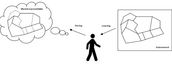
It is to the mental representation allowing the first type of reasoning –navigation that we will attach here. Human being needs to represent the environment even before being able to move in it. Indeed, this mental representation will serve him to reason about this environment, to evaluate a path to achieve a precise location or to organize the tasks he has to perform. People learn the layout of their environment through continuous interaction. They perceive the environment through senses, learn the layout of the environment and store the knowledge acquired in mental representations (Figure I-2).
Mental representation that corresponds to people’s perceptions of the real world is called “cognitive map”. This term appeared for the first time in a paper by Tolman (1948). Other terms, such as cognitive collage (Tversky 1993) or cognitive atlas (Hirtle 1998) have also been proposed.
Figure I-2: Acquisition of spatial knowledge. A person perceives the environment, learns its layout, and stores this knowledge in a mental representation.
I.3.1 Conceptualisation of Space
A number of studies have examined the role of cognitive maps on wayfinding behaviour, notably on how information is ordered and depicted. In cognitive neuroscience, recent researches found that there are three types of cells representing different types of spaces: place cells describing where, head direction cells on the direction, and grid cells reflecting the distance (Dalton, Hoelscher & Spiers 2015). Although, following the representational theory of mind, the basic elements of mental representations are called concepts (Margolis & Laurence 2010). Concepts are the result of a cognitive process of categorization of the knowledge acquired while perceiving the world (Rosch 1978). The goal of the cognitive process is to create a simplified, abstract model of the knowledge acquired, in order to reduce its complexity and thus the mental effort required to store it. Furthermore, conceptualizations allow generalizations and abstract reasoning about the domain of knowledge processed. An important contribution to the conceptualization of space is the work of the urbanist Kevin Lynch, studying the phenomenon of imageability of urban environments. Lynch (1960) interviewed residents of three cities and found out that people build their mental model of a city based on five spatial elements. These elements present the basic concepts in the static spatial mental representations, i.e. the image of the city people retain after experiencing it. Briefly, Lynch defines the elements of the city form as follows:
1. Landmarks, distinct points in a city that serve as reference to the user. 2. Paths, channels of movement.
3. Nodes, strategic spots in the city where the observer can enter.
4. Edges are linear but do not facilitate movement. They form physical barriers.
5. Districts are areas in a city that have some common characteristics such as a particular architectural style.
I.3.2 Scale of environment
Scale is an essential component in the process of navigation because different size spaces result in qualitatively distinct knowledge acquisition (Bell 2002). The widely accepted
classification includes small-, medium-, and large-scale based on the absolute sizes of space. Gärling & Golledge (1989) suggested that small-scale space is comprehended from a single vantage point, from which the whole environment could be perceived. A single room or a small triangular route has served as an example of small scale space in empirical studies (Foo et al. 2005). Knowledge can be acquired directly in both small-scale and medium-scale space, though the latter is slightly larger than the former. For large-scale spaces such as a neighbourhoods, towns, or cities which are much more complex and of a larger size, spatial relationship cannot be perceived directly. In this space locomotion is required for a traveller to acquire and update information to make navigational plans (Garling, Book & Lindberg 1984). Montello (1993) proposed another systematic classification based on the relative size of the space to the human body, which consists of figural, vista, environmental, and geographical space. The figural and vista spaces share similar characteristics with the previous small-scale space as they could be perceived from a single vantage point. In a figural space the human body is larger than the space in question. The vista space is relatively larger than the human body but still can be comprehended from a single point. In Montello’s description, an
environmental space is larger than the body and cannot be comprehended directly without
locomotion. Finally, geographical space is much larger than human body and must be learned through symbolic representations like maps.
I.3.3 Development of cognitive maps
The development of cognitive maps is incremental, i.e. at the beginning, cognitive maps are fragmentary, and then, with further spatial experiences, they are completed and substantiated (Hochmair 2002). However, several authors (Siegel & White 1975; Thorndyke 1981) assume that spatial knowledge acquisition follows a main sequence of landmark, route and survey knowledge in ascending order.
1. Landmark knowledge comprises distinct, typically familiar points in the environment. 2. Route knowledge is characterized by the knowledge of paths between landmarks
(topological information).
3. Survey knowledge allows people to locate landmarks and routes within a general frame of reference (i.e., incorporating metric measurements).
Landmarks are the first elements to be included into spatial representations. At that early stage, we speak of landmark knowledge. People can describe single features of the route, but most of them are not able to retrieve the route alone.
Further on, these points are connected by the most frequently travelled routes. Route knowledge consists of the familiar routes connecting junctions and/or landmarks. Route
knowledge is acquired gradually and therefore features a sequential structure. The sequence
of landmarks and turnings is used to proceed on the entire route. People are able to retrieve the route and the goal and possibly to go back and find the starting point.
At both levels, spatial knowledge is egocentric, i.e. depending on the actual position and viewing direction of the navigator, whereas at the third and last distinguished level, survey
knowledge, spatial knowledge is allocentric, i.e. independent from the individual. In order to
gain an overall picture, landmarks and several routes are integrated in a more and more complex network. Survey knowledge exists if shortcuts and bypassings are found, good direction estimations and beeline distance estimations are made, and if some variations in the specific routes do not prevent subjects from finding their way (Tolman 1948).
The speed with which people learn the environment and transit between these stages of spatial mental representations depends on each individual, and his spatial abilities (Allen 1999) and the frequency of interaction with the environment. Continuous interaction with the environment allows proceeding from landmark to route to survey knowledge. It has been recently hinted, however, that these types of knowledge may be acquired simultaneously (Ishikawa & Montello 2006), depending on the individual’s spatial abilities. For instance, some individuals may acquire basic metric characteristics of space after relatively little interaction. Thus, continuing interactions allows the accuracy and completeness of the acquired spatial knowledge to improve, although individual differences in spatial abilities effectively impose a limit to such improvements. Thus, individuals with innate good spatial abilities or good spatial training (e.g. geographers (Golledge 1995), taxi drivers) may quickly form accurate and relatively complete spatial mental models of the environment. This progression happens, however, not in months or years as previously suggested, but within a few trips through the environment in question (Ishikawa & Montello 2006).
The mental representation acquired through direct experience of the environment is further supported by secondary, indirect spatial learning. Inhabitants of a city enhance their spatial knowledge from sources such as maps, news articles, advertisements and Web resources. These spatial narratives (Levine & Klin 2001) and geo-referenced descriptions (Winter & Tomko 2006) add to the spatial mental representations of people residing in a specific city during longer periods of time.
When orientating and navigating, people use their present spatial knowledge to develop an action plan. The navigation strategies are based on the spatial information available. Thus, a subject disposing of survey knowledge can choose from a larger number of strategies than a subject disposing only of landmark or route knowledge.
Although Golledge (1999) argues that cognitive maps are necessary for human navigation, people have the ability to find their ways in unfamiliar environments—such as a newly experienced airport or hospital—without referring to a previously acquired cognitive map. One could argue though that people build some sort of mental collage at each bifurcation, which is essentially an integration of different views at a decision point. Such representation helps them in making a decision of how to proceed further.
I.3.4 Graph-based models of space
In spatial cognition and artificial intelligence, graphs have been used for decades as model for mental representations of environments. For example, in 1979, Byrne suggested that the memory for urban environments is realized in a network of places. Ever since, a multitude of such graph-like models of spatial memory have been developed (Franz et al. 2005).
The particular appeal of graph structures as models for spatial memory arises from their superior flexibility as compared to map-like representations of space. For example, while basically being topological structures, by labelling or weighting single edges of graphs, distance and direction information can be included that allow for metric navigation abilities such as short-cutting behaviour (Hübner & Mallot 2002). Additionally, various non spatial information can be attached to the nodes, for example, places can be labelled with emotional or episodic information (Franz et al. 2005) . Also, graph structures permit the representation of inconsistencies and incomplete knowledge, factors that appear necessary to explain several empirical findings in human spatial cognition. Taken together, due to their minimalism and efficiency, graph-like mental representations of space are ecologically plausible, sufficient for the explanation of a wide range of behaviour, and, last but not least, they fit well to the neural structure of human brains (Franz et al. 2005).
I.3.5 Hierarchical Structure of Spatial Mental Representations
Human spatial memory has a certain property, namely its hierarchical organization that lately has been shown to influence route planning and navigation behaviour (Wiener & Mallot 2003). Hierarchical theories of spatial representations state that spatial memory contains nested levels of detail. Such a memory structure can be expressed in graph like representations of space in which locations are grouped together and form super ordinate nodes.
I.3.6 Experiential Hierarchies
Experiential hierarchies form in mental representations as a product of the interaction of wayfinders with the environment. The intensity of experience of a spatial feature is related to its functional, structural or semantic (individual) prominence in a specific environment. This experience of prominence establishes a partial order between the mental representations of the individual spatial features, and an experiential hierarchy emerges (Tomko, Winter & Claramunt 2008).
I.4 Spatial reasoning and decision making
Spatial reasoning involves a variety of decision-making methods and choice behavior. Decision theory covers a large range of models with different foci on describing how decisions could or should be made and on specifying decisions that are made (Golledge 1997). Mathematically, a decision rule is a function that assigns a value to each alternative, showing what will happen when a particular strategy is adopted. Decision-making criteria are a set of procedural rules that oversee the evaluation of the outcome when decision rules are applied to a task situation. A strategy contains decision rules that seek a result from all possible ways of making a relevant decision. Golledge (1997) argues that in many cases
human decision-making is not strictly optimizing in an economical and mathematical sense and therefore emphasize behavioural decision theory.
I.4.1 Spatial cognition
The word spatial is defined as “concerning or existing in space” (Oxford advanced learner's
dictionary of current English 1992) or “relating to space”(Collins dictionary of the English language 1986). Spatial cognition refers to both the perceptual and conceptual processes that
are involved in understanding the physical environment. This theory proposes that the perceiver has certain cognitive structures called schemata that enable the perception and therefore pick-up of information from the environment.
Spatial abilities are cognitive functions that enable people to deal effectively with spatial relations, visual spatial tasks and orientation of objects in space. One aspect of these cognitive skills is spatial orientation, which is the ability to orient oneself in space relative to objects and events; and the awareness of self-location (Arthur & Reber 1985).
Human spatial cognition is a part of the interdisciplinary research area of cognitive science. Researchers from many academic disciplines, such as psychology, linguistics, and computer science investigate about the mind, reason, experience, and people’s conceptualizations of the world in which they live. The discipline spans a vast number of topics, such as spatial perception, spatial memory, cognitive modelling, individual differences, neuroscience and navigation.
I.4.2 Individual differences in the human wayfinding decision making process
Individual differences are the ways in which people differ in their behaviour. Psychological research has shown that individual differences exist for spatial task performance.
– Decision style
Each pedestrian makes decisions based on a decision style, which may be different for the various types of decisions (Bovy & Stern 1990). Decision styles are based on herding behaviour, utility maximisation, and habitual behaviour (Avineri & Prashker 2006).
– Age
Previous research has shown that older adults do not perform as well as younger adults on a variety of spatial tasks, including those requiring information about specific environmental layout (Kirasic 2000) and forming cognitive maps or surrounding environment (Iaria et al. 2009).
– Gender
According to Seneviratne & Morrall (1985) and (Verlander & Heydecker 1997) the choice of route appears to be not much different between the two sexes, while Chebat, Gélinas-Chebat & Therrien (2008) found that males are more efficient than females; for example, some researchers have found that men are more efficient at finding destinations(Malinowski & Gillespie 2001). Males have better knowledge of geographical maps and draw better maps (Harrell, Bowlby & Hall-Hoffarth 2000), which is usually attributed to the fact that men are more socialised with maps (Lawton & Kallai 2002).
Another implication of gender differences is that women and men may differ in strategies for finding a destination where females are more likely to adopt the egocentric strategy and the males are more likely to adopt the allocentric strategy (Chen, Chang & Chang 2009). Another possible implication of gender differences is that women and men may differ in the way they feel about performing tasks that appear to require a sense of direction. Women show a higher level of anxiety than men such as trying a new shortcut without the aid of a map or figuring out which way to turn when emerging from a parking garage (Lawton & Kallai 2002). Women show a higher level of anxiety than men such as trying a new shortcut without the aid of a map or figuring out which way to turn when emerging from a parking garage (Lawton 1994).
I.4.3 Mechanisms, strategies and heuristics of route planning
Golledge (1995), with a series of pilot experiments, has demonstrated that the path selection problem is the result of minimizing procedures such as selecting the shortest path, the quickest path or the least costly path. This statement has been assumed by researchers; indeed, when walking from a trip origin to a destination, a pedestrian typically tries to minimize a variety of costs, including distance, travel time, cognitive cost. However, the critical issue identified by these researchers is which mechanisms, strategies and heuristics are applied during route planning that allows deriving the shortest path, the quickest path or the least costly path?
There exists a large body of research that analyses the different criteria a pedestrian may consider when choosing a route from among a variety of path alternatives. This section discusses the cognitive and perceptive processes at work during individual spatial decision-making.
– Initial segment strategy
The initial segment strategy (Neisser 1976) (Bailenson, Shum & Uttal 2000) suggest that people tend to focus disproportionately on the initial portions of the route and that they prefer routes with longer straight initial segments, regardless of what the later portions of the routes look like. This strategy is motivated by the idea that people, by turning as late as possible, try to minimize the cognitive effort required for navigation. They did not worry about when and where to turn until they had to turn.
Results of experiments conducted by researchers among them Dalton (2003) have revealed that subjects choose the straightest possible routes and defer turns in situations with several path choice options that were equal with respect to distance, time, and number of turns when crossing a street. These findings confirm the initial segment strategy. It also support a hypothesis by Hillier (1997) that people tend to follow the longest line of sight that approximates their heading. This strategy offers a possible explanation for the fact that people’s route choices are often asymmetric; i.e. people choose different routes from A to B than from B to A (Dalton 2003).
– Least-angle strategy
With the least-angle strategy (LA) (Hochmair & Frank 2000); (Dalton 2003), the navigator aims at maintaining track of the target direction throughout the trip. This heuristic states that people choose the path that is closest (in terms of angularity) to a direct line between their current position and the goal.
– Least-decision-load-strategy
The least-decision-load-strategy states that subjects, when having the choice between alternative paths, choose the path that minimizes the number of possible movement decisions (Wiener, Ehbauer & Mallot 2007). Such a strategy could be employed, because the risk of getting lost is smaller on less complex routes.
– Progressive planning based on landmarks
Landmarks are often stored in memory and recalled later because of the dominance of their visible form, the peculiarity of their form or structure. A marker also helps insofar as it can indicate where the action or movement should change (the point where you have to turn, for example), the location near other landmarks, where the path that we have just taken is good (confirmation function by reference). It is absolutely essential to have a good knowledge of the geometry of the roads to be able to go from one landmark to another without difficulties. The frequency with which landmarks are mentioned as an aid to navigation gives rise to inter-individual differences. For example, it has been shown that women's strategies are largely based on visual cues and more often than men's (Tom & Denis 2003).
– Regionalized environments
Stevens & Coupe (1978) demonstrated that people construe spatial representations that are geared to existing structures in the environment. Wiener, Schnee & Mallot (2004) conducted a study in a Virtual Reality (VR) setting in which they found that people performed better in a search task when target landmarks were grouped by colour than when they were not. This study indicate that people do mentally divide space into regions and that regionalized environments and respective representations can facilitate wayfinding, resulting in better performance. The regions are perceived and encoded in spatial memory very early during the process of learning an environment. During navigation such regional information could be used to overcome missing or imprecise spatial information on the detailed level.
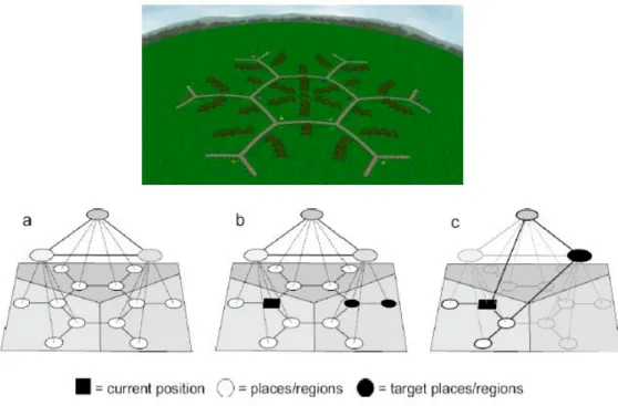
– Fine-to-coarse
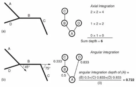
A second line of research describes heuristics derived from hierarchical representations of space. Wiener & Mallot (2003) proposed the fine-to-coarse planning heuristic, a cognitive model that describes this simultaneous use of spatial information at different levels of detail during route planning (Figure I-3). The core of this fine-to-coarse heuristic is the ‘focal representation’ that is generated from the hierarchical reference memory of space by using
fine space information (place-connectivity) exclusively for the current location and the close surrounding and coarse space information (regions-connectivity) exclusively for distant locations. In this focal representation, the shortest path to the next target (target-place or target-region) is planned. Planning a route in such a focal representation results in a detailed plan for the close surrounding allowing for immediate movement decisions, while only coarse spatial information is available for distant locations. The route plan therefore has to be refined during navigation.
– Cluster-strategy
The cluster-strategy states that human route planning takes into account the distribution of target locations within an environment, resulting in a preference for paths that allow visiting as many target places as fast as possible (Gallistel & Cramer 1996).
Figure I-3 : Hierarchical mental representation for path planning according to Wiener & Mallot (2003). At the top, the test environment, and its equivalent mental model. In b the starting conditions (position and destinations), and in c
the hierarchical paths.
I.4.4 Decision levels
In the 80s, wayfinding was modelled as spatial problem solving (e.g. (Downs & Stea 1977)), which comprises four distinct stages. These are:
– spatial orientation which is the identification of the self location and target location within the environment;
– the selection of the initial route from the starting location to the target;
– continuous monitoring of the route taken, modified by estimates of self location and target location and reassessment or confirmation of route choice;