O
pen
A
rchive
T
OULOUSE
A
rchive
O
uverte (
OATAO
)
OATAO is an open access repository that collects the work of Toulouse researchers and
makes it freely available over the web where possible.
This is an author-deposited version published in :
http://oatao.univ-toulouse.fr/
Eprints ID : 11699
To link to this article
: doi:10.1016/j.jsames.2012.06.005
URL : http://dx.doi.org/10.1016/j.jsames.2012.06.005
To cite this version
: Anthony, Edward J. and Gardel, Antoine and
Proisy, Christophe and Fromard, François and Gensac, Erwan and
Peron, Christina and Walcker, Romain and Lesourd, Sandric The role
of fluvial sediment supply and river-mouth hydrology in the dynamics
of the muddy, Amazon-dominated Amapá–Guianas coast, South
America: A three-point research agenda. (2013) Journal of South
American Earth Sciences, vol. 44 . pp. 18-24. ISSN 0895-9811
Any correspondance concerning this service should be sent to the repository
administrator: [email protected]
The role of fluvial sediment supply and river-mouth hydrology in the dynamics of
the muddy, Amazon-dominated Amapá
eGuianas coast, South America:
A three-point research agenda
Edward J. Anthony
a,*, Antoine Gardel
b, Christophe Proisy
c, François Fromard
d, Erwan Gensac
b,
Christina Peron
b, Romain Walcker
d, Sandric Lesourd
baAix Marseille Univ., Institut Universitaire de France, CEREGE, UMR CNRS 7330, Europôle Méditerranéen de l’Arbois, B.P. 80, 13545 Aix en Provence Cedex, France bUniversité du Littoral Côte d’Opale, Laboratoire d’Océanologie et de Géosciences, CNRS UMR 8187 LOG, 32, Avenue Foch, 62930 Wimereux, France
cIRD/UMR AMAP, botAnique et bioinforMatique de l’Architecture des Plantes, TA A51/PS2, Boulevard de la Lironde, 34398 Montpellier Cedex 5, France dCNRS, UPS, INP, EcoLab e Laboratoire d’écologie fonctionnelle UMR 5245, 29 rue Jeanne Marvig, 31055 Toulouse, France
Keywords: Amazon Guiana Shield Mud banks Rivers
River-mouth hydraulic groyne Muddy coast
Sandy cheniers South America
a b s t r a c t
The morphology and sediment dynamics of the 1500 km-long coast of South America between the mouths of the Amazon and the Orinoco Rivers are largely dependent on the massive suspended-sediment discharge of the Amazon, part of which is transported alongshore as mud banks. These mud banks have an overwhelming impact on the geology, the geomorphology, the ecology and the economy of this coast. Although numerous field investigations and remote sensing studies have considerably enhanced our understanding of the dynamics of this coast over the last three decades, much still remains to be understood of the unique functional mechanisms and processes driving its evolution. Among the themes that we deem as requiring further attention three come out as fundamental.
The first concerns the mechanisms of formation of individual mud banks from mud streaming on the shelf off the mouth of the Amazon. An unknown quantity of the fluid mud generated by offshore estuarine front activity is transported shoreward and progressively forms mud banks on the Amapá coast, Brazil. The volume of each mud bank can contain from the equivalent of the annual mud supply of the Amazon to several times this annual sediment discharge. The mechanisms by which individual banks are generated from the Amazon turbidity maximum are still to be elucidated. Areas of research include regional mesoscale oceanographic conditions and mud supply from the Amazon.
The second theme is that of variations in rates of migration of mud banks, which influence patterns of coastal accretion. Research emphasis needs to be placed on the analysis of both regional meteorological-hydrodynamic forcing and distant Atlantic forcing, as well as on the hydrology of the large rivers draining the Guyana Shield. The rivers appear to generate significant offshore deflection of mud banks in transit alongshore, through a hydraulic-groyne effect. This may favour both muddy accretion on the updrift coast and downdrift mud liquefaction with probably lessened muddy deposition.
The third theme concerns sand supply by the Guiana Shield rivers. The rare sand deposits are important in providing sites for human settlements and routes and for nesting by marine turtles. The limited presence of sand bodies on this coast may reflect ‘mud blanketing’, a hypothesis that requires verification through high-resolution seismic analyses of shelf deposits and coring operations. The large Guiana Shield rivers, especially in Surinam and Guyana, have supplied sand for the construction of significant bands of cheniers, probably enhanced by the afore-mentioned downdrift hydraulic-groyne effect on hindered mud deposition. In all the three themes of this future research agenda, two central elements are the sediment input of the rivers of the Amazon basin, starting with the massive mud supply from the Amazon catchment itself, followed by sand inputs by the Guiana Shield rivers and their river-mouth effects on mud banks.
* Corresponding author.
E-mail address:[email protected](E.J. Anthony).
1. Introduction
The Atlantic coast of South America between Amapá, in Brazil, and Venezuela (Fig. 1a), constitutes the terminus of rivers draining the Andes, the Amazon basin and the Guiana Shield. By far the most important of these rivers is the Amazon itself. The objectives of the FrencheBrazilian Observatory of Research on the Environment of the Amazon Basin (ORE HYBAM (http://www.ore-hybam.org)), as stated byCochonneau et al. (2006), are to foster a better under-standing of the hydrology, geomorphology and sediment budgets of these rivers. These objectives have met with success over the last few years, especially as regards the geomorphology, sediment storage patterns, and sediment budgets, notably of the Amazon itself (Filizola and Guyot, 2009; Martinez et al., 2009; Wittmann et al., 2011). However, the links between, on the one hand, the hydrology, sediment budgets and overall source-to-sink sediment dynamics of these rivers and, on the other, the 1500 km-long coast from Amapá to Venezuela are still poorly understood, notwith-standing the fact that this coast is characterized almost exclusively by terrigenous, fluvially transported sediment inputs.
The large supply of mud by the Amazon River has dominated the geological development of this coast, via a system of mud banks that migrate from the mouth of the Amazon to that of the Orinoco (Fig. 1b). This mudebank system appears to be unique in terms of both the magnitude of mud migration alongshore and the mud dynamics, due to the extremely large and pervasive supply of mud by the world’s largest river. This supply involves mud concentration processes within an atypical shelf-based estuarine turbidity maximum, and conservative onshore-alongshore mud transport along an energetic inner shoreface belt along the AmapáeGuianas coast. The significant mud accumulation has led to the growth of a shelf clinoform structure at the mouth of the Amazon and to more or less important coastal progradation throughout the coast of the Guianas and into Venezuela. The spatial (and temporal) imprint of the waxing and waning of mudebank activity is characterized by ‘bank’ and ‘inter-bank’ phases, and locally by ‘transitional’ phases. Over time, the rhythmic nature of these alternating phases has an overwhelming impact on the coast, inducing rapid shoreline accretion and/or erosion, as well as important ecological changes involving the development and destruction of mangrove forests. This high mud supply also has strong impacts on the coastal economy of all the countries between the mouths of the Amazon and the Orinoco: Brazil, French Guiana, Surinam, Guyana and Venezuela.
There has been significant progress in understanding the development and morphosedimentary dynamics of this coast. Studies have notably focussed on processes of mudebank migra-tion, mudebank interaction with the shore, and the influence of mud banks on mangrove dynamics. Progress accomplished over the last three decades has been summarized recently byAnthony et al. (2010), to which the reader interested in a comprehensive review of the Amazon mudebank system is referred. The findings examined in this research review were based on a wide range of methodological procedures and techniques, including new field and remote sensing approaches. Field approaches involve consid-erable logistical difficulties, including the challenge of accessing experimental sites, and have included measurements of cross-shelf wave dissipation on mud beds, seismic profiling, high-resolution in situmapping of mudebank topography, monitoring of mudebank sedimentation rates through ultrasonic altimetry, in situ instru-mented monitoring, time-lapse photography to monitor changes in the surface properties of mud banks, and especially remote sensing, which, given the problems of field access, has been widely used for the analysis of coastal forms, physical processes, and mangrove ecology at various scales. In particular, topographic data-extraction
from temporal series of satellite images and Lidar-derived digital terrain modelling have been used with success to highlight patterns of medium- (months) to long-term (years) mudebank dynamics and coastal evolution.
The review depicted a highly complex system that has still left many questions unanswered regarding the dynamics of this coast. The objectives of the present paper are to highlight three themes that provide a full research agenda in the coming years. These themes will require more insight into the role of fluvial sediment supply from the Amazon drainage system, both as regards the Amazon River itself, and the smaller rivers that debouch on this Amazon-dominated coast, and should help in bridging the gap between advances on catchment hydrology and sediment budgets and that have been largely fostered by the ORE HYBAM and our understanding of the dynamics of the coastal terminus of the Amazon and Guiana Shield rivers. These themes are: (1) Amazon mud supply, and processes and timescales of mudebank forma-tion; (2) mechanisms and timescales of mudebank migraforma-tion; and (3) sand supply by the Guiana Shield rivers debouching on this coast.
2. Amazon mud supply, and processes and timescales of mudebank formation
The influence of the Amazon on the sediment dynamics of the AmapáeGuianas coast essentially resides in the unique belt of mud banks that circulate alongshore. These mud banks constitute, however, only an estimated 15e20% of the muddy discharge from the Amazon (Augustinus, 1978; Wells and Coleman, 1978), a percentage that needs to be more thoroughly verified. This discharge progressively forms highly turbid suspensions (>1 g l1)
in the vicinity of the mouth of the river that are the precursors of the mud banks. The formation of distinct mud banks that migrate alongshore as discrete sediment bodies suggests periodic (order of several years) and localized mud concentration mechanisms that are a major element of the future research agenda. Two areas of research are needed in order to gain a better insight on this theme. The first concerns the mud discharge from the Amazon, and the second the oceanographic context of mudebank formation.
The Amazon is the world’s largest river system with a drainage basin of 6.1 106km2(Organization of American States, 2005). The
mean annual water discharge at Óbidos (Fig. 1a), 900 km upstream of the mouth, has been estimated at 173,000 m3s1byMartinez
et al. (2009) from continuous gauging between 1995 and 2007. Estimations of sediment discharge published over the last four decades have varied widely, ranging from 5 to 13 108m3yr1, according toMartinez et al. (2009). Following careful monitoring of a suspended-sediment discharge network at Óbidos run by the ORE HYBAM between 1995 and 2007,Martinez et al. (2009)computed a mean annual mud discharge of about 754 106tonnes yr1, with
a coefficient of variation of 8.6%. They also highlighted a good agreement (to within 1.8e3%) between their suspended-sediment concentrations and data derived from a MODIS space-borne sensor. A budget analysis by Wittmann et al. (2011), based on cosmogenic nuclides, suggests a similar value.Filizola and Guyot (2009) assessed the Amazon sediment yield from the Brazilian national data set comprising over 60 sites since the 1970s and have suggested a value of over 1000 106tonnes yr1.Martinez et al. (2009)have shown that compared to the relatively regular liquid discharge of the Amazon, there was more significant inter-annual variability in sediment discharge but the large Amazon floodplain has also been shown to have a significant buffering role on sedi-ment budget variability.
The way variations in mud supply by the Amazon may play a role in mudebank formation is not clear. An indication may,
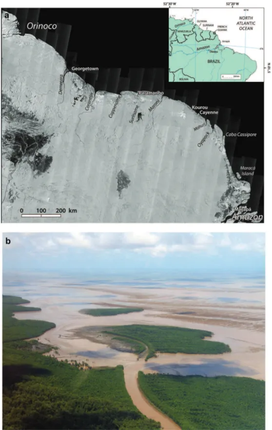
Fig. 1.(a) A 2006 JERS-1 satellite image of the muddy AmazoneOrinoco coast, the world’s longest muddy coast. Mud banks start forming in the Cabo Cassipore area rather than along the coast nearer to the mouth of the Amazon. This is due to the significant offshore location of the non-confined estuarine turbidity maximum of the Amazon and westward along-shelf deflection of this maximum towards the coast near Cabo Cassipore, directly south of which the Amapá coast appears to be mud-starved (see text). (b) The oblique aerial photograph shows a typical mud bank in French Guiana partly colonized by mangroves and cut by drainage channels. The bare part of the mud bank in the background shows a series of linear mud bars. This mud bank is one of several (up to 15 or more) banks migrating at any time from the mouth of the Amazon River in Brazil to that of the Orinoco River in Venezuela.
however, be derived from the sheer volume of an average bank and the large number of mud banks. In any year, the number of mud banks throughout the 1500 km-long AmapáeGuianas coast may be 15 or more. The banks are spaced at intervals of 15e25 km, are up to 5 m thick, 10e60 km long and 20e30 km wide. The volume of each mud bank can contain from the equivalent of the annual mud supply of the Amazon to several times this annual supply. This, combined with the large number of mud banks at any time, suggests that periodic bank formation may not be principally related to the hydrology of the Amazon, such as through seasonal variations in mud discharge.
The other area requiring research concerns the context and mechanisms involved in the formation of individual mud banks. In other words, how does the quasi-continuous Amazon mud load, albeit with seasonal variations, goes from streaming, away from the mouth of the Amazon, to discrete mud banks? The mud concen-tration processes that are a precursor to the formation of distinct mud banks start on the continental shelf seaward of the mouth of the Amazon in water depths of about 20e60 m, where much of the suspended-sediment discharged by the river is initially stored, via rapid and sustained fluid-mud concentration and trapping associ-ated with fresh wateresalt water interaction and ‘unconfined’ estuarine front activity (Geyer and Kineke, 1995; Kineke et al., 1996). The link, however, between these estuarine sediment concentration processes that presumably maintain a massive inner shelf turbidity maximum and the subsequent mudebank belt still remains elusive. Mud is remobilized and transported shoreward and then alongshore by a complex combination of wave forcing, tidal currents, and wind-induced coastal currents, but the contri-butions of these transport mechanisms and their temporal and spatial frames are still to be elucidated.Nikiema et al. (2007)have shown, from coupling of a 3D hydrodynamic model with the bathymetry and the coastline, that a strong coastal current asso-ciated with the mesoscale North Brazil Current generates perma-nent northwestward extension of the sediment-charged Amazon plume, confirming earlier observations that attributed this net northwestward plume, and ambient shelf water motion, to a large-scale pressure gradient associated with this current system (Geyer et al., 1996).Molleri et al. (2010)have shown from satellite images of seawater salinity that the northwestward flow of the Amazon plume occurs in a narrow coastal band from January to April. This period also corresponds to the annual peak in trade winds and wave activity affecting the AmapáeGuianas coast. In addition to energetic forcing by waves, by near-resonant semi-diurnal tides and by large buoyancy flux from the Amazon River discharge, the shelf is also subject to stress from the northeasterly trade winds, resulting in strong along-shelf flow associated with the North Brazil Current (Geyer et al., 1996).Martinez et al. (2009)showed a strong concentration of muddy discharge (51% on average over the period 1995e2007) between January and April, with little variability from year to year.
Sustained relaxations in the forcing conditions that lead to alongshore streaming of Amazon mud, such as in the North Brazil Current due to mesoscale changes in wind intensity, as hypoth-esised byEisma et al. (1991), and subsequently byAllison et al. (2000), could be responsible for relaxations in mud streaming that may be a mechanism leading to disruption of the mud belt, thus generating discrete mud banks. One area of future research here could concern the climatic, hydrological and meteorological connections implicated in both the Amazon basin discharge and in the hydrodynamic context at the mouth of the Amazon and its environs, where the mud banks are generated from the mud stream.
Allison et al. (2000)have shown that the mud banks originate in the vicinity of Cabo Cassipore, a muddy cape 350 km northwest of
Maracá Island at the mouth of the Amazon (Fig. 1a). These authors highlighted a zone of relative water-column mud ‘deficit’ close to the northwestern approaches of the mouth of the Amazon between Cabo Cassipore and Maracá Island, and showed that the proto-mud banks started forming in the vicinity of this muddy cape. Direct shoreward deflection of the Amazon mud-charged plume, with little influence by the Coriolis force in this equatorial setting, may be responsible for the mud-deficient coast between Maraca Island and Cabo Cassipore.Allison et al. (1995)have suggested that up to 150 106tonnes of mud (ca. 20% of the annual mud discharge monitored byMartinez et al. (2009)) may be stored in a year in the Cabo Cassipore area.
3. Mechanisms and timescales of mudebank migration Downdrift of the mouth of the Amazon, the dynamics of mud banks depend on their interactions with waves and currents, with the shoreline, and on in situ changes, including those associated with mangrove colonization and destruction. These interactions involve wave energy dampening, cross-shore and alongshore mud advection, mudebank consolidation, fluidization and liquefaction, and mangrove colonization and removal. These processes lead to constant variations in mud concentrations and consolidation (Gratiot et al., 2007). In bank phases, these stages range from very high suspended-sediment concentrations (1e10 g l1), through
fluid mud, to settled mud, which, in turn, ranges from under-consolidated (!650 g l1) to consolidated sediment beds
("750 g l1). Inter-bank zones are generally associated with less
turbid waters (SSC of <1e5 g l1).
Under strong wave action, fluid mud pushed shoreward during the neap-to-spring cycle results in overall accretion and increase in bank elevation. The mobilized mud layers generally form mud bars. The most important element of waveemud interaction, however, is that of the migration of mud banks alongshore under the dominant influence of waves (Wells and Coleman, 1978; Gratiot et al., 2007), a phenomenon of overwhelming geological, geomorphic, ecological and economic importance on the AmapáeGuianas coast.Gratiot et al. (2007) showed that notable phases of increased wave energy were accompanied by higher annual rates of longshore mudebank migration, but that the correlation was rather poor between the wave forcing parameter combining wave height (H) and period (T), H03/T2, and migration rates because of the
contri-bution of other mechanisms to bank migration, including wave incidence angle and wind stress. These other mechanisms consti-tute another important research area for the future. Changes in wave conditions provide, however, only a partial answer. The mean mudebank migration rate from 1995 to 2000 was twice that from 1979 to 1984, for instance, even though the wave forcing parameter, H03/T2, identified byGratiot et al. (2007)from a 44-yr record of the
ERA-40 wave data set was only 33% higher. It may be inferred from these observations that differences in migration rates may also account in part for variations in the spacing between the banks, and possibly bank morphology as well, notably where mud banks are ‘stretched’ alongshore.
On the basis of the foregoing, emphasis in research on the causes of temporal variations in migration rates should be placed on the analysis of both regional meteorological-hydrodynamic forcing and distant Atlantic forcing. Regional sources of variability that need to be investigated include variations in the North Brazil Current (Nikiema et al., 2007), density currents due to the Amazon freshwater plume, the effect of variations in trade-wind stress due to changes in wind speed and directions on the generation of compensatory currents from Amapá to the Orinoco. On a global scale, the role of storm tracks and storm intensity in the North Atlantic, such as those associated with the North Atlantic
Oscillation and El Niño and La Niña events needs to be taken into account. These sources of hydrodynamic forcing provide scope for future studies. On a longer timescale, evidence for an overprint of the 18.6 yr nodal tidal cycle on bank migration rates and attendant changes in shoreline dynamics has been presented byGratiot et al. (2008), emphasising the plausibility of a hypothesis proposed by
Wells and Coleman (1981)on the role of this cycle in generating periodic phases of higher high-tide water levels that are favourable to more efficient wave energy incidence and bank migration. Another set of factors influencing migration rates involves local irregularities in the alongshore mudebank migration corridor such as island and nearshore bedrock outcrops and rocky headlands in French Guiana that trap mud (Anthony and Dolique, 2004).
It has become clear in the course of ongoing research that river mouths and river discharge patterns, initially invoked as potential sources of migration-rate variability byGardel and Gratiot (2005), may indeed influence migration rates. The migrating mud banks tend to imprint a northwestward deflection of the river mouths on the coast, generating mud capes (Fig. 1a). Exceptions to this are the larger rivers in Surinam and Guyana, such as the Maroni (drainage basin: 64,230 km2). The large liquid discharge from
these bigger rivers appears to generate a hydraulic-groyne effect such as described byTodd (1968), Komar (1973)andGiosan et al. (2005) that may be responsible for more persistent muddy accretion on coastal sectors updrift of these large river mouths by slowing down mudebank migration and encouraging updrift mud concentration, and associated hindered muddy sedimentation downdrift due to significant offshore deflection of mud banks in transit alongshore. Such deflection by the hydraulic groyne should favour mudebank liquefaction, which may be further enhanced by the larger waves offshore. Mud banks have been shown to evince a non-linear response to wave stress. Beyond a threshold forcing, the apparent mud viscosity decreases considerably, and this could, in turn, strongly affect mudebank migration rates (Fiot and Gratiot, 2006). A decrease in mud viscosity could also be induced by large local river discharge. The relationship between river mouths and bank characteristics along the Amapá-Guianas coast should, therefore, be an important part of the future research agenda.
4. Sand supply to the coast by the Guiana Shield rivers The overwhelming mud concentrations associated with the AmapáeGuianas coast reflect the almost exclusively fine-grained sediment discharge of the Amazon, a product of intense tropical weathering of materials of dominantly Andean origin (Guyot et al., 2007). Bedload estimates have been much more difficult to obtain and are shrouded in uncertainty.Strasser et al. (2002)computed a bedload discharge of 4.7 106tonnes yr1from bedform
struc-tures, a value corresponding to 6% of the suspended load computed byMartinez et al. (2009). The bedload contribution constitutes an area for future work.Pujos et al. (2000)concluded from analyses of
the heavy-mineral assemblages of the quartz-dominated beach sands in French Guiana that these sands are derived exclusively from local sources and not winnowed out from the migrating Amazon mud banks. The coast receives variable amounts of sand and mud from the local rivers west of the Amazon that drain the Quaternary coastal plain and adjacent crystalline Guiana Shield.
Sondag et al. (2010)have shown that some of these rivers have very low suspended loads, the Maroni having among the world’s lowest values.
Sand is an important economical and ecological asset on the muddy Amapá-Guianas coast because the relatively rare sandy deposits provide locations for human settlement and routes. The rare beaches on this part of the South American coast are also fundamental for the ecology of marine turtles (Lepidochelys oliva-cea, Chelonia mydas, Eretmochelys imbricata, Dermochelys coriacea) which require mud-free beaches for successful nesting (Kelle et al., 2007; Caut et al., 2010).
It has been suggested that the limited presence of sand bodies on this coast reflects the diluting influence of the enormous mud supply from the Amazon during the Quaternary and limited sedi-ment yield from the local, well-forested drainage basins despite high rainfall (Anthony and Dolique, 2004). Such blanketing of relict fluvial sand by the cover of Amazon mud on the inner shelf has been deemed by these authors to preclude shoreward sand reworking to form the beach-ridge barrier systems that are common along many sand-rich wave-dominated shorefaces such as those of the southeast coast of Brazil (Dominguez et al., 1992) and the coast of West Africa (Anthony, 1995). Seismic data off French Guiana show that inner shelf mud overlies sandy deposits of presumably fluvial origin that crop out on the middle shelf at depths beyond 20 m (Bouysse et al., 1977; Pujos et al., 1990). In this area, the coastal progradational sequence comprises over-consolidated mud on the inner shelf (0 to 20 m) that forms a relict Pleistocene to Holocene bed surface over which modern mud banks migrate (Allison et al., 2000), within a dynamic system of short-term to seasonal sedimentation and resuspension cycles. This dynamic system feeds the long-term inner shelf mud accu-mulation, which is characterised by offshore thinning of the mud wedge, a phenomenon typical of wave influence. Verification of the ‘blanketing’ hypothesis of sand by Amazon mud will, however, require more high-resolution seismic profiling of shelf deposits and coring operations probably in association with future petroleum exploration. Onshore in Surinam, the similarity of the Pleistocene deposits with the modern mudebank system, both in terms of alternations between bank and chenier-rich inter-bank sequences and of the forcing mechanisms in coastal sedimentation, has been highlighted byWong et al. (2009).
Coherent sand bodies present on the Amazon-influenced shores are either bedrock-bound embayed beaches, notably in the vicinity of Cayenne (Fig. 1a), in French Guiana, or, much more commonly, cheniers, which may form linear features, and are generally found in eroding, inter-bank areas. In Surinam and Guyana, however,
Fig. 2.Diagram summarizing a research agenda aimed at a better understanding of the relationship between the hydrology and sediment budgets of the Amazon and Guiana Shield rivers and the 1500 km-long AmapáeGuianas coast.
where larger rivers debouching on the coast have supplied sand, significant bands of cheniers have been incorporated in the pro-graded muddy coastal plain. Cheniers are poorly developed in French Guiana and Amapá, probably because the debouching rivers are smaller, and, therefore, the sand supply to be expected from these rivers much smaller, and significantly blanketed by mud from the nearby Amazon which dominates the coastal progradational regime, inducing river-mouth deflection.
5. Discussion and conclusion
The three themes that form the research agenda set out in the preceding sections call for more detailed studies aimed at better elucidating the role of rivers of the Amazon basin in the morpho-sedimentary dynamics and evolution (Fig. 2) of the 1500 km-long AmapáeGuianas coast. This coast is subject to the massive mud inputs that stream from the mouth of the Amazon as mud banks, the alternation of which with inter-bank phases generates mark-edly contrasting space- and time-varying coastal conditions. While the fine-grained sediment budget near the terminus of the Amazon River is now well constrained by studies carried out within the framework of the ORE HYBAM project, there is a need for the joint application of remote sensing, field monitoring and modelling methods in order to identify the percentage range of fine-grained sediment conveyed alongshore as mud banks from the Amazon river mouth. Partial mudebank sediment budgets have been established for the French Guiana coast from SPOT image analysis (Gratiot et al., 2008), but linking such budgets with the Amazon budget has still to be carried out. While the fine-grained budget at the mouth of the river has been considered as relatively stable over time due to the smoothing effects of the Amazon flood basin (Wittmann et al., 2011), it is not clear as to whether this relative stability is translated in terms of the amount of mud entering the mud bank belt, which is conditioned not only by the river sediment discharge itself but also by the oceanographic processes involved in mud streaming alongshore. An ancillary element in this approach concerns the relationship between fluvial sediment input and mangroves, which can be remarkable archives of coastal environ-mental changes (Souza Filho et al., 2006). Assessing the variability of the Amazon sediment inputs to this coast is a long-term research effort to which careful analysis of mangrove forests could also contribute, because of the capability of such intertidal ecosystems to cope with changes in hydro-sedimentary processes. Given the importance of mangroves on the AmapáeGuianas coast and the close relationship between extensive mangrove development and mud banks, there is a ground-breaking challenge in eluci-dating this archive role of mangroves in Amazon sediment-input changes.
On a more local level, the influence of the much smaller Guiana Shield rivers may dominate the coastal dynamics. Two themes of interest in this regard are the direct effect of river liquid discharge on nearshore mud bank properties, and the supply of bedload involved in sandy beach and chenier formation. The liquid discharge of the larger of these Guiana Shield rivers appears to induce a hydraulic-groyne effect that needs to be taken into account in the analysis of spatial differences in muddy shoreline progradation. These differences can be quite marked on either side of these big river mouths due to this ‘groyne’ effect. Downdrift mud deficit induced by this effect may go hand in hand with the more common sand chenier formation exhibited by the downdrift sectors of the coast. There is a need, therefore, for a better comprehension of Guiana Shield sand inputs to the coast and of river-mouth dynamics, especially as regards the interaction between the river-mouth hydraulic jet and mud banks migrating alongshore. These themes (Fig. 2), as an adjunct to the objectives of
the ORE HYBAM, offer scope for significant future research involving innovative field and remote sensing approaches, com-plemented by modelling.
References
Allison, M.A., Lee, M.T., Ogston, A.S., Aller, R.C., 2000. Origin of Amazon mudbanks along the northeastern coast of South America. Marine Geology 163, 241e256. Allison, M.A., Nittrouer, C.A., Kineke, G.C., 1995. Seasonal sediment storage on
mudflats adjacent to the Amazon River. Marine Geology 125, 303e328. Anthony, E.J., 1995. Beach-ridge progradation in response to sediment supply:
examples from West Africa. Marine Geology 129, 175e186.
Anthony, E.J., Dolique, F., 2004. The influence of Amazon-derived mud banks on the morphology of sandy, headland-bound beaches in Cayenne, French Guiana: a short- to long-term perspective. Marine Geology 208, 249e264.
Anthony, E.J., Gardel, A., Gratiot, N., Proisy, C., Allison, M.A., Dolique, F., Fromard, F., 2010. The Amazon-influenced muddy coast of South America: a review of mud bank-shoreline interactions. Earth Science Reviews 103, 99e129.
Augustinus, P.G.E.F., 1978. The Changing Shoreline of Surinam (South America). Ph.D. thesis, Univ. Utrecht, 232 pp.
Bouysse, P., Kudrass, H.R., Le Lann, F., 1977. Reconnaissance sédimentologique du plateau continental de la Guyane française (mission Guyamer 1975). Bulletin du Bureau de Recherches Géologiques et Minières 4, 141e179.
Caut, S., Guirlet, E., Girondot, M., 2010. Effect of tidal overwash on the embryonic development of leatherback turtles in French Guiana. Marine Environmental Research 69, 254e261.
Cochonneau, G., Sondag, F., Guyot, J.L., Boaventura, G., Filizola, N., Fraizy, P., Laraque, A., Magat, P., Martinez, J.M., Noriega, L., Oliveira, E., Ordonez, J., Pombosa, R., Seyler, F., Sedgwick, J., Vauchel, P., 2006. The environmental observation and research project, ORE HYBAM, and the rivers of the Amazon basin. In: Demuth, S., Gustard, A., Planos, E., Scatena, F., Servat, E. (Eds.), Climate Variability and Changee Hydrological Impacts, vol. 308. IAHS Publications, pp. 44e50.
Dominguez, J.M.L., Bittencourt, A.C.S.P., Martin, L., 1992. Controls on Quaternary coastal evolution of the east-northeastern coast of Brazil: roles of sea-level history, trade winds and climate. Sedimentary Geology 80, 213e232. Eisma, D., Augustinus, P.G.E.F., Alexander, C.R., 1991. Recent and subrecent changes
in the dispersal of Amazon mud. Netherlands Journal of Sea Research 28, 181e192.
Filizola, N., Guyot, J.L., 2009. Suspended sediment yields in the Amazon basin: an assessment using the Brazilian national data set. Hydrological Processes 23, 3207e3215.
Fiot, J., Gratiot, N., 2006. Structural effects of tidal exposure on mudflats along the French Guiana coast. Marine Geology 228, 25e37.
Gardel, A., Gratiot, N., 2005. A satellite image-based method for estimating rates of mud bank migration, French Guiana, South America. Journal of Coastal Research 21, 720e728.
Geyer, W.R., Beardsley, R.C., Lentz, S.J., Candela, J., Limeburner, K., Johns, W.E., Castro, B.M., Soares, I.D., 1996. Physical oceanography of the Amazon shelf. Continental Shelf Research 16, 576e616.
Geyer, W.R., Kineke, G.C., 1995. Observations of currents and water properties in the Amazon frontal zone. Journal of Geophysical Research 100, 2321e2339. Giosan, L., Donnelly, J.P., Vespremeanu, E., Bhattacharya, J.P., Olariu, C.,
Buonaiuto, F.S., 2005. River delta morphodynamics: examples from the Danube delta. In: river deltase concepts, models and examples. SEPM Special Publi-cation 83, 393e411.
Gratiot, N., Anthony, E.J., Gardel, A., Gaucherel, C., Proisy, C., Wells, J.T., 2008. Significant contribution of the 18.6 year tidal cycle to regional coastal changes. Nature Geoscience 1, 169e172.
Gratiot, N., Gardel, A., Anthony, E.J., 2007. Trade-wind waves and mud dynamics on the French Guiana coast, South America: input from ERA-40 wave data and field investigations. Marine Geology 236, 15e26.
Guyot, J.L., Jouanneau, J.M., Soares, L., Boaventura, G.R., Maillet, N., Lagane, C., 2007. Clay mineral composition of river sediments in the Amazon basin. Catena 71, 340e356.
Kelle, L., Gratiot, N., Nolibos, L., Therese, J., Wongsopawiro, R., De Thoisy, B., 2007. Monitoring of nesting leatherback turtles (Dermochelys coriacea): contribution of remote-sensing for real time assessment of beach coverage in French Guiana. Chelonian Conservation and Biology 6, 142e149.
Kineke, G.C., Sternberg, R.W., Trowbridge, J.H., Geyer, W.R., 1996. Fluid-mud processes on the Amazon continental shelf. Continental Shelf Research 16, 667e696.
Komar, P.D., 1973. Computer models of delta growth due to sediment input from rivers and longshore transport. Geological Society of America Bulletin 84, 2217e2226.
Martinez, J.M., Guyot, J.L., Filizola, N., Sondag, F., 2009. Increase in sediment discharge of the Amazon River assessed by monitoring network and satellite data. Catena 79, 257e264.
Molleri, G.S.F., Novo, M.L., de, M., Kampel, M., 2010. Space-time variability of the Amazon River plume based on satellite ocean color. Continental Shelf Research 30, 342e352.
Nikiema, O., Devenon, J.L., Baklouti, M., 2007. Numerical modelling of the Amazon River plume. Continental Shelf Research 27, 873e899.
Organization of American States, 2005. Integrated and sustainable management of transboundary water resources in the Amazon River basin. Water Project Series 8, 6.www.oas.org/osde.
Pujos, M., Bouysse, P., Pons, J.C., 1990. Sources and distribution of heavy minerals in Late Quaternary sediments of the French Guiana continental shelf. Continental Shelf Research 10, 59e79.
Pujos, M., Pons, J.C., Parra, M., 2000. Les minéraux lourds des sables du littoral de la Guyane française: bilan sur l’origine des dépôts de la plate-forme des Guyanes. Oceanologica Acta 24 (Supplement), S27eS35.
Sondag, F., Guyot, J.L., Moquet, J.S., Laraque, A., Adèle, G., Cochonneau, G., Doudou, J.C., Lagane, C., Vauchel, P., 2010. Suspended sediment and dissolved load budgets of two Amazonian rivers from the Guiana Shield: Maroni river at Langa Tabaki and Oyapock river at Saut Maripa (French Guiana). Hydrological Processes 24, 1433e1445.
Souza Filho, P.W.M., Farias Martins, E.S., da Costa, F.R., 2006. Using mangroves as a geological indicator of coastal changes in the Braganca macrotidal flat, Bra-zilian Amazon: a remote sensing data approach. Ocean and Coastal Manage-ment 49, 462e475.
Strasser, M.A., Vinzon, S.B., Kosuth, P., 2002. Bottom structures geometry of the Amazon River. In: International Conference on Fluvial Hydraulics, Louvain-la-Neuve, pp. 1185e1193.
Todd, T.W., 1968. Dynamic diversion: influence of longshore currentetidal flow interaction on chenier and barrier island plains. Journal of Sedimentary Petrology 38, 734e746.
Wells, J.T., Coleman, J.M., 1978. Longshore transport of mud by waves: northeastern coast of South America. Geologie en Mijnbouw 57, 353e359.
Wells, J.T., Coleman, J.M., 1981. Periodic mudflat progradation, northeastern coast of South America: a hypothesis. Journal of Sedimentary Petrology 51, 1053e1068.
Wittmann, H., von Blackenberg, F., Maurice, L., Guyot, J.L., Filizola, N., Kubik, P.W., 2011. Sediment production and delivery in the Amazon River basin quantified by in-situ-produced cosmogenic nuclides and recent river loads. Geological Society of America Bulletin 123, 934e950.
Wong, Th.E., de Kramer, R., de Boer, P.L., Langereis, C., Sew-A-Tjon, J., 2009. The influence of sea level changes on tropical coastal wetlands: the Pleistocene Coropina formation, Suriname. Sedimentary Geology 216, 127e137.