THÈSE
THÈSE
En vue de l'obtention du
DOCTORAT DE L’UNIVERSITÉ DE TOULOUSE
DOCTORAT DE L’UNIVERSITÉ DE TOULOUSE
Délivré par l'Université Toulouse III - Paul Sabatier
Discipline ou spécialité : Télédétection
__________________________________
__________________________________
Présentée et soutenue par Ihab JOMAA Le 12 septembre 2008 Titre :Analyse diachronique de la fragmentation des forêts du Liban
__________________________________
__________________________________
Jury
ABISALEH Bernadette Université Libanaise Examinateur
AUDA Yves CESBIO, CNRS Directeur de Thèse
BEGUE Agnes CIRAD Rapporteur
DECONCHAT Marc INRA Examinateur
GASTELLUETCHEGORRY JeanPhilippe CESBIO, Université Toulouse III Examinateur
GERS Charles CNRS Examinateur
HAMZE Mouin CNRS, Liban Président
HUBERTMOY Laurence Université de Rennes Examinateur
LARDON Sylvie ENGREF Rapporteur
__________________________________
__________________________________
Ecole doctorale : SDU2E
Unité de recherche : Centre d’Etude Spatiale de la Biosphère Directeur de Thèse : Yves AUDA
It is 11:30 am, Toulouse-Matabiau, August 21 2003 the train stopped; my heart jumped into my throat; who will be my guide; my guide probably for several years but he will stamp knowledge that will never be forgotten. At the “gare” frustrated I am looking around, suddenly an ambitious sound came by me asking, “are you Mr. JOMAA”. My heart got back in place; undoubtedly, gracious is he. “Truly, he is the kindest man I have ever met in my life”. I still don’t know exactly what it was about that moment that made me tranquil, but I do know that there was something magical about it. There was an essence, a quality of open, honest, intellectual exchange of student and teacher. In that instant, I knew I needed to know who this gentleman was, because somehow – at that moment - I knew that he would play an important role in my life. I then embarked the scientific train of a Ph.D. with a very helpful man. I trusted my feelings....
The gentleman was Dr. Yves AUDA to whom I express my deepest gratitude. He was very patient and helped me in every little step throughout my work. I saw him like an advisor but also like a brother; I will always consider him as one of my siblings. He has provided me with the intellectual latitude, support (in life), moral fortitude, and personal commitment to venture across many disciplines, while instilling upon me the wisdom to leave a trail of breadcrumbs so that I can find my way back home. I still hear his poignant voice echoing in my mind giving me hope. I also loved his family as I met them and I will never forget their kindness.
To Marie France BELLAN I am indebt for many things. She was the best I met at the Laboratoire DYnamique de la BIOdiversité (LaDYBIO), Centre de Télédétection, CNRS, Toulouse. She is a conscientious builder, who empowers individuals to see their true self, and actively cheers and supports them along their journey. She has the rare gift to quickly identify the essential qualities in any situation, and with experience and kindness leave the inconsequential behind. She is a hidden treasure. Thank you for your trust.
To Dr. Mouїn HAMZÉ, Secretary General of the Lebanese National Council for Scientific Research, I would like particularly to thank him for the continuous support throughout my work. This was a long and difficult period, which I might not have managed without him. He supported me along the way that led to finish this work.
This work would never had happened and completed without the financial support, thanks to the Lebanese National Council for Scientific Research for giving me this opportunity; plus many thanks goes to CNRS for offering laboratory facilities at the Remote Sensing Center. I would like truly to thank Dr. Bernadette ABI SALEH, Lebanese University, for giving me her trust and confidence, always considering me a reliable man. I would like to thank her for her presence and important scientific support. My deepest appreciations go to you.
I would like to thank also Dr. Samir SAFI, Lebanese University, for his patience and for his valuable ideas at the beginning of this work. Other thanks go to Dr. Carla KHATER, CNRS, for her valuable suggestions and nonstop advise that made this work look much better and be completed.
Thanks are extended to “Université Paul Sabatier Toulouse III” for accepting me into its graduate program in order to finish my doctorate degree.
Also I would like to extend my appreciations to Dr. Amin SHABAN for his helpful contribution.
I also would like to thank Christine Baron (Spot Image), for her help in making available the Spot 5 satellite images through the ISIS program of CNES : «Spot Data/Program ISIS, ©CNES (2003), distribution Spot-Image S.A.»
I also thank the Director of the Remote Sensing Center Dr. Talal DARWISH for providing a better environment for me to work; Thanks go also to my colleagues at the Center.
This research fits within the scope of landscape spatial analysis of forest fragmentation with the discipline of landscape ecology. In Lebanon, accurate status of the forest cover swims in deep vagueness. Landscape metrics and remote sensing were used to investigate spatial forest changes. Forest investigations were performed broadly for the entire country and then in more detail on a chosen representative study area. The existed forest spatial data were first compiled in GIS environment where it was found to require amendment for their accuracy. Reuse of the source data was needed to improve forest map of 1965, which was the base source of data in this research. Remote sensing provided successive spatial information of landcover as well as forests. New thoughts were developed such as: urban encroachment rate of approaching forest areas, abiotic factors with relation to forest fragmentation, forest area loss relation to landscape indices, forests orientations, regeneration of forests, hemerobiotic state of forest patches (linear features and intrusions against forest patches), topographic complexity analysis of a forest patch, integration of topographic feature in Mean Nearest Neighbor Index and solving the problem of spatially representing juniper forests of Lebanon. Landscape indices were found to be misleading if computed on landscape constituted of coastal and inner part of Lebanon altogether. Forests area increased at the coast but fragmentation increased where forest patches become small and isolated. Oak forests of the coast largely differ in their cover density than the inner land ones. Regeneration of oaks, at the coast, requires several years where it affects image classification as it appears as complete oak forest area within a short time period. The rugged topography causes forests to remain in limited areas and sometimes in strip-like-shaped forest patches (valley-controlled forests). One third of the forests in Lebanon have roads passing across them. Road density, which we developed, could be used to add information with regard to landscape and patch level metrics. Human interferes within the forest patch leaving remotely detectable linear features with a forest patch and change forest edge causing intrusions either abrupt or smooth. These intrusions cause the appearance of gulf-like forest dents emerge from a forest patch. Topographic characteristics of a forest patch could be computed through our developed index called “Relative Number of Topographic faces. This research deals with landscape spatial analysis of forests in Lebanon while developing several new methods that open the roads for future research especially in Mediterranean forests.
Keywords: Forest fragmentation, Remote Sensing, Ikonos, Landscape metrics, Topography, Roads, Lebanon, Forest change.
Table of content
Acknowledgement Abstract Table of content List of Tables List of Figures List of Abbreviations General Introduction 3PART I. Literature Review
Chapter 1. Forests and the Mediterranean 11
1. Mediterranean forests and research needs 11
2. Forest fragmentation 15
2.1. Causes of fragmentation 18
2.2. Avoided and ignored fragmentation analysis 19
2.3. Consequences of fragmentation 21
2.4. Mediterranean forest recovery 23
3. Forests and vegetations in Lebanon 24
3.1. Previous studies 24
3.2. Forest geography in Lebanon 26
3.3. Forests abiotics relation 28
3.4. Canopy closure 30
Chapter 2. Landscape spatial configuration analysis 31
1. Landscape: heart concept in ecology 31
1.1. Landscape 31
1.2. Landscape ecological approach 32
1.3. Landscape spatial elements 33
2. Fragmentation and landscape spatial analysis 36
2.1. Landscape metrics and their utilizations 38
2.2. Accuracy of forest fragmentation analysis 39
3. New data and conceptual problems 39
3.1. Remote sensing in landscape analysis 39
3.2. Landscape spatial analysis inherited inaccuracy 40
3.3. Landscape change detection and diachronic analysis of different data sources 43 Conclusion 48
Part II. Materials and Methods
Chapter 3. Materials 51
1. Study area 51
1.1. Geographical location 51
1.3. Precipitation 55
1.4. Temperature 58
1.5. Urban distribution 60
1.6. Forests at the bioclimatic zones of the study area 63
1.7. Geomorphology 66
1.8. Geology 69
1.9. Soil 71
Conclusion 71
2. Available data 73
2.1. The investigated period and used data 73
2.2. Categorical data 75 2.3. Satellite images 78 2.4. Field survey 81 Chapter 4. Methodology 86 1. Preparation phase 87 1.1. Categorical maps 87
1.2. Satellite images preprocessing 89
2. Global changes 94
2.1. Forests overall Lebanon 94
2.2. Forests analysis at the study area 98
3. Structural changes 104
3.1. Spatial configuration changes of the forest patches 104
3.2. Regeneration, patch based analysis 105
3.3. Hemerobiotic state of the investigated forests 105
3.4. NDVI in forest investigations 107
3.5. Physiographic analysis of the landscape 107
3.6. Forest delineation and its importance for landscape analysis 110
Materials and methods fast summary 111
Part III. Results
Chapter 5. Fifty years of forest cover changes 115
1. Forest cover changes overall the Lebanese territory 117
1.1. Changes of forest cover between coastal and inner parts of Lebanon 117
1.2. Landscape spatial configuration and fragmentation analysis 119
1.3 Landscape succession 123
1.4 Forest abiotics 124
1.5. Forest and urban expansion 130
1.6. Forest changes with relation to original patch size and shape 131
1.7. Forest patches orientations and directions 132
2. Forest spatial analysis in depth 134
2.1. Refurbishing of the 1965 forest map 134
2.2. Classifying satellite images 141
2.3. Changes in landcover areas 142
2.5. Forest fragmentation 149
2.6. Patch related indices and forest changes 152
2.7 Limitation of the previous juniper forests delineation methods 154
2.8. Hemerobiotic state of forest patches 156
2.9. NDVI changes 160
2.10. Topographic analysis of forest patches 163
Part IV. Discussions and Conclusions
Chapter 6. Discussions and Conclusions 167
1. Discussions 167
1.1. Forests of Lebanon 167
1.2. Mapping forests in Lebanon 170
1.3. Forest pattern analysis 171
1.4. Forest regeneration 172
1.5. Hemerobiotic state of forest patches 172
1.6. NDVI in forest patches 173
1.7. Topographic effect on fragmentation 174
1.8. Juniper forests mapping problem 175
1.9. Other innovated landscape analyzing indices 175
2. General conclusion 177
3. Future perspectives and recommendations 181
3.1. Research output 182
References 183
Part V. Traduction Française
Résumé 205
Introduction 208
Conclusion et Discussion 211
Annex I (Study area)
à mon épouse
Sahar
,
à mes parents
List of Tables
PART I. Literature Review
Chapter 1. Forests and the Mediterranean
Table 1. Threats to forest types in Lebanon based on degree of severity. 19
Table 2. The distribution of forest types according to the different vegetation zones. 29
Table 3. Vegetation zones in Lebanon and their forest types with respect to different lithologies.
29
Table 4. The different algorithms of change detection analysis. 47
Part II. Materials and Methods
Chapter 3. Materials
Table 5. Surface coverage of each geomorphological units of Lebanon. 53
Table 6. Distribution of vegetation levels in the study area. 65
Table 7. Distribution of various landforms at the study area. 68
Table 8. Legend of the 1965 forest map. 76
Table 9. Forest legends as plotted on the landcover map of 1998. 77
Table 10. SPOT satellites launching date and current state. 78
Table 11. Spot 5 (instrument 2HRGs) satellite characteristics. 78
Table 12. Characteristics of the used Spot scenes. 80
Table 13. Field survey sheets. 83
Chapter 4. Methodology
Table 14. Abiotic factors divisions to explore their possible relation to forests. 95
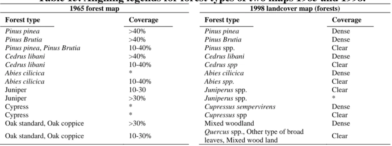
Table 15. Aligning legends for forest types of two maps 1965 and 1998. 100
Table 16. Forest legend generalization on both maps 1965 and 1998. 100
Table 17. Fast summary of materials used and their purposes. 112
Part III. Results
Chapter 5. Fifty years of forest cover changes
Table 18. Forest types of Lebanon and their total area in 1965. 117
Table 19. Changes in landscape pattern indices for forest types in 1965-1998. 122
Table 20. Landscape pattern changes at the two parts of Lebanon in1965-1998. 122
Table 21. Forest change between 1965 and 1998. 124
Table 22. Confusion matrix for classification of 1987 Landsat TM and 2003 Spot 5 satellite images using six categories of landcover.
142 Table 23. Estimated area of landcover types (class area, CA) in 1965, 1987 and 2003 in
the study area.
143
Table 24. Transition matrix of forest patches over the studied periods. 146
Table 24. Continue. 147
Table 25. Landscape metrics for the observation years. 150
List of Figures
PART I. Literature Review
Chapter 1. Forests and the Mediterranean
Figure 1. Mediterranean forests, long history of human interrelation. 12
Photo 1. Oak forest cutting for firewood in Lebanon. 13
Figure 2. Evolution of studies at the Mediterranean forests. 14
Figure 3: a) Four landscapes with same amount of habitat (in area) but with varying levels of fragmentations, when measuring patch size and edge length. Average patch size declines from (A) to (D), while edge length increase. b) As habitat availability declines, the component of fragmentation changes from perforation in (A) to isolated fragments in (D); habitat patch size decrease, edge length increase, and habitat patch isolation increases.
16
Figure 4. Attempts to discover fragmentation consequences. 22
Figure 5. Percent distribution of forest types in Lebanon. 26
Figure 6. Forest types of Lebanon following the 1965 forest map; relation to Mediterranean forests.
27
Chapter 2. Landscape spatial configuration analysis
Figure 7. The three spatial components or elements of landscape. 34
Figure 8. Spatial patterns of landscapes. 37
Figure 9. Three types of problems in landscape analysis with pattern metrics: conceptual flaws, improper uses, and inherent limitations of landscape indices. Each type manifests in several forms that overlap with the other types.
42
Part II. Materials and Methods
Chapter 3. Materials
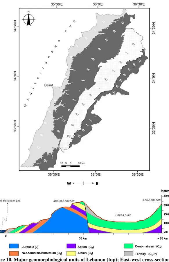
Figure 10. Major geomorphological units of Lebanon (top); East-west cross-section across Lebanon (below).
52 Figure 11. Location of the study area. (Background: Landsat image of 1989, band
combination Red = 4, Green = 3 and Blue = 2).
54
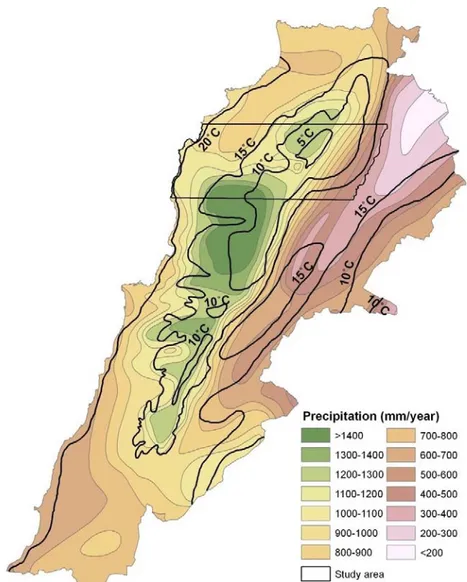
Figure 12. Precipitation rate (mm per year) in Lebanon. 57
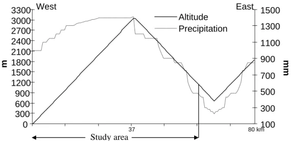
Figure 13. Precipitation-altitude relationship across the study area includes the highest altitude in Lebanon (3080m).
58
Figure 14. Mean annual temperature depends on altitude as well as yearly rainfall rate. 59
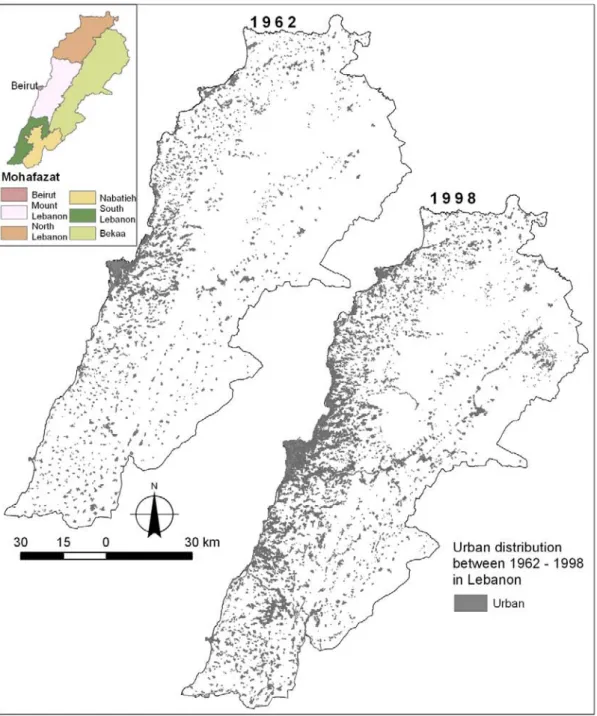
Figure 15. Urban distribution overall the Lebanese territory between 1962 and 1998; Administrative distribution in Lebanon (top left).
61
Figure 16. Population distribution over Lebanon. 62
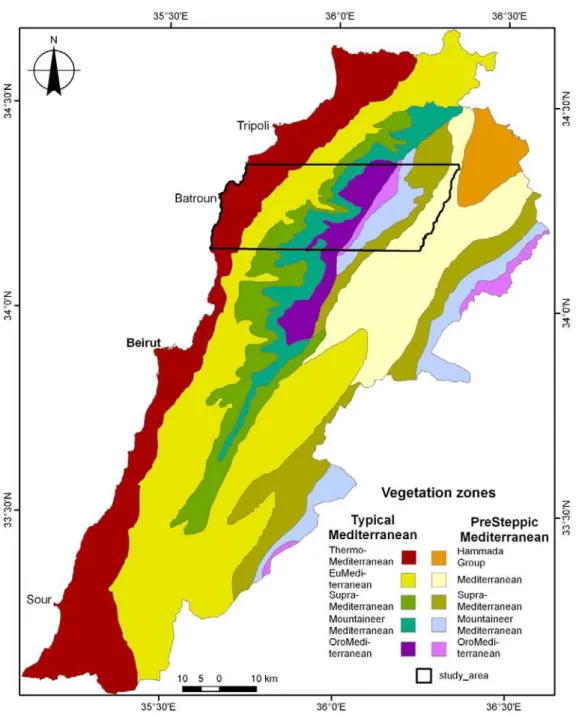
Figure 17. The study area across the main vegetation zones of Lebanon (modified from Abi Saleh and Safi, 1998).
64
Figure 18. The existing vegetation zones in the study area. 65
Figure 19. Topographic profiles along the study area (1 to 4). 67
Figure 20. Geological characteristics at the study area. 70
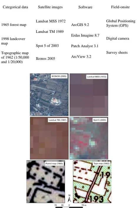
Figure 21. Time scale and periods for landscape analysis and forest change investigation at the study area depending on data availability (05 means 2005).
73 Figure 22. Different used materials; and the original datasets used have varying spatial
resolution and include MSS (80 m), TM (30 m), IKONOS (0.80 m) and Spot 5 (10 m) images. Forest map (1/50,000)and topographic (1/20,000) were also used.
Figure 23. Field observation points over the study area. 82
Chapter 4. Methodology
Figure 24. Preparation forest GIS layers from the 1965 forest and topographic maps. 88
Figure 25: Followed steps to obtain forest cover map. 89
Figure 26. Legends for the vegetations on the topographic map, demonstrating woods and shrubs.
99
Figure 27. Classification of the satellite images, the followed steps. 102
Figure 28. An example of patch degree of complexity using our developed index. 108
Figure 29. Slope gradient calculation and slope aspect divisions. 110
Figure 30. Setting the scale and drawing details between trees. 111
Part III. Results
Chapter 5. Fifty years of forest cover changes
Figure 31. Forest types distribution along the coastal and inner part of Lebanon, comparing 1965 to 1998.
118 Figure 32. Variation of forest patch size in Lebanon; the numbers on top of each bar are
patch numbers for each patch size range.
119
Figure 33. Forest type changes between 1965 and 1998 in coastal part (a) and inland (b). 120
Figure 34. Different forest types presence-probability with regard to slope gradient and aspect, coastal part.
125
Figure 34. continue. 126
Figure 35. Forest types on slope gradients and aspect at the presteppe vegetation zone, inner lands.
126
Figure 35. continue. 127
Figure 36. Forest types presence probability with relation to vegetation zones. 127
Figure 36. continue. 128
Figure 37. Forest types distribution on the different vegetation zones of the presteppe Mediterranean ensemble of Lebanon.
128
Figure 37. Continue. 129
Figure 38. Forest type-geology interrelation in Lebanon. 129
Figure 39. Slope gradients and aspects at coastal Lebanon. 130
Figure 40. Forest loss between 1965 and 1998 compared to different spatial indices. 132
Figure 41. Forest patches direction in Lebanon. 133
Figure 42. The three situation demonstrating differences between forest map of 1965 and topographic map of 1963 and the way of resolving these variations into improved new forest map of 1965.
136
Figure 43. Absence of forest patches of forest map (A); appearance of the patches on topographic map (B); comparison to Spot 5 satellite image of 2003 (combination red=b1; green=b2 and blue=b3).
137
Figure 44. Forest patches delineated as dashed lines on the forest map of 1965 was shown as aggregation of small patches on the topographic map (on screen representation of satellite image in combination red=b1; green=b2 and blue=b3).
137
Figure 45. Both original and mended 1965 forest map. 138
Figure 46. The forest area difference between both 1965 forest maps before and after correction.
139 Fig. 47. Visual comparison between forest map of 1965, aerial photos of 1962 and
satellite image of Spot 5 (color composition: R = green band, G = red band and B = near infrared band).
140
Figure 48. Variation in the spatial configuration of forests in 1962, 1965, 1972, 1989, 1998 and 2003.
144
Figure 49. Area in hectares of 2003 patches located outside 1965 forest patches (top). Number of patches in 2003 located in each 100 m distance band outside the 1965 forest patches (bottom).
149
Figure 50. Comparison of forest types Patch Number and Mean Patch Area in the investigated years.
152
Figure 51. Occidental forests (coastal part) loss with relation to spatial indices. 153
Figure 52. Oriental forests (coastal part) loss with relation to spatial indices. 153
Figure 53. Occidental (a) and oriental (b) forests loss with relation to topographic complexity.
154
Figure 54. Junipers delineation on 1/20000 spatial scale. 156
Figure 55. Degradation of forest patches based on the distance (m) between forest patches and urban settlements in 1962.
158
Figure 56. Linear features detected on the inside of the forest patch. 159
Figure 57. Intrusion and dents in a forest patch. 160
Figure 58. Forest fire events happened between 2003 and 2005. 161
Figure 59. Oak forest regeneration in short period. 162
Figure 60. Oak forests of the highest density of cover on both parts of the study area. 163
List of abbreviations
AWMPFD Area Weighted Mean Patch Fractal Dimension
BV Brightness value
DEM Digital Elevation Model
DN Digital number
ED Edge Density
EL Edge Length
Freq. Frequency
GIS Geographic Information System
IFOV Instantaneous Field of View
IPAR Intercepted Photosynthesis Active Radiation
LCCS Land Cover Classification System
LPI Largest Patch Index
MLC Maximum Likelihood Classification
MNN Mean Nearest Neighbor
MPS Mean Patch Size
NDVI Normalized Difference Vegetation Index
PN Patch Number
Psls Patch strip like shape
RD Road Density
RMSE Root Mean Square Error
RTF Relative Number of Topographic Faces
STD Standard deviation
TE Total Edge
3
General introduction
Forest loss and the concomitant fragmentation are among the most important environmental issues that have been threatening biodiversity worldwide. Fragmentation processes could be reflected by increasing habitat isolations (Debinski and Holt, 2000; De Luis et al., 2006), changing forest spatial configurations (Bélanger and Grenier, 2002; Jha et al., 2005), endangering species (Collevatti et al., 2001), negatively alter species richness (Gigord et al., 1999) and modifying population dynamics (Watson et al., 2004). Fragmentation also causes remnant vegetation patches to vary with time since excision from previously continuous forest (Turner, 1996). Since ecological integrity is a function of changes that occur in spatial or pattern configuration imposed on a landscape (Cayuela et al., 2006), fragmentation breaks environmental equilibrium. Fragmentation studies stand on the growing theoretical and empirical framework that links biological processes to landscape configuration and composition.
The explicit relationship between forest fragmentation and biodiversity encouraged scientists to develop forest monitoring and spatial analysis tools. Indicators have been developed to describe landscape and forest fragmentations through quantifying changes (O’Neil et al., 1988; McGarigal and Marks, 1995; Riitters et al., 1997). In this respect, remote sensing and geographic information system (GIS) help to perform detailed structural characterization and quantification of landscape spatial patterns in recent decades. The combination of remote sensing, GIS and landscape spatial analysis has offered managers, conservationists and scientists the possibility of making faster decisions and conclude better results.
Mediterranean Basin countries differ widely in their forest coverage, ranging from the lowest in Egypt (0.07%) up to the highest in Portugal (41%). While in Lebanon, the latest forest cover information reveals the existence of 13% coverage (MoA and FAO, 2005a). However, some literatures estimated this cover by 8% (Abi Saleh et al., 1996). This discrepancy in quantifying total forest cover is a result of using different spatial scale maps or different forest definitions (e.g. Abi Saleh and Safi, 1988; MoA and FAO, 2005b). Whichever, Lebanon appears to have average forest cover among other countries in the Mediterranean Basin.
4 Like many countries of long civilizations history, Lebanon is suffering from severe forest fragmentation. Pabot (1959) explained, based on years of field observations, that natural vegetations around Lebanon are under sever degradation status, because of deforestation, grazing and erosion processes. Nowadays, a faithful status of the forest cover in Lebanon is in deep vagueness, because the prevailing studies have mainly used one index for describing the forests, i.e., total forest cover change.
Landscape ecological investigations, on the other hand, offered important landscape indices that should also be considered while studying forests. Landscape metrics in Mediterranean forests could be useful in establishing a landscape-monitoring program, to detect the local drivers of biodiversity, and to improve management decisions (Schindler et al., 2007).
Even though efforts to quantify patterns of landscape began in the 1980s (Krummel et al., 1987; O'Neill et al., 1988), their application in the Mediterranean ecosystems is considered minim. Thus, landscape spatial indices have to be tested for their eligibility in the Mediterranean and especially for predicting future changes and understanding forest behavior.
Lebanon has significant floristic diversity because of its geographical location and its high variability of abiotic conditions. In addition, the country is characterized by significant landscape diversity that is the result of topographic and physiographic nature thus a millennia of human interference. This wealth in biodiversity is at risk, because of the continuous land degradation and, especially forest fragmentation. Forests in Lebanon are being fragmented by both anthropogenic and natural causes. Nowadays, these forests are considered as fragments and residual patches.
The chaotic expansion of urban settlements and agricultural practices has exacerbated the depletion of natural resources (Talhouk et al., 2001). Quarrying is also taking over the forest cover when counting 710 quarries distributed around the limited territory of Lebanon (Dar el Handassah, 1996). Studies focus on forests changes and biodiversity in Lebanon do not even mention fragmentation of forests (e.g., MoA and FAO, 2005a). Fragmentation processes are not documented where only forest mapping and the consequent total landcover change are the concern of many institutions.
5 Since only few fragments of different forest types remained at various altitudes around Lebanon, conservation efforts must focus on the remaining forest fragments, and more information is needed for their management. In addition, describing the pattern of forest fragmentation should be among the priorities on the road for sustainable forest use.
Lebanon is one of the countries that signed and ratified the Convention on Biological Diversity (CBD) in 1994. The CBD provides an international framework for conservation of biodiversity. By signing the CBD, Lebanon agreed to take actions in reducing the current rate of biodiversity loss by the year 2010. Achieving this target requires rapid and cost efficient methods to monitor, inform, assess and quantify changes in landcover and biodiversity.
The main question is: did we extract yet from the existing spatial data on forest in Lebanon enough information? The forest spatial information in Lebanon could be divided between maps (spatial distribution data) and descriptive discussion of a spatial perspective (vegetation levels and forest relation to geological formations). The country printed forest maps are for the years 1965, 1966, 1988 and 2005. Other spatial data could be extracted from the 1990 and the 2002 landcover maps. This quantum of the spatial data gives an impression that Lebanon is wealthy with regard to forest spatial data but this data is still incoherent. The unpleasant truth underlies behind the source of data used to obtain these maps. We should not also forget the different spatial scale and the variability that resides in authors' perspectives that adds to the differences between categorical maps. Accuracy of spatial information is also a major problem, which must be considered.
The other question is: do the existing spatial data offer the possibility to extract beneficial ecological information? Concerning forests, the existing spatial data has relatively long enough time span to start the ecological analysis. The first spatial forest data is dated back to the 1960's, where the landscape spatial patterns could largely change. The spatial configuration changes characterize these spatial patterns are one important ecological aspect.
The main objective in this research is to understand forest fragmentation for different forest types as an important landcover change process in Lebanon through:
6 1- Examining the applicability of landscape indices on forests of Lebanon
- Forest fragmentation on landscape and class levels. - Detecting future changes using landscape indices.
- Detecting forest regeneration, together with spatial pattern configuration.
- Hemerobiotic state of forest types and each forest patch, effect of spatial configuration (investigating lineament features inside forests, human interferences and roads).
2- Knowing the causes of fragmentation through studying the: - Urban approaching forest patches
- Transition matrices of forest patches (landcover change inside old forest patches)
3- Investigating the added value of remote sensing on landscape spatial configuration analysis, by using:
- NDVI to detect regeneration of oak forests
- NDVI to differentiate oaks in coastal and inner parts of Lebanon
4- Investigating the degree of connectivity between patches using topographical characteristics
- Topographic features (number of slope gradient and aspects between patches will explain how smooth is the connectivity between patches).
5- Establishing a standard representation of Juniper forests that will facilitate future monitoring, and solving the discrepancies and problems facing this forest delineation and mapping in Lebanon.
7 This research is organized in four parts as follows:
Part I.
This part includes literature review relevant to the research topic. It is organized in two chapters:
Chapter 1 addresses the ecological problems of the Mediterranean forests, research needs and characteristics of this forest ecosystem; forests of Lebanon were also described with little history of the related studies.
Chapter 2 handles the landscape spatial pattern theories and main usages. It also explains the role of remote sensing in landscape spatial pattern analysis
Part II.
This part includes two chapters tackling the study area, materials used to accomplish this research and the methodology designed to reach the research objectives.
Part III.
This part includes the results in one chapter that handles first results for forest changes on the entire country; and then includes detailed forest analysis on a selected area of
Lebanon.
Part VI.
This part first discusses the obtained results and then constructs the conclusion related to the entire work.
Part I.
Literature
Review
11
CHAPTER 1
1. Forests and the Mediterranean
This chapter establishes an overview of literatures for utilizing landscape spatial analysis approaches on Mediterranean forests. The spatial characteristics of the Mediterranean landscapes and forests were clarified, with emphasis on factors affecting forest fragmentations, especially those that are rarely studied. Evolution of forests in the Mediterranean was tackled and especially in Lebanon. Knowledge on forests resources in Lebanon was brought where the importance of our research emerges. The theories behind landscape spatial analysis were thoroughly undertaken, while first important terms in landscape analysis approach (like landscape, patch, corridors, etc) were refined. This allowed us to explain the different tools related to landscape spatial analysis. Problems and difficulties related to the use of such tools (landscape metric, remote sensing) were also explained.
1. Mediterranean forests and research needs
In the Mediterranean Basin, a relatively wide range of climatic conditions occurs, from arid to humid environment (Quézel, 1985). The presence of fragmented and steep mountain slopes and profound valleys on various geological substratums multiplies the climatic heterogeneity and creates microclimatic conditions.
Mediterranean forests are heterogeneous, therefore, on their biotic specificity, which is based on the diversity of abiotic factors mainly geographical, geological, geomorphological, pedological, and bioclimatic (Quézel, 1974; Casazza et al., 2005). Ecosystem processes may also be contrasting even when they are associated to the same species. For example, natural ecosystems in Lebanon face climatic and microclimatic variability within short distances. For example, Quercus calliprinos behaves completely different, comparing the typical Mediterranean-to-Mediterranean presteppe floristic ensembles.
12 In Mediterranean ecosystems, natural vegetations often consist of shrub species that grow within a matrix of herbaceous plants, mainly annuals. Mediterranean forests are divided into different vegetation groups (Quézel and Médail, 2003), such as broadleaf (evergreen and deciduous) and coniferous trees. Most of the broadleaved forests are of sclerophyllous type, which they are named differently all-around the Mediterranean regions. They are called chaparral (California), matorral (Spain), maquis (France and most of Mediterranean countries), Macchia (Italy), fynbos (South Africa), or kwongan (Southwest Australia). The degraded form of maquis is scrubland named garrigue (in France).
Since the dawn of civilization, Mediterranean forests have undergone spatial structural changes, but this process was slow, long and relatively sustainable. Recently, human-nature balance has been broken and lost. Forests are now fragile and under complete threat of extinction (Figure 1). Fragmentation of the landscapes is decreasing the chance of large forests to reestablish. It is the destiny of these forests to stay fragmented in isolated islands. Large wild animals, which require large forest areas, will probably never host this area again unless major changes occur in human policy and even though it will require a long time.
Figure 1. Mediterranean forests, long history of human interrelation (prepared in this manuscript).
Mediterranean Basin is a perfect example of strong landscape and ecosystem changes (Vogiatzakis et al., 2006). A long list of human-induced changes could be drawn, e.g.,
Continuous and large forests Paleolithic period Neolithic period Deviation from climax Forests are under cutting processes Forests is facing fragmen-tation
Forests are under continuous spatial structural changes (highly fragmented forests) Civilizations Time 200,000 BP 12,000 BP 3,100 BCE Modern civilization span 20th century
13 agriculture, cutting, overgrazing, urban expansion, etc (Photo 1). Thirgood (1981) discussed that the spread of agricultural practices and animal grazing, the need of wood for shipbuilding, constructions and heating, the devastation by wars, all reduced the extent of the forest cover, resulting in progressively open and degraded woods, and, thus, bare land with eroded slopes, especially in mountain areas. Herbivores might indirectly affect the spatial pattern of the forests (Seifan and Kadmon, 2006). Spatial structure of natural vegetations is also affected directly by grazing or through modifying spatial structure of palatable species (Huntly, 1991).
Photo 1. Oak forest cutting for firewood in Lebanon (photo shot on April 29, 2005 at
Kefraya north Lebanon "coordinates: x = 35.722988; y = 34.2954694; z = 226 m").
Natural causes are also highly active in disturbing forest ecology, in the Mediterranean region, mainly the climate change and fire and other natural hazards. Mediterranean forests became coppices-like form because of long history of human interference especially the cutting processes (Crowther and Evans, 1986). Mediterranean forests are highly sensitive to climatic changes (Peñuelas et al., 2004). For example, some climatic models show an important decrease in water availability in semi-arid areas
14 of the Mediterranean, thus causing dramatic changes of the natural ecosystems (Jones et al., 1996; Vicente-Serrano et al., 2006).
These changes occur with different magnitude in the diverse area of the Mediterranean Basin. Eastern Mediterranean forests are facing drastic phenomenon of desertification where recent bioclimatic and biological trends indicate such phenomenon (MoA, 2003). While, southern Mediterranean has already faced changes from sub-humid to semiarid bioclimatic level (Barbero and Quézel, 1995). Due to high human intervention and many other factors, e.g., most Mediterranean forests can be considered as patches in different stages of development (Kruger et al., 1983). These forests are unique in nature and possess extensive problems with regard to other region of the world. In the old days studies at the Mediterranean forests were limited to plant collectors and then to botanists (Figure 2). After a physiognomic phase, phyto-geographers have investigated the Mediterranean forests where they deeply searched into the particularity of the area (Di Castri, 1981; Ozenda, 2002). The bioclimatic zones brought to the hands of the phytosociologists and the vegetation associations were described. At the Mediterranean landscape, spatial analysis is in its infancy and in various places remains missing, such as Lebanon.
Figure 2. Evolution of studies at the Mediterranean forests (prepared in this manusprit). 1890 Time span - Use of forest resources 1926 Physiognomic Phase - The campestral appearance of the landscape 1970's Phytogeographic and phytosociologic phase; physiognomic - Understanding the specificity of the area - Biogeographic divisions - Terminologies characterizing the Mediterranean forests - Vegetation series and associations 1980 Landscape spatial analysis - Explicitly understanding the spatial complexity of the forests ♦ required to answer: - Applicability of Landscape indices
- Spatial pattern relation to processes and lower levels of biodiversity - Plant collectors (Herbier) plus the start of botanists
15 Although landscape changes in the Mediterranean basin have been recently studied, yet most of those studies focused on quantifying the rate of land abandonment (García et al., 2005), forest expansion or fire effects (Moreira et al., 2007). One of the research priorities suggested for Mediterranean forests is “to study structural and functional interactions between landcover management and biological diversity at the level of forest stands and of the landuse mosaic” (Scaracia-Magnozza et al., 2000). Since natural and anthropogenic factors play major role in shaping the ecology of Mediterranean forests, better knowledge is needed about the landscape spatial behavior of the forests.
Biodiversity in Mediterranean forests has not only spatial character, but also a temporal one. There are convergences and divergences among different Mediterranean regions with regard to biodiversity because of palaeogeographical (Verlaque et al., 1997) and historical factors as well as ecological conditions (Quézel, 1985). Mosaic landscapes are common, where different patches of vegetations are found interleaved on various soils, topography, exposure to wind and sun, and fire history. For example, Beirut-Damascus (40 km) trajectory holds similar or higher number of species compared with the trajectory of Paris-Marseille (Mouterde, 1966).
2. Forest fragmentation
Fragmentation is an intuitive concept where it involves dividing something into a number of smaller pieces. Generally, the number, size and spatial distribution of the resulting pieces characterize fragmentation. A plate that is broken into 100 pieces is more fragmented than if same plate were broken into 10 pieces. Similarly, a plate broken into 10 pieces of equal size is more fragmented than a plate broken into 10 pieces, one of which is 90% of the original plate.
Forman (1997) defined the process of fragmentation as “the breaking up of a habitat, ecosystem, or landuse type into smaller parcels”. Fragmentation is a term used for the reduction or elimination of patches or connections between patches in a landscape (Kotliar and Wiens, 1990). Habitat fragmentation, ecosystem fragmentation and forest fragmentation are different terminologies used in ecological sciences. The separation of
16 these three terms requires further ecological understanding and clearly accurate definitions in ecology. Habitat fragmentation and forest fragmentation are sometimes confused with each other. Therefore, fragmentation has become a generic concept in ecology and its utility is under questioning (Bunnell, 1990). The term fragmentation has not been used consistently. Some studies include habitat loss as part of fragmentation; others consider it as a separate change. For example, habitat amount (total area) within a landscape might remain constant but the extent of habitat fragmentation changes; or both increase simultaneously (Figure 3).
Figure 3: a) Four landscapes with same amount of habitat (in area) but with varying levels of fragmentations, when measuring patch size and edge length. Average patch size declines from (A) to
(D), while edge length increase. b) As habitat availability declines, the component of fragmentation changes from perforation in (A) to isolated fragments in (D); habitat patch size decreases, edge
length increases, and habitat patch isolation increases.
An organism (or community) will survive until loss of habitat reaches a specific threshold. This threshold depends on the region and the environment of the study. Habitat fragmentation increases the chance for a species (organism or community) to reach the threshold of mortality when loss of habitat occurs. However, the concept of threshold is
A B C D
A B C D
b a
17 questionable (Lindenmayer et al., 2005). Consequently, studies started to separate habitat loss from habitat fragmentation (Fahrig, 2001).
Habitats are areas that provide the resource requirements for discrete phase of a plant or animal’s life (Southwood, 1981; Pacha and Petit, 2008). Habitat-area, on the other hand, is the amount of habitat within a landscape that meets the requirements of particular species. Habitat fragmentation could be defined as the emergence of discontinuity in an organism’s (or number of organisms, or community) preferred environment (habitat).
Ecosystem fragmentation is the breaking of an ecosystem. For example, floodplain ecosystems are fragmented by eliminating the hydrological connectivity between different parts of the ecosystem (Thoms et al., 2005). Ecosystem mainly used to mean forest woods or other natural patches (Gibson et al., 1988; Geneletti, 2004). The term ecosystem is ambiguous in ecology; therefore, we preferred the terms forest loss and fragmentation.
Forest fragmentation is a form of habitat fragmentation, occurring when forests are cut down in a manner that leaves relatively small, isolated patches of forest. The intervening matrix that separates the remaining woodland patches can be natural open areas, farmland, or developed areas. Following the principles of island biogeography, remnant woodlands act like islands of forest in a sea of pastures, fields, subdivisions, urban settlements, etc.
The formation of heterogeneous mixture of small forest patches is an intermediate step in continuing fragmentation (Reed et al., 1996). In severe ecological conditions, fragmentation progresses in various degrees; initially a patchy forest is transformed into fragmented one then to a number of forest fragments and finally to a singular insular tract
or forest patch.
Forest fragmentation is a symptom that describes the illness (disorder) of a landscape. As forest fragmentation expands over a landscape, landscape biodiversity and integrity (biodiversity within the landscape) are threatened.
For simplicity and to facilitate the utilisation of terms, we use in this research forest fragmentation as the breaking of a forest patch into several discontinuous patches. We also use the term forest loss to describe area diminishing of one or several forest patches.
18
2.1. Causes of fragmentation
Fragmentation might be the result of either natural disturbances such as spontaneous fire (e.g. forest fragmentation increase fire risk and vice versa, e.g., Eriksson et al., 2003), diseases epidemics (insect outbreaks, fungus, etc), drought, mass movements, landslides, storms, climate change (Iverson et al., 1999) etc or artificial interference (anthropogenic disturbances) through clearing for agriculture (Santos et al., 2002) and urban encroachment, socioeconomic and policies (drivers of forest fragmentation see Alig et al., 2005), road construction, logging, clearcuts, grazing, introduction of alien/exotic species etc.
Pahari and Murai (1999) demonstrated the presence of high correlation between human population density and cumulative forest loss for a region. Changes in forest fragmentation correlate to the surrounding human landuse (Abdullah and Nakagoshi, 2007). For example, the fragmentation of the green belt around Moscow was the result of urban expansion (Boentje and Blinnikov, 2007).
Forest fragmentation is a phenomenon that threatens biodiversity worldwide. Lebanon is among the places where forests are subjected to severe fragmentation processes of natural or anthropogenic causes. Hence, extensive clearing for human settlements and agriculture has been carried out throughout history (Thirgood, 1981). In addition, population growth, urbanization, economic developments and conflict are among the external factors that significantly affect forests. Additionally, fire, overgrazing and over-cutting of wood products have contributed to forest degradation (MoE, 2001). For example, junipers and oaks are preferentially felled for charcoal production. Overgrazing is mainly in these two forest types at the presteppic environment where biodiversity is fragile. The stone pine (Pinus pinea) is mainly threatened by urban development and forest fires (Table 1). Pests and diseases also threaten the forests in Lebanon (MoE/LEDO, 2001). Forest holding stands of Ceratonia siliqua L. is described as highly fragmented (Talhouk et al., 2005).
19
Table 1. Threats to forest types in Lebanon based on degree of severity (listed in MoE, 2001).
Forest type Abusive
felling Overgrazing
Urban
expansion Fires
Kermes Oak* (Quercus calliprinos) 3** 4 3 3
Haired Oak (Q. cerris) 4 4 4 -
Aleppo pine (Pinus halipensis) 3 3 4 5
Callebrian pine (P. brutia) 3 3 3 5
Stone pine (P. pinea) 1 2 4 3
Cedar of Lebanon (Cedrus libani) 2 2 1 -
Fir (Abies cilicica) 3 4 3 -
Junipers (Juniperus excelsa) 4 5 2 -
Cypress (Cupressus sempervirens) 3 4 2 2
* Quercus infectoria could be found as mixed forest with Q. calliprinos. **Numbers are used as a scale of occurrence; low value means lower occurrence.
Another major cause of forest fragmentation in Lebanon is roads and other linear features, which require to be investigated thoroughly as it is the major threat to biodiversity.
2.2. Avoided and ignored fragmentation analysis
Landuse is rapidly changing forced by the socioeconomical variations. This has resulted in continuous transformations of the landscape. While depopulation and abandonment of agriculture is happening in one place, other areas are facing overexploitation of lands. Understanding the changes of the spatial distribution of vegetation cover is very important in such areas. This may help conduct better management models that human-nature relation can be sustained.
Man has constructed large road networks in order to maximize energy and benefit through using the landscapes with minimum labor investment. Roads and other passage types are among the major disturbances that cause important forest spatial changes. For example, roads disturb the diversity of birds within forests even if composition and structure might appear similar (Forman and Deblinger, 2000; Saunders et al., 2002). Therefore, within patch disturbance might minimally affect composition, spatial characteristics and structure but it highly disturbs special processes and life forms. Linear object and features are rarely added in a spatial landscape analysis study because of the
20 low spatial resolution of the data source. For example, the frequently used data source, Landsat images, roads within forest patches are not detected.
Roads dissect vegetation patches, create edge effects, increase the uniformity of patch shape and size, and serve as barriers to species with limited mobility, invasion routes for weedy exotics, and direct sources of mortality to other species.
Clearcuts and roads alter the structure and function of forests by reducing forest cover, increasing edge density and isolate trees (Reed et al., 1996). They also decrease core area and fundamentally change the size and shape of the patches (Tinker et al., 1998). The number of forest patches increase followed by decreasing its size when linear features are added to fragmentation analysis (Geneletti, 2004).
Riitters et al. (2004) found that an assessment of fragmentation without incorporating road maps is potentially incomplete. On the other hand, incorporating only roads in fragmentation studies potentially ignores the effect of other linear features such as streams, grazing crossing roads and power transmission corridors.
Hemeroby or hemerobiotic state is an integral measure for the anthropogenic influence on landscapes or habitats. Jalas (1955) introduced this term in ecology to classify plant species according to the degree of the share in neophytic species. Hemeroby was then defined as “an integrative measure for the impacts of all human intervention on ecosystems, whether they are intended or not. The degree of hemeroby is the result of the impact on a particular area and the organisms which inhabit it” (Sukopp, 1976 in Fu et al., 2006). Hemeroby of a forest patch is negatively altered with increasing human influence (Steinhardt et al., 1999). The degree of hemeroby is measured by indicators such as the share of neophytic and therophytic species, morphological and chemical soil features and landuse types. Hemerobiotic measurements were used in the field of ecology in Central Europe and in China (Zechmeister and Moster, 2001; Fu et al., 2006). Landuse intensity and landscape pattern changes can be attributed by the hemerobiotic state. As a measure for naturalness or conversely the human influence on ecosystem, hemeroby can be used for the assessment of ecological sustainability. The deviation of landscape compared to average situation is the hemerobiotic degree of that landscape (Peterseil et al., 2004).
21 We will use hemerobiotic state of a forest patch to measure the degree of human interference in changing sustainability. Roads and linear features within a forest patch are major changes that we considered that they change the hemeroby of forests.
2.3. Consequences of fragmentation
Many studies demonstrated that landscape biodiversity and ecological conditions are negatively influenced by fragmentation of landscape patterns (Paton, 1994; Beir and Noss, 1998; Mazerolle and Villard, 1999; Hill and Curran, 2005). Fragmentation could
lead to (i) accelerate local and global extinction of plants and animals (Farina, 1998); (ii)
reducing species number; (iii) the interference in dispersal and migration processes; (iv) alter ecosystem inputs and outputs; (v) the exposure of isolated core habitats of the forests; (vi) interrupt nutrients, plants and animals flow between landscape ecosystems (Lovejoy, et al., 1986; Baranga, 2004); (vii) changes in landscape spatial pattern configuration.
Fragmentation actually modifies biodiversity through four main mechanisms (Noss and Csuti, 1994):
1. Initial exclusion: when the fragments still hold most of the initial forest species. 2. Isolation: when the landscape becomes mostly inhospitable for native taxa. 3. Island-area-effect is when the smaller fragment has rapid extinction phenomenon
of biodiversity.
4. Edge effect: when the core area of the forest reduced and the edge permits the entrance of invaders.
Consequently, fragmentation affects ecosystems by altering both abiotic and biotic factors. The flow of resources (organisms, nutrients, etc) changes between and within fragmented patches because it depends on the size, number, shape and configuration (monitored through techniques of remote sensing) of patches within landscapes (Figure 4). As an example, light, moisture, wind, soil regimes, etc changes under fragmentation processes (Saunders et al., 2002). Patch edges receive more temperature and solar
radiation and have different moisture conditions than patch core. Abiotic factors also
22
Figure 4. Attempts to discover fragmentation consequences (prepared in this manuscript as a conceptual view of the landscape fragmentation problem).
Although the degree of forest fragmentation (as well as connectedness) is used as an indicator for the status of biodiversity, fragmentation processes effect and consequences are very complex and interconnected; field evidence and measurements remain highly required (Bissonette, 2003). Haila (2002) explains, “The effects of fragmentation vary
across organism, habitat types, and geographic regions”. As an example, large fragments
might not guarantee higher species richness (Rudis, 1995).
Forman et al., (1976) have found relationship between patch size and avifauna diversity. They spoke about a threshold allowing for the presence or absence of a species. They also pointed out that species are negatively affected by fragmentation especially at the patch edge. Other studies found that some native species require large area or have limited vagility that they will be affected easily by others able to disperse well in limited resources, such as in isolated patches (Dale et al., 1994). Forest fragmentation has also altered plant animal interaction such as the trophic level of herbivory insects (Simonettia et al., 2007). Nevertheless, forest fragmentation causes climate change (Laurance et al., 1998), and negatively affects the regeneration of juniper forests (Santos and Tellería, 1994).
The consequences of fragmentation, however, are in its childhood phase of knowledge for ecologists. More studies are required to record detailed changes on
Fragmentation of landscape patterns alters Abiotics Processes
Biotics Spatial configuration
Quantifiable through metrics Attempting to relate Anthropic disturbance Natural disturbances Ecologists
23 processes under different fragmentation circumstances and at different climatic conditions.
In Lebanon, the majority of the forest patches are facing fragmentation processes but this threat has not been yet investigated. For example, roads cross the forest patches freely and other human interference are even worse.
2.4. Mediterranean forest recovery
As known, vegetations around the Mediterranean region are mainly fragmented and are the result of under centuries of continuing stress. Vegetation recovery remains possible when, e.g., abandonment of agricultural areas and cessation of extensive grazing happen.
Regrowth forests are associated to shifting practice in short term period forest to cultivations then to land abandonment and natural regeneration of forests (Lugo and Helmer, 2004). However, regrowth forests might never assemble similar composition in flora and fauna to the pre-clearing situation of mature forest (Foster et al., 1998), especially in arid areas (Pueyo and Alados, 2007). The regeneration pathways of regrowth are strongly dependant on landuse history such as the type and duration (Bowen et al., 2007), as well as on climatic and even microclimatic conditions. In addition, forest regeneration depends on the severity of previous pests and diseases attack (Olivia and Colinas, 2007). Mediterranean forests have the potential to fast recover up to 80% post fire events in only three years period (Wittenberg et al., 2007), depending on the forest type. Broadleaved forests recovered after forest fire by 2 years whereas coniferous has died in an experimental site in Portugal (Catry et al., 2006). For example, grazing and cultivation had negative effect on regeneration of Holm Oak in Spain (Plieninger, 2007). However, oak forests in Lebanon face cutting events every 15 to 25 years for charcoal production; and though relatively rapid regrowth (sprouting) from mother tree occurs.
24
3. Forests and vegetations in Lebanon
3.1 Previous studies
Edmond Boissier was among the first botanist who studied the flora in Lebanon as part of the regional investigations between 1867 and 1884. Another survey of the flora was ready in 1896 by Post E. George under the name of “Flora of Syria, Palestine and Sinai from Taurus to Ras Mohammad”. The floral listing and investigations continued throughout the twentieth century as Louis Bouloumoy in 1930 wrote “flore du Liban et de la Syrie”. Between 1936 and 1940, Joseph-Marie Thiébaut published the “Flore Libano-Syrienne”. The 33 years work of Mouterde that was started in 1930, it was published in 1966 as Tome 1 “Nouvelle Flore du Liban et de la Syrie” (Mouterde, 1966), in 1970 as Tome 2 and in 1983 as Tome 3. Mouterde has constructed a valuable species list database and he corrected a number of previously misclassified plants. He also included the location and description of the sites that were investigated. He prepared drawings or “schema” for each plant in three volumes that are jointly used with the book. Other studies are worth mentioning that examined other individuals of the flora. In 1947, Mouterde had listed the arborescent species in the Levant. Whereas, Zohary (1961) had examined the differentiation of the oak species in the Middle East. The wild flowers was intensely investigated in the “Fleurs sauvage du Liban” (Nehmé, 1977) and in the “A thousand and one flowers of Lebanon” (Tohmé and Tohmé, 2002).
Mouterde (1947) provided some ecological information about the trees and shrubs associated with cedars in the Levant and this was the start for phytosociological studies. Basbous and de Tarade (1955) investigated the autecology of Cidrus Libani. Pabot (1959), Chouchani (1972) and Abi Saleh (1978) performed important phytogeographical, phytosociological and ecological studies. Pabot (1959) elucidated the various vegetation zones using the climatic characteristics and altitude and he listed the various vegetation types distinguishing each of the zones. However, Mouterde (1966) used quite different vegetation zones, finding that two of them were mistakenly used by Pabot precisely the subalpine and alpine zones.
25 Abi Saleh (1978) continued the work by describing and drawing limits to the vegetation zones and building an important phytosociological study in the country. Beals, (1965) provides some autecology information and communities of plants found at the cedars forests. The phytosociological studies as well as the vegetation-edaphic factors relationship were also investigated (Abi Saleh, 1976; Abi Saleh 1978; Abi Saleh and Safi 1998). Rey (1955) gave the distribution of cedar, in Lebanon, with relation to annual precipitation rate. Giordano (1956) investigated the total patch area of each forest type as well their distribution along the different altitudes. Chouchani et al., (1974) gave some interpretations of the various forest associations of Lebanon.
Because of forest changes with time, floral investigation at the species level for the same locations has to be renewed and updated information becomes necessary. Many changes occurred since then; especially to the sites where samples were collected (Tohmé and Tohmé, 2001). Plants that were observed only in Syria are now found in Lebanon. Others were demonstrated to be distributed in different places that were noticed by Mouterde and many are disappearing (Tohmé and Tohmé, 2001). New species of wild flowers are discovered. Moreover, several species of almond trees disappeared and big menace was found at both natural and cultivated ecosystems when compared to previously listed species (Mouterde, 1966).
Consciousness to the severity of floral and biodiversity degradation, Lebanon has signed the Convention on Biological Diversity (CBD) in 1992 and ratified it in 1994. Since that date, the government is committed in Article 6 of the CBD to identify, conserve and sustain biodiversity. In an attempt to pave the road for further biodiversity studies, the government of Lebanon compiled the previous knowledge and studies concerning biodiversity in nine volumes taking into account various ecosystems, i.e., aquatic and terrestrial (Khouzami et al., 1996). As part of this project, Abi Saleh et al., (1996), compiled the previous floral investigations and listed 3761 terrestrial species. Other studies described the forests in Lebanon for the sake of conservation (Abi Saleh and Safi, 1995).
Mapping the natural vegetation started choosing one type of forest trees and then continued to overcome the various landcover classes each for different purposes. In this respect, Pabot (1959) has mapped the cedar patches of Lebanon and listed the associated
plan 1/50 Leb desc but the Leb con was land with inve 200 3.2. Med area F nts. El Hus 0,000 spatia Baltaxe (19 banon on 1/ cribes the g no map wa The ecosys most impor banon. Othe iferous fore s establishe dcover map hin the fore estigation b 02 (MoA and . Forest geo Forests in diterranean. a in the coun Figure 5. Pe sseini and al scale. 966) listed /200,000 sca geographical s produced. stem and ve rtant ecosys er landcove est, etc (FAO ed in 2002 p “MOS (M est patch. F ut the map d FAO, 200 ography in Lebanon c . The broad ntry (Figure ercent distr Baltaxe (1 the main ale forest m l and the ge . egetation m stem phytos r map enco O, 1990). A (MoA/FAO Mode d’Occ Forest map hold the sa 05b). Lebanon could be div dleaved fore e 5). ribution of 965) constr woody spe map. Zohary eobotanical ap complet sociological ompasses v A more detai O, 2002). T cupation du of 2005 w ame forest p vided betw ests constitu forest type ructed the ecies found y (1973), as distribution ed in 1988 l study from very broad c iled landcov The delinea u Sol)” sho was made a patch deline ween broadl ute the high
es in Leban first map d in each fo s part of a M n of the veg (Abi Saleh m the past th classes, e.g ver map wit ated forest w the prev available af eation of the leaved and hest surface non (Abi Sa of the cou forest-patch Middle Eas getation of L h and Safi, 1 hat consider g., broadleaf th extensive ecosystem vailing tree fter extensiv e landcover conifers as of the entir aleh et al., 1 26 untry on around st study, Lebanon 1998) is rs whole f forest, e legend in this species ve field r map of s to the re forest 1996).
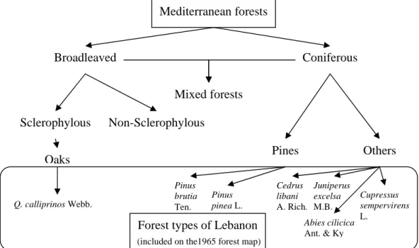
27 Forest types of Lebanon were classified under seven different homogenous patches (Figure 6). They are forests of:
(1) Quercus calliprinos Webb., (2) Pinus pinea L.,
(3) Pinus brutia Ten., (4) Cedrus libani A. Rich., (5) Juniperus excelsa M.B., (6) Abies cilicica Ant. & Ky, and
(7) Cupressus sempervirens L. (El Husseini and Baltaxe, 1965).
Figure 6. Forest types of Lebanon following the 1965 forest map; relation to Mediterranean forests (prepared in this manuscript).
The landcover map of Lebanon was produced in 2002 but it is based on satellite images of 1998. Forest types of Lebanon were generalized into six homogenous patches: (1) Pinus spp., (2) Cedrus spp., (3) Abies spp. (4) Quercus spp., (5) Juniperus spp. and (6) Cupressus spp. (MOA/MoE, 2002) Pines were joined under one forest type (forest class) if compared to previous forest map of 1965. The forest map of 2005 has more
Mediterranean forests Broadleaved Coniferous Mixed forests Sclerophylous Non-Sclerophylous Pines Others Oaks
Forest types of Lebanon Pinus brutia Ten. Pinus pinea L. Cedrus libani A. Rich. Juniperus excelsa M.B. Abies cilicica Ant. & Ky Cupressus sempervirens L. Q. calliprinos Webb.
28 generalized the forests between: (1) Pinus pinea L., (2) other pines, (3) Cedrus libani A. Rich., (4) Juniperus excelsa M.B. (5) Abies cilicica (Ant. & Ky), (6) Cupresus sempervirens L., (7) mixed coniferous forests, (8) broadleaved evergreen forests, (9) broadleaved deciduous forests, (10) mixed broad leaved forests, (11) mixed coniferous and broadleaved forests, and (12) riparian forests (MoA and FAO, 2005b).
Conversely, field data reveals another forest type that should be added onto the maps. For example, forest maps list Quercus calliprinos Webb. on places dominated by Ceratonia siliqua L (Kharroub). This tree (Kharroub) is distributed and generally found dominating forest patches of 0-500 m above sea level. Therefore, forest patches shown on previous maps must be named according to this tree (Kharroub) and not always under oaks (Quercus calliprinos Webb.). Several studies, mainly field data and observations, have found Kharroub to dominate forests of thermo-Mediterranean bioclimatic zone (0-500 m) (Chouchani, 1972; Abi Saleh, 1978; Talhouk et al., 2005). Nevertheless, field studies also prove that higher elevation forest patches of oaks (Quercus spp.) are dominated by Quercus infectoria Olivier ssp. (Abi Saleh, 1978; Abi Saleh et al., 1996). This is also another fact that has to be searched and included onto the forest maps.
Consequently, landscape biodiversity (composition of a landscape) should not only show seven forest patch types. Two other forest types must be included which they are the Ceratonia siliqua and Quercus. infectoria. Compositionally, landscapes in Lebanon holds nine different forest types.
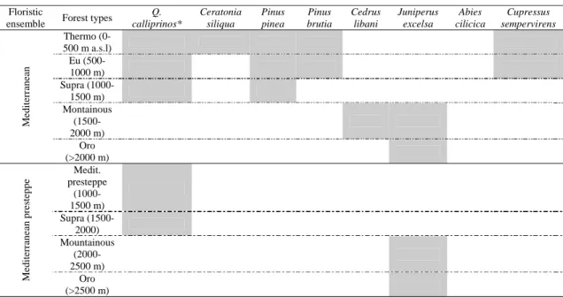
3.3. Forests abiotics relation
The distribution of forests in Lebanon is highly influenced by altitude, though it is climatically related. Lebanon was divided into ten bioclimatic zones under Mediterranean and Mediterranean presteppe climates (Table 2 and 3). As an example, Ceratonia siliqua habitat is within the thermo-Mediterranean bioclimatic zone, while Quercus callirpinos has wider range of climatic behavior.