ж ЛІ·Є»®·¬7 М±«ґ±«» н Рї«ґ Нїѕї¬·»® шЛМн Рї«ґ Нїѕї¬·»®ч ґщЛІ·Є»®·¬7 јщW¬ї¬ ј» М±іµ ЫЬ НЬЛоЫ ж Ш§ј®±ґ±№·»ф Ш§ј®±Ѕё·і·»ф Н±ґф ЫІЄ·®±ІІ»і»І¬
О·Ії¬ УїІї§°±Є
ґ«Іј· пк ј7Ѕ»іѕ®» орпнРї®¬·Ѕ«ґї®·¬7 ѕ·±№7±Ѕё·і·Ї«» »¬ ё§ј®±Ѕё·і·Ї«» ј» ґїЅ ¬ё»®і±µї®¬·Ї«»
ј» ґЋС«»¬ ј» ґї Н·ѕ7®·» ж Ф» ®,ґ» ј» ґ»«® іїЅ®±°ё§¬»
ЩЫМ у Фїѕ±®ї¬±·®» Щ»±Ѕ·»ІЅ» ЫІЄ·®±І»і»І¬ М±«ґ±«» Сґ»№ Р±µ®±Єµ§ф ШЬОфЬОоф ЛІ·Є»®·¬7 ј» М±«ґ±«»ф ЭТОНуЧЬОуСУРф Ь·®»Ѕ¬»«® ј» ¬ё8»фЪ®їІЅ» Н»®№»§ Х·®°±¬·Іф Р®±є»»«®ф ґщЛІ·Є»®·¬7 јщW¬ї¬ ј» М±іµф Э±уЬ·®»Ѕ¬»«® ј» ¬ё8»ф О«·» РїЄ»ґ Юї®«µ±Єф РёЬф ЧІ¬·¬«¬ ј» ґї °7ј±ґ±№·» »¬ ґщї№®±Ѕё·і·» ЮН ЯНОф Ої°°±®¬»«®ф О«·» Кїґ»®·§ Ж»і¬±Єф Р®±є»»«®ф ґщЛІ·Є»®·¬7 јщW¬ї¬ ј» М±іµф Ої°°±®¬»«®ф О«·» Н¬»°ёїІ» Я«ј®§ф РёЬф ґщЛІ·Є»®·¬7 Рї«ґ Нїѕї¬·»®ф ЫЁїі·Ії¬»«®ф Ъ®їІЅ» Ц»®±і» К·»®ф Р®±є»»«®ф ґщЛІ·Є»®·¬7 Рї«ґ Нїѕї¬·»®ф Р®7·ј»І¬ ј» ¶«®§ф Ъ®їІЅ»2 Résumé
Le but du présent travail – c’est étudier les particularités biogéochimiques et hydrochimiques des écosystèmes thermokarstiques du nord de la Sibérie d’Ouest pendant le procès de la dynamique naturelle du paysage et des variations climatiques modernes.
Objectif de la recherche:
1. Etudier la composition chimique des macrophytes, des dépôts de fond, des eaux de lacs et des eaux intersticielles des écosystèmes thermokarstiques du nord de la Sibérie d’Ouest.
2. Calculer les coefficients de l’accumulation biologique des éléments chimiques aux macrophytes relativement aux eaux intersticielles et les dépôts de fond pour la découverte des procès biogéochimiques se réalisant dans les écosystèmes thermokarstiques.
3. Etablir la dépendance fonctionnelle entre les concentrations des éléments solubilisés de l’eau des lacs thermokarstiques et la dimension de la nappe d’eau.
3. Etudier le gradient de latitude des concentrations de carbone organique solubilisée, des éléments micro et macro dans les eaux de lacs thermokarstiques des étapes pareilles de l’évolutions des écosystèmes thermokarstiques.
Objets d’étude. En qualité des objets d’étude ont servi l’eau de lac, les macrophytes, les dépôts de fond et l’eau intersticielle des écosystèmes thermokarstiques du nord de la Sibérie d’Ouest.
La nouveauté scientifique de ce travail:
1. On a obtenu les nouvelles données sur les cycles biogéochimiques des éléments chimiques dans les écosystèmes thermokarstiques du nord de la Sibérie d’Ouest pendant l’étude des concentrations des éléments chimiques dans les macrophytes, les dépôts de fond, les eaux de lac et les eaux intersticielles des lacs thermokarstiques.
2. On a découvert la première fois les particularités de la composition chimique des eaux de lac aux étapes différentes de l’évolution des écosystèmes thermokarstiques du nord de la Sibérie d’Ouest.
3. On a étudie la première fois les particularités de latitude de la composition chimique des lacs thermokarstiques de la Sibérie d’Ouest au profil de 900 km des glaces éternelles ce qui a permis de prévoir la modification des concentrations de la carbone organique solubilisée, des éléments micro et macro pendant les variations climatiques possibles.
Portée pratique du présent travail.
Les résultats du travail peuvent être utilisés comme les composantes de base du fond biogéochimique, relativement auxquelles on peut observer la modification de la composition
3
chimique des eaux de surface du nord de la Sibérie d’Ouest pendant l’augmentation de la charge anthropogène du territoire. Egalement les données reçues au cours du travail peuvent être utilisées pour construire les modèles de prévision de transfert des éléments chimiques et de la carbone organique solubilisée des territoires aquatiques et marécageuses du nord de la Sibérie d’Ouest dans l’Océan Glacial Arctique pendant le drainage des lacs thermokarstiques vers le système fluvial.
Mots Clés: Biogéochimie, hydrochimie, Sibérie occidentale, macrophytes, composition élémentaire.
Abstract
Objective: Study biogeochemical and hydro chemical particularities of thermokarst ecosystems in the north of West Siberia in the conditions of natural landscape dynamics and modern climatic changes.
Research tasks:
1. Study chemical structure of macrophytes, bed deposits, lake and interstitial waters of thermokarst ecosystems in the north of West Siberia.
2. Calculate the coefficient of bioaccumulation of chemical elements in macrophytes respectively to interstitial waters and bed deposits to find biochemical processes that happen inside thermokarst ecosystems.
3. Establish functional dependency between the concentration of the compounds dissoluted in the water of thermokarst lakes and size of water surface.
3. Study the lateral gradient of the dissoluted organic carbon concentration, macro- and micro elements in the waters of thermokarst lakes that have the same stages of thermokarst ecosystems development.
Targets of research. Targets of research were lake water, macrophytes, bed deposits and interstitial water of thermokarst ecosystems in the north of West Siberia.
Academic novelty:
1. New data on biogeochemical cycles of chemical elements inside thermokarst ecosystems in the north of West Siberia was received. The concentrations of chemical elements in macrophytes, bed deposits, interstitial and lake waters of thermokarst lakes were studied.
2. The peculiarities of lake water chemical structure on different stages of thermokarst ecosystems development in the north of West Siberia were revealed.
4
situated in 900 km zone of continuous permafrost were studies for the first time. This has made possible to predict the changes in the concentration of organic carbon, macro- and microelements dissoluted in case the climate changes.
Academic and practical relevance.
The results of the work may be used as the basic elements for biogeochemical background, relating to which the changes of open water biochemical structure in the north of West Siberia may be traced in case of anthropogenic load to the given territory increases. The data received during the research may be used to develop the predictive models of chemical elements and dissoluted organ carbon transfer from water-boggy land in the north of West Siberia to the Arctic Ocean when thermokarst lakes are drained into the river system.
Keywods: Biogeochemistry, hydrochemistry, western Siberia, macrophytes, elemental composition. Резюме Цель данной работы: изучить биогеохимические и гидрохимические особенности термокарстовых экосистем севера Западной Сибири в процессе естественной динамики ландшафта и современных климатических изменениях. Задачи исследования: 1. Изучить химический состав макрофитов, донных отложений, озерных и поровых вод термокарстовых экосистем севера Западной Сибири. 2. Рассчитать коэффициенты биологического накопления химических элементов в макрофитах относительно поровых вод и донных отложений, для выявления биогеохимических процессов происходящих в термокарстовых экосистемах. 3. Установить функциональную зависимость между концентрациями растворенных компонентов воды термокарстовых озер и размером водной поверхности. 3. Изучить широтный градиент концентраций растворенного органического углерода, макро- и микроэлементов в озерных водах термокарстовых озер одинаковых стадий развития термокарстовых экосистем. Объекты исследования. Объектами исследования служили озерная вода, макрофиты, донные отложения и поровая вода термокарстовых экосистем севера Западной Сибири. Научная новизна: 1. Получены новые данные о биогеохимических циклах химических элементов в
5 термокарстовых экосистемах севера Западной Сибири при изучении концентраций химических элементов в макрофитах, донных отложениях, поровых и озерных водах термокарстовых озер. 2. Впервые выявлены особенности химического состава озерных вод различных стадий развития термокарстовых экосистем севера Западной Сибири. 3. Впервые изучены широтные особенности химического состава термокарстовых озер Западной Сибири на 900 км профиле многолетней мерзлоты, что позволило прогнозировать изменение концентраций растворенного органического углерода, макро- и микроэлементов при возможных изменениях климата. Теоретическая и практическая значимость. Результаты работы могут быть использованы как базовые составляющие биогеохимический фон, относительно которых можно будет наблюдать изменение химического состава поверхностных вод севера Западной Сибири при увеличении антропогенной нагрузки на данную территорию. Также полученные в ходе работы данные могут быть использованы для построения прогнозных моделей переноса химических элементов и растворенного органического углерода из водно-болотных угодий севера Западной Сибири в Северный Ледовитый океан при дренаже термокарстовых озер в речную сеть. Ключевые слова: биогеохимия, гидрохимия, Западная Сибирь, макрофиты, элементный состав.
6 CONTENTS Résumé ... 2 Mots Clés ... 3 Abstract ... 3 Keywods ... 4 Резюме ... 4 Ключевые слова ... 5 CHAPTER 1 General introduction ... 9
1.1. Background of the study ... 9
1.2 Study sites, sampling and analyses ... 11
1.3. Cyclic development of thaw lakes on the frozen palsa peat bogs ... 12
1.4 Landscape context-based types of lakes and their chemical composition ... 13
1.5 Testing the latitude (climate and permafrost) gradient of lake chemical composition ... 17
1.6 Thesis organization ... 20
PUBLICATION ... 22
CHAPTER 2 West Siberian palsa peatlands: distribution, typology, cyclic development, present day climate driven changes, seasonal hydrology and impact on CO2 cycle ... 24
2.1 Introduction ... 25
2.2 Distribution and typology of West Siberian palsas ... 25
2.3 Elements of palsa complex morphology and vegetation ... 28
2.4 Cyclic development of palsa complex ... 35
2.5 Thermokarst lakes as an important source of CO2 to the atmosphere ... 37
2.6 Seasonal changes of hydrological conditions in the palsa regions ... 40
2.7 Present day climate driven changes of palsa peatlands in Western Siberia ... 42
2.8 Conclusions ... 44
2.9 References ... 45
CHAPTER 3 Hydrochemical composition of thermokarst lake waters in the permafrost zone of Western Siberia within the context of climate change ... 51
3.1 Abstract ... 52
7
3.3 Study sites and methods ... 55
3.4 Results and Discussion ... 57
3.4.1 Major anions, conductivity and pH ... 57
3.4.2 Dissolved Organic Carbon ... 59
3.4.3 Major and trace element concentration in thermokarst lakes ... 60
3.4.4 Trace element concentration dependence on lake diameter ... 62
3.4.5 Correlations between elements in the thaw lakes water bodies ... 63
3.4.6 Comparison of TE concentrations in the thermokarst lakes with average world concentrations in surface waters ... 65
3.4.7 DOC and metal concentration in thermokarst lakes of western Siberia across a 900-km latitude and permafrost profile... 66
3.5 Conclusions ... 69
3.6 References ... 70
3.7 Figures ... 78
3.8 Tables ... 95
CHAPTER 4 Features of the elemental composition of lake waters and macrophytes in thermokarst subarctic ecosystems of west Siberia ... 103
4.1 Введение... 104 4.2 Материалы и методики исследования ... 106 4.3 Результаты исследования и обсуждение... 109 4.4 Выводы ... 115 4.5 Литература ... 116 CHAPTER 5 Possible evolution of hydrochemical composition of the water subarctic thermokarst lakes of Western Siberia in the context of climate change ... 119
5.1 Введение... 120 5.2 Объекты и методы исследований ... 121 5.3 Результаты и обсуждение ... 122 5.4 Выводы ... 128 5.5 Литература ... 128 5.6 Рисунки ... 131 5.7 Таблицы ... 140
8 CHAPTER 6
Conclusions and perspectives ... 147 6.1 Conclusions ... 147 6.2 Perspectives ... 148
9 CHAPTER 1
GENERAL INTRODUCTION
1.1 Background of the study
The western Siberia plain comprises more than 1 million km² of peat bog and lake landsape is most likely the terrestrial system most vulnerable to on-going climate change. The main reasons for this high vulnerability include the following: (i) discontinuously distributed permafrost with very low thickness relative to Central and Eastern Siberia (sometimes less than 50 meters); (ii) the dominance of thick (up to 3 m in the south and 1 m in the north) organic peat deposits that are far more reactive than mineral soils; (iii) high coverage of the territory by tundra with patches of forest along the river valleys; (iv) abundant thermokarst (thaw) lakes that often cover up to 80% of the watershed area; (v) dense infrastructure comprising roads, pipelines and settlements linked to expanding oil and gas production. Individually, each of these factors may produce great instability in western Siberian ecosystems relative to other permafrost zones due to global warming. When combined, these factors make this site a unique battlefield between atmospheric CO2 drawdown processes (peat formation and vegetation production) and CO2
release into the atmosphere due to soil and water organic matter degradation.
Thawing of the permafrost and releasing ancient organic carbon is one of the most significant environmental threats within the global climate change scenario (Schuur et al., 2008). Solid organic matter’s degradation and subsequent conversion into gaseous CO2 is facilitated by
the liquid media. Numerous studies of permafrost degradation in subarctic Alaska (Jorgenson et al., 2011), Canada (Payette et al., 2004; Turetsky et al., 2002; Laurion et al., 2010) and Sweden (Christensen et al., 2004) have confirmed that the ecosystems are becoming wetter in the course of the permafrost disappearance.
Regardless of the mechanisms responsible for Corg → CO2(gas) conversion, this process
is enhanced in the surface waters, especially in the oxic environments. Numerous shallow surface depressions filled with thawed water and growing thermokarst (thaw) ponds and lakes in Western Siberia offer the most favorable natural environments for these conversion processes and therefore deserve thorough investigation.
The annual CO2 emission fluxes from the thermokarst lakes in Western Siberia (45±27
mol C/m²/y, Ripo et al., 2007; 8.9±4.5 mol C/m²/y, Shirokova et al., 2009) are similar to those from other thermokarst lakes and rivers in the NE European Russia (5-9 mol C/m²/y, Heikkinen
10
et al., 2004). These values are on the same order of magnitude as those for aerobic respiration in the Arctic water column, its temperate lakes (0.6 – 10 mol C/m²/y, Ramlal et al., 1994 and references therein) and lakes in Alaska (12 mol C/m²/y, Kling et al., 1992). The CO2 emission
from lakes in Western Siberia are comparable with the heterotrophic respiration of thermokarst wetlands (16 mol C/m²/y, Wickland et al., 2006) but an order of magnitude higher than the amount of CO2 emitted from the Canadian peatlands (0.73 mol C/m²/y, Turetsky et al., 2002;
0.4-1.4 mol C/m²/y, Vitt et al., 1990) and small boreal non-permafrost lakes (3.5 mol C/m²/y, Kortelainen et al., 2006). However, thermokarst lakes and ponds are important parts of the carbon budget at high latitudes because the typical CO2 emissions from a lake’s surface to the
atmosphere (110±50 g C/m²/y, Shirokova et al;, 2009 and references therein) are comparable to the typical values for the carbon sinks in peat plateaus (e.g., 106-110 g C/m²/y, Heikkinen et al., 2004). Because the newly formed lakes in the Western Siberia make up a high geographical proportion of the area (up to 48% of the surface area (Zimov et al., 1997; Hinkel et al., 2003; Riordan et al., 2006), reaching 60-80% in the Pur, Taz and Nadum river basins (Zakharova et al., 2009), there is little doubt that the Western Siberian thermokarst lakes are likely to act as a major regulator for the CO2 release from the frozen peat into the atmosphere.
Compared to large number of studies devoted to the biogeochemistry of aqueous and gaseous organic carbon forms in permafrost-affected soil and water bodies, relatively little is known regarding trace elements (TE). Recently, we have described the evolution of both the concentration and speciation of colloidal TE in the water column and in the sediments along the chronosequence of thermokarst lakes and ponds developing in the northern portion of western Siberia within continuous permafrost zone (Pokrovsky et al., 2011; Shirokova et al., 2013). However, to extend this knowledge to other boreal regions that are less affected by permafrost, studies of TE biogeochemistry in discontinuous permafrost zone under various landscape and geographical settings remain necessary. Today, it is critical to ascertain the extent that the TE’s concentration in the thermokarst lakes is controlled by the stage of lake development, the landscape (forest, tundra and bog lakes of the watersheds compared to coastal lakes for example) and latitudinal position (climate and the the permafrost thickness). Moreover, it is impossible to quantify the effect of permafrost thawing on the degree of chemical composition change of thermokarst water bodies and their potential role as greenhouse gas sources/sink under climate warming scenario, even as a first order approximation. Elucidating these issues should allow the large-scale modeling of the stocks and fluxes of the chemical elements within the aquatic reservoirs of the entire boreal permafrost-affected zone.
11 1.2 Study sites, sampling and analyses
The study site is located in the central and northern portions of Western Siberia (63.5-70.5°N, near the towns of Nojabrsk and Novy Urengoy towns, as well as the Khanymey and Tazovsky settlements), within a primarily tundra landscape that has developed continuous and discontinuous permafrost over Neocene sand and clay deposits that are covered by a 1–2 m thick peat layer (Fig. 1 A). In these regions, numerous thermokarst (thaw) lakes are observed that range in size from several hundred m² to km-sized lakes, as illustrated by the topographical map of a typical watershed divide area (the Khanumey test site used for this work) (Fig. 1 B). An aerial view of the study site also confirmed the lakes’ dominant land coverage (Fig. 1 C).
The sampling and filtration, as well as the chemical analysis, techniques are very similar to those used during our previous studies (Pokrovsky and Schott, 2002; Pokrovsky et al., 2006; Vasyukova et al., 2010; Pokrovsky et al., 2010). An ultraclean sampling procedure was used throughout the manipulations in the field (Shirokova et al., 2010). The water samples were collected in a PVC boat from the central part of the lake or manually from a depth of 30-50 cm and immediately filtered through sterile, single-use Minisart® filter units (Sartorius, acetate cellulose filter) with 5 or 0.45 μm pore sizes. In addition to the conventional filtration, in-situ dialysis experiments were performed using 20-50 ml pre-cleaned dialysis bags placed directly into the lake. This dialysis procedure lasted between 72 and 96 hrs. The filtered and dialyzed samples were stored at 4–5°C in the dark before analysis. The concentrations of dissolved organic carbon (DOC), Cl, SO4, cations and TEs, as well as alkalinity were measured using
routine methods for analyzing boreal water samples in our laboratory (Vasyukova et al., 2010; Pokrovsky et al., 2010, 2011). The dissolved inorganic carbon (DIC) concentrations were obtained from the alkalinity after a standard HCl titration procedure using an automatic Schott TitroLine alpha TA10plus titrator with an uncertainty of ±2% and a detection limit of 5×10⁻⁵ M. The DOC was measured using a Shimadzu TOC 6000 with an uncertainty of 5%. The trace elements were measured using inductively coupled plasma-mass spectrometry (ICP-MS, Agilent 7500 CE and Element XR) with indium and rhenium as the internal standards and a precision better than ±5 %.
12
Figure 1. Schematic representation of study sites: a general map of western Siberia (A), the topographical map of the main study site (Khanymey, discontinuous permafrost zone, B) and an aerial photo of thermokarst lakes field in the southern part of continuous permafrost zone (C).
The international geostandard SLRS-4 (Riverine Water References Material for Trace Metals certified by the National Research Council of Canada) was used to check the validity and reproducibility of each analysis. Good agreement was obtained between our replicated SLRS-4 measurements and the certified values (relative difference <10%).
1.3. Cyclic development of thaw lakes on the frozen palsa peat bogs
The water bodies of the Western Siberian lowland follow specific life cycles, beginning from the appearance of m²-size soil depressions and permafrost subsidences and progressing to large, mature lakes that are subjected to drainage, as illustrated in schematic diagrams with photos corresponding to each stage in Fig. 2. In the dry bottom of large drained lake, a depression and permafrost subsidence may occur, initiating a new cycle of lake development.
13
The chemical composition of thermokarst water bodies changes systematically along the timeline of lake development; the highest total dissolved solid (TDS) concentrations and dissolved organic carbon (DOC) occur at the beginning when the thaw ponds form within the permafrost subsidences and wet depressions (Fig. 2). The largest mature lake with a km-scale diameter exhibits the lowest specific conductivity (close to 10 μS cm-1, among the lowest known on the Earth surface for such a large and stable hydrological object), while the highest concentration of both DOC and metals are observed in the smaller meter-sized depressions.
Figure 2. Scheme of cyclic succession of thermokarst lakes development in discontinuous permafrost zone of western Siberia
1.4 Landscape context-based types of lakes and their chemical composition
An important observation regarding the thermokarst lakes studied in this work is that all of them have ice (permafrost) under their beds below 30-50 cm (depending on the season) of porous organic-rich sediment. As such, the lakes are strongly isolated from the mineral substrate and deep groundwater discharge at the lakebed is minimal. The latter is confirmed by the extremely low total dissolved solid concentrations in km–sized lakes. The main source of DOM
14
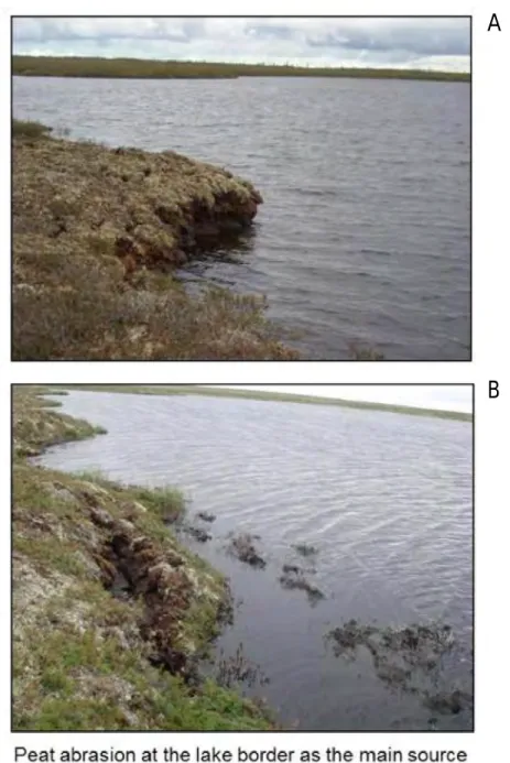
and inorganic solutes in the thermokarst lakes is the peat abraded at their borders; this abrasion may occur either by wave action or thawing/submersion actions on the portions on the border line, as illustrated by the ground photos in Figure 3 A and B, respectively.
Figure 3. Photos of the pet abrasion at the thermokarst lake border in discontinuous permafrost zone (Nojabrsk region, 2010).
In addition to the “classic” shallow thermokarst lakes most abundant in the Western Siberain arctic and subarctic, deep “primary” lakes of glacial or tectonic origin were also investigated. Figure 4 summarizes the hydrochemistry both large and small thermokarst lakes and presents the variations in the main physical and chemical parameters of two primary lakes
A
15
located within the permafrost zone; these lakes were sampled during the summer baseflow season in 2010. It can be seen from thes efigures that there is significant temperature stratification during summer season. The oxygen concentration gradually decreases from the surface to the bottom with only first 2 to 4meters being fully saturated with atmospheric O2.
Figure 4. Temperature (A) and oxygen concentration (B) depth profile of usual shallow thermokarst lakes located in discontinuous permafrost zone (rectangular) and two deep “primary” lakes of sporadic permafrost zone shown by symbols with connecting lines.
The gas regime of the two lake types is presented in Fig. 5 and the metal concentrations relative to depth are provided in Figs. 6 A-I.
16
Figure 5. Methane and CO2 concentration in shallow thermokarst lakes of western Siberia in discontinuous permafrost zone and depth profile of these gases in deep «primary» Dmitrovskoe lake (sporadic permafrost).
There is a significant difference between the specific electric conductivity of the lake water in the permafrost setting between the thermokarst and deep “primary” lakes; however, the latter exhibits one of the lowest specific conductivities known for isolated and stable water bodies on the Earth’s surface. The concentration of methane and CO2 in the deep lakes is similar to those in the shallow thermokarst lakes (Fig. 5). The metal concentrations for most of the shallow thermokarst lakes are similar or comparable to those of the deep lakes. These low concentrations of total dissolved solid and lithogenic metals in the deep lakes located within the permafrost-dominated ground support the lack of detectable groundwater feeding the thermokarst lakes’ chemical composition; the hypothesis suggested in earlier is valid for continuous/discontinuous permafrost terrain (Pokrovsky et al., 2011). The frozen state of the surrounding substrate (Neogene sands and peat deposits) is responsible for the low mineralization of surface waters in Western Siberia. The deep lakes located within the forest/forest tundra zone may also originate from large, thawed ice wedges/lenses because they exhibit extremely low concentrations of dissolved inorganic salts.
17
Figure 6. Trace metal concentration in shallow thermokarst lakes of western Siberia. See legend Fig. 4 for details.
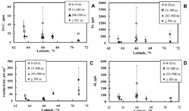
1.5 Testing the latitude (climate and permafrost) gradient of lake chemical composition
Given the large geographic coverage of the thermokarst lakes (10° latitude along a strongly pronounced gradient of permafrost thickness ranging from discontinuous and sporadic in the south of Nojabrsk district to continuous in the Gyda region), the effect of the climate or
18
latitudinal position on lake water hydrochemistry can be determined. This representation may be partially biased because the Gyda lakes are located near the sea and are thus subjected to the influences of marine aerosols depositions. For this analysis we used the geometric mean of the element concentration of the lakes sampled during the summers of 2008-2012 for four size ranges of thermokarst water bodies: depressions smaller than 10 m diameter, thaw ponds less than 100 m diameter, small and medium lakes 100 to 500 m diameter (the dominant type of water bodies in the region) and mature lakes at the final stage of their development larger than 500 m in diameter. We analyzed the major components of the lake water (DOC, Ca, Fe, Al), as well as the most environmentally important heavy metals (Zn, Mn, Cu, Ni and Pb). There are 4 distinct patterns of elemental concentrations in the lake water relative to the lake’s latitudinal position, as illustrated in Figs. 7 A-I: (i) A decrease in the elemental concentrations from the south to the north (DOC, Pb), (ii) nonsystematic concentration evolution with the latitude (Fe and Al), (iii) a maximal concentrations at the continuous permafrost sites in the continental zone (Mn); (iv) an increase in the concentrations from south to north, notably in the coastal Gyda zone (specific conductivity, Ca, Zn, Cu, Ni, and Cr). A pronounced increase of Cu, Ni and Cr concentration in the most northern region of continuous permafrost zone (Gyda site) may be due to the proximity (a distance of ~ 300 km) from the largest arctic smelter, the Cu-Ni-Cr processing factories in Norilsk.
19
Figure 7. Latitude plot of DOC (A), Fe (B), specific conductivity (C) and Al (D) concentration for lakes of different size ranges, sampled in discontinuous / sporadic, discontinuous and continuous permafrost zones.
Figure 7, continued. Latitude plot of Ca (E), Ni (F), Pb (G) and Cu (H) concentration for lakes of different size ranges, sampled in discontinuous / sporadic, discontinuous and continuous permafrost zones.
20 1.6 Thesis organisation
The manuscript is composed of the main thesis based on publications, submitted published, addressing the above mentioned objectives, and the supplementary information which comprises several extended annexes presenting analytical results.
The principal part of the manuscript comprises four chapters organized in the form of scientific articles all devoted to geochemical behaviour and forms of migration of elements in natural waters of western Siberia.
Chapter 2: West Siberian palsa peatlands: distribution, typology, cyclic development, present day climate driven changes, seasonal hydrology and impact on CO2
cycle
Palsa peatlands occupy extensive areas in Western Siberia which is one of the most paludified flat lowlands of the world. Climatic changes in Western Siberia are more dramatic compared with other northern regions, and changes in palsa landscapes are more notable due to the severe continental climate here. The distribution, peculiarities and climate-indication capacities of West Siberian palsas are poorly known outside Russia. Thus, Western Siberia is one of the most interesting vast natural polygons for studying climate-driven changes in the landscapes. This paper aims to fill the gap in knowledge on West Siberian palsas and their capacity as a climate regulator. We present issues in distribution, typology and cyclic development of palsa peatlands and their actual climate-driven changes. We also analyse the role of palsas in the atmospheric cycle of CO2, and the hydrology of the palsa regions.
Chapter 3: Hydrochemical composition of thermokarst lake waters in the permafrost zone of Western Siberia within the context of climate change
This work describes the current state of thaw lake and pond ecosystems, the mechanisms of their formation and succession, which was assessed via field work during several summer campaigns, and the laboratory analysis of water samples that were collected in the northern part of western Siberia within continuous and discontinuous permafrost zones. We analyzed the elemental chemical composition of lake waters as a function of lake diameter, over more than two orders of magnitude of the lake size, and described the peculiarities of the elemental composition of the thermokarst water body ecosystem during various stages of lake development. We revealed significant correlations between Fe, Al and dissolved organic carbon (DOC) and various chemical elements across a latitude gradient of approximately 900 km.
21
Chapter 4: Features of the elemental composition of lake waters and macrophytes in thermokarst subarctic ecosystems of west Siberia
This work provides information on the current state of lake and wetland ecosystems in northern West Siberia, and describes the mechanisms of their formation and succession. Elemental composition of lake water and macrophytes of the four most typical subarctic lake ecosystems in Western Siberia were analyzed using ICP MS. As a model of biogeochemical system, we selected species of Menyanthes trifoliata L. The general dynamics of chemical elements concentration in the Menyanthes trifoliata L. in all four ecosystems demonstrates the minimal concentrations of rare earth elements, whose mobility in fresh watersand bioavailbility are low Similar properties are exhibited by all three- and tetravalent hydrolysates. We also calculated, at each of the four stages of lake ecosystems development, the coefficients of biological accumulation of chemical elements by Menyanthes trifoliata L. (Kb) relative to the water. This revealed that the Menyanthes trifoliata L. strongly accumulates heavy metals, such as Pb, Zn, Sr, Co those sources may be both global factors (atmospheric transport, water treatment, etc.) and various types of local pollution occurring as a result of anthropogenic impact on ecosystems of the north.
Chapter 5: Possible evolution of hydrochemical composition of the water subarctic thermokarst lakes of Western Siberia in the context of climate change
This works describes the current state of lake and wetland ecosystems in northern West Siberia, mechanisms of their formation and succession using ICP-MS. We analyzed the elemental chemical composition of lake waters, and described the peculiarities of the elemental composition of the thermokarst water ecosystem during various stages of lake development. We revealed significant correlations between Fe, Al and dissolved organic carbon (DOC) and various chemical elements. The four groups of chemical elements reflect the dynamic succession of water bodies studied area. The mechanism of thermokarst lake chemical composition formation are discussed and the consequences of climate warming and permafrost thaw on hydrochemistry of West Siberia thaw lakes and ponds are analyzed.
In Chapter 6, conclusions of the principle results are synthesised and perspectives of further research are outlined.
22 PUBLICATION
Kirpotin S., Polishchuk Y., Bryksina N., Sugaipova A., Kouraev A., Zakharova E., Pokrovsky O., Shirokova L., Kolmakova M., Manassypov R. & Dupre B. West Siberian palsa peatlands: distribution, typology, cyclic development, present-day climate-driven changes, seasonal hydrology and impact on CO2 cycle // International Journal of Environmental Studies. –
2011. – Vol. 68, № 5. – pp. 603-623.
Manasypov R.M., Pokrovsky O.S., Kirpotin S.N., Shirokova L.S. Hydrochemical composition of thermokarst lake waters in the permafrost zone of western Siberia within the context of climate change // The Cryosphere Discussions, Vol. 7, № 6, 2013, pp. 5333–5387, doi:10.5194/tcd-7-5333-2013.
Manasypov R.M., Kirpotin S.N., Pokrovsky О.S., Shirokova L.S. Features of the elemental composition of lake waters and macrophytes in thermokarst subarctic ecosystems of west Siberia // Vestnik of Tomsk State University. Biology. – 2012. - № 3(19). – pp. 186–198. (In Russian with an abstract in English)
Manasypov R.M., Pokrovsky O.S., Kirpotin S.N., Shirokova L.S. Possible evolution of hydrochemical composition of the water subarctic thermokarst lakes of Western Siberia in the context of climate change // Earth's Cryosphere (Submitted to Earth's Cryosphere, October 2012) (In Russian with an abstract in English)
Kirpotin S., Polishchuk Y., Pokrovsky O., Kouraev A, Bryksina N., Sugaipova A., Zakharova E., Shirokova L., Kolmakova M., Manassypov R., Dupre B. 2010. Vegetation Response on Climatic Changes in West-Siberian North // Proceedings of International Conference on Environmental Observations, Modeling and Information Systems ENVIROMIS-2010, 5 July – 11 July ENVIROMIS-2010, Tomsk: Р. 43.
Kolmakova M.V., Kouraev A.V., Zakharova E.A., Zemtsov V.A., Kirpotin S.N., Manassypov R.M., Mognard N.M. Hydrological and hydrochemical processes in the Western Siberian plain from remote sensing and field observations // EGU Leonardo conference on the hydrological cycle 2010. Luxembourg (10-12 November 2010) Р. 115.
Манасыпов Р.М. Термокарстовые озера субарктики Западной Сибири в глобальном переносе химических элементов // Научное наследие В.И. Вернадского и современные проблемы науки: материалы I Всероссийской научно-практической конференции. – Чебоксары, 2010. – С. 54–55. Манасыпов Р.М. Растворенный органический углерод в водах термокарстовых озер Западной Сибири // Современные проблемы геохимии: материалы конференции молодых ученых (Иркутск, 12–17 сентября 2011 г.). – Иркутск: Издательство Института
23 географии СО РАН, 2011. – С. 179–180. Манасыпов Р.М., Кирпотин С.Н., Покровский О.С. Биогеохимические особенности озерно-болотных экосистем субарктики Западной Сибири // Современные проблемы генезиса, географии и картографии почв: Сб. мат. V Всеросс. конф. с международным участием. (Томск, 1–5 октября 2011 г.). – Томск: ООО “Копи-М», 2011. – С. 47–48. Манасыпов Р.М., Кирпотин С.Н., Покровский О.С. Биогеохимические особенности озер субарктики Западной Сибири в связи с климатическими изменениями // Российско-немецкое сотрудничество в области экологии арктических экосистем: результаты и перспективы: Сб. мат. научно-практического семинара. (Казань, 21–24 ноября 2011 г.). – Казань: Казан. ун-т, 2011. – С. 23–24. Манасыпов Р.М. Некоторые биогеохимические особенности озерных термокарстовых экосистем субарктики Западной Сибири при климатических изменениях // Вестник КазНУ. Серия экологическая. – № 1(33). – Алматы, 2012. – С. 194–197. Манасыпов Р.М., Кирпотин С.Н., Покровский О.С. Изменение элементного состава вод термокарстовых озер субарктики Западной Сибири в контексте современной динамики ландшафта // Биогеоценология и ландшафтная экология: итоги и перспективы: Материалы IV международной конференции посвященной памяти Ю.А. Львова (28-30 ноября 2012 г.). – Томск: Томский государственный университет. – 2012. – 382–386 С.
24 CHAPTER 2
WEST SIBERIAN PALSA PEATLANDS: DISTRIBUTION, TYPOLOGY, CYCLIC DEVELOPMENT, PRESENT DAY CLIMATE DRIVEN CHANGES, SEASONAL
HYDROLOGY AND IMPACT ON CO2 CYCLE
Sergey Kirpotin a, Yuriy Polishchuk b, Nataliya Bryksina b, Anna Sugaipova b, Alexei Kouraev c, Elena Zakharova c d, Oleg S. Pokrovsky e, Liudmila Shirokova e f, Maria Kolmakova a c, Rinat
Manassypov a e & Bernard Dupre g
a
Tomsk State University, Tomsk 634050, Russia
b
Ugra State University, Khanty-Mansiysk 628011, Russia
c
Université de Toulouse, UPS (OMP-PCA), LEGOS, F-31400, Toulouse, France
d
State Oceanography Institute, St Petersburg Branch, StPetersburg 199106, Russia
e
Université de Toulouse, LMTG-OMP-CNRS, F-31400, Toulouse, France
f
Laboratory of Aquatic Ecosystems, Institute of Ecological Problems of the North, Russian Academy of Science Ural Branch Russian Academy of Science, 23, Naberezhnaja Severnoi Dviny, Arkhangelsk 163000, Russia
g
Observatoire Midi-Pyrénées, F-31400 Toulouse, France
Published online: 07 Oct 2011.
Palsa peatlands occupy extensive areas in Western Siberia which is one of the most paludified flat lowlands of the world. Climatic changes in Western Siberia are more dramatic compared with other northern regions, and changes in palsa landscapes are more notable due to the severe continental climate here. The distribution, peculiarities and climate-indication capacities of West Siberian palsas are poorly known outside Russia. Thus, Western Siberia is one of the most interesting vast natural polygons for studying climate-driven changes in the landscapes. This paper aims to fill the gap in knowledge on West Siberian palsas and their capacity as a climate regulator. We present issues in distribution, typology and cyclic development of palsa peatlands and their actual climate-driven changes. We also analyse the role of palsas in the atmospheric cycle of CO2, and the hydrology of the palsa regions.
25 2.1 Introduction
The West Siberian Plain covers more than 2 million km2 and is limited from the west by the Ural Mountains, from the north by the Kara Sea, from the east by the Yenisey River, and from the south by the Kuznetsk AlaTau Mountains, foothills of Altai and the Kazakh Uplands. Its environmental features are unique. The main one is the extremely high level of paludification caused by climatic and orographical features. About 50% of the West Siberian Plain is covered by peatlands, and in some areas like Surgut Polesye, Vasyugan Plain, watersheds of the rivers Lyamin, Pim and Agan up to 70–75%. The presence of numerous lakes among mires creates specific mire-lake landscapes on a significant part of the territory [1]. The big number of lakes is another feature of the Plain. The data suggest that the total number of lakes on this territory exceeds 800,000. Considering all intra-mire water reservoirs like small lakes and ponds with area less than 1 ha, the number will be considerably more. The Western Siberian Plain is divided into two parts by the Siberian Ridge (Sibirskiye Uvaly) which extends in the east-west direction. The southern part of the West Siberian Plain includes various landscape zones and sub-zones, such as taiga and sub-taiga, forest steppes and steppes with different types of mires. Permafrost-related forms of relief are only present in isolated frozen peat ‘islands’ near the slopes of the Siberian Ridge [1–3]. The most southern relic permafrost islands reaching 58°N are very unstable and subjected to climate-driven changes [4].
North of the Siberian Ridge, the northern taiga and forest-tundra landscapes appear and then gradually change into typical tundra in more northern regions. The forest-tundra zone is characterised by vast peatlands. The frozen peatlands form flat plateaux and large mound bogs. They constitute up to 70% of watershed surface [1–3]. The aim of this paper is to discuss the series of issues concerning a unique natural phenomenon, West Siberian palsas: their distribution, typology, cyclic development, present-day climate-driven changes and role in the atmospheric cycle of CO2.
2.2 Distribution and typology of West Siberian palsas
Palsa bog (from Finnish – palsa) is poorly drained lowland underlain by richly organic sediments, which contains perennially frozen peat bodies: peat plateaux or peat mounds. Palsas are caused by permafrost and protrude above the surface of the surrounding peatland. The height of these mounds may vary from less than one metre to several metres and they may cover up to several hundreds of square metres in area, whereas the larger palsas may form peat plateaux [5,6]. Palsa bogs are mire complexes that occur in the northern hemisphere, representing one of the most marginal permafrost features (figure 1) at the outer limit of the permafrost zone [5].
26
This marginality makes palsa bogs extremely sensitive to climatic fluctuations [3,5–12]. The southern limit for palsa formation in Europe corresponds to the 1°C mean annual temperature isotherm [6,10] and the northern limit coincides with the -1°C mean annual air temperature [7]. The mean annual temperature isotherm for palsas in Western Siberia varies from -6.9°C (at the southern limit) up to -7.6°C (at the northern limit) [13], due to the strong continental type of climate here.
In Western Siberia, palsas are more widely distributed than in Western Europe and North America. They are the dominant landscape type in the northern part of the north taiga sub-zone, forest tundra sub-zone and southern tundra [1,2,14–17] occupying 434, 000 km2 (figure 1).
In Russian literature palsas are called ‘mound bogs’. Two main types are distinguishable [1,2,14–19]: large mound palsas (with dome shaped tall mounds 2–5 (7) m height embedded into surrounding swamps; and flat mound palsas (with vast, low plateaux (0.5–1.5 m) corroded by numerous thermokarst subsidences of different shape). Large mound palsas occur in the southern band of mound bogs. They are typical for the southern part of the north taiga sub-zone, shifting in the northern part of the north-taiga sub-zone and forest tundra sub-zone to the drained river valleys. Flat mound palsas occupy vast areas in the northern edge of north-taiga sub-zone and forest-tundra, extending to the southern tundra (figure 1). Flat-mound palsas occupy about 8% (240,000 km2) of the total area of the West Siberian Plain. The southern border of this zone has the diffuse type. The zone of large-mound palsas is located to the south of the flat-mound palsas zone. This zone comprises 6% (194,000 km2) of the total area of the West Siberian Plain [1]
27
Figure 1. General map of the Western Siberian Plain, Western Siberia palsa mire types (after Mires of Western Siberia, 1976 [1]) and zones of permafrost type (after Kondratyev and Kudryavtsev, 1981).
28
2.3 Elements of palsa complex morphology and vegetation
We will now examine elements of a palsa complex as an example of flat-mound bogs or plateau palsas since they have been the most widespread landscape type in the northern part of the north taiga, forest tundra and the southern edge of tundra. The present-day surface of the flat peat mounds exhibits some degradation features consisting in the prevalence of lichens in a vegetation cover and the presence of bare peat spots (3–5% of the surface). Abundant presence of lakes (20–40% reaching up to 80% in the watershed centre) is typical for the frozen flat mound complexes of inter-stream areas (figure 2).
Figure 2. Abundant lakes and ponds at the central part of the Nadym-Pur watershed (Aerial photograph taken from helicopter, 1999).
Peat mounds of 0.5–1.5 m height occup approximately 70–95% of the lake-free surfaces, with the 20–60 cm thawed layer. The rest are the bog hollows where permafrost is located at the 50–200 cm depth. The surface of mounds has a bulky-tussocks character: it is made by tussocks of the 20–30 cm height, with the diameter of 0.5–2 m. Small shrub-lichen vegetation of the mounds is very abundant. Small shrubs cover from 10% up to 30% of the land surface. Among shrubs, the Ledum palustre prevails, constituting approximately 10–30% (maximum 60%). There is a small amount of Betula rotundifolia (2–10%). Other small shrubs (Andromeda polyfolia,
29
Rhodococcum vitis-idaea, Chamaedaphne calyculata, Vaccinium uliginosum, Empetrum
nigrum, Oxycoccus microcarpus) are rarer, with the total coverage between 2 and 5%. The following grass species are frequently found on the mounds: Rubus chamaemorus, 3–7%;
Eriophorum vaginatum, <1%; Carex globularis, <1%; Drosera rotundifolia, solitary. The
lichens (Cladina stellaris and Cladina rangiferina) usually occupy 70–80% of a surface. Other lichens (Cetraria islandica, C. laevigata, C. delisei, C. elenkinii, C. nivalis, C. cucculata,
Alectoria ochroleuca) do not contribute significantly to the vegetation cover. The mosses are
found in separate spots and occupy from 2 to 5% of the area. They are represented by
Polytrichum strictum, Pleurosium schreberii, Ptilium crista-castrensis (in the cracks of peat), Dicranum elongatum, Sphagnum rubellum, S. lenense, and S. fuscum. Cladina rangiferina
usually occupy 70–80% of a surface. Other lichens (Cetraria islandica, C. laevigata, C. delisei,
C. elenkinii, C. nivalis, C. cucculata, Alectoria ochroleuca) do not contribute significantly to the
vegetation cover. The mosses are found in separate spots and occupy from 2 to 5% of the area. They are represented by Polytrichum strictum, Pleurosium schreberii, Ptilium crista-castrensis (in the cracks of peat), Dicranum elongatum, Sphagnum rubellum, S. lenense, and S. fuscum [19].
The frost flat mound bogs, as a rule, have an insignificant peat deposit with the thickness of 0.5–1.5 m, in rare cases reaching 3–5 m, comprising mainly the fen-sedge, sedge-equisetum, sedge-hypnum-moss and hypnum-moss types of peat. The peat deposits of the bottom layer of bog hollows are close in botanical composition to deposits of the frost peat mounds, but are less thick [2,15,20–22]. This testifies to the secondary origin of bog hollows, begun after cessation of the active peat accumulation process during the Holocene optimum, when the body of peat bogs developed as a single unit [15,20,21,23]. On average, the fen peat settles down upon a peat deposit constituting 45% of the surface area. Raised bog peat occupies 39%, situated on the top of layer, and transitive peat makes up 16%, forming a layer between top and bottom. The absolute age of the bottom layer of the mounds of peat deposit is between 5280 and 9320 years old, and the age of the bog hollows ranges from 2860 to 4750 [15]. So, the bog hollows are younger.
The modern conception suggests that the paludification of the West Siberian plain began before the boreal period (9200–9300 years ago) almost simultaneously on all its territory, except for regions of the Far North and the forest-steppe zone [19]. The radiocarbon analysis of the bottom layer of one of the oldest peat bogs in the central part of Purpe-Tanlova watershed (Nadym-Pur interfluve) yields 9430 years, and this is in agreement with a previous number [24]. It is important to note that formation of bogs began almost simultaneously in valleys of the rivers
30
and thermokarst subsidences of mineral ground on watershed plateaux [25]. The information on joint pollen and botanical analysis of peat, available in the literature, allows theoretical reconstruction of the stages of evolution of the frost flat mound bogs [15,20]. The accumulation of the bulk of the peat proceeded in the period of warmer post glacial time under conditions of deep permafrost localisation, when the considered territory was probably similar to the northern taiga subzone. In this period the fen-sedge-hypnum-moss with equisetum, comarum and menyanthes types of peat were mainly formed. The dry and cold climate at the next stage has resulted in permafrost development in the peat bogs, which has produced the cryogenic heaving of the low-level bog surfaces. The two phases of the permafrost accumulation are evidenced by the geomorphologic data of double-stage structure of the permafrost rocks [26]. The last climate warming in the middle of the Holocene, proceeding until now, has initiated a process of permafrost degradation, with the formation of inter-mound hollows and their paludification [15]. The morphological features of frost flat mound bogs are determined by bog hollows, which vary in terms of form, water abundance, drainage, and the vegetative cover (table 1). Their size and shape vary from small round closed pits, by 0.5–1m diameter, up to the wide (30–40 m) flowing hollows, extending for tens and hundreds metres. In Russian literature, the following types of plateau palsas were identified based on the character of bog hollows: pit-like, swamp-like, hollow-swamp-like, swamp-lake-like, lakelike, and crack-like [27].
31
33
Figure 3. ‘Khasyrei landscape’ in West-Siberian forest-tundra (67°1 N, 74° 2 E, Landsat image from Google Earth).
Drained thaw lake basins in Western Siberia have a local name ‘khasyrei’ [26]. Khasyreis as well as lakes, ponds and frozen mounds are permanent elements of sub-arctic frozen peat bogs – palsas and tundra landscapes. In some areas of West-Siberian sub-arctic, khasyreis occupy up to 40–50% of total watershed surface often forming typical ‘khasyrei landscape’ (figure 3). Khasyreis are part of the natural cycle of palsa complex development [2,3,9,28], but their formation is not continuous and uniform in time and, according to our opinion, there were periods of more intensive lake drainage and corresponding khasyrei development. This occurred during epochs of climatic warming and today we encounter one of them. Over the last few years, this process has been especially enhanced in the southern part of Western Siberia [28]. The khasyrei is formed when outcropped sandy or peat bottom of a drained lake basin with remaining water becomes paludified and turns into cotton-grass-sedge-sphagnum eutrophic fen (Carex
aquatilis, C. rostrata, Eriophorum polystachyon, E. russeolum, Rhynchospora alba, Sphagnum squarrosum) [19]. If the bottom of the khasyrei contains heavy clay soil, the frost-shattered
34
the geobotanical description (made on 23 June 1990) of one of the polygonal khasyrei (64°45’31.88” N, 75°36’34.69” E), Purpe-Tanlova watershed. The micro-relief of khasyrei consists of tetrahedral mounds, 4–6 m in diameter and 0.3–0.4 m in height (figure 4), surrounded by watered sedge-cotton-grass ditches (crack-like narrows with steep slopes). A thin (5–7 cm) peat layer on mounds is underlain by grey soil. Dwarf shrub-lichens comprise the mounds’ vegetation: Andromeda polifolia (10–15%); Ledum palustre (3–5%); Betula rotundifolia (3–5%);
Chamaedaphne caliculata (1%); Oxycoccus microcarpa (1%); Heleocharis acicularis (0.5%); Salix myrtilloides (< 0.5%). Lichens cover from 30 up to 90% of the mound’s surface and they
are represented by Cladina stellaris (60%); Cl. Rungiferina (20–30%); Cetraria nevalis (3–5%);
C. islandica (3–5%). Mosses (Sphagnum balticum) occur on separate spots of the polygon slopes
covering from 3 to 5% of the surface. The vegetation on ditches is represented by sedge-cotton grasses: Eryophorum angustifolium (35–40%); E. latifolium (3–5%); Carex aquatilis (3–7%) and mosses: Sphagnum lindbergii (1–2%) [19].
Figure 4. Polygonal khasyrei (aerial photo 19.07.1998, 64°45’31.88” N, 75°36’34.69” E, Purpe-Tanlova watershed). Dark spots are lakes and ponds and dark lines surrounded white polygons are watered ditches.
35 2.4 Cyclic development of palsa complex
There are three basic hypotheses on the origin and genesis of palsas in Russian literature. According to the first hypothesis [30], the ‘frozen heaving’ of mounds yielded the negative forms of a relief – bog hollows. These authors believe that mounds have arisen as a result of freezing of initially thawed mires. The second hypothesis, first formulated by Piavchenko [14,20,32], is that positive forms of relief in the mound bog complexes represent frozen relics of peatbogs, and bog hollows are new formations which appeared owing to destruction of permafrost and subsidence of mire ground. The third hypothesis, proposed by Shumilova [2], suggests the dual genesis of the mound’s relief, connected both with permafrost heaving and thermokarst. In recent publications we have described the endogenous cyclic succession of palsa complex development [3,29]. In the first stage, the flat mounds (figure 5a,b) turn into a thermokarst lake, through a series of subsidences and hollows of different degrees of moistening (figure 5c). In the second stage, the lake inevitably turns into a khasyrei – drained thaw lake basin (figure 5d). The most probable origin of a khasyrei is lake drainage to the bigger lakes which are always situated on the lower levels and act as collecting funnels. The lower level of the big lake appeared when the lake accumulates a critical mass of water sufficient for subsidence of the lake bottom due to the melting of underlying permafrost [3]. Another way of lake drainage could be the lake evacuation to a river. Some authors believe [34] that the most typical way of khasyrei origin is the lake drainage to the subsurface (underlying rocks). In our opinion, it is not plausible in the northern part of Western Siberia, where permafrost layers have the thickness of a few hundred metres. To sum up, we can suggest four stages of khasyrei development: freshly drained, young, mature and old. This sequence reflects stages of repeated permafrost heaving from small declustered frozen mounds to recovery of palsa plateaux due to growing and merging of isolated mounds into khasyrei basins as illustrated in figure 6. The khasyrei bottom usually is from one to four metres lower than the surrounding flat palsas. In late summer cold air frosts go down to the bottom of the lake basin. Permafrost heaving of the lower bog starts again as a result of the temperature inversion and presence of permafrost below the khasyrei bottom. This process is further supported by the settling of sphagnum mosses which provide an effective thermo-insulation and protect embryonic ice lenses from melting. This leads to the formation of a small-mound microrelief, with small (2–5 m) dome-shaped mounds of regular rounded or oval form (figure 7). Lichens and dwarf shrubs typical for palsas settle on the surface of these small mounds. As the heaving of the permafrost continues, the isolated small mounds merge together and gradually turn, depending on the capacity of the peat deposit, either
36
into a typical palsa plateau or into dwarf shrub and lichen tundra of similar appearance [3]. But even at this stage the edges of the drained lake basin can still be recognised in aerial photographs (figure 6c). Thus, the original cycle of palsa development comes to the end.
Figure 5. Stages of cyclic succession of palsa complex development: a, thermokarst subsidence; b, initial thermokarst lake; c, young thermokarst lake; d, drained thaw lake basin – khasyrei (Nadym-Pur watershed, 2005).
Figure 6. Young khasyrei 66°37’24.44” N, 74°19’58.00” E, Google Earth: a, mature khasyrei with young frozen peat mounds 64°41’32.74” N, 75°32’51.19” E, aerial photo, 19 June 1989; b, and old khasyrei 67°12’51.33” N, 75°11’20.89” E, Google Earth; c, as a last stage of cyclic succession of palsa’s dynamics.
37
Figure 7. Khasyrei with two young frozen peat mounds (64°40’17.3” N, 75°24’32.7” E, Puritey-Malto area, 2005) surrounded by grassy fen.
2.5 Thermokarst lakes as an important source of CO2 to the atmosphere
Continuing processes of the permafrost thawing in Western Siberia are likely to increase the surface of water reservoirs via forming so-called thermokarst lakes, mobilising the organic carbon (OC) from the soil pool to the rivers and, finally, to the ocean, and thus modifying the fluxes of methane and CO2 to the atmosphere [35]. The overall potential of carbon loss from
yedoma (permafrost) soils under a scenario of continuing warming is estimated as 1 Gt C yr-1 or ~40 Gt C in the next four decades [36]. A significant part of this carbon flux will be mediated by active hydrological systems such as thaw lakes. Indeed, it has long been known that the boreal lakes and rivers yield a net annual CO2 evasion to the atmosphere due to the dominance of net
heterotrophy and between 30% and 80% of the total organic carbon that entered the freshwater ecosystems is lost in lakes via mineralisation and subsequent CO2 emission to the atmosphere
[37–43]. Up to the present time, however, all measurements of this flux used direct (chambers) or indirect (isotopes, pCO2 values) techniques to assess the concentrations of CO2 in the
boundary air or in the liquid phase (e.g. [44]), but the chemical and microbiological echanisms of this process remained poorly understood. It can be suggested, that, by analogy with non-permafrost affected environments [41,43], the net heterotrophic status of thermokarst lakes can be due to bacterial use of allochthonous organic carbon originated from the peat erosion.
Recently, in order to understand the mechanisms of carbon mobilisation and biodegradation during permafrost thawing and to establish the link between the organic carbon (OC) and other chemical and microbiological parameters in forming thermokarstic lakes, we
38
performed a comparative multidisciplinary study on the biogeochemistry of OC and related elements in small lakes that are being formed due to permafrost thawing in the northern part of Western Siberia [44,45]. About 10 lakes and small ponds of various sizes and ages were sampled for dissolved and colloidal organic carbon and metals and total bacterial cell number. There is a sequence of ecosystem stages during evolution from peat thawing and palsa degradation due to permafrost subsidence in small ponds to large, km-size lakes subject to drainage and, finally, the khasyrei formation. In the chronosequence of lake formation, there is a clear decrease of the relative proportion of < 1 kDa (1 kDa ~1 nm) organic carbon concentration along with concentration of total dissolved (< 0.22 lm) organic carbon (figure 8a). The preferential use of smallsize organic molecules by the heterotrophic bacterioplankton in growing lakes is illustrated by a plot of (DOC< 1 kDa) concentration as a function of the number of eutrophic bacteria (figure 8b). It can be seen that there is a systematic decrease of both total (< 0.22 lm) and truly dissolved (< 1 kDa) organic carbon concentration in the sequence of thermokarst development. This evolution can be explained by the use of allochtonous organic matter and dissolved nutrients originated from the peat lixivation by the microbial community of the lake water column. The measurement of primary productivity/organic matter mineralisation in thermokarst lakes further supports these observations.
Figure 8. Concentration of bioavailable (< 1 kDa) organic carbon as a function of total DOC (< 0.45 lm), A, and of number of colony-forming units of eutrophic bacteria (B). These measurements were performed at the Pur-Nadym watershed in August 2008.
In three lakes of intermediate and final stage of ecosystem development, from large, acidic lake to khasyrei mature ecosystem, the mineralisation of organic matter by heterotrophic bacteria clearly dominates the primary production of phytoplankton, being equal to 0.3 g
39
C/m3/day. This value strongly suggests that thermokarst lakes represent a net source of CO2 to
the atmosphere, as is the case for all boreal lakes [37,41].
Two main conclusions can be drawn from our investigation of the carbon cycle in the chronosequence of permafrost subsidence – thaw lake – khasyrei: 1) at all stages of lake evolution, there is always a high amount of active OM-mineralising heterotrophic bacteria, and 2) mineralisation processes by these microorganisms clearly dominate any possible CO2
consumption by the phytoplankton. The intensity of organic matter mineralisation and CO2
release to the atmosphere have been investigated only in largesize thermokarst lakes (s = 1– 10 km2 [45]. At present, there are no measurements of the CO2 production/OM degradation in
small size thaw lakes and ponds, at the initial stage of thermokarst development via permafrost subsidence. But, we noted that in very young forming ponds and palsa depressions, the number of heterotrophic bacteria that consume dissolved organic matter achieves a plateau (figure 9). Since the intensity of transformation of the dissolved organic matter into CO2 depends on active
bacteria concentration, one can suggest that the values of OM mineralisation measured on large lakes can be extended to smaller hydrological objects, notably the very abundant palsa depressions and permafrost subsidences producing young thermokarst lakes of 1 to 10 m2 surface area (figure 5b and 5c).
Figure 9. Relationship between the number of eutrophic bacteria and total dissolved organic carbon in young and mature lakes of N. Western Siberia. Open symbols, young lakes and ponds (10–100 m2) and palsa depressions (1–10 m2); solid symbols, mature lakes (1–10 km2).
A very high proportion of newly formed lakes in Western Siberia (up to 48% of the surface area of total surface [31,46]), and significant coverage of the surface by small forming palsa depressions and pits which vary from 10 up to 45–50% on different pilot sites (see below)


![Figure 1. General map of the Western Siberian Plain, Western Siberia palsa mire types (after Mires of Western Siberia, 1976 [1]) and zones of permafrost type (after Kondratyev and Kudryavtsev, 1981)](https://thumb-eu.123doks.com/thumbv2/123doknet/2147736.9120/27.892.195.763.79.969/western-siberian-western-siberia-siberia-permafrost-kondratyev-kudryavtsev.webp)


