R
EMNANTS OF
L
ITHALSAS OF THE
H
AUTES
F
AGNES
,
B
ELGIUM
:
A
S
UMMARY OF
P
RESENT
-
DAY
K
NOWLEDGE
Albert Pissart
Department of Geography, University of Liege, 4000 Liège, Belgium
KEYWORDS: lithalsas ; mineral palsa ; palaeoclimate ; pingos ; Younger Dryas ABSTRACT
This article summarizes current knowledge about the viviers of the Hautes Fagnes Plateau, Belgium. They are best explained as remnants of isolated, elongate lithalsas and lithalsa plateaus. The ice that constituted them was segregation ice formed not only within the permafrost, but also above it (aggradational ice). The lithalsas formed in discontinuous permafrost. The lack of peat during growth implies an annual average temperature of -5 to -6 °C in accordance with a model by Seppälä. Data are summarized from nine cuttings made through vivier ramparts. The stratigraphic evidence, including 14C and the study of volcanic dust and
pollen, indicates that these periglacial mounds formed during the Younger Dryas. Forms identical with the viviers of the Hautes Fagnes have been observed in northern subarctic Quebec, Canada. They result from melting of lithalsas which exist in this area, where summers are cool and permafrost is discontinuous (annual average temperature between -4 and -6 °C; temperature of the warmest month between +9 and +11.5 °C). Because such conditions exist in few regions, lithalsas are rare nowadays and are only known in northern Quebec and Lapland. Traces of lithalsas that appeared during the Younger Dryas are known only from Ireland, Wales and the Hautes Fagnes. Similar but older forms exist in eastern England and some Holocene forms exist in Lapland. The distribution of the features that appeared during the Younger Dryas fits with the palaeoclimatical reconstruction of Isarin. This permits one to understand why these forms exist only in the British Isles and the Belgian Ardennes, but nowhere else.
RÉSUMÉ
Le présent article est une synthèse des connaissances actuelles concernant les viviers de Hautes Fagnes, Belgique. Ces viviers présentent des formes diverses qui peuvent être expliquées comme des restes de lithalses isolées, de lithalses allongées et de plateaux lithalsiques. La glace qui les a constitués est de la glace de ségrégation qui s'est formée non seulement sous le pergelisol, mais aussi au-dessus de celui-ci (glace d'accroissement). Le processus de formation des lithalses indiquent qu'elles sont apparues dans la zone de pergélisol discontinu. L'absence de tourbe lors de leur croissance implique une température moyenne annuelle de l'ordre de -5 à -6 °C selon un modèle donne par Seppälä. Sont rassemblées ensuite les données recueillies dans neuf tranchées qui ont été réalisées au travers de remparts de viviers. Les indications stratigraphiques résultant de mesures 14C, de l’étude des poussières volcaniques et des travaux palynologiques sont ensuite
presentées. Elles établissent que ces lithalses sont apparues pendant le Dernier Dryas. Des formes identiques aux viviers des Hautes Fagnes ont été observées en Hudsonie. Elles résultent de la fusion de lithalses qui existent dans cette partie du Canada où les étés sont frais et le pergélisol discontinu (température moyenne annuelle entre -4 et -6 °C ; température du mois le
plus chaud entre +9 et +11, 5 °C). Comme que ces deux conditions se présentent seulement dans des territoires peu étendus, les lithalses actuelles sont rares et seulement connues en Hudsonie et en Laponie. Des traces de lithalses apparues au Dernier Dryas sont seulement connues, en Irlande, au Pays de Galles et dans les Hautes Fagnes. Des formes fossiles comparables mais plus anciennes existent dans l'est de l'Angleterre et probablement au Pays-Bas. Des formes fossiles holocènes ont été décrites en Laponie. La distribution des formes apparues au Dernier Dryas s'accorde bien avec la reconstitution paléoclimatique d'Isarin qui explique pourquoi les formes fossiles n'existent que dans les Iles Britanniques ainsi que dans les Ardennes belges, et pas ailleurs.
DESCRIPTION OF THE HAUTES FAGNES VIVIERS
The viviers, the subject of this article, exist in Belgium at an altitude of more than 460 m ASL on the Hautes Fagnes Plateau (Figure 1) and, less numerous, on the neighbouring Baraque Fraiture Plateau. In Germany, very close to the Belgian border, a few similar features have also been observed. The most typical are enclosed depressions filled with peat and surrounded by a rampart (Figures 2 and 3). On flat surfaces, the depressions are either circular or irregular. On slopes, the basins are often elongate and perpendicular to contour; frequently, they remain open upward and the rampart is horseshoe-shaped. The average diameter of the circular viviers is some 80 m; however, the elongated forms can reach several hundred metres. Because the depressions are filled with peat, their ramparts are more conspicuous if seen from outside and they can reach an elevation of about five metres above the surrounding surface. The depth of the peat- filled basins is variable, from one or two metres to 7.5 metres (Figure 4).
As shown on Figure 5, in some areas the features are extremely numerous and virtually contiguous. They only exist if the gradient is less than 5%. Many are situated on summits, in particular on the Malchamps Watershed, a watershed which is not more than 750 metres wide (Figure 5b). Sometimes isolated viviers are found.
The plateaus where these enclosed depressions have been observed possess a Cambrian-age impervious substratum made up of very weathered quartzites and phyllites. Weathering, chiefly Mesozoic, has transformed several metres of phyllite into impervious clay masses; locally, quartzites have been reduced to more permeable sands. Above these formations, in a few places (for instance on the Malchamps Watershed, north of Spa), there is some clay, remnants of a Cretaceous transgression. Everywhere, Quaternary aeolian loams make up the cover; they are more or less mixed, by solifluction, with elements that arise from the substratum.
HISTORICAL RECORD AND TERMINOLOGY
THE ANTHROPOGENIC HYPOTHESIS (BOUILLENNE
ET AL.
, 1937)
Bouillenne et al. (1937) wrote that the closed depressions, surrounded by ramparts, of the Hautes Fagnes Plateau are called 'viviers'—in English, 'ponds'. They explained that this term had its origin in 'ancien vivier'— 'former pond'— mentioned on the Ferraris map of 1770. The term 'viviers' was used therefore in my 1956 paper 'L'origine periglaciaire des viviers des Hautes Fagnes' (Pissart, 1956). Although the French word 'vivier' means 'fishpond', since the human origin was disproved the term 'vivier' has been used without genetic meaning.
The Hautes Fagnes viviers and their origin have puzzled many people. Bouillenne et al. (1937) write (translated): 'As the fancy took the authors about the origin of the Hautes Fagnes ''viviers'', they invented drinking troughs, fish ponds, water tanks, gold jigging, quarries, pile dwellings, terramare, big game traps, depressions linked to volcanic activity.' At the end of their study, Bouillenne et al. offer the following conclusion: 'It is not logical to accept that a natural phenomenon could organize the depressions in such a way, carrying off the surface silt from a place and accumulating it in a regular round rampart. An important and organized human
community was necessary in order to move so many thousands of cubic metres of earth and stones and, with them, to fashion circular ramparts around very primitive wood buildings on piles.' Man-dug forms were thus proposed because, at that time, no natural processes were known that could produce such features.
Pollen analyses of peat from the Frédéricq vivier were published in the same paper. Although it was a rudimentary study, with results that were called incomplete by the authors themselves, itis interesting to quote the conclusion: 'One sees, at once, that the main part of the peat equates with the Boreal period: the peat laying probably began during the Preboreal period (prevalence of Betula, maximum of Pinus).' And somewhat further: 'The conclusion of this first study of pollen spectra from the Fredericq vivier is, thus, that the vivier depression already existed in the Preboreal period.' This conclusion is important because age determination has, from the outset, given credibility to a periglacial interpretation of the forms.
Figure 1. Location of areas where the viviers are known in Belgium.
From aerial photographs, Wastiaux et al. (1999) and Schumacker and Martiny (personal communications).
THE PINGO REMNANT HYPOTHESIS (A. PISSART, 1956)
With an imperfect understanding of periglacial phenomena, I had the audacity to propose, in 1956, that the Hautes Fagnes viviers are traces of pingos. I had been deeply influenced by a drawing of Cailleux and Taylor (1954). Before bringing out my paper, I had taken advantage of an article written by Maarleveld and Van der Toorn (1955) who were the first to describe pingo traces in Europe.
The periglacial hypothesis was not unanimously accepted at once. However, at the beginning of 1960, and for the first time in the British Isles, I discovered in Wales similar forms with a rampart made of stratified layers which could not result from human work (Pissart, 1963); on and after that date, the natural genesis of the viviers has been considered as established, even by Prof. Bouillenne. At this time, pingos were still misunderstood; after reading a paper (Fraser,
1956), which described some forms in the Black Mountains (Mackenzie Delta Region, NWT, Canada) resulting from melting of pingos, I was completely convinced that the Hautes Fagnes viviers, and also the features I had seen in Wales, were traces of pingos.
Figure 2. Aerial photograph of the Brackvenn viviers; juxtaposition of circular and more complex forms.
Figure 4. Cross-section through the vivier known as the deepest in the Hautes Fagnes.
Figure 5. Distribution, in five sectors of the Baraque Fraiture and Hautes Fagnes plateaus, of the ramparts of viviers, just as they appear on aerial photographs.
All the forms are situated on gentle slopes facing north. The extremely confused topography of some parts of sectors (b) and (e) probably indicates degraded lithalsa plateaus. Location of the sectors: (a) summit of the Baraque Fraiture plateau; (b) Malchamps watershed (between Spa and Francorchamps); (c) Brackvenn (between Eupen and Monschau); (d) to the east of Steinley (near the Konzen - Brackkopf road); (e) Steinley (between Konnerzvenn and Konzen).
YEARS OF DOUBT (1965-83): THE HAUTES FAGNES VIVIERS ARE TRACES OF
PERIGLACIAL MOUNDS, BUT WERE THESE PINGOS?
During the summers of 1965 and 1966, I went on expeditions to the Canadian Arctic and luckily found pingos on Prince Patrick Island, Queen Elizabeth Islands, 76 °N (Pissart, 1967). For the
first time I searched for the mechanisms of appearance of these periglacial mounds. Back in Belgium, I became aware of the difficulties of applying known mechanisms to the Hautes Fagnes viviers. Such difficulties induced me to write several papers (Pissart, 1965; 1974; 1976; Pissart et al., 1972) which questioned the interpretation of the viviers as remnants of pingos.
In 1971 (Pissart et al., 1972) the word 'palsa' was first mentioned in the discussion. Then, on the occasion of a field trip which brought together periglacial scientists, A. L. Washburn explicitly asked: 'Is there any possibility that the features could be palsas?' I replied that palsas had been described only in peat and gave birth to shallow depressions. I showed reasons why, when the genetic mechanisms were considered, it was difficult to regard the Hautes Fagnes viviers as traces of pingos.
At the time, I concluded that the mounds had been heaved by an accumulation of segregation ice in the soil and I wrote: 'It is now clear that those mounds were not typical pingos developed thanks to injection ice' (Pissart et al., 1975). Today, we might not call them palsas either; at the time, I only knew of peat palsas and I had no indication that peat existed when the mounds had appeared. However, the conditions under which these features had appeared were clear. I wrote (Pissart, 1976): 'the Hautes Fagnes viviers must now be considered as remnants of mounds which were chiefly composed of segregation ice. To allow feeding the phreatic water that supplied water to growing mounds, permafrost had to be discontinuous. The mounds could constitute permafrost pockets.' Today, these statements remain perfectly valid.
THE HAUTES FAGNES VIVIERS ARE TRACES OF MINERAL PALSAS (1983-98)
During the 1970s the existence of cryogenic palsa- like mounds, but formed in a mineral soil without a peat cover, become known. Here, I summarize the main articles which have shown, first, that a mineral core can exist in palsas and, later, that there are mounds looking like palsas but completely mineral in composition.
PALSA COVERED BY PEAT BUT WITH A FROZEN MINERAL CORE (MINEROGENIC
PALSA).
Very early, Lundqvist (1953) had reported some examples in northern Sweden, and Ruuhijarvi (1960) described others in Finland and adjoining regions. Later, Svensson (1964b) wrote a paper with an explicit title: 'Structural observations in the minero- genic core of a palsa'. Wramner (1967) emphasizes that the freezing of their mineral soil (fine silts) chiefly induces the heaving of palsas. According to Forsgren (1968, p. 118), palsas fall into two categories: minerogenic palsas having a core that is mainly frozen mineral soil, and palsas with a core in which frozen peat prevails. He made it clear that ice lenses and veins are more developed in peat than in mineral soil and that, in consequence, the majority of the height of a palsa is due to peat heaving by frost (p. 120). However, in the diagram of a typical palsa, J. Lundqvist (1969, Figure 1, p. 206) shows that some people still believe that ice must exist only in peat. Nevertheless, he
said: 'In exceptional cases, the palsas also consist of mineral soil.' Zoltal and Tarnocal (1971) lay stress on the fact that ice lenses are more important in frozen clay than in peat. Brown (1973, p. 27) describes palsas as peat mounds upon frozen mineral soil in which most ice lenses happen to be. Descriptions given by Evseev (1973) show exactly the same, and also Ahman (1977) who specifies that the main condition for palsa development is the existence of mineral components which work towards the formation of segregation ice (p. 144). At last, Allard et al. (1986) specify that 'almost all palsas have a mineral core within which most of the segregation ice and heaving have taken place' (p. 285), an opinion now widely accepted.
PALSAS WHICH ARE COMPLETELY MINERAL IN COMPOSITION.
The term 'palsa-like formations in mineral soil' appeared first in Wramner's (1972) thesis: these are palsas without a peat cover. This work, published in Swedish, was not very accessible and a long time elapsed before it was internationally known. Lagarec (1976), who had already drawn attention to such features in Canada in 1973, writes, after a detailed description of palsas of the Chimo region: 'it is often impossible, if not fallacious, to define the limit between a minerotrophic palsa and a mound which is composed of mineral material and resulting from distention by frost … both of them can be closely related … In the genetic field, they are very likely the results of the same phenomena.' The opinion of Payette et al. (1976) is identical: they call the forms 'buttes cryogenes' (cryogenic mounds). Articles then multiply and the mounds are successively called 'purely minerogenic palsas with no peat cover' (Ahman, 1977, p. 131), 'palse minerale' (Dionne, 1978; Pissart and Gangloff, 1984), 'cryogenic mounds' (Lagarec, 1982), 'mineral permafrost mounds' (Allard et al., 1986) and 'palsa- like mounds' (Harris, 1993). As Wramner (1972) first specified it, and Matthews et al. (1997) have recently shown, there is 'a morphological and genetic continuum of pure peat palsas to mineral permafrost mounds'. Palsas are described as having 'only a thin peat cover in the initial stage of formation but no peat during subsequent development and degradation'.
The expression 'palse minerale' (mineral palsa), created by Dionne (1978), seemed the best possible terminology and represents exactly the forms which have existed on the Hautes Fagnes Plateau. Since 1983, I have used this term to describe the mounds that left their traces as the viviers (Pissart, 1983). The next year, with Gangloff, I studied mineral and organic palsas of subarctic Quebec (Pissart and Gangloff, 1984). We came to conclusions that have not changed; that is to say, the cryogenic mounds of Hautes Fagnes are the same as the mineral palsas of Quebec.
With regard to these forms, however, some confusion occurred because, for some people, 'palse minerale' or 'mineral palsa' was understood to mean both a palsa without peat and a palsa with a thin cover of peat (Hirakawa, 1986; Worsley et al., 1995). They were taken as synonyms for 'minerogenic palsa', an English term meaning a peaty mound with a frozen core including a mineral part, and not a completely mineral mound. Washburn (1983) had already suggested using 'mineral palsas' to refer to mounds with, in volume, more mineral soil than peat.
LITHALSA SHOULD HENCEFORTH REPLACE MINERAL PALSA.
From 1983, in reference to the periglacial mounds which existed in Hautes Fagnes, the term 'palse minerale' ('mineral palsa') was chosen to replace 'pingo'. However, replacing 'mineral
palsa' by 'lithalsa' (Pissart et al., 1998) is no progress in their interpretation, but only a modification in terminology. Palsas with a peat cover or mounds without it have the same origin and comparable dimensions and can exist side by side; this has been stressed by the authors who studied them in Scandinavia and northern Quebec (Wramner, 1972; Lagarec, 1976; Ahman, 1977; Dionne, 1978). In spite of this, not everyone has accepted the term 'mineral palsa'. Scandinavian authors, among them notably M. Seppälä (1986; 1988), have stated that the Lappish word 'palsa' always refers to a peaty mound and that it may not be used for mounds which have no peat cover. However other Scandinavian authors have written 'palsa-like formation in mineral soil' (Wramner, 1972) and 'pure mineral soil palsa with no peat; purely minerogenic palsa with no peat' (Ahman, 1977). The controversy continues and others have taken the same standpoint (Washburn, 1983; Nelson et al., 1992). Facing that censure, it has been proposed (Pissart et al., 1998) that the term 'mineral palsa' be replaced by the word 'lithalsa', invented by S. Harris (1993) to describe mineral mounds in Yukon, Canada.
Fortunately, the similarity of the words 'lithalsa' and 'palsa' suggests that both cryogenic mounds have a similar origin and are alike.
In summary, the word 'vivier' refers to the traces of mounds which appeared on the Hautes Fagnes Plateau at the end of the last glaciation, and, in addition, 'lithalsas' are the cryogenic mounds, lacking a peat cover, which gave birth to the viviers. If peat is present on the mound, as might be the case (at least in part) for features in the Konnerzvenn, the word 'palsa' can be used. In order to avoid any new confusion, and also to refer to the English terminology, it would be good to call that form, which had beyond all doubt a frozen mineral core, 'minerogenic palsa' (in French 'palse minerotrophe', an expression first used by Lagarec, 1976).
DEVELOPMENT OF THE CRYOGENIC MOUNDS FROM
WHICH THE VIVIERS OF THE HAUTES FAGNES PLATEAU
ORIGINATED
There are several reasons why the pingo hypothesis must be rejected. First, pingos could not develop in the Hautes Fagnes plateau. The literature from permafrost regions (French, 1996, pp. 101 - 108) establishes that pingos appear only where taliks of sand or gravel exist. Another condition is also necessary: either a lake or a river allows the formation of a closed system, or a slope makes pressurization possible. These conditions are not fulfilled in the areas on the Hautes Fagnes where the viviers are situated. Drillings have revealed that there is no sand where such forms are numerous (Pissart, 1974). Equally, lakes have never existed during the Quaternary on the Hautes Fagnes Plateau and many viviers are distributed on summits. In short, the Hautes Fagnes viviers do not fit sites where, under favourable climate, pingos could appear.
Second, the density of viviers (their number per unit area) is higher than the known densities of pingos. The density of viviers that, in many places of the Hautes Fagnes Plateau, are adjacent (Figure 5) is in no way comparable with the density of pingos. The latter are always scattered, in both open and closed systems. In a closed system, Stager (1956) points out a rate of 20 pingos per square mile in the Mackenzie delta (less than 8 pingos per square kilometre) in the area
where, according to him, their concentration reaches its maximum. With open system pingos, the rate is less than 1 pingo per km2, judging by the works of Holmes et al. (1968) in Alaska and
of Hughes (1969) in Yukon.
Third, the cold period when the mounds were formed is too short to have given birth to so many pingos. It is very unlikely that so many pingos, which grow very slowly and not simultaneously so close to each other, could emerge during a cold stage that lasted merely 1500 years.
Palsas and lithalsas must now be considered. They develop only if discontinuous permafrost exists, because ice segregation, year after year, is necessary to form big cryogenic mounds. The formation of palsas and lithalsas involves segregation ice appearing at the bottom but also at the top of permafrost. Figure 6 outlines the evolution which takes place when a pocket of permafrost appears and develops towards the bottom (according to Allard et al., 1996). Some segregation ice forms if granulometry and humidity are favourable and this phenomenon will control the upward growth of the mound. When depth increases, frost penetrates more slowly, and temperature gradient decreases; both conditions are favourable to segregation ice growth. Lenses of ice, which are numerous and very fine at the top of the permafrost, become thicker and more distant from each other. In the lithalsa described in detail by Allard et al. (1996), the thicker (20 cm) segregation ice layer was found at 10 min depth. The accumulation of ice which controls the heaving of the ground continues until capillary attraction, which controls alimentation of the ice lenses, is not able to heave the upper layers. This explains why the highest palsas do not exceed 10 m.
Figure 6 also shows that an accumulation of ice takes place at the top of the permafrost (layer II), immediately under the active layer. There, aggradational ice appears; it develops mainly at the beginning of winter, when the active layer freezes. Two frost fronts advance. The first one makes its way down because of the fall in air temperature. The second one moves upward from the permafrost table, due to transmission of accumulated cold. Here the frost front moves very slowly and induces, if granulometry is suitable, a segregation ice lens which heaves the entire active layer without changing its thickness. This type of ice was clearly demonstrated by Allard et al. (1996) who estimate that it is responsible for 15% of the heaving of the studied lithalsa plateau (85 cm in 5.60 m). Such an enrichment of ice had already been observed at the top of palsas, but its mode of formation and its contribution to palsa heaving had not been underlined (Ahman, 1976; Dever et al., 1984; Seppälä, 1988; Fortier et al, 1991; Harris, 1993). The enrichment of ice at the top of the palsa has been discussed by several authors, including Burn (1988) who, in addition, stressed that, below 0 °C, water migrates towards colder places and
that, in this layer which is not very permeable because it is partly frozen, this phenomenon is more important than gravity.
Figure 6. Stages of growth of a lithalsa plateau, in connection with the development of permafrost (after Allard et al., 1996, modified).
The lithalsa plateau described by Allard formed because of emerging silty marine layers, while the Hautes Fagnes features appeared in consequence of a fall in temperature. The first growth stages of lithalsas are not well known. At the beginning, some side growth of the heaving forms could be possible. Such a phenomenon occurred, at least for a few metres, in a vivier rampart of the Konnerzvenn where a cross-section was cut. The cryostratigraphical divisions, in Roman figures, agree with the variable ice contents of different layers and are retaken from the article of Allard et al. (1996). Redrawn with modifications from: Allard M, Carson S, Begin Y. 1996. Climatic and ecological controls on ice segregation and thermokarst: the case history of a permafrost plateau in nothern Quebec. Permafrost and Periglacial Processes 7(3): 207-227. ©John Wiley & Sons Limited. Reproduced with permission.
The formation of isolated palsas is the same as that shown in Figure 6. The appearance of a larger form can be called a lithalsa plateau. It is not yet possible to explain the phenomena that control the precise location where such mounds grow. Therefore, on the Hautes Fagnes Plateau, as in the cold regions of today, no one can say why the different forms happen to be in definite locations.
As soon as a lithalsa exists, it is easy to understand why it remains and develops. Under the mounds, the temperature decreases because the snow cover is blown away by the wind. After the beginning of heave, the local thinning of the snow cover is the main factor responsible for the growing mound. If this explanation seems sufficient, at least with regard to treeless mounds on which wind action is quite free, it does not solve the problem of their initial emergence. Seppälä (1988) assumes that the cause of an initial cooling of soil is wind ablation, making the snow cover thinner or blowing it away. Seppälä (1994) has also shown that snow accumulation on steep slopes impedes permafrost development in the soil bordering the mound. Hence, according to him, snow cover plays an important role.
Soil temperature is controlled by numerous and complex factors. It seems likely that, when a mound is forming, the heaving peat layer, which dries up, generates changes of its thermic properties. Furthermore, vegetation on the mound is modified, bringing about soil temperature variations.
Lithalsa plateaus and palsa plateaus have the same origin as isolated cryogenic mounds but result from permafrost over a larger area which uniformly heaves the whole surface. This heaving is obvious only at its perimeter or when soil ice is melting. Thermokarst depressions then appear and coalesce, leaving hillocks in which the ice has not yet melted. Without melting, these palsas are tabular, which is why they are called 'palsa plateaus'. It has been suggested that the term 'lithalsa plateaus' should be applied by the similar mounds which have no peat cover; this expression would be equivalent to 'plateaux de pergelisol' used by Allard et al. (1996). In the soil of such plateaus, ice melting is random and gives birth to an irregular topography. On the Hautes Fagnes Plateau, this is the origin of the incomprehensible relief in some places where there are no circular ramparts, no elongated rims, but only a confused topography as seen on Figures 5b and 5e.
Although well-developed palsas exist only in discontinuous permafrost, in continuous permafrost areas other mounds may also develop. These are usually made of aggradational ice. For example, some low mounds (maximum 60 cm) near Resolute, Cornwallis Island, Canada (Washburn, 1983) and also other low mounds (maximum 1.30 m) in Spitzberg (Akerman, 1982) could have such an origin. In the continuous permafrost area, mounds are due to aggradational ice, which forms above permafrost. Their development can only be very limited.
Restricting the term 'palsa' to 'only peat-covered mounds', as proposed by several authors, stresses the importance of peat in their growth, a factor which has been known for a long time. Brown (1963), referring to the Russian author Tyrtikov (1959), explains that the seasonal variations of heat conductivity in peat are propitious to permafrost formation. This explains why palsas are the first permafrost pockets found, in the northern hemisphere, at the southern boundary of the permafrost. As early as 1976, Ahman (1976) stressed that palsas form in the same way as lithalsas (which he called 'purely minerogenic palsas with no peat cover'), while stating that a lower temperature offsets the lack of peat layer. He even makes it clear that, if summer temperatures are low enough, a peat layer is not indispensable for preserving the frozen core (Ahman, 1977). Seppälä (1988), who gave a general model of the thickness of peat that is necessary for palsas formation (Figure 7), better conveys this idea. The model shows that a peat cover is not indispensable if the mean annual temperature is -5 °C.
Finally, Matthews et al. (1997) describe, in south Norway, palsas with a peat cover less than 20 cm. If their development is limited, mounds experience a gradual replacement of their peat by vegetation directly growing on the mineral substratum. Their degradation induces flattened ramparts. The authors also stress that all transition forms exist between peat-covered palsas and lithalsas.
LITHALSA REMNANTS IN HAUTES FAGNES AND THEIR
FORMATION
MORPHOLOGY
On the Hautes Fagnes Plateau, in addition to circular or irregular enclosed forms, there are elongate features (Figures 5d and 5e) and areas of confused topography (Figure 5b and 5e, pro parte). All kinds of transitions between these morphologies can be seen.
Figure 7. Model of palsa growth presented by M. Seppälä (1988).
The thickness of peat necessary for palsa forming is connected with critical mean annual temperatures. From: Seppälä M. 1988. Advances in Periglacial Geomorphology. M.J. Clark (ed.); 269. © John Wiley & Sons Limited. Reproduced with permission.
Enclosed forms, which give evidence of former isolated mounds, are the most typical. Elongated ramparts, some as long as 800 m, exist only on 2.4% to 4% slopes and extend perpendicular to contour lines. Mückenhausen (1960) was the first to explain the relation with gradient; he said the cryogenic mounds grow more easily towards the top of slopes, because they get more water from that direction. This hypothesis remains plausible, but is not confirmed by observations from the cold regions of the present time. Elongated palsas, called 'esker palsas', have been described in Scandinavia by Ahman (1976). Some are 500 m long; they are connected, according to Ahman, to the drainage system and develop in mineral material, under a 0.5 to 1.5 m thick peat cover. How they form is still unexplained.
Areas of quite confused topography (Figures 5b and 5e, pro parte) probably resulted from the collapse of lithalsa plateaus when ice melted. This melt was irregular and occurred everywhere, not only on the outer fringes, and produced thermokarst depressions which, bit by bit, grew larger.
STRUCTURE OF EXCAVATED RAMPARTS
Digging was the only way to reconstruct how the vivier rims appeared. Thanks to subventions from the Belgian 'Fonds national de la recherche scientifique', nine sections were cut through ramparts. All sections have not been published. Four are presented here for the first time, with the corresponding drawings. Mechanical shovels were necessary in order to dig into the silty-gravelly material, which contains Cambrian quartzite boulders. To avoid flooding, drainage had to be possible. In these conditions only very obvious ramparts were dug: high rims in places where water could flow easily because of the sloping surface.
All the sections were situated in Brackvenn and Konnerzvenn. Two figures illustrate the structures of the nine excavated rims: (a) Figure 8 shows six ramparts with upturned layers; (b) Figure 13 shows a rim that is made of piled solifluction lobes and two ramparts with unexplained structure.
RAMPARTS WITH UPTURNED LAYERS.
The most interesting and obvious section was cleared in 1978 (Figure 8, section 1) at the end of an elongated form in a place called Konnerzvenn (Figure 9). It contains the oldest peat ever discovered on the Hautes Fagnes Plateau (Pissart and Juvigne, 1980).
Figure 10 shows how the rampart formed. The main part of the rim is constituted by material which, by solifluction, slipped down the slope of a mound that later disappeared. Comparing Figure 10a and Figure 10g makes it evident that the buried peat layer has been deformed and remains partly heaved on the right side, forming an unmistakable step. The oblique heaving is explained in Figure 11; it occurred because of the development of segregation ice. When that ice melts, soil aggregates which were joined together by ice lenses can move freely. Therefore, the vivier ramparts are the result of two different processes: (1) slipping down of surface material on the mound slopes, and (2) vertical collapse of the particles that had been moved laterally when segregation ice formed.
Section 2 of Figure 8 (Pissart, 1983) shows a similar structure. The same upturned layers can be observed, as well as solifluction bulges in the central part of the feature to the NE. Section 3 of Figure 8 was first published in (Bastin et al., 1974). Figure 12, an aerial view, shows the excavated vivier in 1976. This section has the same characteristics as the former sections.
Sections 4, 5 and 6 (unpublished until now) display less clear images of the same structures. The typical silt layer is quite visible on section 4. The structure is broken by cracks or wedges, which probably appeared when the ice melted. These cracks indicate that the ice formed far under the rampart. The main crack (at 7 m on section 4) relates to a step not apparent on the section that extends parallel to the rampart for several tens of metres. Such steps are common and I had drawn attention to them as early as 1956 (Pissart, 1956, Figures 1 and 5b).
Section 5 looks like the others, with the exception of the inner rim, which is not very apparent and only visible between 16 and 17 m. Section 6 shows only half a rampart but nevertheless the upturned layers are visible.
Figure 8. Drawings of cross - sections 1 to 6, Hautes Fagnes.
Figure 9. Aerial photograph, taken in October 1999, from the NNW to the SSE, of the elongated vivier in which cross-section 1 of Figure 8 was dug.
RAMPART CONSTITUTED BY PILED SOLIFLUCTION LOBES.
Only one cross-section (Figure 13, section 7) shows a different but conspicuous structure: piled solifluction bulges that have subsided. This section has already been published (Pissart, 1983). It was not deep enough to reveal the whole structure of the rampart and did not permit one to find out where the soil level was when the mound was growing. But it clearly shows that the materials accumulated in the rampart originate from solifluction lobes. As in the other cross-sections, most of the rampart is made of material that has slipped down the mound slope.
RAMPARTS WITH UNCERTAIN STRUCTURE.
Section 8 (Figure 13) has already been published (Pissart, 1983); it contained a thin organic layer which was dated by 14C. However, the structure of this section does not allow one to
reconstruct the formation of the rampart.
Section 9 (Figure 13) was dug along the contours. Its structure does not reveal how this other rampart formed either, but it clearly shows an accumulation of material which had slipped down the slope and formed the SSW outer part of the rim (beyond 9 m). Here, the layers piled on each other and their original gradient was preserved. There was probably no ice in this particular area. In the NNE half of the section, layers are almost horizontal; it is likely they subsided when the ice melted. They certainly were steep when the mound was well developed. Once more, wedges are found, as in section 4 (Figure 8). Here, however, it is impossible to state they formed when ice melted: above the cracks, no difference in soil level is noticed.
The conclusions drawn from the study of these cross-sections are:
(1) Peat has been found in one section only. It establishes that peat existed when the mounds were growing and that some forms could be palsas. However, the total lack of peat in all the other sections suggests that most mounds were lithalsas.
(2) Ramparts formed chiefly because material slipped down the mounds. A part of this material had been obliquely heaved by ice and then collapsed vertically.
(3) Wedges (cut in section) originated because subsidence occurred when the ice melted. However, some of the wedges may have appeared when the mounds were developing.
Figure 10. Stages of formation of the cross-section 1 rampart in the Konnerzvenn (Figure 8)
AGE DETERMINATIONS
Even before the sections were excavated, the mounds had been dated Younger Dryas by tephrostratigraphy (Mullenders and Gullentops, 1969). From 1969 to 1980, I did not consider this conclusive and I regret that I did not refer to it before 1980.
Figure 11. Explanation of the step under the covered peat in cross-section 1 (Figure 8).
In consequence of the formation of segregation ice in depth, an oblique heaving of materials occurred and was followed by its vertical collapse when the ice melted. As a result, the layers became thicker. (1) Soil layers that were originally parallel to the surface; (2) direction of the heaving initiated by the formation, in depth, of segregation ice; (3) direction of the collapse in consequence of ice melting.
Section 1 (Figure 8) gave the most extensive and precise information. The peat layer, assumed as existing before the mound grew, was dated, at several levels, by 14C. Here are the results:
bottom of the peat, 17090 BP (GrN 9258), 12; 710 180 BP (Lv 1012); level of Laacher See volcanic dust (see later): 11; 030 160 BP (GrN 8891), 10;83045
BP (GrN 10579), 10;820150BP(Lv 1011); top of peat 10; 640 130 BP (MBN 191) and 10;32070 bp (Beta 122423). The latter age determination was performed in October 1998.
Section 8 (Figure 13) gave one more 14C age determination. A very thin organic strip was dated
10; 830 45 bp (GrN 10579), a result that is quite in accordance with the age determinations of the peat layer (section 1, Figure 8).
The study of heavy minerals and also the previous recognition of volcanic dust in the cross-sections that are reproduced (Figures 9 and 14) were performed by Etienne Juvigne (1983; 1993). Mullenders and Gullentops (1969) had been the first to date the mounds as being Younger Dryas: they proved the existence of volcanic minerals from Eifel, dated Alleröd, in the ramparts and their absence in the material which fills the depressions.
In the first section excavated in a rampart of a vivier situated in Brackvenn (Bastin et al., 1974), a very thin strip of volcanic dust was found (section 3, Figure 8). According to palynology, the formations which cover the silt layer were Pleniglacial; on the other hand, the tephra is composed of 95% basaltic hornblende, a mineralogical composition never encountered before in Belgium. For these two reasons, this tephra was considered the result of an unknown volcanic eruption and no age determination was possible then.
Later, and for the first time in Belgium, in the Konnerzvenn section (Pissart and Juvigne, 1980), volcanic dust was visible to the naked eye. Within the peat layer itself, E. Juvigne identified a whitish trail of volcanic dust; this tephra contains 57% brown hornblendes, 31% pyroxenes and 11% sphenes. Henceforth, the 14C age determinations mentioned above could no longer be
challenged: the tuff had been released during the Laacher See eruption.
Nowadays the Laacher See eruption is regarded as an excellent stratigraphical marker. The three parts of Laacher See tuff (lower Laacher See tuff, middle Laacher See tuff and upper Laacher See tuff) were ejected during a very short lapse of time, from a few days to a few weeks (van den Bogaard and Schminke, 1985). Counting the varves in the Eifel 'maares' and in Swiss lakes indicates that the Laacher See eruption happened 200 to 300 years before the beginning of the Younger Dryas (Hadjas et al., 1995).
Palynology also provides information about the beginning of vivier filling. In 1975, the publications were conflicting: temperate climate tree pollen was found in the depressions by Florschutz and van Oye (1938; 1939); van Oye and Florschutz (1945) and then by Woillard (1975). This was at variance with the conclusions of Bouillenne et al. (1937) and of Van der Hammen (1953), who opined that the Hautes Fagnes viviers had appeared at the end of the Younger Dryas. However, according to Bastin et al. (1974) they had appeared before the Younger Dryas, this assumption being based on the interpretation of pollen found in the Brackvenn silt layer and dated 'Pleniglacial'. The explanation of this divergence is probably that, in order to trace back as far as possible, the studied pollen issued not only from peat layers but also from silt-clayey deposits in the bottom of the depressions, where there could be older pollen which already existed within the recasted mineral material.
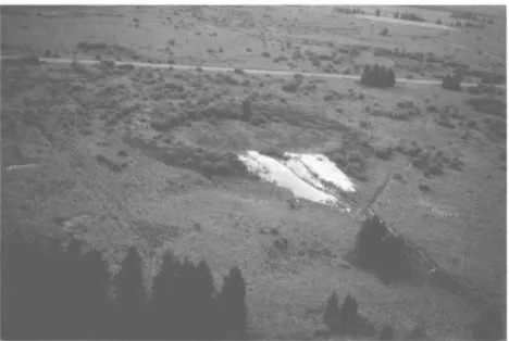
Figure 12. Aerial photograph, taken in July 1976, from the E to the W, of the vivier where cross-section 3, Figure 8, was observed.
Spoil earth appears light coloured because vegetation has not yet colonized it.
Figure 13. Cross-section 7 through rampart formed of piled solifluction bulges.
Cross-sections 8 and 9 were dug in ramparts whose formation is not well understood. The cross drawn on section 8 indicates the place where Laacher See tuff was observed and where organic matter was taken for 14C age
Figure 14. Present-day and remnants of lithalsas in northern Quebec.
The seven 14C age determinations performed on the peat layer which existed before the growth
of the Konnerzvenn mound, the age determination obtained from section 8 (Figure 13), and the revised age determinations obtained in three other sections thanks to volcanic dust, settled the disagreement in palynological interpretations.
The palynological study of the Konnerzvenn peat was published in 1986 (Damblon and Bastin), several years after the description of the cross-section by Pissart and Juvigne (1980), although Bastin had taken samples when the cross-section was cleared in 1978. The reason for this delay was that the new peat study was at variance with former palynological interpretations. B. Bastin's pollen diagram describes pollen found in 29 samples taken at every centimetre interval. The tephra level, visible to the naked eye and containing Laacher See dust, was 8 cm below the top.
The accumulation of peat was interrupted by the growth of the periglacial mound which happened during a colder episode. The improvement in temperature shown on the diagram corresponds to AllerOd, as proven by radiocarbon age determinations. This temperate period followed the colder period of the Middle Dryas and the Younger Dryas. The upper part of the diagram shows the beginning of the Younger Dryas fall in temperature, in perfect harmony with the hypothesis of periglacial growth of the mound during a cold period. Finally, a preliminary study of the Coleoptera found in the peat layer was performed by G. R. Coope (1985). This confirmed the author's observations in Allerod peats of other places.
The peat layer found in section 1 (Figure 8) is the oldest of the Hautes Fagnes Plateau. It made it possible to recount, now beyond dispute, the evolution of the vegetation during the period that preceded lithalsa formation. Although seven more digs were made later in the same sector (Figures 8 and 13), we have never found elsewhere such a peat layer; consequently this peat was extremely local. This conviction also leads one to use 'lithalsas' and not 'palsas' when referring to the mounds which existed during the Younger Dryas on the Hautes Fagnes Plateau.
CLIMATE CONDITIONS DURING THE YOUNGER DRYAS
It is clear that the observations, as a whole, establish that the lithalsas that produced the viviers had appeared during the Younger Dryas. At present the only explanation of the Younger Dryas fall in temperature is that warm water could not flow any more to the North Atlantic Ocean (Broecker, 1998; 1999). This hypothesis would explain why the observed climatic changes were very sudden (Severinghaus et al., 1998), essentially affecting the North Atlantic regions (Peteet, 1995) and modifying 14C abundance during the period.
TEMPERATURE CONDITIONS WHERE PRESENT-DAY
LITHALSAS EXIST
SUBARCTIC NORTHERN QUÉBEC/UNGAVA
The works of Lagarec (1976) prompted field investigations in northern Quebec in 1982 and 1983 with P. Gangloff (Pissart and Gangloff, 1984). The mounds that we examined are thought to be similar to the knolls that produced the Hautes Fagnes viviers. But they retain their ice and are still frozen. This is the reason why one does not see enclosed depressions with ramparts, that is, vivier-like forms. Later in 1998, on a field trip organized by Professor M. Allard after the Seventh International Conference on Permafrost, I observed not only present-day lithalsas (Figure 14) but also for the first time (on the Boniface River near Professor Serge Payette's camp) depressions that looked exactly like the Hautes Fagnes viviers (Figure 15).
It is interesting to know the present-day climatic conditions of areas where lithalsas are forming to define the conditions that prevailed on the Hautes Fagnes Plateau during the Younger Dryas. For example, the climatic conditions near the village of Kangiqsualujjuaq (58 °400 N, 65 ° 570 W;
see position on Figure 16) indicate, during the 1980 - 90 decade, that mean annual temperature varied between -4.4° and -6.7 °C, the average being -5; 8 °C (An and Allard, 1995). Mean January temperature was about -22 °C, mean July temperature +9.5 °C. Total annual precipitation reaches about 400 mm, including 42% snow. Wide areas, however, have no snow cover in winter, because it is blown away by the wind. Kangiqsualujjuaq is situated at the northern limit of the discontinuous permafrost zone.
Knowing the variability of temperature is also desirable. According to Allard et al. (1986), lithalsas are dispersed in the shrubby tundra to the north of the tree line, and thus in an environment where the mean temperature of the warmer month is more than 10 °C and the
mean annual temperature is less than -5 °C. Lithalsas also exist in glades of the forest tundra and in snow-free sites such as terraces without forest and low terraces near the coastline. The environment where lithalsas are observed is thus colder than the forested environment where most palsas are situated. Lithalsas depend on sediments in which segregation ice can easily appear; most are developed in marine silty layers. These same authors stress the important role of vegetation, which regulates the soil thermal balance by controlling snow distribution.
In the region, climatic observations are not numerous (Table 1). Inukjuak station is not situated in the palsa zone, but in the continuous permafrost zone. Kangiqsualujjuaq station is at the
northern border of the area where lithalsas are described, whereas Kuujjuaraapik is near its southern border. In the lithalsa region, further from the coastline temperature is not well known. All existing stations are situated near the sea shore, where the influence of Hudson Bay is obvious and important, as the distribution of vegetation associations on the east coast shows (Figure 16). Cold winds often blow eastward and reduce summer temperature. They give rise to nebulosity, to high frequency of fog and low clouds (Saint-Laurent and Filion, 1992).
To our knowledge, no papers mention lithalsas to the west of Hudson Bay, with the exception of the quite special lithalsas of Yukon, where a very light material replaces peat and has the same isolating effect as peat (Pissart et al., 1998). Probably lithalsas do not exist on this side of Hudson Bay, where sea influence is weak. The limit of continuous permafrost zone is at lower latitude while the tree line, because of a more continental climate, runs more to the north. Because lithalsas form in the discontinuous permafrost zone, but where the temperature of the warmest month is less than 10 °C, there appears little chance of finding such features in that
region.
NORTHERN SCANDINAVIA (LAPLAND)
While thousands of lithalsas have been observed in northern Quebec, the description of such features in Lapland remains rare. Lithalsas occur in the high regions near the point where the borders of Finland, Norway and Sweden converge. The authors who describe cryogenic mounds of this region call them either lithalsas or pingos (Lagerbach and Rodhe, 1985) or intermediate forms between pingos and lithalsas (Akerman and Malmströn, 1986).
Figure 15. Aerial and surface photographs of traces of lithalsas in northern Quebec (Canada), comparable with the Hautes Fagnes viviers.
The pictures were taken near the Boniface River, close to Professor Serge Payette's camp (57 °45’ N, 76 ° 15’ W).
It is hypothesized that these Lappish permafrost mounds with no peat cover are lithalsas. Ahman (1977) and Meier (1987) lay stress on a climatic change that could have occurred during the first century in the whole of Lapland. Ahman (1977) presented isotherm maps for long periods (1901 -31, 1931 -60 and 1960 - 74); temperatures were about 1 °C higher in 1931 -60 in
the region.
The few available data indicate (Table 2) that mean annual temperatures are -3 °C to -4.5 °C and the mean temperatures of the warmer month are less than 9 °C. All four sites belong to the
conditions are not so different from the conditions encountered in northern Quebec where, however, winters are colder.
Figure 16. Distribution of vegetal associations in northern Québec, according to Lavoie and Payette (1994), and zones of palsas and lithalsas (personnal communication, D. Lagarec, University of Ottawa, 1986).
The meteorological stations mentioned in his letter are indicated on the map, as well as the site near the Boniface River where the lithalsa traces of Figure 14 were observed.
Table 1. Temperature in lithalsa zone of northern Quebec and in bordering regions without lithalsas (°C).
Site Mean temperature
of warmest month
Mean temperature of year
Mean temperature of coldest month Inukjuak (Allard and Seguin, 1987)
(outside lithalsa zone, in continuous permafrost area)
+8.5 -6.7 -25.2
Kangiqsualujjuaq (An and Allard, 1995) +9.5 -5.8 -22.0
Kuujjuaq (Worsley et al., 1995) +11.5 -6.0 -24.0
Poste de la Baleine, Kuujjuaraapk (Allard and Seguin, 1987)
+10.7 -4.3 -23.0
Schefferville (Payette and Filion, 1993) (outside lithalsa zone)
Table 2. Temperature in Lappish regions where cryogenic mounds are likely to be lithalsas (°C).
Site Mean temperature
of warmest month Mean temperature of year Mean temperature of coldest month Corgossjokka, Norway, 70°00’ N, 26°00’ E,
altitude 580 m (Meier, 1987) (no precise temperature data available, only extreme data) +9 to +12 -1 to -3 -13 to -17 Taavavuoma, Sweden, 68°30’ N, 20°45’ E, altitude 600 m (Wramner, 1973) -3 to -4 Sweden, 69°00’ N, 21 °300 E, altitude 700 -
800 m (Lagerbach and Rodhe, 1985)
-3.5 (1951-80)
Rakaslako, Sweden, 68°25' N, 18°30' E, altitude 850-1000 m (Akerman and Malmström, 1986)
850 m +8.3 -3.9 -14.6
950 m +7.2 -4.4 -15.1
CONDITIONS OF APPEARANCE AND LIKELY WORLD DISTRIBUTION OF
LITHALSAS
The climatic data from northern Quebec and also from Lapland lead to another interesting conclusion. They reveal how narrow are the climatic conditions that favour the formation of lithalsas; this could explain why actively growing lithalsas have rarely been observed elsewhere in the world.
Lithalsas occur in regions where the temperature of the warmest month is less than or near +10
°C (tree line) and where permafrost is discontinuous. If these criteria are accepted, such regions
can be identified on the map of northern hemisphere permafrost (Brown et al., 1997) which shows also the northern tree line (10 °C isotherm of warmest month). In North America the tree
line adjoins the discontinuous permafrost limit in northern Quebec, to the north of Great Slave Lake and at the western end of Alaska. Tree line and discontinuous permafrost limit are also next to each other in Lapland and, on both sides of the Ural Mountains, in Russia. Beyond the Ienissei River, in Siberia, the tree line is within the continuous permafrost zone and, therefore, lithalsas cannot form. However, they could appear in the Kamtchatka Peninsula and in a narrow Siberian coastal fringe near the Sea of Okhotsk.
RECONSTRUCTING THE YOUNGER DRYAS TEMPERATURE
IN HAUTES FAGNES
Of great relevance to this paper is the content of an Amsterdam University thesis, presented in November 1997 by Rene Isarin; its title is 'The climate in north-western Europe during the Younger Dryas. A comparison of multi-proxy climate reconstructions with simulation experiments' (Isarin, 1997a). This work is the best reconstruction of the conditions that prevailed in Belgium during that period.
Table 2 Temperature in Lappish regions where cryogenic mounds are likely to be lithalsas (°C).
The Younger Dryas is the cold period for which a climatic reconstruction is the easiest since it is the latest cold period (beginning about 13,000 years bp: Isarin, 1997a). Several authors mentioned by Isarin (1997a; 1997b) think that the Younger Dryas has to be divided into two stages. The first stage was supposedly colder and was followed, about 10,500 14C years bp, by a
somewhat milder climate.
According to Iversen (1944), there is a relationship between distribution of plants and temperature; this helps to infer past temperatures. During growth, trees and other plants need a specific minimum summer temperature to bloom and breed. The tree line approximates the +10
°C isotherm of the warmest month. Severity of winter frost has no determining influence on this
limit: Oimiakon, Siberia, the cold pole of the northern hemisphere, is situated in the boreal forest. The extreme continental climate of this place is responsible for its very cold winters, but also for its very warm summers.
Isarin (1997a; Isarin and Bohncke, 1999) gathered together 140 pollen diagrams and macrofossil observations from the whole of western Europe. The author supplies a list of28 species with their corresponding July minimum temperature. The isotherms drawn on Figure 17 have been reduced to sea level according to a standard lapse rate of 0.6 °C per 100 m. It must be
Figure 17.
(a) Probable distribution of average minimum temperature at sea level in July during the first part of the Younger Dryas (Isarin, 1997a, p. 69). (b) Probable distribution of average minimum temperature at sea level in July during the second part of the Younger Dryas. (Isarin, 1997a, p. 72). From: Isarin RFB, Bohncke SJP. 1999. Quaternary Research. Reproduced by permission of Academic Press.
Mean annual temperatures have been deduced by quite different observations (Isarin, 1997a; 1997b). Isarin considers three phenomena: ice wedges filled with ice, cryogenic mounds and cryoturbations. While ice wedges and cryogenic mounds are appropriate, one must be more
sceptical about using cryoturbations. Isarin used 87 locations where he believes the periglacial phenomena are reliably dated to the Younger Dryas. Among those sites are the viviers of the Hautes Fagnes Plateau, which are thought to be traces of mineral palsas (lithalsas). He believes those features are characteristic of discontinuous permafrost and he indicates that a mean annual air temperature equal or less than -4 °C is necessary for the appearance of these mounds. Isarin's maps are reproduced in Figure 18. The first (a) displays the distribution of the continuous and discontinuous permafrost in western Europe during the Younger Dryas. The second (b) is an interpretation of the mean annual temperatures at sea level. Temperatures in italic are the temperatures of the coldest month, assuming the graph of the monthly figures is a sine curve that equally overlaps the mean annual temperature. In other words, it assumes that the deviation between the temperature of the coldest month and the mean annual temperature is equal to the deviation between the temperature of the warmest month and the mean annual temperature. This is a condition which is fulfilled at the present time.
Thanks to these maps it can be concluded that, on the Hautes Fagnes Plateau, the mean annual temperature during the first part of the Younger Dryas was about -5.0° to -6.2 °C, taking into account an altitude between 500 and 700 m and a temperature gradient of 0.6 °C per 100 m. The
mean temperature of the warmest month was about +9.3° to +10.5 °C, the mean temperature of
the coldest month -20.5 ° to -21.7 °C. These values can be compared with those of northern Quebec where numerous lithalsas occur at present. The typical temperatures are very close to the temperatures of the Hautes Fagnes Plateau, between 500 m and 700 m altitude, during the Younger Dryas, as found by Isarin: mean annual temperature from -5.8° to -4.3 °C in northern Quebec, -5.0° to -6.2 °C in Hautes Fagnes; mean temperature of the warmest month from +9.5°
to +10.7 °C in northern Quebec, +9.3° to +10.5 °C in Hautes Fagnes; mean temperature of the
coldest month from -22.0° to -24.0 °C in northern Quebec, -20.5° to -21.7 °C in Hautes Fagnes. All these data reinforce the opinion that Isarin (1997a; 1997b) has correctly defined the temperature conditions that prevailed on the high plateau during the Younger Dryas. In summary, one can conclude that, during the Younger Dryas, the top of the Hautes Fagnes Plateau experienced a January mean temperature about 20 °C lower than nowadays; the mean annual
temperature was 12 °C lower and the mean temperature of July was only 5 °C lower (Figure 19).
From 1960 to 1990, at Baraque Michel (Hautes Fagnes), the mean temperatures were, according to M. Vandiepenbeek (IRM): January -1.7 °C, year +6.2 °C, July +14.0 °C.
LITHALSA REMNANTS ELSEWHERE IN THE WORLD
I tried for many years to demonstrate that explaining the viviers as remnants of pingos was wrong and that they should be considered as traces of lithalsas (mineral palsas), but I did not convince everybody. Gurney (1995) and Worsley et al. (1995) are the only ones who agree, in relation to the Welsh features. Consequently, if remnants of lithalsas exist elsewhere, they are usually considered as remnants of pingos.
The important literature describing pingo remnants show very few morphologies similar to the viviers. To accept a similarity with the remnants of lithalsas the depressions must be (1) ramparted, (2) very numerous and in clusters and (3) dated from the Younger Dryas.
Considering these conditions, features identical with the Hautes Fagnes viviers have been observed in southern Ireland (Mitchell, 1971; 1973; Coxon, 1986; Coxon and O'Callaghan, 1987; Warren, 1987; Bryant and Carpenter, 1987) at altitudes between 20 and 150 m; in Wales between 200 and 330 m (Pissart, 1963; E. Watson, 1971; 1972; 1977; E. and S. Watson, 1972; 1974); and in the Hautes Fagnes between 500 and 700 m.
The study of lithalsas in northern Quebec shows that these features exist where the average annual temperature is between -4.3 ° and -6 °C (in Table 1, the -4 ° and -6.7 °C data come from lithalsa-free areas) and the mean temperature of the warmest month is between +9.5 ° and
+11.5 °C. Unfortunately such precise data are not available from Lapland; there, lithalsas seem to
exist if the average annual temperature is -3.9 °C and the mean temperature of the warmest month 8.3°C (Table 2).
In summary, lithalsas appear in areas where the average annual temperature is -4 ° to -6 °C and the mean temperature of the warmest month is between +8.3 ° and +11.5 °C. Figures 20, 21 and
22 show where, according to Isarin, such areas exist at sea level, at an altitude of 250 m and at an altitude of 500 m, altitudes at which lithalsa remnants are observed respectively in Ireland, in Wales and in the Hautes Fagnes.
On Figure 20, there is only a small area in Ireland at sea level where lithalsas could form. Taking into account the environmental temperature lapse (0.6°C per 100 m) used by Isarin, the lithalsa
traces found between 20 mand 150 m of altitude, at lower latitudes more to the south, are quite plausible, under the same temperature conditions.
At an altitude of 250 m (Figure 21), according to the same temperature gradient, the area where lithalsas could appear spreads out over the southern part of Ireland and Wales, where lithalsa remnants have already been observed. On the European continent, this zone is extended to the Dutch and German plains, but lithalsas could not form there because nowhere does the altitude reach 250 m.
Figure 18.
(a) Distribution of the continuous and discontinuous permafrost in western Europe during the Younger Dryas (Isarin, 1997a, p. 54). (b) Isotherms of the mean annual temperature and—by dead reckoning—mean temperature of the coldest month (in italic), at sea level, during the Younger Dryas. (Isarin, 1997a, p. 56) From: Isarin R. 1997. Permafrost distribution and temperatures in Europe during the Younger Dryas. Permafrost and Periglacial Processes 8(3): 313-333. © John Wiley & Sons Limited. Reproduced with permission.
Figure 19. Comparison between present-day temperatures at Baraque Michel (Hautes Fagnes) and estimated temperatures during the Younger Dryas.
Because the curves are sinusoids, the mean temperature of the coldest month can be inferred from the mean annual temperature and the mean temperature of the warmest month. Present-day temperatures are given by IRM for the 1960 - 90 period.
Figure 20. Map drawn after the palaeogeographical reconstruction of Isarin (1997a) for the first part of the Younger Dryas.
It shows areas where, at sea level, the average annual temperature (TMA) was between -3.9° and -5.8 ° C and the mean July temperature (TMJ) was between +9° and +11.5 °C. Where the hachures overlap each other, it is the zone where, at sea level, climatic conditions were propitious to the appearance of lithalsas. According to this figure, there were favourable conditions, at sea level, only in Ireland.
Figure 21. Map drawn after the palaeogeographical reconstruction of Isarin (1997a) for the first part of the Younger Dryas.
It shows the areas where, at an altitude of 250 m, the average annual temperature (TMA) was between -3.9° and -5.8 °C and the mean July temperature (TMJ) was +9° and +11.5 °C (temperature lapse rate used: 0.6 °C per 100 m). Where the hachures overlap each other, it is the zone where, at an altitude of 250 m, climatic conditions were propitious to the appearance of lithalsas. On the continent, in the Dutch and German plains, lithalsas could not form because nowhere is the altitude of 250 m reached.
At 500 m altitude (Figure 22)—the minimum altitude at which many viviers are found in the Hautes Fagnes — the area where lithalsas could form during the Younger Dryas extends from the south of England to beyond Frankfurt in Germany. However there is some discordance with the region where lithalsa traces have been actually observed: no forms identical with the viviers have been found in the massifs to the east of the Ardennes that are in excess of 500 m ASL. In order to get a coincidence of the observations with Isarin's data, it is sufficient merely to adjust the mean temperature of the warmest month by 1 °C; in this way, the zone is deprived of its
eastern part and is perfectly restricted to the area where remnants of lithalsas have been discovered in Belgium.
Similar but older remnants of lithalsas exist in Norfolk (Sparks et al., 1972) and probably in the Netherlands (Kasse and Bohncke, 1992). They might have appeared during a climatic episode comparable with the Younger Dryas, but colder. If the average annual temperature had been the same, the mean temperature of the warmest month would have been 2.5 °C less than in the
Younger Dryas.
Other remnants of lithalsas were also described in Lapland but here they are Holocene in age (Svensson, 1964; 1969; Seppälä, 1972). Both of these authors underline the similarity with the viviers des Hautes Fagnes. They are not far from the location of present-day lithalsas and show that a colder climate existed in the Holocene.
Figure 22. Map drawn after the palaeogeographical reconstruction of Isarin (1997a) for the first part of the Younger Dryas.
It shows the areas where, at an altitude of 500 m, the average annual temperature (TMA) was between -3.9° and -5.8 °C and the mean July temperature (TMJ) was between +9° and +11.5 °C (temperature lapse rate used: 0.6 °C per 100 m). Where both hachures overlap each other, it is the zone where, at an altitude of 500 m, climatic conditions were propitious to the appearance of lithalsas. This schema applies perfectly to the lithalsa remnants on the Hautes Fagnes Plateau. Nevertheless, the favourable zone extends through Germany on to the Czech Republic, in regions where no lithalsa traces are known. The dashed line is the July +10.5 °C isotherm. If this line is adopted as the limit of the favourable zone, it explains the existence of lithalsa remnants in the north of the Belgian Ardennes but not to the east of Belgium.
CONCLUSIONS
A world-wide survey of the forms described as remnants of cryogenic mounds shows that, even if numerous closed depressions have been interpreted as traces of pingos, few have morphologies similar to the Hautes Fagnes viviers and few can be considered as lithalsa scars. The viviers of the Hautes Fagnes are rare features that have, to date, equivalents known only in the British Isles and Lapland.
All the forms interpreted as traces of cryogenic mounds have, until now, been described in a confused medley from which no palaeogeographical conclusions were possible. Lithalsa and pingo remnants were indeed mistaken. It is however possible to delimit, with the help of the palaeoclimatic reconstruction of Isarin (1997a), the areas where, during the Younger Dryas, lithalsas could form. The present attempt of reconstruction reveals that remnants of lithalsas are precise palaeoclimatic indicators but, alas, there are very few of them.
My first publications on the subject contributed to the regrettable confusion between pingo traces and lithalsa traces. The reason for the mistake is that, before the early 1970s, lithalsas were unknown. However, I am careful not to believe that everything about the viviers is found and known. There is still much more to study about the present lithalsas.
ACKNOWLEDGEMENTS
I am grateful to my friends Jean Grimberieux, for translating the text from French to English, and Professor Hugh French, Editor-in-Chief, for improving the manuscript and smoothing the English.