Quantifying flood damages for climate-change adaptation on a
transnational river basin
Case study from the AMICE project on the Meuse basin
Maïté FOURNIER, Benjamin SINABA, Benjamin DEWALS, Gilles DROGUE
Abstract
The Meuse river basin is shared by five countries. Climate change in the future decades could either lead to a dryer or a wetter situation. In order to build an adaptation strategy that would cope with both scenarios and that is agreed at the international level, water experts have set-up the AMICE project. Quantifying the flood damages is an important part of this project. It required much negotiation at every intermediary step, from the definition of climate scenarios, to the hydraulic modeling and the agreement on damage functions.
1 The challenges of transnational cooperation and climate change
When one deals with climate change impacts or wants to elaborate an adaptation strat-egy, the first questions are: what are the impacts and how much would these cost? Miti-gation mechanisms or adaptation measures are only accepted if they cost less than the expected damages. Damage quantification is thus an essential step.
Floods are a common phenomenon which is expected to increase in the future years due to climate change (EEA, 2007).
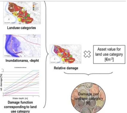
Calculating flood damages requires four input parameters (Sinaba et al., 2012), (see Fig.1):
• the inundation depth and extent, resulting from inundation modeling ; • the land-use in the flooded area ;
• the damage function for each land-use category, which represents the susceptibility of the assets to inundation depth ;
• the asset value in each land-use category.
The theory looks quite simple but it can get quite difficult when dealing with: • a transnational river basin,
Figure 1: Combination of input parameters in AMICE flood assessment methodology.
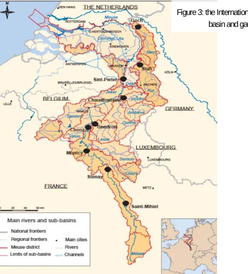
The Meuse river basin is located in North-West Europe (see Fig.3). The basin is shared between France (most upstream part), Luxembourg, Belgium (Wallonia and Flanders), Germany and the Netherlands (where the Meuse flows into the North Sea). Three differ-ent languages are spoken on the Meuse territory. The catchmdiffer-ent area is nearly 9,000 km² and we can reasonably assume that climate change impacts will be comparable (Drogue et al., 2010). Within the International Meuse Commission, the idea came to build a common adaptation strategy and to share forces. However, each country had built its own national land-use datasets, damage functions, and methodologies to model floods. These are so different that the figures produced by each country cannot be compared as it. Common or harmonized tools and references are needed as a first step.
Climate change is already taking place. But high uncertainties remain on the climate evolutions trends for the future decades. Depending on the global circulation models chosen, North-West Europe would either become drier or wetter (EEA, 2007). Water managers need better trends, especially when building water infrastructures designed to last for over 50 years.
The AMICE Project was created to respond to these challenges.
2 The AMICE Project
AMICE stands for Adaptation of the Meuse to the Impacts of Climate Evolutions. It involves 17 Partners: water managers, researchers, public authorities and associations. The Partners have been working together since 2009.
The Project has a total budget of 8.9 million € and is funded through the European Pro-gramme Interreg IV B (2.8 million €) as well as governments of the Meuse basin’s countries.
The goals are to:
• propose an adaptation strategy, to deal with the future floods and low-flows, for the Meuse basin
• implement measures that are good examples of adaptation • strengthen the international partnership of water experts
that is initiated by the International Meuse Commission • communicate our results to other river basin managers,
to the decision makers of the Meuse basin and to its in-habitants
There are five workpackages, each representing one way of adapting to climate change: • sharing knowledge to understand and quantify the impacts of climate change
• make use of the nature’s resilience to climate evolutions
• improve the water infrastructures to deal with both higher or lower discharges • prepare for extreme events
• communicate and raise awareness of the threats and solutions
The present results are achievements of the Workpackage 1. The scientific lead is pass-ing from one university or research institute to another, accordpass-ing to their field of exper-tise. Credits should be given to the University of Lorraine (climate and rainfall-runoff modeling), the University of Liège (hydraulic modeling) and the Institute of Aachen (impact assessment), as well as all AMICE Partners contributing outputs for their terri-tories.
3 From climate scenarios to damage quantification
3.1 The AMICE climate scenarios
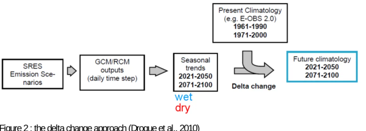
Many climate change studies are available that provide insights for the end of the cen-tury (ENSEMBLES, 2009). However decision makers also need information on the short and medium terms. The AMICE Partners settled on two future periods: 2021-2050 and 2071-2100, each lasting 30 years which is most common in hydrology studies. The climate of these two periods will be compared to the years 1971-2000, called the refer-ence period.
1,00 33 000 Transnational 0,10 3 338 Germany 0,26 8 662 Netherlands 0,33 10 880 Belgium 0,31 10 120 France Weight Catchment area (km²) 1,00 33 000 Transnational 0,10 3 338 Germany 0,26 8 662 Netherlands 0,33 10 880 Belgium 0,31 10 120 France Weight Catchment area (km²)
For our purposes, temperature and precipitations will be used. Evapotranspiration can be determined with the method of Oudin (2005). Annual means cannot be used in hydrol-ogy which is influenced by inter seasonal variability. Seasonal trends (in % for precipi-tations, in °C for temperatures) are easy access and have been used within AMICE. Monthly or even daily information would have been even better but these were not yet validated when AMICE work started. The delta change approach has been used, which modifies the climate input parameters on the reference period by the seasonal perturba-tion factor (see Fig.2).
Figure 2 : the delta change approach (Drogue et al., 2010)
It soon turned out that there were no existing climate scenarios downscaled on the inter-national Meuse basin. Each country had used its own assumptions and methods to pro-duce scenarios for its national territory (The Netherlands and Flanders: PRUDENCE, 2006 – Germany: WETTREG, CLM, 2009 – Belgium: CCI-HYDR, 2008 – France: ARPEGE Climat, 2007). A transnational scenario was needed.
All global circulation models agree that temperature will increase in Europe in the com-ing decades. Rainfalls are either expected to increase or to decrease in the Meuse area, depending on the models (EEA, 2007). To take into account this uncertainty, we de-cided to work both on a “wet” and a “dry” scenario. In between these two scenarios lies the wide range of possible futures.
Each country involved in AMICE contributed the seasonal trends of precipitations and temperatures for the periods 2021-2050 and 2071-2100, and representing a wet and a dry climate. The figures from each country were weighted according to their drainage area within the Meuse basin. This quick solution ensures that all countries’ scenarios are taken into account (see Table 1).
Table 1: Determination of the weighting factor for each Meuse country (Drogue et al. 2010)
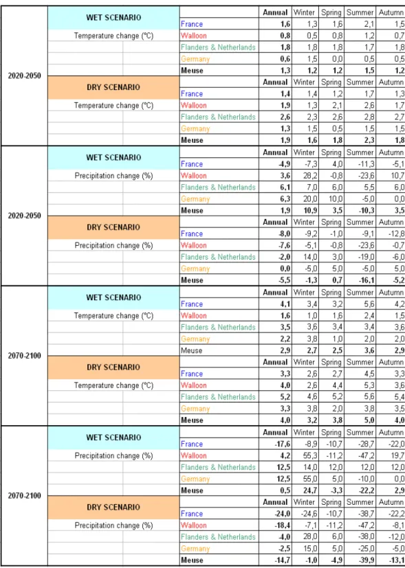
Table 11. Seasonal trends in precipitation (%) and air temperature (°C) for the na-tional sub-basins and for the transnana-tional scenario for the two time slices (2021-2050 & 2071 2100) Dry & wet scenarios
Under the wet scenario, temperatures are expected to increase by 1.3 °C to 2.9 °C with little difference in between the seasons. Precipitations are expected to increase in winter (+10.9% in 2021-2050 and +24.7% in 2071-2100). Even under the wet scenario, pre-cipitations are expected to decrease in summer (see Table 2)!
Table 2: Seasonal trends in precipitation (%) and air temperature (°C) for the national sub-basins and for the trans-national scenario for the two time slices (2021-2050 & 2071-2100), (Drogue et al., 2010)
Figure 3: the International Meuse river basin and gauging stations used
3.2 Rainfall-runoff modeling on the Meuse basin
What would be the consequence of such scenarios in terms of river discharges?
Once more, each country uses its own rainfall-runoff modeling and none is available that covers the whole Meuse basin with sufficient details (The Netherlands: HBV – Germany: NASIM - Flanders: TOPMODEL, MIKE 11 - Wallonia: PDM - France: AGYR). All models have been used and their results compared to check if discharges modifications are of the same range.
For floods, the Partners agreed to compare their models’ outputs on the hourly peak discharge of a 100 years return period flood (Qhx100). Nine gauging stations have been used (see Fig.2), four of them are on major tributaries: the Lesse and the Vesdre (Bel-gium), the Rur and the Niers (Germany).
On the Meuse river, models yielded comparable results. The Qhx100 would increase by 15% in 2021-2050 and by 30% in 2071-2100 under the wet scenario. No modification with the reference period appears under the dry scenario (Drogue et al., 2010).
Climate change studies also point out that flash floods are bound to increase in the fu-ture and that floods would not only become bigger but also more frequent (EEA, 2007). These were not included in AMICE for lack of statistics and because seasonal trends do not provide enough information on these phenomenon’s.
3.3 Hydraulic modeling from spring to mouth
Four different hydraulic models exist on the Meuse River and an additional one is avail-able on the Rur tributary. These models cover the full length of the river course, from its spring in France to its mouth in the Netherlands (see Fig.4). Nonetheless, these models have different characteristics, so that connecting them is not straightforward. Building a new transnational hydraulic model is also out of the scope of the project and would be of little added-value except nearby the borders.
Figure 4: River stretches covered by existing hydraulic models (Detrembleur et al., 2012)
A solution has therefore been developed to harmonize the input/output data at the boundaries between the existing models.
The hydraulic modeling has been conducted in three steps (Detrembleur et al., 2012). • Each model has first been run independently, inflow discharges and downstream
water depth being deduced from observed time series.
• Next, water depths computed by each model have been compared at the boundaries between models. This required a common geographical reference system
(Longi-tude/Latitude and Belgian DNG/TAW). When discrepancies were detected, they have been analysed and corrected.
• Finally, a second run of the models has been performed, using boundary conditions provided by the upstream and downstream models.
This procedure has enabled to achieve the first harmonized simulation of inundation flows along the whole course of river Meuse, even across the borders.
Climate change is likely to worsen the severity of future floods. Compared to levels of the present 100-year flood, the expected increases in flood levels would reach, respec-tively for 2021-2050 and 2071-2100,
• between 30 cm and 70 cm in the southern and northern part of the basin, where floodplains are particularly wide,
• between 60 cm and 130 cm in the central part of the basin, between Sedan and Mon-sin, where the valley is more narrow (Ardennes massif).
The changes in inundation extents and volumes stored in the floodplains have also been analyzed.
3.4 Damage calculation methodologies
AMICE damage calculation is limited to direct tangible economic flood losses, at the scale of the international basin.
3.4.1 Inundation depth
The inundation depths and extents of a future flood have been determined by the model-ing described above. One of the parameters required for flood damage calculation is ready and coherent at the international level.
3.4.2 Land-use categories
There are numerous databases available on the Meuse river basin but none covers the whole basin, except the European Corine Land Cover (CLC) database. Its resolution is quite large (1:100000). As a consequence, the figures from the AMICE damage calcula-tion will be quite coarse compared to regional assessments. Since our goal is to evaluate the extra damage related to climate change, not the exact damage of one flood, the CLC database is deemed sufficient (Sinaba et al., 2012).
The subcategories of CLC were not used, as it appeared difficult to find damage func-tions for each one of them. The 6 categories used are Settlement, Industry, Traffic, Agri-culture, Forests and Others. The Traffic category is badly represented in CLC because of the coarse resolution. To solve this, we assumed that 5% of the mobile assets under the category Settlement are in fact cars and should be counted under Traffic. In the same
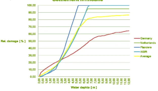
Figure 5: Comparison of relative damage functions used in the Meuse countries for the category Settlement immobile (from AMICE – WP1 meeting – April 6th, 2011 – Aachen)
way, 10% of the immobile assets under the category Settlement are in fact roads and parking and should be counted under Traffic.
Land-uses will change between the reference period (1971-2000) and the future ones (2021-2050 and 2071-2100) as a result of human development, but there is too little information about these changes. Furthermore, AMICE would have needed data with enough details to identify changes taking place within the flood-prone area. Within AMICE, we assume that no modification will occur to the land-use of the Meuse basin.
3.4.3 Asset values
Asset values are the only parameter where no homogeneity is required and national official statistics can be used. The asset values of neighbour territories are indeed very different depending on the wealth and density of communities. All Partners agreed to use the year 2009 as the price reference.
The national asset values, which have been defined on the bases of national land-use databases, have to be aggregated to match the CLC categories within the floodplains (Sinaba et al., 2012).
3.4.4 Damage functions
Damage functions represent how each asset is impacted by water depth. The AMICE Partners explored literature to identify damage functions corresponding to our 6 CLC categories.
0,00 10,00 20,00 30,00 40,00 50,00 60,00 70,00 80,00 90,00 100,00 0 1 2 3 4 5 6 7 8 water depth [m] Re l. d am ag e [ % ] Settlement immobile Settlement mobile Industry immobile Industry mobile Traffic immobile Traffic mobile Forestry Agriculture
• empirical derivation by means of real flood data and damage surveyed after flood events ;
• synthetic data estimated from standardized property types ;
and can result from the combination of functions from subcategories. Universality and transferability of these functions is often criticised.
When we compared the damage functions found in each country for the same category, we came up with huge differences that could not always be explained (see Fig.5). The Partners negotiated each damage function, for mobile and immobile asset values (see
Fig.6).
Figure 6: Relative damage functions for the 6 CLC categories and for mobile or immobile assets, as used in the AMICE approach (Sinaba et al., 2012)
3.4.5 Partially common approach versus AMICE approach
The AMICE approach uses the transnational climate scenarios and hydraulic results, the CLC database and the common damage functions.
Since damage functions can vary greatly, we decided to carry a sensitivity analysis on some of the Meuse territories and to use regional damage functions.
In Fig.7, it appears that the damage function used has a much greater impact on the damage costs than the scale of the land-use database. It also seems that the AMICE approach would underestimate losses.
The sensitivity analysis still has to be performed on other territories and conclusions may evolve. On the Rur, a calculation was also undertaken with a finer land-use data-base (Sinaba et al. 2012).
4 Forthcoming steps
Flood damage calculation will be used to point-out:
• which land-use category is most affected by higher floods related to climate change; • which territories are most affected by higher floods related to climate change.
These two elements will help us identify where to act in priority and which actions have to be taken. The results will be included in the Meuse adaptation strategy.
Partners are also discussing how to display these results so the decision makers under-stand them easily and can take the right decisions. The scale used to draw these maps is of high importance. A high resolution could spark opposition from the local population and lead to downright refusal because of the high uncertainty related to climate change and modeling. The AMICE results for the wet scenario represent only one of the many possible futures. A low resolution would focus attention on the Meuse river and major cities, disregarding the tributaries and smaller communities where action should none-theless be taken.
A parallel study is also undertaken on the topic of low-flows, which are quite a new threat for the Meuse. The damage calculation approach is completely different from the flood losses calculation, as impacts vary with the water uses. The focus is put on agri-culture, energy production and inland navigation. Drinking water seems less directly Figure 7: Flood damages (in million Euros) for each category and for three approaches on the Rur basin.
The river discharge would lead to a 100 years return period flood on the Meuse (reference pe-riod 1971-2000)
affected by a low-flow situation as other water sources can be temporarily used such as water reservoirs or groundwater.
5 Conclusion
Transnational cooperation brings many benefits to the involved Partners. Models have been improved and updated. A method now exists for data to be exchanged between the national models. New methodologies and data become accessible. Comparisons with the neighbour countries help criticize your own results and quickly understand inaccuracies. There is still a lot that can be done on the Meuse basin: apply climate change scenarios to more tributaries, take into account future land-use evolutions, study the impacts not only on the economy but also on the environment and social organisations, etc. How-ever, AMICE already achieved to build the partnership of water experts that are willing to continue cooperation and to set common methodologies and processes for the whole Meuse basin.
6 References
Detrembleur et al. (2012), yet unpublished: Effect of climate change on river Meuse, Hydraulic modelling from spring to mouth. AMICE – WP1 – Action 6 – technical report Drogue et al. (2010) Analysis of climate change, high-flows and low-flows scenarios on the Meuse basin. AMICE - WP1 – Action 3 – technical report.
European Environment Agency (2007): Climate change and water adaptation issues. EEA Technical Report No 2/2007. Copenhagen - ISBN 978-92-9167-917-1
Sinaba et al. (2012), yet unpublished: Quantification of the impacts of future floods on the economy in the international Meuse basin. AMICE – WP1 – Action 7 – technical report
Van der Linden P., and J.F.B. Mitchell (eds.) (2009): ENSEMBLES: Climate Change and its Impacts: Summary of research and results from the ENSEMBLES project. Met Office Hadley Centre.
Author
M. Fournier
EPAMA (Etablissement Public d’Aménagement de la Meuse et ses Affluents) 26, avenue Jean Jaurès
08 000 Charleville-Mézières FRANCE