UNIVERSITY OF LIEGE FACULTY OF APPLIED SCIENCES
UEE RESEARCH UNIT HECE RESEARCH GROUP
Advanced porosity-based models
to assess the influence of urban layouts on inundation flows
and impact of urban evolution on flood damage
by
BRUWIER Martin
Thesis submitted in partial fulfilment of the requirements for the degree of Doctor of Philosophy in Applied Sciences
Jury
DEWALS Benjamin (Advisor) Pr. Dr. Ir., University of Liège ARCHAMBEAU Pierre (Co-advisor) Dr. Ir., University of Liège DIMITRIADIS Greg (President) Pr. Dr. Ir., University of Liège
TELLER Jacques Pr. Dr. Ir., University of Liège
MIGNOT Emmanuel Dr. Ir., INSA (Lyon), LMFA Laboratory
VAZQUEZ José Pr. Dr. Ir., ENGEES (Strasbourg), Icube
Laboratory
i
A
CKNOWLEDGMENT
This PhD thesis was funded through the ARC grant, financed by the Wallonia-Brussels Federation. I am also grateful to the University of Liège for providing the resources necessary to conduct this research.
I thank the President of the Jury committee Greg Dimitriadis and the members of the committee Jacques Teller, Emmanuel Mignot and José Vazquez for accepting to review my work. I hope they will appreciate the reading of this manuscript.
I want to thank Ahmed Mustafa for our exciting exchanges regarding the interactions between urbanization and floods.
Merci à Michel Pirotton et Sébastien Erpicum pour leur accueil au sein du service HECE. Je remercie Pierre Archambeau, co-promoteur de ma thèse, pour ses excellents conseils, son enthousiasme et sa patience, particulièrement pour la partie numérique de ce travail.
Merci à mon promoteur, Benjamin Dewals, de m’avoir offert la possibilité de découvrir le monde de la recherche. Merci également pour le temps considérable que vous m’avez consacré tout au long de ces quatre années de thèse, pour la qualité et la pertinence de vos remarques et suggestions ainsi que pour l’enthousiasme et la rigueur scientifique que vous m’avez inculqués.
Merci également à Laurence pour son aide technique et aux autres membres de l’équipe HECE avec qui j’ai partagé de bons moments aux pauses cafés, temps de midi ou after-works: Maurine, Yan, Velya, Benjamin, Mohammad et Diana. Un remerciement particulier à Fred pour l’aide que tu m’as apportée en début de thèse. Je suis content d’avoir eu la chance de faire ta connaissance. Merci à Louis pour ta disponibilité, tes connaissances en informatique et, surtout, de m’avoir supporté quatre années dans notre bureau. J’ai commencé ma thèse avec un pote et je la termine avec un ami. En parlant d’amitié, merci à Ismaïl pour les bons moments passés à l’Université de Liège et en dehors.
Enfin, je remercie ma famille et mes amis pour leurs soutiens tout au long de ma thèse. En particulier, merci à mes parents pour leur présence et leur affection.
iii
K
NOWLEDGE DISSEMINATION
Articles in peer-reviewed academic journals
As a first author
1. Bruwier, M., Archambeau, P., Erpicum, S., Pirotton, M., & Dewals, B. (2017). Shallow-water models with anisotropic porosity and merging for flood modelling on Cartesian grids. Journal of Hydrology, accepted.
http://hdl.handle.net/2268/214640
2. Bruwier, M., Erpicum, S., Pirotton, M., Archambeau, P., & Dewals, B. (2015). Assessing the operation rules of a reservoir system based on a detailed modelling chain. Natural Hazards & Earth System Sciences, 15, 365-379.
http://hdl.handle.net/2268/171905
3. Bruwier, M., Archambeau, P., Erpicum, S., Pirotton, M., & Dewals, B. (2016). Discretization of the divergence formulation of the bed slope term in the shallow-water equations and consequences in terms of energy balance. Applied Mathematical Modelling, 40(17-18), 7532–7544.
http://hdl.handle.net/2268/192948
4. Bruwier, M., Erpicum, S., Archambeau, P., Pirotton, M., & Dewals, B. (in press). Computing flooding of crossroads with obstacles using a 2D numerical model (Discussion). Journal of Hydraulic Research.
http://hdl.handle.net/2268/209999
As a co-author
5. Dewals, B., Bruwier, M., Erpicum, S., Pirotton, M., & Archambeau, P. (2016). Energy conservation properties of Ritter solution for idealized dam break flow. Journal of Hydraulic Research, 54(5), 581-585.
http://hdl.handle.net/2268/195262
6. Arrault, Finaud-Guyot, P., Archambeau, P., Bruwier, M., Erpicum, S., Pirotton, M., & Dewals, B. (2016). Hydrodynamics of long-duration urban floods: experiments and numerical modelling. Natural Hazards & Earth System Sciences, 16, 1413-1429.
7. Saadi, I., Bruwier, M., El Saeid Mustafa, A. M., Peltier, Y., Archambeau, P., Erpicum, S., Orban, P., Dassargues, A., Dewals, B., Pirotton, M., Teller, J., & Cools, M. (in press). Development trajectory of an integrated framework for the mitigation of future flood risk: results from the FloodLand project. Transportation Letters: The International Journal of Transportation Research.
http://hdl.handle.net/2268/208789
Scientific congresses and symposia
As a first author
8. Bruwier, M., Dewals, B., Erpicum, S., Pirotton, M., & Archambeau, P. (2014). Climate-proofing of large reservoirs in Belgium by the development of enhanced operation rules. 3rd IAHR Europe Congress.
http://hdl.handle.net/2268/163670
9. Bruwier, M., Erpicum, S., Archambeau, P., Pirotton, M., & Dewals, B. (2014). Mathematical formulations of shallow water models with porosity for urban flood modelling. ICHE 2014: 11th International Conference on Hydroscience & Engineering.
http://hdl.handle.net/2268/163671
10. Bruwier, M., Archambeau, P., Erpicum, S., Pirotton, M., & Dewals, B. (2015). A shallow-water model with depth-dependent porosity for urban flood modelling. E-proceedings of the 36th IAHR World Congress.
http://hdl.handle.net/2268/184530
11. Bruwier, M., Archambeau, P., Erpicum, S., Pirotton, M., & Dewals, B. (2015). Formulations of the bed slope term in the shallow water equations: implication for energy balance. Workshop on Advances in Numerical Modelling of Hydrodynamics.
http://hdl.handle.net/2268/178323
12. Bruwier, M., Archambeau, P., Erpicum, S., Pirotton, M., & Dewals, B. (2015). Potential damping of extreme floods in the river Meuse between Ampsin (B) and the Belgian-Dutch border. In H. J. R., Lenders, F. P. L., Collas, G. W., Geerling, & R. S. E. W., Leuven, Bridging gaps between river science, governance and management. Book of Abstracts NCR-Days 2015 (pp. 9-12).
v 13. Bruwier, M., Mustafa, A., Aliaga, D., Erpicum, S., Archambeau, P., Nishida, G., Zhang, X., Pirotton, M., Teller, J., & Dewals, B. (2017). Influence of urban patterns on flooding. E-proceedings of the 37th IAHR World Congress.
http://hdl.handle.net/2268/207587
As a co-author
14. Dewals, B., Archambeau, P., Bruwier, M., Erpicum, S., & Pirotton, M. (2014). Integrated catchment analysis in the Meuse basin for assessing water resources and future flood risk. Paper presented at Final Conference of the project “Mitigating Vulnerability of Water Resources under Climate Change” (CC-WARE), Waidhofen/Ybbs, Austria.
http://hdl.handle.net/2268/173833
15. Dewals, B., Bruwier, M., Mohamed El Saeid Mustafa, A., Peltier, Y., Saadi, I., Archambeau, P., Erpicum, S., Orban, P., Cools, M., Dassargues, A., Teller, J., & Pirotton, M. (2015). Landuse change and future flood risk: an integrated and multi-scale approach. E-proceedings of the 36th IAHR World Congress.
http://hdl.handle.net/2268/183058
16. Mustafa, A., Bruwier, M., Teller, J., Archambeau, P., Erpicum, S., Pirotton, M., & Dewals, B. (2016). Impacts of urban expansion on future flood damage: A case study in the River Meuse basin, Belgium. In S., Erpicum, B., Dewals, P., Archambeau, & M., Pirotton, Sustainable Hydraulics in the Era of Global Change: Advances in Water Engineering and Research. London, UK: Taylor & Francis Group.
http://hdl.handle.net/2268/200745
17. Dewals, B., Bruwier, M., El Saeid Mustafa, A. M., Archambeau, P., Erpicum, S., Teller, J., & Pirotton, M. (2017). Urbanization and changing flood risk: a multi-level analysis. In A., Bronstert, A., Thieken, T., Petrow, & J. A., López-Tarazón (Ed.), The Effects of Global Change on Floods, Fluvial Geomorphology and Related Hazards in Mountainous Rivers (pp. 37-39). Postdam, Germany: Universität Potsdam.
http://hdl.handle.net/2268/206585
Oral presentations or conference poster
As a first author
18. Bruwier, M., Mustafa, A., Archambeau, P., Erpicum, S., Pirotton, M., Teller, J., & Dewals, B. (2016). Contribution of future urbanisation expansion to flood risk changes. Paper presented at EGU General Assembly 2016, Vienna, Austria.
http://hdl.handle.net/2268/194614
19. Bruwier, M., Archambeau, P., Erpicum, S., Pirotton, M., & Dewals, B. (2017). Shallow water model with anisotropic porosity for flood modelling on Cartesian grids. Paper presented at 4th International Symposium of Shallow Flows, Eindhoven, Netherlands.
http://hdl.handle.net/2268/207585
20. Bruwier, M., Mustafa, A., Aliaga, D., Archambeau, P., Erpicum, S., Nishida, G., Zhang, X., Pirotton, M., Teller, J., & Dewals, B. (2017). Systematic flood modelling to support flood-proof urban design. Poster session presented at European Geosciences Union 2017, Vienne, Autriche.
http://hdl.handle.net/2268/207584
As a co-author
21. Arrault, A., Finaud-Guyot, P., Archambeau, P., Bruwier, M., Erpicum, S., Pirotton, M., & Dewals, B. (2016, October 25). A benchmark for urban flood modelling. Poster session presented at Belgian Hydraulic Days.
http://hdl.handle.net/2268/203122
22. Dewals, B., Bruwier, M., El Saeid Mustafa, A. M., Archambeau, P., Erpicum, S., Teller, J., & Pirotton, M. (2017). Modèles de porosité pour les inondations urbaines [in French]. Presented at the Saint-Venant hydraulic laboratory, Chatou, France.
http://hdl.handle.net/2268/213191
Reports
23. Bruwier, M., Archambeau, P., Erpicum, S., Pirotton, M., & Dewals, B. (2014). Potential damping of extreme floods in the river Meuse (Phase I): 1st progress report. University of Liege.
http://hdl.handle.net/2268/174652
24. Bruwier, M., Archambeau, P., Erpicum, S., Pirotton, M., & Dewals, B. (2015). Potential damping of extreme floods in the river Meuse (Phase I): Final report. University of Liege. http://hdl.handle.net/2268/181462
25. Dewals, B., Bruwier, M., El Saeid Mustafa, A. M., Peltier, Y., Saadi, I., Archambeau, P., Erpicum, S., Orban, P., Cools, M., Dassargues, A., Pirotton, M., & Teller, J. (2014). Landuse change and future flood risk: the influence of micro-scale spatial patterns (FloodLand) - 1st progress report. Liege, Belgium: University of Liege (ULg).
vii 26. Dewals, B., Bruwier, M., El Saeid Mustafa, A. M., Peltier, Y., Saadi, I., Archambeau, P., Erpicum, S., Orban, P., Cools, M., Dassargues, A., Pirotton, M., & Teller, J. (2014). Landuse change and future flood risk: the influence of micro-scale spatial patterns (FloodLand) - 2nd progress report. Liege, Belgium: University of Liege (ULg).
http://hdl.handle.net/2268/173316
27. Dewals, B., Bruwier, M., El Saeid Mustafa, A. M., Peltier, Y., Saadi, I., Archambeau, P., Erpicum, S., Orban, P., Cools, M., Dassargues, A., Pirotton, M., & Teller, J. (2015). Landuse change and future flood risk: the influence of micro-scale spatial patterns (FloodLand) - 3rd progress report. Liege, Belgium: University of Liege (ULg).
http://hdl.handle.net/2268/213276
28. Dewals, B., Bruwier, M., El Saeid Mustafa, A. M., Peltier, Y., Saadi, I., Archambeau, P., Erpicum, S., Orban, P., Cools, M., Dassargues, A., Pirotton, M., & Teller, J. (2016). Landuse change and future flood risk: the influence of micro-scale spatial patterns (FloodLand) - 4th progress report. Liege, Belgium: University of Liege (ULg).
http://hdl.handle.net/2268/213277
29. Dewals, B., Bruwier, M., El Saeid Mustafa, A. M., Peltier, Y., Saadi, I., Archambeau, P., Erpicum, S., Orban, P., Cools, M., Dassargues, A., Pirotton, M., & Teller, J. (2017). Landuse change and future flood risk: the influence of micro-scale spatial patterns (FloodLand) - 5th progress report. Liege, Belgium: University of Liege (ULg).
http://hdl.handle.net/2268/213278
30. De Cuyper, A., Bruwier, M., Archambeau, P., Erpicum, S., Pirotton, M., & Dewals, B. (2014). Towards enhanced estimates of future water demand in the Meuse basin: literature review. Liege, Belgium: University of Liege (ULg).
ix
A
BSTRACT
Worldwide, flood risk is expected to increase over the 21st century due to the combined effect of climate and land use changes. However, while the impact of climate change on future flood risk was extensively studied, the effects of urbanization remain unclear. The goal of this PhD thesis is to contribute to a better understanding of the influence of future urban development on changes in inundation flows as well as on the related damage.
First, an original porosity-based model was developed, which enables efficient computation of urban flooding. It uses anisotropic porosity parameters to reproduce the influence of subgrid-scale obstacles on the flow. An original merging technique was implemented to optimize the computational efficiency in the presence of low values of the storage porosity parameter. Compared to a standard inundation model, the developed model enables speedup factors of the order of 100, while keeping the error on the flow variables at a few percent.
Second, we systematically investigated how the layout of buildings located in floodplains influences the inundation characteristics for a long-duration flood scenario. The anisotropic porosity-based model was used to compute the flow variables for 2,000 alternative urban patterns. Correlations between the computed water depths and the urban characteristics reveal which features of the layout of buildings influences most the severity of urban flooding. In particular, the results suggest how the hydraulic effect of new urban development can be effectively mitigated by a suitable location of the buildings preserving a higher flow conveyance at the district-scale. This result provides guidance for more flood-proof urban developments.
Finally, we evaluated the evolution of future flood damage as a result of urbanization along all the main rivers in the Walloon region, Belgium. The study was conducted at the regional level using detailed hydraulic results (resolution of 2 to 5 m). Despite high uncertainties in the considered urbanization scenarios, involving both urban expansion and densification, robust conclusions could be drawn, such as the overwhelming influence of banning new developments in flood-prone areas compared to the other tested facets of urban planning policy.
xi
R
ÉSUMÉ
A travers le monde, une augmentation des risques liés aux inondations est attendue au cours du XXIème siècle suite aux effets combinés du changement climatique et de l’urbanisation croissante. Alors que l’impact du changement climatique sur les inondations a été largement étudié, la quantification des effets de l’urbanisation reste aujourd’hui moins complète. L’objectif de cette thèse est de contribuer à une meilleure compréhension de l’influence du développement urbain sur l’intensité des inondations en zone urbaine ainsi que sur les dommages occasionnés.
Premièrement, un modèle hydraulique original utilisant le concept de porosité a été développé dans le but de calculer des inondations en milieu urbain de façon efficace. Ce modèle permet de reproduire l’influence d’obstacles sur l’écoulement à une échelle plus grossière via des paramètres de porosité anisotropes. Une technique originale (merging technique) a été ajoutée au modèle afin d’accroitre l’efficacité du calcul en présence de faibles valeurs de la porosité de stockage. Le modèle développé permet de réduire le temps de calcul par un facteur de l’ordre de 100, tout en limitant les erreurs à quelques pourcents.
Deuxièmement, l’influence de l’agencement de bâtiments dans des zones inondables sur les caractéristiques de l’inondation a été analysée de manière systématique pour un scénario de crue de longue durée. Le modèle à porosité a été utilisé pour simuler l’écoulement pour 2,000 configurations urbaines. Une analyse statistique des résultats a permis de mettre en évidence quelles caractéristiques des configurations urbaines influencent le plus l’inondation. En particulier, nous avons montré comment l’impact hydraulique de nouvelles constructions peut être efficacement compensé par un agencement adéquat des bâtiments qui maintienne une capacité d’écoulement suffisante à l’échelle du quartier. Ces résultats permettent de formuler des recommandations pour un développement urbain plus résilient par rapport aux inondations. Enfin, l’augmentation des dommages causés par les inondations suite à l’urbanisation a été étudiée le long des principaux cours d’eau en Région wallonne (Belgique). Cette étude au niveau régional a été menée sur base de résultats de modélisation hydraulique à haute résolution (2 m à 5 m). Malgré des incertitudes significatives sur les scénarios d’urbanisation, tant d’expansion urbaine que de densification, des conclusions robustes ont pu être tirées, parmi lesquelles l’influence prépondérante de mesures d’interdiction de bâtir en zones inondables par rapport à d’autres facettes des politiques d’aménagement du territoire.
xiii
T
ABLE OF CONTENTS
Acknowledgment Knowledge dissemination Abstract Résumé Table of contents Introduction ... 1 i. Context ... 1ii. Wolf modelling system ... 4
iii. Scope and objectives of the thesis ... 4
iv. Structure of the manuscript ... 6
PART I: Porosity-based hydraulic model ... 9
1. Classification of porosity concepts used for urban flood modelling... 9
1.1. Introduction ... 10
1.2. Formulations of the shallow-water equations with porosity ... 11
1.2.1 Definitions of key concepts ... 11
1.2.2 Integral formulation... 13
1.2.3 REV-scale formulation ... 17
1.2.4 Grid-scale formulation ... 20
1.3. Analysis of some major assumptions of the existing formulations ... 21
1.3.1 Test cases: idealized urban network and real-world urban area ... 21
1.3.2 Representative elementary volume ... 24
1.3.3 Spatial variability of porosity ... 27
1.3.4 Isotropic vs anisotropic porosities ... 28
1.4. Conclusion ... 29
2. Formulation of the porosity-based shallow-water model ... 31
2.2. Standard vs. divergence formulations of the bed slope term ... 36
2.2.1. Presentation of the SFB and DFB formulations ... 36
2.2.2. DFB formulation in the porosity-based model ... 37
2.2.3. SFB formulation in the porosity-based model... 37
2.3. Discretization of the differential form of the bed slope term ... 38
2.3.1. Introduction and background ... 39
2.3.2. Optimal discretization of the DFB term without porosity: theoretical analysis ... 41
2.3.3. Optimal discretization of the DFB term without porosity: numerical analysis ... 50
2.3.4. Conclusion ... 56
2.4. Final porosity formulation of the pressure and bed slope terms ... 57
3. Impact of conveyance porosity in terms of energy balance ... 59
3.1. Introduction ... 59
3.2. Theoretical analysis ... 60
3.2.1. Presentation of the numerical domains ... 60
3.2.2. Derivation of the equations... 61
3.2.3. Results and discussion ... 62
3.3. Conclusion and perspective ... 69
4. Anisotropic porosity model with merging on Cartesian grids ... 71
4.1. Introduction ... 72 4.2. Governing equations ... 74 4.2.1. Integral form ... 74 4.2.2. Discrete form ... 76 4.3. Numerical model ... 78 4.3.1. Spatial discretization ... 78 4.3.2. Time discretization ... 78 4.3.3. Models summary ... 79 4.3.4. Merging technique ... 81 4.4. Test cases ... 82
4.4.1. Rectangular channel with varying orientation ... 84
4.4.2. Synthetic urban networks ... 88
xv
4.4.4. Idealized urban network... 97
4.4.5. Wave propagation ... 102
4.5. Application 1: Inundation flow in a typical urban district ... 105
4.5.1. Methods ... 106
4.5.2. Numerical model ... 107
4.5.3. Results and discussion ... 108
4.6. Application 2: Flooding of crossroads with obstacles ... 112
4.6.1. Brief presentation of the experimental data ... 113
4.6.2. Turbulence model ... 113
4.6.3. Porosity-based model with a Cartesian grid ... 115
4.6.4. Interpretation ... 119
4.7. Conclusion ... 119
PART II: Impact of urbanization on floods... 121
5. Influence of building layout on inundation flow in floodplains of lowland rivers ... 121
5.1. Introduction ... 122
5.2. Method ... 123
5.2.1. Procedural modelling of urban layouts ... 124
5.2.2. Porosity-based hydraulic modelling... 127
5.2.3. Statistical analysis ... 129
5.3. Results... 130
5.3.1. Urban layouts... 130
5.3.2. Hydraulic simulations ... 132
5.3.3. Influence of urban characteristics on inundation water depths ... 133
5.4. Discussion... 135
5.4.1. Sensitivity analysis ... 135
5.4.2. Conceptual approach ... 141
5.5. Conclusion ... 146
6. Impacts of urbanization on future flood damage in Wallonia, Belgium... 147
6.1. Introduction ... 148
6.2. Material and methods ... 149
6.2.1. Study area ... 149
6.2.2. Urbanization model ... 151
6.2.4. Flood damage assessment ... 157
6.3. Sensitivity analysis to the land use information... 160
6.3.1. Influence of the number of building density classes ... 160
6.3.2. Effect of rasterizing land use data ... 161
6.3.3. Influence of the source of land use information ... 163
6.4. Results and discussion ... 165
6.4.1. Flood damage in the baseline scenario ... 165
6.4.2. Influence of all urbanization scenarios on future flood damage ... 167
6.4.3. Impact of selected urbanization scenarios on future flood risk ... 168
6.5. Conclusion ... 171
Conclusion ... 173
a. Contributions and findings... 173
a.1. Porosity-based hydraulic model ... 173
a.2. Influence of building layout on inundation flow ... 175
a.3. Influence of urbanization on future flood damage ... 176
b. Limitations and perspectives ... 177
b.1. Porosity-based hydraulic model ... 177
b.2. Influence of building layout on inundation flow ... 178
b.3. Influence of urbanization on future flood damage ... 179
Bibliography... 181
Appendices ... 191
A. Supplemental data to section 1: Classification of porosity concepts used for urban flood modelling ... 191
A.1. Representative Elementary Volume ... 191
A.2. Spatial variability of porosity ... 192
A.3. Isotropic vs anisotropic porosities ... 193
B. Supplementary material: Bruwier et al. 2016, Applied Mathematical Modelling ... 197
C. Energy conservation properties of Ritter solution for idealized dam break flow ... 199
C.1. Introduction ... 199
xvii
C.3. Mechanical energy ... 203
C.4. Conclusion ... 205
D. Supplemental data to section 3 ... 207
D.1. Domain with four cells and a local obstruction over an edge ... 207
D.2. Details on the derivation of the equations of section 3.2.2 ... 210
E. Derivation of the eigenvalues of the porosity-based governing equations ... 213
F. Supplemental data to the test cases of section 4 ... 215
G. Supplemental material: Bruwier et al. 2016, Journal of Hydraulic Research ... 217
H. Supplemental data to section 6.4.3: flood risk for the PARIS sectors ... 219 Equation Section (Next)
1
I
NTRODUCTION
This section is partly based on the paper “Development trajectory of an integrated framework for
the mitigation of future flood risk: results from the FloodLand project” by I. Saadi, M. Bruwier,
A. Mustafa, Y. Peltier, P. Archambeau, S. Erpicum, P. Orban, A. Dassargues, B. Dewals, M. Pirotton, J. Teller, J. and M. Cools, published in 2016 in Transportation Letters. The main contributions of the PhD candidate to this paper relate to the hydraulic model used to simulate future floods and the flood impact model.
i. Context
Worldwide, floods are the most frequent natural disasters and cause over one third of overall economic losses due to natural hazards (Munich Re, 2010). UNISDR (2011) defines flood risk as a combination of flood hazard, exposure and vulnerability of elements-at-risk. Based on this concept of flood risk, flood control policies throughout Europe are currently shifting from a search for full protection against flooding towards flood risk management, as promoted by the Floods Directive (2007). This involves the selection of cost-effective combinations of measures, i.e. not only reduce the frequency and intensity of flooding, but also mitigate their consequences. Flood losses are particularly severe in urban environments and urban flood risk will further increase over the 21st century, as urbanization reduces infiltration and amplifies exposure of population and properties to floods (Chen et al. 2015). Flood risk is a growing concern in urban areas not only due to river flooding; but also due to extreme rainfall events which become more frequent and more intense (Lehmann et al. 2015, Mallakpour and Villarini 2015). In response to increasing urban flood risk, radical changes will take place in urban water management and urban design. Concepts such as sustainable urban drainage, water-sensitive urban design, resilient cities and the sponge city model are rapidly developing (Gaines 2016, Liu 2016). They all aim at resilient approach for flood management. However, integrated assessment tools are needed to inform sustainable urban flood risk management, based on accurate risk modelling and scenario analysis (Wright 2014).
Specifically, reliable predictions of flood hazard are a prerequisite to support flood risk management policies. This includes the accurate estimation of inundation extents, water depths,
Introduction
2 discharge partition and flow velocity in urbanized flood prone areas, since these parameters are critical inputs for flood impact modelling (Kreibich et al. 2014). Based on climate scenarios provided by IPCC, many studies were conducted to evaluate the hydrological impacts of climate change (Drogue et al. 2004, Kundzewicz et al. 2005, Vansteenkiste et al. 2013). In the northwest of Europe, floods frequency and intensity are expected to increase over the 21st century (Ward et al. 2011) and flood risk will rise accordingly.
However, within such distant time horizons, other drivers than just climate, such as economic development and land use, will also have a significant influence on the future flood-risk. Among these, land use change will play a significant part. Land use change influences flood risk through multiple pathways, including climate (e.g., modified evapotranspiration), run-off in the catchment (reduced infiltration), inundation flows (obstruction by buildings) and flood exposure (higher value of elements-at-risk in the floodplains).
Compared to the vast body of literature about the hydrological impacts of climate change, less research addressed the quantitative effects of land use change on future flood risk. Among the few existing studies, some suggest an overwhelming contribution of land use change to the future increase in flood risk (Poelmans et al. 2011, Elmer et al. 2012). Nonetheless, the impact of small-scale spatial urban patterns on inundation characteristics has not yet been studied sufficiently. Thus far, no study combined future land use modelling with building-scale inundation modelling, exposure analysis, and damage assessment. This is addressed by the multidisciplinary project FloodLand, in the context of which the present PhD thesis has been prepared. This project bridges numerous fields, including urban planning, transport engineering, hydrology, groundwater, environmental engineering, and economics.
The overall goal of the FloodLand project is a better understanding of the interactions between land use change, particularly urbanization, and future flood risk. As sketched in the flowchart in Figure i-1, the research relies on a chain of modelling tools, including:
1. stochastic land use change modelling at the catchment level (meso-scale);
2. generation of synthetic urban patterns (i.e. building layouts) at the floodplain level (micro-scale), based on procedural modelling;
3. efficient inundation modelling (based on an advanced porosity-based hydraulic model), 4. transport (traffic) modelling for passengers and goods,
5. direct damage estimation, 6. direct damage modelling.
Context
3 In terms of new modelling tools, item 3 is a key contribution of the present PhD thesis. Items 1 and 2 were not developed in the framework of this PhD thesis; but our analyses build upon the modelling outcomes of items 1 and 2. We also use item 5, whereas items 4 and 6 lie out of the scope of this PhD research, such as links and in Figure i-1.
In terms of research questions addressed, the scientific contributions of this PhD thesis are mainly twofold: (i) the analysis of the influence of micro-scale urban patterns on flooding in urbanized floodplains (link in Figure i-1) and (ii) the investigation of the influence of urbanization on future flood exposure, damage and risk (links and in Figure i-1). The former contribution was made possible by the development of an original hydraulic model, based on anisotropic porosity parameters, which has been coded in the modelling system Wolf. This modelling system is briefly introduced in the next section.
Introduction
4
ii. Wolf modelling system
The modelling system Wolf has been developed for about twenty years by the research group HECE of the University of Liege. It includes hydraulic models simulating a broad spectrum of flows of significance for environmental and civil engineering. The efficiency and reliability of these numerical models were verified for a wide range of theoretical, experimental and real-world applications (Rulot et al. 2012, Stilmant et al. 2013, 2015, Camnasio et al. 2014, Bruwier et al. 2015).
The original developments of this thesis are built on the model Wolf2D, which solves the two-dimensional shallow-water equations based on a shock-capturing finite volume scheme and a self-developed flux-vector splitting technique (Dewals et al. 2008, Erpicum et al. 2010a). Wolf2D provides detailed distributions of water depth and flow velocity, for steady and unsteady flows, on multiblock Cartesian grids.
The model Wolf2D handles datasets obtained from remote sensing, such as detailed digital surface models (DSM) resulting from the combination of laser altimetry (LIDAR) and, wherever available, sonar bathymetry. The typical grid spacing for real-world inundation modelling may be as low as 2 m, which is generally fine enough to represent the key features of complex flow patterns occurring at the scale of individual buildings and streets in urbanized floodplains (Ernst et al. 2010, Erpicum et al. 2010b). This model has been extensively applied since 2003 to prepare inundation maps throughout the Walloon region (Belgium) based on 2D hydraulic modelling of over 1,000 km of rivers, for which validation has been systematically conducted (Erpicum et al. 2010b).
iii. Scope and objectives of the thesis
In a first contribution of this thesis, we computed the characteristics of inundation flow for 2,000 alternative urban patterns, which were synthetized using procedural modelling. The results illuminate for the first time the quantitative influence of micro-scale spatial patterns on inundation characteristics.
While the detailed model Wolf2D is well-adapted for local analyses when the number of runs remains limited, the computational burden becomes too high when it comes to performing thousands of repeated runs, as required by the simulation of a large series of alternative urban patterns. Such a high number of runs is however needed to characterise in a stochastic approach
Scope and objectives of the thesis
5 the influence of the micro-scale variability in buildings geometry and arrangement on inundation characteristics.
Various approaches have been followed to increase the performance of flood hydraulic models, such as reduced-complexity models (e.g., storage cells), simplified governing equations, parallelisation, including GPU coding (Brodtkorb et al. 2012) and grid coarsening (Dottori et al. 2013).
In this research, we opted for a grid coarsening approach in combination with a subgrid model preserving the detailed topographic information at a larger scale. This leads to highly efficient models which provide results with a suitable accuracy. Among other subgrid techniques, porosity-based hydraulic models capture the detailed building features at a coarse scale through porosity parameters representing the available storage within cells and the conveyance capacity along the edges (Sanders et al. 2008). Hence, in this PhD thesis, we developed an original porosity-based hydraulic model which was included in the modelling system Wolf. It handles anisotropic porosity properties on Cartesian grids as well as an original technique of cell merging to optimize the computational efficiency. This is a second major contribution of this PhD research.
In a third contribution, we evaluated the influence of land use change on future flood damage for main rivers in the Walloon region (Belgium). This regional analysis is based on future land use maps computed at the meso-scale for various time horizons up to the end of the 21st century. The underlying agent-based land use change model was developed and operated by the research group LEMA of the University of Liege, in the framework of the PhD thesis of Ahmed Mohamed El Saeid Mustafa. Using flood frequency analysis for a number of flood discharges and a flood damage model, we derived the evolution of flood damage as a result of future urbanization in the floodplains.
Introduction
6
iv. Structure of the manuscript
This PhD thesis contains excerpts of several papers published in peer-reviewed journals, manuscripts either currently under review or to be submitted shortly, as well as communications at scientific conferences (Table iv-1). At the beginning of each chapter, we clearly state the corresponding sources.
The manuscript is divided into two parts: (i) the development and evaluation of the porosity-based hydraulic model, and (ii) the analysis of the impacts of urbanization on inundation flow as well as on flood damage.
The first part, related to the advanced porosity-based hydraulic model, includes four chapters: in chapter 1, the existing porosity-based hydraulic models are classified regarding their respective governing equations, underlying assumptions, range of validity and definition of the porosity parameters;
motivated by the selection of a type of anisotropic porosity model based on the classification presented in chapter 1, we discuss in chapter 2 the formulation of the different terms of the governing equations, considering the specificities of the numerical schemes used in the model Wolf2D;
in chapter 3, we show theoretically that the incorporation of porosity parameters in the standard shallow-water equations influences the energy balance;
the derivation and evaluation of the original anisotropic porosity model are presented in chapter 4, together with numerous test cases and examples of applications.
The second part of the PhD thesis relates to the impact of urbanization on inundation flow as well as flood damage. It includes:
in chapter 5, the porosity-based hydraulic model is used along with an urban procedural model to investigate systematically the influence of several urban characteristics (street width, building coverage, distance between adjacent buildings, etc.) on inundation characteristics;
the impact of urbanization on future flood damage is explored in chapter 6 for several hundreds of kilometres of rivers throughout the Walloon region in Belgium.
At the end of the thesis, we draw general conclusions and present scientific perspectives of the present work.
Structure of the manuscript
7
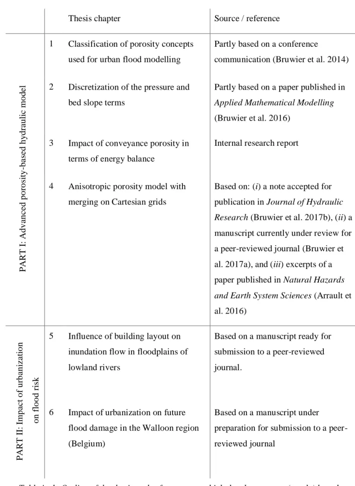
Thesis chapter Source / reference
P A RT I: A d v a n c e d p o ro si ty -b a se d h y d ra u li c m o d e l
1 Classification of porosity concepts used for urban flood modelling
Partly based on a conference
communication (Bruwier et al. 2014)
2 Discretization of the pressure and bed slope terms
Partly based on a paper published in
Applied Mathematical Modelling
(Bruwier et al. 2016) 3 Impact of conveyance porosity in
terms of energy balance
Internal research report
4 Anisotropic porosity model with merging on Cartesian grids
Based on: (i) a note accepted for publication in Journal of Hydraulic
Research (Bruwier et al. 2017b), (ii) a
manuscript currently under review for a peer-reviewed journal (Bruwier et al. 2017a), and (iii) excerpts of a paper published in Natural Hazards
and Earth System Sciences (Arrault et
al. 2016) P A RT I I: Im p a c t o f u rb a n iz a ti o n o n fl o o d ri sk
5 Influence of building layout on inundation flow in floodplains of lowland rivers
Based on a manuscript ready for submission to a peer-reviewed journal.
6 Impact of urbanization on future flood damage in the Walloon region (Belgium)
Based on a manuscript under
preparation for submission to a peer-reviewed journal
Table iv-1: Outline of the thesis and references on which the chapters are (partly) based. Equation Section (Next)
9
PART
I:
P
OROSITY
-
BASED HYDRAULIC MODEL
1. Classification of porosity concepts used for urban flood
modelling
This chapter is partly based on the conference communication “Mathematical formulation of
shallow water models with porosity for urban flood modelling” published in the proceeding of
the 11th International Conference on Hydroscience and Engineering, Hamburg, 2014 (Bruwier et al. 2014).
ABSTRACT: Shallow-water models with porosity have been developed to increase computational efficiency while preserving some of the subgrid-scale information on the topography and obstacles in the floodplains. This subgrid topographic information is lumped into one or several porosity parameters. However, existing approaches for the derivation of porosity-based shallow-water equations differ in their mathematical formulations, in the underlying assumptions, in the applicability ranges of the models as well as in the definition of the porosities (grid-based vs. related to a representative elementary volume, isotropic vs. anisotropic, depth-dependent vs. -indepth-dependent). In this chapter, we compare the different formulations and we highlight their respective strengths and limitations. This is based on quantitative analyses of not only idealized urban networks; but also of a real-world case study involving depth-dependent features. The analysis hints that grid-based, anisotropic and depth-dependent porosities should be preferred to reproduce optimally the detailed topographic data at a coarser scale.
PART I: Porosity-based hydraulic model
10
1.1. Introduction
Due to climate change and other environmental changes such as growing urbanization, floods are expected to become more frequent and severe in the future. However, the magnitude of these changes remains highly uncertain. This calls for the analysis of a high number of scenarios and, therefore, many runs of the numerical models are necessary. Simultaneously, high-resolution topographic data have become widely available. Consequently, the present need is mainly for high performance computational models which take full benefit of the available detailed data. Since detailed flood modelling in urban areas usually requires a fine discretization hardly compatible with computational efficiency, one option to improve this efficiency consists in using coarser grids while preserving some level of representation of obstacles (i.e. buildings, walls, …) within the cells by means of different subgrid modelling techniques.
One particularly crude approach relies simply on the standard shallow-water equations (SWE) with an additional flow resistance term to represent the overall influence of the obstacles. Despite its simplicity, a strong drawback of this approach is the poor use of the available topographic data (Yu and Lane 2006a, Dottori et al. 2013) and, hence, the sensitivity of the model to calibration (Yu and Lane 2006b).
Other subgrid parameterization methods enable the available topographic details to be preserved even on coarser grids thanks to the use of porosityparameters. These porosities represent the part of space not occupied by topographic obstacles, which are therefore free for water. For a given water level, the presence of these obstacles affects the volume of stored water and the exchange fluxes. Some authors use a single isotropic porosity parameter and therefore do not distinguish between storage and conveyance effects (Bates 2000, Defina 2000, Hervouet et al. 2000, Bates et al. 2003, Hervouet 2003, Guinot and Soares-Frazão 2006, Soares-Frazão et al. 2008, Velickovic et al. 2017), while others do distinguish these two effects by using anisotropic porosities (Lhomme 2006, Sanders et al. 2008, Chen et al. 2012a, 2012b, Guinot 2012, Schubert and Sanders 2012, Kim et al. 2014, 2015). Recently, Guinot et al. (2017) introduced the dual integral porosity model, in which the values of the variables at the cell edges are evaluated from the model solution by means of a closure equation. These porosity parameters are evaluated either at the scale of a Representative Elementary Volume (REV-scale porosity) (Hervouet et al. 2000, Hervouet 2003, Guinot and Soares-Frazão 2006, Lhomme 2006, Soares-Frazão et al. 2008, Guinot 2012, Velickovic et al. 2017) or at the grid scale (grid-scale porosity) (Bates 2000, Bates et al. 2003, Sanders et al. 2008, Chen et al. 2012a, 2012b, Schubert and Sanders 2012, Kim et al. 2014, 2015, Guinot et al. 2017). REV-scale porosity models are derived in the form of partial
Classification of porosity concepts used for urban flood modelling Formulations of the shallow-water equations with porosity
11 differential equations, whereas grid-scale porosity models are formulated in discretized integral form (although a differential form can be derived to study the wave celerity, for instance). Since the scale of REVs is typically one order of magnitude larger than the typical grid scale, grid-scale porosity models enable resolving flow variability at a finer scale than REV-scale porosity models (Kim et al. 2015). In addition, Chen et al. (2012b) and Guinot (2012) account for separate flow paths within a cell thanks to, respectively, a multi-layered approach and a multiple porosity model. Some methods enable considering varying storage capacity in the cells and effective flow area across the cell edges as a function of the water level by means of relationships (e.g., look -up tables) linking directly the water level to these parameters, without referring explicitly to the concept of porosity (Yu and Lane 2006a, McMillan and Brasington 2007, Stelling 2012, Vojinovic et al. 2013, Volp et al. 2013), while others do refer explicitly to depth-dependent porosity parameters (Özgen et al. 2016b).
Each of the methods involving porosity parameters requires a specific mathematical reformulation of the SWE. Depending on the authors, the modified SWE are derived in various ways, involving specific assumptions and limitations. This chapter provides first a classification of the different porosity-based mathematical formulations used so far to simulate urban floods. Next, the main conceptual assumptions are discussed based on data from an idealized test case and from a real-world case study.
1.2. Formulations of the shallow-water equations with porosity
First, the key concepts and notations used in the porosity-based models are defined (section 1.2.1) and the integral formulation of the SWE with porosity is presented (section 1.2.2). Next, we discuss two classes of models, based respectively on the REV-scale (section 1.2.3) and on the grid-scale formulation of the equations (section 1.2.4).
1.2.1 Definitions of key concepts
To derive the SWE with porosity, the three-dimensional Reynolds-averaged Navier-Stokes equations are space-averaged over a Control Volume (CV). A CV can be defined around any point of the urban area, no matter whether that point corresponds to voids or to an obstacle. The considered CVs have vertical boundaries, except at the bottom and at the free surface (Figure 1-1). The total volume of the CV is noted V, while V is the part of V filled with water (Figure f 1-1a). Similarly, the contour of V is noted V , while Vf is the part of V through which water can be exchanged (Figure 1-1b). For a given level z, the total horizontal surface included
PART I: Porosity-based hydraulic model
12 in the CV is noted , while the part of corresponding to water is f (Figure 1-1c). The contour of is noted , while f is the part of through which fluid can be exchanged (Figure 1-1d).
Figure 1-1 : Sketch of the CV and (a) the part V occupied by water, (b) the fluid-fluid f
exchange border Vf, (c) a horizontal surface at a given level z within the CV and its part occupied by water f, as well as (d) the fluid-fluid exchange border f of the horizontal
surface.
For a given water level z in a CV, two types of porosities may be defined. The first one, called
storage porosity (), quantifies the actual volume available in the CV to store water despite the presence of obstacles such as buildings (i.e. the void fraction in the CV). In general terms, this porosity is expressed mathematically as: ( )z Vf( ) /z V z( ). The second type of porosity, called
conveyance porosity (), quantifies the blockage effect by obstacles on the surface area actually available to convey water through the contour of the CV. It may be expressed mathematically as:
( )z V zf( ) / V z( )
. In the next sections, the porosity parameters and are referred to as, respectively, volumetric storage porosity and aerial conveyance porosity.
In literature, the following alternative definitions of porosity parameters have been used extensively. At a given water level z, the areal storage porosity
is the fraction of the horizontal surface within the CV which is free for water:( )z f( ) /z ( )z
Classification of porosity concepts used for urban flood modelling Formulations of the shallow-water equations with porosity
13 Similarly, the linear conveyance porosity is the fraction of the length a border of , which is free for water exchanges at a given water level z:
( )z f( ) /z ( )z
(1-2)
In most previous studies, the blockage rate by the considered obstacles is considered independent of the water level z. In such particular case, the following equalities hold between the different porosities defined above:
and
. For this reason, many authors used only definitions (1-1) and (1-2), and referred neither to nor to .When the conveyance porosities are the same along x and y directions and are assumed equal to the storage porosity, all porosity effects are lumped into a single parameter which is called
isotropic porosity. In others cases, the porosities are referred to as anisotropic.
The Representative Elementary Volume (REV) was originally defined as the smallest CV for which a property (such as porosity) becomes independent of the size of this CV. The concept of REV is used extensively in other fields of physics such as modelling of flow and transport processes in porous media (Bear 2013), rainfall-runoff modelling (Wood et al. 1988) or mechanics of heterogeneous, composite and granular material (Drugan and Willis 1996, Kanit et al. 2003, Wiacek et al. 2012).
The size of a REV depends on the expected accuracy in the estimation of the property and on the property itself. Typical sizes vary across several orders of magnitude. For instance, REV in a sand medium was estimated at about 10 mm3 (Costanza-Robinson et al. 2011). For granular plant material, Wiacek et al. (2012) report REV sizes in-between five and twenty times the size of the largest particles, while REV sizes are evaluated in-between a thousand and ten thousand crystals in steel material (Bettaieb et al. 2012).
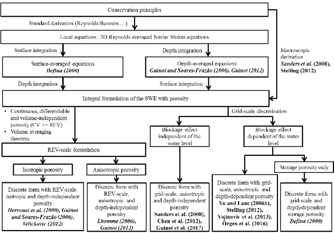
1.2.2 Integral formulation
The flow chart in Figure 1-2 provides an overview of the main approaches used in literature to derive SWE with porosity, as well as the different forms obtained. For each of them, Table 1-1 summarizes the main characteristics and limitations, as detailed hereafter. For each approach listed in Table 1-1, we report only the main references to this approach in Figure 1-2.
PART I: Porosity-based hydraulic model
14
Figure 1-2 : Derivations and formulations of the porosity-based models. Only the former reference to each kind of approach listed in Table 1-1 are reported.
Table 1-1: Summary of the porosity-based models, as well as the main characteristics and limitations.
Classification of porosity concepts used for urban flood modelling Formulations of the shallow-water equations with porosity
15 To derive the SWE with porosity, the three-dimensional Reynolds-averaged Navier-Stokes equations, which express the conservation of mass and momentum, are integrated over a CV such as defined in section 1.2.1. Combined with the standard assumption of shallow flow (including hydrostatic pressure distribution), this leads to the integral formulation of the SWE with porosity. In practical terms, the volume integration over the CV may involve a depth-averaging operation followed by a surface averaging over the horizontal projection of the CV, or vice-versa (Figure 1-2). Most authors used the former approach as they started from the standard SWE without porosity (Guinot and Soares-Frazão 2006, Guinot 2012); but Defina (2000) used a surface-average followed by a depth-surface-average. While both approaches should result in identical volume-averaged equations, Defina (2000) only considered storage porosity in her formulation.
Instead of performing a mathematical integration of local equations over the CV, an alternate approach consists in applying directly the conservation principles to a CV involving obstacles and, hence in deriving macroscopically the integral formulation of the SWE with porosity. This approach was followed by Sanders et al. (2008) and Stelling (2012). Sanders et al. (2008) obtained the following expressions for the integral formulation of the SWE with porosity:
0 ihd ih d t
u n (1-3)
0 2 2 1 1 2 2 f D add ih d ih d t gih d gih d ic Vd S
u uu n n n u (1-4)where i is a binary density function equal to 1 in void areas and to 0 otherwise, u u ux; y the horizontal velocity, n n nx; y the unit outward vector normal to , g the gravity acceleration,
0
h the water depth for a uniform free surface within the CV, c accounts for the bottom shear Df
stress, V u2xu2y and Sadd is an additional loss term detailed hereafter.
The fluid pressures acting on the obstacles and on the bottom are lumped into a “quasi-conservative” divergence term (first term on the right hand side of Eq. (1-4)), consistently with the formulation introduced by Valiani and Begnudelli (2006). This divergence term is discussed in detail in section 2.3.
PART I: Porosity-based hydraulic model
16 As reported in Table 1-2, the additional loss term may account for the drag force applied on buildings (Hervouet et al. 2000, Sanders et al. 2008, Guinot 2012, Özgen et al. 2016b). A generalized scalar drag formula is used to take into account energy losses near the obstacles:
0 1 where 2 b add D D D b S ic Vd c c ah
u (1-5)where c is a drag coefficient and a is an obstruction parameter defined as the average width of 0D
obstruction per unit of the CV area. The drag force term depends on the flow velocity magnitude and direction, as well as on the pattern of obstacles. Schubert and Sanders (2012) propose a simpler direction-independent formulation of the obstruction parameter based on the average width of obstructions at the cell edges. Guinot et al. (2017) proposed an anisotropic building drag term by extending the scalar drag coefficient c to a second order drag tensor. Db
For some authors, the additional loss term is simply a head loss term. Guinot and Soares-Frazão (2006), Lhomme (2006) and Soares-Frazão et al. (2008) use the additional head loss term to account for head losses due to crossroads, expansions and constrictions of the flow. While Lhomme (2006) use a second order tensor of head loss coefficients, Guinot and Soares-Frazão (2006) and Soares-Frazão et al. (2008) use a Borda-like formula which evaluates the head loss due to a sudden variation in the flow cross-sectional area through a so-called contraction coefficient. This formulation is based on two idealized arrangements of buildings (aligned vs. staggered) and on an initial estimation of the flow direction in the urban area. While the approach proved to be effective to reproduce flows in such idealized configurations, its applicability for real-world urban areas has not been proven yet.
Velickovic et al. (2016) consider the anisotropic nature of the drag loss term through a fourth order dragtensor of head losses. However, the authors acknowledge that future work is required to improve and generalize the methodology and to develop a general calibration procedure.
Classification of porosity concepts used for urban flood modelling Formulations of the shallow-water equations with porosity
17
Table 1-2: Summary of the different formulation of the losses related to buildings.
1.2.3 REV-scale formulation
The integral formulation derived in section 1.2.2 gives an average description of the SWE at each point in space. Provided that the planar extent of the CV is larger than the size of the REV related to the porosity parameter, the storage porosity becomes independent of . Moreover, according to Sanders et al. (2008), the porosity becomes continuous, differentiable and isotropic if the size of the CVs for which porosities are computed is higher than the size of the REV. Therefore, the discontinuous binary density function i is replaced by a continuous, differentiable and isotropic function
, representative of mathematical expectation values of the presence of void at the scale of the REV. The REV-scale formulation (called differential formulation by Sanders et al. (2008)) of the SWE with porosity is then derived from the application of the local volume averaging theorem (Whitaker 1967, Vafai and Tien 1981, Gray and Hassanizadeh 1989) to the integral formulation.The REV-scale formulation of the SWE with porosity was introduced by Defina (2000) to handle partially wet and irregular topographies. His work was extended by Bates (2000) and Bates et al. (2003) to represent dynamic wetting and drying of cells in a finite volume scheme. The obtained equations involve a depth-dependent areal storage porosity. This is a unique feature of these
PART I: Porosity-based hydraulic model
18 models since all subsequent contributions based on the REV-scale formulation of the equations assume that the porosity is depth-independent (Table 1-1).
Hervouet et al. (2000) proposed a REV-scale formulation of the SWE with depth-independent isotropic porosity for urban flood modelling. Guinot and Soares-Frazão (2006) derived mathematically an extended formulation, which was later applied by Soares-Frazão et al. (2008). Numerical discretizations of the SWE with isotropic porosity were proposed by Cea and Vázquez-Cendón (2010), Finaud-Guyot et al. (2010) and Mohamed (2014).
Compared to the standard SWE, the fluxes and source terms in the resulting equations were modified as follows (Guinot and Soares-Frazão 2006):
S t x y U F G , (1-6) with 2 2 0, , 2 2 0, , 0 , / 2 , , / 2 x y x x x y x f x y x y y y f y h hu hu hu hu gh hu u S S hu hu u hu gh S S U F G S (1-7) 2 2 0, ; 0, 2 2 b b x y z h z h S gh g S gh g x x y y
(1-8)
1/ 2 2 2 , 2 4/3 1/ 2 2 2 , 2 4/3 1 ; 1 f x x y x x f y x y y y S gh u u u s K h S gh u u u s K h (1-9)with h the water depth,
the depth-independent isotropic porosity, ux and u the x- and y- ydepth-averaged velocity components, S0,x and S0, y the topographic source terms in the x- and
y- directions. Sf x, and Sf y, include the energy losses due to bottom and wall shear stress, as well
as those due to variations of velocities in the x- and y- directions within the CV, zb the mean bottom elevation, sx and s the head loss coefficients accounting for the local variations of y velocities in the x- and y- directions and K the Strickler coefficient. The additional term in S0,x
and S0, y represents the pressure applied on the obstacles.
Lhomme (2006) extended Eq. (1-6) to anisotropic porosities. Besides the storage porosity , conveyance porosities x and y were introduced and assigned to the border fluxes F and G.
Classification of porosity concepts used for urban flood modelling Formulations of the shallow-water equations with porosity
19 However, the anisotropic conveyance porosities were not properly defined by Lhomme (2006), who displayed the resulting equations but did not apply them for urban flood modelling.
Guinot (2012) described a multiple porosity model in which the domain is subdivided into five types of regions. They correspond, respectively, to obstacles without voids, regions with water at rest, regions of isotropic 2D flow, regions of anisotropic 1D flow and interconnections between the 1D anisotropic flow regions. These regions may exchange mass and momentum based on local differences in, respectively, water levels and energy heads. In each type of region, a specific formulation of the SWE is used for the computation of water depth and flow velocity. This multiple porosity model is reported to give more accurate results than a standard isotropic porosity model; but the a priori determination of the different flow regions is particularly complex for real-world urban areas.
Velickovic et al. (2016) proposed a new REV-scale formulation in which the anisotropy of the urban area is indirectly taken into account through a closure expression including drag and dispersion terms in the momentum equation. However, the authors acknowledge that these closure relations fail to reproduce real-world anisotropic flow and that calibration of the model remains an unsolved issue for general cases.
Based on simple considerations on idealized Cartesian and periodic urban networks, Guinot (2012) suggests that a REV would not exist for real-world urban areas. However, he argues that the error on the isotropic porosity evaluation is of the same order as other errors in the model, such as the estimation of the friction coefficient. According to him this enables the use of the REV-scale formulation to model urban floods with a reasonable accuracy.
PART I: Porosity-based hydraulic model
20 1.2.4 Grid-scale formulation
The direct discretization of the integral formulation avoids questionable assumptions concerning the size of the REV because porosities are defined here directly at the grid scale as discrete cell -properties.
Sanders et al. (2008) discretized directly the integral formulation of the SWE based on a non-staggered grid and a Godunov-type finite volume method:
n 1
n
n* j j j j j j k k k k k k h h t h
u n (1-10)
* 0 * , 1 2 2 , 1 2 2 1 1 j n n j f b D D j j j j j n n j j j j k k k k k k k k k k k gh V t c c h g h t h h h
u u u u n n n (1-11)where n represent a time step and n*is an intermediate time step in-between n and n+1.
The depth-independent porosities and are defined at the grid scale as cell- and border-properties (Table 1-1), making them mesh-dependent. Moreover, since the conveyance porosities are computed at borders, a conformal meshing is required to capture correctly the conveyance impact of obstacles at borders (Sanders et al. 2008). This requirement of a conformal meshing is a limitation for the maximum size of the coarse meshes, particularly in heterogeneous urban areas. Sanders et al. (2008) and Kim et al. (2015) demonstrated that the grid-scale formulation gives more accurate results than the REV-scale formulation.
Yu and Lane (2006b) and McMillan and Brasington (2007) employed a depth-dependent parametrization of the volume of water stored within the cells and of the cross-sectional areas at their borders in the context of the 2D diffusive wave equations. A multi-layered model was developed by Chen et al. (2012b) to reflect separate flow paths within a single coarse cell using non-inertia SWE.
Among others, Cea et al. (2010) showed that fully dynamic two-dimensional models give generally better results than simplified descriptions such as diffusive wave-based description for urban flood modelling.
Stelling (2012), Volp et al. (2013) and Vojinovic et al. (2013) used finite volume approaches, based on staggered grids, for solving the integral formulation of the SWE with porosity (Table 1-1). The two main unknowns, i.e. the volume of stored water and the mean velocity, are
Classification of porosity concepts used for urban flood modelling Analysis of some major assumptions of the existing formulations
21 respectively assigned to cells and to borders. Lookup tables are used to relate the water level in each cell to, respectively, the available volume for water storage and the cross-sectional area for fluid exchange through the borders of the cells. This feature enables the model to account for the effect of obstacles on the available volume for water storage and on the fluxes even when these obstacles get submerged. Although these authors do not refer explicitly to porosities, the lookup tables act as depth-dependent anisotropic porosities and are therefore of particular relevance for the following of this chapter.
The depth-independent grid-scale formulation was extended to depth-dependent porosity by Özgen et al. (2016). However, the application of the depth-dependent formulation was restricted to rainfall-runoff in an idealized urban catchment.
Recently, Guinot et al. (2017) have improved the grid-scale formulation by distinguishing the fluid velocity at cell centres from those along the cell edges. They use a closure model to evaluate the latter from the value of the former. Additionally, they incorporate a transient momentum dissipation coefficient, which improves the reproduction of wave propagation speeds for highly transient positive waves; but it requires a case-by-case calibration. This model is not discussed here but in section 4.3.3.
1.3. Analysis of some major assumptions of the existing formulations
Most standard formulations of the SWE with porosity presented in Table 1-1 were derived considering depth-independent porosities. Moreover, all REV-scale formulations of the SWE with porosity were obtained under the following additional assumptions: differentiability of all variables (i.e. flow properties and porosities), as well as the size of the CV being larger than theREV. Finally, the absence of a proper definition of an anisotropic conveyance porosity in the
REV-scale formulations leads to the use of an isotropic porosity by several authors. These major assumptions are analysed in this section based on an idealized urban network and on a real-world urban area.
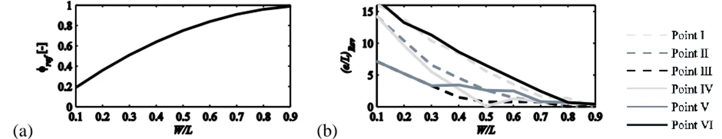
1.3.1 Test cases: idealized urban network and real-world urban area
Guinot (2012) analysed the size of REVs for periodic Cartesian urban networks with depth-independent porosities. The extent of the urban network was assumed infinite in all directions. The widths of the streets W and of the obstacles W were considered as variable parameters to b