Conceptual model of hydrogeological information for a GIS-based
Decision Support System in management of artificial recharge in
semi-arid regions
P.Wojda1, R. Gogu3, S.Brouyère1,2
1
Hydrogeology & Environmental Geology, GEOMAC Department and 2Aquapôle – ULg,
University of Liège, Belgium 3
GeoHidroConsult, Romania
Corresponding author: Piotr.Wojda@ulg.ac.be
ABSTRACT: The semi-arid regions of the Mediterranean basin face water problems due to particular climatic conditions, precipitation shortages and different human activities stimulating pressures on the main water source: groundwater. The spatio-temporal inadequacy of water supply and demand in terms of quantity and quality causes overexploitation in dry periods, which can induce various problems such as seawater intrusion, biogeochemical changes, base flow reductions etc. The objective of the GABARDINE project (“Groundwater
Artificial recharge Based on Alternative sources of wateR: aDvanced INtegrated technologies and managEment”) is to identify alternative sources of water and to investigate the
environmental and economic feasibility of artificial recharge of aquifers. To meet the objective, a GIS-based Decision Support System is being developed. Problems being spatially and temporally distributed, it is necessary to store all needed data in a well structured geospatial database. This database is being conceived according to a blue-print UML conceptual model of hydrogeological information, based on internationally accepted norms and specifications from ISO and OGC, adapted due to the particularities of the ArcGIS desktop implementation platform.
KEYWORDS : hydrogeological information, geomatics, conceptual model, decision support system, DPSIR.
1. Introduction
Groundwater resources are the main source of freshwater in many arid and semi-arid regions, especially in the Mediterranean basin. In dry seasons, overexploitation problems appear and can provoke seawater intrusion or some biochemical changes. Alternative sources of water have to be explored and followed up by economical and environmental feasibility studies of their use. The use of aquifers as the primal facility for large scale storage of water coming from these alternative sources should be then investigated along with techniques for artificial recharge and injection of that water, a quality and quantity monitoring network and natural purification and filtration process.
In order to assure this complex, integrated scarce water resources management, one of the main objectives of the GABARDINE project is to develop a GIS-based Decision Support System. One of the integral parts of the GIS-based DSS is a Geospatial Database containing identified and required information, not only from the hydrogeological domain (Figure 1).
simulation results, and scenarios) and Analysis Tools to provide decision makers with valuable tools in water resource management.
The objective of this paper is to present the main concepts governing the development of a geospatial database for the project. It underlines the fact that the geospatial database should be based on a conceptual model of hydrogeological information and should contain additional data to deal with integrated water resource management problems.
GIS-based DSS General Architecture
Geospatial Database Tools
Analysis Tools
Decision GIS BASED INTERFACE
Embedded tools External tools
Fig. 1. GIS-based Decision Support System general architecture.
2. GIS-based Decision Support Systems and geospatial database
In order to deal with integrated water resource management, different methodologies, tools and techniques have to support decision makers in their decisional processes. In the context of the GABARDINE project, it has been decided to structurally describe the faced water management problem in a given region using the DPSIR framework proposed and supported by the European Environmental Agency. The DPSIR approach consist in establishing a chain of causal links between Driving forces (economic sectors, human activities), Pressures (emissions, waste), the physical, chemical and biological State of the environment and Impacts on ecosystems, human health and natural resources, so as to identify the most relevant Responses to be given and to evaluate their efficiency from a socio-economical point of view (Kristensen, 2004). In a more general context, the DPSIR concept was also implemented as a structural system in the MULINO project (Mysiak et al., 2005). From such an integrated point of view, the management of water resources and associated information are not limited to the groundwater reservoir. One has to deal from upstream (pressures) to downstream (impacts), so any data management system should integrate more information than just hydrogeological data (land cover, soil, surface water etc).
Secondly, knowing that all that information is spatially and temporally distributed, it is necessary to use computerised application assistance in data analysis, treatment and water management. In cartography, and especially in modern hydrology and hydrogeology research fields, the use of geoinformation systems (GIS) is more and more common. These systems include different components, such as data, hardware, software, procedures, operators and analytical problem statement (Meeks and Dasgupta 2004).
Within the GABARDINE project a GIS-based Decision Support System is under development to respond to these specific needs in scarce water resources management and to integrate DPSIR approach along with spatial analysis. Required data, which are essential to GIS-based DSS, have to be stored in a well structured geospatial database. This database will enable an easy data access, internal exchange and spreading not only between project partners but it will also assure data availability for a larger community, if needed. It could be a first step contributing to a European or International Spatial Data Infrastructure.
Summarising a few definitions of a Decision Support System, we can refer to Power (1997): “…any system supporting decision-making, including executive information systems, executive support systems, geographic information systems, online analytical processing and software agents, may be called a DSS”. In the GABARDINE project, the GIS-based DSS will be used for several purposes such as the definition of alternative water exploitation scenarios optimising the degree of water recovery and minimizing the impact of stress factors on water resource, the quantification and optimisation of the artificial recharge efficiency, to evaluate impact of water management and exploitation and particularly to support data exchanges between the various components of the GABARDINE project: water resource, water exploitation, quantification of fluxes, stress factors, vulnerability and risk assessment, uncertainty and sensitivity analysis.
The manipulation of hydrogeological information in GIS-based DSS and geospatial database implementation depend principally on applied conceptual models of hydrogeological information. Furthermore, hydrogeology, as a specific domain, requires a specific terminology for the development of the conceptual model, combined with general information and geomatics concepts (Michalak and Leśniak, 2003), described here after.
3. Conceptual model for geospatial database
The most important step in the GIS-based DSS development process is the design of a conceptual model of required information. Firstly, a large spectrum of data has to be identified, as many related domains are concerned: geography, geology, hydrology, hydrogeology, meteorology, water engineering, land management and others. Secondly, existing projects and data models have to be explored in order to identify possible interactions and contributions. Furthermore, the proposed conceptual model and its implementation in the geospatial database should be conformant with internationally accepted norms and specifications.
An Object-Oriented approach for the design of geospatial database has a lot of advantages. When explored and applied by geospatial analysts, it assures interoperable data exchanges between different project actors. Moreover, in the future it will be possible to implement this conceptual model in any other Geographic Information System. Such a model is easily extensible and adaptable once its structure is unambiguously described. Actually, there are two recognized technical groups developing standards and specifications for geospatial information: International Organisation for Standardisation with Technical Committee 211 (ISO/TC 211) and Open Geospatial Consortium (OGC). They recommend the use of the UML diagrammatic notation. Furthermore, as conceptual modelling in geomatics does not require all methodologies and possibilities of UML notations, a narrower geomatic profile has
only class diagrams and packages in ISO 19103, with some contextual clarifications: ISO 19109, 19118, 19136.
The conceptual model of hydrogeological information is designed in the UML to be directly implementable into Object-Oriented Databases or Relational Databases. Moreover, several existing patterns or already implemented data models have been explored:
• Hydrogeological Database: University of Liège expertise (Gogu et al., 2001); • ArcHydro: ESRI hydrological data model (Maidment, 2002);
• Groundwater Model: ESRI, Strassberg Ph.D. dissertation (Strassberg, 2006); • The Australian National Groundwater Data Transfer Standard, (1999);
• XMML (eXploration and Mining Markup Language): as a GML application schema (Cox, 2001);
• GIS database developed in WaterStrategyMan European Project (ProGEA S.r.l, 2004); • GML: Geography Markup Laguage, currently undergoing standardization as ISO
19136 (Lake, 2005);
• Water Framework Directive and its Geospatial information working group (Vogt, 2002);
These models do not permit directly to deal with integrated water resource management. They need to be adapted. It was therefore necessary to prepare a new, more complete and exhaustive model of extended hydrogeological information, which can be implemented on many available platforms.
The conceptual model which is being developed for GABARDINE is illustrated in Figure 2, 3 and 4. It is also important to notice, that this model is adapted to and directly implementable in ArcGIS environment. First, the HydroSite abstract feature is defined. It constitutes a superclass which can represent any hydrogeological feature such as Well, Excavation, Spring, WaterBody and MonitoringStation abstract classes with GroundwaterBody and GroundwaterMonitoringStation classes respectively, which will inherit from it (Figure 2). Each feature class has its properties (ISO 19109) and, for a particular feature instance, a property has its value: a Well feature class has a “type” property: “traditional well” and a “depth” property: “5m”. Furthermore, there are also different associations (and aggregations or compositions) amongst feature classes (Figure 3). For instance, a Well class is associated with Screen, Grouting, Gravel pack and Casing classes, with some additional conditions on each relationship (attributed or non-attributed one) such as cardinality and a role at the ends of associations, described in the Figure 3.
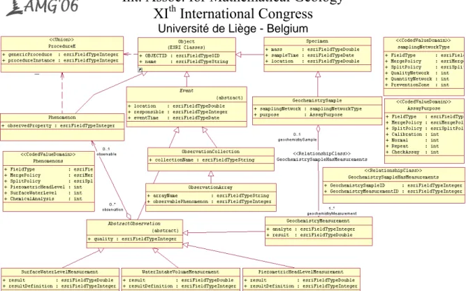
Different observations and measurements are illustrated in Figure 4. This model adapts recommendation and discussion documents from OGC (03-022r3 and 05-087r3), in order to be implementable in GIS-based platforms. Observations and measurements are seen as abstract Events with several properties such as location, responsible or eventTime. Specialised observations can be regrouped in an ObservationCollection, when they concern different phenomena, or regrouped within an ObservationArray when an observed phenomenon is homogenously typed, for instance Piezometric Head Level Measurements for a particular well taken during a pumping test.
Fig. 2. GABARDINE Spatial Database - Progress in conceptualisation of spatial data model – hydrogeological features
Fig. 3. GABARDINE Spatial Database - Progress in conceptualisation of spatial data model – well construction elements
Fig. 4. Applicational conceptual model of measurements and observations implemented in geospatial database.
4. Conclusion
Geospatial information related to hydrogeological features needs to be structured by the means of Geomatics such as UML and presented by clear, platform independent conceptual data models, based on international standards. Such models, implemented in GIS-based Decision Support Systems will facilitate integrated water resources management and information exchange between different actors from all water related domains. In the case of the GABARDINE project, a new conceptual model permits an easy data integration and data exchange by programmed interfaces and eventually assimilation within International Spatial Data Infrastructures.
Acknowledgments : This work is supported by the European Union FP6 STREP Project GABARDINE (Project no. 518118-1) under the thematic priority, sustainable development, global change and ecosystems
REFERENCES
Cox, S.J.D., (2001), Geologic Data Transfer Using XML, www.digitalearth.net.cn/GISConference/Geologic%20data%20transfer%20using%20xml.pdf; Gogu, R. C., Carabin G., Hallet V., Peters V., Dassargues A., (2001), GIS based hydrogeological
databases and groundwater modelling, Hydrogeology Journal 9 (6): 555-569;
Kristensen, P. (2004), The DPSIR Framework. Workshop on a comprehensive / detailed assessment of the vulnerability of water resources to environmental changes in Africa using river basin approach, UNEP Headquaters, Nairobi, Kenya;
Maidment, D. R., (2002), Arc Hydro: GIS for Water Resources. ESRI Press, Redlands, California; Meeks, W. L., Dasgupta, S., (2004), Geospatial information utility: an estimation of the relevance of
geospatial information users, Decision Support Systems 38: 47-63;
Michalak, J., Leśniak, P., (2003), Features and coverages in hydrogeological information, Acta Geologica Polonica, Vol. 53, No.3: 247-255;
Mysiak, J., Giupponi, C., Rosato, P., (2005), Towards the development of a decision support system for water resource management, Environmental Modelling & Software 20: 203-214.
National Groundwater Committee Working Group on National Groundwater Data Standards, (1999), The Australian National Groundwater Data Transfer Standard;
Open Geospatial Consortium Inc., (2006), Observations and Measurements, OGC 05-087r3, http://portal.opengeospatial.org/files/?artifact_id=14034,
Open GIS Consortium Inc., (2003), Observations and Measurements, OGC 03-022r3, http://portal.opengeospatial.org/files/?artifact_id=1324,
Power, D. J., (1997), What is DSS? DSstar, The On-Line Executive Journal of Data-Intensive Decision Support 3;
ProGEA, S.r.l., (2004), A WaterStrategyMan DSS, A comprehensive Decision Support System for the development of sustainable water management strategies, Bologna, Italy : 187;
Smeets, E., Weterings, R., (1999), Environmental indicators: Typology and overview. Copenhagen, European Environmental Agency:19;
Strassberg, G., (2005), A geographic data model for groundwater systems, Ph.D. Thesis, University of Texas, Austin;
Vogt, J., (2002), Guidance Document on Implementing the GIS Elements of the Water Framework Directive.