Former hypothesis about the installation
of the river network
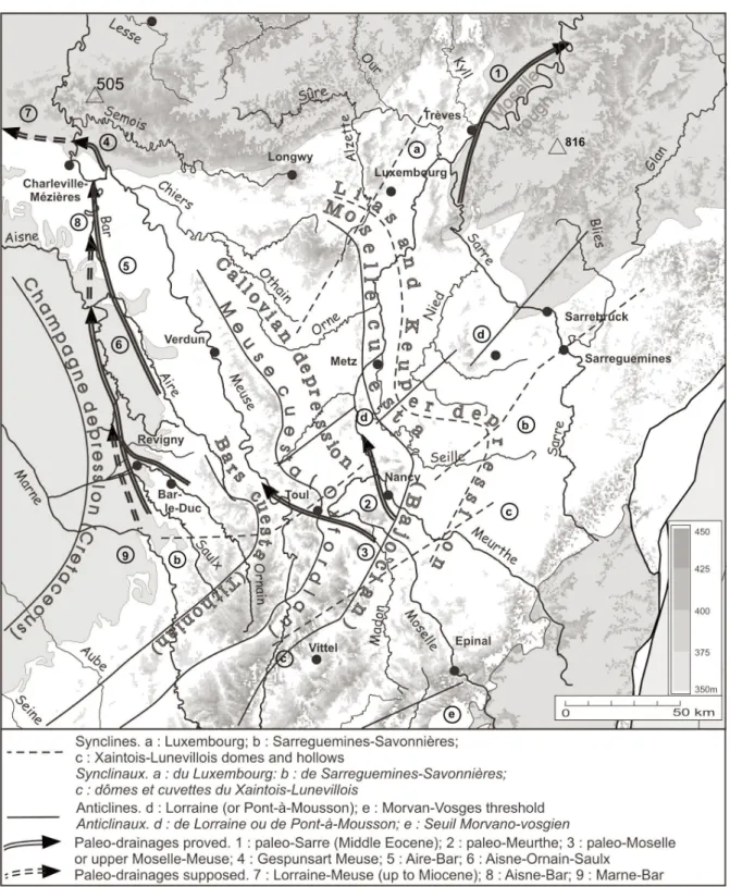
In the Eastern Paris Basin, the problem of the installation of the river network was pointed out since the end of the nineteenth century (Davis, 1895). In fact, in the Northern Lorraine and Champagne regions, the main rivers flow northwards updip and cross through the Ardenne and Rhenish Shield, which are higher than the Lorraine plateaus (450 m at the “Borne de Fer” compared to 816 m in the Hunsrück and 746 m in the Eifel Massifs) (Fig.1).
Since the nineteenth century, the authors imagined a river network installation on a planar continental surface which was successively the northwards-dipping peneplain of Davis (1899) and the Oligocene-Miocene main surface of Tricart (1948) which was later tilted northwards and reworked in the Mio-Pliocene period.
Some German authors suggested an installation of the rivers on a accumulation surface built with detritic materials which would have buried the cuestas relief (Liedtke, 1989). However, the correlative remains of such a surface were not clearly evident.
New hypothesis : installation on the Upper
Cretaceous marine regression surface
Nevertheless, the more recent papers have insisted on the existence of Eocene paleoreliefs and paleovalleys incised into the Eifel basement (Löhnertz, 1978, 1994) and have also pointed out the polygenic surface which is preserved at the top of the Lorraine cuestas. This surface was completed in the Pliocene because it is anterior to the Plio-Pleistocene downcutting of the rivers (Le Roux and Harmand, 1998; Le Roux, 1999, 2000; Harmand, 2001).According to the eustatic reconstructions levels (Haq et al., 1987), the East of the Paris Basin may have been covered with Upper Cretaceous formations. Indeed, such a cover exists in the bordering regions of Burgundy, Champagne and Ardenne where there diachronic remnants (residual flints) were dated from Maastrichian in the North-East, in the “Hautes Fagnes” (Demoulin, 1995).
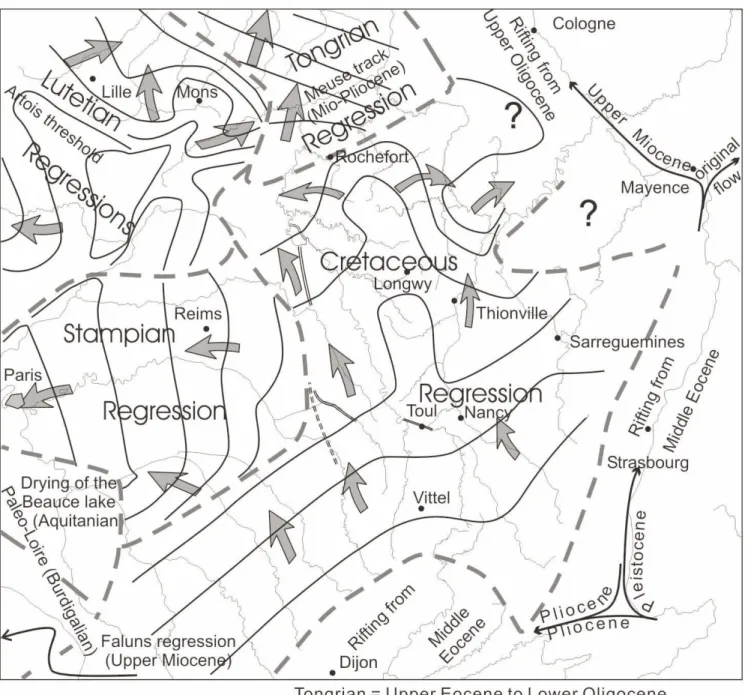
The retreating of the Upper Cretaceous regression sea organized the Eastern Paris Basin rivers network. So, the rivers grew on the Cretaceous marine regression surface retreating to the North (Le Roux et al., 2003) (Fig. 3, 5). Therefore, the hydrographic network appeared sooner in the South, later in the North. This diachronic network would have grew more or less perpendicularly to the regressive shorelines towards the early Cenozoic gulf which preexisted in the North Sea area (Ziegler, 1988). So, the installation of the rivers on the Ardenne and Rhenish Shield, overlayed by the Cretaceous Chalk, occured when the Ardenne-Eifel block was turned into a low plain, allowing the installation of the rivers draining to the North. Later, the Chalk is washed out by erosion, especially during the hot and wet climates which prevailed in the beginning of the Cenozoic (Quesnel, 1997), and the hydrographic network embanked into the basement and the discordant Triassic and Jurassic formations, under the Infracretaceous surface.
Consequences of the regressive
shorelines hypothesis
This Infracretaceous surface, which corresponds to the 400 m surface in the Eastern Paris Basin (Fig. 2), was of course reworked during the Cenozoic, as proved by the Palaeogene deposits in the Northern lorraine and the Ardenne-Eifel Massif (Löhnertz, 1978, 1994; Voisin, 1988; Quesnel et al., 2002).
Origin of the hydrographic network in the Eastern
Paris Basin and its border massifs.
Hypothesis, structural, morphologic
and hydrographic consequences
Dominique HARMAND
Jacques LE ROUX
(1)(2)Géologie de la France, 2003, n° 1, 105-110, 5 fig.
Key words: Drainage patterns, Regression, Upper Cretaceous, Eastern Paris Basin, Ardenne, Paleosurfaces.
(1) Le Parc Fleuri, 3 rue Gabriel Fauré, 54500 Vandoeuvre-lès-Nancy, France. [email protected]
(2) Laboratoire de Géographie, Campus Lettres-Sciences Humaines, Université de Nancy 2, BP 33-97, 54015 Nancy Cedex, France. [email protected]
ORIGIN OF THE HYDROGRAPHIC NETWORK IN THE EASTERN PARIS BASIN
Structural consequences
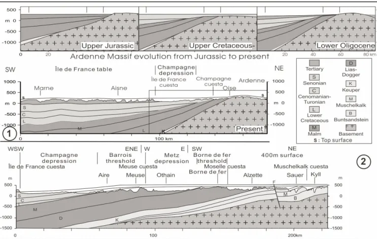
The continuity of the 400 m surface and the low variations in height of this surface which truncates at once the Triassic-Jurassic sedimentary cover and the Hercynian basement, proves the great stability of the Eastern Paris Basin since the end of the Mesozoic.
Also, the shape of the Eastern Paris Basin mainly dates from the end of the Cretaceous (Fig. 4).
Accordingly, during the Pyrenean and Alpine compressive stages, only minor vertical deformations would have taken place, and the extensive Oligocene movements occurred only in local normal faults and small grabens (Le Roux, 2000).
The uplift of the border old blocks had just a tiny influence on the present morphostructural framework of the Eastern Paris Basin. The edge between the Paris Basin
ORIGIN OF THE HYDROGRAPHIC NETWORK IN THE EASTERN PARIS BASIN
and the Hercynian massifs corresponds clearly to an important flexure of the Infra-Cretaceous surface (Le Roux and Harmand, 2003).
Morphological and hydrographic consequences
The model of the river network installation explains the non conformity of the rivers with the tectonic features and the top surface.
The rivers courses have kept a great stability in the Eastern Paris Basin, since the end of the Upper Cretaceous. They grew downstream in the Tertiary periods, especially in the Belgium regions (Grimbérieux et al., 1995;
Robaszynsky et Dupuis, 1983) and in the middle of the Paris Basin during the episodes of retreating seas.
The main rivers captures (Haute Moselle, Aire, Aisne, Harmand, 1992) date from the Quaternary, and occure still today. These hydrographic reorganizations were and are still controlled by selective erosion and climatic variations.
Conclusions
The hypothesis about the hydrographic network installation in the Eastern Paris Basin on the Upper Cretaceous marine regression surface points out that :
ORIGIN OF THE HYDROGRAPHIC NETWORK IN THE EASTERN PARIS BASIN
- the main Mesozoic subsidence guidelines, which appeared at the beginning of the Jurassic, were still active in the end of the Cretaceous. Indeed, the tributaries of the Seine river, from the Yonne to the Aisne rivers, flow towards the middle of the Paris Basin; the Maas river flows northwards on the Barrois threshold; the Mosel river flows towards the Luxembourg syncline;
- the structuration of the Eastern Paris Basin was almost completed at the end of the Cretaceous. The uplift of the border old blocks has not any influence on its present structure;
- the rivers courses were directly inherited from the paleogeographic features of the end of the Cretaceous, which involve the surimposition of the valleys in the Hercynian Ardenne and Rhenish Shield. Therefore, the hydrographic network has had a great stability for 65 Ma, and had embanked vertically, with few variations along its course;
- three factors explain the Quaternary piracies : the regressive erosion of the Rhine tributaries, because of the subsidence of the Cologne and Rhine grabens, the important incision of the tributaries in the Seine, and, the renewal of the positive tectonic movements in the Ardenne massif.
ORIGIN OF THE HYDROGRAPHIC NETWORK IN THE EASTERN PARIS BASIN
Fig. 4.- Geological and morphological cross-sections.
ORIGIN OF THE HYDROGRAPHIC NETWORK IN THE EASTERN PARIS BASIN
References
Davis W.M. (1895) - La Seine, la Meuse et la Moselle. Ann. de géographie, 25-49.
Davis W.M. (1899) - The drainage of cuestas. Proc. Geologist’s Assoc., XVI, part II, may, 75-93.
Demoulin A. (1995) - L’Ardenne des plateaux, héritage des temps anciens. Surfaces d’érosion en Ardenne. In: L’Ardenne. Essai de géographie physique. Hommage au professeur A. Pissart. Liège (1995), 68-93.
Grimberieux J., Laurant A., Oer P. (1995) - Les rivières s’installent. In: L’Ardenne : Essai de Géographie Physique. Hommage au Professeur A. Pissart, A. Demoulin, Directeur scientifique, 94-109.
Haq B.U., Hardenhol J., Vail R.P. (1987) - Chronology of fluctuating sea levels since the Triassic. Science, 235, 1156-1167.
Harmand D. (1992) - Histoire de la vallée de la Meuse Lorraine. Presses Universitaires de Nancy (Coll. “Etudes géographiques”), 146 p.
Harmand D. (2001) - Évolution morphologique cénozoïque des vallées de l’est du bassin de Paris. Comparaison avec le sud du bassin. Territoires, paysages et héritages. Mélanges offerts au professeur J.-C. Bonnefont. Université de Nancy, 41-49.
Le Roux J. (1980) - La tectonique de l’auréole orientale du Bassin de Paris. Ses relations avec la sédimentation. Bull. soc. géol. Fr., XXII, n° 4, 655-667. Le Roux J. (1999) - Le contexte structural de l’Est du Bassin parisien et les relations avec la sédimentation. Bull. Inf. Géol. Bass. Paris, 36, n° 1, 7-13. Le Roux J. (2000) - Structuration du nord-est du bassin de Paris. Bull. Inf. Géol. Bass. Paris, 37, n° 4, 13-34.
Le Roux J., Harmand D. (1998) - Contrôle morphostructural de l’histoire d’un réseau hydrographique : le site de la capture de la Moselle. Geodinamica acta, 11, 4, 149-162.
Le Roux J., Harmand D., Gamez P. (2003) - The morphologic and structural evolution revealed by the hydrographic network : a discordant Cretaceous cover at the origin of the rivers courses and of their surimposition in the Eastern Pais Basin (France). Soumis à Geodinamica acta.
Liedtke H. (1989) - Oberflächenformen und Reliefenwicklung im Grenzraum Saarland, Lothringen und Luxemburg. Geographische Rundschau 41, H. 10, 530-536. Löhnertz W. (1978) - Zur Altersstellung der tiefliegenden fluviatilen Tertiärablagerungen der SE-Eifel (Rhein. Schiefergebirge). Neues Jb. Geol. Paläont., Abh., 156, 2, 179-206, Stuttgart.
Löhnertz W. (1994) - Grundzüge der morphologischen Entwicklung der südlichen Eifel im ältesten Tertiär. Mainzer naturwiss. Archiv. 16, S, 17-83.
Quesnel F. (1997) - Cartographie numérique en géologie de surface. Applications aux altérites à silex de l’Ouest du Bassin de Paris. Thèse Sciences de la Terre, Rouen, Doc BRGM, 263, 268 p.
Quesnel F. et al. (2002) - Apports des paléoaltérations et des paléosurfaces à la reconstitution de l’histoire hydrogéologique de l’Est de la France. Résumés de la Journée du Partenariat de Recherche et Développement entre le BRGM et l’ANDRA. BRGM, Orléans, France, 5 mars 2002, 57-62.
Robaszynsky F., Dupuis C. (1983) - Guide géologique régional de Belgique. Masson, p. 54.
Tricart J. (1948) - La partie orientale du Bassin de Paris. Étude morphologique. Thèse Paris (lettres) et SEDES. éd. Paris, t.1 : La genèse du bassin, 1-210, t.II: L’évolution morphologique au Quaternaire, 211-274.
Voisin L. (1988) - Introduction à l’étude de la Pierre de Stonne et des formations siliceuses associées au Sud-Ouest de l’Ardenne. Mémoire hors série de la
Société d’Histoire Naturelle des Ardennes. Charleville-Mézières, 44 p.