HAL Id: hal-01078691
https://hal.archives-ouvertes.fr/hal-01078691
Submitted on 29 Oct 2014
HAL is a multi-disciplinary open access
archive for the deposit and dissemination of
sci-entific research documents, whether they are
pub-lished or not. The documents may come from
teaching and research institutions in France or
abroad, or from public or private research centers.
L’archive ouverte pluridisciplinaire HAL, est
destinée au dépôt et à la diffusion de documents
scientifiques de niveau recherche, publiés ou non,
émanant des établissements d’enseignement et de
recherche français ou étrangers, des laboratoires
publics ou privés.
Stabilized Dunes on Titan indicate change in climate
and surface processes
J. Radebaugh, Alice Le Gall, J.W. Barnes, R. D. Lorenz, Jonathan I. Lunine,
R.L. Kirk
To cite this version:
J. Radebaugh, Alice Le Gall, J.W. Barnes, R. D. Lorenz, Jonathan I. Lunine, et al.. Stabilized
Dunes on Titan indicate change in climate and surface processes. 43th Lunar and Planetary Science
Conference, Lunar and Planetary Institute, Mar 2012, The Woodlands, United States. pp.2224.
�hal-01078691�
STABILIZED DUNES ON TITAN INDICATE CHANGES IN CLIMATE AND SURFACE PROCESSES. J.
Radebaugh1, A. Le Gall2, J.W. Barnes3, R.D. Lorenz4, J.I. Lunine5, R.L. Kirk6 and the Cassini RADAR Team, 1Department of Geological Sciences, Brigham Young University, Provo, UT 84602, [email protected], 2Laboratoire Atmosphères, Milieux, Observations Spatiales (LATMOS-UVSQ), Paris, France, 3Department of Physics, Universi-ty of Idaho, Moscow, ID, 4Johns Hopkins University Applied Physics Laboratory, Laurel, MD, 5Department of Physics, Cornell University, Ithaca, NY, 6United States Geological Survey, Astrogeology Division, Flagstaff, AZ.
Summary: Dune-like landforms (DLLs) have been
detected at Titan’s mid-to-high latitudes (which we define as the latitude band 40°-60°), similar in mor-phology to equatorial radar-dark features assumed to be dunes. DLLs have radar backscatter similar to that of surrounding materials, and we propose they are dunes that were once active but are now immobilized by more recent surface deposits.
Introduction: The Cassini spacecraft has imaged
over 16,000 dunes across Titan’s equatorial region with the Radar SAR instrument [1,2] and by Cassini VIMS (Visual and Infrared Mapping Spectrometer) in high-resolution images [3]. The dunes are linear in form with dimensions similar to those in Earth’s sand seas, such as in Egypt and Namibia [4]. Dune sands on Titan are dark to Cassini’s 2.17 cm Radar because the dune surface is smooth, has a low dielectric constant and the sand is absorbing to radar at that wavelength, as is true for dunes in active dune regions on Earth [5]. Often, the substrate beneath dunes does not carry the same radar characteristics, so the dark dunes contrast strongly with the typically brighter interdunes [1,6] (Figure 1). Interdunes can also be relatively radar-dark as well as dark to the near-IR, and in those cases it is assumed the interdune is covered in sand [1,3,6].
Dunes on Titan are found in a nearly continuous equatorial band from -30° to +30°, and rarely above those latitudes (Cassini SAR coverage is widely dis-tributed, and is close to 50%). Dunes appear to overly other morphological features, are considered to be among the youngest features present, and may have actively moving sands [1,3,6]. Their morphologies and interactions with topographic obstacles have shown that globally averaged winds at the tropics deviate slightly from W-E parallel to the equator [2].
The dearth of dunes at higher latitudes indicates winds may not be sufficient for saltation, sand-sized particles may not be available in abundance, few stable collection areas exist (e.g., filled and unfilled lakes at higher latitudes indicate active hydrologic processes), or sands may have been stabilized against movement.
Data: A small but significant number (Figure 2) of
dune-like landforms (DLLs) can be found at mid-to-high latitudes on Titan, between 40° and 60°. These are similar in size and morphology to radar-dark dunes at low latitudes, yet they are not radar-dark; in fact, they have little to no contrast with surroundings. It appears they are visible because the Cassini SAR has illuminated a Cassini-facing slope, revealing that the
features are topographically elevated to heights similar to dunes at low latitudes. We measured the lengths and orientations of 169 features found in eight different locations at mid-to-high northern and southern lati-tudes to compare them with low-latitude dunes.
Figure 1 – SAR-dark dune sands sit atop SAR-bright sub-strate at Titan’s equatorial regions.
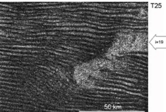
Figure 2 – Potential stabilized dunes seen at 53 N, 43 W on Titan. Aside from illuminated slopes, the landforms have similar SAR signal to surroundings.
Results: Dune-like landforms are visible at
mid-to-high latitudes in the Ta (51° N, 79° W), T18 (48° N, 352° W), T21 (40° N, 247° W), T23 (53° N, 43° W), T30 (52° N, 240° W), T50 (48° S, 342° W), T56 (59° S, 189° W), and T64 (42° N, 214° W) regions. The features have varying appearances and relationships with surrounding materials, and they all have widths of 1-2 km and spacings of 2-4 km, similar to dunes at low latitudes [7]. The average length of all 169 features is 31 km. Dark dunes in a sample low-latitude region with high-contrasting substrate have an average (all statistics are for 5x5 pixel samples) radar cross section σ0=0.04, SD=0.06 and adjacent interdunes have σ0=0.83, SD=0.31. DLLs at 53° N (Fig. 2) have σ0=0.26, SD=0.12 and nearby materials have σ0=0.19,
2224.pdf 43rd Lunar and Planetary Science Conference (2012)
SD=0.07. The mean orientations (from 0° N) of the dune-like landforms at mid-to-high northern latitudes is consistently 100°-130° and at mid-to-high southern latitudes is 25°-70°.
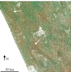
VIMS spectra for the locations containing DLLs are different from those found in dune areas (Fig. 3). Generally, DLLs are found in VIMS light pink regions, similar to other mid-latitude landforms. High-resolution T31 VIMS data over the SAR T30 DLL region reveal perhaps a slight correlation with VIMS light pink, or compositional variations not related to any visible landforms (Fig. 4).
Figure 3 – VIMS observations of DLL regions.
Figure 4 – T31 high-res VIMS overlay on T30 DLL region. Arrows indicate DLLs in upper left and middle.
Discussion: The general morphology (length,
width, spacing, height) of DLLs is similar to that of radar-dark dunes at the tropics. Additionally, the con-sistency of orientations of DLLs in each hemisphere across a variety of latitudes strengthens the interpreta-tion that these are dunes. No other landform except dunes is so broadly consistent in orientation on Titan, a factor that is related to the robustness of the global wind pattern. The mid-high latitude DLLs have orien-tations suggestive of convergence toward the equator, a pattern predicted by some atmospheric models [8].
DLLs have higher radar backscatter than that of dunes, and they have negligible contrast to surround-ings. Three main hypotheses for DLLs have emerged:
The DLLs are composed of rough or porous materials (in contrast to smooth, absorbing organic dune sands), DLLs have thin sands that allow the radar signal to penetrate through to the rough substrate, or DLLs are made of dune sands that have been stabilized by me-thane liquids or organic cements.
The first hypothesis could have been achieved by constructing DLLs with materials other than the organ-ics that make up low-latitude dunes. This material would have a higher backscatter than dune sands, which is observed; however, it is expected there would be a contrast with surrounding, nondune material. In addition, VIMS data do not strongly suggest a differ-ence between DLL materials and surroundings. The second hypothesis, that the DLLs are made of thin sands, is not borne out by VIMS data, which should see dune material of mm thickness [3].
We favor the final hypothesis, that DLLs formed of organic sands that were subsequently stabilized. Organic fluids could enter loose dune sands and there-by increase the density and thus the radar backscatter, as happens with wet sand on Earth, and thereby inhibit saltation. Methane could also carry dissolved organics and nitriles that precipitate within the dunes, creating cements and solidifying the dune forms, a process sim-ilar to the one that created the massive, dune-derived, bedrock layers of the Colorado Plateau. VIMS data at mid-high latitudes (Fig. 4), where landforms do not appear to correlate with VIMS compositions, indicate such regions may have undergone more recent and uneven coating by and diffusion of organic materials.
Stabilized dunes are created when wind, humidity, or climate patterns have changed, leading to conditions no longer favourable for the active transport of sands [9]. Relative methane humidity is thought to increase toward polar regions, especially toward the north [10]. Dunes have a decreasing dune/interdune ratio toward higher northern latitudes, perhaps a result of increased humidity [6], which may anchor sands against move-ment, and/or introduce cements, causing the dunes to have similar radar backscatter to surrounding terrains. Given the long timescales for linear dune formation and evolution (tens of thousands of years on Earth), it is likely whatever process has stabilized the mid-to-high latitude dunes has persisted for longer than a sin-gle Titan season.
References: [1] Radebaugh, J. et al. (2008) Icarus 194, 690-703. [2] Lorenz, R.D. and J. Radebaugh (2009)
Ge-ophys. Res. Lett. 36, L03202. [3] Barnes, J.W. et al (2008) Icarus 195, 400-414. [4] Radebaugh, J. et al. (2010) Geo-morphology 121, 122-132. [5] Paillou, P. et al. (2011)
EPSC/DPS, abstracts. [6] Le Gall, A. et al (2011) Icarus 213, 604-624. [7] Savage, C. (2011) Thesis, BYU. [8] Lorenz, R. D. et al. (2006) Science 312, 724-727. [9] Lancaster, N. (1995) The Geomorphology of Desert Dunes, 290 pp. [10] Aharonson, O. et al. (2009) Nature Geoscience 2, 851-854.
2224.pdf 43rd Lunar and Planetary Science Conference (2012)