HAL Id: hal-00766117
https://hal.archives-ouvertes.fr/hal-00766117
Submitted on 17 Dec 2012HAL is a multi-disciplinary open access archive for the deposit and dissemination of sci-entific research documents, whether they are pub-lished or not. The documents may come from teaching and research institutions in France or abroad, or from public or private research centers.
L’archive ouverte pluridisciplinaire HAL, est destinée au dépôt et à la diffusion de documents scientifiques de niveau recherche, publiés ou non, émanant des établissements d’enseignement et de recherche français ou étrangers, des laboratoires publics ou privés.
the context of sustainable management of Earth
resources
S. Durrieu, R. Nelson
To cite this version:
S. Durrieu, R. Nelson. Revisiting the status of space-borne lidar missions for assessing structural and biophysical forest parameters in the context of sustainable management of Earth resources. SilviLaser, Oct 2011, Hobart, Australia. 12 p. �hal-00766117�
Revisiting the status of space-borne lidar missions for assessing structural and biophysical forest parameters in the context of sustainable management of Earth resources
S. Durrieu1 and R. Nelson2
1
Cemagref, UMR TETIS, 500, rue J.F. Breton BP 5095, 34196 Montpellier Cedex 5, France, sylvie.durrieu@teledetection.fr
2
Code 614.4, Biospheric Sciences Branch, NASA/GSFC, Greenbelt, MD 20771 USA, ross.f.nelson@nasa.gov
Abstract:
Assessing forest aboveground biomass at global scale is crucial to address the challenge of sustainable management of forest resources and to strengthen forest-based climate change mitigation. To achieve this goal relying on spaceborne lidar missions is acknowledged to be a highly relevant solution. However, if this is taken as a given from the measurement point of view, the premise that spaceborne observation is the most suitable solution to provide information for sustainable management of forest resources is worth discussing. In this paper we suggest to take a fresh look at measurement processes designed to support the monitoring of Earth resources. We discuss the sustainability of Earth observation from space considering (1) issues that call into question the assumption that Earth-orbiting platform will always be available to the civilian remote sensing community and (2) issues concerning environmental impacts of space activity on the Earth. This leads us to suggest some actions that could help to design future observation systems in a more sustainable way in order to strengthen the capacity of measurement processes to meet their stated functional goal, i.e. sustainable management of forest resources.
Keywords: space remote sensing, lidar, forest, biomass, sustainability, sustainable management
1.
Introduction
Robust systems for measuring, assessing, and reporting key forest parameters, e.g. biomass, carbon, are needed to define adequate management practices and policies to address the challenge of sustainable management of forest resources and to strengthen forest-based climate change mitigation (Baker et al., 2010; Bernier and Schoene, 2009; Liu and Han, 2009; Thürig and Kaufmann, 2010). A spaceborne lidar that acquires samples of vegetation height and canopy closure measurements, used alone or in combination with optical and radar imagery, appears as the most promising way to estimate aboveground forest biomass and carbon at a global scale. Indeed such a solution combines beneficial measurement properties of spaceborne remote sensing and lidar technology. Spaceborne remote sensing greatly facilitates the acquisition of worldwide information consistent in both space and time. This information, supported by ground observations, is considered as the key to effective monitoring (DeFries et al., 2007; Fuller, 2006; Kleinn, 2002). The utility of lidar with respect to forest structure measurements and biomass estimation has been widely demonstrated (Lim et al., 2003; Næsset, 2004; Wulder et al., 2008) even in closed-canopy tropical areas supporting high biomass forests (>200 Mg ha-1) (Kellner et al., 2009; Lefsky et al., 2005) where optical vegetation indices and volumetric radar measurements typically saturate (Castro et al., 2003). This led scientists to design and propose to space agencies, so far unsuccessfully, space lidar missions with forest measurement and monitoring as the primary scientific objectives (e.g. VCL, LVTM, Carbon-3D, DESDynI-Lidar, LEAF).
ICESat (2003-2009) was the first spaceborne lidar system designed to measure terrestrial surfaces. Despite the ice-centric design, several studies used ICESat/GLAS data to estimate forest structure and biomass at regional and global scales (Boudreau et al., 2008; Helmer et al., 2009; Lefsky et al., 2005; 2007; Lefsky, 2010; Nelson et al., 2009). However Nelson (2010) outlines some of the limitations associated with GLAS-based biomass estimates. ICESat-2, scheduled for launch in 2016, also includes among its secondary scientific objectives large-scale biomass and biomass change estimations (Nelson et al., 2010). But some simulations showed that the ground signal is expected to be lost at canopy closures exceeding ~95%, thus making calculation of canopy height impossible.
Even if the relevance of a spaceborne lidar mission designed to monitor global forest biomass is taken as a given from the measurement point of view, the premise that spaceborne observation is the most suitable solution to provide information for sustainable management of global forest resources should be discussed. Indeed the sustainability of Earth observation from space is not as obvious as it might seem.
The paper is structured to take a fresh look at measurement processes designed to support the monitoring of Earth resources and to promote discussion about the place of remote sensing within the context of sustainable management of these resources. Sustainability is defined as the capacity to endure and sustainable development as “development that meets the needs of the present without compromising the ability of future generations to meet their own needs” (UN, 1987). Section 2 examines issues that call into question the basic assumption that Earth-orbiting platforms will always be available to the civilian remote sensing community. Section 3 focuses on the environmental impacts of space activity on the Earth and reports how these impacts affect sustainability. Section 4 suggests possible actions that might be taken to mitigate impacts associated with space missions by depending more on existing infrastructure to gather global observations.
2.
Uncertainties about the future of Earth observation from space
2.1 Historical context, current state and future tendency of space activity
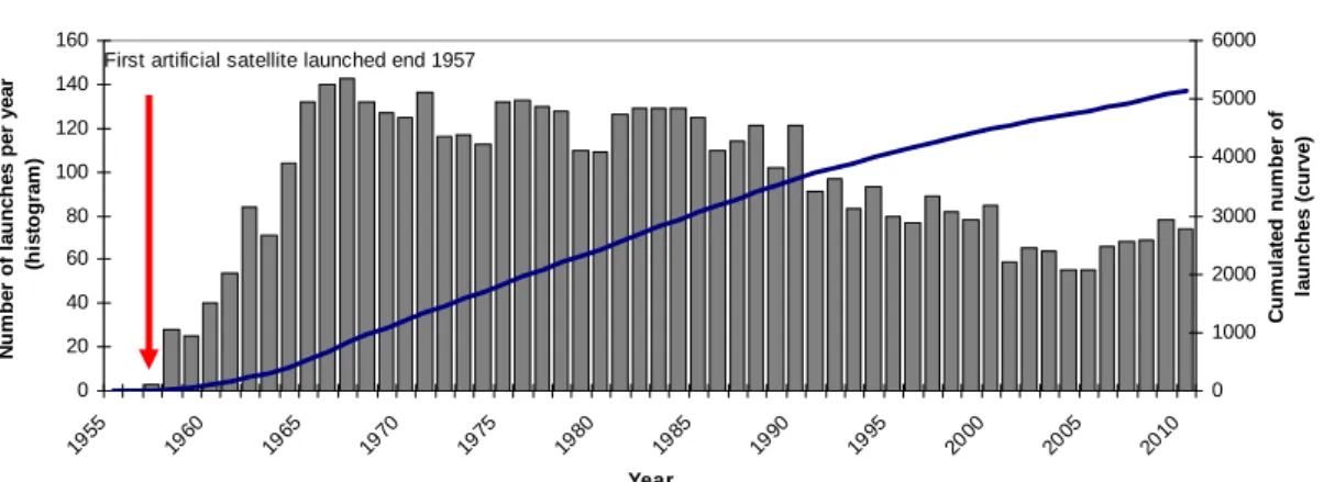
The development of space began in 1957 with the launch of Sputnik, the first artificial Earth-orbiting satellite. The total number of launches since 1957 exceeded 5000 during year 2009 (Figure 1) and the mean annual number of launches over the 10 past years has been slightly higher than 65 (McDowell, 2011).
The development of space has long been driven by the political and military aspirations of the two main actors of this sector, USA and Russia. With the end of the cold war in 1991, the rise of commercial interests in some applications – e.g. telecommunication and Earth observation - and the emergence of new space powers have led to a drastic transformation of the space sector. There are currently about 1000 active satellites, operated by 41 countries and several international consortiums (UCS, 2011). Figure 2 shows the distribution of satellites according to orbit classes and scientific/commercial disciplines. Of the 135 active Earth observation satellites, 120 are on LEO. The profound changes in the space sector led to a reduction in public investments that have weakened this sector (Pasco, 2003), at least as measured by launch activity. However, according to Pasco (2003), projects like the European Global Monitoring for Environment and Security (GMES) that bring space to society rather than the converse, could bolster this sector. Furthermore the development of satellite constellations and of micro-satellite technology, making space technology affordable for developing countries (Woellert et al., 2011), is assumed to result in an ongoing increase in the number of active satellites.
Annual and cumulated number of launches from 1957 to 2010 0 20 40 60 80 100 120 140 160 195 5 196 0 196 5 197 0 197 5 198 0 198 5 199 0 199 5 200 0 200 5 201 0 Year N u mb e r o f la u n c h e s p e r y e a r (h is to g ra m ) 0 1000 2000 3000 4000 5000 6000 C u m u la te d num be r o f la u n ch es ( c u rve )
First artificial satellite launched end 1957
Figure 1: Evolution of the number of launches since 1957 estimated using the McDowell’s data base (McDowell, 2011). The histogram represents the number of annual launches (Y left axis) while the curve
represents the cumulated number of launches since the launch of Sputnik (Y right axis).
(a) Distribution of active satellites according to orbit classes
Elliptical Orbit 4% Medium Earth Orbit 7% Geosynchr Orbit 41% Low Earth Orbit 48%
(b) Distribution of active satellites
according to the discipline in which the satellite is used
Communication 59% Astrophysics 2% Navigation 8% Earth observation 14% Others 11% Meteorology 1% Technology Development 5%
Figure 2: a) Distribution of the 957 current active satellites according to orbit class: Low Earth Orbit (LEO) refers to orbit with altitudes between 80 and 1,700 km; Medium Earth Orbit (MEO) to orbits between 1700 and 35,700 km ; Geosynchronous Orbits (GEO) are around 35,700 km; Elliptical orbits
have a non constant altitude. b) Distribution of active satellites according to their use. These figures result from analysis of the UCS database (UCS, 2011)
2.2 Space junk and its consequence on future activity
Space development has resulted in an increase in the amount of space debris, i.e.non-functional satellites, upper stages of launchers, functional debris (bolts, belts,…) and fragments originating from collisions, launcher upper stages, and spacecraft explosions, up to a point where orbital debris is currently a threat to spacecraft health and safety (Newman, 2010). The current number of catalogued objects, i.e. objects larger than 5 to 10 cm in Low Earth Orbit (LEO) and 30 to 100 cm at geostationary altitudes, that are tracked by the US Space Surveillance Network is higher than 13 000 and is increasing by several hundreds per year (Newman, 2010). Estimations of non-catalogued objects vary depending on the source; according to the CNES, there would be ~200 000 objects between 1 and 10 cm and ~35 millions between 0.1 and 1 cm (CNES, 2011). The larger part of orbital debris population, ~40% of the total debris larger than 1 mm in size, resides in LEO (CNES, 2011). LEO space debris mitigation is a critical issue for space activity
sustainability. Up to now 4 accidental collisions have been identified (CNES, 2011) and 3 other are suspected (Flohrer et al., 2009). To prevent collisions with catalogued debris, alert systems for high-risk conjunction events have been developed by space agencies, permitting them to implement avoidance manoeuvres when necessary (Flohrer et al., 2009; Newman, 2010). Non-catalogued debris ranging from 1 to 10 cm can also generate very significant damage but the collision risk can only be studied statistically through analysis of impacts on dedicated experimental platforms or on launchers and large space debris that returns to Earth. Table 1 reports collision probabilities. A simulation model of LEO predicted that, even with no future launches, the critical point where the population of artificial space debris would grow at a faster rate than the natural decay rate could be reached in about 50 years (Bradley and Wein, 2009). The possibility that LEO could be made inaccessible for thousands of years by a chain reaction of debris collisions is underlined by several authors (Bradley and Wein, 2009; Weeden, 2011; Williamson, 2004).
Table 1 : Probability of collision over one year according to debris size for a satellite with a 20m2 surface area at an orbital altitude similar to SPOT, i.e., 825 km (CNES, 2011).
Debris size > 0.1 mm > 1mm > 1cm > 10 cm
Probability of collision over 1 year 1 0.5 3x10⁻³ 2x10⁻⁴
3.
Space activity a source of pollution for the Earth environment
The risks linked to space activities that are most frequently discussed in the literature are on-orbit collision risks, which threaten the commercial exploitation of space, and risks to people on the ground during natural re-entries of debris, which is currently estimated to be lower than the risk associated with meteorite impact (CNES, 2011).
We discuss now a more seldom addressed topic: space activity as a source of pollution for the Earth environment. We focus on environmental impacts with respect to launch, life on-orbit, and end-of-life.
3.1 Launch and Orbit Insertion
The launch stage is responsible for two main kinds of pollution. The first one is the immediate return-to-Earth of the accelerator stage that separates from the launcher after fuel exhaustion and that is not systematically salvaged and seldom reused. The second one is related to propulsion system functioning. Most spacecraft depend on a rocket engine for propulsion. Approximate emissions for the main propellant types are given in table 2 and include, as for aircraft, greenhouse gases that directly add to radiative forcing and warming, as CO2 and water
vapour, and compounds that indirectly contribute to production or loss of green house gases such as ozone and methane (Ross et al., 2009). The amount of emitted gases is trivial compared to other sources. For example annual CO2 emissions are estimated to be several kilotons
compared to emissions of several hundred kilotons from aircraft, which is in turn between 2 an 3 % of the total emissions from all activities (Leary, 1999; Ross et al., 2009; Wilkerson et al., 2010). However, besides transient changes near the launch site that affect the lowermost troposphere, emissions may cause global lasting changes in the stratosphere where atmospheric circulation is characterized by an horizontal mixing of gases occurring faster than the vertical mixing (Ross et al., 2009).
Table 2: Approximate emissions for the four main propellant types (one solid and three liquid) given as mass fraction for each propellant. The total mass fraction exceeds unity because of the assumption that air
mixed into the plume oxidizes CO and H2 (source : Ross et al., 2011).
Propellant type N2 CO2+CO H2O + H2 ClOx, HOx,
NOx HCl Alumina soot Solid (NH4ClO4/Al) 0.08 0.27 0.48 0.1 0.15 0.33 Cryogenic (LOX/H2O) - - 1.24 0.02 - - Kerosene (LOX/RP-1) - 0.88 0.30 0.02 - 0.05
Hypergolic (UDMH/N2O4) 0.29 0.63 0.25 0.02 - Trace
Local impacts of launch events are studied at the French Guiana Space Center (CSG). At each launch, 600 measurements are taken at several distances from the launch zone and include concentration measurements of hydrochloric acid, nitrogen dioxide, hydrazine and alumina. Analyses show that impacts are mainly localized nearby the launch area (<2.3 km) where high levels of HCl and Alumina concentrations are registered (see Table 3). Impacts were found to be low at intermediate distance (up to 8 km) and non-significant beyond. Impacts on water quality, vegetation and fauna are also monitored; up to now no significant negative impact has been noticed (CSG, 2011)
Table 3: Example of maximal concentrations of HCL and Alumina measured during an Ariane 5 launch (flight 185, 24-08-2008). Near field refers to a distance from launch site <2,4 km and far field from 2,4 to
24 km. Measures are compared to human toxicity thresholds (source: http://www.ggm.drire.gouv.fr/)
Maximal near field
concentration (mg/m2)
Maximal far field concentration (mg/m2)
Toxic limits defined for humans
Ion CL- (HCL)
5136.2 89.84
(measured at 4.350 Km )
90 mg/m3: irreversible effect after 30 mn exposure
700 mg/m3: lethal effect after 30 mn exposure
Alumina 94.68 3.49 Acceptable mean exposure value for
workers = 10 mg/m3 during 8h, 5 days/week
Part of the rocket combustion products are injected directly into the middle and upper stratosphere. The stratosphere is characterized by a low concentration in water vapour and includes the major part of the ozone layer. While climate response seems to be independent of where CO2 emissions occur (http://www.co2offsetresearch.org/aviation/DirectEmissions.html),
the increase in forcing due to water vapour emitted in the stratosphere is significant compared to a similar water vapour emission in troposphere (Leary, 1999). Furthermore emitted compounds contribute to ozone depletion in several ways. Some of them are highly reactive radicals - NOx,HOx,ClOx - directly involved into catalytic cycles leading to an increase in the ozone
removal rate while others contribute to increase the tropospheric radical reservoirs. As for emitted water vapour, it is the source gas for HOx radicals and contributes to the formation of
ice particles also responsible for ozone loss. Ozone loss from water vapour is highly nonlinear and difficult to predict (Ross et al., 2009). The ozone layer is protected by international agreements that limit the production of substances causing ozone depletion (i.e. the Montreal Protocol on Substances That Deplete the Ozone Layer) and Ross et al. (2009) demonstrated that if the Space Shuttle had met its original goal of weekly launches it would have been, alone, responsible for an ozone loss close to a quantity assumed by these authors to be the upper limit acceptable by the stratospheric protection community, even considering the unique value of space activity.
3.2 On-orbit life
Several compounds are also released in the upper atmospheric layers during the on-orbit lifetime of LEO satellites. First, the atmospheric drag in LEO causes orbital decay and the platform has to be repositioned occasionally. This is usually done using nozzle-based systems, most of them employing hydrazine as monopropellant. The highly exothermic catalytic decomposition of hydrazine produces jet of hot gas and thus thrust. The expulsed gas is composed of ammonia (NH3), dihydrogen (H2) and nitrogen (N2). Second, the presence of a
diffuse atmosphere causes wearing effects on satellite platforms. Atomic oxygen, the predominant component in LEO atmosphere, is responsible for the degradation of thermal, mechanical, and optical properties of exposed materials (Liu et al., 2010). It interacts with hydrocarbon polymers (e.g., Kapton, Teflon, Mylar…) that are used to thermally insulate/protect parts of the satellite (Banks et al., 2011); important Kapton mass losses have already been observed attesting to the fact that volatile oxidation products have been released into the LEO domain.
3.3 End-of-life
The on-orbit lifetime of non-active satellites and other debris depends on the presence and density of the terrestrial atmosphere at a given altitude. Atmospheric drag slows down orbiting objects, making them return to Earth. During atmospheric re-entry objects are intensively heated and part of the material is sublimated. However large debris pieces can return to Earth. Most of them (> 70 %) will impact bodies of water (Johnson, 1999). As an example, during the Mir controlled re-entry, while the initial mass in orbit was around 140 tons, 30 tons of debris fell into the Pacifique Ocean.
Another environmental threat from space activities comes from the use of nuclear reactors. Such reactors generate very high electrical power levels. Their use on military satellites drives the increased spatial resolving power of on-board radars and does away with the need for large solar sails. Decreasing the satellite cross-sectional area is paramount, making localization more difficult and lowering risks of hostile actions from anti-satellite systems (ASAT) (Finn, 1984). Nuclear generators also enabled missions such as Apollo Lunar surface experiments and interplanetary missions requiring to go where the sunlight intensity and the temperatures are low and the radiation belts very severe (Bennett, 2006). Since 1961, the USA and the former Soviet Union used nuclear energy to provide power for respectively 24 and 37 space systems (Bennett, 2006). Several nuclear-powered space vehicles are known to have fallen to Earth and were responsible for the release of radioactive elements either in atmosphere or on the Earth’s surface (Finn, 1984), e.g. Cosmos-954 in 1978 or Transit satellite in 1964.
3.4 Impact of space activities on the Earth system
As a consequence of space activity in general and of LEO missions more specifically, debris, particles, and various chemical compounds are released within all the layers of the atmosphere, from the troposphere to the Exosphere (up to 10000 km). A portion of these elements falls back onto the Earth surface.
Our current atmosphere is the result of a long, progressive, and continuing evolution. The ocean-atmosphere envelope demonstrates non-linear dynamics, making relatively rapid changes in climatic patterns a likely feature of the future Earth. Forcing on the parameters that affect change (e.g., the greenhouse effect) may increase the speed and unpredictability of such changes (Adams, 2006). Historical and ongoing examples of the negative impacts associated with anthropogenically-induced atmospheric changes include acid rain, ozone depletion, and climate change. A unique characteristic of space activity is that it is the only human activity that releases elements in the upper atmospheric layers where concentrations of natural compounds are low. Consequently even the introduction of elements in small quantities can greatly affect atmospheric composition and chemistry; witness the effects of reactive radicals on the ozone
cycle (Ross et al., 2009). Impacts of space activity on complex processes occurring in upper atmospheric layers have been little studied until now and there is a clearly a lack of knowledge on the potential consequences of space activity on atmosphere composition and on radiative transfer. Environmental impacts and the amount of radioactivity that would reach the Earth surface in the case of the disintegration of a reactor core in the upper atmosphere during an accidental re-entry are also unknown (Finn, 1984). Based on current knowledge we can only say that, due to its special features, space activity brings with it a pollution capacity difficult to assess but presenting potentially high risks. Furthermore we only discussed in this section environmental impacts from launch to satellite end of life. With many products a large share of environmental impacts is not in the use of the product but in its production and transportation (Guinée et al., 2011). Therefore impacts associated with launcher, platform and instrument manufacturing and those impacts related to the functioning of ground segments should be also examined.
4.
Toward sustainable Earth observation systems for forest monitoring
This last section discusses sustainable Earth observation networks or systems, i.e. systems involving measurement processes that are compatible with sustainability principles. In a first sub-section we will focus on elements concerning space activity in general while in a second sub-section we will consider actions that could be implemented when designing systems based on lidar technology for forest structure measurement.
4.1 Toward sustainable space activity
Two main problems hamper the development of space activity in a sustainable way: space debris, which threaten the activity itself, and potential negative impacts on both space and Earth environments. According to Willianson (2003) ethical and code policy for space should include protection of Earth orbit as a commercial and scientific resource by formalising debris mitigation measures. Space agencies, e.g., CNES, ESA, NASA, have already developed guidelines to mitigate space debris. At an international level, the United Nations Committee for the Peaceful Uses of Outer Space (UNCOPUOS) has already taken interest in space debris and in the use of nuclear energy in space. But, as a consultative body, it has no legislation power (Williamson, 2003; Williamson, 2004). Bradley and Wein (2009) demonstrated that achieving full compliance with the 25-year spacecraft deorbiting guidelines could maintain the lifetime risk from space debris at a sustainable level. However Taleb and al. (2009), who analysed common errors in risk management strategies, maintain that it is more efficient to reduce the impact of threat we cannot control rather than to focus on statistical predictions of low-probability high impact events. Following such advice would involve 1) doing all that is possible to reduce space junk by developing, for example, orbital debris removal operations as proposed by Weeden (2011), 2) making best efforts to mitigate future launch pollution and debris, keeping space as pristine as practically possible, and 3) thinking about alternatives to spaceborne solutions in case LEO becomes inaccessible.
We consider what could be done to protect the Earth environment from damages related to space activity, specifically addressing issues related to risk management and recycling. This discussion may require the reader to adopt non-traditional points of view. Concerning risk management, it would be necessary to shift from minimizing type-I error, i.e., rejecting the null hypothesis (or status-quo) when it is true, to minimizing type-II error, i.e., accepting the null hypothesis when it is false (Bergen et al., 2001). Usual scientific approaches tend to minimize type-I errors as a means to achieve high levels of confidence in the decision to throw out a null hypothesis and accept that some sort of change has occurred or that a “new” condition exists. When applied to environmental management, minimizing type I error means that we need to be near-certain that environmental or ecological damage has occurred (due to space activity in our
case) before we would accept the alternative hypothesis (Bergen et al., 2001). The net effect of relying on such an approach to determine action is that the damage would be done by the time the test tells us to act. With respect to prevention, mitigation, or remediation, this course of action is counterproductive.
Concerning recycling, it is worth noticing that, for the space activity sector, any object (satellite, piece of launcher…) is considered to be recycled when it has been destroyed during its re-entry in atmosphere or has fallen back on the earth surface. This is far from the notion of recycling in the context of sustainable development. The Earth’s capacity to sequester human waste is limited (Adams, 2006) and recycling aims to reduce waste. Furthermore part of so-called “recycled” spacecraft is pollutants emitted into atmosphere or on the ground. To better grasp this issue research is needed to assess the behaviour of material released into the upper atmospheric layers by space activity. In addition to site impact studies realized on industrial sites, life cycle assessment (LCA) could be used to help quantify environmental impacts of Earth observation systems and to identity critical stages where these impacts might be mitigated. Environmental LCA are standardized (ISO 14040 and 14044) multi-criteria, quantitative approaches that permit to assess environmental impacts associated with all the stages of a product's life, from-cradle-to-grave (Guinée et al., 2011).
4.2 Designing systems based on lidar technology for forest structure measurement Acquiring consistent and extensive spatial data for statistical reporting and mapping of forest resource is a technological issue required to address the challenge of sustainable management of forests. Integration of spaceborne and/or airborne lidar data with ground-based information is now widely advocated. However small steps, including some very simple actions, could help to optimize the way the several measurement processes are designed and used to provide information on forest structure and biomass.
Due to geopolitical constraints, satellite-based solutions seem to be currently the only way to acquire data globally. However, when designing space missions, actions could be done to make them more compatible with sustainability principles. A first step is to think about a mission as a contributor to space activity as a whole and therefore as a contributor to the problems discussed in this paper. Priority might be given to missions with long lifetimes in order to reduce the number of launches, space debris, and to lessen environmental damage. Priority might also be given to international missions in order to reduce mission duplication, e.g., multiple L-band radars, multiple 30m Landsat-like clones. Consideration should also be given to the use of existing space infrastructure. For instance, the International Space Station could host a lidar package to make measurements of the Earth’s forests south of 51.6ºN over the life of the ISS (current expectation ~10 year).
The relative contribution of each kind of measurement method, i.e. spaceborne, airborne acquisitions and field data, could be also cautiously compared considering a cost/benefit balance including economical, environmental, and societal aspects. For example, from a strictly economical point of view, space remote sensing is considered cost effective for end-users, especially given that much of the data are freely available. But this statement does not take into account all national funding invested into space activity. Consideration of the full compliment of expenditures might indicate that airborne solutions are more viable. Meanwhile, field data are often described as being costly and time consuming (Thuresson, 2002). But field campaigns, which are essential to develop models to assess forest parameters (calibration/validation steps), also provide information that cannot be acquired by other means, e.g. assessment of local biodiversity. Environmental impacts of complementary measurement processes could be compared using LCA in order to define the best way to combine them to reduce environmental impacts.
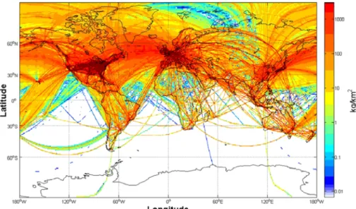
To end, we are going to suggest alternative solutions to current systems that might be worth exploring in the future. Traditional lidar acquisitions with topographic airborne systems are cost prohibitive, in particular for developing countries. Developing low cost, light systems designed specifically for forest resource assessment, e.g. PALS (Nelson et al., 2003) or LAUVAC systems (Allouis et al., 2010; Cuesta et al., 2010), might be one way to provide to developing countries a capacity to achieve accurate forest inventories. Thinking outside the box, can we embed light lidar systems on commercial jet aircraft? This could diminish both cost and environmental impacts. Figure 4 gives an idea of the distribution of the main commercial aircraft lines over the world and we can see that all terrestrial areas, except Antarctic, are covered, albeit at greatly varying flight line densities. Handling such data sets acquired on these commercial routes would certainly be challenging from a statistical standpoint.
Figure 4: This figure presented in Wilkerson (2010) shows the total CO2-C (kg/m2) emitted from commercial aviation for the year 2006 and indirectly gives an idea of commercial traffic density
worldwide
5.
Conclusion
There is a consensus to consider remote sensing from space as a technology of high value to provide worldwide measurements consistent in time and space. In this paper we proposed to change our view on measurements and to shift from a traditional view where measurement quality is assessed through metrology properties alone and where measurement processes are designed taking into account mainly economical and technological constraints to a more holistic view considering interactions between remote sensing observation systems and the Earth environment. This led us to suggest that regional and global forest measurements should be acquired in accordance with sustainability principles and with the willingness to reduce environmental impacts. Such goals strengthen the capacity of measurement processes to meet their stated functional goal, i.e., sustainable management of Earth resources. Currently, space remote sensing is mainly driven by economic and technical constraints, and is far from sustainability; there are notable uncertainties concerning the future of LEO accessibility and on the effects of pollution concomitant with space activity. We suggest some actions that could help to design future observation systems, in particular for measuring forest structure, in a more sustainable way. To that end, studies that cautiously assess environmental impacts of the several currently available measurement approaches should be considered.
References
Adams, 2006. The Future of Sustainability: Re-thinking Environment and Development in the Twenty-first Century, IUCN, Gland, Switzerland, 18 p., http://cmsdata.iucn.org/downloads/iucn_future_of_sustanability.pdf, accessed May 2011
Allouis, T., Durrieu, S., Cuesta, J., Chazette, P., Flamant, P.H. and Couteron, P., 2010. Assessment of tree and crown heights of a maritime pine forest at plot level using a fullwaveform ultraviolet lidar prototype. 2010 30th IEEE International Geoscience and Remote Sensing Symposium, IGARSS 2010, Honolulu, HI, pp. 1382-1385.
Baker, D.J., Richards, G., Grainger, A., Gonzalez, P., Brown, S., DeFries, R., Held, A., Kellndorfer, J., Ndunda, P., Ojima, D., Skrovseth, P.-E., Souza Jr, C. and Stolle, F., 2010. Achieving forest carbon information with higher certainty: A five-part plan. Environmental Science & Policy, 13(3): 249-260.
Banks, B.A., Backus, J.A., Manno, M.V., Waters, D.L., Cameron, K.C. and de Groh, K.K., 2011. Prediction of Atomic Oxygen Erosion Yield for Spacecraft Polymers. Journal of Spacecraft and Rockets, 48(1): 14-22.
Bennett, G.L., 2006. Space nuclear power: Opening the final frontier, Collection of Technical Papers - 4th International Energy Conversion Engineering Conference. 4th International Energy Conversion Engineering Conference, San Diego, CA, pp. 1433-1449.
Bergen, S.D., Bolton, S.M. and L. Fridley, J., 2001. Design principles for ecological engineering. Ecological Engineering, 18(2): 201-210.
Bernier, P. and Schoene, D., 2009. Adapting forests and their management to climate change: An overview. Unasylva, 60(231-232): 5-11.
Boudreau, J., Nelson, R.F., Margolis, H.A., Beaudoin, A., Guindon, L. and Kimes, D.S., 2008. Regional aboveground forest biomass using airborne and spaceborne LiDAR in Québec. Remote Sensing of Environment, 112(10): 3876-3890.
Bradley, A.M. and Wein, L.M., 2009. Space debris: Assessing risk and responsibility. Advances in Space Research, 43(9): 1372-1390.
Castro, K.L., Sanchez-Azofeifa, G.A. and Rivard, B., 2003. Monitoring secondary tropical forests using space-borne data: Implications for Central America. International Journal of Remote Sensing, 24(9): 1853-1894.
CNES, 2011. http://debris-spatiaux.cnes.fr/english/index_eng.html, accessed May 2011.
CSG, 2011. http://www.cnes-csg.fr/web/CNES-CSG-en/5678-weather-and-risk-management.php, accessed May 2011.
Cuesta, J., Chazette, P., Allouis, T., Flamant, P.H., Durrieu, S., Sanak, J., Genau, P., Guyon, D., Loustau, D. and Flamant, C., 2010. Observing the Forest Canopy with a New Ultra-Violet Compact Airborne Lidar. Sensors, 10(8): 7386-7403.
DeFries, R., Achard, F., Brown, S., Herold, M., Murdiyarso, D., Schlamadinger, B. and de Souza Jr, C., 2007. Earth observations for estimating greenhouse gas emissions from deforestation in developing countries. Environmental Science and Policy, 10(4): 385-394.
Finn, D.P., 1984. Nuclear satellites: why has the government downplayed their risks? Environment, 26(1): 14-20, 39.
Flohrer, T., Krag, H. and Klinkrad, H., 2009. ESA's process for the identification and assessment of high-risk conjunction events. Advances in Space Research, 44(3): 355-363.
Fuller, D.O., 2006. Tropical forest monitoring and remote sensing: A new era of transparency in forest governance? Singapore Journal of Tropical Geography, 27(1): 15-29.
Guinée, J.B., Heijungs, R., Huppes, G., Zamagni, A., Masoni, P., Buonamici, R., Ekvall, T. and Rydberg, T., 2011. Life cycle assessment: Past, present, and future. Environmental Science and Technology, 45(1): 90-96.
Helmer, E.H., Lefsky, M.A. and Roberts, D.A., 2009. Biomass accumulation rates of Amazonian secondary forest and biomass of old-growth forests from Landsat time series and the Geoscience Laser Altimeter System. Journal of Applied Remote Sensing, 3(1).
Johnson, N.L., 1999. The reentry of large orbital debris. Science and Technology Series, 96: 285-293.
Kellner, J.R., Clark, D.B. and Hofton, M.A., 2009. Canopy height and ground elevation in a mixed-land-use lowland Neotropical rain forest landscape. Ecology, 90(11): 3274. Kleinn, C., 2002. New technologies and methodologies for national forest inventories.
Unasylva, 53(210): 10-15.
Leary, N., 1999. Aviation and the Global Atmosphere-A Special Report of IPCC Working Groups I and III, IPCC Symposium, Tokyo, Japan, July 1, 1999, pp. p 7
Lefsky, M.A., 2010. A global forest canopy height map from the moderate resolution imaging spectroradiometer and the geoscience laser altimeter system. Geophysical Research Letters, 37(15).
Lefsky, M.A., Harding, D.J., Keller, M., Cohen, W.B., Carabajal, C.C., Del Bom Espirito-Santo, F., Hunter, M.O. and de Oliveira Jr, R., 2005. Estimates of forest canopy height and aboveground biomass using ICESat. Geophysical Research Letters, 32(22): 1-4. Lefsky, M.A., Keller, M., Pang, Y., de Camargo, P.B. and Hunter, M.O., 2007. Revised method
for forest canopy height estimation from Geoscience Laser Altimeter System waveforms. Journal of Applied Remote Sensing, 1.
Lim, K., Treitz, P., Wulder, M., St-Onge, B. and Flood, M., 2003. LiDAR remote sensing of forest structure. Progress in Physical Geography, 27(1): 88-106.
Liu, G. and Han, S., 2009. Long-term forest management and timely transfer of carbon into wood products help reduce atmospheric carbon. Ecological Modelling, 220(13-14): 1719-1723.
Liu, Y., Liu, X., Li, G. and Li, T., 2010. Numerical investigation on atomic oxygen undercutting of the protective polymer film using Monte Carlo approach. Applied Surface Science, 256(20): 6096-6106.
McDowell, J., 2011. Jonathan’s space report, N°640, April 2011, http://www.planet4589.org/, accessed 28 April 2011.
Næsset, E., 2004. Practical large-scale forest stand inventory using small-footprint airborne scanning laser. Scandinavian Journal of Forest Research, 19: 164-179.
Nelson, R., Parker, G., Hom, M., 2003, A portable airborne laser system for forest inventory, Photogrammetric Engineering and Remote Sensing, 69 (3), pp. 267-273
Nelson, R., 2010. Model effects on GLAS-based regional estimates of forest biomass and carbon. International Journal of Remote Sensing, 31(5): 1359-1372.
Nelson, R., Boudreau, J., Gregoire, T.G., Margolis, H., Naesset, E., Gobakken, T. and Stahl, G., 2009. Estimating Quebec provincial forest resources using ICESat/GLAS. Canadian Journal of Forest Research-Revue Canadienne De Recherche Forestiere, 39(4): 862-881.
Nelson, R., Neuenschwander, A., Ranson, K.J. and Cook, B., 2010. Current Characteristics of Two Space Lidars: ICESat-2 and DESDynI-Lidar, Silvilaser 2010, Freiburg, Germany, pp. 14-17.
Newman, L.K., 2010. The NASA robotic conjunction assessment process: Overview and operational experiences. Acta Astronautica, 66(7-8): 1253-1261.
Pasco, X., 2003. A new role for a new millennium? The changing nature of space activities. Space Policy, 19(1): 15-22.
Ross, M., Toohey, D., Peinemann, M. and Ross, P., 2009. Limits on the space launch market related to stratospheric ozone depletion. Astropolitics, 7(1): 50-82.
Taleb, N.N., Goldstein, D.G. and Spitznagel, M.W., 2009. The Six Mistakes Executives Make in Risk Management (October, pg 81, 2009). Harvard Business Review, 87(12): 123-128.
Thuresson, T., 2002. Value of low-intensity field sampling in national forest inventories. Unasylva, 53(210): 19-23.
Thürig, E. and Kaufmann, E., 2010. Increasing carbon sinks through forest management: a model-based comparison for Switzerland with its Eastern Plateau and Eastern Alps. European Journal of Forest Research: 1-10.
UCS, 2011. Union of Concerned Scientists Satellite Database, Based on data from 1-31-11 database, http://www.ucsusa.org/, accessed 28 April 2011.
UN, 1987. Report of the World Commission on Environment and Development: Our Common Future, UN Documents- Annex to document A/42/427- Chap.2, accessed 31 May 2011. Weeden, B., 2011. Overview of the legal and policy challenges of orbital debris removal. Space
Policy, In Press, Corrected Proof.
Wilkerson, J.T., Jacobson, M.Z., Malwitz, A., Balasubramanian, S., Wayson, R., Fleming, G., Naiman, A.D. and Lele, S.K., 2010. Analysis of emission data from global commercial aviation: 2004 and 2006. Atmospheric Chemistry and Physics, 10(13): 6391-6408. Williamson, M., 2003. Space ethics and protection of the space environment. Space Policy,
19(1): 47-52.
Williamson, M., 2004. Protection of the space environment: The first small steps. Advances in Space Research, 34(11): 2338-2343.
Woellert, K., Ehrenfreund, P., Ricco, A.J. and Hertzfeld, H., 2011. Cubesats: Cost-effective science and technology platforms for emerging and developing nations. Advances in Space Research, 47(4): 663-684.
Wulder, M.A., White, J.C., Fournier, R.A., Luther, J.E. and Magnussen, S., 2008. Spatially Explicit Large Area Biomass Estimation: Three Approaches Using Forest Inventory and Remotely Sensed Imagery in a GIS Sensors, 8(1): 529-560.