Counting on the Unexpected: Aim´e Civiale’s Mountain
Photography
Jan von Brevern
Swiss Federal Institute of Technology (ETH) Zurich
Argument
Aim´e Civiale’s attempt at a complete photographic coverage of the High Alps seems to be a peculiar project at first sight. Carried out between 1859 and 1868, this was the earliest systematic attempt to introduce photography as a medium for studying the earth sciences. But as precise and determined as Civiale’s approach appears, it was still quite unclear at the time how exactly photography could be useful in geology. This paper asks where the great confidence in the new medium in regard to mountain representations came from. The answer is not an easy one, as sources on Civiale’s project are scarce. To make things even more difficult, the confidence in photography in the earth sciences during that time seems to have been based more on hope than on actual results. It is difficult to extract hope from written sources, let alone from images. I argue that this confidence was not so much based on photography’s classic attributes of exactness or objectivity, but on its promise to produce unexpected results. Therefore this argument will inevitably have speculative elements. Thus, this paper can also be understood as an attempt to deal with a specific historiographical problem that regularly occurs when writing about images.
When observers apply a new instrument to the study of nature, what they have hoped for is of little importance, compared to the series of discoveries that results from the use of the instrument. In this area it is the unexpected that should be particularly counted on.
Franc¸ois Arago, introducing the daguerreotype in 1839 (Arago 1839, 264)
New Images for the Earth Sciences
Nothing seemed to alarm earth scientists in the mid-nineteenth century as much as the threat of chance or contingency. When Carl Ritter in 1850 presented a paper to the Royal Academy of Sciences in Berlin, he confessed to feeling uncanny and confused whenever he looked at the “wild exterior” of a terrestrial globe, “as if torn apart by blind natural force.” But encouraged by recent findings in fields such as physics, botany, or crystallography, which had discovered regularities even on the smallest scales, Ritter was not willing to surrender the surface of the earth to an “accidental, system- and
meaningless, chaotic neptunian and plutonian dictatorship.” Quite the contrary, he was sure that progress in science and history would finally unveil the spatial regularity of nature. Ritter argued that the random appearance of the earth’s crust was in fact deceptive, due only to the “weak images” with which the scientists had been working so far (Ritter 1852, 206–210).
What is a weak image? Even though Ritter uses the expression “weak” several times when talking about representations of the earth (schwache Lineamente, schwache
Repr¨asentanten, schwache Abbilder), he gives no definition of the term. But clearly it marks
images that are not up to the task of challenging the threats of contingency. It seems that weak images have the double flaw of being both too close and too far away from what they represent: they follow the deceptive contingent appearances, but are not able to bring out the more real though not so obvious regularities. Obviously, new images were urgently needed. While as a geographer, Ritter was interested in the global disposition of whole continents, many geologists of the time were chiefly concerned with the problem of the origin of mountains (Greene 1982, 76). But the basic hypothesis was similar: by finding regularities, as in the arrangement of mountain chains, they hoped to learn more about their emergence and their history (Kennedy 2006, 10). One famous example is the French geologist L´eonce ´Elie de Beaumont. During the 1820s and 1830s he had been working, together with Armand Dufr´enoy, on the first geological map of France. Following the publication of the map from 1841 on, he became one of the most influential scientists of his time. In 1853 he followed Franc¸ois Arago as perpetual secretary of the Acad´emie des Sciences. As Ritter did, so did ´Elie de Beaumont feel the threat that chance presented to scientific inquiries. Somewhat uneasily, he began his ambitious 1500-page Notice sur les syst`emes des montagnes, published in 1852, by reassuring his readers that the arrangement of mountains was by no means random, but rather the expression of strict laws: “The mountains that diversify the surface of the globe are not distributed by chance like the stars in the sky. They constitute groups or Systems, in which, by rigorous analysis, elements of a general regularity can be distinguished, of which the celestial constellations show no trace” ( ´Elie de Beaumont 1852, 1).
This strong emphasis against contingency comes as no surprise: generations of travelers in the Alps had attributed the ugliness of mountains precisely to their chaotic appearance (see e.g. Groh and Groh 1991; Reichler 2002). And still by the end of the eighteenth century, naturalists had arrived at similar results. When Horace-B´en´edict de Saussure, professor of philosophy in Geneva, climbed Mont Blanc in 1787, he also was hoping for a better understanding of the arrangement of mountain chains. Standing on its summit, he indeed saw the surrounding mountains as never before:
What I came to see, and what I saw with the greatest clarity was the ensemble of all the high summits, whose organization I had wanted to understand for such a long time.. . . I understood their relations, their connections, their structure, and a single glance resolved all the doubts that years of work had not been able to clarify. (Saussure 1796, 153)
However, instead of finding an order in their alignment, what astounded him most when looking at the surrounding summits was the “kind of disorder that predominate their disposition.” What from further below seemed to be a continuous mountain chain turned out to be single massifs, arranged “as by accident, and without any regularity” (ibid., 179). “This observation excludes every idea of a regular formation,” Saussure declared (ibid., 180).
However, by the mid-nineteenth century a remarkable shift had taken place in what Saussure had called an apparence trompeuse, a “deceptive appearance.” While for Saussure, the order that was sometimes observable from medium summits had been deceptive, now it was the chaotic appearance of mountains that had to be mistrusted.
´
Elie de Beaumont’s basic idea, which he had first presented to the Acad´emie in 1829 ( ´Elie de Beaumont 1829–30) and since further developed, was grounded on earlier considerations by Alexander von Humboldt and Leopold von Buch: The relative positions of whole mountains chains were seen as key indicators of their age. Particularly, ´Elie de Beaumont argued that parallel chains had emerged at the same time by violent revolutions. As David Oldroyd explains, the underlying notion was “that as the earth had slowly cooled it had contracted, and so its solid crust had buckled up from time to time. The popular analogue came to be that of the wrinkling skin of a drying apple. Simple as it was, this concept came to be the paradigm theory of the earth for most of the nineteenth century” (Oldroyd 1996, 170 f.) (see fig.1).
But in contrast to a drying apple, ´Elie de Beaumont thought the earth to have followed regular patterns while “wrinkling.” He maintained that the different stages of mountain building would ideally form a geometrical pattern consisting of twelve pentagons. This became known as the r´eseau pentagonal. It also became somewhat infamous, because ´Elie de Beaumont had tremendous problems in proving his theory. Regarding the r´eseau pentagonal, his biographer Auguste Daubr´ee, a geologist himself, stated in 1897 that “as remarkable as the development of his theory had been, the
maˆıtre did not succeed in making it widely accepted, and the admirers of his genius
justly regretted that he had absorbed himself so exclusively in the defence of a thesis drawn on such a small number of coincidences” (Daubr´ee 1897).
But even though contemporaries of ´Elie de Beaumont doubted the reality of the
r´eseau pentagonal, his idea to look for “systems” in the arrangement of mountain chains
was well received. The more so as Charles Lyell’s uniformitarianism – the notion that all terrain forms were due to slow, continuous and repetitious geological processes – was remarkably quiet when it came to explaining the origin of mountains. Mott T. Greene has observed that “between 1850 and 1875,. . . the ensemble of ideas put forward by ´Elie de Beaumont was generally accepted not only in France but by many geologists in the rest of Europe and in North America” (Greene 1982, 93–94). Greene sees ´Elie de Beaumont’s theories as forerunners of modern geotectonics (ibid., 121). Other historians of geology such as Martin Rudwick understand ´Elie de Beaumont’s “parallelism” as one of the first coherent geohistorical explanatory models (Rudwick 2008, 133).
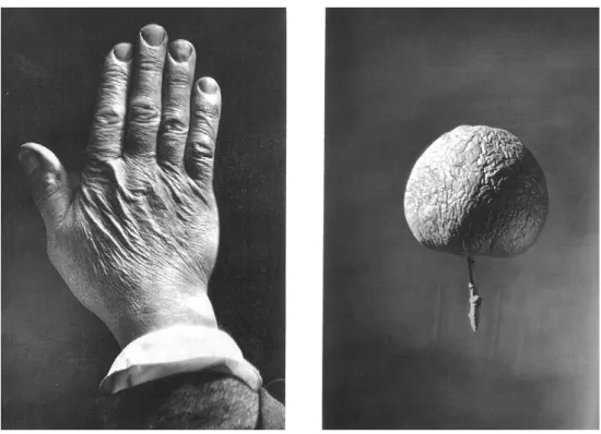
Fig. 1.In 1874, Alexander Nasmyth photographically illustrated the metaphor of a shrinking planet as a drying apple and an aged hand. From Nasmyth and Carpenter 1874.
The problem remained, though, that these systems were not only very large, but also remarkably complicated – and therefore did not reveal themselves easily. “The
Mountain systems are at the same time the most delicate and the most general traces
of the relief of the globe’s surface,” Beaumont wrote in 1852. At that point, he had already increased the number of his systems from initially four to more than twenty, but had to admit that “their number is yet undetermined” ( ´Elie de Beaumont 1852, 2, 3). But not only their number was undetermined, it was also still unclear what exactly had to be looked for. “What lines may eventually be found to prevail will. . . require much time and great patience to discover,” Henry de la Beche had already noted in 1835 with regard to ´Elie de Beaumont’s systems (cited in Greene 1982, 98). Twenty years later, this uncertainty still remained.
Aim´e Civiale’s Photo-Geological Project
Like Ritter, ´Elie de Beaumont seems to have been in need of new forms of visualization that could make those delicate traces evident. Maybe for this reason, he supported a
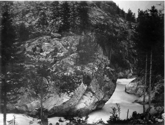
Fig. 2.La Fronti`ere Franc¸aise `a Barberine. From Aim´e Civiale’s album Le Mont Blanc et la Vall´ee de Chamounix, 1860/61, Biblioth`eque de l’Institut de France. In the album, containing 56
photographs in total, each print (about 27× 37 cm) occupies its own page.
photographic project that had begun in 1858 in the Pyrenees (see Thomas 1997, 88). Aim´e Civiale, polytechnicien and once officer in the engineer corps of the French army, came back from a trip to the Pyrenees with two photographic panoramas and several detail views that he believed “may be of interest to geology and geodesy” (Civiale 1859, 730). One year later, encouraged by ´Elie de Beaumont and the physicist Victor Regnault, who was also an amateur photographer (see Dahlberg 2005), Civiale photographed in the Bernese Oberland and brought back four panoramas. But this was just the starting point. Over the next decade, he took photographs of the Alps every summer, aiming for a complete “photographic reproduction of the Alps” (Civiale 1869, 985). Each spring he reported to the Acad´emie about his previous year’s journey, each time handing over an album containing his newest panoramas and detail photographs.
By 1868 he had traveled across almost the whole Alpine range. He had produced more than 40 large panoramas and more than 600 photographs of details (see figs. 2, 3, and 4). His last report to the Acad´emie des Sciences, in which he recapitulated his
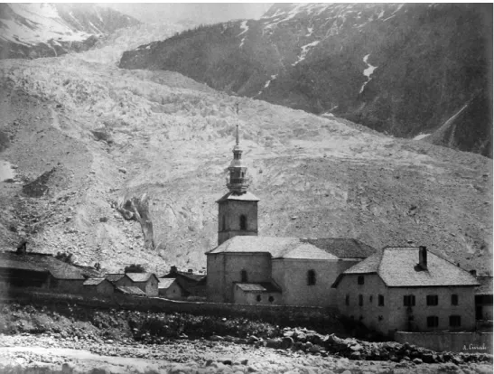
Fig. 3. Glacier et village d’Argenti`ere. From Aim´e Civiale’s album Le Mont Blanc et la Vall´ee de Chamounix, 1860/61, Biblioth`eque de l’Institut de France.
project, was published in the Comptes rendus of the session of 26 April 1869: “This work, commenced in 1859 and finished in 1868, lasted ten years without interruption. I aimed to provide, as much as I was able to, a complete idea of the great Alpine chains from the geographical and geological point of view. I ask the Acad´emie to accept my thanks for the benevolence and encouragement it offered to me during these ten years of work” (ibid., 989).
What Civiale meant by providing “a complete idea of the great Alpine chains” can perhaps be best appreciated by looking at a map that accompanied his final publication in 1882, Les Alpes au point de vue de la g´eographie physique et de la g´eologie (Civiale 1882) (see fig. 5). The map shows the horizon lines – the boundaries – of the panoramas using red, blue, and green lines. Together, these form a meandering belt that covers almost all the high Alps. Civiale had chosen to place his camera on the summits so that the horizon lines “form secants or at least tangents” of each other (ibid., 2). Looking at this map, one grasps how the virtually impossible “complete idea” of the Alps was to be realized: in Paris, perhaps in the library of the Acad´emie des Sciences, the different panoramas could be rolled out, looked at and compared synoptically. Taken together,
Fig. 4.Les Aiguilles Rouges. From Aim´e Civiale’s album Le Mont Blanc et la Vall´ee de Chamounix, 1860/61, Biblioth`eque de l’Institut de France.
all the panoramas would constitute one super-panorama that showed the Alps as no one had ever seen them before.1
Nobody had ever tried to photograph the Alps in such a systematic way. In its striving for completeness, it resembles the French Mission h´eliographique in 1851, which had aimed for a complete recording of the historic monuments in France (see Mondenard 2002). During its course, Civiale’s photo-geological project was well received by geologists and seems to have raised high expectations. Charles Saint-Claire Deville, geologist and disciple of ´Elie de Beaumont, commented on Civiale’s work extensively before the members of the Acad´emie in 1866. After having remarked upon
1The epistemological aspects of the panorama, which was used by earth scientists since the eighteenth century
and was a dominant representational form in the nineteenth century, cannot be represented in this article. There are many publications regarding this, see e.g. the recent ones: Bigg 2007; Crary 2002; Keller 2002; Speich 1999; and the already “classic” ones, Buddemeier 1970; Oettermann 1980; Sternberger 1955.
Fig. 5.Aim´e Civiale, Carte des Alpes pour servir aux voyages photographiques (detail), 1882.
geology’s “imperative need for precision,” he went on to say:
M. Civiale has understood that this gap can be filled in an irreproachable manner only by photography. Convinced that the geographer, the geologist, the meteorologist must find in this admirable discovery of our century a means above all controversy and independent of all preconceptions or all personal errors for recognizing the real form and relief of mountain massifs,. . . nothing has been neglected by him to arrive at results that are useful for geology. (Deville 1866, 874)
Much as Civiale’s project is praised here, it is nevertheless left unclear what the “results” of it were, and in which way exactly they were “useful.” The praise seems to aim more at general qualities of photography, as well as at the fact that Civiale had tried everything to arrive at useful results – but not so much at the result itself. If the project made a promise, it was a pretty open one – and one closely connected to the need for new images in the earth sciences.
It seems strange, though, that photography of all things would promise to bring about those much sought for new images. Wasn’t photography considered to be the superficial medium par excellence, reproducing all contingencies, but unable to reveal the deeper truth in nature? A “reproduction of a place, exact without doubt, but cold and mute,” as one of the early critics of photography had remarked (T ¨opffer 1980), the perfect example of a “weak image” in Ritter’s sense?
Obviously, photography’s status was not so unambiguous. There seems to have been something in the medium (or its usage) that legitimated high expectations and made Civiale’s project worthy of support – something that went beyond its “precision.” Somehow, it must have been thought that photography was able to deal with the threats of chance and contingency that so much haunted scientists like Ritter or ´Elie de Beaumont. It seems that the contingencies of geology and those of the medium itself were not identical – in fact, the latter may well have been thought to “tame” the former.2 As perhaps with all hopes, it is not so easy to extract them from the written documents of the time – instead, we need to take a closer look at Civiale’s practice of photography and at the images themselves.
3030 Meters above Sea Level
Long before dawn on the morning of 22 July 1866, a group of men and mules led by Aim´e Civiale departed from the little village of St. Luc in the Valais to ascend the summit of the Bella Tola. Their luggage consisted mainly of 250 kilograms of photographic equipment (see Deville 1866, 875; Stenger 1929–30, 194). Only four hours after departure and before seven o’clock in the morning, the party reached the summit. The camera was then positioned “3030 meters above sea level” (Civiale 1882, 256).
A week earlier, Civiale had reached Sierre, coming from Martigny through the Rhone Valley via the medieval town of Sion. Mules had been necessary to travel the last kilometers to St. Luc. The village was pitiful, Civiale later wrote, but there was a friendly guesthouse, the Hotel de la Bella Tola.3 He found the hotelier “of a rare disinterest” and added, somewhat enigmatically: “I met in this hotel two very amiable Englishmen; they were deaf and mute” (ibid., 255). The Bella Tola, the main attraction for the growing number of tourists coming to St. Luc, is a mountain of medium height and as such was ideal for Civiale’s project – high enough to offer a spectacular view but not so high as to dwarf the surrounding mountains and make them appear less impressive. In good conditions, more than 500 summits are visible from its summit.
2I take the notion that one kind of chance could “tame” another one from Hacking’s book about the emergence
of statistics: “Chance made the world seem less capricious: it was legitimated because it brought order out of chaos” (Hacking 1990, vii).
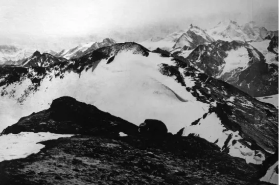
On that day, when Civiale and his companions reached the summit, the weather was perfect. The view was clear, and the Weisshorn, sixteen kilometers away, appeared in all its splendor. The photographic work immediately began, taking up the best part of the morning. For a complete 360◦panorama, Civiale needed fourteen successive, slightly overlapping photographs. The shooting required intense concentration and an elaborate procedure. Not only did the surrounding glaciers and snowfields reflect sunlight and threaten to overexpose the negatives, the changing position of the sun during the day, and with it the varying conditions of visibility, also had to be taken into consideration. Civiale began at seven o’clock with the first exposure facing north and worked his way around counter-clockwise (Deville 1866, 876). “To connect the prints it is indispensable,” Civiale explained, “to place the camera in a horizontal position; the instrument turns around its own axis in such a way that the first sheet covers the second by around one and a half centimetres, and so on for the following sheets” (Civiale 1860, 828). Due to the low sensitivity of the dry wax paper negatives, every exposure took between twelve and fifteen minutes.4 At noon Civiale took the last pictures facing east. At this point, the sun had changed position, and while nothing could be seen in the backlight of the morning, mountain chains and single ridges had now become visible (Civiale 1862, 602; Civiale 1866, 312; Deville 1866, 876).
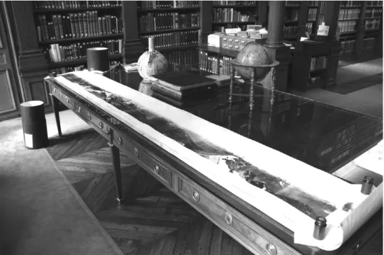
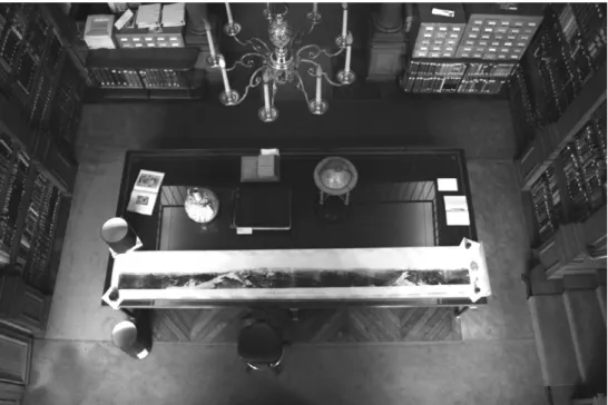
The outcome of Civiale’s efforts can still be viewed today in a number of Parisian libraries, for instance at the Biblioth`eque de l’Institut de France. The panorama is stored, together with twelve others, in a large cylindrical container. Unrolled, it measures over four meters in length and covers the huge table of the reading room (see figs. 6 and 7). Like all panoramas that are not arranged in a circle, but laid out flat, it is somewhat disorienting.
The two ends of the image do not quite meet, they do not seem to point in the same direction. The perceptible rupture in the circular image, however, is one of time rather than space, since between the two pictures at both extremities lay not twenty minutes (the approximate interval between successive photographs), but four or five hours (fig. 8).
The photograph of the southeast view gives a good impression of the mountain landscapes that Civiale may have been interested in (see fig. 9). A large ridge in the middle ground leads the eye into the depth of the image, where the summits vanish in the mist. “To provide physical geography and geology with the indications they await,” Civiale wrote, “the photographs have to be oriented such as to reproduce in the best possible way the structure of the rocks, the disposition of the layers of the terrain, the forms and inclination of the glaciers” (Civiale 1863, 523). In the foreground, the little plateau of the Bella Tola – where Civiale was standing – takes up a lot of space. A closer
4Compared to the already commonly used glass negatives (wet collodion process), the wax paper negatives were
less precise, but had according to Civiale the advantage of being more robust and easier to process (see Davanne 1880, 209). For exposure times of the wax paper negatives, see Chevalier 1867. For the calotype process in general, see Jammes and Janis 1983 and Taylor and Schaaf 2007.
Fig. 6. View of Aim´e Civiale’s Panorama circulaire pris de la Bella Tola lying on a table at the library of the Institut de France. Photo by the author.
examination of the panorama shows that, despite the full circle panoramic view, neither the photographer nor his crew are anywhere to be seen. One imagines how the whole crew, including luggage and equipment, moved around the camera on its tripod, to stay out of the field of view. This odd absence perhaps best captures the particular time structure of the photographic panorama. While giving the impression of simultaneity – as if one were standing on the summit of the Bella Tola, looking around ad libitum – it really consists of many disparate points in time: fourteen moments, each a quarter of an hour long, a long glance over a whole morning in the year 1866.
As we have seen, the panorama from the Bella Tola is only a small fragment of Civiale’s photographic project. Since 1859, he had traveled every summer through the Alps and made photographs of rocks, valleys, glaciers, and mountain chains. In his first note concerning his Alpine photographs, read to the members of the Acad´emie des Sciences by ´Elie de Beaumont, he reflected on the difference between former uses of photography and his approach:
The mountain countries have provided photographers with a great number of landscapes that are of interest under picturesque and artistic aspects; but so far, one has been but little occupied with the advantages that geology and the physics of the globe may draw from photographs taken under neatly defined conditions. (Civiale 1860, 827)
Fig. 7.Aim´e Civiale’s Panorama circulaire pris de la Bella Tola seen from the gallery of the reading room of the Institut de France. Photo by the author.
But the division line between picturesque and scientific usages of mountain photography had never been as clearly marked as Civiale suggested. Since the 1840s, only a few years after Daguerre and Talbot had presented their respective processes, mountains had been the subject of photographic interest. Some of the early daguerreotypes of Joseph Philibert Girault de Prangey, for example, taken between 1846 and 1850, can hardly be accounted for by solely picturesque appeal. The pictures give evidence of a scientific interest in the limestone structures of the Jura (see figs. 10 and 11) or in glaciers like the Mer de Glace5near Chamonix (see Barger and White 1991, 74; Mauron 2008).
Also in the 1840s, an eminent figure like John Ruskin made a series of daguerreotypes in the Alps. He claimed to have made the first photograph of the Matterhorn (Ruskin 1879, 4); other pictures show the aiguilles around Chamonix or, again, the Mer de Glace. Ruskin, although known today mainly as an art critic and theoretician, was much concerned with geological questions and even published some scientific papers, e.g. in the Geological Magazine (Ruskin 1865). His case strikingly
5The Mer de Glace had been one of the favorite image subjects from the eighteenth century on (see Wagner
Fig. 8.Aim´e Civiale, Panorama circulaire pris de la Bella Tola, photograph/photogravure, 1866–1882. From Thomas 1997, pp. 86–87.
.
https://doi.org/10.1017/S026988970999007X
https:/www.cambridge.org/core
. University of Basel Library
, on
11 Jul 2017 at 11:41:33
Fig. 9.Aim´e Civiale, Panorama circulaire pris de la Bella Tola, 1866 (detail of figure 6).
Figs. 10 and 11.Joseph Philibert Girault de Prangey, Limestone rocks in the Jura. Daguerreotypes, 1846–50. From Mauron 2008, pp. 165 and 160.
shows how close scientific and aesthetic interests in photography could be intertwined by the mid-century (see e.g. Gully 1993; Harvey 1984; Haslam 2005; Wildman 2006). Around 1850, photographic inquiries in the mountain regions became more numerous; they can be mentioned here only partly. One example is the Comte Joseph Vigiers, who made a photographic excursion to the Pyrenees in 1853. Twenty of his salt-paper prints are stored today in the Mus´ee d’Orsay in Paris (Heilbrun 2003).
Another example is Paris-based Friedrich Martens, who, after having experimented with panoramatic daguerreotypes in the 1840s, sent a photographic panorama of the Swiss Alps to the Acad´emie des Sciences in 1854. La Lumi`ere reported proudly that
´
Elie de Beaumont himself had presented it and had remarked that “it renders with the wonderful exactitude of photography the geological aspect of those icy regions” (Anonymous 1854; about Martens, see e.g. Breguet 1981, 13–15).
As early as 1849, the Mulhouse-based manufacturer and glaciologist Daniel Dollfus-Ausset assigned the photographers Jean-Gustave Dardel and Camille Bernab´e to take photos of Alpine glaciers;6in 1855, he took a share in the newly found photographic enterprise of the Bisson brothers and commissioned them to make pictures in the Bernese Alps (Lagoltiere 1986; Morand and Kempf 1989, 107–112; Steiner, Zumb ¨uhl and Bauder 2007, 88). Louis-Auguste and Auguste-Rosalie Bisson were among the most famous photographers of their time, and their Alpine subjects aroused broad public interest. In 1860, they accompanied Napol´eon III and his wife on a voyage to the province of Savoy, which had become part of France just a year earlier. This resulted in an album called Souvenir de la Haute-Savoie, Le Montblanc et ses Glaciers, par
MM. Bisson fr`eres, Photographes de l’Empereur. Between 1859 and 1861, the Bissons also
tried to climb Mont Blanc and make the first images from the summit (Chlumsky, Eskildsen, and Marbot 1999; Decker Heftler and Spies 2003).
The spectacular images of the Bissons inspired many others to photograph the Alps, among them the Austrian Gustav J¨agermayer, who in 1863 made a sumptuous photo-graphic expedition in the Austrian Alps. In choosing the right viewpoints for his large wet collodion plates, J¨agermayer was supported by a landscape painter (Gr ¨oning 2008). It becomes obvious, by these few examples, that mountains – and especially the Alps – were by no means unknown photographic territory when Civiale started his campaign in 1859 (see also Baier 1965, 444–449; Faber 2008; Guichon 1984; Holzer 2006; Stenger 1929–30). Many photographers, among them the Bissons, had also already underlined the scientific value of their images (see the entry Geology in Hannavy 2008). None of them, however, had made a clear distinction between artistic, touristic, or scientific usages of photography. It seems that before 1860, it was widely accepted that aesthetic and epistemic qualities of images did not interfere. Now, it suddenly seemed necessary to draw a strict line between the two. “The picturesque side is here only of secondary importance,” Civiale wrote (Civiale 1862, 602). Charles Saint-Claire Deville, geologist and member of the Acad´emie des Sciences, was more resolute when praising Civiale’s photographs in 1866:
If the question is to reproduce by imitation a natural scene or object, one can adopt two, if not opposed, then at least completely different perspectives: that of art or that of science.. . . The absolutely exact or photographic reproduction of a large territory
6A reproduction of a daguerreotype of the Bernese Alps by Dardel (dated 1849) can be found in Morand and
becomes as rarely what we call a landscape as the textual reproduction of a scene of ordinary life or of an historical episode can become without alteration a theatre play or a poem. (Deville 1866, 873)
Deville used the notion that photography was unable to produce landscapes to underline his argument that it was especially fit for the exact sciences of geology and geodesy. He compared Civiales’ photos with the artistic movement called “realism” – a notion he found “deplorable” in art, but of eminent use for scientific purposes.7
Interesting enough, many of Civiales photographs do not seem to differ much aesthetically from contemporary productions by “landscape” photographers such as Adolphe Braun or William England – with the one major distinction that Civiale never used human figures as scale unit or repoussoir (see figs. 2, 3 and 4). Many of the subjects are similar, though, and besides glaciers and mountains also include houses, villages, or valleys. The difference lies not so much in the purely visual, but in the way these images were made: “photographs taken under neatly defined conditions,” as Civiale himself had put it. This meant controlling and recording the circumstances of the photographic process as completely as possible, so that everything would be as reproducible as possible; for that end, Civiale not only chose summits of comparable height, kept the camera rigorously horizontal, and tried to take photos under the same atmospheric conditions; he also collected numerous mineralogical samples,8measured angles, took barometrical readings, made drawings, and wrote diary entries (Tissier and Staszak 2006, 160). Unfortunately, those do not seem to have survived.
The Unexpected
When taking a closer look at Civiale’s photographic panorama from the Bella Tola, a few details come to our attention that might have remained unnoticed at first sight. To the North, a signal prominently marks the highest point of the summit, making it clear that the Bella Tola had already been topographically surveyed (see fig. 12). A little closer to the camera lens, a wooden bench can be seen. A piece of Alpinist infrastructure, it points to the fact that this is a comparatively accessible peak, and a good spot for those seeking an impressive view of the Valais Alps. Years before Civiale had taken his photographs, travelers had sat here and enjoyed the panorama. In figure 9, another small object can be seen. In the foreground, a forgotten bucket leans on a rock,
7In 1855, Gustave Courbet had held his Pavillion de R´ealisme in Paris, opposite the official exhibition of the
World Fair. This started fierce debates about artistic values (see e.g. Fried 1990; Herding 1978). Deville may have followed an argument Charles Baudelaire had used in his Salon de 1859, namely, as Bernd Stiegler has pointed out, that photography was a “radicalization of the modes of representation that also marked realistic literature and painting” (Stiegler 2006, 51), and was therefore not worthy of being called art (see Baudelaire 2006).
Fig. 12.Aim´e Civiale, Panorama circulaire pris de la Bella Tola, 1866 (detail of figure 6). reminding us of the photographic labor that had to be done on the spot, and of the participants involved.9
Neither the signal, nor the bench, nor the bucket seem to be really part of what Civiale’s panorama is about. They just happened to be there, more or less by accident. In the case of the signal, Civiale even reports that he tried to bring down the flag, but didn’t succeed (Civiale 1882, 256). Obviously, he wanted to control what was in the photographs as much as possible, or at least avoid anything that could distract from the mountain view. On the bench and the bucket, Civiale doesn’t comment, and at least for the bucket, it is probable that he just overlooked it when exposing the image.
So why then bother with these small and obviously not very important details? Admittedly, none of them gave any of the geological or geographical information that earth scientists were hoping for. The challenge in approaching Civiale’s images today is that there seems to be a gap between what those images seemingly promised, and what they could in fact deliver. Nowhere is it stated that those images were actually used
9It is unclear, though, how much of the actual photographic labor had to be done on the spot. The dry
wax-paper process would theoretically have enabled preparing the negatives on the eve of each excursion, and developing them after the return; on the other hand, contemporary sources state that Civiale had to carry his whole equipment of 250 kg to the summits (see Deville 1866), which would speak for more elaborate procedures on the spot.
by earth scientists, that they produced new insights, or that they helped in formulating new theories – they probably didn’t. Only this is something Civiale couldn’t have known when conducting his project. Rather, he and his supporters at the Acad´emie des Sciences must have had good reasons to hope for impressive results. As I said before, it is not so easy to localize those hopes. Photography promised something, but it might not even have been clear to the contemporaries what this “something” was exactly. When writing about hopes, we therefore have to allow for a certain amount of historical speculation.
This is where the signal, the bench, and the bucket come in. Even if at a first glance the mountains on Civiale’s images didn’t reveal anything spectacular, those small details could have made manifest photography’s potential. They spoke not only of the surveying of the Alps, of touristic activities, or of the labor that mountain photography required; they also alluded to a quality of photography that may have been one of the main reasons that it was so attractive to earth scientists in need of new visualizations. It was unpredictable what all would be visible on a photo, what later viewers would discover. This represented a certain threat on the one hand, and one can see in Civiale’s case how much he tried to control the photographic conditions to minimize those contingencies.
But on the other hand, the appeal of photography was largely due to exactly this capability: to bring things to the attention of the viewer that the operator of the camera could have overlooked. “It is most remarkable that often things are found in photographs that cannot be noticed on the natural objects themselves,” a visitor at the first international photographic exhibition in Berlin in 1865 remarked (Landois 1865, 452). From the very beginning, photography was known for recording such little unnoticed details. It seems that all the exactness, precision, and truth of the photographic image that everybody talked about so much was based on this ability to show what nobody had expected or even hoped for, but what had been there all the same. These small elements of chance were what arrested the attention of so many observers in the early decades of photography. “In a picture you can find nothing the artist has not seen before you; but in a perfect photograph there will be as many beauties lurking, unobserved, as there are flowers that blush unseen in forests and meadows,” the American physician and essayist Oliver Wendell Holmes wrote in 1859, also contrasting artistic image production against the “mechanical” photography. He added: “This distinctness of the lesser details of a building or a landscape often gives us incidental truths which interest us more than the central object of the picture.. . . The more evidently accidental their introduction, the more trivial they are in themselves, the more they take hold of the imagination.” As so many others, Holmes saw a photograph as something that could be fully appreciated only retrospectively, and that had to be looked at over and over again (Holmes 1859). A similar argument was brought forward in 1864 by the French astronomer Herv´e-Auguste Faye, who was surprised to find that certain “defects” he saw on photographs of a solar eclipse were in fact not defects, but sunspots. “As a general thesis,” Faye noted, “one sees only the things
Fig. 13.Henry Fox Talbot, Boulevard des Capucines, calotype print, ca. 1843. From Amelunxen 1988.
that are of interest at the moment of observation; the rest almost always escapes one’s attention. Automatic observation, on the contrary, registers everything: that which one is looking for at the moment and that which one will be looking for later” (Faye 1989, 452).
One of the most pertinent examples of what could be called the “subsequentiality” of photography (for want of a better translation of the German Nachtr¨aglichkeit) is perhaps Henry Fox Talbot’s description of the photo Boulevard des Capucines, the second plate in his “Pencil of Nature” (fig. 13):
This view was taken from one of the upper windows of the Hotel de Douvres, situated at the corner of the Rue de la Paix. The spectator is looking to the Northeast. The time is the afternoon. The sun is just quitting the range of buildings adorned with columns: its fac¸ade is already in the shade, but a single shutter standing open projects far enough forward to catch a gleam of sunshine. The weather is hot and dusty, and they have just
been watering the road, which has produced two broad bands of shade upon it, which unite in the foreground because, the road being partially under repair (as is seen from the two wheelbarrows, &c. &c.), the watering machines have been compelled to cross to the other side.
By the roadside a row of cittadines and cabriolets are waiting, and a single carriage stands at a distance a long way to the right. A whole forest of chimneys borders the horizon: for, the instrument chronicles whatever it sees, and certainly would delineate a chimney-pot or a chimney sweeper with the same impartiality as it would the Apollo of Belvedere. (Talbot 1844–46)
It is remarkable what happens to all those accidental details in the course of Talbot’s description: they not only become much more important than they probably would have been if somebody had looked out of the same window of the Hotel de Douvres at the same time, they are also supplied with reasons for their being there. One could say that everything that Talbot describes was completely contingent: the shutter could have been closed, the road already repaired, the watering machines come ten minutes later. It was really a product of chance that all those incidents that happened, happened (as it is, in a way, always), they were as meaningless or meaningful as anything else, and nobody would have had a reason to notice them anyway. But the fact that Talbot stood in the window with his camera, and later looked at the result, did something to those contingencies. Being on the image and being looked at, every detail became potentially meaningful. Every detail was able to tell a story about the reasons for its being there, or became a trace of something else – like the “broad bands of shade” that point to the watering machines, but also tell us about the weather on that particular day (“hot and dusty”), or the efforts of the municipality in mid-nineteenth-century Paris to make city life in the summer more endurable. One of the most interesting examinations of this often-cited passage comes from the historian of photography Timm Starl. He remarks that in his text, Talbot distinguished between the production and reception of the image. Starl writes:
But every now and then, there is that lightning flash of chance which the photographer does not notice and the viewer often cannot recognize. Talbot touched upon this aspect when referring to the passing of the water sprinkler trucks and the traces left by them – a dominant configuration in the photograph. Thus he added to the picture his emphasis of the element of chance, as though wanting to make sure that the audience did not overlook this capacity, exclusive to photography among the media, of recording such an essential constitutive element of any experience of reality.
However, Starl is not only interested in photography’s capability to record contingent elements, he also analyzes the change those elements undergo when being captured. According to him, even though still accidental when they happen during the exposure, they change their status in the image: “Making chance visible cancels out its unique
quality, which is lost between the creation of the image and the recognition of the result” (Starl 1987, 82–83; see also Starl 1992).
Strangely enough, something seems to happen to those details between the exposure and the examination of the image: they somehow lose some of their contingency. “A mirror with memory” Holmes had called the daguerreotype (Holmes 1859). However, this memory was certainly not only an accessory, but changed the status of the “mirror” completely. The “subsequentiality” of photography – the fact that, in contrast to traditional forms of scientific representation, its epistemic value was not so much based on the act of its making but more on the later perception of the image10 – made all the elements in an image potentially readable. Photography’s promise to bring out the unexpected included both: to make things visible that nobody would have thought of, and to give meaning to details that nobody had deemed important. Seemingly, contingency in the world and contingency in the photographic image were two different things. Objects or events entered the photographic image unexpectedly and by chance, but on their way lost some of their contingency.
Explorative Photography
When thinking about the question of what made photography so attractive for earth scientists in the mid-nineteenth century, and especially for the representation of mountains, I believe we have to consider photography’s promise to bring out the unexpected at least as much as photography’s “exactness” or “objectivity” (see Daston and Galison 2007). We might even have to regard those classic qualities of photography as a by-product of the unexpected – meaning that its capability to bring out unexpected details was the proof for its precision, and the fundament of the possibility to even notice this precision. So when Charles Saint-Claire Deville talked about geology’s “imperative need for precision,” adding that this need could only be satisfied by photography (Deville 1866, 874), there might be already an understanding of “precision” at work that is at the core photographic.
For scientific mountain photography around 1860, and especially in Civiale’s case, we have to take into account that the promise of the unexpected must have been particularly attractive. As we have seen, earth sciences were in need of new representations that would make it possible to identify patterns in the arrangement of mountain chains (see also Thomas 1997). But there was neither a commonly accepted orogenic theory that only had to be proved by those new images, nor was it clear what could count as a relevant pattern. A successful new medium needed to give answers
10For scientific drawings, for example, it was often stated that the knowledge about an object was closely linked
to the process of drawing it. Drawing was sometimes considered to be a “training of the eye” which photography could not provide for (see e.g. Schickore 2002).
to questions that hadn’t even been posed yet. Photography gave hope of doing so: “The true means to answer the questions I am asking here, and moreover those that the future is still retaining, is photography,” the astronomer Faye stated in 1862 (Faye 1862, 547). What held for observations of the sun seems to have applied to the study of mountains as well. If photography was considered a medium that might replace the usual “weak images,” it might have been precisely because it promised to produce results that were unforeseeable.
In a recent article, Peter Geimer examined “the unforeseeable” in photography. To localize the point where the intentions of the photographer and the momentum of reality touch, he uses the term “incident” (Vorfall, Ereignis) – something that happens to the image, and that the photographer can only partly control. This, however, is not a defect, but basic to many scientific applications of photography. “Visualizations in the sciences would be a redundant affair if scientists could exactly anticipate the resulting images of their apparatuses at any one time,” Geimer remarks (Geimer 2007).
Beginning with Ian Hacking (Hacking 1983), historians and sociologists of science have pointed out that experiments are not simply testing theories, but are generative for them (e.g. Heidelberger 1998; Pickering 1992; Rheinberger 2001). For his study on electrodynamics around 1820, Friedrich Steinle has coined the term “explorative experiments.” Steinle focuses on periods of “epistemic uncertainty,” when concepts and theories have become unreliable. “To test a hypothesis or expectation, there has to be a reliable language, in which it can be formulated and that allows to ask the experimental question, to design and to evaluate the experiment. When an abstract concept is missing or shaken in its reliability, the experimental labour will have a different character” (Steinle 2005, 20).
Around 1850, orogenic theory in Europe was in such a state of uncertainty (see e.g. Greene 1982, 93–121). And even though Civiale’s project is hardly an experiment in the narrow sense, it shows elements of an “explorative” approach. With allusion to Steinle, one could call it “explorative photography.”11
What is won when we use this label “explorative photography” to describe Civiale’s work? First of all, it helps us to understand why photography was so attractive at a time when its usages were anything but well-defined. More importantly, though, it makes clear that what Civiale did was by no means the odd enterprise of an eccentric outsider, but good scientific practice. What may have seemed an unprofessional fumbling, a being-in-the-dark, turns out to be a valid approach. Photographing the mountains and hoping that something useful will appear can, under certain conditions, be as justified as trying to find something specific or to prove a hypothesis by photographic means.
What distinguishes Civiale from a scientist or an experimenter, though, is that he himself had no ambition to evaluate his images. He obviously understood himself as a supplier of images, not as a theoretician; their utilization he left to others. This was, as we have seen, one of the basic characteristics of photography: it separated the process of image-making from that of perception. It seemed to make no difference who made the photo (and this notion underlay many of the arguments during the nineteenth century concerning whether photography or drawing were more suitable for scientific purposes); it was important that it could be potentially used afterwards. The forgotten bucket or the wooden bench were certainly not the kind of unexpected that anybody was hoping for. What they were speaking of, however, was photography’s potential to record things nobody had thought about, and to make contingent appearances seem less contingent. What was possible for a bucket, could have been also possible for traces hinting at mountain systems.
Conclusion
In 1882, more than fourteen years after his last journey, Civiale published his only book
Les Alpes au point de vue de la g´eographie physique et de la g´eologie. Voyages photographiques dans le Dauphin´e, la Savoie, le Nord de l’Italie, la Suisse et le Tyrol. Featuring expensive
heliogravure reproductions of some of Civiale’s photos and two separate maps, it was about three to four times as expensive as comparable books.12 Reactions to it varied. While one reviewer found that the illustrations left “nothing to be desired” and that it was “indeed difficult to imagine any delineations of the earth’s surface more suitable for purposes of instruction, so far as the Alpine phenomena are concerned” (Rye 1882), another critic was less enthusiastic: “This is a very exasperating book for the reviewer.” Not only did he remark on its unclear genre – between guidebook, traveler’s diary, and topographical handbook – but he failed to identify the exact purpose or object of Civiale’s work, just that it was vaguely connected to geological research. The main problem to this reviewer was that Civiale had included only fourteen reproductions, none of them a complete panorama, so that the book remained “a fragment without the photographs which ought to illustrate it.” To make things worse, according to the critic, the photographs varied in quality: “that of the ‘Mont Blanc from the Buet,’ which occupies the post of honour as the frontispiece, singularly fails to represent a most impressive scene; and ‘the Weisshorn from the Bella Tola,’ is simply a disastrous failure” (Anonymous 1884).
As much as Civiale’s photos had been praised during their making, and as many hopes as had been connected with them, in the end it seemed that they could not keep their promise. As remarked before, they obviously were not used for geological
research. ´Elie de Beaumont died in 1874, and his r´eseau pentagonal “perished as soon as he and Saint-Claire Deville were no longer around to hammer it into the heads of French geologists and mining engineers” (Greene 1982, 193). Civiale’s book really is a document of helplessness, and the long time span between the end of Civiale’s campaign in 1869 and the book’s appearance is telling: Civiale obviously was unsure what to do with his photos. Initially, he had not intended to do anything with them other than hand them over to scientists. But as it became more and more evident that no one would really use this treasure, he must have thought it best to at least publish his material.
From a later point of view, Civiale’s contribution can be located in the upcoming field of photogrammetry. Since the late 1850s, mostly military engineers had thought about applying photography in geodesy and cartography. This happened independently in France, Austria, Italy, and Germany (see e.g. Laussedat 1859; Porro 1863; Tschudi and Gerwig 1873). But only from the 1880s on, was the procedure advanced enough to be professionally employed. From then on, photogrammetry became one of the most successful and widespread fields of application for photography (Meydenbauer 1912; Ollivier 1929; Weiss 1913; see also Atkinson 1995; Ponstingl 2001; Ponstingl 2002).
Aim´e Laussedat, who was sometimes called the “father of photogrammetry” (Eder 1932, 557), stated in 1901 that Civiale had “ploughed a first and deep furrow in the field of photogeology” (Laussedat 1901, 20). And indeed it seems that projects such as Civiale’s were necessary to fathom the possibilities of the new medium, and to inspire potential applications. That mountain photography was able to lead to new and unexpected fields of usage was demonstrated when Albrecht Meydenbauer visited the photographic exhibition in Berlin in May 1865. Meydenbauer, a German construction engineer, had been experimenting with the photographic measurement of buildings for several years. Looking at the exhibits, something suddenly came to his mind. “Among the pictures of this exhibition,” Meydenbauer writes, “were two very beautiful Alpine landscapes, and by chance the author caught sight of an immense mountain with inaccessible peaks and snowfields on two different, adjacent photographs. Only by this sight did it become clear to the author in a single moment – in a flash – that photogrammetry could be used for the survey of any given object” (Meydenbauer 1867, 9). The application of photogrammetry for land surveying purposes was, according to the legend, unexpectedly born. Sad enough, it is not recorded which images Meydenbauer had seen – it could well have been Civiale’s.13
13The exhibition catalogue (Jacobsen, Melcher, and Vogel 1865) lists four images by Civiale, among them a
panorama of the Bernina Chain. The images had been exhibited in Vienna one year earlier (see Gr¨oning 2003, 89). Other photographers who contributed Alpine images to the Berlin exhibition included Gustav J¨agermayer, Adolphe Braun, and Auguste Rosalie Bisson (see also Anonymous 1865). I thank Evke Rulffes for looking at the exhibition catalogue for me in Berlin.
Acknowledgments
I would like to thank all the participants of the workshop “The Laboratory of Nature” for the stimulating discussions. I am especially grateful to Alexandre M´etraux and the editors of this issue for the many useful hints regarding my article.
References
Amelunxen, Hubertus von. 1988. Die aufgehobene Zeit. Die Erfindung der Photographie durch William Henry Fox Talbot. Berlin: Nishen.
Anonymous. 1854. “Portraits st´er´eoscopiques de M. Cludet; Vues de Suisse de M. Martens.” La Lumi`ere 4: n. p.
Anonymous. 1865. “Die internationale photographische Ausstellung in Berlin.” Photographisches Archiv 6:280–282; 305–308.
Anonymous. 1884. “Reviews and Notices.” Alpine Journal 11:52–53.
Arago, Franc¸ois. 1839. “Le daguerr´eotype.” Comptes rendus des s´eances de l’Acad´emie des Sciences 9:250– 267.
Atkinson, K. B. 1995. “Deville and Photographic Surveying.” Photogrammetric Record 86:189–195. Baier, Wolfgang. 1965. Quellendarstellungen zur Geschichte der Fotografie. Leipzig: Fotokinoverlag. Barger, M. Susan and William B. White. 1991. The Daguerreotype: Nineteenth-century Technology and Modern
Science. Washington: Smithsonian Institution Press.
Baudelaire, Charles. 2006. Salon de 1859: texte de la Revue franc¸aise. Paris: Honor´e Champion.
Bigg, Charlotte. 2007. “The Panorama, or La Nature A Coup d’Œil.” In Observing Nature – Representing Experience. The Osmotic Dynamics of Romanticism 1800–1850, edited by Erna Fiorentini, 73–95. Berlin: Reimer.
Breguet, Elizabeth. 1981. 100 ans de photographie chez les Vaudois 1839–1939. Lausanne: Payot.
Buddemeier, Heinz. 1970. Panorama, Diorama, Photographie. Entstehung und Wirkung neuer Medien im 19. Jahrhundert. Munich: Fink.
Chevalier, Arthur. 1867. L’ ´Etudiant Photographe. Trait´e pratique de photographie `a l’usage des amateurs. Avec les proc´ed´es de MM. A. Civiale, E. Bacot, A. Cuvelier, L. Robert. Paris: Eug`ene Lacroix.
Chlumsky, Milan, Ute Eskildsen, and Bernard Marbot. 1999. Die Br¨uder Bisson. Aufstieg und Fall eines Fotografenunternehmens im 19. Jahrhundert. Amsterdam: Verlag der Kunst.
Civiale, Aim´e. 1859. “Photographie: Note accompagnant la pr´esentation de diverses ´epreuves obtenues par M. Civiale fils.” Comptes rendus des s´eances de l’Acad´emie des Sciences 48:730–731.
Civiale, Aim´e. 1860. “Note sur l’application de la photographie `a la g´eographie physique et `a la g´eologie.” Comptes rendus des s´eances de l’Acad´emie des Sciences 50:827–829.
Civiale, Aim´e. 1862. “Note `a l’Acad´emie.” Comptes rendus des s´eances de l’Acad´emie des Sciences 54:601–603. Civiale, Aim´e. 1863. “L’Oberland du Valais et le mont Rose.” Comptes rendus des s´eances de l’Acad´emie des
Sciences 56:523–525.
Civiale, Aim´e. 1866. “Communication `a la Soci´et´e.” Bulletin de la Soci´et´e franc¸aise de photographie 311– 313.
Civiale, Aim´e. 1869. “Note sur l’application de la photographie `a la g´eographie physique et `a la g´eologie. Les Alpes de la Savoie et du Dauphin´e.” Comptes rendus des s´eances de l’Acad´emie des Sciences 68:985– 989.
Civiale, Aim´e. 1882. Les Alpes au point de vue de la g´eographie physique et de la g´eologie. Voyages photographiques dans le Dauphin´e, la Savoie, le Nord de l’Italie, la Suisse et le Tyrol. Paris: Rothschild.
Crary, Jonathan. 2002. “G´ericault, the Panorama, and Sites of Reality in the Early Nineteenth Century.” Grey Room 9:5–25.
Dahlberg, Laurie. 2005. Victor Regnault and the Advance of Photography: The Art of Avoiding Errors. Princeton: Princeton University Press.
Daston, Lorraine and Peter Galison. 2007. Objectivity. New York: Zone Books.
Daubr´ee, Auguste. 1897. “Biographie de ´Elie de Beaumont.” In Livre du Centenaire, 1794–1894, edited by ´Ecole polytechnique. Paris: Gauthier Villars.
Davanne, Alphonse. 1880. “Pr´esentation de la Carte des Alpes offerte par M. Civiale.” Bulletin de la Soci´et´e franc¸aise de photographie 208–211.
Decker, Heftler, Sylviane de and Werner Spies. 2003. Montblanc. Die Eroberung durch die Fotografie. Die Sammlung Sophie und J´erˆome Seydoux. Cologne: DuMont.
Deville, Charles Saint-Claire. 1866. “Rapport relatif `a des ´etudes photographique sur les Alpes, fait au point de vue de l’orographie et de la g´eographie physique par M. Aim´e Civiale.” Comptes rendus des s´eances de l’Acad´emie des Sciences 62:873–881.
Eder, Josef Maria. 1932. Geschichte der Photographie. Halle: Knapp. ´
Elie de Beaumont, L´eonce. 1829–30. Recherches sur quelques-unes des re´volutions de la surface du globe, etc. (M´emoire lu par extrait `a l’Acad´emie des Sciences, le 22 Juin, 1829). Paris.
´
Elie de Beaumont, L´eonce. 1852. Notice sur les syst`emes des montagnes. Paris: P. Bertrand.
Faber, Monika, ed. 2008. Die Weite des Eises, Arktis und Alpen 1860 bis heute (Ausstellungskatalog. Albertina Wien). Ostfildern: Hatje Cantz.
Faye, Herv´e-Auguste. 1862. “Rapport sur les dessins astronomiques et les ´epreuves photographiques de M. Warren de la Rue.” Comptes rendus des s´eances de l’Acad´emie des Sciences 54:545–549.
Faye, Herv´e-Auguste. 1989. “Sur l’emploi de la photographie dans les observations astronomiques (1864).” In La Photographie en France, edited by Andr´e Rouill´e, 451–453. Paris: Macula.
Fl ¨uckiger-Seiler, Roland. 1999. “Vom Basislager f ¨ur Erstbesteigungen zum Aussichtshotel im Gebirge. Walliser Hotelbauten auf 1500 bis 2500 Meter ¨uber Meer.” Kunst + Architektur in der Schweiz 50:13–24.
Francke, A. 1883. “Die alpine Literatur des Jahres 1882.” Jahrbuch des Schweizer Alpenclub 18:479–502. Fried, Michael. 1990. Courbet’s Realism. Chicago: University of Chicago Press.
Geimer, Peter. 2007. “Das Unvorhersehbare.” In Bilderfragen. Die Bildwissenschaften im Aufbruch, edited by Hans Belting, 101–118. Paderborn: Fink.
Greene, Mott T. 1982. Geology in the Nineteenth Century: Changing Views of a Changing World. Ithaca: Cornell University Press.
Groh, Dieter and Ruth Groh. 1991. “Von den schrecklichen zu den erhabenen Bergen. Zur Entstehung ¨asthetischer Naturerfahrung.” In Weltbild und Naturaneignung. Zur Kulturgeschichte der Natur, edited by Dieter and Ruth Groh, 92–149. Frankfurt am Main: Suhrkamp.
Gr ¨oning, Maren. 2003. “Die erste Fotoausstellung im deutschsprachigen Raum 1864.” In Das Auge und der Apparat. Eine Geschichte der Fotografie aus den Sammlungen der Albertina (Ausstellungskatalog. Wien 2003), edited by Monika Faber, 80–109. Paris: Seuil.
Gr ¨oning, Maren. 2008. “Gustav J¨agermayers ‘ ¨Osterreichische Alpen’.” In Die Weite des Eises, Arktis und Alpen 1860 bis heute (Ausstellungskaalog Albertina Wien), edited by Monika Faber, 24–33. Ostfildern: Hatje Cantz.
Guichon, Franc¸oise, ed. 1984. Montagne. Photographies de 1845 `a 1914. Paris: Deno¨el.
Gully, Anthony Lacy. 1993. “Sermons in Stone: Ruskin and Geology.” In John Ruskin and the Victorian Eye, edited by Susan Casteras, 158–183. New York: Harry N. Abrams/Phoenix Art Museum. Hacking, Ian. 1983. Representing and Intervening: Introductory Topics in the Philosophy of Natural Science.
Cambridge: Cambridge University Press.
Hacking, Ian. 1990. The Taming of Chance. Cambridge: Cambridge University Press.
Hannavy, John, ed. 2008. Encyclopedia of Nineteenth-Century Photography. New York/London: Routledge. Harvey, Michael. 1984. “Ruskin and Photography.” Oxford Art Journal 7:25–33.
Haslam, Ray. 2005. “Ruskin, Drawing and the Argument of the Lens.” Ruskin Review and Bulletin 2:17–24.
Heidelberger, Michael. 1998. “Die Erweiterung der Wirklichkeit im Experiment.” In Experimental Essays – Versuche zum Experiment, edited by Michael Heidelberger and Friedrich Steinle, 71–92. Baden-Baden: Nomos Verlagsgesellschaft.
Heilbrun, Franc¸oise. 2003. “Les Vues des Pyr´en´ees prises en 1853 par le Comte Joseph Vigier, d´epos´ees par la Fondation Dosne-Thiers au Mus´ee d’Orsay, en 1983.” In ´Eclats d’histoire. Les collections photographiques de l’Institut de France, 1839–1918, edited by Anne Cartier-Bresson, Laurence Desroy-Hamouda, and Catherine Dalarun-Mitrovitsa, 234–235. Arles: Actes Sud.
Herding, Klaus. 1978. Realismus als Widerspruch. Die Wirklichkeit in Courbets Malerei. Frankfurt am Main: Suhrkamp.
Holmes, Oliver Wendell. 1859. “The stereoscope and the stereograph.” Atlantic Monthly 3:738– 748.
Holzer, Anton. 2006. “Hinauf! Fotografie im Hochgebirge (1849–1914).” Berge im Kasten. Fotografie aus der Sammlung des Deutschen Alpenvereins, 1870–1914, 14–31. Munich: Deutscher Alpenverein. Jacobsen, Melcher and Vogel. 1865. “Catalog der internationalen photographischen Ausstellung zu Berlin
veranstaltet vom photographischen Verein.” Berlin: Weyl.
Jammes, Andr´e and Eugenia Parry Janis. 1983. The Art of French Calotype. With a Critical Dictionary of Photographers, 1845–1870. Princeton: Princeton University Press.
Keller, Susanne B. 2002. “Gipfelst ¨urmer. K ¨unstler und Wissenschaftler auf der Suche nach dem ¨
Uberblick.” In Expedition Kunst. Die Entdeckung der Natur von C. D. Friedrich bis Humboldt, edited by Hamburger Kunsthalle, 27–36. Hamburg: D ¨olling und Galitz.
Kennedy, Barbara A. 2006. Inventing the Earth: Ideas on Landscape Development since 1740. Malden, MA: Blackwell.
Lagoltiere, R. M. 1986. “‘Papa Gletscher-Dollfus’ et les d´ebuts de la photographie en Alsace.” Bulletin de la Soci´et´e des Amies Vieux Riedisheim 11–19.
Landois, H. 1865. “Die Photographie mit R ¨ucksicht auf die photographische Ausstellung in Berlin.” Natur und Offenbarung 11:441–454.
Laussedat, Aim´e. 1859. “M´emoire sur l’emploi de la photographie dans la lev´ee des plans; par M. Laussedat (Extrait par l’auteur).” Comptes rendus des s´eances de l’Acad´emie des Sciences 49:732–734.
Laussedat, Aim´e. 1901. Recherches sur les instruments, les m´ethodes et le dessin topographiques. Paris: Gauthier-Villars.
Mauron, Christoph, ed. 2008. Miroirs d’Argent: Daguerr´eotypes de Girault de Prangey. Bulle: Slatkine/Mus´ee gru´erien.
Meydenbauer, Albrecht. 1867. “Ueber die Anwendung der Photographie zur Architektur- und Terrain-Aufnahme.” Zeitschrift f¨ur Bauwesen 17:61–70.
Meydenbauer, Albrecht. 1912. Handbuch der Messbildkunst in Anwendung auf Baudenkm¨aler- und Reise-Aufnahmen. Halle: Knapp.
Mondenard, Anne de. 2002. La Mission H´eliographique. Cinq photographes parcourent la France en 1851. Paris: Centre des Monuments Nationaux.
Morand, Sylvain and Christian Kempf, eds. 1989. Le Temps Suspendu. Le daguerr´eotype en Alsace au XIXe si`ecle. Strasbourg: Oberlin.
Nasmyth, James and James Carpenter. 1874. The Moon: Considered as a Planet, a World, and a Satellite. London: John Murray.
Oettermann, Stephan. 1980. Das Panorama. Die Geschichte eines Massenmediums. Frankfurt am Main: Syndikat.
Oldroyd, David Roger. 1996. Thinking about the Earth: A History of Ideas in Geology. London: Athlone. Ollivier, F. 1929. La topographie sans topographes. Trait´e de photogramm´etrie. Paris: ´Editions de la Revue
d’Optique th´eorique et instrumental.
Pickering, Andrew, ed. 1992. Science as Practice and Culture. Chicago: University of Chicago Press. Ponstingl, Michael. 2001. “‘Der Soldat ben ¨otigt sowohl Pl¨ane als auch Karten.’ Fotografische Eins¨atze im
Ponstingl, Michael. 2002. “‘Der Soldat ben ¨otigt sowohl Pl¨ane als auch Karten.’ Fotografische Eins¨atze im k. (u.) k. Milit¨argeographischen Institut zu Wien, Teil II.” Fotogeschichte 22:53–82.
Porro, L. 1863. “Applicazione della fotografia alla geodesia.” Giornale dell’ingegnere, architetto ed agronomo 11:708–709.
Reichler, Claude. 2002. La d´ecouverte des Alpes et la question du paysage. Geneva: Georg Editeur.
Rheinberger, Hans-J ¨org. 2001. Experimentalsysteme und epistemische Dinge. Eine Geschichte der Proteinsynthese im Reagenzglas. G ¨ottingen: Wallstein.
Ritter, Carl. 1852. “Ueber r¨aumliche Anordnungen auf der Außenseite des Erdballs und ihre Functionen im Entwicklungsgange der Geschichten.” In Einleitung zur allgemeinen vergleichenden Geographie, und Abhandlungen zur Begr¨undung einer mehr wissenschaftlichen Behandlung der Erdkunde, edited by Carl Ritter, 206–246. Berlin: Georg Reimer.
Rudwick, Martin J. S. 2008. Worlds before Adam: The Reconstruction of Geohistory in the Age of Reform. Chicago: University of Chicago Press.
Ruskin, John. 1865. “Notes on the Shape and Structure of some Parts of the Alps, with Reference to Denudation.” Geological Magazine 2:49–54.
Ruskin, John. 1879. Deucalion. Collected Studies of the Lapse of Waves, and Life of Stones. Orpington: G. Allen.
Rye, E. C. 1882. “New Books.” Proceedings of the Royal Geographical Society and Monthly Record of Geography 4:115.
Saussure, Horace-B´en´edict de. 1796. Voyages dans les Alpes, pr´ec´ed´es d’un essai sur l’histoire naturelle des environs de Gen`eve. Neuchˆatel: Samuel Fauche.
Schickore, Jutta. 2002. “Fixierung mikroskopischer Beobachtungen. Zeichnung, Dauerpr¨aparat, Fotografie.” In Ordnungen der Sichtbarkeit. Fotografie in Wissenschaft, Kunst und Technologie, edited by Peter Geimer, 285–310. Frankfurt am Main: Suhrkamp.
Speich, Daniel. 1999. “Wissenschaftlicher und touristischer Blick. Zur Geschichte der ‘Aussicht’ im 19. Jahrhundert.” Traverse 6:83–98.
Starl, Timm. 1987. “Prospect and View. On Daguerre’s and Talbot’s ‘Boulevards of Paris’.” Camera Austria International 81–86.
Starl, Timm. 1992. “Photographie und Kontingenz. Notizen zum Zufall.” In Sprung in die Zeit. Bewegung und Zeit als Gestaltungsprinzipien in der Photographie von den Anf¨angen bis zur Gegenwart (Ausstellungskatalog Berlinische Galerie), edited by Berlinische Galerie, 36–40. Berlin: Ars Nicolai.
Steiner, Daniel, Heinz J. Zumb ¨uhl, and Andreas Bauder. 2007. “Two Alpine Glaciers over the Past Two Centuries. A Scientific View Based on Pictorial Sources.” In Darkening Peaks: Glacier Retreat, Science, and Society, edited by Ben Orlove, Ellen Wiegandt, and Brian H. Luckman, 83–99. Berkeley: University of California Press.
Steinle, Friedrich. 2005. Explorative Experimente. Amp`ere, Faraday und die Urspr¨unge der Elektrodynamik. Stuttgart: Steiner.
Stenger, Erich. 1929–30. “Aus der Fr ¨uhgeschichte der Fotografie. Hochgebirgsphotographie im vorigen Jahrhundert.” Camera 8:193–195 u. 213–216.
Sternberger, Dolf. 1955. Panorama oder Ansichten vom 19. Jahrhundert. Hamburg: Claassen. Stiegler, Bernd. 2006. Theoriegeschichte der Photographie. Munich: Fink.
Talbot, William Henry Fox. 1844–46. The Pencil of Nature. London: Longman, Brown, Green, & Longmans.
Taylor, Roger and Larry John Schaaf. 2007. Impressed by Light. British Photographs from Paper Negatives, 1840–1860. New York: Metropolitan Museum of Art.
Thomas, Ann. 1997. Beauty of Another Order: Photography in Science. New Haven: Yale University Press. Tissier, Jean-Louis and Jean-Franc¸ois Staszak. 2006. “La passion de l’inventaire.” In Tr´esors photographiques
de la Soci´et´e de G´eographie, edited by Olivier Loiseaux, 141–191. Paris: Biblioth`eque Nationale de France. T ¨opffer, Rodolphe. 1980. “ ¨Uber die Daguerreotypie (1841).” In Theorie der Fotografie, edited by Wolfgang
Tschudi, V. and R. Gerwig. 1873. “Zur Photogrammetrie.” Deutsche Bauzeitung 7:265.
Wagner, Monika. 1983. “Das Gletschererlebnis.” In Natur als Gegenwelt. Beitr¨age zur Kulturgeschichte der Natur, edited by G ¨otz Großklaus and Ernst Oldemeyer, 235–264. Karlsruhe: Loeper.
Weiss, Max. 1913. Die geschichtliche Entwicklung der Photogrammetrie und die Begr¨undung ihrer Verwendbarkeit f¨ur Meß- und Konstruktionszwecke. Stuttgart: Strecker & Schr ¨oder.