HAL Id: hal-00297035
https://hal.archives-ouvertes.fr/hal-00297035
Submitted on 15 Oct 2007
HAL is a multi-disciplinary open access
archive for the deposit and dissemination of
sci-entific research documents, whether they are
pub-lished or not. The documents may come from
teaching and research institutions in France or
abroad, or from public or private research centers.
L’archive ouverte pluridisciplinaire HAL, est
destinée au dépôt et à la diffusion de documents
scientifiques de niveau recherche, publiés ou non,
émanant des établissements d’enseignement et de
recherche français ou étrangers, des laboratoires
publics ou privés.
Synoptic climatological analysis of Red Sea Trough and
non-Red Sea Trough rain situations over Israel
Y. Tsvieli, A. Zangvil
To cite this version:
Y. Tsvieli, A. Zangvil. Synoptic climatological analysis of Red Sea Trough and non-Red Sea Trough
rain situations over Israel. Advances in Geosciences, European Geosciences Union, 2007, 12,
pp.137-143. �hal-00297035�
www.adv-geosci.net/12/137/2007/ © Author(s) 2007. This work is licensed under a Creative Commons License.
Geosciences
Synoptic climatological analysis of Red Sea Trough and non-Red
Sea Trough rain situations over Israel
Y. Tsvieli and A. Zangvil
The Blaustein Institute for Desert Research, Ben Gurion University, Sde Boker Campus, Israel
Received: 28 February 2007 – Revised: 24 July 2007 – Accepted: 2 October 2007 – Published: 15 October 2007
Abstract. Winter (October to April) rainfall in Israel is caused mostly by migrating Mediterranean cyclones but cer-tain rain situations are accompanied by a low pressure trough extending northward from the southern Red Sea towards the Eastern Mediterranean (EM) and the Levant. This system, the Red Sea Trough (RST) is one of the most frequent sur-face atmospheric circulation patterns over the southeastern Mediterranean, but most of the RSTs are not accompanied by rain. This paper presents a synoptic climatological compar-ative analysis between rain situations associated with RSTs, and those not connected with RSTs (non-RST rain, NRR). The RST situations were identified objectively with the aid of a new algorithm applied to the GEOS-1 reanalysis grid-ded data set from NASA, for the period of March 1985– November 1995.
Results show that RST rain is accompanied by a rela-tively narrow 500-hPa trough, located west of the Israeli coast-line and characterized by a deep southward penetra-tion, while Non-RST-associated rain (NRR) is accompanied by a wider upper trough, located over the Israeli coast-line with a shallower southward penetration. We found a south-southwesterly wind vector anomaly at 200 hPa over Israel during RST rains, while during NRRs a similar wind vec-tor anomaly pattern is observed east of Israel. There is a divergence center over, or a few degrees east of Israel during RST rains, while NRR is associated with a divergence value of nearly zero over Israel and a maximum divergence center located east of Israel. The moisture flux during NRR at 700 and 900 hPa is from the Mediterranean, while during RST rain there is a south-westerly moisture flux at 700 hPa from equatorial Africa to Israel and vicinity. A steeper tempera-ture lapse-rate between 950–500 hPa was found during RST rain compared with NRR, resulting from a combination of cooling aloft together with heating near the surface.
Correspondence to: A. Zangvil
(zangvil@bgu.ac.il)
1 Introduction
The rainy season in Israel lasts from October to April. Dur-ing this period migratDur-ing cyclones associated with cold upper troughs are moving from west to east over the Mediterranean Sea and from time to time they affect Israel. (See reviews in Air Ministry, 1962 and in Goldreich, 2003) Sometimes the upper troughs are not associated with a Mediterranean cyclone but with a Red Sea Trough (RST). The RST is a tongue of low pressure extending northward from the south-ern Red Sea towards the Eastsouth-ern Mediterranean (EM) and the Levant, at lower atmospheric levels. The origin of the RST is the “Sudan Monsoon Low”, a part of a large-scale subtropical/equatorial low-pressure thermal system. The de-velopment, intensity and northward extension of the RST is usually attributed to topographic and thermal forcing factors over the Red Sea region (Itzigsohn, 1995; Krichak et al., 1997a, b).
The RST is most frequently observed during fall and spring (Dayan and Sharon, 1980; Zangvil and Shemer, 1986; Sharon and Kutiel, 1986; Kahana et al., 2002; Ziv, 1994; Goldreich, 2003; Tsvieli and Zangvil, 2005). It may affect the region also in winter, but in the summer (June to Septem-ber) it disappears altogether.
Generally, the RST is associated with hot and dry weather conditions over Israel and vicinity, resulting from east-southeasterly flows at the lower atmosphere. In some, less frequent cases, the RST is accompanied by an upper trough extending from the north over the EM. This upper trough enhances upward motion and unstable conditions, favoring the development of convective storms, occasionally accom-panied by heavy showers and thunderstorms, mainly at the eastern and southern parts of Israel (Ziv, 1994; Saaroni et al., 1998; Kahana et al., 2002; Goldreich, 2003).
The majority of rain situations over Israel result from cy-clones crossing the Mediterranean from west to east during the rainy season, October–April (non-RST rain situations).
138 Y. Tsvieli and A. Zangvil: Synoptic climatological analysis of Red Sea
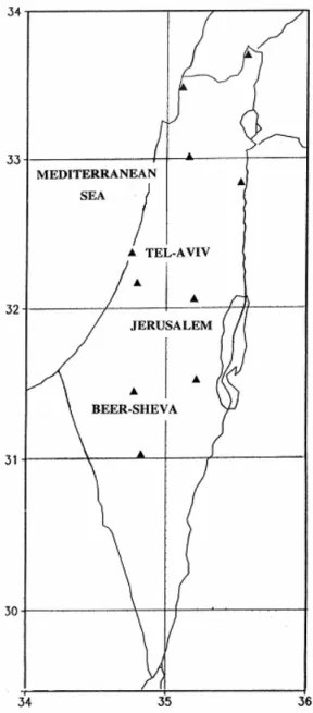
Fig. 1. Rain-measuring stations in the study region (black triangles).
The RST rain is a secondary source of the rain over Israel, especially in the southern and eastern parts of the country (Ziv, 1994; Kidron and Pick, 2000; Goldreich, 2003).
The moisture sources of the rain over Israel have been studied in several works in conjunction with synoptic situ-ations, air mass trajectory analysis or satellite infrared infor-mation (e.g., Leguy et al., 1983; Sasson, 1990; Zangvil and Druian, 1990; Sasson and Zangvil, 1994; Alpert and Shay-El, 1994; Yakir et al., 1996 and Zangvil et al., 2003). Mois-ture flux and moisMois-ture flux divergence calculation were car-ried out by Zangvil and Isakson (1995); Fengjun (2005), and Malka (2006).
The objectives of this paper are to study the differences be-tween the synoptic and humidity field characteristics of rain
situations associated with RSTs and those not connected with RSTs (non-RST rain, or NRR).
2 Data and method
The RST situations were identified objectively, based on a new, simple algorithm that was developed in our laboratory (Tsvieli and Zangvil, 2005) and applied to the NASA GEOS-1 reanalysis 6 hourly gridded data set (2◦Lat. × 2.5◦Lon)
for the period of March 1985–November 1995. This data set has been specially developed for the Mediterranean region by DaSilva and Alpert (1996). The grid data are displayed on geographical charts by the Grid Analysis and Display System (GrADS) developed by Doty (1988). Daily rainfall data from 10 representative rain-measuring stations were obtained from the Israel Meteorological Service (Fig. 1).
As described in details in Tsvieli and Zangvil (2005), we defined RST rain situations over Israel on the basis of the daily rainfall in Israel, in conjunction with the objectively defined RSTs at each map time. The rest of the map times associated with rain situations were defined as non-RST rain situation (NRR). Composite analysis of several meteorologi-cal variables was applied to the two groups of maps for each month from October to May during the period March 1985– November 1995. The results are shown in Sect. 3.
3 Results and discussion
In this Section we present results of a comparative analysis of the synoptic features of RST rain events and non RST rain events from several points of view. We start with a compari-son of sea level and 500 hPa circulation systems. Next we an-alyze the Jet stream and divergence field at the 200 hPa level, followed by a description of the moisture field and thermal structure for the two types of rain situations.
3.1 Sea level and 500 hPa circulation patterns
Examination of the sea level pressure and 500 hPa geopo-tential height charts showed remarkable differences between RST rain and non-RST rain situations. We next show repre-sentative examples of the long-term mean monthly compos-ite charts for these two categories.
Figures 2 and 3 show the main synoptic differences be-tween RST rain and non-RST rain (NRR) situations. Near the surface (Fig. 2a) NRRs are associated with a closed cy-clone centered between the island of Cyprus and the Syrian coast-line (known as the Cyprus low) and with a negative sea level pressure anomaly center over northeastern Syria, near 37.5◦N, 40◦E (Fig. 2b). The RST rains are associated
with a pronounced sea level pressure trough extending north-ward over Israel and the eastern Mediterranean (Fig. 3a), and a negative sea level pressure anomaly located near 30◦N,
40◦E (Fig. 3b).
Fig. 2. Composite charts of non-RST rain situations in January (1986–1995): (a) SLP [hPa]; (b) SLP deviation from the (1986– 1995) monthly mean; (c) 500 hPa geopotential height [m]; (d) 500 hPa height deviation from the (1986–1995) monthly mean. Ar-row denotes the width of the 500 hPa trough. Number of cases (map times) in composites for non-RST rain: 271.
The NRRs at 500 hPa are accompanied by a relatively wide trough with its meridional axis located over the Is-raeli coast-line (Fig. 2c). During RSTs rain in January the 500 hPa trough axis is located about 2.5 degrees longitude west of the Israeli coast-line (Fig. 3c), and up to about 5– 7.5 degrees west of the Israeli coast-line during the transition season months (not shown).
The 500 hPa geopotential height anomalies accompany-ing NRR (Fig. 2d) show the wide extent (about 30◦
longi-tude wide) and the relatively shallow southward penetration (only to about, 25◦N) with a negative anomaly center located
near 37◦N, 37◦E. In contrast, The RST rains are
accom-panied by relatively narrower troughs (about 20◦ longitude
wide), with relatively weak geopotential height gradients but a deeper southward penetration (to about, 15◦N) and a
neg-ative anomaly center located near 32◦N, 33◦E (Fig. 3d). We
should bear in mind that the apparent wider upper trough for the non-RST cases may reflect the variety of troughs (in both location and structure), and does not necessarily indicate that the individual troughs belonging to this class are wider. 3.2 Subtropical Jet Stream and divergence at 200 hPa At the 200 hPa pressure level we found that during NRRs the Subtropical Jet Stream core is located eastward compared to
Fig. 3. Composite charts of RST rain situations in January (1986– 1995): (a) SLP [hPa]; (b) SLP deviation from the (1986–1995) monthly mean; (c) 500 hPa geopotential height [m]; (d) 500 hPa height deviation from the (1986–1995) monthly mean. Arrow de-notes the width of the ‘500 hPa trough. Number of cases (map times) in composites for RST rain: 90.
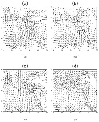
Fig. 4. Composite charts of 200 hPa wind vector deviation from the (1985–1995) monthly mean, in March: (a) non-RST rain; (b) RST rain. Arrow denotes the value of the vector scale [m/s]. Number of cases (map times) in composites for non-RST rain: 213, and for RST rain: 104.
the monthly mean (1985–1995) location, with an increase of the wind speed south or south-east of Israel (not shown). The RST rains during most of the rainy months are asso-ciated with a small decrease of wind speed over Israel (not shown). On the other hand, we found a south-southwesterly wind vector anomaly at 200 hPa over Israel during RST rains, especially in the fall and spring months, represented here
140 Y. Tsvieli and A. Zangvil: Synoptic climatological analysis of Red Sea
Fig. 5. Composite charts of 200 hPa divergence [×10−6s−1] in
March (1985–1995): (a) non-RST rain; (b) RST rain.
Fig. 6. Composite vertical profiles (1985–1995) of the moisture flux q×v, (q is the specific humidity and v is the scalar wind speed) at 32◦N, 35◦E in October, for (a) RST rain; (b) non-RST rain.
Number of cases (map times) in composites for RST rain: 141, and for non-RST rain: 61.
by the month of March (Fig. 4b) indicating a southwesterly jet stream over Israel. During NRRs a similar wind vector anomaly pattern is observed east of Israel (Fig. 4a), while over Israel a very weak anomaly prevails.
During the rainy months (represented here by the month of March) there is a clear difference in the divergence field at 200 hPa between these two rain categories. There is a diver-gence center (about 2–4×10⁻⁶/s) over, or few degrees east
of Israel during RST rains (Fig. 5b). For NRRs, a diver-gence center is observed near 45◦E (Fig. 5a). Apparently,
the upper-level dynamics does not play a role in rain forma-tion under NRR (in agreement with Kahana et al., 2002). 3.3 Moisture field
Moisture flux calculations were carried out for several atmo-spheric pressure levels (see also Zangvil and Isakson, 1995). In Fig. 6 vertical profiles of the moisture flux at the point 32◦N, 35◦E (center of Israel) associated with RST rains and
NRRs are shown for comparison. The NRRs are associated with a maximum moisture flux at 900 hPa (Fig. 6b), while
Fig. 7. Composite (1985–1995) of the moisture flux vector q×V (q is the specific humidity and V is the horizontal wind vector) at 700 hPa in October, for (a) RST rain; (b) RST rain; (c) non-RST rain, deviation from the (1985–1995) monthly mean; (d) non-RST rain, deviation from the (1985–1995) monthly mean. Arrows denote the value of the vector scale [m/s].
RST rains are associated with maximum moisture flux at 700 hPa and minimum at 900 hPa (Fig. 6a). The NRRs pro-file implies a westerly Mediterranean moisture source (the 900 hPa maximum flux may be explained by the wind speed increase with height). The weak, secondary maximum flux at 300 hPa common to both the RST and non-RST rains, Fig. 6a can be explained by the presence of the Subtropical Jet Stream at that level.
The maximum moisture flux at 700 hPa associated with RST rains (Fig. 6a) is most pronounced during the transition seasons, but exists also during the winter months. The sec-ondary maximum at 950 hPa can be explained by the north-westerly maritime flow near the surface associated with the RST (Fig. 3c).
Figures 7, 8 show the moisture flux vector (q×V ) at 700 and 900 hPa, respectively, during RST rains and NRRs. During NRRs there is pronounce north-westerly moisture flux vector both at 700 hPa (Figs. 7a, c) and at 900 hPa (Figs. 8a, c), implying an immediate moisture transport from the Mediterranean, in agreement with Zangvil and Druian (1990) and Zangvil et al. (2003).
Fig. 8. Same as Fig. 7, but for 900 hPa.
During RST rains there is northward moisture flux from the southern Red Sea along 40◦E at 900 hPa, implying
mois-ture transport from the Indian Ocean or the Arabian Sea (Fig. 8b). This flux is related to the prevailing near-surface flows at the eastern part of the RST (Fig. 3a). Figure 8d shows that these flows turn back over Turkey and arrive as north-westerly flows and moisture flux from the EM into Israel. At 700 hPa, the level of maximum moisture flux, (Fig. 6a) there is a pronounced south-westerly moisture flux from equatorial Africa to Israel and vicinity (Figs. 7b and d). In spring when the land-sea temperature differences are large and the sea breeze with its west to northwesterly mar-itime winds is active during the day, the moisture entering the country may play some role in the development of con-vective storms over the eastern parts of the country. Near the coast the relatively cool sea breeze air may have a stabilizing effect.
The difference in 700 hPa moisture flux between RST rains and NRRs is well correlated with the upper trough structure and position differences between these two rain-fall categories, as described in Sect. 3.1. The western posi-tion and the relatively deep southward penetraposi-tion of the up-per trough accompanying RST rains, causes south-westerly moisture flux transported by the flow ahead of the trough. During NRRs the upper trough axis is located over Israel, causing north-westerly moisture flux at the rear of the trough.
Fig. 9. Vertical profiles of temperature deviations from the time mean (1985–1995) at 32◦N, 35◦E in November, for (a) RST rain;
(b) non-RST rain. Number of cases (map times) in composites for RST rain: 111, and for non-RST rain: 150.
3.4 Vertical temperature profile
Figure 9 shows the vertical temperature profile at 32◦N,
35◦E associated with RST rains and NRRs. In order to
emphasize the differences between these two categories, the temperature values are presented as the deviation from the long-term monthly mean.
In RST rains there are positive temperature anomalies near the surface, changing to negative above 800 hPa (Fig. 9a). The positive temperature anomalies near the surface result from warm advection by the southeasterly flows associated with the RST. On the other hand, the upper trough that accompanies RST rains may explain the negative tempera-ture anomalies in the 800–300 hPa layer. The temperatempera-ture anomalies in the 300–100 hPa layer are most likely related to changes in tropopause height. In RST rains the positive anomalies above 300–200 hPa are related to the cooling un-der this layer, which are also reducing the tropopause height. The 300–100 hPa layer is probably located at the lower part of the stratosphere in which the temperature normally in-creases with height.
In NRRs there is a negative temperature anomaly from the surface up to about, 300 hPa, where it changes to a posi-tive anomaly (Fig. 9b), controlled by changes in tropopause height, as explained before. During NRRs the negative anomalies are larger by, up to 2.5◦C (near the surface)
com-pared to RST rains. This difference reflects the southwesterly flow aloft, accompanied by winds from the easterly quadrant near the surface associated with RST rains. These flows are warmer than the northwesterly upper flow associated with NRRs.
Figure 9 shows that the temperature lapse-rate between the surface and 500 hPa is steeper during RST rains com-pared with the NRRs, enhancing unstable atmosphere condi-tions during RST rains. During NRRs there is strong cool-ing throughout the troposphere with a maximum coolcool-ing near 700 hPa, while during RST rains a steeper lapse-rate occurs, resulting from some cooling between 750 to 350 hPa and pro-nounced heating near the surface.
142 Y. Tsvieli and A. Zangvil: Synoptic climatological analysis of Red Sea
4 Summary and conclusions
This paper presents results of synoptic climatological com-parative analysis between rain situations associated with RST, and those not connected with RST (non-RST rain, NRR). The RST situations were identified objectively by a new, simple algorithm applied to the NASA GEOS-1 reanal-ysis 6- hourly gridded data set (2◦Lat. × 2.5◦Lon) for the
period of March 1985–November 1995. The RST rain sit-uations over Israel were defined on the basis of daily rain-fall data in Israel in conjunction with the objectively defined RSTs.
Results show that near the surface NRRs are associated with a closed cyclone located over the Syrian coast-line or further east, over northern Syria, and with a negative sea level pressure anomaly center over northeastern Syria, near 37.5◦N, 40◦E. The RST rains are associated with a sea level
pressure trough extending northward over Israel and the east-ern Mediterranean, the Red Sea Trough, and a negative sea level pressure anomaly near 30◦N, 40◦E.
Although both types of rain situations are associated with 500 hPa cold troughs there are pronounced differences in the structure and location of the troughs. The RST rain is ac-companied by a mean, relatively narrow trough (about 20◦
longitude in width), located 2.5◦ longitude west of the
Is-raeli coast-line (up to about 5–7.5 degrees during the tran-sition season months) and characterized by a relatively deep southward penetration, to about 15◦N. On the other hand,
NRR is accompanied by a wider upper trough (about 30◦
width), located over the Israeli coast-line but with a shallower southward penetration, only to about 25◦N. As mentioned in
Sect. 3.1 we should bear in mind that the apparent wider up-per trough for the non-RST cases may reflect the variety of troughs and does not necessarily indicate that the individual troughs belonging to this class are wider.
We found a south-southwesterly wind vector anomaly at 200 hPa over Israel during RST rains, especially in the fall and spring months, while during NRRs a similar wind vector anomaly pattern is observed east of Israel, and a very weak anomaly prevails over Israel. We also found a marked differ-ence in the divergdiffer-ence field at 200 hPa between these two rain categories: There is a divergence center (about 2–4×10⁻⁶/s)
over, or few degrees east of Israel during RST rains. For NRRs, a divergence value of about 0 is observed over Israel with a divergence center located east of Israel, near 32◦N,
47◦E.
The vertical profiles of moisture flux, q×v, near the cen-ter of Israel show that NRRs are associated with a maximum moisture flux at 900 hPa, while RST rains are associated with maximum moisture flux at 700 hPa (most pronounced during the transition seasons) and a minimum at 900 hPa. During NRRs there is a pronounced west to north-westerly mois-ture flux vector both at 700 hPa and at 900 hPa, implying an immediate moisture source from the Mediterranean. Dur-ing RST rain situations two moisture sources may be
oper-ating: 1. Equatorial Africa and/or the Indian Ocean by the southwesterly 700 hPa mid-tropospheric flow. 2. The EM by the west-northwesterly flow near the surface. More re-search in needed to assess the exact partition of the water vapor in the rainfall, between these two moisture sources. The westerly position and the relatively deep southward pen-etration of the upper trough accompanying RST rains, may explain the moisture transported by the southwesterly flow ahead of the trough. On the other hand, prior to NNRs the upper trough does not penetrate southward enough to draw tropical moisture ahead of the upper trough. During NRRs the upper trough axis is located over Israel, causing Mediter-ranean westerly to north-westerly moisture flux at the rear of the trough.
In RST rains there are positive temperature anomalies near the surface, changing to negative near 900–800 hPa, while in NRRs there is a negative temperature anomaly from the sur-face up to about, 300 hPa. During NRRs the negative anoma-lies were found to be larger by up to 2.5◦C compared to RST
rains. This difference reflects the southwesterly flow aloft associated with RST rains, which is warmer than the west to northwesterly upper flow associated with NRRs. Still, a steeper temperature lapse-rate was found during RST rain compared with NRR enhancing unstable atmospheric con-ditions during these rains.
Finally, the reason why an RST develops ahead of shallow upper troughs is that these troughs are displaced to the south and thus instead of generating the usual Cyprus low they gen-erate a low a few hundred km to the south of Cyprus. This low pressure system may not assume a circular shape of a closed low since it tends to merge with the semi-permanent quasi-stationary RST (see also, Karas and Zangvil, 1999) having an orographic and or thermal origin. Because of its southerly displacement, this synoptic system is able to draw moisture from tropical origins and thus the warm sector of the surface low (or RST) may become moister than the usual, non RST rain bearing trough. As a result, warm sector or warm frontal-like showers and thunderstorm activity may de-velop. This is the main difference between the RST rain and the non RST or usual winter rain in Israel.
Acknowledgements. The reanalysis data was made available to
us by ISA-MEIDA, Tel Aviv University. Daily rain data from 10 stations over Israel were obtained from the Israel Meteorological Service. Thanks are due to anonymous reviewers for helpful comments and to D. Klepach for his assistance in programming. Edited by: P. Alpert, H. Saaroni, and E. Heifetz
Reviewed by: two anonymous referees
References
Air Ministry, Meteorological Office: Weather in the Mediterranean, Vol. I, London, HMSO, 362 pp., 1962.
Alpert, P. and Shay-El, Y.: The moisture source for the winter cy-clones in the Eastern Mediterranean, Israel Meteorological Re-search Papers, 5, 20–27, 1994.
DaSilva, A. and Alpert, P.: Documentation of the multi-year GEOS-1 assimilation data subset for Northern Africa, the Mediterranean and the Middle East. NASA, Goddard Space Flight Center, DAO Office Note 96-05, 24 pp., Feb. 1996.
Dayan, U. and Sharon, D.: Meteorological parameters for discrimi-nation between widespread and spotty storms in the Negev, Israel J. Earth Sci., 29, 253–256, 1980.
Doty, B. E.: Grid Analysis and Display System (GrADS), Center for Ocean-Land-Atmosphere Interaction, Institute for Global En-vironment and Society, Calverton, MD, 1988.
Fengjun, J.: The connection between water vapor budget compo-nents and rainfall in the Eastern Mediterranean, M.S. Thesis, Blaustein International School for Desert Studies, Ben Gurion University, 63 pp., 2005.
Goldreich, Y.: The Climate of Israel: Observation, Research and Applications, Kluwer Academic/Plenum Publishers, New York, 298 pp., 2003.
Itzigsohn, D.: Dynamical and climatological analysis of interac-tions between the tropics and mid-latitudes in the Red Sea area, MSc Thesis, Department of Geophysics and Planetary Sciences, Tel Aviv University (in Hebrew), 137 pp., 1995.
Kahana, R., Ziv, B., Enzel, Y., and Dayan, U.: Synoptic climatology of major floods in the Negev Desert, Israel, Int. J. Climatol., 22, 867–882, 2002.
Karas, S. and Zangvil, A.:. A preliminary analysis of disturbance tracks over the Mediterranean Basin, Theor. Appl. Climatol., 64, 239–248, 1999.
Kidron, G. J. and Pick, K.: The limited role of localized convec-tive storms in runoff production in the western Negev Desert, J. Hydrol., 229, 281–289, 2000.
Krichak, S. O, Alpert, P., and Krishnamurti, T. N.: Interaction of topography and tropospheric flow – a possible generator for the Red Sea Trough?, Meteorol. Atmos. Phys., 63(3–4), 149–158, 1997a.
Krichak, S. O., Alpert, P., and Krishnamurti, T. N.: Red Sea Trough/cyclone development – numerical investigation, Meteo-rol. Atmos. Phys., 63(3–4), 159–169, 1997b.
Leguy, C., Rindsberger, M., Zangvil, A., Issar, A., and Gat, J. R.: The relation between the oxygen-18 and deuterium contents of rainwater in the Negev desert and air mass trajectories, Chem. Geol. (Isotope Geoscience Sec.), 1, 205–218, 1983.
Malka, S.: Analysis of the water vapor field and synoptic charac-teristics in relation to temporal and regional variation of precip-itation in Israel, M.S. Thesis, Blaustein International School for Desert Studies, Ben Gurion University, 99 pp., 2006 (in Hebrew). Saaroni, H., Ziv, B., Bitan, A., and Alpert, P.: Easterly wind storms
over Israel, Theor. Appl. Climatol., 59, 61–77, 1998.
Sasson, A.: Connection between synoptic characteristics and at-mospheric moisture field and major rain storms over Israel, Mas-ters Thesis, Dept of Geography and Institute for Desert Research, Ben Gurion University, 115 pp., 1990 (in Hebrew).
Sasson, A. and Zangvil, A.: Preliminary report on the connec-tion between the atmospheric moisture field measured by the METEOSAT-2 satellite and precipitation in Israel, Israel Mete-orological Research Papers, 5, 79–82, 1994.
Tsvieli, Y. and Zangvil, A.: Synoptic climatological analysis of “wet” and “dry” Red Sea Troughs over Israel, Int. J. Climatol., 25, 1997–2015, 2005.
Tsvieli, Y.: Synoptic climatological analysis of “wet” and “dry” Red Sea Troughs over Israelm Ph.D thesis, Department of Geog-raphy and Environmental Development, Ben-Gurion University of the Negev, Israel, 98 pp., 2006 (in Hebrew).
Yakir, D., Lev-Yadun, S, and Zangvil, A.: El Nino and tree growth near Jerusalem over the last 20 yearsm Global Change Biol., 2, 97–101, 1996.
Zangvil, A. and Shemer, D.: The climate of the Negev, in: At-las of the Negev, edited by: Stern, E., Gradus, Y., Meir, A., Krakover, S., and Tsoar, H., Department of Geography, and the Blaustein Institute for Desert Research, Ben-Gurion University of the Negev, Beer-Sheva, 1986 (in Hebrew).
Zangvil, A. and Druian, P.: Upper air trough axis orientation and the spatial distribution of rainfall over Israel, Int. J. Climatol., 10, 57–62, 1990.
Zangvil, A. and Isakson, A.: Structure of the water vapor field as-sociated with an early spring rainstorm over the eastern Mediter-ranean, Israel J. Earth Sci., 44, 159–168, 1995.
Zangvil, A., Karas, S., and Sasson, A.: Connection between East-ern Mediterranean seasonal mean 500 hPa height and sea-level pressure patterns and the spatial rainfall distribution over Israel, Int. J. Climatol., 23, 1567–1576, 2003.
Ziv, B.: The weather in Israel, in: Introduction to Meteorology, edited by: Ziv, B., and Yair, Y., The Open University Press, Tel Aviv, Israel, Unit 5, 8–59, 1994 (in Hebrew).
![Fig. 2. Composite charts of non-RST rain situations in January (1986–1995): (a) SLP [hPa]; (b) SLP deviation from the (1986–](https://thumb-eu.123doks.com/thumbv2/123doknet/14761143.585208/4.892.468.815.94.488/fig-composite-charts-rst-rain-situations-january-deviation.webp)
![Fig. 5. Composite charts of 200 hPa divergence [×10 − 6 s − 1 ] in March (1985–1995): (a) non-RST rain; (b) RST rain.](https://thumb-eu.123doks.com/thumbv2/123doknet/14761143.585208/5.892.463.815.98.528/fig-composite-charts-divergence-march-rst-rain-rst.webp)