Dissecting the Eastern Margin of the Tibetan Plateau:
A Study of Landslides, Erosion and River Incision in a Transient
Landscape
by
William Burke Ouimet
B.A., Geosciences and Mathematics, Williams College (2001)
Submitted to the Department of Earth, Atmospheric, and Planetary Science, in partial fulfillment of the requirements for the degree of
Doctor of Philosophy
at the
MASSACHUSETTS INSTITUTE OF TECHNOLOGY September 2007
© 2007 Massachusetts Institute of Technology. All rights reserved.
Signature of Author:
Geology, Department of Earth, Atmospheric, and Planetary Science
August 2 8th, 2007 Certified by: Kelin X Whipple, PhD Professor of Geology Thesis Supervisor Certified by Leigh H. Royden, PhD Professor of Geology and Geophysics Thesis Supervisor
Accepted by:
IASSACH
_OF.Tso.Not.oe',
U INSTITUJ . -S''OCT 2 2 2007
LIBRARIES
Maria T. Zuber, PhD E.A. Griswold Professor of Geophysics Head, Department of Earth, Atmospheric & Planetary Science
ARCHNES
V"~~ rr r -- -- v-I I 2F ..I"
v
r:Dissecting the Eastern Margin of the Tibetan Plateau:
A Study of Landslides, Erosion and River Incision in a Transient
Landscape
by
William Burke Ouimet
Submitted to the Department of Earth, Atmospheric, and Planetary Science on Aug. 28th, 2007 in partial fulfillment of the requirements for the degree of
Doctor of Philosophy
ABSTRACT
The eastern margin of the Tibetan plateau is characterized by large rivers dissecting regional topography that has been uplifted in association with the continued convergence of
the Indian subcontinent and Eurasia. In this thesis, I utilize field observations, digital topographic data, cosmogenic isotope data, low-temperature thermochronology and
numerical simulations to better understand the evolution of these rivers and tectonics of the region. The goals of this work are: 1) to characterize the rates and processes of river incision
and erosion associated with major rivers dissecting the eastern margin; 2) to better
understand and constrain the transient landscape evolution that defines regional topography; and 3) to move closer to understanding the relationships among tectonics, topography and erosion that apply directly to the eastern margin, and may be applied to other landscapes around the world.
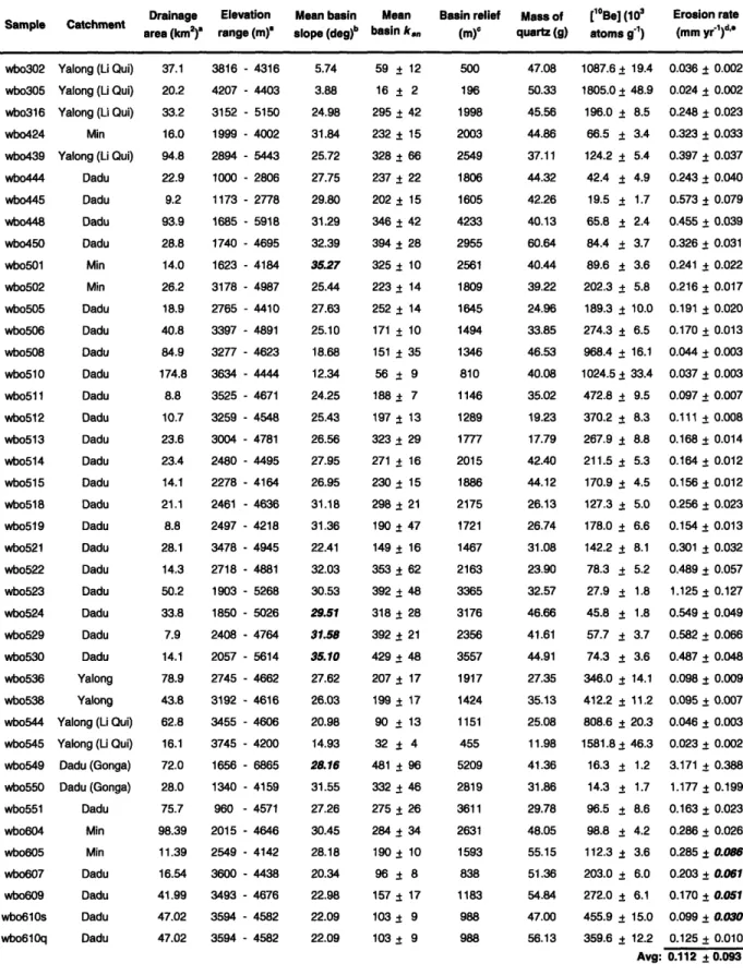
To accomplish these goals, I study the rates and processes of river incision and erosion on the eastern margin on a variety of spatial and temporal scales. I discuss local incision processes and related landforms by exploring the influence of large landslides and discussing epigenetic gorges, which are secondary bedrock-walled channels that form in relation to episodes of river blockage or afgradation. I quantify short-term (102-105 yr) erosion rates using cosmogenic isotopes ( Be) from river sand for 65 small river basins (typically <100 km2) throughout the eastern margin, and long-term (106-107 yr) incision rates using low-temperature thermochronology from elevation transects collected within the Dadu, Yalong, and Yangtze river gorges. Each short-term, basin-averaged erosion rate represents erosion for a unique subset of eastern margin topography, lying within the context of the large-scale transient morphology of the region; while the long-term incision rates quantify the onset and rates of rapid incision associated with regional scale river response to plateau uplift. All of these datasets combine to provide a valuable example of a large, actively evolving transient river with spatially variable erosion and incision, from which can be drawn implications for regional tectonics and models of river incision and landscape evolution, in general.
Thesis Supervisors: Kelin X Whipple, Professor of Geology
Acknowledgements
Let me begin by acknowledging the funding that facilitated my thesis research - the National Science Foundation Continental Dynamics Program Grant EAR-0003571. I want to give special thanks to my research advisors: Kelin Whipple and Leigh (Wiki) Royden.
Thank you for giving me the opportunities that you have and for all of your support, encouragement, guidance, inspiration and friendship over the last 5 years. I also want to thank Darryl Granger and Noah Snyder, the other members of my thesis committee, for their guidance and help with my thesis research; and similarly, Clark Burchfiel, David Mohrig and Kip Hodges, who were all members of my thesis committee at one time. Special thanks are also necessary to a number of people who made field work in China possible, namely our colleagues and drivers at the Chengdu Institute of Geology and Mineral Resources (Fawei Tang, Zhiming Sun, Zhiliang Chen and Guoxia Miu), and our field assistants who were crucial for ensuring our safety and sanity in the field and with whom I shared many
memorable Chinese experiences (Joel Johnson, Jamon Frostenson and Kyle Bradley). Parts of this thesis were completed in collaboration with a number of colleagues and I wish to thank them for their guidance and involvement in my research, this includes: Malcolm Pringle, Pete Reiners, Stefan Nicolescu, Shannon Mahon, Daniel Sheehan, Tom Clifton, Marc Caffee, Andy Cyr, Nicole Gasparini, Ben Crosby, Taylor Schildgen and Joel Johnson. Finally, I wish to thank Roberta B.C., Vicki M., Carol S., Carol Z., Pat W., Jackie, Roberta A. and the rest of the 9t floor gang for their always helpful and cheerful administrative and logistical support.
Numerous people who were not directly related to my thesis have also influenced my time in Boston and at MIT over these last 5 years. There are too many to remember so please forgive me if I have forgotten anyone. I would like to broadly thank all the students in the EAPS community, whose friendship, enthusiasm, encouragement and example inspired and motivated my time in the department. I especially would like to acknowledge the older graduate students who provided me with wonderful mentorship and amazing encouragement in life and research (Ben C., Cam W., Lindsay S., Chris S.G., Marin C., Simon B., Kate R., Bill L., Maureen L., and Sinan A.). I also want to thank Kyle S. for being my closest friend
and companion throughout the entire thesis process, and the many other students who I have had to pleasure of interacting with on a regular basis and who I will always remember fondly
from my time at MIT (Taylor S., Joel J., Kristen C., Ryan C., Danny M., Einat L., Blair S., Kyle B., Sarah S.J., Doug J., Wes W., Jon W., and Dave F.). Whether it was for fellow
geomorphologic and tectonic inspiration and guidance, east Tibet camaraderie, 8th floor friendship, or research feedback, these friends have provided me with an invaluable support network. Thanks also to post-doc/lecturers Scott M. and Manny V. for great research discussions and wonderful friendships. Outside of the department, there are a number of people to whom I'd like to give a BIG thank you for their support, encouragement and friendship and to whom I must bid farewell: the entire Baker House community, members of Kinaesthetics Lab, the Muddy Charles gang, the Graduate Soccer Club, and various softball teams...just to name a few.
Finally, I would like to thank my wife and best friend, Elle. None of this would have been possible without the love, support and guidance you have given me over the last 5 years. I look forward to seeing where our path leads next and sharing every moment with you. I would also like to thank my closest friends (Kyle S., Chris K., Rees H., Todd R.) and the rest of my family (my parents [Jack and Anne], Holly, Jake, Rick, Abby, Max, Rose, Alison, Joe, Olivia, baby Elle, Annie, Lisa, Steven, Lizzie, and Beulah) for continually supporting me in all my endeavors and for their love, enthusiasm, and curiosity.
PS -Very special thank you to Kelin for letting me use his satellite phone in the field,
without it I would not have been able to follow the Red Sox finally winning the World Series in October of 2004, during which I was in China for field work. And yes, thank you to the Red Sox for finally winning a World Series!
Table of Contents
Introduction ... 9
The Influence of Large Landslides on River Incision in a Transient Landscape: Eastern Margin of the Tibetan
Plateau (Sichuan, China) ... ...
* Chapter 2 Appendix ... ... 57
Epigenetic Gorges in Fluvial Landscapes ... 73
Erosion Rates and Topography on the Eastern Margin
of the Tibetan Plateau ... 103 * Chapter 4 Appendix ... 117
New Constraints on Timing and Rates of Plateau Uplift Recorded by Incision of Major River Gorges on the
Eastern Margin of the Tibetan Plateau ... 129
Dissecting the Eastern Margin of the Tibetan Plateau:
Transient River Response to Regional Uplift ... 157
Conclusions and Implications ... 194
Chapter 1: Chapter 2: Chapter 3: Chapter 4: Chapter 5: Chapter 6: Chapter 7.
I am among those who think that science has great beauty. A scientist in his laboratory is
not only a technician: he is also a child placed before natural phenomena which impress him
like a fairy tale.
Chapter 1 - Introduction
Chapter 1
Introduction
The eastern margin of the Tibetan plateau has some the world's deepest river gorges. However, the deeply dissected, high-relief terrain that characterizes these gorges is juxtaposed against un-dissected, low-relief, low-slope remnants of topography thought to represent the pre-uplift or relict landscape of the region (Clark et al., 2006). These topographic extremes highlight the diversity of landscapes that can be found in this setting. They also speak to most salient aspect of landscape evolution in the region: river incision and landscape adjustment are
incomplete, or transient. Remnants of relict topography only persist because the region's largest rivers have only just begun, relatively speaking, to dissect the plateau, and they are likely to continue doing so for millions of year to come. For this reason, I argue, the eastern margin is one of the most ideal settings in which to study active, large-scale transient landscape evolution.
The main objectives of this thesis are 1) to characterize the rates and processes of river incision and erosion associated with major rivers dissecting the eastern margin; 2) to better understand and constrain the transient landscape evolution that defines regional topography; and
3) to move closer to understanding relationships among tectonics, topography and erosion that
apply directly to the eastern margin, and may be portable to other landscapes around the world. The approach is to combine field observations, digital topographic data, cosmogenic isotope data, low-temperature thermochronology and numerical simulations to better understand the evolution of these rivers. This multi-disciplinary approach allows for the characterization of the spatial distribution of erosion and river incision at a range of temporal and spatial scales, and for the acquisition of information about the relative roles of important surface processes.
Altogether, these aspects are crucial for developing geodynamic models that explore the tectonic history and landscape evolution of the entire eastern margin of the Tibetan plateau, as well as for lending insight into such processes in other locations around the world.
Background
Recent topographic analyses have yielded valuable insights into the geodynamic evolution of the eastern margin and its diverse landscapes. The foundation of this thesis is a
Chapter 1 - Introduction
group of studies that identified and characterized the relict topography throughout the region and used it to constrain regional deformation, surface uplift and the initiation of river incision
throughout the Dadu and Yalong River drainages (Clark et al., 2005a; Clark et al., 2005b; Clark et al., 2006). Much of my work is aimed at characterizing and better constraining river response to the uplift and deformation developed in these studies. I also build off of studies that highlight the utility of topographic analyses to constrain local tectonic and climatic controls on rates of bedrock river incision and landscape evolution in other rivers in the region. These include studies that use river profiles to: (1) constrain surface uplift and phases of river incision along the Red River in southern Yunnan Province (Schoenbohm et al., 2004); (2) determine relative rates of rock uplift to the north of the Sichuan Basin within the Min River drainage (Kirby et al., 2003); and (3) analyze patterns and controls on fluvial incision in the upper reaches of the Yellow River (Harkins et al., 2007).
The above studies also fit more broadly into research aiming to better understand feedbacks among topography, the rate and style of tectonic deformation, climate and surface processes and erosion (e.g., Willett, 1999; Beaumont et al., 2001; Whipple and Meade, 2004). The recognition of these feedbacks has driven research into quantifying how landscapes respond to changes in local or regional tectonic forcing, base-level fall or climate. Classically, these
studies have relied on steady-state formulations and discussions of equilibrium river profiles (Hack, 1957; Howard, 1994; Whipple and Tucker, 1999). More recently, however, transient landscapes that are actively adjusting to a change in one of these external forcings have been recognized to offer the opportunity to test and improve incision models that have similar equilibrium forms (Stock and Montgomery, 1999; Whipple and Tucker, 2002; van der Beek et al., 2003; Whipple, 2004; Crosby et al., 2007; Gasparini et al., 2006; Gasparini et al., 2007). Because the landscape of the eastern margin of the Tibetan plateau is one of the broadest, most
dramatic examples of a transient landscape anywhere on earth, it provides the unique opportunity to study models of river incision and large-scale response to regional tectonic forcing.
Chapters 2-7
The chapters in this thesis summarize my efforts to better understand the processes, rates and landforms involved in landscape erosion and transient river incision within the major river gorges of the eastern margin of the Tibetan plateau. The study area lies to the east of the Eastern
Chapter 1 - Introduction
Himalayan Syntaxis and to the west of the Sichuan Basin in western Sichuan. This broad region is dissected by three of Asia's largest rivers: the Yangtze, Mekong and Salween. The focus of my analysis is on two of the Yangtze River's largest tributaries, the Dadu and Yalong, which lie east of the Eastern Himalayan Syntaxis and directly to the west of the Sichuan Basin. I also include a limited degree of analysis in the Min river drainage to the east of the Dadu river and north of the Sichuan Basin and within the Yangtze gorge itself, west of Yalong river.
Chapter 2 explores the influence of large landslides on river incision in a transient landscape. Large landslides are a prominent feature of hillslope erosion in steep, actively incising landscapes like the eastern margin, yet few models of bedrock river incision and landscape evolution allow for dynamic feedbacks between river incision and the influence of large landslides. My study of large landslides in the region came about as I was looking for evidence of active river incision (strath terraces, etc.) in the Dadu river gorge. Time and time again the landforms I was observing in the valley were identified as being related to large landslides and landslide dams, and as a result I began to consider their influence on river incision. Chapter 2 is the synthesis of this work to understand the role of landslides in the incision of eastern margin gorges. I report on examples from my fieldwork which highlight the
interaction among landslide dams, channel morphology, longitudinal river profiles, and river incision. I then use these examples to motivate and formulate a simple, probabilistic, numerical model which provides a quantitative framework for evaluating how landslides influence long-term river incision and landscapes in general. One of the relevant results of this chapter is that landslide effects are studied as a by-product of transient adjustment initiated by regional uplift and rapid incision. However, over timescales relevant to landscape evolution (>104 yr), large
landslides can also act as a primary control on channel morphology and longitudinal river profiles, inhibiting incision and further preventing the complete adjustment of rivers to regional tectonic, climatic and lithologic forcing.
Chapter 3 discusses a landform that I identified in river gorges on the eastern margin that is related to large landslides and landslide dams. The landform in question is called an
epigenetic gorge, defined as a bedrock-walled river channel segment that forms as rivers incise into valley-filling deposits and become superimposed on bedrock spurs or entrenched into side-walls of the former valley. My identification of epigenetic gorges on the eastern margin sparked their identification in the field areas of other MIT students working within actively incising
Chapter 1 - Introduction
landscapes. Chapter 3 summarizes these findings and highlights the prevalence of epigenetic gorges in actively incising fluvial landscapes around the world. I introduce conceptual models for the formation of epigenetic gorges in relation to landslides and fluvial aggradation and
support these models with examples from rivers that drain the eastern margin of the Tibetan Plateau, the Peruvian Andes, the Colorado Plateau, and the North Island of New Zealand. I then use these examples to discuss the dynamics involved in epigenetic gorge formation, as well as explore their significance and implications in the context of studying the rates and processes of bedrock river incision and landscape evolution. Both epigenetic gorges and the influence of
landslides are indicative of the variability of short-term bedrock river incision and autogenic dynamics of actively incising fluvial landscapes. And a result, strath terraces and sculpted bedrock walls that form in relation to epigenetic gorges and landslide dams should not be used to
directly infer river incision induced by tectonic activity or climate variability.
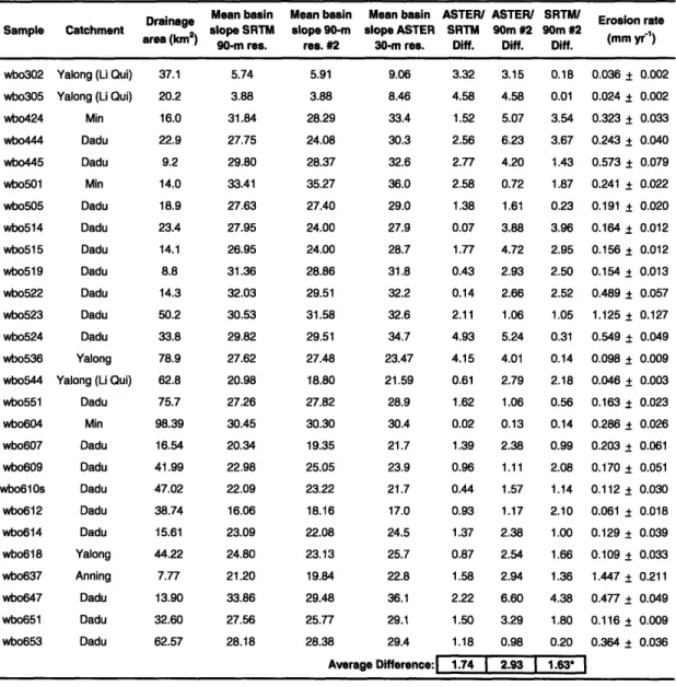
In chapter 4, I utilize cosmogenic isotopes (10Be) from river sand to systematically explore the rates and patterns of short-term (102-105 yr) basin-wide erosion on the eastern margin. These erosion rates allow us (1) to fully characterize the differential rates of erosion associated with the relict landscape and incised gorges (and all topographic morphologies in between), (2) to compare short-term erosion rates with long-term rates from thermochronology, and (3) to investigate spatial patterns of erosion related to regional uplift and transient river incision. Chapters 5 and 6 include a discussion of my short-term erosion rates in these contexts. In chapter 4, however, I more broadly use my results to develop functional relationships between topography and erosion, providing the most comprehensive, direct quantification to date of fundamental relationships between topography and erosion in a single landscape with relatively uniform tectonics, climate and lithology. Specifically, I relate my erosion rates to three measures of landscape topography: hillslope angle, normalized river channel gradient, and relief. The unique setting of the eastern margin allows us to cover the majority of the globally known ranges for these topographic metrics while the regional erosion rates appear to range over two orders of magnitude. These relationships offer valuable insight into erosional processes on hillslopes and in river channels, their controlling variables, and their rates. The details of my results are specific to my study site, but the patterns are expected to be robust and applicable to landscapes around the world. One of the relevant results of this study is that mean basin slopes reach maximum values and become insensitive to further increases in the erosion rate above -0.25
Chapter 1 - Introduction mm/yr, thus marking a transition in dominant hillslope erosion to landslides that is possibly set by the near-surface soil production rate (Heimsath et al., 1999). At erosion rates >0.25 mm/yr, meanwhile, channel steepness (and relief) is a more sensitive indicator of erosion.
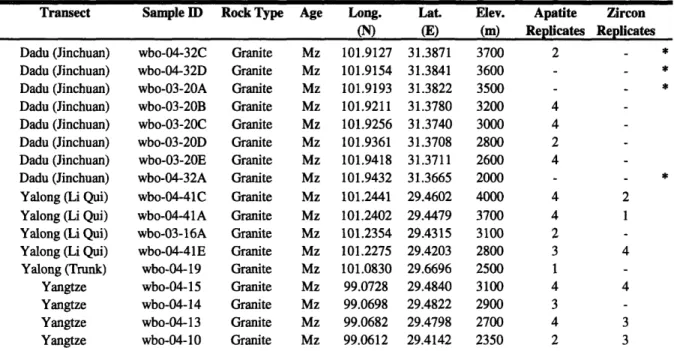
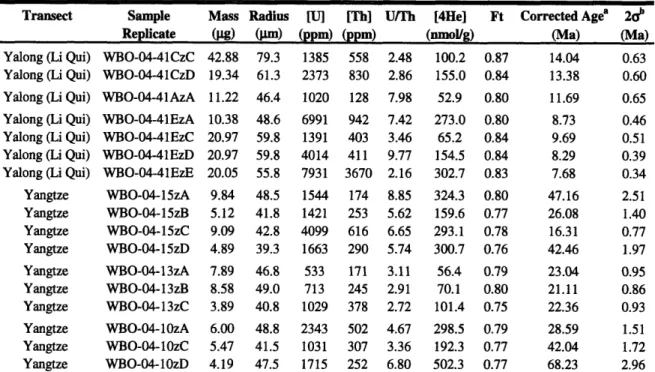
Chapter 5 provides new constraints on the timing and rates of plateau uplift recorded by the long-term incision of major river gorges. Specifically, I utilize low-temperature
thermochronology to explore late Cenozoic incision history. I present new (U-Th)/He analyses from age-elevation transects collected within the Dadu, Yalong and Yangtze River gorges on the eastern margin of the Tibetan Plateau. I build on the earlier work of Clark et al. (2005) by testing the hypothesis of synchronous regional uplift and refining their estimates of the timing of the onset of rapid incision in the Dadu river gorge, as well as better developing the picture of regional long-term erosion rates and constraints on incision for the other major rivers. I also include in my analysis a comparison of long-term erosion rates with short-term rates presented in chapter 4. Together, all these data provide valuable constraints on geodynamic models that explore the late Cenozoic evolution of entire eastern margin (i.e., how uplift progressed). The more relevant results of this study are that river gorges on the eastern margin of the Tibetan Plateau exhibit consistent long-term (106-107 yr) erosion rates between 0.3 and 0.4 km/Ma for at least the last 10 Ma, and that variations in the amount of exhumation and timing of rapid incision
suggest that significant variability may exist in the broad response of the large rivers dissecting the margin.
Chapter 6 provides an overall discussion of the dissection of the eastern margin of the Tibetan plateau and river response to regional uplift. Specifically, I utilize longitudinal profiles and topographic analysis to investigate controls on the spatial distribution of erosion and river incision on the eastern margin, focusing on a systematic analysis of major trunk rivers in the Dadu river drainage. The longitudinal profiles of these trunk rivers start at high elevations over 4000m where they run on the relict landscape (or are slightly incised into it) and gradually transition into deep gorges characterized by high-relief and steep hillslopes. Thus, as they flow downstream these rivers are increasingly incised below the relict landscape. I analyze trunk river gradients as well as the gradients, hillslopes and relief characteristics of side tributaries
systematically moving downstream, adjacent to trunk rivers, to quantify this dissection of topography. I also combine this analysis with my short and long-term erosion rates from chapters 4 and 5 to evaluate longitudinal variations in incision and erosion rate. The eastern
Chapter 1 - Introduction
margin ends up providing a valuable example of a large, actively evolving transient landscape with spatially variable erosion and river incision. Interesting results from this chapter include the agreement of erosion rates calculated over different timescales in the context of transient river incision.
Finally, chapter 7 summarizes the major conclusions of the thesis and discusses the implications of the work. I include in this summary and discussion topics specific to the landscape and geodynamic evolution of the eastern margin of the Tibetan Plateau, as well as broader implications for the way the earth's surface responds and evolves in relation to tectonic, climate and lithologic forcing. I characterize my work on the eastern margin as a case study on landslides, erosion and river incision in a transient landscape.
Publication Information
Chapters 2-6 were prepared as manuscripts to be submitted for publication as individual journal articles. As a result, there is a certain amount of unavoidable overlap in the introductory
material and content, in general, of these chapters. Chapter 2 is in press at the Geological
Society of American Bulletin due for publication in fall 2007. Chapter 3 is currently in review at
Earth Surface Processes and Landforms. Chapter 4 is currently in review at Geology. Chapter 5
was prepared for submission to Earth and Planetary Science Letters and will be submitted in fall 2007 after additional analyses are run. Chapter 6 was prepared for submission to Journal of
Geophysical Research - Earth Surface; and will be submitted in fall 2007. Although the
formatting of Chapter 2 was changed in order to maintain consistent formatting within this thesis, the content of Chapter 2 is identical to that found in published versions.
REFERENCES
Beaumont, C., R. A. Jamieson, M. H. Nguyen, and B. Lee, 2001, Himalayan tectonics explained by extrusion of a low-viscosity crustal channel coupled to focused surface denudation, Nature, 414, 738- 742.
Clark, M.K., House, M.A., Royden, L.H., Whipple, K.X., Burchfiel, B.C., Zhang, X., and Tang, W., 2005, Late Cenozoic uplift of southeastern Tibet, Geology, vol. 33, no. 6, pp. 525-528. Clark, M. K., J. W. M. Bush, and L. H. Royden, 2005, Dynamic topography produced by lower
crustal flow against rheologic strength heterogeneities bordering the Tibetan Plateau, Geophys. J. Int., 162, 575-590.
Chapter 1 - Introduction Clark, M.K., Royden, L.H., Whipple, K.X., Burchfiel, B.C., Zhang, X., and Tang, W., 2006, Use
of a regional, relict landscape to measure vertical deformation of the eastern Tibetan Plateau, Journal of Geophysical Research, 111, F03002, doi: 10. 1029/2005JF000294.
Crosby, B.T., Whipple, K.X., Gasparini, N.M., and Wobus, C.W., 2007, Formation of fluvial hanging valleys: theory and simulation, JGR Earth Surface, vol. 112, F03S 10,
doi: 10. 1029/2006JF000566.
Gasparini, N.M., Bras, R.L., and Whipple, K.X., 2006, Numerical modeling of non-steady-state river profile evolution using a sediment-flux-dependent incision model, in Tectonics, climate and landscape evolution, S. Willett, N. Hovius, M. Brandon & D. Fisher, eds., GSA Special Paper 398, Penrose Conference Series, Geological Society of America, pp 127-141.
Gasparini, N.M., Whipple, K.X., and Bras, R.L., Predictions of steady-state and transient landscape morphology using sediment-flux-dependent river incision models, JGR Earth Surface, v. 112, F03S09, doi: 10. 1029/2006JF000567.
Hack, J.T., 1957, Studies of longitudinal stream profiles in Virginia and Maryland, U.S., Geological Professional Paper 294-B, pp. 45-97.
Harkins, N. W., E. Kirby, A. M. Heimsath, R. Robinson, and U. Reiser, 2007, Transient fluvial incision in the headwaters of the Yellow River, northeastern Tibet, China, Journal of Geophysical Research, doi: 10. 1029/2006JF000570.
Heimsath, A.M., Dietrich, W.E., Nishiizumi, K., and Finkel, R.C., 1999, Cosmogenic nuclides, topography, and the spatial variation of soil depth, Geomorphology, 27(1/2): 151-172. Howard, A., 1994, A detachment-limited model of drainage basin evolution: Water Resources
Research, v. 30, p. 2261-2285.
Kirby, E., Reiners, P.W., Krol, M.A., Whipple, K.X., Hodges, K.V., Farley, K.A., Tang, W., and Chen, Z., 2002, Late Cenozoic evolution of the eastern margin of the Tibetan Plateau:
Inferences from 40Ar/39Ar and (U-Th)/He thermochronology, Tectonics 21 (1), 1001, doi: 10. 1029/2000TC001246.
Schoenbohm, L.M., Whipple, K.X., Burchfiel, B.C., and Chen, L., 2004, Geomorphic constraints on surface uplift, exhumation, and plateau growth in the Red River region, Yunnan Province, China: Geological Society of America Bulletin, v. 116, p. 895-909.
Stock, J.D., and Montgomery, D.R., 1999, Geologic constraints on bedrock river incision using the stream power law: Journal of Geophysical Research-Solid Earth, v. 104, p. 4983-4993. Whipple, K.X., and Tucker, G.E., 1999, Dynamics of the stream-power river incision model:
Implications for height limits of mountain ranges, landscape response timescales, and research needs: Journal of Geophysical Research-Solid Earth, v. 104, p. 17661-17674. Whipple, K.X., and Tucker, G.E., 2002, Implications of sediment-flux-dependent river incision
models for landscape evolution: Journal of Geophysical Research-Solid Earth, v. 107, n. B2, 2039, doi: 10. 1029/2000JB000044
Whipple, K.X., 2004, Bedrock rivers and the geomorphology of active orogens: Annual Review of Earth and Planetary Sciences, v. 32, p. 151-185.
Whipple, K. X., and B. J. Meade, 2004, Controls on the strength of coupling among climate, erosion, and deformation in two-sided, frictional orogenic wedges at steady state, Journal of Geophysical Research, 109, F01011, doi: 10. 1029/2003JF000019.
Willett, S.D., 1999, Orography and Orogeny: The Effects of Erosion on the Structure of Mountain Belts, Journal of Geophysical Research, 104, B12, p. 28957-28982.
Chapter 1 - Introduction
van der Beek, P.A., and Bishop, P., 2003, Cenozoic river profile development in the Upper Lachlan catchment (SE Australia) as a test of quantitative fluvial incision models: Journal of Geophysical Research, v. 108, 2309, doi: 10.1029/2002JB002125.
Chapter 2 - Landslides
Chapter 2
The Influence of Large Landslides on River Incision in a Transient
Landscape: Eastern Margin of the Tibetan Plateau (Sichuan, China)
William B. Ouimetl*, Kelin X Whipple2, Leigh H. Royden1, Zhiming Sun3, and Zhiliang Chen3
1 Department of Earth, Atmospheric, and Planetary Sciences, Massachusetts Institute of
Technology, Cambridge, MA 02139 USA
2 School of Earth and Space Exploration, Arizona State University, Tempe, AZ 85287 USA
3 Chengdu Institute of Geology and Mineral Resources, Chengdu, Sichuan Province CHINA * Corresponding author, email: wouimet@mit.edu
In Press at Geological Society of America Bulletin
ABSTRACT
Deep landscape dissection by the Dadu and Yalong Rivers on the eastern margin of the Tibetan plateau has produced high relief, narrow river gorges and threshold hillslopes that frequently experience large landslides. Large landslides inundate river valleys and overwhelm channels with large volumes (>105 m3) of coarse material, commonly forming stable landslide
dams that trigger extensive and prolonged aggradation upstream. These observations suggest that strong feedbacks among hillslope processes, channel morphology, and incision rate are prevalent throughout this landscape and are likely characteristic of transient landscapes experiencing large increases in local relief, in general. Landslide effects are a by-product of rapid incision initiated by regional uplift. However, over timescales relevant to landscape evolution (>104 yr), large landslides can also act as a primary control on channel morphology and longitudinal river profiles, inhibiting incision and further preventing the complete adjustment of rivers to regional tectonic, climatic and lithologic forcing.
We explore a probabilistic, numerical model to provide a quantitative framework for evaluating how landslides influence bedrock river incision and landscape evolution. The time-average number of landslide dams along a river course, and thus the magnitude of the landslide influence, is set by two fundamental timescales: the time it takes to erode landslide deposits and erase individual dams; and the recurrence interval of large landslides that lead to stable dams.
Stable, gradually eroding landslide dams create mixed bedrock-alluvial channels with spatial and temporal variations in incision, ultimately slowing long-term rates of river incision, thereby
Chapter 2 - Landslides
reducing the total amount of incision occurring over a given length of river. A stronger landslide effect implies that a higher percentage of channel length is buried by landslide-related sediment, leading to reduced river incision efficiency. The longer it takes a river channel to incise into a landslide dam and remove all landslide-related sediment, the more control these events have on the evolution of the river profile and landscape evolution. This can be the result of slow erosion of stable dams, or a higher frequency of large events.
INTRODUCTION
Landslides are an important erosional process in all landscapes with moderate to steep hillslopes. In rapidly uplifting and incising fluvial landscapes, where high relief, threshold hillslopes, and relatively narrow river gorges are common, landslides dominate hillslope erosion (Schmidt and Montgomery, 1995; Burbank et al., 1996), and large landslides often fill river valleys, forming landslide dams that inundate upstream channels with water and sediment (Costa and Schuster, 1988). The formation and failure of dams resulting from large mass wasting events such as catastrophic landslides, rockfalls, and rock avalanches are well-documented and have been studied extensively around the world (Costa and Schuster, 1991). Landslide dam
stability and the style of dam failure (i.e., catastrophic or gradual) depend on the size and geometry of the blockage and material characteristics such as texture and sorting. Not all landslide dams fail quickly and/or catastrophically; many stabilize and block river valleys for hundreds to tens of thousands of years, with significant consequences for river morphology.
In this paper, we explore the influence of large landslides and landslide dams in the context of bedrock river incision and landscape evolution. Recent studies on this topic have
emphasized the enduring influence of large, catastrophic landslides on deposition and erosion in the Indus River within the northwest Himalaya (Hewitt, 1998; 2006), and the effects of large landslides and landslide dams on the channel morphology and longitudinal profiles of rivers in southwest New Zealand, the Swiss Alps, Tien Shan, and the Himalayas (Korup, 2005; 2006; Korup et al., 2006). Both of these authors point out that landslide effects are superimposed onto the other controls of river profile and landscape evolution, such as tectonics, climate, lithology, and base-level fall, and that a better understanding of the influence of landslides is needed before valley landforms and channel morphology can be used to infer the effects of these external forcings.
Chapter 2 - Landslides
Deep landscape dissection on the eastern margin of the Tibetan Plateau has produced high relief, narrow river gorges and threshold hillslopes that frequently experience large landslides, making the entire region highly susceptible to landslide dams. Here, we use key examples from the Dadu and Yalong river gorges (Fig. 1) to highlight the influence of large landslides and the interaction between landslide dams, channel morphology, longitudinal river profiles, and river incision. We then develop a numerical model to simulate the occurrence and erosion of landslide dams along a length of river, and examine long-term controls on the degree to which channels may be buried by landslide-related sediment and inhibit river incision. Our model is an important step towards quantifying the influence of large landslides in actively incising landscapes and incorporating this influence into models of bedrock river incision and landscape evolution.
Overview of Stable Landslide Dam Formation and Effects on Rivers
A stable landslide dam is any landslide dam that stabilizes and blocks a river valley for hundreds to tens of thousands of years, either initially or after some degree of catastrophic failure and dam-outburst flood erosion. Landslide deposits that fill river valleys and consist of a high percentage of large (>2 m) boulders or deflect rivers over bedrock ridges often lead to the
formation of stable landslide dams. Once upstream lake levels reach the top of the landslide dam and streamflow over landslide deposits begins, erosion-resistant boulders armor the channel bed as finer material is washed downstream. This process condenses the original landslide material to a smaller mass composed of large boulders, stabilizing the landslide dam and protecting the top of the initial deposit from further erosion. These large boulders are not easily moved in even
large floods, and serve to roughen the bottom of the channel. There is often evidence of advanced fluvial sculpting of boulders, which attests to long periods of boulder stability. In these steep reaches, dramatic rapids form and river channels narrow. Upstream of landslide
dams, river gradients are low and fine-grained lake sediments and alluvial gravels accumulate. In conjunction with filling within the trunk river, side tributaries may become filled with alluvial fans graded to the high fill level of the trunk stream. The abrupt change in slope associated with the transition from upstream, low gradient fills to steep, dramatic rapids through the landslide deposits creates significant knickpoints with a drop in elevation of up to 100-300 meters (Korup, 2006).
Chapter 2 - Landslides
The integrated effects of large landslides on river channels completely prohibit rivers from eroding their bed and incising over the length of the landslide mass and associated fill deposits. This period of local non-incision continues for the entire duration of a landslide dam event, from the emplacement of the dam to complete incision through landslide deposits and some portion of the associated upstream fill. During this time, the long-term evolution of the river profiles and landscape evolution are affected in two main ways: (1) downstream reaches continue to incise, while landslide reaches do not, and (2) filled upstream reaches and the whole profile upstream of the fill effectively have a new, unchanging base-level that freezes all further adjustment (i.e., upstream migration of downstream incision signals). Therefore, within actively incising landscapes, large landslides establish spatial and temporal variations in incision rate, even if rock uplift is steady and uniform.
Whether or not large landslides have significant long-term effects on river incision depends on the longevity of individual landslide dams and their distribution in space and time. Landslide occurrence and distribution depends on material properties, landslide triggers (i.e., heavy precipitation and earthquakes), and the degree to which hillslopes are over-steepened and primed for massive failure. Longevity of individual landslide dams is a function of dam
geotechnical stability and river incision into the landslide deposit. The stability of landslide dams depends on a number of factors, most important of which are the size of the original landslide deposit, the percentage of large boulders within that deposit, and the geometry of the valley filled (Costa and Schuster, 1988). The percentage of boulders within the landslide deposit is a function of bedrock strength, landslide process, and depth of failure. Local bedrock
lithology is important here because it controls the cohesive strength of hillslope material and determines the size of the material within the landslide deposits, largely as a function of how massive, fractured or layered is the bedrock in the area.
The geometry of river valleys affects whether or not stable landslide dams form and change in response to large hillslope failures. Rapid deposition of landslide debris deflects river channels within their valleys, and subsequent incision into landslide debris and upstream fill deposits may involve bedrock ridges of the former valley, enhancing the stability and duration of the landslide blockage. Narrow, bedrock-walled valleys constrict landslide deposits and force rivers to incise directly into landslide deposits, limiting lateral mobility in the valley. Narrow
valleys are also, in general, more likely to concentrate large landslide deposits in the channel,
Chapter 2 - Landslides
leading to stable dams. Big rivers characteristically have wide valleys, therefore requiring bigger landslides if stable landslide dams are to form. Large landslides change the geometry of river valleys by widening the valley floor and reducing hillslope relief, which can drive the lateral erosion of hillslopes and redefine drainage divides, such as has been recognized in physical experiments of landscape evolution (Hasbargen and Paola, 2000). Most landscape evolution models do not realistically treat large landslides. This omission may in part explain the far greater stability of river networks in numerical simulations of landscape evolution.
Landslides, Bedrock River Incision and Landscape Evolution
The persistence of landslide dams within actively incising river gorges such as those on the eastern margin of the Tibetan Plateau is one aspect of the dynamic coupling between bedrock river incision and hillslope erosion that can significantly influence the evolution of fluvial
landscapes. Hillslopes occupy a much higher percentage of landscape area, therefore accounting for most of the denudation that occurs, but bedrock river incision generates local relief and ultimately controls regional erosion rates by setting the boundary condition for hillslope erosion to occur (e.g., Whipple, 2004). However, to incise, rivers must both erode bedrock and transport all the sediment supplied to them from the entire upstream drainage basin and adjacent hillslopes (e.g., Sklar and Dietrich, 1998). This suggests that an important negative feedback may exist within rapidly incising landscapes, where hillslope erosion, following incision, slows and/or stops river incision by covering the bed for an extended period of time with larger volumes of material or coarser grain sizes of sediment than annual floods can easily transport downstream. Aspects of this feedback are contained in sediment-flux-dependent bedrock, river incision models that emphasize the dual role of sediment as both a tool for erosion and an element inhibiting erosion by covering the channel bed (Sklar and Dietrich, 1998, 2001; Whipple and Tucker, 2002).
Large landslides can influence river profiles over timescales relevant to landscape evolution (>104 yr), and as a result, there is a need to develop models that incorporate their effects on bedrock river incision and landscape evolution (Hewitt, 1998; Korup, 2002).
Localized, large, hillslope-sediment input is seldom incorporated into models and dynamics of long-term, longitudinal river profiles and landscape evolution. The landslide effect described here acts over and above the more continuous sediment supply effects considered in recent
Chapter 2 - Landslides
modeling studies (e.g., Sklar and Dietrich, 2004; 2006; Gasparini et al., 2006). Many models of hillslope evolution have no expression for landslide erosion on hillslopes (e.g. Tucker et al., 2001). Densmore et al. (1998) provide the most detailed landscape evolution model in terms of landslide erosion, emphasizing the full range of landslide erosion and the role of large landslides, but their approach does not allow for a dynamic coupling between bedrock river incision and hillslope erosion. Instead, all material that landslides deliver to the channel in their model is regolith and transportable by fluvial processes, and significant channel blockages with lakes and upstream sedimentation do not occur (Densmore et al., 1998).
The influence of large landslides is another way bedrock river incision and landscape evolution may be affected by tectonics and/or climate, which can vary across space and time throughout a landscape. There are clear, well-documented relationships between earthquake size
and the probability of large landslides (Keefer, 1994). In addition, changes in the intensity of precipitation, such as increases in the monsoonal precipitation on the Himalaya, have been directly linked with increases in the occurrence of large landslides, and subsequent periods of fluvial aggradation (Pratt et al., 2002; Trauth et al., 2003; Bookhagen et al., 2005). Tectonics
also influences the frequency and potential magnitude of landslide events more generally through increases in topographic relief and erosion rates driven by rock uplift.
By influencing river incision, landslides affect the form of river profiles and can significantly complicate their interpretation (Korup, 2006). The shape and the slope-area
relationships of river profiles have been used by many researchers to infer patterns of rock uplift (Kirby et al., 2003; Lague et al., 2003; Kobor and Roering, 2004; Wobus et al., 2006). However, there is a strong link between profile knickpoints, channel steepness and the occurrence of large
landslides. Some of the steepest channels and highest channel steepness index values anywhere within a landscape may be associated with channel steepening through landslides (Korup, 2006). River profiles are also used to study the characteristics of transient landscapes (Gasparini, 2003; Crosby and Whipple, 2006; Gasparini et al., 2006; Wobus et al, 2006). Two end-member models of bedrock river incision are detachment-limited models (where incision is regulated by the detachment and abrasion of the bedrock channel bed) or transport-limited models (where incision is regulated by transport of sediment) (Willgoose et al., 1991; Howard, 1994; Whipple and Tucker, 2002). These models predict different forms for transient river profiles. However, landslide effects may lead to the same transient morphologies as bedrock river profiles evolving
Chapter 2 - Landslides
under detachment- and transport-limited conditions, abrupt knickpoints as in detachment-limited models and smooth, diffuse, convexities as in transport-limited models. The two case studies we discuss in the next section are examples of both these situations.
STUDY AREA
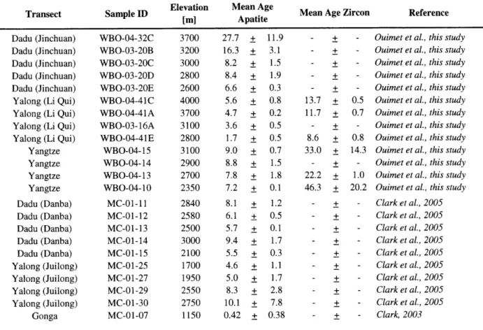
The eastern margin of the Tibetan Plateau is one of the world's broadest and most dramatic transient landscapes, characterized by a regionally persistent, elevated, low-relief relict landscape that has been deeply dissected by major rivers and their tributaries (Clark et al., 2006; Fig. 1). Thermochronological data show that rates of rock cooling on the eastern margin of the plateau increased dramatically between 9 and 13 Ma, suggesting that uplift and major river
incision began at that time (Kirby et al., 2002; Clark et al., 2005). Major rivers start at high elevations over 4000 m where they are slightly incised into the relict landscape, and transition into rapidly incising, high-relief, dissected gorges with steep hillslopes (Fig. 2). Estimates of long-term (106 - 107 yr) bedrock river incision in these gorges are on the order of 0.25 - 0.5
mm/yr (Clark et al., 2005). Longitudinal river profiles exhibit transient morphologies, with large knickpoints, and convex to linear, rather than concave, profile forms. Hillslopes, following incision, display zones of adjustment with steepest values in the lowermost reaches of individual basins. These observations highlight the transient response of rivers to rapid incision on trunk streams as waves of landscape adjustment propagate upstream and up hillslopes.
The Dadu River (Dadu He) and Yalong River (Yalong Jiang) are major tributaries of the Yangtze River (Jinsha Jiang), both over 1000 km in length (Fig. 2). Bedrock geology in these catchments consists mainly of the Songpan-Ganze flysch terrane, which is intruded by a series of Jurassic age granitic plutons (Roger et al., 2004), and deformed Paleozoic rocks and crystalline Precambrian basement that outcrop in the southern portions of each catchment (Burchfiel et al.,
1995). The most prominent active fault within these catchments is the Xianshuihe Fault, a large-scale, strike-slip fault slipping at -10 mm/yr (-60 km total offset) that has experienced four earthquakes greater than magnitude 7 in the last century (Allen et al., 1991). The Dadu and Yalong rivers have each experienced catastrophic landslide damming events within the last 250 years that were triggered by large, >6.0 M earthquakes (Tianchi, 1990; Dai et al., 2005).
Accounts from the example on the Dadu River indicate as many as 100,000 deaths were caused by the downstream flooding associated with initial dam failure, making it one of the most
Chapter 2 - Landslides
disastrous events ever resulting from a landslide dam breach (Dai et al., 2005). Recent
catastrophic events such as these have also been documented in the Min River gorge to the east of the Dadu and in the main Yangtze River gorge to the west of the Yalong, indicating that landslide damming is a widespread and ongoing phenomenon in all river gorges on the eastern margin (Tianchi, 1990; Hejun et al., 2000).
River Morphology and Large Landslides
Fieldwork conducted during 2003-2006 along the trunk streams and major tributaries of the Dadu and Yalong indicates that valleys contain a combination of fluvial and landslide deposits, tributary alluvial fans, lake sediments, debris-flow, deposits and bedrock (see Data Repository for photos). Numerous low-gradient topographic benches 50-1000 m above the modem river level previously interpreted as river terraces, were determined to be fluvially beveled landslide deposits, the tops of ancient landslide dams, or high levels of alluvial gravel
and lake sediment associated with landslide deposits. Channel and valley widths vary greatly as channels alternate between straight, narrow-walled, steep, incising bedrock reaches and
meandering, wide, gentle, depositional alluvial reaches. Bedrock reaches generally have steep bedrock hillslopes adjacent to channels. Hillslopes are also steep within alluvial reaches, but the large volume of sediment filling the valley in these reaches and the meandering nature of the
channel disconnects channels from adjacent hillslopes and suggests that the bedrock valley floor is far below the present channel bottom.
Other than the occasional steep bedrock reaches, most steep reaches are boulder rapids, 10-1000 m long, that are found only in association with landslides, rockfalls, and debris flow deposits. Many of these rapids occur at the location of well-defined, large, deep-seated landslide events (>5 x 10⁵ m3) that are easily identified based on their morphology and textural
characteristics (Fig. 3). These large landslides appear, in many cases, to have led to extensive and prolonged river damming, as deposits from large landslides frequently coincide with
upstream sediment interpreted to be related to impoundment and aggradation behind present and paleo-landslide dams (e.g. lake sediments and alluvial fill). Landslide deposits vary from large fragments of intact bedrock, variably brecciated and fractured, to a complete mix of
unconsolidated, poorly sorted material ranging in size from pulverized rock, dust and sand to 10-to 30-m-diameter boulders.
Chapter 2 - Landslides
Depending on how recently the damming event occurred and how large the event was, river channels are incised into landslide deposits and upstream fill to varying degrees (Fig. 3).
Some landslide dams still have lakes upstream, while others are completely filled in with alluvium upstream, with large alluvial fans graded to the height of the ancient landslide dam outlet level, some with picturesque villages built upon them indicating substantial antiquity. In other cases, preserved relics (lake sediments, alluvial fill and ancestral tributary fans) of much older landslide dams high up on valley walls suggest extremely large damming events have occurred, or that damming events occurred when the trunk level was higher than it is today.
Throughout river gorges on the eastern margin of the Tibetan Plateau, we find a range of landslide dam sizes with stable heights between tens to hundreds of meters, affecting stretches of river ranging from hundreds of meters to over 20 km in length. The age of most of these
landslide events is unknown; known ages range from modem examples (as recently as 1933) to ones reaching as far back as >40,000 yrs (14C age). We have dated three landslides with
cosmogenic radionuclide (10Be) exposure ages to -8,800, -6,500, and -57,000 years old. We have also used optically stimulated luminescence (OSL) to date lake sediments associated with one ancient dam to -5,000 years old. In some cases, landslides linger within river gorges, influencing incision for 105-106 yrs (as indicated by at least one location where recurrent landslides and local rock properties appear to have effectively inhibited a major tributary from keeping pace with trunk-stream incision in the past -9-13 Ma). In some regions on the Dadu River, the integrated effect of many large landslides and dams appears to have effectively dammed stretches of river up to 100 km in length, forcing them to become alluviated.
Case Study 1: Dadu Gorge and Tributaries -Danba Region
The Danba region in the Dadu catchment hosts several excellent examples of the interaction between landslide dams, river profiles, and channel morphology (Fig. 4). The bedrock geology around Danba consists of a structural antiform that exposes deeper, deformed levels of the Paleozoic sequence beneath the Triassic/Jurassic Songpan-Ganze flysch, notably a
Silurian mica-rich schist. This schist is prone to large landslides, and, consequently, hillslopes around Danba commonly have hummocky landslide morphology. At Danba, the Dadu trunk
stream (named Dajin Chuan here) joins three large tributaries, the Ge Sud Za He, Xiaojin Chuan, and Dong Gu He, in a star-shaped pattern. Upstream from Danba, there are significant
Chapter 2 - Landslides
related knickpoints on the Dadu mainstem and on all three of these tributaries. The abrupt knickpoints in all these river profiles are related to landslides, with the same morphology as knickpoints created by rivers that cross a sharp lithologic contrast (i.e., weak rock type to
strong), or by transient river response to upstream migration of incision in models of detachment-limited bedrock river incision (Whipple and Tucker, 2002).
The Ge Sud Za He tributary, in particular, is dominated by landslide dams, boulder rapids, and impounded alluvial fills for 40 km upstream of its confluence with the Dadu
mainstem (Fig. 4). The most dramatic of these landslide dams occurs 15 km upstream from the confluence with the Dadu, with -~ 150 m of drop in the rapids caused by the landslide deposits. Field surveys show nicely the characteristic drop in channel width and increase in channel slope across the landslide mass where the channel is armored by large boulders (Fig. 5). This
particular example shows a period of prolonged upstream filling, as numerous large alluvial fans upstream are graded into the new base-level set by the landslide dam. The age of the landslide is 8,812 ± 590 years, based on a cosmogenic radionuclide (10Be) exposure age for a large, -10 m
diameter boulder on top of the landslide deposit.
Case Study 2: Li Qui River
The Li Qui River is a 190 km long tributary of the Yalong River, with 1800 m of fluvial relief, and a total drainage area of 5,880 km2. The Li Qui drains off a low-relief landscape perched -2-2.5 km above local base-level and transitions into a rapidly incising, dissected landscape in its lower reaches, where a pronounced knickpoint on the longitudinal profile accounts for most (-1 km) of the fluvial relief (Fig. 6). Landslides have fundamentally altered the morphologic expression of the transient response of the Li Qui to mainstem incision on the Yalong. There is extensive evidence for the influence of landslides on valley and river profile geometry (Fig. 6d). Well-preserved lake and alluvial fill gravels record a period of prolonged river damming, but the river has subsequently incised into a portion of these sediments. The highest fill level increases in height moving downstream, and widespread landslide deposits indicate the likely site of an ancestral landslide dam. All fill levels end at the site of the inferred landslide dam -40 km upstream of the Yalong confluence. Farther downstream, within the last 20 km before its confluence with the Yalong, the Li Qui River is extremely steep due to a combination of rapid base-level fall and large landslide debris within the present channel. This
Chapter 2 - Landslides
stretch of river is one of the steepest reaches of river in the Dadu and Yalong catchments, dropping at -3.3% for 40 km, and it coincides with where the Li Qui River runs south of a granite intrusion. The large boulders seen in the channel along this stretch are granite, presumably delivered to the channel from rockfalls and landslides.
Barring the presence of an as-yet-unknown localized tectonic uplift, we surmise that the greater bed roughness created by these large, immobile unfractured boulders, together with their intrinsic resistance to abrasion, have significantly impeded the incision of the Li Qui River, leading to the formation of this - 1-km-high knickpoint. That channels are steeper crossing stronger, more erosion-resistant lithologies is to be expected, because rivers maintain steeper slopes and more erosive power to erode their bed in these areas to keep pace with areas upstream and downstream. However, landslide effects suggest that channels are steeper at stronger, more erosion-resistant lithologies because it is harder to erode bedrock in those areas, and the massive nature of bedrock lithology in these areas yields large, erosion-resistant boulders during mass wasting events. The integrated effect of large landslides on the Li Qui is to prohibit bedrock incision and slow the upstream migration of incision on the Yalong trunk stream. This promotes the survival of large patches of relict landscape (see Figures 1 and 6a). Landslide damming and subsequent re-incision give the Li Qui longitudinal profile its smooth, convex shape, which otherwise might have been interpreted as representing a diffuse, transport-limited transient response to a base-level fall (e.g., Begin et al., 1980). Transient river profile form, therefore, is not simply diagnostic of alternate forms of bedrock river incision models as suggested by Whipple and Tucker (2002), but rather can reflect a complex combination of factors.
NUMERICAL MODELING
The prevalence of landslide dams impacting river channel morphology on the eastern margin of the Tibetan Plateau, and elsewhere (Korup et al., 2006), motivates us to formulate a quantitative framework for how landslides influence river incision, and, hence, landscapes in general. In this section, we develop a numerical model to simulate the occurrence and erosion of stable landslide dams along a length of river based on simple rules for the timing and magnitude of landslide events and generalized models for the erosion of individual dams once they stabilize. We also derive basic analytical expressions for the long-term average number of landslide dams
Chapter 2 - Landslides
along a river and relate them to the burial of bedrock valley floors and reduced river-incision efficiency.
Overview
The schematic in Figure 7a represents a snapshot in the evolution of rivers where
landslide dams occur and erode through time, such as on the eastern margin. At any given time, there is a distribution of landslide dams along a length of river that may comprise all stages of
erosional decay from fresh, uneroded dams to small remnants of previous dams. Each landslide dam is associated with a wedge of landslide deposits and aggraded material that buries bedrock valley floors and inhibits incision. The percentage of channel buried, which we call the landslide burial factor (Bf), is therefore a function of the number of landslide dams that exist and their
heights above the bedrock floor (dam height sets the upstream extent of aggraded alluvium; Fig. 7b). We can estimate Bf within river gorges on the eastern margin through a combination of field mapping and analysis of river profiles (Fig. 4; Table 1). These modern estimates of Bf are appropriate for, at most, the last 8,000 to 10,000 yrs, but we take them as being indicative of the long-term averages expected for these rivers. As we will show later in this section, Bfis roughly equivalent to the percentage of fluvial relief on rapids and falls associated with landslide
knickpoints.
Our modeling is aimed at understanding what controls the average number and height of landslide dams along a river because these factors will directly, and significantly, affect the efficiency of river incision. These long-term averages imply an average sum of landslide dam heights and, therefore, a long-term average Bf. Bfis a direct measure of the influence of
landslides on river-incision efficiency, since the fraction of the channel bottom not buried under deep fills, and thus generally available for incision (Ba) is 1-Bf (i.e., 0 to 1). Low values of Ba imply a stronger, more intense landslide effect with lower river incision efficiency; values closer to one imply a weak, negligible landslide effect with river-incision efficiency close to what it should be in the absence of landslide dams. Ba can be considered a rough scaling factor that should modulate the coefficient of river incision (K) in many models. Analysis of the controls on Ba is thus a key to gauging the long-term, integrated influence of recurrent stable landslide dams. Our approach is to investigate the two fundamental timescales that together govern the
Chapter 2 - Landslides long-term average number and heights of stable landslide dams, and, therefore, Bfand Ba. These are the landslide recurrence interval and landslide dam survival time.
In this treatment we are only considering stable landslide dams that erode gradually after they form; this includes dams that stabilize initially or after some degree of catastrophic failure and dam-outburst flood erosion. We acknowledge that many landslides will occur that do not form stable dams, but we do not consider how these non-stable landslides might affect sediment dynamics and the modes by which rivers erode existing landslide dams. These we consider part of the background controls on river incision onto which the effect of river-damming landslides is superimposed. Incorporating the role of outburst floods associated with full or partial failure of landslide dams is an interesting problem that is beyond the scope of the current analysis. We acknowledge that this phenomenon is a mechanism by which large landslide blockages can act to enhance the efficiency of river incision and may act to counteract the negative feedback
addressed here.
Landslide Dam Occurrence
The first fundamental timescale that influences the average number of landslide dams along a river is the recurrence interval of large landslides that occur randomly along a river and may lead to stable dams (Ts). Our model simulates river systems experiencing frequent large landslides, where some subset of landslides that occur lead to stable landslide dams distributed randomly along a length of river. We examine three model scenarios that draw from probability distributions of landslide recurrence intervals, Ts, and.initial stable dam heights, zo. In the first scenario, we explore the very simple case in which one stable landslide of fixed height zo occurs at constant recurrence interval Ts. In the second scenario, we consider the case in which zo and
Ts vary independently and are normally distributed around fixed mean values. In the third
scenario, we investigate the case in which landslide area and resulting stable dam height are derived from a power-law frequency-magnitude distribution of landslides.
In this third model scenario, zo and Ts are related such that larger landslide dams have much lower recurrence intervals as a consequence of the properties of a power-law distribution.
A power-law distribution for medium to large landslides (landslide area >104 m2) has been
recognized by many authors (e.g., Hovius et al., 1997; Stark and Hovius, 2001; Malamud et al., 2004a). This distribution holds for landslides occurring in space and time throughout a given
Chapter 2 - Landslides
landscape, and has been documented in diverse landscapes around the world (Hovius et al., 2000; Malamud et al., 2004b). We assume that a subset of all landslides occurring within a landscape will reach the main channel, and furthermore, a subset of these landslides will lead to stable landslide dams. Since this small subset should have the same distribution as the original, we argue that the distribution of stable landslide dams occurring along the length of a river through time is reasonably modeled using a power-law distribution:
NLsd(A) = cA" (1)
where NI~d(A) is the number of landslide dams that originate from a landslide of area A [m2], c is the rate of landsliding per year [yr-1], and flis the dimensionless scaling exponent (e.g. Hovius et al., 1997). Our third model scenario generates random landslide events that obey the power-law frequency-magnitude distribution of equation 1. As landslides happen, we also use a threshold landslide area (-0.1 km2, or 105 m2) to set which landslides lead to landslide dams and a
conversion factor (20-150 m/km2) to determine initial landslide dam height from landslide area. Values of this conversion factor are constrained by field examples and published studies of landslide sizes that have led to stable landslide dams (Hewitt, 1998). The resulting distribution of initial landslide dam heights, zo, scales with the power-law distribution of landslide events that occurred, governed by the scaling parameters f and c, along with the threshold area size and landslide area to landslide dam height conversion factor. We use values of f ranging from 0.7 to 1.4, where higher values of f8 lead to a steeper frequency-magnitude distribution and lower probabilities of occurrence for the largest landslide dams. Coefficient c represents not only the frequency of landslide events, but also the fraction of these events that ultimately form stable landslide dams, such that higher values of c lead to higher probabilities of occurrence for all landslide dams.
Landslide Dam Erosion
The second fundamental timescale that influences the average number and height of landslide dams along a river is the time it takes to incise through landslide deposits, fully breach individual dams and re-incise through the associated sediment wedge (Te). Our model utilizes simple rules of erosion for individual dams to calculate Te. Stable landslide dams can act either as masses of tightly packed, large boulders that erode as a whole in essentially the same manner as intact bedrock, or as more loosely packed, immobile boulders that armor the bed, add
Chapter 2 - Landslides roughness, dissipate stream energy, and inhibit erosion of the dam during even the highest flows. In addition, landslide deposits may deflect river channels within their valleys and re-incision may incorporate bedrock spurs of the former valley, enhancing the duration of the blockage. We do not attempt to model explicitly these complex processes. Rather we seek only to highlight the fundamental role of the timescale of dam removal.
In our model, stable landslide dams decay either in a linear fashion or exponentially (Fig. 8). Linear erosion proceeds at a specified, constant erosion rate (m). Exponential erosion is based on the premise that incision rate scales with dam height (i.e., downstream knickpoint slope) and is parameterized by a decay timescale (4). We track landslide height through time,
z(t), based on an initial height, zo, where dz/dt is the rate of change of landslide height.
Exponential erosion incorporates the following equations:
dz/dt = -Z/I (2) z(t) = zoe / r (3)
Te = 5r (4)
Zavg = zo5 (5)
Linear erosion, by comparison, incorporates:
dz/dt = - m (6)
z(t) = zo - mt (7) Te = zo/m (8) Zavg = zo/2 (9)
In the exponential case, Te is 5z, the time it takes to reduce zo to ~ 1% of its original value (e-5 -0.01). We adjust values of rand m to produce Te values between tens to ten thousands of years (i.e., faster or slower landslide dam erosion) (Fig. 8a). For each model of erosion, we also
calculate a mean landslide dam height over Te, denoted zavg. For cases with identical timescales of erosion (Te), mean dam height over its life time (zavg) is greatly reduced (by -40%) in the exponential erosion case owing to the very rapid initial incision (Fig. 8b).
Model Results
Model runs simulate the evolution of landslide dams as they occur and erode along a length of river. The sum of landslide dam heights reflects the total number and size of landslide dams through time (Fig. 9). As erosion parameters are held constant, variability originates from