HAL Id: hal-02495457
https://hal.archives-ouvertes.fr/hal-02495457
Submitted on 2 Mar 2020
HAL is a multi-disciplinary open access
archive for the deposit and dissemination of
sci-entific research documents, whether they are
pub-lished or not. The documents may come from
teaching and research institutions in France or
abroad, or from public or private research centers.
L’archive ouverte pluridisciplinaire HAL, est
destinée au dépôt et à la diffusion de documents
scientifiques de niveau recherche, publiés ou non,
émanant des établissements d’enseignement et de
recherche français ou étrangers, des laboratoires
publics ou privés.
Firefighter indoor localization (POUCET)
Viken Kojakian, Denis Genon-Catalot, Nicolas Fourty, Baptiste Pestourie,
Réjane Dalce, Adrien van den Bossche, Thierry Val, Quentin Vey, François
Spies, Christelle Bloch, et al.
To cite this version:
Viken Kojakian, Denis Genon-Catalot, Nicolas Fourty, Baptiste Pestourie, Réjane Dalce, et al..
Fire-fighter indoor localization (POUCET). IEEE Radio and Antenna Days of the Indian Ocean (RADIO
2019), Sep 2019, La Réunion, France. pp.0. �hal-02495457�
Official URL
DOI :
https://doi.org/10.23919/RADIO46463.2019.8968931
Any correspondence concerning this service should be sent
to the repository administrator:
[email protected]
This is an author’s version published in:
http://oatao.univ-toulouse.fr/25037
Open Archive Toulouse Archive Ouverte
OATAO is an open access repository that collects the work of Toulouse
researchers and makes it freely available over the web where possible
To cite this version: Kojakian, Viken and Genon-Catalot, Denis
and Fourty, Nicolas and Pestourie, Baptiste and Dalce, Rejane and
Van Den Bossche, Adrien and Val, Thierry and Vey, Quentin and
Spies, François and Bloch, Christelle and Chapuis, Vincent and Da
Silva, Albert and Stenta, Michel Firefighter indoor localization
(POUCET). (2020) In: IEEE Radio and Antenna Days of the
Indian Ocean (RADIO 2019), 23 September 2019 - 26 September
2019 (La Réunion, France).
Firefighter indoor localization (POUCET)
Viken Kojakian, Denis Genon-Catalot,
Nicolas Fourty, Baptiste Pestourie
LCIS Laboratory University Grenoble Alpes
Valence France
viken.kojakian, denis.genon-catalot, nicolas.fourty,
François Spies, Christelle Bloch, Vincent Chapuis Femto-ST laboratory
Besançon Montbéliard, France
Réjane Dalce, Adrien van den Bossche,
Thierry Val, Quentin Vey
CNRS-IRIT Laboratory Toulouse, France [email protected], vandenbo@univ-tlse2, therry.val, [email protected]
Albert Da Silva
Geoconcept Arcueil, France [email protected]Michel Stenta,
Digichrome [email protected]Abstract: Indoor positioning is a growing demand for many uses:
orientation in subways, shopping promotions, Internet of Things (IoT). These radio systems need dedicated wireless infrastructure deployment in order to provide users orientation information. In this paper, we present an emergency hybrid localization system which could help policemen or firefighters find their ways in a building on fire for rescue operations.
I. CONTEXT
For the Agence Nationale de la Recherche (ANR)- Diréction Générale de l’Armement (DGA)-ASTRID project, several selected companies and laboratories compete each year during one week to test various solutions allowing fast deployment for indoor positioning: inertial systems, camera detection systems, and wireless measurement of distance. Three French laboratories (Femto-ST-Bsançon, IRIT-UT2J Toulouse, and LCIS-Valence) and two companies joined their efforts to design a new radio-based solution for an Indoor Positioning System (IPS). They combined IEEE 802.15.4 Impulse Radio Ultra-Wide Band (IR-UWB 6 to 6.5 GHz) with LoRa (868 MHz and 2.4 GHz) technology to cover various building topologies. For firefighter application, we propose to integrate radio modules in autonomous light sources elements deposited on the ground firefighters to indicate the path during the interventions. To obtain accurate information position, we propose to add localized beacon radio modules outside the building. Thus, firefighters will obtain orientation information from different beacons to find their way to the building exit in the absence of visibility . With a dedicated user interface supported by an industrial partner, we can collect wireless data to provide information to the operation task force leader which shows the position on a map for each firefighter in operation.
II. INTRODUCTION
In a well-known environment, a long set up time and adaption may be required for the installation and proper
deployment of the indoor location service which use radio signals. The problem is quite different in the case of an emergency situation. Indeed, the initialization time must be very short and the operating time is limited. However, it is still possible to install an emergency infrastructure that runs on batteries for a few hours. In this paper, we will study three technologies to calculate the distance between a worn node simulating firefighters and quickly deployed anchors. These nodes will combine time of flight and receive signal strength data to compute distances accurately.
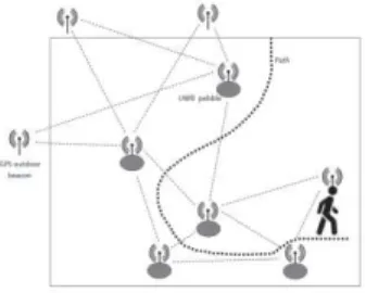
Fig. 1 Architecture for Indoor localization with radio signals
III. MEASUREMENT ESTIMATION DISTANCE
Measuring the radio signal strength in a homogeneous environment makes it possible to estimate a distance between a transmitter and a receiver, provided that the power parameters and antenna characteristics are well known. In a heterogeneous environment such as a building, the challenge is to be able to evaluate a propagated signal absorption factor so that the transformation function between received signal strength and distance can be sufficiently accurate. Despite the calculation of accurate environmental absorption factor, in some cases, the distance-calculation function may be inaccurate due to multi-path effect viewable in a heterogeneous environment. To take this into account, it is
necessary to be able to measure a confidence value associated with the result to estimate the accuracy. By placing enough beacons, it is possible to introduce a sort of redundancy in the information produced in order to select the most consistent results. This calculation, which we call selective multilateration, allows us to obtain fairly accurate results even when a minority of measurements is subject to an unpredictable multi-path effect.
A. Localization by LoRa signal strength mesurements
We use 868MHz-LoRa signal to measure signal strength and to calculate distances. This signal strength is quite stable according to the distance because it is on a narrow bandwidth and the signal is well adapted to go through walls with a high value of spreading factor. This solution is currently well-adapted for long distance throw with more than one wall. B. Localization by LoRa time of flight (2.4 GHz)
The new possibility 2.4 GHz LoRa modulation extended our possibilities, as we wanted to know what behavior we could expect with geolocation in a Non-Line of Sight (NLOS) environment. To explore this possibility, we worked on a ranging functionality using LoRa within the Industrial, Scientific and Medical (ISM) band at 2.4 GHz. The method uses measurement of a round trip time of flight between two LoRa devices: one device is set as the Master device and another is set as the Slave device. The Master initializes the ranging request to the Slave while starting an internal timer. The Slave receives the request and replies to the Master. The Master will then deduce the round-trip time of flight. This request is done for a number of round-trip time (minimum 10 up to 255), for a better-averaged result. Each request is done on different frequencies from 2402 MHz to 2480 MHz with a 2 MHz step to avoid fading on certain frequencies.
For 1000 ranging averaged results, it takes 82.46 seconds. On the field, we can access to 12 nodes ranging averaged results per seconds.
C. Localization by Time of Flight using Ultra Wide Band Among the many radio signal characteristics that can be used for distance evaluation, the time it takes the signal to travel from the emitting antenna to the receiving antenna, also known as Time of Flight (ToF), usually displays the best performance in terms of accuracy. Using the speed of light, this ToF value can be converted into an estimated distance which will be fed to localization engine and result in a device’s position. So far, the most promising technology for this application is Ultra-Wide Band (UWB): its wide bandwidth allows for very fine distance resolution.
This paper introduces a UWB/ToF-based localization system: after evaluation its feasibility, we review the implementation process and conduct a performance evaluation campaign. The envisioned system consists of a set of fixed radio devices forming a partial mesh network and a few mobile nodes. The fixed part of the network is initiated through a small subset of devices with known positions
obtained, for instance, through Differential Global Positioning System (GPS). As the entity carrying the mobile device explores the environment, it randomly places future fixed nodes that will compute their positions in a collaborative and incremental fashion. Among the measured characteristics of the signal, we are particularly interested in the ability for the nodes to distinguish between Line Of Sight (LOS) and NLOS links. This information will enable them to select the best reference nodes for distance evaluation as well as contribute to the evaluation of a confidence metric along the mobile’s path. This LOS information can also be used to characterize the environment and detect relative movement of the devices. This idea forms the underlying principle of the UWB section of this study. As the name implies, our radio devices will play the role of the famed bread crumbs that help the children find their way in an unknown environment.
IV. CONCLUSION
Each of the technologies presented work separately properly in a specific environment. All the technologies presented have various accuracy and LOS/ NLOS resilience. While Lora (868 MHz) has better wall penetration, UWB has better accuracy, for instance. The goal of this project is to define an adequate data fusion algorithm to have the best accuracy and resilience. Moreover, each technology already has a specific ranging confidence level based on physical information from the physical layer. One of our next objectives is to unify these confidence level in order to define which ranging is the best suited for each situation. For the firefighter application we will test system with all technologies in Blois Fire and Rescue Center in September 2019.
ACKNOWLEDGEMENT
This research contribution is supported by French ANR-DGA-ASTRID for 30 months project. Our team is composed of 3 French labs and 2 companies were involved in this proof of concept. This project is built as a contest with 6 other French teams. Every year during one week the 6 teams compare their results on real field experimentation to propose at least to build one operational system.
REFERENCES
[1] CYP2013 M. Cypriani, G. Delisle, N. Hakem, WiFi -based Positioning in underground mine tunnels, Indoor Positioning and Indoor Naviation 2013
[2] DALC2013 R. Dalce, A. Van den Bossche, T. Val. Indoor Self-Localization in a WSN, based on Time Of Flight:Propositions and Demonstrator, IEEE International Conference on Indoor Positioning and Indoor Navigation,2013.
[3] DALC 2015 R. Dalce, A. Van den Bossche, T. Val. Reducing localisation overhead: a ranging protocol and anenhanced algorithm for UWB-based WSNs, IEEE Vehicular Technology Conference,
[4] 2015 DALC2016 R. Dalce, A. van den Bossche, T. Val, “A study of the ranging error for Parallel Double Sided-Two WayRanging protocol”, IEEE Vehicular Technology Conference, 2016
[5] 2016 LAMI2016 Y. Lami, G. Nocera, D. Genon-Catalot, N. Fourty, Landslide prevention using a buried sensor network,Radio and Antenna Days of the Indian Ocean
[6] 2016LEB2016 J. M. Lebreton, S. Kandukuri, N. Murad, D. Genon-Catalot, Interference evaluation of WiFi devices overwake-up radio in wireless sensor networks, Radio and Antenna Days of the Indian Ocean