HAL Id: hal-01268793
https://hal.archives-ouvertes.fr/hal-01268793
Submitted on 27 May 2020
HAL is a multi-disciplinary open access
archive for the deposit and dissemination of
sci-entific research documents, whether they are
pub-lished or not. The documents may come from
teaching and research institutions in France or
abroad, or from public or private research centers.
L’archive ouverte pluridisciplinaire HAL, est
destinée au dépôt et à la diffusion de documents
scientifiques de niveau recherche, publiés ou non,
émanant des établissements d’enseignement et de
recherche français ou étrangers, des laboratoires
publics ou privés.
China – challenges for sustainable development
R. C. Silde, Alexia Stokes, Muriel Ghesthem
To cite this version:
R. C. Silde, Alexia Stokes, Muriel Ghesthem. Epic landslide erosion from mountain roads in
Yun-nan, China – challenges for sustainable development. Natural Hazards and Earth System Sciences,
European Geosciences Union, 2014, 14, pp.3093-3104. �10.5194/nhessd-14-1-2014�. �hal-01268793�
www.nat-hazards-earth-syst-sci.net/14/3093/2014/ doi:10.5194/nhess-14-3093-2014
© Author(s) 2014. CC Attribution 3.0 License.
Epic landslide erosion from mountain roads in Yunnan, China
– challenges for sustainable development
R. C. Sidle1,*, M. Ghestem2, and A. Stokes3
1US Environmental Protection Agency, Ecosystems Research Division, National Exposure Research Laboratory, ORD,
960 College Station Road, Athens, GA 30605, USA
2ONCFS, CNERA PAD, 5 allée de Bethléem, 38610 Gières, France
3French National Institute for Agricultural Research (INRA), AMAP, Bld de la Lironde, 34398 Montpellier CEDEX 5, France *current at address: University of the Sunshine Coast, Sustainability Research Centre, Locked Bag 4,
Maroochydore, QLD 4558, Australia
Correspondence to: R. C. Sidle (rsidle@usc.edu.au)
Received: 10 April 2014 – Published in Nat. Hazards Earth Syst. Sci. Discuss.: 3 June 2014 Revised: – – Accepted: 13 October 2014 – Published: 27 November 2014
Abstract. Expanding systems of mountain roads in
devel-oping countries have significantly increased the risk of land-slides and sedimentation, and have created vulnerabilities for residents and aquatic resources. We measured landslide ero-sion along seven road segments in steep terrain in the upper Salween River basin, Yunnan, China and estimated sediment delivery to channels. Landslide erosion rates along the roads ranged from 2780 to 48 235 Mg ha−1yr−1, the upper end of
this range being the highest rate ever reported along moun-tain roads. The two roads with the highest landslide erosion (FG1 = 12 966 Mg ha−1yr−1; DXD = 48 235 Mg ha−1yr−1) had some of the highest sediment delivery rates to chan-nels (about 80 and 86 %, respectively). Overall, 3 times more landslides occurred along cut slopes compared to fill slopes, but fill slope failures had a combined mass > 1.3 times that of cut slope failures. Many small landslides occurred along road cuts, but these were often trapped on the road surface. Given the magnitude of the landslide problem and the lack of atten-tion to this issue, a more sustainable approach for mountain road development is outlined based on an analysis of land-slide susceptibility and how thresholds for landland-slide trigger mechanisms would be modified by road location and differ-ent construction techniques.
1 Introduction
Although there is ample evidence of the effects of moun-tain road development on landslide initiation, only recently has this issue been raised within the context of sustainable development and the potential collapse of certain ecosys-tem functions (Sidle and Ziegler, 2012; Sidle et al., 2013). In particular, the extent of environmental damage caused by landslides along mountain roads in developing nations is poorly understood. While numerous international donors, non-governmental organizations (NGOs), and environmental advocates have attributed increased sedimentation in rivers and streams in these regions to shifting cultivation and defor-estation (e.g., UNESCO, 1974; Eckholm, 1979; Volk et al., 1996; Marshall, 1999), more comprehensive investigations and analyses recognize that these land use practices exert much less influence on downstream sediment and aquatic re-sources than poorly constructed mountain roads (Sidle et al., 2006, 2007, 2011; Wasson et al., 2008; Ziegler et al., 2009). Of course, road and trail systems are associated with shifting cultivation and deforestation, but more recent, rapid expan-sion of road networks in mountainous terrain of developing nations have been linked to transitions from shifting cultiva-tion to more intense agriculture, increased tourism, economic development, national defense, emergency evacuation routes, and hydropower development (Krongkaew, 2004; Nyaupane et al., 2006; Ziegler et al., 2012; Urban et al., 2013). Rural road development in Southeast Asia has been aggressively
supported by organizations such as the Asian Development Bank, the Food and Agricultural Organization of the United Nations, and the World Bank, largely based on perceived so-cioeconomic benefits (van de Walle, 2002; Balisacan, 2005; Hettige, 2006). In most cases, long-term sustainability as-sessments that weigh the relative benefits and impacts of ru-ral mountain roads, including socioeconomic tradeoffs, have not been conducted (Sidle et al., 2013).
Any road constructed in steep terrain will decrease the sta-bility of the hillslope (Sidle and Ochiai, 2006). Roads cut into steep slopes promote landslides by removing upslope support and oversteepening the cut slope (Megahan et al., 1978; Rice, 1999; Sidle et al., 2006). Fill slopes, particularly when ex-cavated fill material is poorly compacted, are susceptible to failure due to overloading and oversteepening of the slope, as well as when road drainage concentrates on these sites (Burroughs et al., 1976; Douglas et al., 1999; Sidle et al., 2011). As such, mid-slope mountain roads tend to create the most severe landslide problems because they experience both cut-and-fill failures including intercepting substantial quan-tities of subsurface water which often triggers landslides in fill slopes (Wemple et al., 2001; Sidle and Ochiai, 2006). If the terrain below these mid-slope roads is steep, much of the landslide material can directly reach streams or rivers, con-tributing significantly to sedimentation (Mills, 1997; Sidle et al., 2011). Because a significant portion of new rural road construction in northern Yunnan, China, as well as through-out developing regions of Sthrough-outheast and East Asia, is occur-ring in steeply dissected mountainous regions, the associated landslides and sedimentation are problematic (Nyaupane et al., 2006; Wasson et al., 2008; Sidle and Ziegler, 2012). How-ever, such land management effects have not been well docu-mented, particularly with regard to sediment sources and de-livery. A recent empirical assessment of the combined effects of structural control measures, vegetation restoration, and cli-mate change on reduction of suspended sediment in the Kejie catchment within Yunnan noted that the former two practices were most effective in reducing suspended sediment (Ma et al., 2014); however, road inputs were not assessed in this study and the model used in the analysis (SWAT) has been clearly shown to ignore mass wasting contributions and pro-duces erroneous sedimentation estimates in unstable terrain (Sidle, 2006).
Structural measures to prevent landslides along roads have been used effectively in vulnerable sites (e.g., Holtz and Schuster, 1996) but are prohibitively expensive in remote re-gions of most developing countries (Sidle and Ochiai, 2006). Check dams in streams and rivers can effectively remove sed-iment (Ma et al., 2014), but are expensive and do not ad-dress problems at the source or in upstream reaches, and are not sustainable control measures. Furthermore, little atten-tion has been paid to road locaatten-tion and construcatten-tion tech-niques in mountainous Southeast Asia (Sidle et al., 2004, 2006, 2011; Ziegler et al., 2004, 2012). As such, landslide issues need to be more carefully considered by many of the
agencies that initiate and control the construction of such corridors in developing nations, as well as environmental groups and international organizations, which are focusing more on widespread land cover changes and hydropower de-velopment (Sidle and Ochiai, 2006; Tullos et al., 2013).
One of the first instances of heightened environmental awareness of road-related landslides was associated with sed-imentation of streams and resultant impacts on fish habitat in the Pacific Northwest, USA during the 1970s and 1980s. Rates of landslide erosion from secondary forest roads in un-stable terrain of Oregon and Washington ranged from 25 to 155 Mg ha−1yr−1 (Sidle et al., 1985). These impacts were believed to be significant enough to severely curtail logging of forests on government lands in this region. Prior to this time, the major stability concerns with mountain roads fo-cused on road closure, repair costs, and the maintenance needed to retain access (e.g., Bansal and Mathur, 1976; Chas-sie and Goughnour, 1976; Fleming and Taylor, 1980).
Little emphasis has been placed on the impacts of land-slides on environmental health and human welfare in devel-oping countries of Asia where secondary mountain road sys-tems are expanding at a rapid pace (Haigh, 1984; Sakakibara et al., 2004; Castella et al., 2005). Within China, the total road length of rural transportation networks increased by 5.5-fold during the 30-year period from 1978 through the end of 2007 (China Road Construction Report, 2008). A recent study (Sidle et al., 2011) that reported extremely high lev-els of landslide erosion (1410–33,450 Mg ha−1yr−1)along a recently constructed road in the Mekong River basin of Yun-nan, China, as well as observations of similar and prolific landslide problems in the upper Salween and Jinsha River basins of Yunnan Province, encouraged us to examine this issue in greater detail and across a wider range of mountain roads. Herein, we present comprehensive landslide measure-ments at five general locations (with a total of seven road segments) within the Salween River basin of northern Yun-nan, China, as well as estimates of the delivery of landslide sediment to streams and rivers. This study aims to provide a quantitative basis for government and local planning agen-cies, international donors, and conservation groups to fo-cus their priorities and efforts related to mountain road ex-pansion, location, and construction. Additionally, we show how this information can be used in sustainability assess-ments for mountain ecosystems subject to these development pressures.
2 Site considerations
The steep Hengduan Mountains of western Yunnan Province are currently experiencing rapid development pressures due to the opening of access to remote villages, hydropower development, agriculture, tourism, forest exploitation, and other related aspects of economic development. This area includes the north–south trending, deeply dissected gorges
of the “three great rivers” (i.e., Salween, Mekong, and Jin-sha rivers) within “The Three Parallel Rivers of Yunnan Pro-tected Areas”, inscribed by UNESCO on the World Heritage List in 2003 based on their unique geological history, geo-morphic features, ecological processes, and rich biodiversity (UNESCO, 2003). The Salween River (known as the Nu-jiang in China) originates in the Tibetan Plateau and winds down steep gorges in northern Yunnan, along the border of southern Myanmar and northwestern Thailand, and eventu-ally discharges into the Andaman Sea off the coast of Myan-mar some 2800 km downriver. In our study region of north-western Yunnan, the Salween River follows a major seismic fault. While considered to be one of the poorest regions in China (Su et al., 2012), the rapid anthropogenic change in this area is causing numerous impacts on the landscape and river systems.
The seven road segments we surveyed for landslide ero-sion are located in five general locations along the Salween River in a region spanning about 120 km from 26◦010N, 98◦500E in the south to 27◦050N, 98◦520E at the northern-most site (Fig. 1). All roads were unpaved and unimproved with no drainage facilities, typical of such secondary corri-dors in this region. From south to north, the five survey areas for unimproved roads are (1) a newly constructed road to ac-cess remote mountain villages and a hydropower plant along a tributary of the Salween River just south of Daxingdi vil-lage (DXD); (2) two segments of a recently widened road to provide access to remote mountain villages near the Salween River about 40 km south of Fugong (SFG1 and SFG2; lower portion of the road, SFG2, accessed a hydropower plant as well); (3) a relatively new and incomplete road to a small mountain village near Ganxiangke (GXK); (4) two segments of a recently widened road to access small mountain villages near the Salween River several kilometers north of Fugong (FG1 and FG2); and (5) a short road used for sand excavation from the Salween River near Wa Tu Wa village (WTW). All surveyed road segments were at mid-slope locations requir-ing excavation into the hillsides. These roads were recently constructed or widened, and the approximate dates of the construction were obtained from interviews with residents at each site for corroboration (Table 1). Except for the very short (0.19 km) road segment into the sand quarry near Wa Tu Wa (WTW), individual surveyed road segments ranged in length from 0.75 to 0.86 km. Details of the road survey sites are given in Table 1.
Elevations in the general study area range from about 800 to > 3000 m; elevations at surveyed road sites ranged from about 990 to 1450 m. The region is within an active orogenic belt, where the compression of the Eurasian plate by the underlying Indian plate gives rise to the high moun-tains, steep and incised gorges, and deeply incised river chan-nels. With progressive uplifting and associated shearing, the Salween River continues to incise creating steep slopes prox-imate to the main channel and many tributaries. To the west of the river, the Gaoligong magmatic belt and high-grade
Figure 1. Map showing the general locations of the road survey seg-ments within the Salween River basin. Given the recent construction of these unpaved mountain roads, no road network map is available. The map in the upper left corner shows the general location of the study area within China and the greater Asian region.
metamorphic rocks are aligned with the north–south trending Gaoligong Mountains. East of the river, gneissic granite with included biotite, amphibolites, and muscovite occur in highly sheared contacts within meta-sedimentary rocks (Song et al., 2007).
Terrain that is undisturbed experiences limited landslide activity as does land cultivated by traditional agricultural practices. Only in the higher elevations on very steep slopes do significant numbers of surficial mass movements occur in relatively unmanaged terrain; these areas are typically remote from active channels. No major earthquakes occurred in the 5-year period prior to our field survey. Because of heavy sea-sonal rainfall, the steep nature of the terrain, the proximity of hillslopes to the Salween River (or its tributaries), and the highly altered bedrock, secondary roads cut into these hill-sides are highly unstable. Whilst the types of igneous, meta-morphic, and sedimentary rocks vary somewhat among and within the different road sites, the dominant feature that char-acterized bedrock failures is the highly fractured nature of the exposed rock. Based on our field experience, soil devel-opment over bedrock varies in depth from a few decimeters to several meters in some cases, depending on slope position and microtopography.
This part of China is under the influence of the Indian monsoon, and described as a “warm-dry climate”, being a combination of subtropical and alpine climates. Annual mean temperature (average from 1961 to 2010) is 20.2◦C,
Table 1. Geographic information and landslide erosion data for the seven road segments surveyed in northwestern Yunnan.
Road Latitude/ Average Road Surveyed Avg. Landslide depth Gradient Landslide Sediment description/ longitude elevation age road road (m) proximate to erosion delivery general (m) (years) length width Range Avg. landslides (◦) (Mg ha−1 estimates
location (m) (m) Range Avg. yr−1
Hydropower 26◦0102000N 990 1 862 7.28 0.3–2.8 1.24 38–71 48.6 48 238 86 % road, 1 km 98◦5003200E south of Daxingdi DXD Sand quarry 27◦0505800N 1228 1.5 186 5.09 0.2–2.0 0.64 29–68 46.3 3458 82 % road near WA 98◦5201400E Tu Wa village WTW Village road 26◦5001800N 1448 1.5 808.5 4.70 0.15–2.5 0.62 19–57 40.2 4373 0 % near 98◦5300600E Ganxiangke GXK Village road 26◦5501900N 1204 3 783.5 6.49 0.15–3.0 0.70 38–55 45.4 12 966 79.6 % near Fugong 98◦5200200E FGI Village road 26◦5700700N 1285 3 845.5 5.35 0.15–0.7 0.37 35–68 46.0 4502 74.5 % about 2 km 98◦5103400E north of Fugong FG2 Upper section 26◦3902200N 1259 1 750 5.15 0.2–1.8 0.70 33-51 42.6 2780 53.3 % of village road 98◦5305500E 45 km south of Fugong SFG1 Lower section 26◦3902200N 1162 1 804 5.14 0.07–3.5 0.64 32–66 44.1 10 838 46.4 % of village road 98◦5305800E 45 km south of Fugong SFG2
and mean annual precipitation is 995 mm, the majority of which falls during the monsoon season (May through to Oc-tober) (Ghestem et al., 2014). Little to no snow accumulates on the lower portions of the Salween River valley in our study area. Vegetation above and below road excavations varies from steppe shrub to crops, such as rice, corn, and other veg-etables. Prior to the 1950s, most sites supported natural for-est cover composed of Pinus yunnanensis Franch., Quercus
acutissima Carr., Quercus aliena var. acuteserrata, and Cas-tanopsis delavayi (Ghestem et al., 2009).
Based on our field observations, current development in the region appears to be paying little to no attention to road location or construction methods related to the control of mass wasting. Secondary mountain roads are typically con-structed by hydraulic shovels, large back hoes, or indiscrim-inate blasting, and the excavated material is simply disposed onto the side slopes just below the road. The hillsides are characteristically very steep (> 30◦) with few if any gradient breaks, thus once a landslide initiates along a mid-slope road there is little chance of sediment entrapment on the slope,
except near the base of the hillside. Smaller landslides along cut slopes are typically trapped on the road, but this material is often later delivered to streams via surface erosion or it can be incorporated into fill material that eventually fails (Si-dle et al., 2004, 2011). None of the roads in our study sites had any structural reinforcement except for a recent crude re-taining wall constructed on the lower portion of road located several kilometers north of Fugong (FG2). This area was the site of recent mass wasting, just prior to construction, which we documented.
3 Methodology
In June 2010, landslides and related sediment delivery to stream and river channels were assessed along seven road segments within the Salween River basin in northwestern Yunnan, China (Table 1). Lengths and widths of landslides were measured with metric tapes where possible or with a laser distance meter (range finder) when slopes were too
dan-Figure 2. The highest landslide erosion occurred along a 1-year old road (DXD) leading to a remote village and a future hydropower plant just south of Daxingdi, Yunnan.
gerous to traverse. Depths around the flanks of landslides on cut and fill slopes were measured directly where possible and otherwise visually estimated to facilitate calculation of land-slide volumes. For some of the cut slope failures, it was clear that the entire landslide mass was trapped on the road; thus, dimensions of the landslide deposit were measured instead of the failure area. Numbers of landslides in cut and fill slopes were adjusted for the age of the road and reported as number per kilometer of road per year.
The calculated landslide volumes were converted to units of mass using an assumed conservative bulk density of 1.3 Mg m−3. For small cut slope and fill slope failures with estimated volumes > 1 m3and < 3 m3, a volume of 2 m3was used; failures ≤ 1 m3 were not considered. Landslide vol-umes were estimated separately for cut and fill slopes for later comparisons. These data were then calculated per unit area based on the width of the road prism and the length of the surveyed road segment divided by the age of the road (or the last widening of the road) – i.e., sediment mass per unit area of road per year. Based on potential measurement errors in estimating landslide volume, we estimate that our volume calculations are within ±10 % of actual values.
To estimate sediment delivery from road-related land-slides, we examined the steepness and uniformity (breaks vs. no breaks) of the slope below each slide, as well as any evidence of deposition and the connectivity with the chan-nel. While our visual estimates are somewhat crude approx-imations of sediment delivery, they are based on geomor-phic attributes that control and affect sediment fluxes. At one site (GXK), the channel was relatively distant from the road, thus no connectivity (or sediment delivery) was noted. This does not mean that the sediment would never reach a stream; rather it was deposited on the landscape and could be later en-trained by surficial processes, similar to surface erosion from more widespread land use in the region (e.g., Sidle et al., 2006). As such, sediment delivery estimates from roads are conservative. Nevertheless, the direct connectivity of road-related landslides with channels proved to be the most effi-cient and prodigious conduit of sediment delivery.
4 Results and discussion
4.1 Overview of landslide erosion along the different roads
A total of 312 landslides were measured along about 5 km of unimproved roads at the seven road survey segments in the Salween River valley. Rates of landslide erosion at all seven road survey segments are extremely high by all standards and comparisons (Table 1). The highest rate of landslide erosion (48 235 Mg ha−1yr−1) occurred along the 1-year old road leading to a future hydropower plant just south of Daxingdi (DXD, Fig. 2). Based on our knowledge, this is the highest rate of landslide erosion ever reported along mountain roads. The lowest rate of landslide erosion (2780 Mg ha−1yr−1)
measured along the upper segment of road located about 45 km south of Fugong (SFG1, Fig. 3) was still 40–50 times higher than landslide erosion rates associated with logging roads in unstable terrain in the Pacific Northwest USA (Si-dle and Ochiai, 2006). Within the continuum of landslide erosion rates that we measured, values from the other five road segments ranged from 3458 to 12 966 Mg ha−1yr−1 (Table 1). These rates are orders of magnitude higher com-pared to combined landslide and surface erosion rates (on the order of < 3.5 Mg ha−1yr−1) from catchments with pre-dominantly forest or brush cover and interspersed agricul-ture in Southeast Asia (including parts of China) (Sidle et al., 2006). Additionally, the road-related landslide rates re-ported herein are slightly higher than those measured along a recently constructed, paved mountain road in the headwaters of the Mekong River basin near Weixi, Yunnan – 1410 to 33 450 Mg ha−1yr−1; average 9610 Mg ha−1yr−1 (Sidle et
al., 2011).
Aside from the surveyed segment of the village road near Ganxiangke (GXK), which was remote from streams, the de-livery of landslide sediment to the Salween River and its trib-utaries was > 45 %. Four of the seven road segments had es-timated sediment delivery from roads to streams and rivers exceeding 74 % (Table 1). The DXD road with the highest
Figure 3. Road leading to a mountain village on the west side of the Salween River about 45 km south of Fugong. Upper portion of the road had (SFG1) the lowest landslide erosion of all surveyed segments, while the lower portion of the road (SFG2) had fewer numbers of, but larger, cut slope failures. Landslide erosion rates were significantly higher at SFG2 compared to SFG1 – 3.5 times higher for fill slope and 4.4 times higher for cut slope failures. The access bridge across the river is in the lower right corner of the photo.
landslide erosion also had the highest estimated sediment de-livery (86 %); similarly high sediment dede-livery rates were es-timated at WTW (82 %) and FG1 (80 %) partly due to their proximity to the Salween River (Fig. 4).
The two widest roads (DXD and FG1) had the highest lev-els of landslide erosion. Wider roads cut into steep terrain disturb a much greater area than narrower roads and tend to destabilize hillslopes to a greater extent (Megahan, 1977; Si-dle et al., 1985). Given that all of the roads examined were relatively new (or recently widened), erosion rates reported herein may be higher than longer-term averages. Neverthe-less, temporal trends in erosion rates along these mountain roads are complicated by the frequent obliteration and exten-sive blockage of roads during large storm events (including landslides). Such major disturbances either require new road construction or extensive road widening and excavation, thus perpetuating the cycle of active landsliding.
4.2 Cut slope versus fill slope landslide erosion
The relative proportion of landslide erosion along cut slopes and fill slopes varied among sites and was strongly influenced by terrain characteristics, the depth of road cuts into the hill-side, and the disposition of fill material. Overall, more land-slide sediment was produced from fill slopes (38 170 Mg) compared to cut slopes (29 055 Mg) even though cut slope failures outnumbered fill failures by 235 to 77 (more than a 3 : 1 ratio). Three examples stand out as having dispro-portionately higher cut slope or fill slope landslide erosion.
Table 2. Comparison of numbers and mean mass of landslides along cut and fill slopes of the seven monitored road segments.
Road segment Number of landslides Mean landslide (km−1yr−1) mass (Mg) Cut slope Fill slope Cut slope Fill slope DXD 37.1 31.3 94.3 1099 WTW 35.8 32.3 13.9 39.1 GXG 44.5 1.7 45.7 75.7 FG1 12.3 5.1 612.0 168.1 FG2 15.0 3.5 75.3 360.8 SFG1 64.0 10.7 10.4 72.2 SFG2 29.9 12.4 96.9 215.9 7 segments 33.5 11.8 123.7 495.7 combined
The DXD road had a large number (> 31.3 km−1yr−1) and
the highest rate (43 789 Mg ha−1yr−1) of road-fill landslides (Table 2; Fig. 5). Of the 27 fill failures that occurred along this monitored segment of road, the average gradient be-low the road was 44.4◦. As such, when unconsolidated rock and soil material from the blasting and excavation was de-posited on these steep side slopes, it sometimes failed imme-diately or shortly thereafter during a large storm. In contrast, two other road segments (FG1 and GXK) had significantly higher (about 9 to 16 times higher) landslide erosion along cut slopes compared to fill slopes (Fig. 5). These differences can be partially attributed to the gentler slope gradients im-mediately downslope of the road which contributed to the low numbers and volumes of fill slope landslides. The GXK road segment had only 2 fill failures with an average volume of 58 m3, while the FG1 road had 12 failures with an aver-age volume of 124 m3. The WTW road segment, and espe-cially the FG2, SFG1, and SFG2 segments, each had similar levels of cut slope and fill slope landslide erosion (Fig. 5). The greater than 4-fold increase in cut slope landslide vol-ume in SFG2 (lower segment) compared to SFG1 (upper seg-ment) is attributed the deeper road cuts into fractured bedrock in the lower segment (Fig. 3). Much fewer, though larger (mean mass = 96.6 Mg), failures occurred along rocky cut slopes of SFG2, while more, though much smaller (mean mass = 10.4 Mg) soil failures occurred along cut slopes of SFG1 (Table 2).
The distribution of all cut slope landslides (n = 235) was heavily skewed to small failures (< 5 m3) (Fig. 6a). More than 88 % of all cut slope failures were < 100 m3 (< 130 Mg). In contrast, fill slope landslides (n = 77) fol-lowed a more Gaussian size distribution that was only some-what skewed towards smaller failures (Fig. 6b). About 66 % of all fill slope failures were in the range of > 5 to 100 m3 and less than 4 % were < 5 m3. Very large (> 1100 m3 or
>1430 Mg) landslides along cut and fill slopes comprised only 2 and 5 % of the respective landslide numbers for these sites (Fig. 6). Nevertheless, the small number of very large
Figure 4. High rates of landslide sediment delivery to the Salween River from the (a) WTW and (b) FG1 roads.
Figure 5. Landslide erosion from cut slopes and fill slopes for the seven surveyed road segments.
(> 1430 Mg) landslides along cut and fill slopes contributed similar sediment mass (16 507 and 16 645 Mg), constituting 56.8 and 43.6 % of the total respective landslide mass. All five of the very large cut slope failures occurred along FG1.
Overall the mean mass of individual fill slope landslides was 4 times higher than cut slope slides; an exception to this trend was FG1 with the five very large cut slope landslides. The widest difference between mean fill and cut slope land-slide mass was at DXD with a ratio of 11.6 (Table 2). DXD also had the largest mean mass of fill slope failures, partially attributable to the long, steep, and uniform slopes below the road (Fig. 4a). The sites with the smallest mean landslide masses along cut slopes were SFG1 and WTW (Table 2).
Figure 6. Size distribution for all surveyed landslides from (a) cut slopes (n = 235) and (b) fill slopes (n = 77).
Overall there were about 3 times more cut slope compared to fill slope landslides, and cut slope landslides were more frequent than fill slope failures at all seven road segments (Table 2). SFG1 had the largest number of cut slope failures, but, as noted, these were small and constituted the second smallest landslide erosion rate of all seven road segments; DXD had a rather large number of sizable cut slope failures.
Figure 7. (a) A section of the FG2 road several kilometers north of Fugong that was temporarily closed by a landslide; and (b) secondary road to a small mountain village near Daxingdi (not included in our landslide survey) that was abandoned during construction because of excessive landslides.
WTW and GXK both had high numbers of landslides along cut slopes, but with small to intermediate mean masses (Ta-ble 2). Both DXD and WTW had the largest numbers of fill slope failures together with the highest sediment delivery es-timates (Tables 1 and 2) – these sites were both proximate to a tributary and the main stem of the Salween River, re-spectively. Few fill slope failures occurred in FG1 and FG2, and especially in GXK. GXK was situated away from the river and the slope below the road was gentle, containing rice paddy fields.
4.3 Potential framework for sustainable development
As a solution to the landslide and associated environmental damages caused by inadequate attention to secondary road location and construction practices in this region, we pro-pose a more sustainable approach that assesses not only the perceived social and economic benefits of these roads, but also the long-term environmental and human welfare im-pacts. Many of the new roads are inoperable during the rainy season or required extensive excavation or maintenance to remain open (Figs. 2 and 7a). In the worst cases, partially completed roads were abandoned because of persistent land-slides leaving a legacy of sedimentation problems with no socioeconomic benefits whatsoever (Fig. 7b). The prolific road-related landslides and associated riverine sedimentation that is occurring within the Salween River basin could push portions of this ecosystem to tipping points where thresh-olds are breached, causing the collapse of certain ecosys-tem processes and functions (Sidle et al., 2013). Impacts that could occur in the foreseeable future include (1) extensive areas of degraded site productivity and altered vegetation due to landsliding; (2) degraded downstream water quality and aquatic habitat; (3) transport of contaminated sediments downstream; (4) alteration of the morphology of tributary streams and the main stem of the Salween River; (5) catas-trophic debris flows in sediment-laden tributaries; (6) in-creased flood potential due to reduced channel transmission capacity; and (7) impacts on livelihoods and economies of
water users in communities downstream. Some of these ef-fects are already being realized in this region as documented in a nearby tributary of the Mekong River in Yunnan (Sidle et al., 2011).
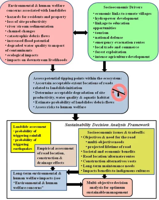
Moving forward, there is an urgent need to develop a systems-based approach for more sustainable mountain road development before tipping points are reached in these ecosystems. In northwestern Yunnan, this would include de-tailed landslide hazard assessments prior to road planning and construction activities. Ideally, such analyses should identify the probability of exceeding landslide trigger thresh-olds (in this area, largely rainfall) coupled with estimates of decreased slope stability associated with different road lo-cations and construction techniques (Fig. 8). This approach would allow for tradeoffs between socioeconomic devel-opment and long-term environmental and human welfare impacts by articulating acceptable levels of landslide ero-sion, with an eye towards avoiding tipping points where site productivity, human welfare, ecological attributes, flood-ing, and aquatic habit are not compromised in the long term. Tradeoffs for road development could include alterna-tive locations and construction techniques, assessing “storm-proofing” roads vs. continual widening and maintenance, considering multiple road uses, incorporating climate change impacts, and reevaluating the necessity of the road. In par-ticular, road location strategies can go a long way towards ameliorating landslide problems; these include (1) optimiz-ing the expected lifetime of the road with uses; (2) ensuroptimiz-ing a balance of minimizing road length and minimizing steep gradients; (3) avoiding deep cuts into unstable substrate (es-pecially bedrock dipping parallel to the hillslope); (4) uti-lizing valley bottom and ridge-top roads whenever feasible; (5) avoiding seasonally wet areas (e.g., hollows); (6) reduc-ing the width of mid-slope roads; (7) avoidreduc-ing crossreduc-ing old landslides, particularly undercutting the toe or loading the head of dormant failures; (8) rolling roads to fit hillslope contours and across drainage culverts; and (9) minimizing stream crossings (Megahan et al., 1978; Sidle and Ochiai,
Figure 8. Decision framework for sustainability assessment of mountainous terrain in northwestern Yunnan, China, where extensive road construction is being proposed (modified extensively from Sidle et al., 2013).
2006). Furthermore, planting deep rooted woody vegetation on road fills can enhance long-term stability (e.g., Stokes et al., 2009). Such a systems-based approach that considers all possible road uses and benefits against environmental and human welfare costs (Fig. 8) offers a much more robust and sustainable alternative.
Multi-criteria decision analysis has been applied to simi-lar ecosystem sustainability challenges in which cost/benefit tradeoffs need to be assessed jointly among environmental, social, and economic objectives (e.g., Linkov et al., 2006; Macleod et al., 2007). Throughout much of mountainous Southeast Asia, benefits associated with secondary road de-velopment that need quantification include (1) opening eco-nomic markets for goods and services produced in remote
mountain villages; (2) tourism opportunities; (3) access to hydroelectric generation facilities; (4) educational opportu-nities; (5) emergency evacuation; and (6) defense of na-tional borders. Cost assessment associated with mountain road development should focus on (1) environmental im-pacts of hydroelectric power facilities, increased tourism, and forest exploitation; (2) direct impacts of road-related land-slides on settlements, sediment loads in rivers, water qual-ity, and aquatic habitat; (3) loss of site productivity on hill-slopes affected by landslides; (4) impacts of relatively clean and contaminated sediments in downstream water supplies; (5) effects on channel conveyance, flooding and potential de-bris flows; (6) siltation of existing reservoirs; and (7)
en-vironmental consequences of unintended forest exploitation (Fig. 8).
Successful implementation of multi-criteria decision anal-yses related to road development and associated environ-mental and natural resources planning in this region will re-quire the engagement of diverse stakeholders with govern-ment planning agencies, donor organizations, and science ex-perts. An important aspect of this analysis is the need to in-corporate landslide risk associated with extreme events – i.e., storms or other triggers like earthquakes. This will require better spatial and temporal coverage of precipitation in the region. Furthermore, some of the consequences associated with ecosystem tipping points (e.g., floods, debris flows, veg-etation changes, aquatic habitat degradation) require a proba-bilistic approach to assessment of risk. Ecosystem goods and services as well as environmental costs should be appropri-ately valued; in cases where environmental resources have no apparent market value, alternative techniques can be used (Gregory, 2000; Ananda and Herath, 2009). Inherent to the success of such a decision analysis is the concurrent engage-ment of governengage-ment planning agencies that deal with road construction, river management, catchment management (in-cluding land use), aquatic habitat and biodiversity, and eco-nomic development to resolve interagency conflicts and con-sider relevant stakeholder opinions together with scientific expertise and evidence (e.g., Macleod et al., 2007).
5 Summary and conclusions
Our investigations of landslide erosion along seven dif-ferent mountain road segments in the upper Salween River basin confirm findings from a prior study (Sidle et al., 2011) in a single tributary of the Mekong River near Weixi, Yunnan. The erosion rates measured along these seven unpaved mountain road segments (2780 to 48 238 Mg ha−1yr−1) are higher than the range documented (1410 to 33 450 Mg ha−1yr−1) along the newly constructed paved road near Weixi, Yunnan, indicating that such epic levels of landslide erosion and sedimentation are potentially widespread throughout the northern Yunnan region (albeit previously unreported). At four of the seven road segments, more than 74 % of the landslide sediment was estimated to be delivered to tributaries or the main stem of the Salween River. Landslide erosion measured along the road segment just south of Daxingdi (DXD; > 48 000 Mg ha−1yr−1) was
the highest ever documented along a mountain road corridor. At all sites, landslides on cut slopes were more numerous, but characteristically smaller than on fill slopes. Where hill-slopes were very steep below the excavated road, landslide erosion from fill slopes was greater than from cut slopes. Al-though few instances of very large landslides (> 1100 m3) were recorded, these contributed slightly less than half and slightly more than half of the respective total landslide masses from fill slopes and cut slopes. When blasting was
used for road construction and when waste rock and soil were pushed onto steep side slopes, resultant fill slope failures routed large amounts of sediments into channels. In many cases, prudent planning and construction measures could have greatly reduced these landslides and the resultant sedi-ment delivery. At most of these sites, road location and lay-out did not adequately consider avoidance of wet areas, the need for proper drainage, avoidance of deep cuts into unsta-ble bedrock sequences, minimizing road width, and avoid-ance of steep and unstable slopes (particularly downslope of the road). With respect to construction, careful removal of earth materials with hydraulic excavators can greatly reduce the disturbed footprint of the road and waste material can be disposed at more stable sites or carefully compacted and in-corporated into the road prism.
With the high level of road-related landslide sediment al-ready being transported into the Salween River, a more sus-tainable approach is needed to assess future road system de-velopment. A decision tool is needed that includes a rather detailed analysis of landslide susceptibility based on how thresholds for landslide triggers (i.e., rain events) would be modified by various road locations and different construc-tion techniques. In this systems-based analysis, one could assess tradeoffs amongst socioeconomic benefits of road networks against costs of protecting long-term human wel-fare, environmental attributes, and site productivity. Multi-criteria decision analysis could be employed to properly as-sess the road-related sediment issue in the context of alter-native practices and other land uses. This systems-based ap-proach needs to be embraced by local governments, environ-mental groups, NGOs, and international organizations and donors, who seem to be focusing almost exclusively on the socioeconomic benefits of roads in this developing mountain-ous region. Countries located downstream of China within the Salween River basin (Myanmar and Thailand), as well as the other two major river basins in Yunnan (Mekong and Jin-sha rivers – Thailand, Cambodia, Laos, and Vietnam), need a sufficient supply of clean water to support livelihoods and de-velopment. Trans-boundary sediment issues associated with recent road construction in Yunnan pose serious problems for downstream users. Clearly, a paradigm shift is needed to em-brace the concepts of sustainability in conjunction with road development in northwestern Yunnan, as well as in other po-tentially unstable mountain environments.
Acknowledgements. This project was supported by funding from the French National Institute for Agricultural Research (INRA, Jeune Equipe) and the BMU (Germany) International Climate Initiative funded project “Ecosystems Protecting Infrastructure and Communities” (EPIC, coordinated by IUCN and ProAct, Switzerland). Gratitude is expressed to K.-F. Cao (XTBG and the University of Guangxi, China), W. Ma (Kunming Institute of Botany, China) and F.-X. Mine (ISARA, France), for assistance in field investigations and, logistics and to Lourdes Prieto for preparing the site map. This document has been reviewed in
accordance with US Environmental Protection Agency policy and approved for publication. The opinions presented herein are those of the authors and do not represent US EPA, ONCFS, INRA, or University of the Sunshine Coast.
Edited by: K. Chang
Reviewed by: four anonymous referees
References
Ananda, J. and Herath, G.: A critical review of multi-criteria de-cision making methods with special reference to forest manage-ment and planning, Ecol. Econ., 68, 2535–2548, 2009.
Balisacan, A. M.: Averting hunger and food insecurity in Asia, in: Rep. FAO-SEARC Regional Workshop, Policy issues and invest-ment options to avert hunger and food insecurity in Asia, FAO Regional Office for Asia and the Pacific, Bangkok, Thailand, 11–31, 2005.
Bansal, R. C. and Mathur, H. N.: Landslides – the nightmare of hill roads, Soil Conserv. Digest, 4, 36–37, 1976.
Burroughs, E. R., Chalfant, G. R., and Townsend, M. A.: Slope sta-bility in road construction, US Dept. of Interior, BLM, Portland, OR, p. 102, 1976.
Castella, J.-C., Manh, P. H., Kam, S. P., Villano, L., and Tronche, N. R.: Analysis of village accessibility and its impact on land use dynamics in a mountainous province of northern Vietnam, Appl. Geogr., 25, 308–326, 2005.
Chassie, R. G. and Goughnour, R. D.: National highway landslide experience, Highway Focus, 8, 1–9, 1976.
China Road Construction Report: China road construction report, 2007–2008, Beijing Waterwood Technologies CO, Ltd, Beijing, China, p. 62, 2008.
Douglas, I., Bidin, K., Balamurugan, G., Chappell, N. A., Walsh, R. P. D., Greer, T., and Sinun, W.: The role of extreme events in the impacts of selective tropical forestry on erosion during harvest-ing and recovery phases at Danum Valley, Sabah, Philos. T. Roy. Soc. Lond., 354, 1749–1761, 1999.
Eckholm, E.: Planting for the future: forestry for human needs, Worldwatch Paper 26, Worldwatch Inst., Washington, D.C., 64 pp., 1979.
Fleming, R. W. and Taylor, F. A.: Estimating the cost of landslide damage in the United States, US Geol. Surv. Circular 832, p. 21, 1980.
Ghestem, M., Stokes, A., Cao, K., Ma, W., and Xie, J.: Using veg-etation to stabilize steep slopes in Southern China: root biome-chanics as a factor in the choice of species, edited by: Thibault, B., in: Proc. 6th Plant Biomechanics Conference, 16–21 Novem-ber, Cayenne, France, 450–455, 2009.
Ghestem, M., Cao, K. F., Atger, C., Gadenne, C., Ma, W., Os-man, N., Leclerc, R., Rowe, N. P., and Stokes, A.: A frame-work for identifying plants to be used as ecological engi-neers for fixing soil on unstable slopes, PLoS One, 9, E95876, doi:10.1371/journal.pone.0095876, 2014.
Gregory, R. S.: Valuing environmental options: a case study com-parison of multi-attribute and contingent valuation survey meth-ods, Land Econ., 76, 151–173, 2000.
Haigh, M. J.: Landslide prediction and highway maintenance in the Lesser Himalayas, India, Z. Geomorph. NF, 51, 17–37, 1984.
Hettige, H.: When do rural roads benefit the poor and how?, Asian Development Bank, Manila, Philippines, p. 95, 2006.
Holtz, R. D. and Schuster, R. L.: Stabilization of soil slopes, in: Landslides – Investigation and Mitigation, Special Report 247, edited by: Turner, A. K. and Schuster, R. L., Transportation Re-search Board, National ReRe-search Council (US), National Aca-demic Press, Washington, D.C., 439–473, 1996.
Krongkaew, M.: The development of the Greater Mekong Subre-gion (GMS): real promise or false hope?, J. Asian Econ., 15, 977–998, 2004.
Linkov, I., Satterstrom, F. K., Kiker, G., Seager, T. P., Bridges, T., Gardner, K. H., Rogers, S. H., Belluck, D. A., and Meyer, A.: Multicriteria decision analysis: a comprehensive decision ap-proach for management of contaminated sediments, Risk Anal., 26, 61–78, 2006.
Ma, X., Lu, X. X., van Noordwijk, M., Li, J. T., and Xu, J. C.: Attribution of climate change, vegetation restoration, and engi-neering measures to the reduction of suspended sediment in the Kejie catchment, southwest China, Hydrol. Earth Syst. Sci., 18, 1979–1994, doi:10.5194/hess-18-1979-2014, 2014.
Macleod, C. J. A., Scholefield, D., and Haygarth, P. M.: Integration for sustainable catchment management, Sci. Total Environ., 373, 591–602, 2007.
Marshall, H.: Consultancy mission report on natural resources management, UNDP/FAO Consultancy Mission Report SPPD – DP/MYA/98/003, FAO, Bangkok, 1999.
Megahan, W. F.: Reducing erosional impacts of roads, in: Guide-lines for Watershed management, FAO Conservation Guide, UN Food and Argic. Organ., Rome, 237–251, 1977.
Megahan, W. F., Day, N. F., and Bliss, T. M.: Landslide occurrence in the western and central Northern Rocky Mountain physio-graphic province in Idaho, in: Proc. 5th North Am. Forest Soils Conf., Colo. State Univ., Ft. Collins, CO, 116–139, 1978. Mills, K.: Forest roads, drainage, and sediment delivery in the
Kilchis River watershed. Oregon Dept. of Forestry, Salem, OR, p. 21, 1997.
Nyaupane, G. P., Morais, D. B., and Dowler, L.: The role of com-munity involvement and number/type of visitors on tourism im-pacts: A controlled comparison of Annapurna, Nepal and North-west Yunnan, China, Tourism Manage., 27, 1373–1385, 2006. Rice, R. M.: Erosion on logging roads in Redwood Creek,
north-western California, J. Am Water Resour. Assoc., 35, 1171–1180, 1999.
Sakakibara, H., Kajitani, Y., and Okada, N.: Road network robust-ness for avoiding functional isolation in disasters, J. Transport Eng.-ASCE, 130, 560–567, 2004.
Sidle, R. C.: Comments on “Predicting soil erosion for alternative land uses” by E. Wang, C. Xin, J. R. Williams, and C. Xu, J. Environ. Qual., 35, 459–467, 2006.
Sidle, R. C. and Ochiai, H.: Landslides: Processes, Prediction, and Land Use, Am. Geophysical Union, Water Resour Monogr No. 18, AGU, Washington, D.C., p. 312, 2006.
Sidle, R. C. and Ziegler, A. D.: The dilemma of mountain roads, Nat. Geosci., 5, 437–438, doi:10.1038/ngeo1512, 2012. Sidle, R. C., Pearce, A. J., and O’Loughlin, C. L.: Hillslope
Stability and Land Use, Am. Geophysical Union, Water Re-sour. Monogr. 11, Washington, D.C., p. 140, 1985.
Sidle, R. C., Sasaki, S., Otsuki, M., Noguchi, S., and Abdul Rahim, N.: Sediment pathways in a tropical forest: effects of logging roads and skid trails, Hydrol. Process., 18, 703–720, 2004. Sidle, R. C., Ziegler, A. D., Negishi, J. N., Abdul Rahim, N., Siew,
R., and Turkelboom, F.: Erosion processes in steep terrain – Truths, myths, and uncertainties related to forest management in Southeast Asia, Forest Ecol. Manage., 224, 199–225, 2006. Sidle, R. C., Ziegler, A. D., and Vogler, J. B.: Contemporary
changes in open water surface area of Lake Inle, Myanmar: pos-sible causes, Sustain. Sci., 2, 55–65, 2007.
Sidle, R. C., Furuichi, T., and Kono, Y.: Unprecedented rates of landslide and surface erosion along a newly constructed road in Yunnan, China, Nat. Hazards, 57, 313–326, 2011.
Sidle, R. C., Benson, W. H., Carriger, J. F., and Kamai, T.: A broader perspective on ecosystem sustainability: consequences for decision-making, P. Natl. Acad. Sci. USA, 110, 9291–9208, 2013.
Stokes, A., Atger, C., Bengough, A. G., Fourcaud, T., and Sidle, R. C.: Desirable plant root traits for protecting natural and engi-neered slopes against landslides, Plant Soil, 324, 1–30, 2009. Su, Y., Xu, J., Wilkes, A., Lu, J., Li, Q., Fu, Y., Ma, X., and
Grumbine, R. E.: Coping with climate-induced water stresses through time and space in the mountains of Southwest China, Reg. Environ. Change, 12, 855–866, 2012.
Tullos, D. D., Foster-Moore, E., Magee, D., Tilt, B., Wolf, A. T., Schmitt, E., Gassert, F., and Kibler, K.: Biophysical, socioeco-nomic, and geopolitical vulnerabilities to hydropower develop-ment on the Nu River, China, Ecol. Soc., 18, 16, doi:10.5751/ES-05465-180316, 2013.
UNESCO: Programme of Man and the Biosphere, Working Group on Project 6: Impact of human activities on mountain and tundra ecosystems, MAP Report Series No. 14, Paris, 20–21, 1974. UNESCO: Decisions adopted by the 27th session of the World
Heritage Committee in 2003, WHC-03/27.COM/24, UNESCO World Heritage Centre, Paris, p. 179, 2003.
Urban, F., Nordensvärd, J., Khatri, D., and Wang, Y.: An analysis of China’s investiment in hydropower sector in the Greater Mekong Sub-Region, Environ. Dev. Sustain., 15, 301–324, 2013. van de Walle, D.: Choosing rural road investiments to help reduce
poverty, World Develop., 30, 575–589, 2002.
Volk, P., Heymann, J., Saradeth, S., Bechstedt, H. D., Löffler, E., Stuurman, W., Aiblinger, S., Carl, S., Küpper, A., Lamprecht, S., Ringenberg, H., and Schönberg, A.: Mapping and land use plan-ning for watershed management, Final report for the government of Myanmar, Ministry of Forestry, GAF, Munich, 1996. Wasson, R. J., Juyal, N., Jaiswal, M., McCulloch, M., Sarin, M.
M., Jain, V., Srivastava, P., and Singhvi, A. K.: The mountain-lowland debate: Deforestation and sediment transport in the up-per Ganga catchment, J. Environ. Manage., 88, 53–61, 2008. Wemple, B. C., Swanson, F. J., and Jones, J. A.: Forest roads and
geomorphic process interactions, Cascade Range, Oregon, Earth Surf. Proc. Land., 26, 191–204, 2001.
Ziegler, A. D., Giambelluca, T. W., Sutherland, R. A., Nullet, M. A., Yarnasarn, S., Pinthong, J., Preechapanya, P., and Jaiaree, S.: Toward understanding the cumulative impacts of roads in upland agricultural watersheds of northern Thailand, Agric, Ecosyst. En-viron., 104, 145–158, 2004.
Ziegler, A. D., Bruun, T. B., Guardiola-Claramonte, M., Giambel-luca, T. W., Lawrence, D., and Nguyen, T. L.: Environmental consequences of the demise in swidden cultivation in montane mainland Southeast Asia: hydrology and geomorphology, Hu-man Ecol., 37, 361–373, 2009.
Ziegler, A. D., Sidle, R. C., Song, M. S., Ang, Z. J., and Duangnamon, D.: Towards better design and management of tsunami evacuation routes: a case study of Ao Jak Beach Road, Geol. Soc. London Special Publ., London, UK, 2012.