HAL Id: halshs-00458067
https://halshs.archives-ouvertes.fr/halshs-00458067
Submitted on 19 Feb 2010HAL is a multi-disciplinary open access
archive for the deposit and dissemination of sci-entific research documents, whether they are pub-lished or not. The documents may come from teaching and research institutions in France or abroad, or from public or private research centers.
L’archive ouverte pluridisciplinaire HAL, est destinée au dépôt et à la diffusion de documents scientifiques de niveau recherche, publiés ou non, émanant des établissements d’enseignement et de recherche français ou étrangers, des laboratoires publics ou privés.
A metageography of port-city relationships
César Ducruet
To cite this version:
César Ducruet. A metageography of port-city relationships. Ashgate. Ports, cities, and global supply chains, Ashgate, pp.157-172, 2007, Transport and mobility. �halshs-00458067�
A metageography of port-city relationships
César DucruetPublished in: Wang J.J., Olivier D., Notteboom T.E., Slack B. (Eds.) Ports, Cities, and Global Supply Chains, Aldershot, Ashgate, pp. 157-172
Abstract
This chapter is an empirical attempt to identify the nature and regional dimension of port-city relationships on a world scale. Although general processes of such relationships can be identified in the literature, regional variations are still not well understood when dealing with the insertion of port cities in the global transport chain. An analysis of a world sample is proposed using simple characteristics such as geographical coordinates, urban population, logistic activities, port infrastructures, maritime traffic and transport connections. Factors of port hierarchy, land/sea, port/city, and logistic/intermodal oppositions create north-south and east-west patterns. An equilibrate insertion between different functions or networks gives a sustainable position to some port cities within the transport chain. Finally, this chapter serves as an experimental complement to the study of world regionalisation and global-local processes.
Keywords: Containerisation, Globalisation, Port city, Regionalisation, Transport chain
1. Introduction
It is now generally recognized that maritime networks have had an increasing influence on ports and port-city relationships over the last three decades, following the container revolution and the new spatial distribution of industrial activities. Although containerisation has spread globally and homogenously, it has also encountered a regional diversity of heritages and practices. The responses of port cities to global economic change reveal important differences between world regions, notably in terms of waterfront redevelopment in Europe and America
2003). Thus, transport players that are willing to insert the port city within the global transport chain must cope with normalised logistic systems which are managed by an ever-reducing number of powerful global companies (e.g., shippers, shipping lines, freight forwarders, logistic agents) and local and regional specificities in terms of economic development and spatial planning. Between global insertion and local impediments, a wide variety of situations can be found.
This chapter seeks to determine whether or not homogenous port regions exist, and, if so, what factors define such regions from arbitrary spatial divisions (Braudel, 1979; Lewis and Wigen, 1997). Studies on the world system and regionalisation have not paid much attention to ports (Lloyd, 1992; Durand et al., 1993; Dollfus et al., 1999); while most studies focus on the world‟s largest cities when examining transport globalisation (Dogan, 1988; Keeling, 1995). Port geographers have addressed a number of models usually separating developed and developing countries at different periods from colonial cities to global logistics (see Lee et al., 2006 for a synthesis), but their application has remained limited to collections of case studies rather than macro-regional or global analysis (Slack et al., 2000).
In this respect, port cities seem to be an original ground on which to study the local and regional factors affecting globalisation. Important contemporary changes have been widely described by scholars, such as the decline of mutual economic benefits (Benacchio et al., 2001) and the increased spatial separation (Hoyle, 1989) between ports and cities resulting from technological and managerial change in global transportation. In order to verify the linkages between global and local factors affecting port cities, a large-scale analysis is needed. This research analyses the relationships between functional attributes (demographic size, logistic activities, port infrastructures, traffics and land-sea connections) and locational attributes (latitude, longitude), so as to test the hypothesis of a regional coherence underlying the insertion of port cities in the global transport chain. Previous works have been limited in
undertaking such verification without the inclusion of geographical attributes (Ducruet, 2004a; Ducruet and Jeong, 2005). Geographical coordinates appear to be the only objective parameter available to express a regional belonging. It has the advantage of being neutral and unique to every place, and also it avoids the subjective definition of regional entities.
2. Models of port-city relationships
The port city does not refer to a specific scientific category or methodology, because of the diversity of port-city issues and the usual separation of port and urban studies (Broeze, 1989; Reeves, 1989; Chaline, 1994; Morvan, 1999). Thus, it is still an “unidentified real object” (Brunet, 1997) which, without a universally recognised definition, remains only broadly addressed by scholars as a circulation node between land and sea where specific functions develop (Bastié and Dezert, 1980; Brunn, 1983; White and Senior, 1983; Brocard, 1994).
2.1 Urban and port models
In port and maritime geography, the city has been given particular importance dating back to the works of Vigarié (1979). However, urban-related issues are often disregarded in the general literature on ports and transport (Banister, 1995), which is more focused on technical (network and node performance) and/or institutional (transport players and their strategies) issues. Reasons for this focus include the traditional separation between urban geography and transport geography and the contemporary phenomenon of port-city separation which has become a very fertile ground for waterfront-related issues among planners, geographers, and economists.
The city appears to be a constraint to port expansion because of the technological transformations in the maritime world (e.g., the growing size of ships). The outports depicted by Perpillou (1959) and systematised in the anyport (Bird, 1963) and European estuary
(Brocard et al., 1995) models show the shift of port facilities from the upstream city to deep-sea downstream locations. Hoyle (1989) also illustrates the successive stages of port-city spatial separation.
Urban functions are considered secondary factors to explain the strategies of shipping lines, port operators and freight forwarders which focus on cost and time efficiency of transport systems regardless of the location of port infrastructures. Additional issues regarding dry ports and inland multimodal platforms tend to reinforce the idea of the urban constraint within coastal cities. Port models have doubted the local benefits of new port facilities, like in the case of remotely located ports (Stern and Hayuth, 1984).
The port is also poorly represented in urban models. Port function is often considered as disturbing the regularity of the central place theory, due to its effect on the urban system (Bird, 1977). Thus, it has been neglected for a long time, for instance at the local level in urban models (Gleave, 1997). At least port activities confer to the economic structure some specialisation in transport functions, with a higher share of employment in the transport sector than in non-port cities.
For such reasons, port cities have often lower ranking in urban classifications (Hautreux and Rochefort, 1963; Noin, 1974; Pumain and Saint-Julien, 1976). Bird (1973) reacts to this by considering gateway and central place functions as equally important for cities and regions. Such argument was further developed through the idea of multiplier effects, described by Vigarié (1979) as a “reciprocal breed” between ports and cities. Vallega (1983) also developed a theory on the interaction between port growth and local economic diversification, even though port and urban dynamics remain of a different nature. More recent researchers still consider ports as advantageous locations for trade and urban development (Fujita and Mori, 1996; Fujita et al., 1999). The everlasting debate about the direction of the influence between ports and urban systems (Boyer and Vigarié, 1982) raises the problem of causality:
“does the port develop the city and its economic activities, or is the city the engine of port expansion ?” (Verlaque, 1979). Goss (1990) condemns this question, arguing that “it serves no useful purpose to ask which functions came first or are the more important: they go together.”
2.2 The port-city matrix
The absence of a universal definition or model of port-city relationships is balanced by several typologies, of which the port-city matrix is a synthesis. In Figure 1, an upper left – lower right diagonal illustrates the hierarchical combination of centrality1 and intermediacy (Fleming and Hayuth, 1994) while the lower left – upper right one marks their opposition. The cityport, as defined by Hoyle and Pinder (1981, 1992) is a state of equilibrium between the coastal town and the global port city in terms of size and between the hub and the general city in terms of function. This underlines the fact that, in reality, few port cities might be considered cityports because of the recurrent disequilibria between these two main orientations.
[INSERT FIGURE 1 ABOUT HERE]
3. A global approach
Most port studies on a world scale are limited to port traffics (Marcadon, 1995; Brocard et al., 1995), while others use original methodologies such as the application of graph theory to maritime systems (Joly, 1999), and the calculation of a weekly containerised transport capacity from the main shipping lines‟ services (Frémont and Soppé, 2003). Port-city
1
relationships are more developed in regional studies but few of them have a methodological framework.
3.1 Regional studies
Regional-based studies have allowed us to understand Asian (Basu, 1985; Broeze, 1989, 1997), Atlantic (Knight and Liss, 1991; Konvitz, 1994), and European (Konvitz, 1978; Hoyle and Pinder, 1992; Lawton and Lee, 2002) trends. In particular, some authors have valued the unique combinations of global and local trends taking place within port regions, notably in Asia, through particular land patterns (Mc Gee, 1967) and hinterlands (Banga, 1992), the effects of dense urban environments on port activities (Ness and Tanigawa, 1992), the urban-oriented policies of Asian port cities (Okuno, 2000), the evolution of the port-city interface in hub port cities (Lee, 2005), and the new trend of port back-up area development (Lee et al., 2005). A comparison of main port regions is shown in Figure 2, to illustrate the varying importance of inland and coastal hinterlands in terms of market centrality (Lee et al., 2006).
[INSERT FIGURE 2 ABOUT HERE]
Studies at a national level provide very different results. In India, for example, the linear correlation between demographic size and total port throughput has diminished dramatically between 1911 and 1981 (Kidwai, 1989) due to the emergence of specialised ports from big cities (e.g. New Mangalore, Paradip). Inversely, in Canada (Slack, 1989) and Australia (O‟Connor, 1989), city size and port throughput are strongly correlated with transport activities. The French case (Steck, 1995) does not show any correlation between urban and port growth during the 1975 to 1990 period. In addition, the growth rates in Europe of added value were identical between port cities and non-port cities between 1975 and 1985, but
became stronger for non-port cities between 1985 and 1996 (Lever, 1994), illustrating the economic advantage of inland location in the European central place system (IRSIT, 2004). In China, although new ports are distant from inner cities, they become industrial growth poles while port activity is still important for inner ports (Wang and Olivier, 2003).
3.2 Measuring port-city relationships
The lack of relevant sources for measuring these relationships through international comparisons (Ducruet, 2003) has restrained the quantitative approach to “approximate measures of economic benefits deriving from port activities” (Wang and Olivier, 2003). In fact, port-city relationships are more of a qualitative issue but a number of authors have proposed some indicators to allow a comparative approach.
The relative concentration index is proposed by Vallega (1976) to compare Mediterranean regions, by simply dividing the regional share of throughput by the regional share of population. Similar index are used by Vigarié (1968) to measure maritime dependence (number of merchant marine tons per inhabitant) and Kenyon (1974) to measure the relative importance of transit function and urban magnitude amongst US port cities (number of general cargo tons per inhabitant).
The works of Witherick (1981) and Gripaios (1995) remain based on specific data collected from national censuses. Recent works on port-related employment in British travel-to-work areas (Gripaios and Gripaios, 1999), air-sea employment in European port cities (Ducruet et al., 2005), the port-city interface in Europe and Asia (Ducruet and Jeong, 2005), and global-local forces affecting global hub port cities in Asia (Lee, 2005) have provided useful outcomes motivating the pursuit of a global approach.
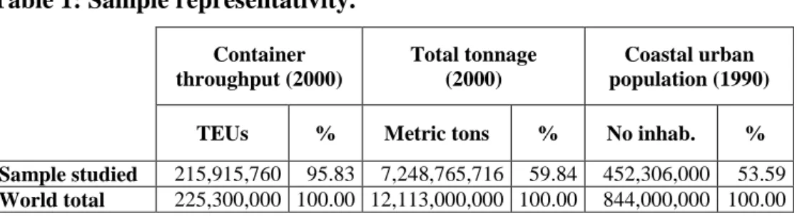
4.1 Global analysis
As a result of data collection on a world scale, the sample covers approximately 96 percent of container throughput, 60 percent of port tonnage, and 53 percent of coastal urban population (Table 1).
[INSERT TABLE 1 ABOUT HERE]
The criteria used to select ports is their participation to regular container services of the world‟s major shipping lines, regardless of a demographic or traffic size (Frémont and Soppé, 2003). This criteria has the advantage of assessing the participation of the port city to the global logistic chain. Moreover, containerisation implies a higher value of the goods transported, a potential intermodality, and a set of logistic functions which are not common with ports specialised in bulk or oil products. The resulting sample consists of 348 ports located throughout the world.
Available data have been selected through their relevancy: geographical coordinates (Lloyd‟s Maritime Atlas, 2005), urban population (Helders, 2006; Lahmeyer, 2006; Brinkhoff, 2006), container-related businesses (Containerisation International Online, 2006), freight forwarders and logistic agents (International Transport Journal, 2006), highway and railway connections (Microsoft, 2006), container throughput, maritime connections, nautical accessibility and total length of the container terminals (Containerisation International, 2006). Although other indicators exist at a global scale, they have not been included to avoid redundant values (e.g. ton traffic, total quayage, administrative and suburban population, surface of the metropolitan urbanised area, and shipowners‟ headquarters).
The original values are transformed into logarithms to lower extreme values, except for geographical coordinates, which contain negative numbers. In Table 2, eigenvalues and
cumulated variance show the results of the factor analysis with four main factors, accounting for 76% of the original information.
[INSERT TABLE 2 ABOUT HERE]
The first factor (F1) is the concentration of the transport chain, based on logistic activities, port throughputs and infrastructures. In this hierarchy, geographical coordinates do not play an important role. Then F1 can be defined as a gradient of insertion in the global transport chain.
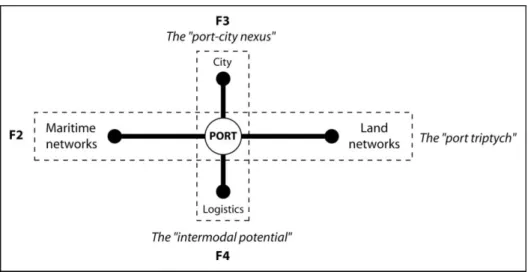
The second factor (F2) is an opposition between two trends. On one side, maritime connections and maximum depth of the container terminals are related to longitude (east-west maritime gradient), while on the other side, inland connections are related to latitude (north-south landside gradient). This opposition is recurrent in port geography, as it refers to the “port triptych” model (Vigarié, 1968) where foreland and hinterland are two major components of the transport chain, along with the port itself; few ports embrace a dominant position on both sides of the triptych. Aside these two major factors which account together for almost 60% of the analysis, two other ones worth attention.
The third factor (F3) brings a complementary opposition: on one side is the interplay of demographic size and longitude (east-west urban gradient), and on the other side is the one between container infrastructures and latitude (north-south port gradient). The opposition between city size and port performance is a recurrent issue as stated previously. It means that the efficiency of port operation contradicts the importance of the urban centre, because of growing congestion at the port-city interface. Although coastal location has been an advantage in attracting population and industries close to ports for economic reasons, the spatial effects of such concentration have increasingly led to diseconomies of scale and of agglomeration. It
also confirms in some way the opposition between the hub port, dominated by maritime shipments, and the coastal city or metropolis, dominated by central place functions (Figure 1). The north-south port gradient also recalls the works of Zohil and Prijon (1999) and Boske (2003) on the interdependence of transhipment volumes and distance to major sea lanes. Port planning on a world scale is highly influenced by the shortest path used by bigger ships, linking the three main economic poles of the world: ports located away from the circumterrestrial artery cause a deviation and are used as feeder ports instead of as direct ports of calls for mother vessels.
The fourth factor (F4) opposes two different trends: the interplay of logistic activities, population and latitude (north-south logistic gradient) and the combination of nautical, inland accessibility with longitude (east-west intermodal gradient). Urban economies are important for logistic activities, because urban systems remain the raison d‟être of production and consumption activities. If the local relationship between ports and port cities undergoes growing pains (McCalla, 1999), ports and transport players cannot ignore the markets they serve and nor their location patterns. The opposition to an intermodal potential means that the efficiency of transport systems has its own logic but, in the end, transport players are more likely to follow the urban hierarchy.
The absence of a gradient of port-city interdependence shows that on a world scale, there is more of an opposition than a combination of urban and port functions.
4.2 Regional analysis
The spatial distribution of the gradient of transport chain concentration (F1) reveals the three dominant economic regions: North America, Europe and East Asia (Figure 3a). The cores of the world economy are also in the south: Callao-Lima, Buenos Aires, Rio de Janeiro, Abidjan, Capetown, Durban, Australian cities, Auckland, and the important metropolises of the Middle
East (Jeddah, Dubai) and South Asia (Karachi, Mumbai, Colombo, Visakhapatnam). These port cities are the most connected to the global transport chain although the principles of their insertion differ in terms of market centrality and urban systems (as shown in Figure 2). Thus, unsurprisingly, the organisation of global logistics corresponds to the world pattern of economic wealth and port concentration, dividing the world into two distinct hemispheres.
[INSERT FIGURE 3 ABOUT HERE] [INSERT FIGURE 4 ABOUT HERE]
The first opposition (F2) reveals the contemporary shift of maritime and port activities to the East, the new gravity centre of the world economy (Figure 3b). Thus, the concentration of shipping lines and modern port infrastructures follows an east-west gradient, with most important scores located in East Asia. It also indicates the lack of inland connections, a main characteristic of Asian ports resulting from the extraversion of port activities and the coastal concentration of markets (Figure 2). Inversely, for the Western (Atlantic) world, the concentration of shipping lines is lower and the importance of inland connections is higher. This is particularly true for North America as well as for Europe, where ongoing regional integration is mostly based on the interaction between EU member countries within the continent. It also confirms that North America and Europe are more continental while Asia is more maritime.
The second opposition (F3) shows a complementary reality (Figure 4a). The east-west gradient shows the importance of city size in South and Southeast Asia (from Karachi to Manila), Oceania, Western and Southern Africa, and to a lesser extent in Northeast Asia and South America. In other regions, city size is relatively less important than port functions; this indirectly indicates the fact that Western urban economies have also developed inland,
especially in Europe where the heartland of the continent is the core of the regional economy. Thus, European port cities compete to sustain their accessibility and welcome the highest cargo volumes for serving overlapping hinterlands.
The third opposition (F4) has a more complex spatial distribution (Figure 4b). Broadly speaking, the east-west intermodal gradient concentrates on port cities along the circumterrestrial trunk line: Caribbean, West and North Africa, East Mediterranean, and South and East Asia. The north-south logistic gradient lies north or south of this trunk line with South America, Northeast America, Western Europe, Japan and Oceania. Although the two gradients exclude each other, the importance of logistic activities in Europe does not mean a lack of intermodal potential. This trend can be explained by the historical importance of logistic activities in Europe, alike Japan and Northeast America. In other regions sharing this trend, the lack of intermodal potential is probably the main explanation. Thus, the remoteness to major shipping lines lowers the need for intermodal operations but accentuates the importance of local economies and logistics.
4.3 Exceptions
According to the east-west maritime gradient (F2), any port city located westbound of the Greenwich meridian should indicate a relatively lesser concentration of shipping lines compared to the level of its landside connections. This is not true for some port cities of the Caribbean (Kingston, Puerto Cabello, Cartagena, Colon) and South America (Rio Grande, Paranagua, Sao Francisco do Sul, Santos, Sepetiba, Suape). In Europe, port cities located close to the heartland also contradict the trend, like those of the Northern range (Le Havre, Zeebrugge, Rotterdam, Tilbury, Felixstowe), northern Italy (Genoa, La Spezia, Venice, but also Koper in Slovenia) and the Mediterranean hubs (Algeciras, Gioia Tauro, Marsaxlokk, Piraeus, Limassol). Their direct connection to the global economy through the world‟s major
shipping lines overwhelms the importance – or accentuates the lack - of inland connections. In contrast, some port cities located eastbound of the Greenwich meridian have a lower concentration of shipping lines compared to the importance of their inland connections, such as Japanese and South Asian port cities (e.g., Bangkok, Chittagong, Yangon, Visakhapatnam, Batangas). For Japan, this can be explained by the absence of one unique load centre and to its Western character due to earlier industrialisation than other Asian countries.
Similarly, the north-south landside gradient is not matched by several south American port cities (Paita, Ilo, Chanaral, Caldera, Coquimbo, Buenos Aires, San Lorenzo, Montevideo, Rio de Janeiro, Ilheus, Recife, Fortaleza, Belem, Georgetown, Degrad-des-Cannes, Guanta, Maracaibo). Such exceptions are not found in Oceania, despite the distance to major shipping lines, because of the insular character of the port cities.
According to the east-west urban gradient (F3), port cities located westbound of the Greenwich meridian should see their city size less important than their port functions. Again, South America has several exceptions (most Brazilian cities, Talcahuano, and Coquimbo). Some Eastern cities show a lesser importance of city size as compared to their port functions (Laem Chabang, Jawaharlal Nehru, Port Mohammad Bin Qasim); these ports were recently created to reduce the congestion problems in their older neighbours (Bangkok, Mumbai, Karachi).
The distribution of the north-south port gradient (F3) is contradicted by several UK (Cardiff, Belfast, Glasgow, Edinburgh, Tyne, Hull, London) and Baltic (Copenhagen, Malmo, Rostock, Szczecin, Stockholm, Gdansk, Riga, Klaipeda, Saint-Petersburg) port cities, as well as in the south (Bordeaux, Sevilla, Malaga, Alicante, Algiers, Tunis, Messina, Bari, Volos, Thessaloniki, Izmir, Istanbul, Varna). Economic diversification, remoteness to major shipping lines, and congestion at the port-urban interface are main factors which explain the precedence taken by urban functions over port functions.
The last factor (F4) shows the spatial division of Europe, with logistic importance in the west and intermodal potential in the east. The logistic importance may correspond to the strategies of operators, to concentrate on few dominant ports to serve the continent.
5. Policy implications: strengths and weaknesses of port cities
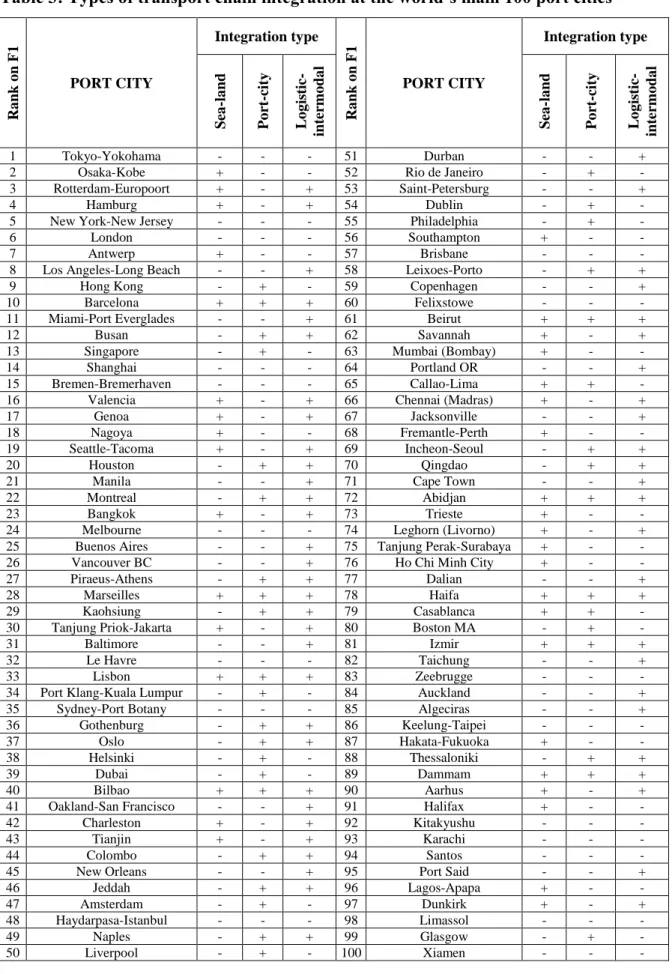
Although the factor analysis shows the different oppositions of variables and regions, an important question remains: how do port cities integrate land and sea networks? Port and urban functions? Logistic activities and intermodal potentials? Because the particularity and efficiency of a port city is more to combine different elements of the transport chain in a single place, a complementary approach is needed. The lower the contribution of a port city to an opposition between two trends, the higher its participation to both opposing trends will be. Port cities having less than 0.1 per cent contribution to a factor are considered more equilibrate within different functions and networks. A selection is proposed in Table 3, with (+) for contributions under 0.1 percent (equilibrium) and (-) for contributions above 0.1 percent (disequilibria). Results are interpreted as strengths or weaknesses regarding the insertion of port cities in the transport chain, with Figure 5 as a framework.
[INSERT FIGURE 5 ABOUT HERE]
Port-city integration in Europe is observed only for places located away from the heartland (Amsterdam, Liverpool, Dublin, Glasgow, Gothenburg, Oslo, Lisbon, Leixoes, Naples, Piraeus, Thessaloniki). European gateways are more efficient for triptych and intermodal integration (Rotterdam, Hamburg, Aarhus, Dunkirk, Southampton, Trieste, Genoa, Valencia, Leghorn). This confirms that the closer that ports are close to the heartland, the less their
port-city equilibrium will be realised, given the concentration of flows and the indirect dependence on inland markets, which accentuates port specialisation.
Elsewhere, port-city integration reveals the specificity of Asian hub port cities (Hong Kong, Singapore, Port Klang) combined with intermodal logistics (Busan, Incheon, Qingdao, Kaohsiung, Colombo). Such cities manage to keep a profitable equilibrium between urban and port functions by overcoming the risk of congestion at the port-city interface but suffer from the lack of hinterland. Except for hub port cities, Asian places are mostly concerned with port triptych integration (Osaka, Nagoya, Hakata), which combines with intermodal logistics in the case of south-eastern metropolises (Bangkok, Jakarta, Chennai) but cannot maintain a sustainable port-city equilibrium.
In North America, 13 port cities among 17 integrate logistics and intermodality, except for Halifax, New York, Boston and Philadelphia. Similar to European gateways, North American port cities have grown into powerful integrators of transport networks, allowing the formation of land bridge strategies across the continent. However, the absence of port-city integration stems from the diversity and size of local economies.
Finally, the integration of all three factors is quite rare and spatially restrained. In fact, this profile is seen only in the south European-Middle Eastern area, except for Abidjan. Lisbon, Bilbao, Barcelona, Marseilles, Izmir, Beirut, Haifa, Dammam are the only port cities to maintain a total equilibrium. Thus, they can be attributed the identity of cityports. Inversely, the total absence of integration does not have a specific geographical logic. It is more of a functional matter, like the absence of consistent local economy, inland connections and intermodal logistics (Le Havre, Zeebrugge, Felixstowe, Limassol, Keelung, Xiamen, Santos), or the dominance of urban functions combined with the lack of space (London, Tokyo, New York, Shanghai, Bremen, Brisbane, Melbourne, Sydney, Istanbul, Kitakyushu, Karachi).
These cities cannot be cityports because their situation in the transport chain gives advantage to only one of the elements of the system at a time.
[INSERT TABLE 3 ABOUT HERE]
6. Concluding remarks: the transport chain is not ubiquitous
Starting from the hypothesis that a world regionalisation underlies port-city relationships, this research has overcome the difficulty of gathering relevant data from a vast sample of port cities throughout the world. Another difficulty of such an approach is the systematic measurement of a complex phenomenon which is not well defined in the literature; port-city relationships are often hampered by the institutional and physical separation between urban and port authorities, transport modes, and operators. Far from ignoring this reality, the focus was placed on a geographical rather than on an economical perspective. Arguing that the combination of different variables in every place is not unique, this chapter searched for wider levels of organisation, where port cities face a number of common challenges inherited from similar stages of development (e.g., colonial period, first industrial revolution), physical constraints (e.g., islands and continents, distance to trunk lines) and settlement patterns (e.g., types of urban systems), defined as long-term factors.
The first part of the results verifies the respective weight of long-term and short-term factors, the latter being the strategies for inserting port cities in the global transport chain (Robinson, 2002). Unsurprisingly, long-term factors have a strong influence on the distribution of port and urban variables, which are in line with east-west and north-south patterns. This confirms the recurrent separation between port and urban functions, but this separation does not have the same meaning according to macro-regions. There are important distortions of regional
patterns, caused by recent strategies of port concentration, new port construction and hub-feeder networks.
Following the horizontal analysis, based on the search for a bi-dimensional coherence of port-city relationships, the second part of the results is more a vertical one. Although port and urban variables are systematically opposed (land/maritime, port/city, logistics/intermodality), there are several cases for which these functions are articulated. This is a useful qualitative complement to usual port rankings based on sole traffics. The synthetic expression of strengths and weaknesses of port cities addresses several policy implications. In the end, it provides some evidence about the relativity of universal issues, such as the transport chain, which are far from being ubiquitous. Results can also be a tool for port and urban players to position themselves in the world system.
References
Banga, I 1992, Ports and their hinterlands in India 1700-1950, New Delhi, Manohar. Banister, D 1995, Transport and urban development, Oxford, Alexandrine Press. Bastié, J & Dezert, B 1980, L’Espace urbain, Masson, Paris.
Basu, DK 1985, The rise and growth of the colonial port cities in Asia, Lanham, University of California.
Benacchio, M, Ferrari, C, Haralambides, HE & Musso, E 2001, „On the economic impact of ports: local vs. national costs and benefits‟, World conference on transport research, Seoul, Korea.
Bird, J 1963, The major seaports of the United Kingdom, Hutchinson of London, London. Bird, J 1973, „Of central places, cities and seaports‟, Geography, vol. 58, pp. 105-118. Bird, J 1977, Centrality and cities, Routledge Direct Editions, London.
Boyer, JC & Vigarié, A 1982, „Les ports et l‟organisation urbaine et régionale‟, Bulletin de
l’Association des Géographes Français, vol. 487, pp. 159-182.
Braudel, F 1979, Civilisation matérielle, économie et capitalisme, Armand Colin, Paris. Brinkhoff, T 2006, Cities and agglomerations of the world. http://www.citypopulation.de/
cities.html
Brocard, M 1994, „Deux villes frontières portuaires: Le Havre et Southampton‟, La Revue
d’Ici, n° 11, pp. 8-12.
Brocard, M, Joly, O & Steck, B 1995, „Les réseaux de circulation maritime‟, Mappemonde, n° 1, pp. 23-28.
Brocard, M, Lecoquierre, B & Mallet, P 1995, „Le chorotype de l‟estuaire européen‟,
Mappemonde, n° 3, p. 6.
Broeze, F 1989, Brides of the sea: port cities of Asia from the 16th-20th centuries, University
of Hawaii Press, Honolulu.
Broeze, F 1997, Gateways of Asia: port cities of Asia in the 13th-20th centuries, Kegan Paul
International, London & New York.
Brunet, R 1997, „Villes moyennes: point de vue de géographe‟, in N Commerçon & P Goujon (eds), Villes moyennes: espaces, société, patrimoine, Presses Universitaires de Lyon, Lyon, pp. 13-25.
Brunn, SD & Williams, JF 1983, Cities of the world: world regional urban development, Harper and Row Series in Geography, New York.
Carmona, M 2003, Globalization and city ports: the response of city ports in the northern
hemisphere, Delft University Press, vol. 9.
Carmona, M 2003, Globalization and city ports: the response of city ports in the southern
hemisphere, Delft University Press, vol. 10.
Containerisation International 2006, Containerisation international online. Retrieved October 12, 2006, from http://www.ci-online.co.uk/
Dogan, M 1988, Giant cities as maritime gateways, in M Dogan & JD Kasarda (eds), The
metropolis era, vol.1, SAGE Publications, London, pp. 30-55.
Dollfuss, O, Grataloup, C & Lévy, J 1999, „Trois ou quatre choses que la mondialisation dit à la géographie‟, L'Espace Géographique, n° 1, pp. 1-11.
Ducruet, C 2003, „The trans-scalar development of transportation hubs‟, Gyeongsang Nonjib vol.18, n° 2, Inha University, Institute of Business and Economic Research, pp. 171-199. Ducruet, C 2004a, „Comparing European and East Asian port cities: are global databases
relevant sources for research?‟, Gyeongsang Nonjib vol.17, n° 2, Inha University, Institute of Business and Economic Research, pp. 139-159.
Ducruet, C 2004b, Port cities, laboratories of globalisation, unpublished dissertation in geography, Le Havre University.
Ducruet, C 2005, „Approche comparée du développement des villes-ports à l‟échelle mondiale: problèmes théoriques et méthodologiques‟, Cahiers Scientifiques du Transport, vol.48, pp. 59-79.
Ducruet, C Joly, O & Martell, H 2005, „Air-sea linkages in European port cities‟, in CH Fredouet & PJ Rimmer (eds), International transport and logistics: East Asian and
European experiences, Routledge (forthcoming).
Ducruet, C & Jeong, O 2005, European port-city interface and its Asian application, Korea Research Institute for Human Settlements, Research Report 17, Anyang, Korea.
Durand, MF, Lévy, J & Retaillé, D 1993, Le monde espaces et systèmes, Dalloz, Paris.
Fleming, DK & Hayuth, Y 1994, „Spatial characteristics of transportation hubs: centrality and intermediacy‟, Journal of Transport Geography, vol.2, n° 1, pp. 3-18.
Frémont, A & Ducruet, C 2005, „The emergence of a mega port, from the local to the global, the case of Busan‟, Tijdschrift voor Econ. En Soc. Geografie, vol.96, n° 4, pp. 421-432. Frémont, A & Soppé, M 2003, „The service strategies of liner shipping companies, Maritime
transport, globalisation, regional integration and territorial development, Le Havre,
France, June 5th.
Fujita, M & Mori, T 1996, „The role of ports in the making of major cities: self-agglomeration and hub-effect‟, Journal of Development Economics, vol.49, pp. 93-120.
Fujita, M, Krugman, P & Venables, AJ 1999, The spatial economy: cities, regions and
international trade, MIT Press, Cambridge, London.
Gleave, MB 1997, „Port activities and the spatial structure of cities: the case of Freetown, Sierra Leone‟, Journal of Transport Geography, vol.5, n° 4, pp. 257-275.
Goss, RO 1990, „Economic policies and seaports‟, Maritime Policy and Management, vol.17, n° 3, pp. 207-219.
Gripaios,R 1999, „Ports and their influence on local economies: a UK perspective‟, The Dock
and Harbour Authority, pp. 235-241.
Gripaios, P & Gripaios, R 1995, „The impact of a port on its local economy: the case of Plymouth‟, Maritime Policy and Management, vol.22, n° 1, pp. 13-23.
Hautreux, J & Rochefort, M 1963, „Physionomie générale de l'armature urbaine française‟,
Annales de Géographie, n° 406, pp. 660-677.
Helders, S 2006, The world gazetteer. Retrieved October 12, 2006, from http://www.world-gazetteer.com/home.htm
Hoyle, BS 1989, „The port-city interface: trends, problems, and examples‟, Geoforum, vol.20, n° 4, pp. 429-435.
Hoyle, BS 2000, „Global and local change on the port-city waterfront‟, Geographical Review, vol.90, n° 3, pp. 395-417.
Hoyle, BS & Pinder, DA 1981, Cityport industrialization and regional development. Pergamon Press, Oxford.
Hoyle, BS & Pinder, D 1992, European port cities in transition, Belhaven Press, London. IRSIT 2004, Les villes portuaires en Europe, analyse comparative, CNRS, Montpellier. Institute of Shipping and Logistics 2001, Shipping statistics yearbook, ISL, Bremen.
International Transport Journal 2006, International register of logistics and forwarding
agents. Retrieved October 12, 2006, from http://195.65.73.10/itz/irflaNeu/e/
irfla_suche.asp
Joly, O 1999, La structuration des réseaux de circulation maritime, unpublished dissertation in territorial management, Le Havre University.
Journal de la Marine Marchande 1970-2000, Bilan annuel des ports du monde, Wolters Kluwer France & Groupe Liaison SA, Rueil Malmaison.
Keeling, DJ 1995, „Transport and the world city paradigm‟, in PL Knox & PJ Taylor (eds),
World cities in a world system, Cambridge University Press, pp. 115-129.
Kenyon, JB 1974, „Elements in inter-port competition in the United States‟, in ME Eliot (ed),
Transportation geography: comments and readings, McGraw Hill Series in Geography,
pp. 231-253.
Kidwai, AH 1989, „Port cities in a national system of ports and cities: a geographical analysis of India in the 20th century‟, in F Broeze (ed), Brides of the sea: port cities of Asia from
the 16th-20th centuries, University of Hawaii Press, Honolulu, pp. 207-222.
Knight, FW & Liss, PK 1991, Atlantic port cities: economy, culture and society in the
Atlantic world, 1650-1850, University of Tennessee Press, Knoxville.
Konvitz, JW 1978, Cities and the sea: port city planning in early modern Europe, John Hopkins University Press, Baltimore and London.
Konvitz,JW 1994, „The crisis of Atlantic port cities, 1880 to 1920‟, Comparative Studies in
Society and History, vol.36, n° 2, pp. 293-318.
Lahmeyer, J 2006, Population statistics. Retrieved October 12, 2006, from http://www.library.uu.nl/wesp/populstat/populhome.html
Lawton, R & Lee, R 2002, Population and society in Western European port cities, c.
1650-1939, Liverpool University Press, Liverpool.
Lee, SW 2005, Interaction between city and port in Asian hub port cities, unpublished dissertation in urban planning, Seoul National University.
Lee, SW, Kim, CH & Jung, HW 2005, A study of port performance related to port backup
area in ESCAP region. Korea Maritime Institute, Seoul.
Lee, SW, Song DW & Ducruet, C 2006, „A tale of Asia‟s global hub port cities: the spatial evolution in Hong Kong and Singapore‟, Geoforum (forthcoming).
Lever, WF 1994, „Regional economic growth and port activities in European cities‟, Portes
océanes et développement des territoires intérieurs, 5th International Conference Cities
and Ports, Dakar, Senegal.
Lewis, MW & Wigen, K 1997, The myth of continents: a critique of metageography, Berkeley, University of California Press.
Lloyd, PJ 1992, Regionalisation and world trade, OECD Economic Studies, n° 18. Lloyd‟s List 2001, Ports of the world 2002, Informa UK Ltd, London.
Lloyd‟s List 2005, Lloyd’s maritime atlas, Informa UK Ltd., London.
Marcadon, J 1995, „Ports et flux de conteneurs dans le monde, 1983-1992‟, Mappemonde, n° 1, pp. 29-34.
McCalla, R 1999, „Global change, local pain: intermodal seaport terminals and their service areas‟, Journal of Transport Geography, vol.7, pp. 247-254.
McGee, T 1967, The southeast Asian city: a social geography of the primate cities, London, G. Bell & Sons Ltd.
Microsoft 2006, Mappoint geographical atlas. Retrieved October 12, 2006, from http://wwwmappoint.com
Moriconi-Ebrard, F 1994, Geopolis, pour comparer les villes du monde, Economica, Paris. Morvan, M 1999, Villes portuaires: les moyens d’un développement solidaire dans une
Europe ouverte, Conférence des Villes Portuaires Périphériques, Brest.
Murphey,R 1989, „On the evolution of the port city‟, in F Broeze (ed), Brides of the sea: port
cities of Asia from the 16th-20th centuries, University of Hawaii Press, Honolulu, pp.
223-245.
Ness, GD & Tanigawa, K 1992, Population dynamics and port city development: comparative
analysis of ten Asian port cities, Kobe, Asian Urban Information Center.
Noin, D 1974, „Les activités spécifiques des villes françaises‟, Annales de Géographie, n° 459, pp. 531-544.
Noin, D 2000, „La population des littoraux du monde‟, L’Information Géographique, n° 2, pp. 65-73.
O'Connor, K 1989, „Australian ports, metropolitan areas and trade-related services‟,
Australian Geographer, vol.20, n° 2, pp. 167-172.
Okuno, S 2000, „Urban policies of some port cities in the Asia-Pacific corridor‟, in GP Chapman, RW Bradnock & AK Dutt (eds), Urban growth and development in Asia, vol.2, Ashgate, Aldershot, pp. 426-439.
Perpillou, A 1959, Géographie de la circulation. Les cours de Sorbonne, vol.1, Paris.
Pumain, D & Saint-Julien, T 1976, „Fonctions et hiérarchies des villes françaises‟, Annales de
Reeves, P 1989, „Studying the Asian port city‟, in F Broeze (ed), Brides of the sea: port cities
of Asia from the 16th-20th centuries, University of Hawaii Press, Honolulu, pp. 29-53.
Robinson, R 2002, „Ports as elements in value-driven chain systems: the new paradigm‟,
Maritime Policy and Management, vol.29, n° 3, pp. 241-255.
Slack, B 1989, „Port services, ports and the urban hierarchy‟, Tijdschrift voor Econ. En
Soc.Geografie, vol.80, n° 4, pp. 236-243.
Slack, B, Comtois, C & Lasserre, JC 2000, „Les systèmes portuaires et les villes: comparaisons entre diverses régions du monde‟, in D Patier-Marque (ed), L’intégration
des marchandises dans le système des déplacements urbains, Lyon, Laboratoire
d‟Economie des Transports, pp. 319-322.
Steck, B 1995, „Les villes portuaires dans le réseau urbain français‟, Vivre et habiter la ville
portuaire, October 12-14 1994, Plan Construction et Architecture, Paris, Rouen, Le
Havre.
Stern, E & Hayuth, Y 1984, „Developmental effects of geopolitically located ports‟, in BS Hoyle & D Hilling (eds), Seaport systems and spatial change, John Wiley and Sons, Chichester, pp. 239-249.
UNCTAD 2002, Review of maritime transport, United Nations, Geneva.
Vallega, A 1979, „Fonctions portuaires et polarisations littorales dans la nouvelle régionalisation de la Méditerranée, quelques réflexions‟, in Villes et ports, développement
portuaire, croissance spatiale des villes, environnement littoral, CNRS, Paris, pp.
355-367.
Vallega,A 1983, „Nodalité et centralité face à la multimodalité: éléments pour un relais entre théorie régionale et théorie des transports‟, in C Muscara & C Poli (eds), Transport
geography facing geography, I.G.U. Working Group on Geography of Transport, pp.
Verlaque, C 1979, „Inductions portuaires: le cas sétois‟, in Villes et ports, développement
portuaire, croissance spatiale des villes, environnement littoral, CNRS, Paris, pp.
175-180.
Vigarié,A1968, Géographie de la circulation, Genin, Paris.
Vigarié, A 1979, Ports de commerce et vie littorale, Hachette, Paris.
Wang, JJ & Olivier, D 2003, „La gouvernance des ports et la relation ville-port en Chine‟,
Cahiers Scientifiques du Transport, vol.44, pp. 25-54.
White, HP & Senior, ML 1983, Transport geography, Longman House Ltd., Hong Kong. Witherick, ME 1981, „Port developments, port-city linkages and prospects for maritime
industry: a case study of Southampton‟, in BS Hoyle & Pinder DA (eds), Cityport
Table 1: Sample representativity. Container throughput (2000) Total tonnage (2000) Coastal urban population (1990)
TEUs % Metric tons % No inhab. % Sample studied 215,915,760 95.83 7,248,765,716 59.84 452,306,000 53.59
World total 225,300,000 100.00 12,113,000,000 100.00 844,000,000 100.00
Sources: Containerisation International, ISL Statistical Yearbook, Journal de la Marine Marchande, Moriconi-Ebrard 1994, World Gazetteer, Citypopulation, Populstat, UNCTAD 2002, Noin 2000
Table 2: Main characteristics of the principal components
F1 F2 F3 F4
Eigen values 5.2 1.3 1.0 0.8
Cumulated
variance (%) 47.2 59.1 68.3 76.0
Contribution of the indicators to the factors (%)
Coordinates > 0 Transport chain concentration North-south landside gradient East-west urban gradient North-south logistic gradient Logistic Activities (14%) Container Throughput (13%) Container Terminals (12%) Freight Forwarders (12%) Rail Connections (19%) Road Connections (18%) Latitude (15%) Urban Population (3%) Longitude (51%) Urban Population (14%) Logistic Activities (3%) Rail Connections (1%) Logistic Activities (10%) Urban Population (7%) Latitude (3%) Freight Forwarders (3%) Coordinates < 0 - Container Throughput (6%) Maximum Depth (11%) Maritime Connections (11%) Longitude (13%) Container Throughput (2%) Container Terminals (5%) Latitude (7%) Maximum Depth (13%) Longitude (10%) Rail Connections (15%) Road Connections (17%) Maximum Depth (30%) East-west maritime gradient North-south port gradient East-west intermodal gradient
Table 3: Types of transport chain integration at the world’s main 100 port cities Ra nk o n F 1 PORT CITY Integration type Ra nk o n F 1 PORT CITY Integration type Sea -la nd P o rt -cit y L o g is tic -inte rmo da l Sea -la nd P o rt -cit y L o g is tic -inte rmo da l 1 Tokyo-Yokohama - - - 51 Durban - - +
2 Osaka-Kobe + - - 52 Rio de Janeiro - + -
3 Rotterdam-Europoort + - + 53 Saint-Petersburg - - +
4 Hamburg + - + 54 Dublin - + -
5 New York-New Jersey - - - 55 Philadelphia - + -
6 London - - - 56 Southampton + - -
7 Antwerp + - - 57 Brisbane - - -
8 Los Angeles-Long Beach - - + 58 Leixoes-Porto - + +
9 Hong Kong - + - 59 Copenhagen - - +
10 Barcelona + + + 60 Felixstowe - - -
11 Miami-Port Everglades - - + 61 Beirut + + +
12 Busan - + + 62 Savannah + - +
13 Singapore - + - 63 Mumbai (Bombay) + - -
14 Shanghai - - - 64 Portland OR - - +
15 Bremen-Bremerhaven - - - 65 Callao-Lima + + -
16 Valencia + - + 66 Chennai (Madras) + - +
17 Genoa + - + 67 Jacksonville - - +
18 Nagoya + - - 68 Fremantle-Perth + - -
19 Seattle-Tacoma + - + 69 Incheon-Seoul - + +
20 Houston - + + 70 Qingdao - + +
21 Manila - - + 71 Cape Town - - +
22 Montreal - + + 72 Abidjan + + +
23 Bangkok + - + 73 Trieste + - -
24 Melbourne - - - 74 Leghorn (Livorno) + - +
25 Buenos Aires - - + 75 Tanjung Perak-Surabaya + - -
26 Vancouver BC - - + 76 Ho Chi Minh City + - -
27 Piraeus-Athens - + + 77 Dalian - - +
28 Marseilles + + + 78 Haifa + + +
29 Kaohsiung - + + 79 Casablanca + + -
30 Tanjung Priok-Jakarta + - + 80 Boston MA - + -
31 Baltimore - - + 81 Izmir + + +
32 Le Havre - - - 82 Taichung - - +
33 Lisbon + + + 83 Zeebrugge - - -
34 Port Klang-Kuala Lumpur - + - 84 Auckland - - +
35 Sydney-Port Botany - - - 85 Algeciras - - +
36 Gothenburg - + + 86 Keelung-Taipei - - -
37 Oslo - + + 87 Hakata-Fukuoka + - -
38 Helsinki - + - 88 Thessaloniki - + +
39 Dubai - + - 89 Dammam + + +
40 Bilbao + + + 90 Aarhus + - +
41 Oakland-San Francisco - - + 91 Halifax + - -
42 Charleston + - + 92 Kitakyushu - - -
43 Tianjin + - + 93 Karachi - - -
44 Colombo - + + 94 Santos - - -
45 New Orleans - - + 95 Port Said - - +
46 Jeddah - + + 96 Lagos-Apapa + - -
47 Amsterdam - + - 97 Dunkirk + - +
48 Haydarpasa-Istanbul - - - 98 Limassol - - -
49 Naples - + + 99 Glasgow - + -
Figure 1: A matrix of port-city relationships
Source: adapted from Ducruet, 2004b
Figure 2: Regional models of port-urban organisation
Annex: Most representative port cities (+) North-south landside gradient East-west urban gradient North-south logistic gradient Boston Philadelphia Glasgow Stockholm Montreal Portland OR New York-New Jersey Bristol Bordeaux London Copenhagen Houston Liverpool Nantes St. Petersburg Belfast Teesport Tunis Baltimore Riga Jacksonville Amsterdam Miami-Port Everglades New Orleans Rouen Gothenburg Leixoes-Porto Alicante Dublin Oslo Auckland Ho Chi Minh City Wellington Melbourne Sydney-Port Botany Adelaide Chittagong Brisbane Cebu Bangkok Tanjung Perak-Surabaya Fremantle-Perth Mumbai (Bombay) Tanjung Priok-Jakarta Tokyo-Yokohama Belawan-Medan Karachi Shanghai Dar-es-Salaam Hakata-Fukuoka Kitakyushu Chennai (Madras) Tunis Stockholm Penang Osaka-Kobe Ningbo Buenos Aires Haydarpasa-Istanbul Nagoya Nagoya Yokkaichi Tokyo-Yokohama Osaka-Kobe Philadelphia Hakata-Fukuoka Adelaide Brisbane Buenos Aires Bremen-Bremerhaven Kitakyushu Gwangyang Fremantle-Perth Nantes Melbourne Glasgow Sydney-Port Botany Wellington London Shimizu Amsterdam Vigo Boston Trieste New York-New Jersey Liverpool Southampton Shuwaikh Gioia Tauro Bordeaux Zeebrugge Belawan-Medan Incheon-Seoul Puerto Cabello Dalian Algeciras Taichung La Spezia Limassol Santos Gioia Tauro Dubai Manila Busan Keelung-Taipei Penang Auckland Rio Grande Wellington Colombo Port Said Chiwan (Shenzhen) Xiamen Port Louis Felixstowe Kaohsiung Qingdao Port Klang-Kuala Lumpur Hong Kong Singapore Southampton Aarhus Jacksonville Port Said Veracruz Rio Grande Portland OR Rotterdam-Europoort Vigo Trieste Antwerp La Spezia Bremen-Bremerhaven Le Havre Kingston Savannah Charleston Santa Cruz de Tenerife Tilbury Puerto Cabello Oakland-San Francisco Algeciras Halifax Los Angeles-Long Beach Honolulu Felixstowe Gioia Tauro Vancouver BC Seattle-Tacoma Zeebrugge Mersin Mina Zayed Limassol Tunis Haydarpasa-Istanbul Penang Santos Puerto Cabello Ravenna Cadiz Felixstowe Cebu Dubai Ho Chi Minh City Dar-es-Salaam Belawan-Medan Dakar Mombasa Kingston Venice Casablanca Callao-Lima Chittagong Hong Kong Singapore San Juan Lagos-Apapa Mumbai (Bombay) Guayaquil Karachi (-) East-west maritime gradient North-south port gradient East-west intermodal gradient