HAL Id: insu-00609852
https://hal-insu.archives-ouvertes.fr/insu-00609852
Submitted on 7 Dec 2011HAL is a multi-disciplinary open access archive for the deposit and dissemination of sci-entific research documents, whether they are pub-lished or not. The documents may come from teaching and research institutions in France or abroad, or from public or private research centers.
L’archive ouverte pluridisciplinaire HAL, est destinée au dépôt et à la diffusion de documents scientifiques de niveau recherche, publiés ou non, émanant des établissements d’enseignement et de recherche français ou étrangers, des laboratoires publics ou privés.
Morphological and Stratigraphic Investigation of a
Holocene Subaqueous Shelf Fan, North of the İstanbul
Strait in the Black Sea
Seda Okay, Benoit Jupinet, Gilles Lericolais, Gunay Cifci, Catherina Morigi
To cite this version:
Seda Okay, Benoit Jupinet, Gilles Lericolais, Gunay Cifci, Catherina Morigi. Morphological and Stratigraphic Investigation of a Holocene Subaqueous Shelf Fan, North of the İstanbul Strait in the Black Sea. Turkish Journal of Earth Sciences, Scientific and Technical Research Council of Turkey, 2011, 20, pp.287-305. �10.3906/yer-1001-16�. �insu-00609852�
Morphological and Stratigraphic Investigation of a Holocene Subaqueous Shelf
Fan, North of the İstanbul Strait in the Black Sea
Seda Okay
1*, Benoit Jupinet
2, Gilles Lericolais
3, Günay Çifçi
1& Catherina Morigi
41 - Institute of Marine Sciences and Technology, Dokuz Eylül University,
Bakü Bulvarı N° 32, İnciraltı, TR-35340 İzmir, Turkey (E-mail: seda.okay@deu.edu.tr)
2 - UMR 6538 - Domaines Océaniques, UBO-CNRS, IUEM, Place Nicolas Copernic, 29280 Plouzané, France
3 - IFREMER- Centre de Brest, DCB/GM, BP 70, 29280 Plouzané Cedex, France
4 - Geological Survey of Denmark and Greenland (GEUS), Copenhagen, Denmark * Corresponding author : seda.okay@deu.edu.tr
Abstract :
In 2002, the Bosphorus outlet was mapped using an EM 300 multibeam echo-sounder
together with a Chirp sonar system. This survey, carried out on board the Ifremer RV 'Le
Suroit' in the frame of the BlaSON project, completes the data previously acquired
directly at the mouth of the Bosphorus by Di Iorio et al. (1999) in the frame of a NATO
SACLANT Undersea Research project using jointly the NATO RV Alliance, and the
Turkish Navy Survey ship 'Çubuklu'. This acoustic imaging has identified a canyon
system at the slope and a shallow marine fan, which contains shelf incisions extending
the
İstanbul Strait incision. Multibeam bathymetry, ultra-high resolution seismic profiling
and coring correlations on this subaqueous fan area allowed reconstruction of
morphology and patterns of sediment distribution indicative of high energy sediment
transport processes. The discovery of a shallow water/shelf type fan directly offshore
from the Bosphorus and connected to its outlet is consistent with the theories of sudden
discharges of large volumes of water. Age dating obtained at the bottom of this
subaqueous shelf fan yielded an age of 6700 yr C14 BP (uncorrected age) for the first
marine mollusc encountered at the base. This is in accordance with a last and abrupt
reconnection of the Marmara Sea to the Black Sea. A detailed morphological map of the
shelf and slope along with seismic profile interpretation and core correlation is presented
here. A synthesis is proposed to explain the formation of this subaqueous fan and its
relationship with the last connection between Black and Marmara seas after the Last
Glacial Maximum. This interpretation can be summarized as follows: stage A
corresponds to the first erosion surface seen on the shelf related to the Last Glacial
Maximum low stand; stage B is the ravine surface onlapping to ca. -30, -40 m; stage C is
a second erosional surface related to a sea level fall and eroding most of underlying Unit
1B; and stage D corresponds to the onset of the fan deposit during a period of high
water run-off from the Black Sea entering from the Bosphorus. Avulsion branches show
that this fan has been active for a long time.
Keywords : multibeam, high resolution seismic, sea level change, high energy
Mediterranean water input, subaqueous fan
1. Introduction
The opening of the Bosporus, which connects the Medditeranean and Black Sea, played and important role in the the establishment of the present sea level of the Black Sea. The sedimentary sequences in the Black Sea are strongly affected by sea level changes driven by global glaciations and deglaciations. Russian investigations have shown that present day conditions in the Black Sea basin are similar to those during interglacial periods, when the level of this basin was high enough to allow sea water penetration from the Mediterranean Sea through the Bosporus (Fedorov 1988; Svitoch et al. 2000). These flow-through regimes should have been interrupted during low stand periods when the Black Sea water level dropped below the sill depth of the Bosporus. The age and amplitude estimations of these fluctuations vary. A recent summary of the different hypothesis has been published in the book entitled: “The Black Sea Flood Question. Changes in Coastline, Climate and Human Settlement” edited by Yanko-Hombach, et al. 2007. Although several authors have suggested various number of transgression and regression cycles during Holocene, these attempts to reconstruct the Holocene sea level for the Black Sea are often unrealistic and lead to confusion of many non specialists. One of the big misunderstanding is in the use of radiocarbon dates with a lack of calibration, as the correction to be applied to these radiocarbon ages are an important subject of concern for the Black Sea (Bahr et al. 2006, 2008; Guichard & Assemblage partners 2006; Kwiecien et al. 2006, Fontugne et al. 2009). This was supported by Giosan (2007), who underlined the misinterpreting of old radiocarbon dates, the absence of age correction and the lack of any vertical ranges for sea-level index points resulting for him in a comparison of apples with oranges (e.g., Fig. 5 in Yanko-Hombach et al. 2007). Different transgressive-regressive phases within the Holocene have been published (Arslanov et al. 1983; Balandin & Trashchuk 1982; Yanko 1990; Yanko-Hombach et al. 2002) leading to proposed sea level fluctuation of the Black Sea varying from -65 m to -35 m between 9.4 and 8.0 ky BP. For these authors transgression-regression cycles would exist between 8 and 5 ky BP, with sea level oscillating from -55 to -15 m and rising in absolute terms to several meters higher than the present level at about 5 ky BP (Svitoch et al. 2000; Yanko-Hombach et al. 2002; Balabanov 2007). Considering that the Black Sea was connected with the Global Ocean all this time demonstrating that these regressions were real would throw all we know about the Holocene sea level in the ocean in a state of confusion. However it is clear that the level of the Black Sea followed to a certain extent more the regional climate modification than the global eustatic changes (Lericolais et
al. 2007).
Currently a number of different scenarios exist for the Black Sea level fluctuation since the Last Glacial maximum. Research interest in the Black Sea has been reignited again after the publication of Ryan, et al. (1997) hypothesis of an early Holocene catastrophic flooding of the Black Sea by Mediterranean waters. A hard scientific debate on the occurrence of such a flood as well as on its possible cultural consequences followed their publication, among controversy, most important was led by Aksu, Hiscott and co-authors (Aksu et al. 2002a; Aksu et al. 2002b; Aksu et al. 1999; Aksu et al. 2002c; Hiscott & Aksu 2002; Hiscott et al. 2007, 2002).
Since 1998, the Black Sea was surveyed in the frame of different national, multinational, international and European projects. This study presents results obtained from a synthesis of data collected for one important part in 2002, during a survey carried out on board the Ifremer RV "Le Suroit" for BlaSON project (Lericolais et al. 2002), and for a second part by Di Iorio & Yüce (1999). in the frame of a NATO SACLANT Undersea Research project using jointly the NATO RV Alliance, and the Turkish Navy Survey ship "Cubuklu". Here, we present a detailed morphological map of the entire area off the Bosporus outlet together with very high resolution seismic (Chirp) data correlated to core analyses and dating better characterisation of subaqueous fan existing at the mouth of Bosporus.
2. Data acquisition
In 2002, the Bosporus outlet was mapped by using an EM 300 multibeam echo-sounder together with a Chirp sonar system. This survey carried out on board the Ifremer RV "Le Suroit" in the frame of the BlaSON project completes the data previously acquired directly at the mouth of the Bosporus by Di Iorio & Yüce (1999). for a NATO SACLANT Undersea Research project using jointly the NATO RV Alliance and the Turkish Navy Survey ship "Cubuklu". In 2004, the French R/V “Marion Dufresne” collected long piston cores for the European Project ASSEMBLAGE (EVK3-CT-2002-00090). This survey provided bathymetric data and Chirp Sonar data. EM 300 multibeam data were processed using Ifremer “Caraibes” software and contour extraction, “spline” curves filtering and bidimensional digital filtering were applied to remove multibeam artefacts. The Chirp data having an operating frequency ranging between 1.5 and 7 kHz were also processed. The cores were recovered in 2004 during Assemblage Survey on board the IPEV research vessel "Le Marion Dufresne" in the frame of the eponymous project. Location and parameters of core B2KS02 used in this study is given in Table 1.
3. The subaqueous shelf fan; last connection between Black Sea
and Marmara Sea
3.1. Morphology of the shelf area
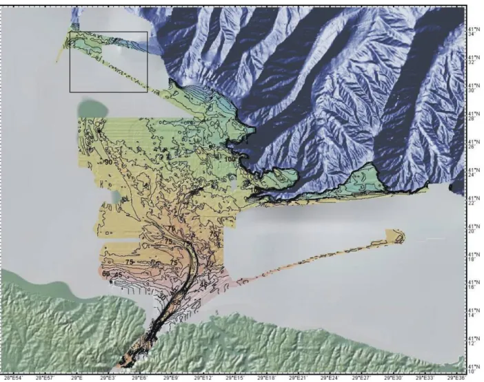
The morphology of the İstanbul strait outlet shelf area was derived from data acquired in the frame of NATO Project (Di Iorio & Yüce 1999). These data, in conjunction with dating and very high resolution seismic (Chirp) data were used to interpret shelf features.
Interpretation of the 3D multibem bathymetric map indicates that a prominent cut channel has a direct connection with the İstanbul Strait. This seafloor marked channel trends towards NE-SW and then turns NW to SE direction on the shelf area (Figure 1). Figures 2a and 2b present the 2D bathymetric and contour map of the area, together with the profile locations. Water depth is about 30m at the İstanbul Strait and between 30-45m where channel banks are prominent. Towards the middle shelf, water depth reaches 75m on both sides of the channel. The distal part of the channel system abruptly turns towards the northwest when reaching the mid-shelf. Figure 2b presents this channel system on the combined multibeam echosounder map of the bathymetric data acquired on the proximal shelf by the NATO project, with the Ifremer data collected during the BlaSON2 project at the shelf edge down to the slope toe.
This channel system consists of 1 main and 6 secondary channel. Some of the secondary channels are divided into distributaries. The main channel is directly connected to the İstanbul strait and is well defined in the bathymetry. This NE trending channel abruptly makes a 90° turn and trend towards NW (around latitude ~ 41º20´N). In addition to the main channel six other secondary channels can be followed. The depth of the main channel is min 30m and max 50m. Its width is 800m.
Two other distinctive sedimentary features have been recognised on the shelf area (Figure 3). The first features, which are characterised by their shape and trend, are interpreted as ridges. These ridges are also classified into two types:
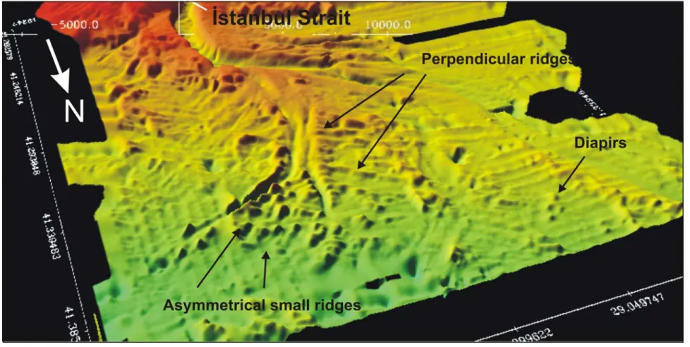
(1) First types, which are ridges perpendicular to the channel axis, are randomly distributed and exists at the distal part of channels 1 and 2. The heights of these perpendicular ridges vary between 1 to 7m. The ridges morphology and stratigraphy indicate that they have settled after the formation of the channel levees.
(2) Second types, are present at the distal part of the fan system itself and are asymmetrical ridges. Their heights vary between 1 to 5m, and never exceed 10m. The distances between them vary between 200-1000 m and they have been recognised within small groups or arranged into lines (Figure 3). These asymmetrical ridges correspond to diapir-like bodies settling around the channel system. They are generally located away from the system, have circular shapes and are randomly distributed.
3.2. Seismic interpretation of the structures on the shelf area. 3.2.1. Channel-levee system
Many channels are visible on the bathymetric map (channels 1-6, Figure 3; channels 1-2 in Figure 4a).Younger and incisive (sharp) channels are visible on channel banks. In Figure 4a, the profile P24 is crossing these two types of channels. On the seismic section two erosional surfaces are recognised. They correspond to the erosional surfaces named α and α1 by
Hiscott et al. (2002). The thin unit between the erosional surfaces α and α1 is named Unit 1B.
This last erosional surface α1 and Unit 1B disappear at the bottom of the channels.
The fact that these channels are empty might indicate that they are still active or there is not enough sediment supply to have sedimentary deposit in these channels. The channels also present a meandering pattern. The sides of the channels are constituted of levees corresponding to period of overbanking.
3.2.2. Ridges
At its southwestern part, profile 24 crosses ridges that are lying on channel 1 and 2 (Figure 4a). Profile is passing through the western ridges which are shown on the multibeam echosounder map (Figure 3), and which are perpendicular ridges to the main channel of the system.
The top part of these ridges is veneered by recent (Holocene) sediments. These ridges rest on erosional surface α1 and were defined as barrier bars by Aksu et al. (2002a). These
features have a characteristic inner structure. They have a gentle slope on stoss side and a steeper slope on lee side. On profiles they are about 7-20m in height and 200-300m in width. There is approximately 1 km between each ridge. Towards the shelf edge these ridges become smaller (3-5m) in height and are only a few tens meters in width. However, this increase could be related to the increase in flux (flow rate) towards shelf edge. Figure 4b shows part of profile 36 that crosses some of the ridges that are seen on the levees. These are very small and are located more closely spaced compared to the ridges on shelf part (parallel ridges to the main channel). P36 trends almost parallel to channel 1 with a high angle (~20° to normal), so we could in order see the levees longitudinally cut. The inner
structures of ridge features are chaotic with high reflectivity. This causes acoustic masking of the underlying sediments.
3.3. Seismic stratigraphy of the channel system
The internal structure of the subaqueous fan is studied using chirp seismic profiles. The seismic stratigraphy is here based on the nomenclature of Aksu et al. 2002a. Chirp profile 22, presented in Figure 5a, displays the stratigraphy used in this study in correlation with Aksu’s nomenclature. Four different units and two different unconformities have been recognised. Unit 3, corresponding to the basement, is marked by acoustically strong internal reflections including folded and faulted strata. The two erosional surfaces interpreted on the chirp profile correspond to α and α1 (Aksu et al. 2002a), with α1 is representing the erosional
surface separating Unit 1B from Unit 1.
Unit 2 presents a set of north dipping reflectors, indicating a progressive sea level fall (regression) and is interpreted as the Cretaceous limestone formation, intercalated with volcano sedimentary formation (Aksu et al. 2002a). This Unit is made of seaward dipping strata truncated at the shelf edge by the unconformity surface α. This α unconformity was formed during a low stand erosional phase. Erosional unconformity surfaces were also observed across the whole south-western Black Sea shelf by Aksu et al. (2002a), who argued that it was formed during the last glacial maximum low stand.
In contrast Unit 1B is consists of cobble sand and shell of brackish molluscs (Figure 5b) (William Bill Ryan, pers. comm. 2008, 2009). This unit is not present over the whole studied area. Unconformity surfaces α and α1 merge in some places to form a unique horizon where
Unit 1 is absent. In this section, Unit 1 overlies a craggy unconformity α (Figure 5b). To the norther, Unit 1B is encountered and lies on the unconformity α. It has a chaotic structure and the limits of the sequence are not clearly defined.
Isopach maps of Unit 1B and Unit 1 are presented in Figure 6. Interpolation was needed to fill the gaps where chirp data are missing. The isopach map of Unit1B does not match the structure of the channel system. Therefore, the existence of Unit1B could be explained with deposition before the fan formed. There is a second erosional surface α1 formed due to a sea
level fall. This erosional surface truncated most of Unit 1B. 14C age measurements yield and uncorrected age for this erosional surface of ~10750y BP (William Bill Ryan, pers. comm. 2008, 2009). In contrast, sediment thickness map of Unit 1 is compatible with the structure of the channel system (Figure 6b), indicating that Unit 1 settled during the formation of the channel system.
3.3.1. Lowstand wedge
A prograding wedge is recognised at the shelf edge of the studied area. It rests over the α unconformity and gives information about the level of the correlative low sea level (Figure 7). The wedge stands over the underlying clinoforms (above α) and is truncated by α1, indicating
a second sea level drop (last low stand). These wedges were widely studied by Algan et al. (2002). Their architecture correlates with our data.
The depth of sea level during last Glacial Maximum was calculated from the base of this wedge giving a water level at the shelf edge around -110 m for the Last Glacial Maximum (LGM). Demirbağ et al. (1999) obtained a depth of -105 m for the LGM. Recent research by Ryan; and collaborators reveals ~11800y BP 14C uncalibrated age (William Bill Ryan, pers. comm. 2008, 2009) for Unit 1B.
3.4. Dating of the subaqueous shelf fan
Foraminiferal assemblages compositions were analysed from core B2KS02 at the Department of Marine Sciences, Università Politecnica delle Marche (Giunta et al. 2007). Samples were dried (40°C degree) and weighted, washed with running water and sieved (63 micron), and dried again at the same temperature. The residues (> 63 micron) were split (with a microsplitter) the number of times necessary to obtain an aliquot fraction of about 200 specimens of foraminifera, which were counted and identified. All the benthic foraminifera were picked and mounted in slides to provide a collection of the benthic assemblages. The collection is available at the Department of Marine Sciences, Università Politecnica delle Marche. During the analysis of the foraminifera assemblages, all the bivalves, gastropods and ostracods were also counted. From the census counts, percentages were calculated together with benthic and planktonic foraminifera, bivalves, ostracods per gram of dry sediment, number of species of benthic foraminifera, and % of water content.
In core B2KS02, 26 samples for isotopic analysis were prepared. On average, 15 specimens of Ammonia beccarii were picked from the 150-micron size fraction, this species was chosen because of its continuous presence along the investigated core. Five 14C AMS(accelerator mass spectrometry) dates are available for this core (Table 2).
Benthic foraminifera in core B2KS02 are present throughout the core (Figure 8). In Unit I-B and II-B benthic assemblages are characterised by a low number and a low diversity of specimens. In the transitional phase (upper part of Unit III-B) the benthic assemblage is dominated by Ammonia genera, which is in great abundance in the bottom part of the core. The presence of benthic foraminifera in the entire core testified that ecological condition was ideal for the development of benthic microfauna since 6700y 14C BP. The site recorded the entrance of salt water (bottom of the core) and strong increasing in the sedimentation rate, that ends with the beginning of the normal sedimentation (Unit II-B).
Shelf cores testified to regional response of the platform during the Holocene evolution of the Black Sea. In the north western part of the Black Sea, benthic foraminifera colonised the sea bottom after that the sapropel deposition already started in the basin. In the western part of the shelf (core B2KS02), the microfauna colonised this part of the Black Sea shelf as soon as the connection with the Marmara Sea was re-established.
4. Discussion and conclusions
This study presents new results obtained on the subaqueous fan located at the shelf of Black Sea outlet of the Bosporus (Di Iorio & Yüce 1999; Flood et al. 2009). The shelf fan is formed of 1 main channel and 6 tributary channels, which are present on the shelf area at the Black Sea exit of the İstanbul Strait (Figure 9). These secondary channels change directions while they avulse. The 1st ,2nd, 3rd and 4th generations of tributary channels are fossils, while the 5th and 6th channels are still actively connected to the main channel. In Figure 9,on the 2D multibeam map, we see the continuation of channel 6. The continuations of the channels are in the direction as indicated by Flood et al. (2009). A modern channel is evident on the chirp profile 53 (Figure 10). Furthermore, there is a wide older channel underlying the modern one. This probably indicates that, before the modern channel there was another channel in the same direction during low stand. This may indicate that the system is reworking. However one one chirp profile is available for this region, and more profiles are required to test this hypotheses.
In this study, 3 different units and 2 erosional surfaces were observed. The main erosional surface, named as α (Aksu et al. 2002a; Aksu et al. 2002b) delineates Unit 1B which is directly deposited on this erosional surface α eroded by some channels. Unconformity α
truncates the entire south-western Black Sea shelf. Within Unit 2, north dipping reflectors have been interpreted as being related to a sea level drop. This α unconformity is the erosional surface resulted from this sea level drop. Unit 1 rests on all units at the shelf area and has been divided into 4 subunits by Aksu et al. (2002a). These 4 subunits were characterised from their geometry and seismic facies’ and interpreted as barrier islands linked to sediment waves and current forming these marine bars. Aksu et al. (2002a) suggested that these features are transgressive features formed by relatively rapid sea level rise. Similar bodies have been observed on the Ukranian and Romanian shelves, where they were interpreted as beaches, sand dunes and coastal features surrounding the Black Sea shrunk lake before the flood (Ryan et al. 2003; Lericolais et al. 2003).
Unit 1 is interpreted as the unit that was settled during the formation of channel system. Unit 1 is located in the core of the fan, and comprises of grey to green mud. It yield an uncorrected 14C age of 6700y BP (Giunta et al. 2007). Unit 1B is present from the inner to the outer shelf, while Unit 1 forms the upper unit of the fan system. Therefore, Unit 1B has different age and formation conditions than Unit 1, and cannot be considered a subunit of Unit 1. The craggy surface of α indicates that, a huge amount of water carrying grained material entered to the Black Sea.
The features that are interpreted as ridge-style features, are increasing in number towards the shelf edge. That is probably related to the increase of the current velocity at the shelf edge. While the current velocity is 70 cm.s-1 at the exit of the İstanbul strait, it reaches 90 cm.s-1 at the shelf edge (Özsoy et al. 1995). The current velocity map published by Ozsoy et
al. (2001) shows that the direction of the channels are compatible with the directions of
currents at the Black Sea exit of the İstanbul strait. Accordingly, the distribution of the directions of the channel system is directly related with the current entering the Black Sea from the Marmara Sea. Also, on recent bathymetric maps published by Flood et al. (2009), it is clear that some of the levees are affected by outgoing active currents issued from the Bosporus. This could only happen in a hydrodynamic background which is today still rather active.
Mounds recognised in this study present acoustic masking or chaotic infilling. Masking might be related to high reflectivity. Equivalent mounds were interpreted as mud volcanoes by Aksu
et al. (2002a). The core B2KS02 was recovered from such a mound having a weak acoustic
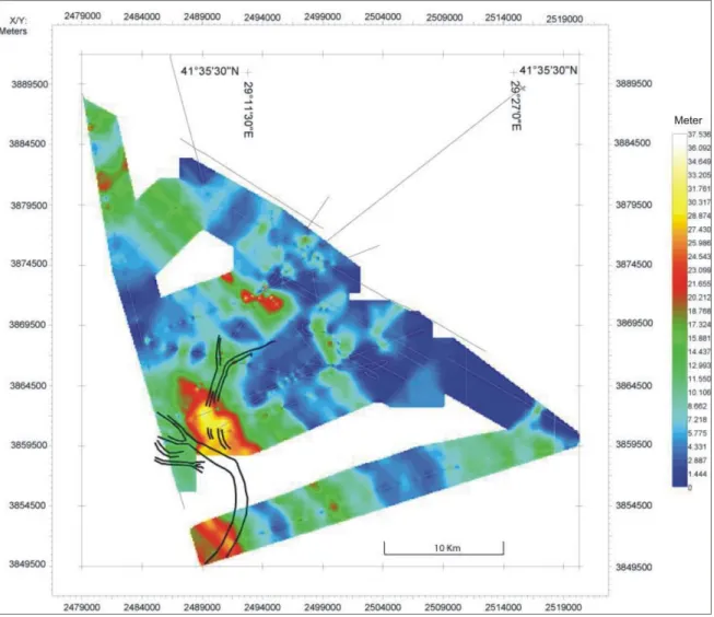
masking. No gas indication was observed in the core sediments. Therefore, according to our data, these kinds of structures which are present on the middle shelf area can not be interpreted as mud volcanoes. However, we observed other mud volcano resembling structures on other profiles which are not shown in the given study area (Okay et al. 2006). The box on the bathymetric map in Figure 2a, shows the location of mud volcano resembling structures.
The core B2KS02 has dated the base of Unit 1 at 6700 y 14C BP, allowing us to estimate that water input was synchronous with the onset of Unit1. Besides the dating of the fan, the core supplied a major information vital to the understanding of the formation of the fan. The strong concentration of benthic foraminifera at the base of this unit indicates that Mediterranean water brought these elements while penetrating into the Black Sea. This hypothesis questions the previous theories which support a reconnection without high energy and a rapid equilibrium between the two way currents. In the present two way flow regime, benthic foraminifera are rare in the Black Sea. The drop in concentration of the benthic foraminifera around 4 meter deep in the BSKS02 core of Unit 1, is interpreted to be linked to a drop in salinity after the reconnection as the two water bodies entered into equilibrium (two way flow).
The observed wedge at the shelf edge is thought to be formed during the sea level drop when α was formed (Figure 7). The wedge contains downlapping clinoforms and the top of
the prograding horizon is truncated by α1 surface, indicating that this region was exposed to
a sea level drop immediately after a sea level rise.
Except from these structures, some paleo canyon heads were also observed near the shelf edge area. The preservation of these canyon heads, also led us to assume a rapid increase in Black Sea level. In case of slow increase, these structures should have been eroded by the strength of ravinement.
High resolution chirp data in addition with dating show that, after the last low stand the south-western Black Sea shelf was drowned by Mediteranean waters. Figure 11 outlines a likely scenario to describe the reconnection between the Black and Marmara Seas since last glacial maximum. A low stand systems tract was set at -110 m, with a first erosion surface α on the shelf during the glacial maximum (Stage B). After the LGM (Stage B) ice began to melt around 18 000y BP and flow of big rivers; Dniepr, Dniestr, Bug and Volga increased. Also, melted ice from the Alps fed the Danube. Such phenomena were accelerated after the melt water pulse 1 MWP1 (14 500 Cal yrs BP or 12 500y 14CBP). This transgression raised the level of the Black Sea (Black Sea basin was a closed basin at that moment) by 80 m until reaching the -30/-40 m isobaths. It’s not obvious whether the sea level of Black Sea reached to a level which is higher than the Bosporus sill and whether fresh water of the Black Sea passed into the Marmara Sea but some clues such as studies on fauna seem to agree with this hypothesis and are coherent with recent publications about Marmara Sea studies (Eris et
al. 2007). Unit 1B was deposited during high stand period.
After the melting stage, (Stage C) Black Sea level began to decrease and a second low stand systems tract between -80m and -100m led to a second erosion surface α1 on the
shelf. Evidence of this decrease includes dated Unit 1B (William Bill Ryan, pers. comm. 2008, 2009). This unit is not existent on everywhere on the shelf, a big erosive phase probably truncated most of the unit. The age of this low level from this analysis is between 11 410y 14C BP and 10 640y 14C BP (uncorrected ages).
Finally, based on the age data from the dating of core B2KS02 we can affirm that Black Sea received salty water from the global ocean at 6700y 14C BP. It is not clear whether this event happened catastrophically, but the two way connection previously proposed by anti-catastrophes cannot explain how that such amount of material have been moved to form such a big shallow fan.
For Stage D, studies show that around 6700 yr C14 BPtheBlack Sea received a big amount of salty water, most likely associated with high energy. In addition, we propose that the Unit 1 sediments came from eroded material of the Bosporus strait. It is difficult to imagine the influx of such volumes of sediments provided in a short period of time without a strong reconnection. If, as clearly shown by this study, there was a major transgression of the Black Sea 6700 y 14C BP, this last increase of water was not catastrophic. In particular, more detailed data from the area between the İstanbul Strait and the fan would allow us, how the fan material has been provided to the shelf.
5. Acknowledgements
The research was supported by the French ministry of foreign affairs within the frame of a bi-lateral collaboration between France and Romania, and prolonged by a European project of the 5th framework program called ASSEMBLAGE (EVK3-CT-2002-00090). This study is part of Okay’s PhD thesis defended at Dokuz Eylül University and supported by the Scientific and
Research Council of Turkey (TUBITAK) grant (Project Code: 102Y112) and by a Dokuz Eylül University Research Foundation grant (Project Code: 2005.KB.FEN.034).
We are thankful to Eliane Le Derezen for Multibeam processing and Tuncay Taymaz for his review. Discussions with Ali E.Aksu and Oya Algan have contributed to our understanding. Also we’re grateful to William.B.Ryan for helpful discussions during Okay’s stay in Lamont Doherty Earth Observatory from March to June 2009. And special thanks to the crew of the vessels "Le Suroit" (Ifremer) and "Marion Dufresne" (IPEV).
6. References
AKSU, A.E., HISCOTT, R.N. & YAŞAR, D. 1999. Oscillating Quaternary water levels of the Marmara Sea and vigorous outflow into the Aegean Sea from the Marmara Sea Black Sea drainage corridor. Marine Geology 153, 275-302.
AKSU,A.E.,HISCOTT,R.N.,MUDIE,P.J.&ROCHON, M.A., 2002a. Persistent Holocene outflow from the Black Sea to the eastern Mediterranean contradicts Noah's Flood hypothesis. GSA Today 12(5), 4-10.
AKSU,A.E.,HISCOTT,R.N., YASAR,D.,İSLER,F.I.,&MARSH,S. 2002b. Seismic stratigraphy of Late Quaternary deposits from the southwestern Black Sea shelf: evidence for non-catastrophic variations in sea-level during the last ~10000 yr. Marine Geology 190, 61-94.
AKSU, A.E., HISCOTT, R.N., KAMINSKI, M.A., MUDIE, P.J., GILLESPIE, H., ABRAJANOD, T., & YASAR, D. 2002c. Last glacial-Holocene paleoceanography of the Black Sea and Marmara Sea: stable isotopic, foraminiferal and coccolith evidence. Marine Geology 190, 119-149.
ALGAN, O., GÖKAŞAN, E., GAZIOĞLU, C., YÜCEL, Z., ALPAR, B., GÜNEYSU, C., KIRCI, E., DEMIREL,S.,SARI,E.&ONGAN,D. 2002. A high-resolution seismic study in Sakarya Delta and Submarine Canyon, southern Black Sea shelf. Continental Shelf Research 22, 1511–1527.
ARSLANOV,K.H.A.,GEI,N.A.,IZMAILOV,Y.A.A, LOKSHIN,N.V.,S.A.GERASIMOVA,S.A.&N.I.
TERTYCHNY 1983. O vozraste i klimaticheskikh usloviakh formirovania osadkov
ozdnepleisotsenovikh morskikh terras poberez’ia Kercheskogo proliva [On the age and climatic conditions of sediment formation in the Late Pleistocene marine terraces of the Kerch Strait]. Vestnik Leningradskogo Gosudarstvennogo
Universiteta (LGU), seriia geologiia-geografiia 12, 69–79.
BAHR, A., ARZ, H.W., LAMY, F. & WEFER, G. 2006. Late glacial to Holocene paleoenvironmental evolution of the Black Sea, reconstructed with stable oxygen isotope records obtained on ostracod shells. Earth and Planetary Science Letters 241, 863-875.
BAHR, A., LAMY, F., ARZ, H.W., MAJOR, C., KWIECIEN, O. & WEFER, G. (2008): Abrupt changes of temperature and water chemistry in the late Pleistocene and early Holocene Black Sea, Geophysical Journal International 169, 29-40.
BALABANOV,I.P.2007. Holocene sea-level changes of the Black Sea. In: Yanko-Hombach, V., Gilbert,A.S., N. Panin, N. & Dolukhanov, P.M.(Editors), The Black Sea Flood Question: Changes in Coastline, Climate, and Human Settlement. Springer, New-York (USA), 603-631.
BALANDIN, YU.G. & TRASHCHUK, N.N. 1982. Kolebaniia urovnia moria v golotsene i ikh otrazhenie v stroenii litifitsirovannykh rakushechnykh otlozhenii Arabatskoi kosy Azovskogo moria [Sea-level changes in the Holocene and their reflection in the structure of lithified coquina sediments of the Arabatkaia spit on the Sea of Azov]. In
Izmeneniia urovnia moria [Sea Level Fluctuations], P.A. Kaplin, ed., 227-237.
DEMIRBAG,E., GÖKASAN, E., OKTAY, F.Y., ŞIMSEK, M. & YÜCE, H. 1999. The last sea level changes in the Black Sea: evidence from the seismic data. Marine Geology 157, 249-265.
DI IORIO, D. & YÜCE H. 1999. Observations of Mediterranean flow into the Black Sea.
Journal of Geophysical Research 104C, 3091-3108.
ERIS,K., RYAN,W.B.,CAGATAY,M.N., SANCAR,U.G., LERICOLAIS,G., MENOTG. &BARD,E. 2007. The timing and evolution of the post-glacial transgression across the Sea of Marmara shelf south of İstanbul. Marine Geology 243, 57-76.
FEDOROV, P.V. 1988. The problem of changes in the level of the Black Sea during the Pleistocene. International Geology Review 30, 635-641.
FLOOD, R.D., HISCOTT, R.N. & AKSU, A.E. 2009. Morphology and evolution of an anastomosed channel network where saline underflow enters the Black Sea.
Sedimentology 56, 807-839.
FONTUGNE, M., GUICHARD, F., STRECHIE, C. & LERICOLAIS, G. 2009, Reservoir age of the
Black Sea waters during anoxic periods. Radiocarbon 51.
GIOSAN,L., YANKO-HOMBACH,V., GILBERT,A.S.,PANIN,N. &. DOLUKHANOV P.M., 2007. In:
The Black Sea Flood Question: Changes in Coastline, Climate and Human Settlement, Springer, Berlin, Quaternary Science Reviews 26, 1897-1900.
GIUNTA, S., MORIGI, C., NEGRI, A., GUICHARD, F. & LERICOLAIS, G. 2007. Holocene biostratigraphy and paleoenvironmental changes in the Black Sea based on calcareous nannoplankton. Marine Micropaleontology 63, 91-110.
GUICHARD,F.&ASSEMBLAGE PARTNERS.2006. Assemblage deliverable 14: Isotope curves; tables of absolute ages obtained from on dating of sample, European Community,
Energy, Environment and Sustainable Development, Brest.
HISCOTT,R.N. &AKSU,A.E. 2002. Late Quaternary history of the Marmara Sea and Black Sea from high-resolution seismic and gravity-core studies. Marine Geology 190, 261-282.
HISCOTT, R.N., AKSU, A.E., YASAR, D., KAMINSKI, M.A., MUDIE, P.J., KOSTYLEV, V.E., MACDONALD,J.C.,ISLER,F.I.&LORD,A.R.2002. Deltas south of the Bosporus Strait record persistent Black Sea outflow to the Marmara Sea since ~10 ka. Marine
Geology 190, 95-118.
HISCOTT,R.N.,AKSU,A.E.,MUDIE,P.J.,MARRET,F.,ABRAJANO,T., KAMINSKI,M.A., EVANS, J., ÇAKIROGLU,A.İ. &YASAR,D.2007. A gradual drowning of the southwestern Black Sea shelf: Evidence for a progressive rather than abrupt Holocene reconnection with the eastern Mediterranean Sea through the Marmara Sea Gateway. Quaternary
International 167-168, 19-34.
KWIECIEN, O., ARZ, H.W., LAMY, F., BAHR, A., WULF, S. & HAUG, G.H. 2006. Preliminary results on core MD04 2760 from the southwestern Black Sea. European
Geosciences Union 2006, Geophysical Research Abstracts, Wien, Vol. 8, p. 06947.
LERICOLAIS, G., LE DREZEN, E., NOUZÉ, H., GILLET, H., ERGUN, M., CIFCI, G., AVCI, M., DONDURUR, D. & OKAY, S.2002, Recent canyon heads evidenced at the Bosporus outlet. American Geophysical Union. (AGU Fall Meeting), San Francisco, California, Abstracts, EOS, Transactions, p. 83 (47).
LERICOLAIS, G., POPESCU, I., PANIN, N., RYAN, W.B.F. & GUICHARD, F. 2003. Last Rapid Flooding in the Black-sea. In: S. Uscinowicz and J. Zachowicz (Editors), Rapid
transgressions into semi-enclosed basins - IGCP 464. Polish Geological Institute,
Gdansk, p. 39.
LERICOLAIS,G.,POPESCU,I.,GUICHARD,F.&POPESCU,S.M.2007. A Black Sea lowstand at 8500 yr B.P. indicated by a relict coastal dune system at a depth of 90 m below sea level. In: J. Harff, W.W. Hay and D.M. Tetzlaff (Editors), Coastline Changes:
Interrelation of Climate and Geological Processes. GSA Books; Allen Press, Inc.,
OKAY,S.,ÇIFCI,G.,LERICOLAIS,G.,BOHRMANN,G. AND IVANOV,M., 2006. A tributary canyon system, shallow gas accumulations and an unnamed mud volcano at Bosphorus outlet in Black Sea. European Geosciences Union, Geophysical Research Abstracts 8, 8072,Wien.
OZSOY,E.1995. "Exchanges with the Mediterranean, fluxes and boundary mixing processes in the Black sea." Bulletin de l'Institut Océanographique Monaco no spécial 15, 1-25. OZSOY,E.,DI IORIO,D.,GREGG,M.&BACKHAUS,J.2001. “Mixing in the Bosporus Strait and
the Black Sea continental shelf: observations and a model of the dense water outflow” Journal of Marine Systems 31, 99-135.
RYAN, W.B.F., PITMAN, W.C., MAJOR, C.O., SHIMKUS, K., MOSKALENKO, V., JONES, G.A., DIMITRO, P., GÖRÜR, N., SAKINÇ, M., & YÜCE, H. 1997. An abrupt drowning of the Black Sea shelf. Marine Geology 138, 119-126.
RYAN,W.B.F.,MAJOR,C.O., LERICOLAIS,G.,&GOLDSTEIN,S.L. 2003. Catastrophic flooding of the Black Sea. Annual Review Earth and Planetary Sciences 31, 525-554.
SVITOCH, A.A., SELIVANOV, A.O. & YANINA, T.A. 2000. Paleohydrology of the Black Sea
Pleistocene Basins (Translated from Vodnye Resursy, Vol. 27, No. 6, 2000, pp. 655– 664. Original Russian Text Copyright © 2000 by Svitoch, Selivanov, Yanina). Water
Resources 27, 594–603.
YANKO, V. 1990. Stratigraphy and paleogeography of marine Pleistocene and Holocene deposits of the southern seas of the USSR. Memorie della Società Geologica
Italiana 44, 167-187.
YANKO-HOMBACH,V.,BALABANOV,I.,MITROPOLSKY,A.&GLEBOV,A.2002. Late Pleistocene-Holocene history of the Black Sea: Is there any room for the Ryan-Pitman Hypothesis “Noah’s Flood.” Third International Congress on Environmental
Micropaleontology, Microbiology and Meiobenthology, Vienna, Program and Abstracts, p. 203-206.
YANKO-HOMBACH, V., GILBERT, A.S.,PANIN, N. & DOLUKHANOV, P.M.2007. The Black Sea
Flood Question. Changes in Coastline, Climate and Human Settlement. Springer,
7. Figures
Figure 1. Multibeam bathymetry map of the study area. Multibeam bathymetry acquired during Blason2 survey is combined with existing bathymetry of Di Iorio and Yuce (1995)
Figure 2. (a)Bathymetric contour map of the study area. The marked black box shows only the location of mud volcano resembling structures area.
Figure 2. (b)2D multibeam bathymetry map of the shelf fan. Solid lines illustrate the high resolution seismic (chirp) profiles of the shelf fan area and numbers belong to the channel numbers. The star icon shows the location of the core which is used for dating.
Figure 3. Visualization of ridges on the multibeam bathymetry map showing perpendicular ridges to the channels of the fan and asymmetric ridges at the distal part.
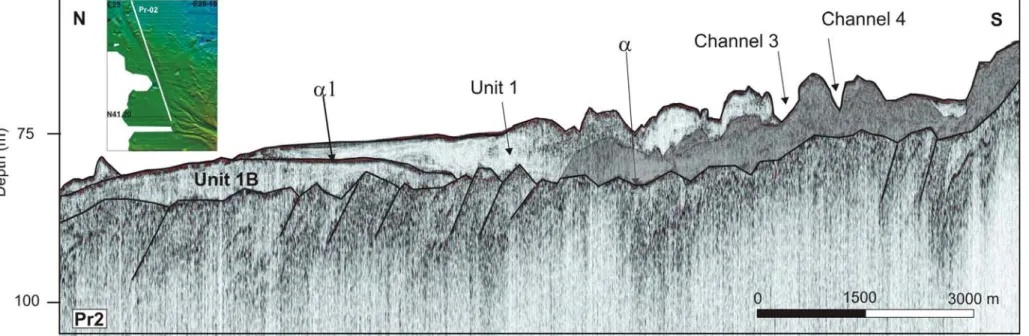
Figure 4. (b) Shelf part of profile Pr-36 which cuts the whole study area in SW-NE direction, crossing channel 1. Ridges are situated on the levees of the channel.
Figure 5. (a) Seismic structure model of the shelf fan, on a profile cutting the fan in SW-NE direction. Four different units are interpreted. Unit 3 is the basement unit, Unit 2 consists of seaward prograding reflectors and it toplaps to upper unit, Unit 1 B has a chaotic structure and Unit 1 which is deposited during the formation of the fan. α and α1 are different unconformity surfaces.
Figure 9. Drawing of the shelf fan’s channels. Numbers show the channel numbers in the order of activity. Now Mediterranean flow is active in channels 5 and 6.
Figure 11. Schematic representation of the stages of the connection between Black Sea and Marmara Sea since Last Glacial Maximum.
8. Tables
Table 1. Location and parameters of core B2KS02 used in this study
Core B2KS02 Type Kullenberg Cruise BLASON2 Latitude 41°29.734 Longitude 29°07.550 Water depth(m) 88.8 Sediment recovery 9.07 Studied core length(cm) 907
Table 2. Sample type for 14C AMS dating in core B2 KS02
ID number Core depth cm Sample type weight (gr)
1 B2KS 02 80-81 Bivalves 0.07
2 B2KS 02 350-351 Bivalves 0.16
3 B2KS 02 875-876 Hydrobia 0.16
4 B2KS 02 875-876 Ammonia beccarii 0.05