HAL Id: hal-02043127
https://hal.archives-ouvertes.fr/hal-02043127
Submitted on 20 Feb 2019HAL is a multi-disciplinary open access archive for the deposit and dissemination of sci-entific research documents, whether they are pub-lished or not. The documents may come from teaching and research institutions in France or abroad, or from public or private research centers.
L’archive ouverte pluridisciplinaire HAL, est destinée au dépôt et à la diffusion de documents scientifiques de niveau recherche, publiés ou non, émanant des établissements d’enseignement et de recherche français ou étrangers, des laboratoires publics ou privés.
Archaeology, environment, and socio-cultural change
Isaya Onjala
To cite this version:
Isaya Onjala. Southwestern Kenya during the second millennium AD: Archaeology, environment, and socio-cultural change. Les cahiers d’Afrique de l’Est, IFRA Nairobi, In press, La diffusion des plantes américaines dans la région des Grands Lacs. Approches générale et sous-régionale, l’Ouest kényan. Dissemination of the American Plants in the Great Lakes Region. General and Sub-Regional Approaches, the Western Kenya, pp.109-126. �hal-02043127�
Archaeology, environment, and socio-cultural change
Isaya O. Onjala
Many archaeological sites, particularly the stone structures in the southwestern Kenya Region, have not been fully studied to realize a complete understanding of the archaeology and history of the region. This paper gives a brief narrative of the second millennium interactions between environment and people who moved into this region and the creation of later archaeological and agricultural landscapes. In this brief write up, however, there are more questions than answers. There is, therefore, need for a coordinated excavation at different sites within the region to provide data that may be useful in developing comparisons across sites, and, allowing for general accurate conclusions and inferences to be made about the archaeology and history of the region. A detailed spatial analysis of the structures, using modern methodologies, is also likely to help build an understanding of human-environment interaction and the proper setting of the sites wherever they are located within the region. The nature of social organizations and power structures associated with the fortified sites, and an in-depth analysis of cultural materials, especially, excavated artefacts, will also be necessary so as to reconcile information from oral literature with that from the archaeological record. Other concerns include the establishment of reliable dates for the sites and tackling the question of economic activities, such as, agriculture, trade and environmental exploitation activities of economic nature. Lastly, population movement in the area, which is so dominant in the oral tradition, has been discussed but requires further investigation to understand population interaction and flow into other areas, particularly, northern Tanzania as contained in the oral tradition.
Introduction
The archaeology, environment, and the socio-cultural change of the southwestern Kenya region expose the intricate archaeology of a region where archaeological remains and/ or sites may not explicitly reflect environmental and socio-cultural changes in space and time. This is because, more often than not, the sites, especially the stone structures whose history dominate the second millennium AD within the region, provide little or no direct evidences for environmental and socio-cultural changes. The rise of complex settlements, interactions within the ecological zones, and the general environmental changes that were witnessed can, therefore, only be deduced from proxy data derived from other studies. Further, other social-cultural changes including later population movements across and outside the region and the establishment of economic activities, such as agriculture and extensive trade that thrived until the coming of the colonial authorities all remain areas with little information or data that can help us understand what was taking place within the region during the second millennium AD.
While more questions remain unanswered, data from archaeology, oral traditions, historical linguistics, and ecological history provides us with information that allows for
some arguments, towards the presence and evolution of complex systems that resulted into the establishment of large settlements that dominate the archaeological landscape, as well as the presence of socio-cultural, economic, and political activities that became the driving force for changes realized during the second millennium AD within the southwestern Kenya region.
Lake Victoria Basin during the second millennium AD
The Second millennium AD contains important archaeological, environmental and social-cultural records useful in understanding past developments in the southwestern Kenya and northern Tanzania. Before focusing on this important area of study, however, a discussion on the entire Lake Victoria Basin is necessary in order to give a general perspective on factors that influenced changes in southwestern Kenya. Globally, the period marked an increase in human population, which sparked off diverse human activities that had considerable social and environmental consequences (Lleju 2012). According to Schmidt (1997) the Great Lakes Region witnessed marked levels of population movement occasioned by population pressures in settled areas. For example, iron producing groups that had settled in Buhaya (in the present day Uganda) and in Rwanda had great impact on the environment by increasing the amount of iron produced through the exploitation of forest resources along the once resource-rich Lake Victoria shoreline between AD 300 and AD 500. By AD 600, however, iron production had declined in the region, forcing communities to move further north to settle in more open woodland and grassland environments where they took to pastoralism as a major economic activity and later establishing permanent settlements (Schmidt 1997). Such movements may have been triggered by scarcity of resources and, therefore, the need to move out in search of new ones.
Archaeological and linguistic evidence from the Lake Victoria Region suggests that the period saw the formation of major settlements of farming communities in the lakeshore line, which later expanded to occupy more interior areas (Sutton 1993). In such areas, archaeological records and historical linguistics suggest major population increases putting a high demand on forest resources for both agriculture and iron smelting activities. The people involved were mainly Bantu speaking communities who had experienced a rapid socio-cultural change resulting into increased wealth and demand for more resources to cater for their agricultural and iron smelting needs during the first millennium AD extending into the early parts of the second millennium AD when Later Iron Age Cultures developed.
These changes coincided with a significant decline in the catchment forest vegetation of Lake Victoria starting around AD 975 and continuing to about AD 1155 (Lejju 2012). Fossil sediment records, as well as pollen records, indicate activities such as cultivation, burning and livestock keeping with proxies, such as pollen, phytoliths, starch and fungal spores documenting vegetation composition, and anthropogenic conditions or activities that point towards a decline in the catchment forest vegetation, mostly for settlement and agricultural activities along the lake shoreline (Lejju 2005 & 2012; Lejju et al. 2006). Such sharp decline in forest cover within the region could have resulted in increased demand for food and iron production with populations moving to new areas. There was, for example, movement of communities to central plateau of northern Tanzania to exploit the forest resources along the shoreline (Lejju 2012: vi). But such populations further
spread to other parts of the region causing conflicts and tension while interacting with other groups.
While there is evidence for enhanced precipitation at the start of the millennium (AD 1100 to 1200) from the Nile River levels and decreased salinity in the Lake Victoria basin, later periods registered prolonged droughts that caused famine in the region and may have resulted into large-scale migrations of groups of people up to around AD 1840. Examples of these famines include the Wamara famine (AD 1390–1420), the Nyarubanga famine (AD 1560–1625) and the Lapanarat-Mahlatule famine (AD 1760–1840), especially in Uganda (Webster 1979, Lejju 2012). At the time of these famines, there is a match with the decreased reconstructed sequence of Lake Victoria which also correlates with low lake levels within the Central Rift Valley lakes. This suggests widespread low precipitation in the East African region up to about the AD 1600 (Lejju 2005). The later part of the millennium (from about 1896 to 1961), however, registered increased precipitation with remarkable amounts of rain during the 1961 to 1964 period and in 1997 (Gelorini et al. 2013, Bessems et al 2008).
Archaeological and linguistic evidence further suggest that movement and settlement of different communities, particularly, the Bantu, Cushitic and Nilotic groups within the Lake Victoria region gave rise to distinct socio-economic conditions that characterized the region around the start of the second millennium AD (Reid 1990, Sutton 1993, Robertshaw 1997, Schmidt 1997), with major changes being witnessed in the socio-cultural and economic, as well as, political spheres.
One of the significant changes was the replacement of the Early Iron Age (5th century BC
to 6th century AD) with Later Iron Age. This change was marked by widespread change in
pottery styles with Later Iron Age pottery being dominated by use of roulettes to decorate pottery. However, limited work on Middle Iron Age Ceramics indicates some level of continuity in the use of previous ceramic styles (Ashley 2010). Generally, however, the archaeological record indicate changes with some of the sites indicating multiple cultural traditions, for example, Yala Bridge 1 recording changes from Later Stone Age (LSA) through Early Iron Age (EIA—Urewe) and Middle Iron Age (MIA) to scatters that indicate current Luo occupation in the area (Lane et al. 2006). The use of twisted or knotted roulette decorations became common in the later periods being identified from a number of archaeological sites both in central and southern Nyanza in western Kenya. For the later periods, however, Table 1 captures some of the sites, which require more work for the history of the region to be captured appropriately.
Apart from the changes reflected in the archaeological record, another development during this period was the construction of earthworks in what is today Uganda and Siaya in the northern Nyanza region. While the northern Nyanza region, especially the Siaya area, is dominated by Earthen bank-and-ditch Enclosures with a few dry stone enclosures, the southwestern Kenya region is dominated by dry stone architectural tradition resulting into numerous dry stone enclosures that spread southwards up to northern Tanzania. The North is dominated by earthen bank-and-ditch enclosures while the South is dominated by dry stone enclosures with a few earthen bank-and-ditch enclosures. This may imply that the technology required to construct both forms of enclosures was available in the two areas with a possibility of importation of the same from the Uganda side of Lake Victoria region since most of the groups moved through Uganda into Central Nyanza and eventually into southwestern part of Kenya.
Site Name Type of Site Cultural affiliation Area of location Oiko Earthworks Earthworks yet to
be archaeologically investigated
Iron Age and Luo Occupation
Bondo
Kipasi earthworks “ “ Bondo
Ajigo earthworks “ “ Bondo
Kibuye earthworks “ “ Bondo
Mitiro earthworks “ “ Bondo
Sigomre earthworks “ “ Bondo
Gangu earthworks “ “ Bondo
Got Abiero Stone structures “ Bondo
Got Rasoti Stone structures “ Bondo
Got Naya Modern (Luo) Luo Occupation Rarieda
Olango earthworks Earthworks yet to be archaeologically
investigated
Luo Occupation Rarieda
Gobei earthworks “ “ Rarieda
Sigono earthworks “ “ Rarieda
Raliew earthworks “ “ Rarieda
Mahaya earthworks “ “ Rarieda
Sangla earthworks “ “ Rarieda
Sige earthworks “ “ Rarieda
Lwak earthworks “ Urewe, MIA, Luo
Occupation (?)
Rarieda Thimlich Ohinga Stone structures and
excavated materials: roulette pottery; beads, and faunal
remaind
Luo Occupation (?) Nyatike
Other stone enclosures of South
Nyanza
Stone structures Luo Occupation (?) Nyatike
Table 1. Selected sites in the central and southern Nyanza regions
where more work will be required in order to understand the later prehistory of the region
The structures found in the southwestern Kenya region originate from a dry stone architecture tradition developed or utilized in the area during the later periods of settlement within the Lake Victoria Region. Locally known as the Ohingni, the monuments suggest the emergence of a more complex society where labour was highly organized to meet the demands for raw material sourcing and transport, control of the construction efforts
and activities involving architectural designs and space creation for different groups and activities within the settlements. The existence of simple and complex enclosures, as well as simple and multi-structured enclosures also point towards a hierarchical society where authority was held by some personality to whom allegiance was paid and instructions taken. Without such authority in the form of clan elders, a chief or a legendary/magical figure, the construction of complex sites like Thimlich Ohinga or Osani sites would not be easily realized (Onjala 1995). Such structures were usually created in the face of widespread population movements or migrations, search and struggle for new resources and adaptation within new environments around the lake where ecological changes were also taking place. Even though driven by necessity, the activities required and attracted leaders who provided leadership and ensured the desired goals were met marking the origins of social complexity in which different people did different things to have society forge ahead in development.
Oral tradition and early archaeological work associate the earthwork sites in Uganda with the Bachwezi whose Kingdom is believed to have had a long influence in the region. Bigo site, which is one of the best well-known Uganda Earthworks sites, together with other settlements, like Mubende Hills settlement, record evidence of cattle keeping and grain cultivation, activities that influenced and changed the economy of the entire Great Lakes region (Sutton 1993). The question of the earthworks and their link with the legendary Bachwezi Kingdom, however, has remained a topic of discussion among scholars who have raised different arguments for and against the link in attempts to understand the history of the region using oral history, archaeology and ethnology as different and complimenting sources of data or information (Schmidt 1990, Reid 2016, Robertshaw 2010, Robertshaw et al. 2000).
The immigrants into what is today North and Central Nyanza, as well as those that moved to southwestern Kenya and northern Tanzania, are believed to have passed through the area previously occupied by the Chwezi Kingdom in Uganda (Ogot 1967, Ochieng’ 1974, Ayot 1973). The movement from this area into the eastern part of the lake has created the impression that the skill for making earthworks and stone structures was learnt and used later on by the moving populations at different points of settlement, especially, in the Nyanza region.
Excavations done at Bigo, the site of the supposed Chwezi Kingdom and at a number of sites in the Nyanza region of Kenya, have been attempts to uncover the truth about the traditions and functions of the earthworks and ditches within the lake region, particularly the Uganda side and the traditions associated with the stone structures in the southwestern Kenya region (Sutton 1993, Wandibba 1986, Onjala et al. 1999). Little cultural materials, however, have been recovered from most of these sites, especially, from the stone structures of southwestern Kenya to help us understand the history of the dry stone structure tradition in the area.
While examining the stone structures in southwestern Kenya, particularly, the site of Thimlich Ohinga, Onjala (1995) used oral traditions to sketch the immigration routes (Figure 1) and also to identify Late Iron Age sites and historical sites. Most of these sites are located on hilly areas away from the more fertile margins of Lake Victoria where Early Iron Age sites were located during the first millennium to early second millennium AD. The sites exhibit hierarchies from simple to complex forms with characteristics of fortification that may indicate some form of social and ecological tension at the time of
their construction. Information obtained from most of the respondents during interview sessions indicate that the structures were fortifications for security reasons since many people were moving into the area and settlers were vulnerable to attacks by new comers. They were also used as land ownership markers and measures of protection against wild animals.
Figure 1. Migration routes used by early settlers in the southwestern Kenya region
Source: Onjala (1995).
Archaeology and history of settlement
When historians wrote the history of settlement in the southwestern Kenya (Ayot 1977 & 1981, Ochieng’ 1985) they avoided a discussion on the presence of stone built structures that are widely distributed in the region. This was probably due to the difficulty in ascertaining direct association between the settlers in the region and the settlements/ structures that they occupied. Most writers, however, think that there is need to research and establish the association that exists in order to better understand the changes that took place in the region.
Studies of early archaeological periods indicate that the region was occupied right from the Stone Age period when different bands of humans occupied different areas, leaving behind traces of their culture at different sites. Such areas include Kanam, Kanjira, Rusinga Island sites, Gogo Falls, and the many Later Iron Age sites preceded the many stone structure settlement sites distributed in the region (Figure 1).
During the second half of the second millennium AD, immigrants moved into the southwestern Kenya region in large numbers (Ogot 1967, Ayot 1977) probably due to the general factors, such as climatic influences, and socio-cultural and political developments that were taking place at the time and earlier within the Great Lakes region (Sutton 1993, Robertshaw 1997, Schmidt 1997). While there are detailed discussions on the Luo as to why, how and where they moved (Herring 1976, Wrigley 1981, Storch 2003), such discussions cover more of western part of the Lake and Central Nyanza and less of the southwestern Kenya region. Only oral history and limited historical records provide the process of migration into, and settlement of the region under discussion.
These immigrants into the region have been thought to be directly associated with or responsible for the construction of the stone structures, which is the main later period archaeological record found in the region. According to oral traditions (Onjala 1990, 1995), these monuments were made or constructed by the Bantu groups that first moved into this area. The Nilotic groups would then later come into the area and continue to use the structures therefore maintaining the tradition and making it to thrive. This, however, remains the bone of contention as the members of the latter group insist that they are, at least, the builders of the structures. This, therefore, remains a research question that is currently in vogue as scholars seek to understand the archaeology and history of the region.
In analysing the architectural design of the structures, Onjala (1990) could not establish any distinctions that point to different builders. This difficulty was realized by early researchers (Anthony 1972, Chittick 1965, Gillman 1944, Lofgren 1967) who called for an in-depth analysis and study of the structures and the archaeology of the region in order to answer such questions of origin. The physical distinction of the structures, if any, need to be reinvestigated and information obtained corroborated with that from the study of material culture or artefacts from the sites in order to build a body of knowledge that can explain in details the question of who the builders of the stone structures of southwestern Kenya were. An attempt to use archaeological information, oral literature, and written records has provided inadequate information to answer pertinent questions. More work is, therefore, required to unveil the data that could be useful towards the realization of this goal.
In terms of archaeology, therefore, the second millennium AD was dominated by the
ohingni which were developed by immigrants who started entering the region as early
as the first half of the millennium AD, who mainly consisted of Bantu speakers and later entrants whose entry into the region climaxed around the 15th and 16th centuries consisting
mainly of the Nilotic speakers, and specifically the Luo speakers (Ayot 1977, Onjala 1995). A thriving dry stone architecture tradition spread within the region resulting into most of the settled areas having fortified stone structures that form the archaeological landmark of the region during this period. Earlier human occupation signatures in the region, however, include sites belonging to Early Stone Age, Middle Stone Age, Later Stone Age and Iron Age sites (Ditchfield et al. 1999, Tryon et al. 2010), most of which do not fall within the period discussed in this paper. Table 2 summarizes the level of archaeological activity and work done within the region in terms of sites and what cultural materials are found in them.
A regional survey conducted by Onjala (1995) identified 138 sites containing 521 structures, which form the visible archaeological signature in our region during the second millennium AD. The structures are found in either complex-structure sites or single
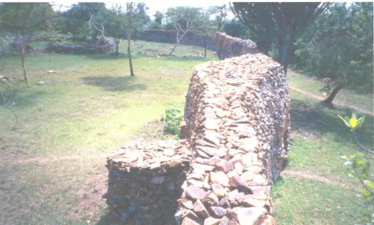
structure sites. Thimlich Ohinga is an example of a complex-structure site. Wherever they occur, the structures have walls of neatly arranged stones in a 3-phase design rising to heights of up to 4.2 meters. They are circular in shape with uniform entrances of about 1.5 square meters. The stones were never dressed or shaped and only skilfully arranged in an interlocking pattern within the 3-phase design to enhance stability, as seen in Figure 2 below.
Figure 2. Thimlich Ohinga Complex site showing a section of the wall with interlocking pattern and 3-phase design used in construction for structural stability
The complex-structure sites exhibit carefully planned use of space with animal areas, human areas, common areas and corridors and paths clearly marked. The outlay presents an opportunity to research on how the occupants created and used space at the time when the sites were occupied. Future studies should focus on unraveling the use of space and show to what extent humans carried out all their activities which are archaeologically discernible within the prescribed areas.
From the oral traditions collected through a formulation of a central question of “who were the builders of the Ohingni?” and a planned background research to identify suitable informants for interview and the evaluation of the responses, the 521 structures are said to have been built by either the Bantu or Nilotic immigrants into the area (Onjala 1995). In a site like Thimlich, a list of occupants is given that includes Bantu speakers that eventually left the site and moved into northern Tanzania as the Nilotic Luo entered the region and took over the site.
The structures served as fortified settlements, providing protection for both humans and livestock against human enemies/invaders and wild animals. To effectively play this role, therefore, the structures were strategically located on high points mostly on hilly areas where there were also abundant raw materials for construction. Such high points also provided a wide view of the surrounding fields giving the occupants opportunities to check on any approaching enemies or what was taking place on the agricultural or grazing fields.
Environmental changes and the introduction of agriculture
Extensive and pervasive land cover change has been dominant in the East African region over the last 6,000 years (Marchant et al. 2018). Such changes have been associated with population growth, immigration, and movement of people for one reason or another within the region and around the lake. Fossil sediment records of pollen, phytoliths, starch and fungal spores, as well as diatom records from Lake Victoria sites, indicate environmental disturbances involving forest clearance, human settlements, cultivation, burning/fires and other anthropogenic activities showing marked environmental changes during the 6,000 years period but more so during the second millennium AD (Lejju 2005, Lejju et al. 2006, Stager et al. 2003, Battistel et al. 2016)
The start of the second millennium AD witnessed an enhanced precipitation around AD 1100 to 1200. Later on, however, long periods of drought were registered (1390–1420, 1560–1625, 1760–1840). These changes affected the environments within the Lake Victoria catchment area leading to famine situations that spread in most areas several kilometres from the shores of the lake. Later still, enhanced precipitation was registered from 1896 to 1964 and in 1997 (Lejju 2012).
Changing rainfall patterns experienced in the region triggered major fluctuations in vegetation cover with moisture reliant species thriving during enhanced precipitation periods while drought resistant species thriving during the reduced precipitation periods. Such fluctuations led to ecological shifts and balances which created new environments as both human and wild animals adjusted to fit within the changing conditions (Battistel
et al. 2016).
As the effects of wider environmental changes were being witnessed within the region, new settlements and human activities were registered which were to change the environmental equilibrium to some significant levels. Demand for forest resources, food and land for cultivation and settlement triggered off migrations and settlements within the region an exercise which climaxed around the 15th and 16th centuries AD within the
southwestern Kenya region (Ogot 1967, Ayot 1977). Vegetation covers in a number of areas were cleared and settlements established. Pollen records from around the lake show reduced number of large forest trees and an increase of open grassland species. Populations exploited different environments cutting trees for different uses, as well as, hunting down wild animals for meat. At the same time, agricultural land areas were set and utilized thereby changing natural landscapes into entirely agricultural landscapes.
From the oral traditions and the current or prevailing subsistence farming practices, agriculture in the region became the mainstay of the traditional economy of most people during the second millennium AD and particularly since the 18th century (Onjala 1995,
Onduru 2009). Reconstruction of agriculture and crops grown during this early period, however, remains dependent on oral tradition as archaeology has not been able to provide useful data from the many sites in the region.
Scholars (Hay 1972, Butterman 1979, Ndege 1993, Onduru 2006, Francis 1995) state that people who settled the southwestern Kenya region were initially livestock farmers but shifted to crop farming due to frequent outbreak of cattle epidemics which occurred in the 1880s and 1890s and even earlier. The shift could also have occurred due to the presence of tsetse fly that was a common and a major problem in the South and Central Nyanza region. There was also the occupation of higher grounds exhibited by the numerous stone structures mainly located on the hilly areas that were favorable for crop cultivation,
especially utilizing the fertile valleys below the settled areas. The introduction of iron hoes (nya-imbo in Dholuo) also contributed positively, although not directly to the shift to crop production in the region. Not directly due to the fact that crop production went on and was embraced by everybody, yet only a few people could afford the iron hoes that were sourced or bought from the Bantu (Samia) iron workers north of the Central Nyanza region. Majority of the farmers continued to use the traditional cultivation tool known as rahaya, which was wooden but still remained effective in tilling the land for crops to be planted.
The shift from Pastoralism to crop production had a number of impacts. For example, women who hitherto had little to do in terms of economic activities became more involved in farming with men doing only a small percentage of the activities relating to crop production. Archdeacon Farler (1882), noting from Reverend Wakefield’s article (1870), states that both men and women among the Luo participated in crop production even though women worked longer hours on the farm.
Crop production also affected the political systems, resulting into the emergence of more centralized political units than before (Ogot 1967). Pastoralism created a scenario where migratory pastoral groups could easily break or move away. The so-called “ruodhi” (chiefs), therefore, could easily lose control of their subjects whenever a section decided to move to other areas for purposes of looking for pasture. This changed as crop production was introduced leading to a more sedentary lifestyle for the communities with the chiefs now having more or less permanent subjects.
Another impact was that of an increasingly inequitable distribution of land where influential personalities, such as, chiefs, clan elders, diviners, and generally the rich (jomoko) allocated themselves more land. Such people and their subjects or descendants were, therefore, able to accumulate more wealth becoming richer at the expense of the poor (jochan).
In terms of the crops that were grown within the southwestern Kenya region, we have no archaeological evidence at hand but much information comes from the oral traditions recorded during the early periods when such crops were introduced in the region. Hay (1972) and Butterman (1979) mention sorghum (bel), finger millet (kal), speckled maize (oduma or bando), sweet potatoes (rabuon), pumpkin (budho), sesame (nyim), green grams (olayo), and vegetables (alodhe) as some of the crops that were grown during this period, especially in the pre-colonial period. This list conforms to the earliest documentary evidence for crops provided by Reverend Wakefield (1870) and cited by Archdeacon Farler (1882) and by Johnson (1886), who provides a wide list of crops that include sorghum, sweet potatoes, peas, beans, eleusine, pumpkins, tobacco and hemp.
Sorghum was the staple crop of the region from which the main dish kuon was made, as well as nyuka (porridge) and traditional beer (otia or mbare). The crop had medicinal value and treated running stomachs when consumed either in kuon or nyuka form. It also became popular as it was resistant to drought conditions and continues to be common along the lakeshore areas where rainfall amounts are usually not adequate for other crops.
Other important crops introduced into the area was the speckled maize (oduma
marachich), which was grown by the Luo and the Luhya (Hay 1972, Butterman 1979,
Thomson 1885), bananas and sweet potatoes which were believed to be non-indigenous to the region. In a recent paper (Marchant et al. 2018), maize (Zea mays), tobacco (Nicotiana
spp.), and tomatoes (Solanum lycopersicum) are seen to have made entry into East Africa
through the Caravan routes from the coast to the interior starting around AD 1300 and intensifying during the 18th and 19th centuries. These routes acted as conduits for spreading
New World crops even though the processes and timings of their introduction remains poorly documented. South East Asian domesticates, such as banana (Musa spp.), rice (Oryza
spp.), taro (Colocasia esculenta) and chicken (Gallus gallus) seem to have been introduced
to the East African region via the transoceanic biological transfers around and across the Indian Ocean from at least around 1,300 years ago and potentially significantly earlier. The introduction of such new crops had profound social and ecological consequences across parts of the region including the southwestern Kenya region (Marchant et al. 2018).
To conclude this section therefore, it is necessary to restate that sorghum and finger millet (Eleusine coracana) were the main crops planted as part of the introductory agricultural practices in the region (Figures 3 and 4). Their cultivation changed the landscape as agricultural farms added a new dimension to the previously existing environments. Finger millet was planted, harvested, and used to make porridge and special breads. It was also used to make alcoholic drinks, especially, the traditional beer—busaa or otia—among several communities in the region. Sorghum on the other hand has been known to provide the main staple diet for most families as discussed in the section below.
Other crops that were grown and formed part of the agricultural landscape include sweet potatoes, peas and a variety of vegetables that initially grew naturally but were slowly controlled and produced according to the seasons and on some structured calendar. As the millennium advanced, more crops were introduced into the area. These included maize, cassava, bananas, sim sim, and a variety of fruits, which had different origins.
Farmland activities involving ploughing, and planting, as well as harvesting, involved the use of simple tools, such as wooden hoes (Rahaya in Dholuo) and later on iron hoes. The soils were fertile and soft as a result of the activities of burrowing animals and could, therefore, be worked using these simple tools. After crops were harvested, they were dried and kept in special storage facilities depending on their nature to provide a food source until the next harvesting season.
Agricultural landscapes in the region further led to more changes in the environment. Oral tradition has it that in order to protect farms from animal damage, communities in Migori, Awendo sub-county dug long trenches to deter wild animals that normally moved from the present day Maasai Mara Game Park from accessing the farmlands and settled areas. The trenches are fast filling up unfortunately without any substantial archaeological investigation done on them.
Historical records, as well as oral tradition, identify a number of constraints in the field of agriculture within the southwestern Kenya and northern Tanzania regions. Good rainfall in this region would lead to good harvest and abundant food while less rainfall or drought would lead to food shortage that would trigger off a number of activities as members of different communities searched for food (Onduru 2009). Poor harvest was, therefore, a major constraint in the region and led to famine situations at different times. For example, in the early 20th century three major famines, namely Aseno in 1926,
Nyangweso in 1932 and Opande which occurred probably after the arrival of Europeans
were registered (Ochieng 1988). These famines were, however, not caused by rainfall failure alone but by the locust invasion of the crops during these years. These famines caused widespread human movements in search of food, and oral tradition records links with other areas such as northern Tanzania and interior communities, such as the Abagusi who supplied the Lake Region communities with cereals like finger millet. The famines also provided opportunities for the distribution and spread of the new agricultural crops within the region.
Figure 3. Photo of sorghum (Sorghum bicolor) which was the main staple food in southwestern Kenya and around the Lake Victoria shoreline
Figure 4. Finger millet (Eleusine coracana) which was one of the important crops used in southwestern Kenya and northern Tanzania
To conclude this section, therefore, it is noteworthy to state that the environment during the second millennium AD within the southwestern Kenya and northern Tanzania changed significantly. Vegetation cover steadily decreased due to fluctuating climatic conditions but, more so due to human activities in the region. Immigrants settled at different localities, especially taking over hilly areas and near-the-river fertile grounds. They built fortified stone structures on the hills (Onjala 1995) where there were readily available raw materials for this type of construction while they settled near rivers in order to exploit river resources and have access to water. Vegetation was, therefore, cleared or interfered with on most of the hills and other settled areas, hence, changing those environments. Introduction of agricultural activities further created new farming landscapes and features. While some of these changes can be inferred from the archaeological record, a
lot more remain unknown and more work is, therefore, required to gather information that can lead to a better understanding of agricultural development in the region and how this can be identified and supported using the archaeological record. So far there is scanty information on agriculture from the available archaeological record in the region.
Social-cultural change in southwestern Kenya
Social change refers to all significant alterations over time in behaviour patterns and cultural values and norms of an individual or a community of people. Such significant changes usually yield profound social consequences. The second millennium AD social-cultural changes within the southwestern Kenya region and northern Tanzania can be inferred from the dry stone architecture tradition, as well as being obtained from the oral traditions. The numerous stone structures that formed settlement areas inform us of a people or a community that embraced living together in large groups for one reason or another. The construction of such massive structures may reflect change from individual family life to community life where labor was pulled together to create new forms of settlement strategies. The communities were able to construct large fortified settlements that accommodated hundreds of people who shared resources and other values and norms.
Migration challenges as people moved into the southwestern Kenya brought immigrants together to forge ways and means of tackling their problems. This was an important trigger to social change. The hostile environments consisting of dangerous wild life, competition from other groups and the issue of identity and ownership all contributed to the social set up witnessed in the region in the later centuries of the second millennium AD.
Archaeological record, especially from the Iron Age periods, show social changes as reflected in the different ceramic styles and types (Lane et al. 2006). In such contexts, a holistic analysis of cultural materials within sites would give an understanding of socio-cultural aspects of the occupants identifying possible social hierarchies and reasons for social change. Within the southwestern Kenya region, and using the stone structures as archaeological units of analysis, it has not been possible to conclusively discuss the question of social-cultural change, as more data is required to arrive at better conclusions.
One understanding that is helpful and which is also carried in the oral literature is the emergence of lineages with particular heads as leaders in the region. Opportunities and constraints in this new area of settlement required a collective action in order to succeed. This gave rise to the formation of larger groups around particular lineages thereby forming communities with formidable force to carry out joint tasks of construction, defence, and forceful acquisition of new lands. Diverse resources including land for agricultural activities, therefore, led to concentrations of populations in particular sites. Such sites also became important trading centers and enhanced co-operation among communities, thereby creating what could be interpreted as near-centralized political units or organizations.
Management of people and subsistence resources is also believed to have been responsible for the construction of large multiple-structure sites like Thimlich Ohinga. The amount of labor required in the construction process pointed towards the existence of an authority that coordinated activities. The evidence for cattle keeping within the structures, for example at Thimlich Ohinga, is also reflective of a hierarchical society. The more kraals or cattle pence a structure has, the more animals and by extension the more important and richer the owner of such a kraal is.
The stone structures also tell of possible political authority of elite settlements such as Thimlich Ohinga. The complexity of design and architecture, features present in, on or around the complex, as well as, the volume of material culture present, all show that loyalty to a central authority was key to its establishment. This reflects stratification in society, therefore, indicating that by the time Thimlich Ohinga was being constructed, the communities had reached a level of social organization that reflects advanced political organization.
According to Hobley (1903), the Luo had powerful chiefs wherever they settled and their society or people were organized into chiefdoms. The chiefs were also diviners, for example Chief Gor Ogalo of Kanyamwa who remains a legendary figure until modern times. The chiefs also held political, religious, and military positions and were assisted by a Council of Elders (Buch Piny in Dholuo) composed of elders (jodong dhoudi), peacemakers (ogaye), and military leaders (osumba mirwayi). The position of chief was hereditary and was normally inherited by the first son from the first wife.
By the time of settlement in the southwestern Kenya region, and by the time most of the stone structures were built or maintained by the Luo immigrants, chiefdoms were already in existence and this political arrangement possibly enhanced the process of settlement and construction of the different structures that form the archaeological landscape in this region.
Another important indicator of social change is reflected in the trade goods. Wandibba (1986), while analyzing materials from an excavation at Thimlich Ohinga, identified foreign beads associated with the neighbouring Maasai community, indicating exchange/ trade interactions by the people. Earlier, the acquisition of the iron hoe (nya-imbo), which entrenched agricultural activities in the region involved trade with the Samia people who lived north of the Central Nyanza region. At this point, therefore, we see social interactions involving trade and other forms of exchanges that reflect social complexity hitherto less developed in the region.
In the overall, therefore, social transformation within the region may be explained in a number of diverse ways. Multiple immigrations make the whole issue complex as different social formations are witnessed at different levels. The importance of family units as witnessed at the beginning of the millennium disappears towards the middle of the millennium paving way to preferred community life which was very important at the climax of settlement challenges. Towards the end of the millennium this fabric was broken, as people resorted back to individual family units beginning in the colonial period. The developments during the colonial period, which included less migratory movements of people across the region further accelerated a shift from community life to individual family unit/settlements within the region. This also marked the end of the construction of stone structure enclosures within the region as families resorted to simple homesteads which they fenced using euphorbia (ojuok) plants. This situation continues to date in the region.
Conclusions, observations, and future directions
The overriding purpose of this paper was to share knowledge on the archaeology, environments, and the socio-cultural changes that occurred in the southwestern Kenya and northern Tanzania Regions during the second millennium AD when the region received an influx of immigrants. It is clear that there are more questions than answers when it comes to archaeology providing the answers to problems of environment and social-cultural change.
While it is evident that the stone structures present an important archaeological signature on the landscape within the region, it is not possible, using the currently available data or evidence, to use the structures to better understand wider aspects of the important topics of environmental and social-cultural change during the second millennium AD. Given this scenario, it is important to note the following.
(i) The southwestern Kenya region witnessed remarkable events during the second millennium AD. Being within the Lake Victoria Basin, it was affected by the climatic conditions of the basin leading to periods of high precipitation as well as, periods of less precipitation and droughts. Some of these conditions caused famines, which affected people forcing population movements in search of food and more arable land.
(ii) There were multiple episodes of migrations into the area and firm dates for each or most of these episodes is lacking from the archaeological and/or historical records. There is need, therefore, to collect more data of archaeological nature, as well as more refined oral literature for corroboration. Accurate dates from some of the sites that can yield dateable materials are also needed to enable us understand this period well during this period.
(iii) Many stone structures numbering about 521 within the southwestern Kenya region and more others from the northern Tanzania region remain the major archaeological signatures on the landscape at least for the larger part of the second millennium AD. Since most of these are prone to destruction, as they are not protected by any government laws, most are fast disappearing with the information scholars would use to understand the archaeology, environment, and socio-cultural change of this region.
(iv) More questions remain unanswered, especially regarding the origins of the stone structures and the development of agriculture in the region. Some of the crops discussed in this paper have no evidence in the archaeological record. Other source of information, such as use of palaeo-ecological evidence and the application of modern methods in excavation and recovery of palaeo-seeds should be applied in order to get more information. The same goes for the understanding of the origins and development of the stone structures where more data is required.
The following, therefore, should form the engagement of scholars as they seek to understand the southwestern Kenya region in the future.
(i) Dates for the structures and other social activities in the region: Historical records, oral literature and archaeological records must agree on specific dates for the structures and therefore be able to explain some of the events in the region in time and space. This is currently missing and creates confusion in understanding the dating of some of the important sites like Thimlich Ohinga. Researchers must think of coordinated efforts to provide secure dates to sort out this problem. There is need to carry out systematic excavations at various sites to see if there is any dateable material that could be used. Currently dates by Wandibba (1986) of 110±80 BC and 200±80 BC based on charcoal from Thimlich Ohinga are the only ones available. Recent samples for dating collected at Thimlich Ohinga and other sites are still undergoing the process and hopefully will give us updated dates for the sites.
(ii) Who were the builders of the stone structures? This is an interesting question, which needs to be addressed. Bantu or Nilotes? There are no typological variations or differences distinguish between the two categories of builders yet the two groups lived and used the structures at different times.
(iii) Demographic profile of the structures. There are both multiple-structure and single-structure sites within the region. How many people lived at these sites or enclosures? How many people were involved in their construction and how long did the construction process take? What was the entire population forming a community that would move to an area, build structures and eventually move elsewhere after being dislodged? Some of these questions need to be answered.
(iv) Use of space within the multi-structure and single-structure sites: design shows careful layout and use of areas within and around the sites. How were these spaces planned and utilized to minimize conflict and enhance enjoyment?
(v) Archaeological investigation. Only Thimlich Ohinga has been excavated yielding a number of artefacts consisting of ceramics, fauna, beads, and other materials. No other sites have been investigated, with no excavations at all. For a proper understanding of the entire region’s archaeology the investigation need to be expanded to other areas.
(vi) Effects on the environment and the trigger of environmental changes. GIS mapping distributional studies need to be carried out in order to understand the link between the structures and the environments within which they were found.
(vii) The builders of the stone structures were also farming communities as is held in the oral literature. What evidence can we get from the region to inform us of the early farming practices—crops, farmlands, tools used, uses for different crops/plants and calendars?
References
Anthony, B. 1972. Iron Age Archaeology in Kenya. Staff seminar paper 1971/1972, Department of History, University of Nairobi.
Ashley, Cery Z. 2010. “Towards a Socialised Archaeology of Ceramics in Great Lakes Africa.”
African Archaeological Review 27 (2): 135–63. https://www.jstor.org/stable/40863424
Ayot, Henry Okello. 1979. A History of the Luo Abasuba of Western Kenya from AD 1760 to 1940. Nairobi: Kenya Literature Bureau.
Battistel, Dario, et al. 2016. “Fire and Human Record at Lake Victoria, East Africa, During the Early Iron Age: Did Humans or Climate Cause Massive Ecosystem Changes?” The Holocene 27 (7): 997–1007. https://doi.org/10.1177/0959683616678466
Bessems, Ilse, et al. 2008. “Palaeolimnological Evidence for Widespread Late 18th Century
Drought across Equatorial East Africa.” Palaeogeography, Palaeoclimatology, Palaeoecology 259 (2): 107–20. https://doi.org/10.1016/j.palaeo.2007.10.002
Butterman, Judith Marianne. 1979. Luo Social Formation in Change; Karachuonyo and
Kanyamkago, C. 1800–1945. PhD Dissertation, Syracuse (NY): Syracuse University.
Campbell, John R. 2006. “Who Are the Luo? Oral Tradition and Disciplinary Practices in Anthropology and History.” Journal of African Cultural Studies 18 (1): 73–87. https://doi.org/10.1080/13696850600750327
Chittick, Neville. 1965. “A Note on Stone-Built Enclosures in South Nyanza, Kenya.” Man 65: 152–53. https://doi.org/10.2307/2796081
Farler, V.J.P. (Archdeacon). 1882. “Native Routes from Pangani to the Masai Country and the Victoria Nyanza.” Proceedings of the Royal Geographical Society. New Monthly Series, 4 (1882): 737–44.
Francis, Elizabeth. 1995. “Migration and Changing Divisions of Labour: Gender Relations and Economic Change in Koguta, Western Kenya.” Africa 65 (2): 197–216. https://doi.org/10.2307/1161190
Gelorini, Vanessa, & Dirk Verschuren. 2013. “Historical Climate-Human-Ecosystem Interaction in East Africa: A Review.” African Journal Of Ecology 51 (3): 409–21.
http://dx.doi.org/10.1111/aje.12045
Gillman, Clement. 1944. “An Annotated List of Ancient and Modern Indigenous Stone Structures in East Africa.” Tanganyika Notes and Records n° 17: 75–88.
Hay, Margaret. 1972. Economic Change in Luoland: Kowe, 1890–1945. PhD Dissertation, Madison: University of Wisconsin.
Herring, Ralph S. 1976. “The Influence of Climate on the Migrations of the Central and Southern Lwo. Kenya Historical Review, 4 (1): 35–62.
Hobley, C. W. 1903. “Anthropological Studies in Kavirondo and Nandi, The Journal of Victoria Nyanza.” Proceedings of the Royal Geographical Society. New Monthly Series 4(1903): 737–44. Johnson, Thomas C., Kerry Kelts, and Eric Odada. 2000. “The Holocene History
of Lake Victoria.” AMBIO: A Journal of the Human Environment 29 (1): 2–12. https://doi.org/10.1579/0044-7447-29.1.2
Johnston, Sir Harry H. 1886. The Kilima-Njaro Expedition: A Record of Scientific Exploration in
Eastern Equatorial Africa and a General Description of the Natural History, Languages, and Commerce of the Kilima-njaro Destric. London: Kegan Paul.
Lane, Paul, Ceri Ashley, & Gilbert Oteyo. 2006. “New Dates for Kansyore and Urewe Wares from Northern Nyanza, Kenya.” Azania: Archaeological Research in Africa 41 (1): 123–38. https://doi.org/10.1080/00672700609480438
Lejju, B. Julius. 2012, The Influence of Climate Change and Human-Induced Environmental
Degradation on Lake Victoria. Addis Ababa: Organisation for Social Science Research in
Eastern and Southern Africa (OSSREA).
Lejju, B. Julius, Peter Robertshaw, & David Taylor. 2006. “Africa’s Earliest Bananas?” Journal of
Archaeological Science 33 (1): 102–13. https://doi.org/10.1016/j.jas.2005.06.015
Lofgren, Laurel. 1967. “Stone Structures of South Nyanza, Kenya.” Azania: Archaeological
Research in Africa 2 (1): 75–88. https://doi.org/10.1080/00672706709511441
Marchant, Rob, et al. 2018. “Drivers and Trajectories of Land Cover Change in East Africa: Human and Environmental Interactions from 6000 Years Ago to Present.” Earth-Science Reviews 178 (March): 322–78. https://doi.org/10.1016/j.earscirev.2017.12.010
Ndege, Peter O. 1993. Struggles for the Market: The Political Economy of Commodity Production
and Trade in Western Kenya, 1929–1939. PhD Dissertation, Morgantown (WV): West Virginia
University.
Ochieng’, William Robert. 1974. An Outline History of Nyanza up to 1914. Nairobi: East African Literature Bureau.
Ogot, Bethwell A. 1967. A History of the Southern Luo. Volume 1: Migration and Settlement,
1500–1900. Nairobi: East African Publishing House.
Onduru, Timothy Ayieko. 2006. “Globalisation of a Rural Economy: Case Study of South Nyanza, Kenya, 1870 to 1920.” Paper presented at an International Conference: Re–Thinking Worlds
of Labor: Southern Africa Labor History in International Context, at the University of the
Witwatersrand, Johannesburg: South Africa, 28th to 31st July, 2006.
Onduru, Timothy Ayieko. 1992. Some Aspects of Economic Change in Kano, Kenya, 1850–1963. M.A. Thesis, University of Nairobi.
Onjala, Isaya. 2003. “Spatial Distribution and Settlement System of the Stone Structures of South-Western Kenya.” Azania: Archaeological Research in Africa 38 (1): 99–120. https://doi.org/10.1080/00672700309480359
Onjala, Isaya. 1995. Spatial Distribution and Settlement Systems: A Case Study of the South
Western Kenya Stone Structures. Unpublished M.A. Thesis, Department of History, University
Onjala, Isaya. 1990. A Contribution to the Study of the South Nyanza Stone Structures with Special
Emphasis on Architecture, Distribution and the Settlement History of the Region. Unpublished
B.A. Dissertation, Department of History, University of Nairobi.
Onjala, Isaya, Mzalendo Kibunjia, Frederick Odede, & Gilbert Oteyo. 1999. “Recent Archaeological Investigation along the Sondu Miriu River, Kenya.” Azania: Archaeological Research in Africa 34 (1): 116–22. https://doi.org/10.1080/00672709909511476
Plummer, Thomas, et al. 1999. “Research on Late Pliocene Oldowan Sites at Kanjera South, Kenya.” Journal of Human Evolution 36 (2): 151–70. https://doi.org/10.1006/jhev.1998.0256 Reid, Andrew. 2016. “Constructing History in Uganda.” The Journal of African History 57 (2):
195–207. https://doi.org/10.1017/S0021853716000268
Reid, Andrew. 1994. “Early Settlement and Social Organization in the Interlacustrine Region.” Azania: Archaeological Research in Africa 29–30 (1): 303–13.
https://doi.org/10.1080/00672709409511686
Robertshaw, Peter. 2010. “Beyond the Segmentary State: Creative and Instrumental Power in Western Uganda.” Journal of World Prehistory 23 (4): 255–69.
https://doi.org/10.1007/s10963-010-9039-x
Robertshaw, Peter. 1994. “Archaeological Survey, Ceramic Analysis, and State Formation in Western Uganda.” African Archaeological Review 12 (1): 105–31.
https://doi.org/10.1007/BF01953040
Robertshaw, Peter. 1991. “Gogo Falls: Excavations at a complex archaeological site east of Lake Victoria.” Azania: Archaeological Research in Africa 26 (1): 63–195.
https://doi.org/10.1080/00672709109511425
Robersthaw, Peter & David Taylor. 2000. “Climate Change and the Rise of Political Complexity in Western Uganda.” The Journal of African History 41 (1) : 1-28.
http://doi.org/10.1017/S0021853799007653
Schmidt, Peter R. 1997. Iron Technology in East Africa: Symbolism, Science, and Archaeology. Bloomington: Indiana University Press.
Schmidt, Peter R. 1990. “Oral Traditions, Archaeology & History: A Short Reflective History.” In Peter Roberthsaw (ed.), A History of African Archaeology, 252–70. London: James Currey; Portsmouth (NJ): Heinemann.
Stager, J. Curt et al. 2003. “A 10,000-Year High-Resolution Diatom Record from Pilkington Bay, Lake Victoria, East Africa.” Quaternary Research 59 (2): 172–81.
https://doi.org/10.1016/S0033-5894(03)00008-5
Storch, Anne. 2003. “Dynamics of Interacting Populations: Language Contact in the Lwoo Languages of Bahr el-Ghazal.” Studies in African Linguistics, 32 (1), 65–94.
Sutton, John E.G. 1993. “The Antecedents of the Interlacustrine Kingdoms.” The Journal of
African History 34 (1): 33–64. https://doi.org/10.1017/S0021853700032990
Thomson, Joseph. 1885. Through Masai Land. London, Scholarly Press Inc.
Tryon, Christian A., et al. 2016. “The Pleistocene Prehistory of the Lake Victoria Basin.”
Quaternary International, 404 (June): 100–114. https://doi.org/10.1016/j.quaint.2015.11.073.
Wakefield, Thomas (Reverend). 1870. “Routes of Native Caravans from the Coast to the Interior of Eastern Africa, Chiefly from the Information given by Sadi Bin Ahedi, a Native of the District near Gazi, in Udigo, a little North of Zanzibar.” Journal of the Royal Geographical Society 40 (1870): 303–38.
Wandibba, Simiyu. 1986. “Thimlich Ohingini.” Azania: Archaeological Research in Africa 21 (1): 134–134. https://doi.org/10.1080/00672708609511375
Webster, James Bertin, ed. 1979. Chronology, Migrations and Drought in Interlacustrine Africa, Londres: Longman; Halifax: Dalhousie University Press.
Wrigley, C.C. 1981. “The Problem of the Lwo.” History in Africa 8: 219–46. https://doi.org/10.2307/3171517.