HAL Id: hal-00296905
https://hal.archives-ouvertes.fr/hal-00296905
Submitted on 15 Sep 2005
HAL is a multi-disciplinary open access
archive for the deposit and dissemination of
sci-entific research documents, whether they are
pub-lished or not. The documents may come from
teaching and research institutions in France or
abroad, or from public or private research centers.
L’archive ouverte pluridisciplinaire HAL, est
destinée au dépôt et à la diffusion de documents
scientifiques de niveau recherche, publiés ou non,
émanant des établissements d’enseignement et de
recherche français ou étrangers, des laboratoires
publics ou privés.
Analysis of shallow failures triggered by the 14-16
November 2002 event in the Albaredo valley, Valtellina
(Northern Italy)
S. Dapporto, P. Aleotti, N. Casagli, G. Polloni
To cite this version:
S. Dapporto, P. Aleotti, N. Casagli, G. Polloni. Analysis of shallow failures triggered by the 14-16
November 2002 event in the Albaredo valley, Valtellina (Northern Italy). Advances in Geosciences,
European Geosciences Union, 2005, 2, pp.305-308. �hal-00296905�
SRef-ID: 1680-7359/adgeo/2005-2-305 European Geosciences Union
© 2005 Author(s). This work is licensed under a Creative Commons License.
Advances in
Geosciences
Analysis of shallow failures triggered by the 14–16 November 2002
event in the Albaredo valley, Valtellina (Northern Italy)
S. Dapporto1, P. Aleotti2, N. Casagli1, and G. Polloni2
1Department of Earth Sciences, University of Florence, Italy 2ENI-SNAMPROGETTI, Milano, Italy
Received: 24 October 2004 – Revised: 9 March 2005 – Accepted: 10 March 2005 – Published: 15 September 2005
Abstract. On 14–16 November 2002 the North Italy was
affected by an intense rainfall event: in the Albaredo valley (Valtellina) more than 200 mm of rain fell triggering about 50 shallow landslides, mainly soil slips and soil slip-debris flows.
Landslides occurred above the critical rainfall thresh-olds computed by Cancelli and Nova (1985) and Ceriani et al. (1994) for the Italian Central Alps: in fact the cumulative precipitation at the soil slips initiation time was 230 mm (in two days) with a peak intensity of 15 mm/h.
A coupled analysis of seepage and instability mechanisms is performed in order to evaluate the potential for slope fail-ure during the event. Changes in positive and negative pore water pressures during the event are modelled by a finite el-ement analysis of water flow in transient conditions, using as boundary condition for the nodes along the slope surface the recorded rainfall rate. The slope stability analysis is con-ducted applying the limit equilibrium method, using pore wa-ter pressure distributions obtained in the different time steps by the seepage analysis as input data for the calculation of the factor of safety.
1 Introduction
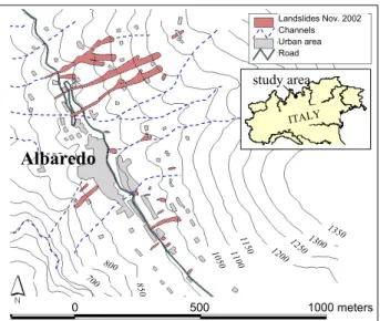
On 14–16 November 2002 Valtellina was affected by a pro-longed intense rainfall: in the middle and lower valley more than 200 mm fell triggering many geomorphic processes con-nected both to fluvial and slope dynamics (Aleotti and Pol-loni, 2003). The recorded landslides were mainly soil slips and debris flows but also large debris slides and deep seated instabilities occurred. In particular in the studied area (Al-baredo valley, left tributary of the Valtellina Valley) more than 50 shallow failures were inventoried, mainly involving natural slopes (Fig. 1).
Correspondence to: S. Dapporto
In order to determine the mechanisms that triggered land-slides, field observations were conducted as well as in situ and laboratory tests. A combined hydrological and stabil-ity analysis was then carried out, to evaluate the effects of positive and negative pore water pressures changes on slope instability.
2 Rainfall induced landslides
During the critical rainfall of the event, defined as the amount of precipitation from the time in which a sharp increase in rainfall intensity is observed and the triggering of the (first) landslide (Aleotti, 2004), the maximum intensities in the Al-baredo area were recorded in the afternoon of 16 November with a peak of 14 mm/h at 15:00 local time (LT) when the first landslides occurred. The cumulative rain at soil slip ini-tiation time was 230 mm corresponding to the 18% of the mean annual precipitation. Statistical analyses of rainfall data show that the return period for this meteoric event spans from 5 years for the 12 rainfall up to 100 years for the 60 h-rainfall.
Landslides occurred above the critical thresholds com-puted by Cancelli and Nova (1985) and Ceriani et al. (1994) for the Valtellina region and inside the “long heavy rainfall” field proposed by Moser and Hohensinn (1983). It is impor-tant to note that rainfall intensities higher than those recorded during the events that struck Valtellina on July 1987 and November 2000 were necessary to trigger the landslides, be-cause, unlike these events, the antecedent precipitation was very scarce (7 mm in the previous 15 days).
Landslides were soil slips and soil slip-debris flows affect-ing the quaternary cover up to a depth of 0.5–1.0 m. Slide breadth (B) and length (L) are usually less than 10 m and 50 m, respectively, with a prevalent B/L ratio from 0.1 to 0.5. Most failures occurred over slopes inclined from 35◦to 50◦ but the maximum frequency is observed in the 40–45◦class. All soil slips involved only grassland areas.
306 S. Dapporto et al.: Analysis of shallow failures
8 Figure 1. Landslide map in the Albaredo area.
1100 10 50 800 850 700 11 50 Landslides Nov. 2002 Channels Urban area Road 0 500 1000 meters
Albaredo
12501300 1200 1350 ITALY study area 1100 10 50 800 850 700 11 50 Landslides Nov. 2002 Channels Urban area Road 0 500 1000 metersAlbaredo
12501300 1200 1350 ITALY study areaFig. 1. Landslide map in the Albaredo area.
3 Geotechnical characterisation
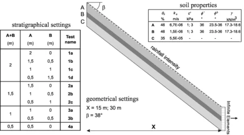
In situ and laboratory tests allowed to reconstruct the me-chanical behaviour of soils involved in the landslides. A rep-resentative site in terms of physiographic setting and mecha-nism of failure was selected for testing activity. The stratig-raphy at the landslide source area includes an upper collu-vial soil, 1.1 m thick, subdivided in two levels with different properties (A and B), overlying a 1 m thick coarse glacial deposit (C), and the bedrock (D) (Fig. 2). Failure surfaces are generally localised into the colluvial layers. Disturbed and undisturbed soil samples were collected at the landslide scars. According to the Unified Soil Classification System (USCS), layers A and B can be classified as silty sand with gravel (SM), with very low clay content (4% and 5%, respec-tively) and a uniformity coefficient greater than 70. Porosity ranges between 45% and 48%; dry unit weight varies be-tween 13.8 kN/m3and 14.3 kN/m3. Soils are not plastic, with a liquid limit of 30%.
Direct shear tests were conducted in remoulded samples with sieved particles finer than 2 mm, to eliminate bigger clasts that could have altered the determinations. The re-sults, in the 30 to 100 kPa stress range, indicate an effective friction angle (φ0) of 36◦and a negligible effective cohesion (c0=0.5 kPa).
The Borehole Shear Test (BST) was utilized to evaluate the shear strength parameters directly in situ. Tests were per-formed on soils under unsaturated conditions, with a mean matric suction of 6.5 kPa as resulted by tensiometric readings at the same depths as the BST tests. The BST provided a lin-ear relationship between the net normal stress and the shlin-ear strength in a stress interval ranging from 0 to 80 kPa, with φ0
values ranging between 35.8◦ and 37.5◦ and total cohesion (c) values ranging from 2.3 kPa to 8.8 kPa.
A Compact Constant Head Permeameter (Amoozegar, 1989) was used to perform in situ measurements of the
sat-urated hydraulic conductivity (ks). Measured values range
between 6.6E-6 m/s and 1.0E-5 m/s and between 1.5E-6 m/s and 1.6E-6 m/s for layers A and B, respectively.
4 Analysis of slope instability
4.1 Modelling scenarios
In the analyses different scenarios have been considered (Fig. 2), with variable slope length and thickness of the collu-vial layers (A and B). This allowed a parametric investigation of the most critical settings for slope stability. The modelled slope is geometrically a planar slope with soil layers parallel to ground surface. The thickness of layers A and B was al-lowed to vary between 0.5 m and 2 m and between 0 m and 1.5 m, respectively. Layer C, the glacial deposit, is instead included in all the simulations with a constant thickness of 1 m. Each stratigraphical configuration was tested adopting a slope angle (β) of 38◦and two different horizontal lengths (X): 15 m and 30 m.
4.2 Seepage and stability analysis
Transient saturated and unsaturated flow within the slope was modelled by a 2-D finite element code SEEP/W v.4 (Geo-Slope, 1998a). Hydraulic properties of A, B and C soils were derived both from experimental data and from the literature. In particular, porosity and hydraulic conductivity are those obtained by field and laboratory investigations, excepted for the glacial deposit (C) for which values were inferred based on its grain size distribution (Fig. 2). The characteristic curves and the hydraulic conductivity functions were ob-tained from curves derived from the literature for soils with a similar grain size distribution of the matrix, adjusting the sat-urated water content (θs)and permeability (ks)values to the
actual measured or assumed values for the three soil types. Initial conditions were defined assigning a matric suction of 6.5 kPa to the nodes. Regarding the boundary conditions, a transient flux function, with values equal to the rainfall rate of the event was applied to the nodes along the ground sur-face. A null flux condition was imposed at the lower bound-ary, therefore excluding any exchange of water between soil C and the bedrock. A null flux condition was also assigned to the upslope and downslope vertical faces of the model. How-ever, in the latter case the Infinite Elements option has been selected to extend the actual right edge to infinity in the pos-itive x-direction, to avoid an unnatural impermeable border and minimize any side effects. Finally, the simulations were performed dividing the event into 32 time steps of variable length, in order to replicate as closely as possible the varia-tions in rainfall intensities.
Slope stability analyses were conducted for each of the scenarios used for seepage analysis, using pore water pres-sures determined at different time steps as input data for a limit equilibrium analysis performed with SLOPE/W v.4 (Geo-Slope, 1998b) software. The factor of safety of the colluvial cover (A and B) was computed with the
9 Figure 2.Stratigraphical and geometrical settings, seepage finite element model and hydraulic and geotechnical parameters adopted in the analyses.
Fig. 2. Stratigraphical and geometrical settings, seepage finite element model and hydraulic and geotechnical parameters adopted in the analyses.
10 Figure 3. Test 2b. A) Pore pressure distribution, flux vectors, and critical failure surface at time step 22 (16:30 on 16 November) for 15 m and 30 m-long models; B) rainfall intensity and pore pressure changes versus time for all the three soils at a horizontal distance of 7.5 m from the downslope model boundary.
Fig. 3. Test 2b. A) Pore pressure distribution, flux vectors, and critical failure surface at time step 22 (16:30 on 16 November) for 15 m and 30 m-long models; B) rainfall intensity and pore pressure changes versus time for all the three soils at a horizontal distance of 7.5 m from the downslope model boundary.
Morgenstern-Price method. The geotechnical parameters adopted for layers A and B are reported in Fig. 2. Two sets of analyses were carried out, assigning two different effec-tive cohesion values (1 kPa and 3 kPa) to the soils, based on results of laboratory and in situ investigations.
5 Results
Figure 3a shows pore water pressure distribution, flux vectors and the most critical failure surface computed for Test 2b at time step 22, corresponding to 16:30 LT on 16 November, where maximum pore pressures were computed, for both the
15 m and 30 m long models. In Fig. 3b the pore pressure for soils A, B and C is plotted versus time for the same models at a horizontal distance of 7.5 m from the downslope edge of the section. It is interesting to note the different results ob-tained for the 15 m and the 30 m long models. In the shorter section a slight increase in pore water pressures takes place in the upper horizons immediately after the maximum rain-fall intensity, followed by a general decrease after the end of rainfall. During the whole simulation computed pore water pressures are always negative. On the contrary, in the lower reach of the 30 m long model a positive pore pressure pulse is recorded already after the second rainy day (15 Novem-ber), originating in the lower horizon (C) and progressively
308 S. Dapporto et al.: Analysis of shallow failures increasing in thickness. A temporary saturated zone
devel-ops and builds up to the surface, originated by the downslope flow parallel to the impermeable boundary at the bottom. The minimum factor of safety (SF) is computed for both mod-els at time step 22 and varies in the range 1.55–1.79 and 0.74–1.02 for the 15 m and the 30 m long sections, respec-tively, depending on the effective cohesion value adopted in the analysis (1–3 kPa). The computed time of landsliding is in agreement with witness reports for the November 2002 event.
6 Conclusions
The triggering mechanisms of the shallow failures that occurred in the Albaredo Valley during the 14–16 November 2002 meteoric event were analysed. The reconstruction of pore water pressure changes within the analysed sections allowed an accurate analysis of slope stability conditions to be accomplished. The analyses demonstrated that slope length is a fundamental parameter for generating pore pressure pulses and so instability conditions. This stresses the importance of upslope flow as well as groundwater convergence. For the analysed event, an effective cohesion of 3 kPa seems to constitute the critical value for the stability of 30 m long planar slopes.
Edited by: L. Ferraris
Reviewed by: anonymous referees
References
Aleotti, P.: A warning system for rainfall-induced shallow failures, Engineering Geology, 73, 247–265, 2004.
Aleotti, P. and Polloni, G.: Heavy rain triggered shallow failures in the Albaredo Valley (Italian Central Alps) during the November 14–16, 2002, Geophys. Res. Abstr., 5, 2003.
Amoozegar, A.: Compact constant head permeameter for measur-ing saturated hydraulic conductivity of the vadose zone, Soil Sci-ence Society of American J., 53, 1356–1361, 1989.
Cancelli, A. and Nova, R.: Landslides in soil debris cover triggered by rainstorm in Valtellina, Proc. 4th Int. Conf. and Field Work-shop on Landslides, Tokyo, 1, 267–272, 1985.
Ceriani, M., Lauzi, S., and Padovan, N.: Rainfalls and debris flows in the Alpine area of Lombardia Region, Central Alps – Italy, Mem. Soc. Geol. It., 48, 917–921, 1994.
Moser, M. and Hohensinn, F.: Geotechnical aspect of soil slips in Alpine regions, Engineering Geology, 19, 185–211, 1983. Geo-Slope Int. Ltd.: SEEP/W v.4 user manual, Calgary, Alberta,
1998a.
Geo-Slope Int. Ltd.: SLOPE/W v.4 user manual, Calgary, Alberta, 1998b.