HAL Id: insu-00337683
https://hal-insu.archives-ouvertes.fr/insu-00337683
Submitted on 7 Nov 2008HAL is a multi-disciplinary open access archive for the deposit and dissemination of sci-entific research documents, whether they are pub-lished or not. The documents may come from teaching and research institutions in France or abroad, or from public or private research centers.
L’archive ouverte pluridisciplinaire HAL, est destinée au dépôt et à la diffusion de documents scientifiques de niveau recherche, publiés ou non, émanant des établissements d’enseignement et de recherche français ou étrangers, des laboratoires publics ou privés.
Comment on “Magnetostratigraphic study of the Kuche
Depression, Tarim Basin, and Cenozoic uplift of the
Tian Shan Range, Western China” Baochun Huang,
John D.A. Piper, Shoutao Peng, Tao Liu, Zhong Li,
Qingchen Wang, Rixiang Zhu
Julien Charreau, Yan Chen, Stuart Gilder, Laurie Barier
To cite this version:
Julien Charreau, Yan Chen, Stuart Gilder, Laurie Barier. Comment on “Magnetostratigraphic study of the Kuche Depression, Tarim Basin, and Cenozoic uplift of the Tian Shan Range, West-ern China” Baochun Huang, John D.A. Piper, Shoutao Peng, Tao Liu, Zhong Li, Qingchen Wang, Rixiang Zhu. Earth and Planetary Science Letters, Elsevier, 2008, 268 (3-4), pp.325-329. �10.1016/j.epsl.2008.01.025�. �insu-00337683�
Comment on “Magnetostratigraphic study of the Kuche
Depression, Tarim Basin, and Cenozoic uplift of the Tian Shan
Range, Western China” Baochun Huang, John D.A. Piper,
Shoutao Peng, Tao Liu, Zhong Li, Qingchen Wang, Rixiang Zhu
[Earth Planet. Sci. Lett., 2006, doi:10.1016/j.epsl.2006.09.020]
Julien Charreau a, b, , Yan Chenb, , Stuart Gilderc and Laurie Barierd 1
a
Department of Geological Sciences, Indiana University, 1001 East 10th street, Bloomington 47405, Indiana, USA bInstitut des Sciences de la Terre d’Orléans; Bâtiment Géosciences, rue de Saint Amand, BP 6759, 45067 Orléans Cedex 2, France cLudwig Maximilians University, Department of Earth and Environmental Sciences, Geophysics Section, Theresienstrasse 41, 80333 Munich, Germany dInstitut de Physique du Globe de Paris, 4 place Jussieu, 75252 Paris Cedex 05 FRANCE
Abstract
The recent publication of “Magnetostratigraphic study of the Kuche Depression, Tarim Basin, and Cenozoic uplift of the Tian Shan Range,Western China” by B.C. Huang, J.D.A. Piper, S.T. Peng, T. Liu, Z. Li, Q.C. Wang, R.X. Zhu [Earth Planet. Sci. Lett., 2006,
doi:10.1016/j.epsl.2006.09.020] discusses the Cenozoic uplift history of the Tianshan Mountains by studying the magnetostratigraphy of Paleogene to Neogene continental sediments from two sections located in the Kuche basin at the northern edge of the Tarim basin. To support their conclusion they reinterpreted a magnetostratigraphic study of the Yaha section, which lies ~ 10 km south of their sections, we previously published [J. Charreau, S. Gilder, Y. Chen, S. Dominguez, J.-P. Avouac, S. Sen, M. Jolivet, Y. Li and W. Wang,
Magnetostratigraphy of the Yaha section, Tarim Basin (China): 11 Ma acceleration in erosion and uplift of the Tianshan Mountains, Geology 34(3), 2006, 181184.]. Here, (1) we argue that the interpretations of the sedimentation rate changes they proposed for the Kuche sections are partially invalid, (2) we disagree with their reinterpretation of the age of the Yaha section, and (3) we think that the way they interpret their AMS data is incorrect.
Keywords: Magnetostratigraphy; Tianshan; sedimentation rates; AMS; uplift
Understanding how and when the Tianshan mountains were built not only improves our knowledge of mountain building processes in general but also how deformation has propagated to form the vast area under the influence of the India-Asia collision. Numerous studies over the last few decades have been dedicated to unraveling the Tertiary history of this impressive mountain range (e.g., [Avouac et al., 1993], [Hendrix et al., 1994], [Métivier and Gaudemer, 1997], [Sobel and Dumitru, 1997], [Burchfiel et al., 1999], [Bullen et al., 2001], [Bullen et al., 2003], [Dumitru et al., 2001], [Sun et al., 2004], [Charreau et al., 2005], [Charreau et al., 2006] and [Sobel et al., 2006]). One commonly used tool is
magnetostratigraphy, which can decipher the history of the Tianshan from changes in the deposition rates of the sediments shed from the mountains and deposited in the foreland Junggar and Tarim basins ([Bullen et al., 2001], [Bullen et al., 2003], [Sun et al., 2004], [Charreau et al., 2005], [Charreau et al., 2006] and [Chen et al., 2001]).
Recently, Huang et al. (2006) published a magnetostratigraphic and rock magnetic study of Paleogene to Neogene continental sediments from two sections, separated by 2 km, located in the Kuche basin at the northern edge of the Tarim basin. These sections lie ~ 10 km north of the Yaha magnetostratigraphic section that we published in January of 2006 (Charreau et al., 2006). Changes in sedimentation rates derived from the magnetostratigraphic dating and changes in anisotropy of magnetic susceptibility (AMS) parameters led Huang et al. (2006) to suggest that the southern Tianshan underwent uplift pulses at ~ 20 Ma, at ~ 16-17 Ma, and then a more regional phase at ~ 7 Ma. The timing of these uplift pulses differ from the one we identified at Yaha around 10 to 11 Ma. Moreover, Huang et al. (2006) reinterpreted our Yaha magnetostratigraphic column, proposing that it should be shifted 3 million years younger in time than we originally found. Our motivation to write this comment is because (1) we think the interpretations of the sedimentation rate changes proposed by Huang et al. (2006) for their sections are partially invalid, (2) we disagree with their reinterpretation of the age of the Yaha section, and (3) we think that the way Huang et al. (2006) interpret their AMS data is
incorrect.
(1) Changes in sedimentation rates
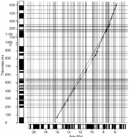
Fig. 1 plots thickness versus time for the Huang et al. (2006) data for their section A, which overlaps the Yaha section in time. According to the authors, sedimentation rate was constant from 16 to 7 Ma, then increased at ca. 7 Ma. Their interpretation is shown as a thick dashed line in Fig. 1. On the other hand, one can fit two linear segments to their data with a break at 10 to 11 Ma, compatible with that identified at the nearby Yaha section. This new
interpretation shows a relatively better fit when compared to their previous one. Whether or not a change in sedimentation rate occurred at 7 Ma is debatable because only four reversals define the break in slope, thus making the interpretation more tenuous.
Fig. 1. Age vs. depth plot of section A of Huang et al. (2006) according to their correlation. The thick dashed line shows the best-fit according to Huang et al. that yields an acceleration in the sedimentation rates at ~ 7 Ma. The black line represents our preferred fit, which suggests an acceleration in the sedimentation rate at ~ 10-11 Ma.
(2)Correlation of the Yaha magnetostratigraphic column
We dated the Yaha magnetostratigraphic section between 12.6 Ma and 5.2 Ma. Our
correlation suggests that sedimentation rate doubled at ~ 11 Ma. Also at ca. 11 Ma, an abrupt change in the AMS shape parameter T was observed. We interpreted these changes as the mark of increased uplift and concomitant erosion at that time. Thermochronological studies in the Tianshan also identify important changes at ca. 11 Ma ([Bullen et al., 2001] and [Bullen et al., 2003]).
Huang et al. (2006) proposed “an equally valid” correlation of our magnetostratigraphic scale with the reference geomagnetic polarity time scale (GPTS) (Berggren et al., 1995) between ~ 2 Ma (C2r.1n) and ~ 10 Ma (C5n.1n), which would make the Yaha section 3 million years younger in time than we proposed. Admittedly, in the absence of strong paleontological or radiochronological constraints, magnetostratgraphic correlation is a subjective, eye-based exercise based on pattern matching. Nevertheless, lithology, variations of sedimentation rate, statistical tests and basic diagrams can help quantify the quality of a given correlation. Huang et al. (2006) never presented depth/time diagrams or statistical analyses to argue why their reinterpretation should be considered better than that of Charreau et al. (2006).
Fig. 2 shows the correlations of our data with the GPTS (Berggren et al., 1995) made by us (left) and Huang (right). Our correlation contains 2 chrons that do not exist in the GPTS and 1 missing chron. We note that the one missing chron comes from lower in the section where the sedimentation rates are lower (~ 20 cm/ka). Besides these three, we successfully matched each chron with the GPTS. On the other hand, the Huang et al. (2006) correlation contains 2 chrons that do not correlate with the GPTS and 4 missing chrons. Considering the extremely high sedimentation rates imposed by the Huang et al. (2006) correlation, exceeding 50 cm/ka (Fig. 2b), the number of missed chrons is suspect, representing more than 10% of 36 chrons identified in the Yaha section.
Fig. 2. (a) Synthetic sedimentological column of the Yaha section (b) Age vs. depth plot of the Yaha magnetostratigraphic column section showing the correlations of Charreau et al. (2006) (black circles) and Huang et al. (2006) (gray circles). White boxes list the correlation coefficient (R2) for the different segments (c) plot of sedimentation rate against time calculated based on the Charreau et al. (2006) correlation (left) and the Huang et al. (2006) correlation (right).
Fig. 2. (a) Synthetic sedimentological column of the Yaha section (b) Age vs. depth plot of the Yaha magnetostratigraphic column section showing the correlations of Charreau et al. (2006) (black circles) and Huang et al. (2006) (gray circles). White boxes list the correlation coefficient (R2) for the different segments (c) plot of sedimentation rate against time
calculated based on the Charreau et al. (2006) correlation (left) and the Huang et al. (2006) correlation (right).
An important outcome of the age of the sampled Yaha section directly bears on the sedimentation rates of the strata that lie above the sampled part of the section, which is dominated by the conglomerate-rich Xiyu Formation. According to Hubert-Ferrari et al. (2007) who analyzed seismic lines across the Yaha section, there are ~ 2000 meters from the top of the magnetostratigraphic section to the top of the sedimentary pile at Yaha. Our correlation dates the top of the magnetostratigraphic section at 5.2 Ma. This implies the average sedimentation rate from the top of the section to the top of the Xiyu Formation is ~ 38 cm/ka, which is very similar to the mean instantaneous sedimentation rate of the upper half of the Yaha section based on our correlation (43 cm/ka). Huang et al.'s reinterpretation is that the top of our magnetostratigraphic section is ca. 2 Ma. This means that the average sedimentation rate must be 100 cm/ka, which well exceeds published average sedimentation rates for the entire Asian theatre by a factor of two. This is highly improbable.
In sum, we reject the reinterpretation of the Yaha magnetostratigrahic correlation offered by Huang et al. (2006) because: (1) their correlation has two times the number of missed or
unidentified chrons than ours (2) their correlation imposes more dramatic sedimentation rate variations, (3) their correlation predicts sedimentation rates about two-times higher than any previous study on continental sediments in Asia, and (4) extrapolation to the top of the sedimentary pile at Yaha imposes even more unrealistic sedimentation rates.
(3) Interpretation of Anisotropy of Magnetic Susceptibility Parameters
The magnetic fabrics of sediments yield information related to the deposition conditions acting when the sediments were deposited. Tectonic stress can overprint the sedimentary fabric, and thus magnetic fabrics of sediments can also be useful indicators of strain ([Pares et al., 1999], [Parès and Van der Pluijm, 2002], [Hrouda, 1991] and [Kanamatsu et al., 1996]). That the AMS data in the Huang et al. (2006) sections, as reflected by the principal axis directions, record strain is undisputable. However, Huang et al. (2006) interpret the age of the stress to be coeval with deposition; and thus, that the time-transgressive changes in the AMS parameters reflect the stress imposed on the sediments at the time of deposition. We object to this interpretation because there is no evidence to suggest that the sediments were
progressively deformed. Detailed structural geology work performed at the nearby Yakeng anticline, which is a pure-shear detachment fold, has a well-constrained history of growth beginning at 5.5 Ma (Hubert-Ferrari et al., 2007). The fact that the section lying closer to the deformation front yields greater degrees of anisotropy and better defined fabrics is typical of that found in orogenic fronts (Pares et al., 1999). The sediments toward the bottom of the section are also more clay rich, which react differently to stress than the coarser-grained sediments closer to the top of the sequence. The same was found at the Subei section (Gilder et al., 2001).
Of the two sections (called A and B) sampled by Huang et al. (2006), Section B is
characterized by declinations generally > 0° and lies closer to the Tianshan Mountains than Section A, which is characterized by declinations generally < 0°. Huang et al. (2006) argued that the change in declination within and between the two sections was progressive, with inferred clockwise rotation taking place from ca. 26 to 12 Ma, followed by counterclockwise rotation from 12 Ma to present. However, as pointed out by Gilder et al. (in press), an
anticline is situated at the northern part of Section A, in-between the two sections (see Fig. 1 of Huang et al., 2006). Because anticlines are often an expression of deep-seated thrust faults (Hubert-Ferrari et al., 2007), this structural discontinuity makes it plausible that the relative rotation between the two sections is due to a differential vertical axis block rotation, younger than ca. 5.5 Ma, again consistent with the deformation history at the Yakeng anticline
beginning at 5.5 Ma (Hubert-Ferrari et al., 2007). Moreover, paleomagnetic declinations from the Yaha section are identical to those from Section A, yet display no hint of a progressive rotation (Charreau et al., 2006). We also note that there is a marked difference in AMS
signature between the two sections that Huang et al. (2006) sampled. Thus, the abrupt changes in the AMS T, q and Pj parameters, which coincide with a structural break between the
sections, as marked by an anticline, opens the question whether the differences are linked to the way stress was transmitted to the rocks at the different sections. Thus, we interpret the AMS fabric as reflecting a tectonic overprint, which is Pliocene or younger.
1. Conclusions
We do not agree with the way Huang et al. (2006) defined changes in the sedimentation rate in the upper part of their sections, and we think that our re-analysis of their data support a change at 10-11 Ma, compatible with that seen at the Yaha section. Their suggestion of an
acceleration in sedimentation rates at ~ 7 Ma warrants more careful consideration. Changes in the AMS data do not reflect tectonic strain at the time of deposition as the authors believe, but instead are likely due to Pliocene-Pleistocene deformation. We dispute the reinterpretation by Huang et al. (2006) of the age of the Yaha section. Rather, from both studies we find that the Kuche Basin sediments recorded three main events at 20 Ma, 15 Ma and 10-11 Ma, which coincides with the conclusions of Charreau (2005).
Acknowledgements
This study was financed by the French INSU (Institut National des Sciences de l’Univers) program ECLISPE (Environnement et CLImat du Passé: hiStoire et Evolution), the Agence National pour la Recherche (ANR) program NT05-3-42850, the Franco-Chinese Program de Recherche Avancé (PRA) T05-02 and the Chinese project 2005CB422101.
References
Avouac et al., 1993 J.P. Avouac, P. Tapponnier, P. Bai, M. You and G.A. Wang, Active Thrusting and folding along the northern Tien Shan and late Cenozoic rotation of the Tarim relative to Dzungaria and Kazakhstan, J. Geophys. Res. 98 (1993), pp. 11.791–11.808. Berggren et al., 1995 W.A. Berggren, D.V. Kent, C.C. Swisher and M.P. Aubry, A revised geochronology and chronostratigraphy, Geochronology Time Sclaes and Global Stratigraphic
Correlation, SEPM Special Publication vol. 54 (1995).
Bullen et al., 2001 M.E. Bullen, D.W. Burbank, J.I. Garver and K.Y. Abdrakhmatov, Late Cenozoic tectonic evolution of the northwestern Tien Shan: New age estimates for the initiation of mountain building, Bull. Geol. Soc. Am. 113 (12) (2001), pp. 1544–1559. Bullen et al., 2003 M.E. Bullen, D.W. Burbank and J.I. Garver, Building the Northern Tien Shan: Integrated Thermal, Structural, and Topographic Constraints, J. Geol. 111 (2003), pp. 149–165.
Burchfiel et al., 1999 B.C. Burchfiel, E.T. Brown, D. Qidong, J. Li, X. Feng, P. Molnar, J. Shi, Z. Wu and H. You, Crustal Shortening on the Margins of the Tian Shan, Xinjiang, China,
Int. Geol. Rev. 41 (1999), pp. 663–700.
Charreau, 2005 Charreau, J., Tectonic evolution of the Tianshan mountains during Cenozoic time in response to the India-Asia collision: from Magnetostratigraphy and U-Th/He
thermochronology analysis of Neogene sediments, Phd Thesis, Orleans, 2005.
Charreau et al., 2005 J. Charreau, Y. Chen, S. Gilder, S. Dominguez, J.P. Avouac, S. Sevket, S. Dongjang, L. Yangan and W. Wei-Ming, Magnetostratigraphy and rock magnetism of the Neogene Kuitun He section (northwest China): implications for Late Cenozoic uplift of the Tianshan mountains, Earth Planet. Sci. Lett. 230 (2005), pp. 177–192.
Charreau et al., 2006 J. Charreau, S. Gilder, Y. Chen, S. Dominguez, J.P. Avouac, S.e.v.k.e.t. Sen, M. Jolivet, Y. Li and W. Wang, Magnetostratigraphy of the Yaha section, Tarim Basin (China): 11 Ma acceleration in erosion and uplift of the Tianshan Mountains, Geology 34 (3) (2006), pp. 181–184.
Chen et al., 2001 J. Chen, D.W. Burbank, K.M. Scharer, E. Sobel, Y. Jinhui, C. Rubin and Z. Ruibin, Magnetochronology of the Upper Cenozoic strata in the Southerstern Chinsese Tian Shan: rates of Pleistocene folding and thrusting, Earth Planet. Sci. Lett. 6075 (2001), pp. 1– 19.
Dumitru et al., 2001 T.A. Dumitru, D. Zhou, E.Z. Chang, S.A. Graham, M.S. Hendrix, E.R. Sobel and A.R. Caroll, Uplift, exhumation, and deformation in the Chinese Tian Shan. In: M.S. Hendrix and G.A. Davis, Editors, Paleozoic and Mesozoic tectonic evolution of central
Asia: From continental assembly to intracontinental deformation, Geological Society of America Memoir vol. 194, Boulder, Colorado (2001), pp. 71–99.
Gilder et al., 2001 S. Gilder, Y. Chen and S. Sevket, Oligo-Miocene magnetostratigraphy and rock magnetism of the Xishuigou section, Subei (Gansu Province, western China) and
implications for shallow inclinations in central Asia, J. Geophys. Res. 106 (12) (2001), pp. 30505–30521
Gilder et al., 2008 S.A. Gilder, J. Gomez, Y. Chen and J.P. Cogné, A New Paleogeographic Configuration of the Eurasian Landmass Resolves a Paleomagnetic Paradox of the Tarim Basin (China), Tectonics 27 (2008), p. TC1012.
Hendrix et al., 1994 M.S. Hendrix, T.A. Dumitru and A.S. Graham, Late Oligocene-early Miocene unroofing in the Chinese Tian Shan: An early effect of the India-Asia collision,
Geology 22 (1994), pp. 487–490
Hrouda, 1991 F. Hrouda, Models of magnetic variations in sedimentary thrust sheets,
Tectonophysics 185 (1991), pp. 203–210.
Huang et al., 2006 B. Huang, J.D.A. Piper, S. Peng, T. Liu, Z. Li, Q. Wang and R. Zhu, Magnetostratigraphic study of the Kuche Depression, Tarim Basin, and Cenozoic uplift of the Tian Shan Range, Western China, Earth Planet. Sci. Lett. 251 (3-4) (2006), pp. 346–364. Hubert-Ferrari et al., 2007 A. Hubert-Ferrari, J. Suppe, R. Gonzalez-Mieres and X. Wang, Mechanisms of active folding of the landscape (southern Tian Shan, China), J. Geophys. Res. 112, B03S09 (2007).
Kanamatsu et al., 1996 T. Kanamatsu, E. Herroro-Bervera, A. Taira, S. Saito and J. Ashi, Magnetic fabric development in tertiary accretionary complex in the Boso and Miura Peninsulas of central Japan, Geophys. Res. Lett. 23 (5) (1996), pp. 471–474.
Métivier and Gaudemer, 1997 F. Métivier and Y. Gaudemer, Mass transfer between eastern Tien Shan and adjacent basins (central Asia): constraints on regional tectonics, Geophys. J.
Int. 128 (1997), pp. 1–17.
Parès and Van der Pluijm, 2002 J.M. Parès and B. Van der Pluijm, Evaluating magnetic lineations (AMS) in deformed rocks, Tectonophysics 350 (2002), pp. 283–298.
Pares et al., 1999 J.M. Pares, B.A. van der Pluijm and J. Dinares-Turell, Evolution of magnetic fabrics during incipient deformation of mudrocks (Pyrenees, northern Spain),
Tectonophysics Applications of Magnetic Anisotropies to Fabric Studies of Rocks and Sediments vol. 307(1-2) (1999), pp. 1–14
Sobel and Dumitru, 1997 E.R. Sobel and T.A. Dumitru, Thrusting and exhumation around the margins of the western Tarim basin during India-Asia collision, J. Geophys. Res. 102 (B3) (1997), pp. 5043–5063.
Sobel et al., 2006 E.R. Sobel, M. Oskin, D. Burbank and A.V. Mikolaichuk, Exhumation of basement-cored uplifts: Example of the Kyrgyz Range quantified with apatite fission track thermochronology, Tectonics 25 (2006).
Sun et al., 2004 J. Sun, R. Zhu and J. Bowler, Timing of the Tianshan Mountains uplift constrained by magnetostratigraphic analysis of molasse deposits, Earth Planet. Sci. Lett. 219 (2004), pp. 239–253.