HAL Id: hal-00931351
https://hal.archives-ouvertes.fr/hal-00931351
Submitted on 24 May 2018
HAL is a multi-disciplinary open access
archive for the deposit and dissemination of
sci-entific research documents, whether they are
pub-lished or not. The documents may come from
teaching and research institutions in France or
abroad, or from public or private research centers.
L’archive ouverte pluridisciplinaire HAL, est
destinée au dépôt et à la diffusion de documents
scientifiques de niveau recherche, publiés ou non,
émanant des établissements d’enseignement et de
recherche français ou étrangers, des laboratoires
publics ou privés.
Holocene across the Italian Peninsula reconstructed
from pollen data
O. Peyron, M. Magny, S. Goring, S. Joannin, Jacques-Louis de Beaulieu, E.
Bruggiapaglia, L. Sadori, G. Garfi, K. Kouli, C. Ioakim, et al.
To cite this version:
O. Peyron, M. Magny, S. Goring, S. Joannin, Jacques-Louis de Beaulieu, et al.. Contrasting patterns
of climatic changes during the Holocene across the Italian Peninsula reconstructed from pollen data.
Climate of the Past, European Geosciences Union (EGU), 2013, 9, pp.1233-1252.
�10.5194/cp-9-1233-2013�. �hal-00931351�
Clim. Past, 9, 1233–1252, 2013 www.clim-past.net/9/1233/2013/ doi:10.5194/cp-9-1233-2013
© Author(s) 2013. CC Attribution 3.0 License.
EGU Journal Logos (RGB)
Advances in
Geosciences
Open Access
Natural Hazards
and Earth System
Sciences
Open AccessAnnales
Geophysicae
Open AccessNonlinear Processes
in Geophysics
Open AccessAtmospheric
Chemistry
and Physics
Open AccessAtmospheric
Chemistry
and Physics
Open Access DiscussionsAtmospheric
Measurement
Techniques
Open AccessAtmospheric
Measurement
Techniques
Open Access DiscussionsBiogeosciences
Open Access Open Access
Biogeosciences
DiscussionsClimate
of the Past
Open Access Open Access
Climate
of the Past
Discussions
Earth System
Dynamics
Open Access Open Access
Earth System
Dynamics
DiscussionsGeoscientific
Instrumentation
Methods and
Data Systems
Open Access
Geoscientific
Instrumentation
Methods and
Data Systems
Open Access DiscussionsGeoscientific
Model Development
Open Access Open Access
Geoscientific
Model Development
DiscussionsHydrology and
Earth System
Sciences
Open AccessHydrology and
Earth System
Sciences
Open Access DiscussionsOcean Science
Open Access Open Access
Ocean Science
Discussions
Solid Earth
Open Access Open Access
Solid Earth
Discussions
The Cryosphere
Open Access Open Access
The Cryosphere
Discussions
Natural Hazards
and Earth System
Sciences
Open Access
Discussions
Contrasting patterns of climatic changes during the Holocene across
the Italian Peninsula reconstructed from pollen data
O. Peyron1,2, M. Magny1, S. Goring3, S. Joannin4, J.-L. de Beaulieu5, E. Brugiapaglia6, L. Sadori7, G. Garfi8,
K. Kouli9, C. Ioakim10, and N. Combourieu-Nebout11
1Chrono-Environnement, UMR6249, Universit´e de Franche-Comt´e, Besanc¸on, France
2CBAE, UMR5059, CNRS, Univ. Montpellier 2, Montpellier, France
3Department of Geography, Univ. of Wisconsin-Madison, Wisconsin, USA
4LGLTPE, UMR5276, Universit´e Lyon 1, France
5IMBE, UMR7263, Universit´e Paul C´ezanne, Aix-en-Provence, France
6D. di Agricoltura, Ambiente e Alimenti, Univ. degli Studi del Molise, Campobasso, Italy
7Dipartimento di Biologia Ambientale, Universit`a di Roma “La Sapienza”, Roma, Italy
8CNR, Istituto di Genetica Vegetale, Corso Calatafimi, Palermo, Italy
9Dept. of Hist. Geology, University of Athens, Athens 10679, Greece
10Institute of Geology and Mineral Exploration, Olympic Village, Greece
11LSCE, UMR8212, Gif-sur-Yvette, France
Correspondence to: O. Peyron ([email protected])
Received: 15 November 2012 – Published in Clim. Past Discuss.: 29 November 2012 Revised: 8 March 2013 – Accepted: 17 April 2013 – Published: 14 June 2013
Abstract. Lake-level records from Italy suggest that pat-terns of precipitation in the central Mediterranean during the Holocene were divided between the north and south, but a scarcity of reliable palaeoclimatic records in the north and central-southern Mediterranean means new evidence is needed to validate this hypothesis. We provide robust quan-titative estimates of Holocene climate in the Mediterranean region using four high-resolution pollen records from north-ern (Lakes Ledro and Accesa) and southnorth-ern (Lakes Trifogli-etti and Pergusa) Italy. Multiple methods are used to provide an improved assessment of the palaeoclimatic reconstruc-tion uncertainty. The multi-method approach uses the pollen-based weighted averaging, weighted-average partial least-squares regression, modern analogue technique, and the non-metric multidimensional scaling/generalized additive model methods. We use independent lake-level data to validate the precipitation reconstructions.
Our results support a climatic partition between north-ern and southnorth-ern Italy during the Holocene, confirming the hypothesis of opposing mid-Holocene summer precip-itation regimes in the Mediterranean. The northern sites (Ledro, Accesa) are characterized by minima for summer
precipitation and lake levels during the early to mid-Holocene, while the southern sites (Trifoglietti, Pergusa) are marked by maxima for precipitation and lake levels at the same time. Both pollen-inferred precipitation and lake lev-els indicate the opposite pattern during the late Holocene, a maximum in northern Italy and a minimum in southern Italy/Sicily. Summer temperatures show the same partition-ing, with warm conditions in northern Italy and cool condi-tions in Sicily during the early/mid-Holocene, and a reversal during the late Holocene.
Comparison with marine cores from the Aegean Sea sug-gests that climate trends and gradients observed in Italy show strong similarities with those recognized from the Aegean Sea, and more generally speaking in the eastern Mediterranean.
1 Introduction
The Mediterranean region occupies a transitional zone be-tween mid-latitude and subtropical climates. The Mediter-ranean climate is commonly defined by wet/mild winters
and dry/warm to hot summers, but large areas within the Mediterranean do not share this Mediterranean type of cli-mate. The presence of strong mesoscale features that deter-mine large climatic gradients within a region is one of the characteristics of the Mediterranean region which would oth-erwise have a much more homogeneous climate (Lionello, 2012). Climate in the Mediterranean region is characterized by both large spatial variability and large temporal variabil-ity. The Mediterranean lies at the boundary of high-latitude atmospheric circulation and subtropical circulation, which is linked to the summer monsoon and trade wind activity (Trigo et al., 2006). The northwestern Mediterranean is under the in-fluence of mid-latitude climate regimes, while the Asian and African monsoons, controlled by tropical and sub-tropical circulation, are more important in the central and eastern basin areas (Lionello et al., 2006). In addition to atmospheric circulation and physiography, the Mediterranean Sea is it-self an important source of moisture and a heat reservoir for the region. Given these factors, the regional response to large-scale climate forcings is complex (Giorgi and Lionello, 2008). The peculiarities of the region and its response to climate change have driven intense research into Mediter-ranean climate over the last decade (Lionello, 2012). Future climate change can be expected to be particularly strong in this region and will likely have a marked impact on terres-trial ecosystems and on human societies. Therefore, a grow-ing interest in the region has focused on both the study of future and past climates.
The Holocene climate and ecology of the Mediterranean is particularly well investigated, with a large amount of data including palynological, speleothem, lake isotope and lake-level evidence (e.g. Magri and Sadori, 1999; Allen et al., 2002; Sadori et al., 2004, 2011; Zanchetta et al., 2007a, b; Colonese et al., 2011; Finne et al., 2011; Giraudi et al., 2011; Zhornyak et al., 2011; Magny et al., 2009, 2011, 2012a, b; Di Rita et al., 2013; Calo et al., 2012). These data show a com-plex pattern of climatic change across the Mediterranean dur-ing the Holocene, with strong spatial and temporal variabil-ity (e.g. Tzedakis, 2007; Peyron et al., 2011; Roberts et al., 2011). Recent lake-level records from Italy suggest a north– south partitioning of Holocene climate in the central
Mediter-ranean at ∼ 40◦N (Magny et al., 2012b). The northern sites
were characterized by summer precipitation minima during
the mid-Holocene, while the southern sites (south of 40◦N)
experience precipitation maxima at the same time. The parti-tioning of Mediterranean climate between the north and the south highlighted by Italian lake-level data is also apparent in the central and western Mediterranean, based on independent fire records (Vanni`ere et al., 2011).
Recent pollen-based reconstructions of precipitation from Lakes Accesa in north-central Italy, and Pergusa in Sicily support this interpretation of a north–south climatic parti-tion during the mid-Holocene (Peyron et al., 2011; Magny et al., 2012b). Climate reconstructions from Lake Accesa (north-central Italy) based on a multi-method approach
distinguish two distinct intervals based on precipitation: the mid-Holocene is characterized by a winter precipitation max-imum and a summer precipitation minmax-imum, while the late Holocene coincides with a decrease in winter precipitation and a slight increase in summer precipitation (Peyron et al., 2011). The Lake Pergusa pollen record (southern Italy, Sicily) shows the opposite pattern: maximum winter and summer precipitation during the early to mid-Holocene and a very moderate drying trend towards modern climatic con-ditions during the late Holocene (Magny et al., 2012b). The Sicilian record is supported by isotopic evidence from snail shells (Colonese et al., 2011), lacustrine records (Zanchetta et al., 2007a; Sadori et al., 2008) and stalagmites (Frisia et al., 2006). The Sicilian record also shows similarities to records from the eastern Mediterranean (Bar-Matthews and Ayalon, 2011; Bar-Matthews et al., 1998; Kouli et al., 2012) and the western Mediterranean (P´erez-Obiol and Sadori, 2007).
While the records from Lakes Accesa (Tuscany) and Per-gusa (Sicily) seem to support the interpretation of a north– south climate partitioning, the scarcity of reliable palaeocli-matic records in the central Mediterranean means that new evidence is needed to validate this hypothesis. This study aims to provide robust and precise quantitative estimates of Holocene climate for the central Mediterranean region based on four high-resolution pollen records taken from lakes lo-cated along a latitudinal gradient from northern to south-ern Italy. Three lakes are from peninsular Italy (Lake Ledro, Lake Accesa, Lake Trifoglietti), and one is from Sicily (Lake Pergusa). We investigate climatic trends during the Holocene to test whether reconstructions from pollen records can sup-port opposing mid-Holocene summer precipitation regimes across the north-central (minimum precipitation) and south-ern (maximum precipitation) Mediterranean (Magny et al., 2012b).
Special attention will be given to reconstructions of pre-cipitation and temperature seasonality, as was the case for Lake Accesa (Peyron et al., 2011). Reconstructions of sea-sonal precipitation and temperature from Accesa brought new insight into the role of seasonality in this region and proposed an explanation for discrepancies between pollen, lake levels and isotope data observed in north-central Italy by invoking changes in precipitation seasonality (Peyron et al., 2011; Magny et al., 2007, 2012b). In the current study, we aim to emphasize the effects of seasonality by exam-ining Holocene changes in precipitation seasonality across Italy. We will provide reliable quantitative estimates for sea-sonal climatic variables (summer and winter precipitation and temperature) from the four pollen records located in northern and southern Italy. Our purpose is to produce a cli-mate reconstruction that can be directly compared to Peyron et al. (2011). Here too, a multi-method approach is favoured for the reconstruction to better assess the error of reconstruc-tion inherent in pollen-based climate predicreconstruc-tions. We have chosen four methods: the weighted averaging method (ter Braak and Van Dam, 1989), the weighted-average partial
least-squares regression (ter Braak and Juggins, 1993), the best modern analogues technique (Guiot, 1990), and the non-metric multidimensional scaling/generalized additive model method (Goring et al., 2009).
Changes in the regional atmospheric circulation in the Mediterranean have clear consequences for precipitation and temperature during the Holocene (Tzedakis et al., 2009; Vanni`ere et al., 2011). Forcings such as the boreal insola-tion maximum (Tinner et al., 2009) and changes in the mean position of the Intertropical Convergence Zone (ITCZ) may influence the intensity and position of monsoons in the re-gion through the position and size of Hadley cells. Thus, this study also aims to better understand which climate processes can explain the inferred climate changes and the north–south partition.
2 Sites and data
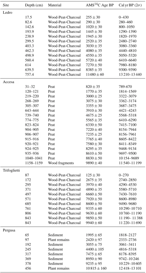
The core transect used in this study runs from north to south through Italy (Fig. 1), linking Lake Ledro, located on the southern slope of the Alps, to Lake Pergusa in Sicily. The sites are grouped into northern sites (Lake Ledro and Lake Accesa) and southern sites (Lake Trifoglietti and Lake Per-gusa) for the purposes of most subsequent analysis. For all sites we provide information on the radiocarbon dates used in constructing the chronologies (Table 1). Site age models are described in their original publications (referenced below).
2.1 Lake Ledro (northern Italy)
Lake Ledro (45◦870N, 10◦760E, 652 m a.s.l.) is a small lake
(area: 2.2 km2, max. depth: 48 m, catchment: 131 km2) in
northern Italy on the southern slope of the Alps. Mean
tem-peratures of the coldest and warmest months are 0◦C and
20◦C, respectively, measured at Molina di Ledro, close to
the lake’s outlet. Annual precipitation at Molina di Ledro ranges from ca. 750 to 1000 mm. Vegetation in the catch-ment is dominated by Fagus along with Abies. Higher in the Ledro Valley, the montane belt (650–1600 m) is charac-terized by Picea. The subalpine belt (1600–2000 m) is re-placed by grasslands above 2000 m. Lake Ledro flows into the nearby Lake Garda (65 m a.s.l). There, mild climate al-lows the development of a mixed oak forest with lime and elm trees, and Mediterranean vegetation such as Quercus
ilex, Ericaceae and olive trees that can reach 300 m a.s.l. in
the form of groves. More details about the site can be found in Magny et al. (2009), Vanni`ere et al. (2013) and Simonneau et al. (2013).
A profundal master core (LL081) was built using twin cores from an undisturbed sediment zone recognized using seismic reflection. Others cores have been obtained from other locations within Lake Ledro (Ledro I, Ledro II and Ponale: Magny et al., 2012a), but only the profundal LL081 is used in this study. The chronology spans the last 17 000 yr
SL 152 Pergusa Accesa Tenaghi P. Soreq Cave Preola Trifoglietti 30°E 0° 45° N 40° N 35° N 30° N 0 500 km AFRICA EUROPE NORTH ATLANTIC MEDITERRANEAN SEA BLACK SEA A dria tic S ea Lake Ledro Lake Accesa Lake Pergusa Ledro MNB-3 NS14 HCM2-22 lake-level record pollen and lake-level speleothem record pollen record
marine pollen record Lake Trifoglietti 15°E Enna (965m asl) 0 50 100 150 200 250 300 0 5 10 15 20 25 30 0 50 100 150 200 250 300 0 5 10 15 20 25 30 Trento (200 m asl) JA N FE B M A R A P R M A Y JU N TU L A U G S E P O C T N O V D E C JA N FE B M A R A P R M A Y JU N TU L A U G S E P O C T N O V D E C P (mm) T (°C) P (mm) T (°C) 0 50 100 150 200 250 300 0 5 10 15 20 25 30 Grosseto (7 m asl) JA N FE B M A R A P R M A Y JU N TU L A U G S E P O C T N O V D E C P (mm) T (°C) 0 50 100 150 200 250 300 JA N FE B M A R A P R MAY JUNTULAUGPESOCTNOVDEC 0 5 10 15 20 25 30 Fagnano Castello (516m asl) P (mm) T (°C)
Fig. 1. Geographic location of the study sites along a latitudi-nal gradient from northern Italy to southern Italy: Lakes Ledro
in northern Italy (45◦870N, 10◦760E, 652 m), Accesa (42◦590N,
10◦530E, 157 m) in north-central Italy, Trifoglietti in southern Italy
(39◦330N, 16◦010E; 1048 m), and Pergusa (37◦310N; 14◦180E,
667 m) in central Sicily. Other sites mentioned in the text and om-brothermic diagrams are also plotted.
using 1314C dates (Table 1) and 1 date from the Ledro II
littoral site (Magny et al., 2012a) aligned using stratigraphic comparison. The temporal resolution is approximately esti-mated to 66 yr / sample throughout the Holocene (more de-tails are given in Joannin et al., 2013).
Holocene vegetation at the site shows the development of a mixed-oak forest followed by successive expansion of trees in the montane belt and beech forest (Fig. 2). Hu-man land-use activity and forest exploitation begins at ca. 7500 cal yr BP. This accelerates during the late Holocene (from 4100 cal yr BP onwards) through continuous records of anthropogenic pollen indicators and drops in arboreal pollen percentages. More details on the Lake Ledro pollen, vegeta-tion and lake-level history are given in Joannin et al. (2013) and in Magny et al. (2009, 2012a).
2.2 Lake Accesa (Tuscany, central Italy)
Lake Accesa (42◦590N, 10◦530E, 157 m a.s.l.: Magny et al.,
Table 1. Chronologies: information on the radiocarbon dates used for each site.
Site Depth (cm) Material AMS14C Age BP Cal yr BP (2σ )
Ledro 17.5 Wood-Peat-Charcoal 255 ± 30 0–430 82.6 Wood-Peat-Charcoal 290 ± 30 280–460 142.6 Wood-Peat-Charcoal 1020 ± 30 800–1050 193.9 Wood-Peat-Charcoal 1445 ± 30 1290–1390 238.9 Wood-Peat-Charcoal 1945 ± 30 1820–1970 299.5 Wood-Peat-Charcoal 2520 ± 35 2480–2740 403.3 Wood-Peat-Charcoal 3030 ± 35 3080–3360 462.3 Wood-Peat-Charcoal 4080 ± 35 4440–4810 498.9 Wood-Peat-Charcoal 4550 ± 35 5050–5320 560.4 Wood-Peat-Charcoal 5720 ± 40 6410–6640 614 Wood-Peat-Charcoal 7270 ± 50 7980–8180 639.5 Wood-Peat-Charcoal 8385 ± 35 9300–9390 757.4 Wood-Peat-Charcoal 11480 ± 60 13 210–13 440 Accesa 31–32 Peat 820 ± 35 789-670 120–121 Peat 1770 ± 35 1814–1569 219–220 Peat 3000 ± 25 3322–3079 268–269 Peat 3075 ± 30 3362–3174 305–307 Peat 3355 ± 30 3687–3475 643–644 Peat 3910 ± 30 4421–4243 739–740 Peat 4675 ± 25 5568–5318 774–775 Peat 5565 ± 35 6410–6290 823–824 Peat 6330 ± 50 7415–7100 904–905 Peat 7220 ± 40 8154–7944 906–907 Peat 7235 ± 25 8156–7961 915–916 Peat 7765 ± 40 8605–8422 920–921 Peat 7580 ± 30 8411–8349 924–925 Peat 8295 ± 35 9468–9134 935–936 Peat 8610 ± 50 9697–9500 1040–1041 Peat 8830 ± 50 10 154–9689 1158–1159 Wood fragments 9890 ± 40 11 540–11 199 Trifoglietti 87 Wood-Peat-Charcoal 125 ± 30 0–270 172 Wood-Peat-Charcoal 2675 ± 35 2740–2850 295 Wood-Peat-Charcoal 3970 ± 40 4290–4530 371 Wood-Peat-Charcoal 4890 ± 35 5580–5710 497 Wood-Peat-Charcoal 6660 ± 50 7430–7610 571 Wood-Peat-Charcoal 7920 ± 50 8600–8980 685 Wood-Peat-Charcoal 8600 ± 50 9490–9680 761 Wood-Peat-Charcoal 9335 ± 60 10 290–10 710 806 Wood-Peat-Charcoal 9630 ± 60 10 760–11 190 843 Wood-Peat-Charcoal 9850 ± 50 11 190– 11 388 843 Wood-Peat-Charcoal 9940 ± 60 11 220–11 690 Pergusa 65 Sediment 1995 ± 65 1818–2127 97 Plant remains 2420 ± 97 2333–2736 192 Sediment 3055 ± 75 3061–3411 245 Sediment 4400 ± 105 4816–5318 317 Sediment 7475 ± 65 8178–8395 369 Sediment 8950 ± 90 9742–10 246 378 Sediment 9235 ± 95 10 229–10 605 456 Plant remains 10 815 ± 160 12 418–13 101
Peyron et al., 2011; Finsinger et al., 2010) is a small lake
(area: 16 ha, max. depth: 40 m, catchment area ca. 5 km2)
located in Tuscany, Italy, close to the eastern shore of the Tyrrhenian Sea, surrounded by low hills (ca. 300 m). The catchment area is characterized by gentle slopes, although steeper slopes around the lake’s outlet may be sensitive to the accumulation of colluvial deposits. Lake Accesa has a typi-cally Mediterranean climate with ca. 780 mm annual precip-itation, highest in autumn, with a marked summer drought.
Mean annual temperature is ca. 13◦C, ranging from 4.5◦C
in the coldest month to 22◦C in the warmest.
Although the Lake Accesa region is widely cultivated (ce-reals, vineyards and olive trees), vegetation in the region would likely be dominated by Quercus ilex (Ozenda, 1979). Existing woodland vegetation is sparsely distributed on the tops of hills, on some northern and northwestern slopes and in small shady valleys. Vegetation is characterized by open brush with Erica arborea, Arbutus unedo, Phillyrea,
Pistacia, Juniperus oxycedrus, Viburnum tinus, Spartium junceum, Cistus monspeliensis, C. salviifolius or open woods
with Pinus pinaster, Quercus ilex, Q. cerris, and Fraxinus
ornus, depending on the frequency and intensity of human
impact. The lake is surrounded by a small belt of
Phrag-mites/Carex.
A core transect was carried out from the western shore of Lake Accesa (Peyron et al., 2011). Pollen data for the cur-rent study were extracted from two overlapping cores, AC3 and AC4 (AC3/4), obtained in a littoral mire, 50 m from the
present-day lake shore. The chronology, based on 17 14C
dates and 4 tephra layers, spans the last 11 000 yr with a tem-poral resolution of 85 yr / sample (Table 1). Holocene veg-etation at Lake Accesa (Fig. 2) was dominated by decidu-ous Quercus (probably Q. pubescens at the beginning of the Holocene) and characterized by alternating dominance of de-ciduous and evergreen oaks. From 9500 to 7700 cal yr BP, high percentages of evergreen oaks are recorded, associated with high values of Abies (20 %). Regional Abies abundance may be overestimated from the littoral core, and may rep-resent only local abundance since increases in Abies alba pollen recorded in the deep Lake Accesa core are small (Colombaroli et al., 2008). A persistent decline of
Quer-cus ilex occurs around 7700 cal yr BP. The Lake Accesa core
indicates human presence since the Neolithic, but cereal cultivation and pasturing becomes more pronounced at ca. 4300 cal yr BP (early Bronze Age). More details on Lake Accesa pollen, lake levels and climate history can be found in Drescher-Schneider et al. (2007), Colombaroli et al. (2008), Magny et al. (2007), Vanni`ere et al. (2011), Finsinger et al. (2010), Sadori et al. (2011) and Peyron et al. (2011).
2.3 Lake Trifoglietti (Calabria, southern Italy)
Lake Trifoglietti (39◦330N, 16◦010E; 1048 m a.s.l.) is a
small, shallow lake (area: 0.97 ha, depth: 1.5 m,
catch-ment area: 0.37 km2) located 10 km from the Tyrrhenian
coast in the Catena Costiera Mountains, southern Italy, near Monte Caloria (1183 m). Climate at nearby Fagnano Castello
(Cosenza province) has a mean annual temperature of 15◦C,
(24◦C for August and 7.5◦C for January). Despite the
strictly Mediterranean latitude of the studied area, annual
precipitation (including cloudiness) is high (1849 mm yr−1),
though a relatively short dry period does occur in the sum-mer season (Joannin et al., 2012). Forest surrounding Lake Trifoglietti is dominated by Fagus with some Pinus nigra subsp. laricio. Scrub vegetation with Erica arborea and
Cis-tus salvifolius trees develops in more open forest. Quercus cerris and Castanea sativa trees occur at lower altitude.
A core transect was carried out from the northeastern shore of the lake and pollen data were extracted from overlapping cores (Joannin et al., 2012). The chronology, based on 11
14C dates, spans the last 11 500 yr with a mean temporal
res-olution of 68 yr / sample (Table 1). Holocene vegetation his-tory at Lake Trifoglietti (Fig. 2) shows relatively stable Fagus forest during the Holocene. Prevailing westerly winds may have driven pollen taxa such as oak, hazel and other Mediter-ranean taxa to the site from lower vegetation belts. Changes in algae, aquatic taxa and alder proportions at Lake Trifogli-etti are characteristic of changes in water depth associated with climatic change and the development of peatland at the site. The Trifoglietti pollen record shows only a weak sig-nal of human impact, apart from those indicating pastoralism beneath forest cover. The selective exploitation of Abies ap-pears to have been the strongest human impact in the region surrounding Lake Trifoglietti.
2.4 Lake Pergusa (Sicily)
Lake Pergusa (37◦310N; 14◦180E, 667 m a.s.l.: Sadori and
Narcisi, 2001; Sadori et al., 2008, 2011, 2013; Magny et al., 2012b; Zanchetta et al., 2007a) is a larger lake (area:
1.4 km2, depth: 12 m, catchment area: 7.5 km2)located in
central Sicily, Italy, about 5 km from the town of Enna. Arti-ficial drainage and lower lake levels, associated with reduced rainfall in the region, have resulted in the progressive salin-ization of the lake. Records from Enna show a local mean nual precipitation between 500 and 700 mm and a mean
an-nual temperature of 13.4◦C, ranging from 6◦C in the coldest
month to 24◦C in the warmest. Potential vegetation at Lake
Pergusa is mesophilous Mediterranean evergreen forest with prevailing Quercus ilex L., but the Lake Pergusa region is among the most open landscapes of Sicily, widely cultivated and dominated by xerophytic grasslands. The only traces of natural woody vegetation are sparse stands of deciduous and evergreen oaks (Quercus virgiliana, Q. ilex, Q. pubescens, Q.
suber and Rhamnus alaternus).
Pollen records have been obtained from two different lo-cations within Lake Pergusa: a 4.5 m long core (PRG1) pro-vided a record from 12 500 cal yr BP to the present (Sadori and Narcisi, 2001), while a second core (PG2) spans an interval from 6700 cal yr BP to the present (Sadori et al.,
20 20 40 20 20 20 40 20 0
PoaceaeCerealia Anthropogenic indicatorsArtemisia
Age cal. BP 20 Lake Ledro 0 1000 2000 3000 4000 5000 6000 7000 8000 9000 10000 11000 20 20 20 40 60 20 40 60 80 Age cal. BP 0 20 40 20 Lake Trifoglietti 0 1000 2000 3000 4000 5000 6000 7000 8000 9000 10000 11000 Picea Abies
Quercus deciduousCorylus Fagus JuglansCastanea Quercus robur tp.AbiesFagus Alnus Poaceae AnthropogenicArtemisia indicators
0 1000 2000 3000 4000 5000 6000 7000 8000 9000 10000 11000 20 20 20 40 60 20 20 40 20 40 60
Quercus pub/robur Quercus cerris/suber
Pinus Abies Quercus ilex-typeMedit. trees and shrubs Upland herbs incl. anthrop. indicators
0 Empty core Lake Accesa Age cal. BP 0 200 0 20 40 600 0 0 0 0 1000 2000 3000 4000 5000 6000 7000 8000 9000 10000 11000 0 Lake Pergusa Age cal. BP 20 20 40 20 40 20 40
Cerealia-typeChenopodiaceae Poaceae Ulmus
Quercus deciduous Quercus ilex-typeOlea Pistacia
Fig. 2. Simplified pollen diagrams for the following: Lake Ledro deep core “LL081” (Joannin et al., 2013), Lake Accesa littoral core “AC3/4” (Drescher-Schneider et al., 2007), Lake Trifoglietti (Joannin et al., 2012) and Lake Pergusa (Sadori and Narcisi, 2001). The chronology of the four pollen records is based on radiocarbon dates compiled in Table 1. More details on each chronology are given in the references papers.
2013). Results from the PRG1 pollen record have been ex-tensively reported (Sadori and Narcisi, 2001; Sadori and Giardini, 2007; Sadori et al., 2011; Magny et al., 2011). The PRG1 core is used in this study since it covers the entire Holocene (for more details on late Holocene vegetation and climate history based on the PG2 record, see Sadori et al.,
2013). The chronology, based on 814C dates and 1 tephra
layer, provides a mean temporal resolution of 131 yr / sample throughout the Holocene (Table 1). Holocene vegetation his-tory (Fig. 2) shows that deciduous and evergreen oaks dom-inated from 10 000 to 5000 cal yr BP (Sadori et al., 2011). Tree cover declined briefly from ca. 8900 and 8700 cal yr BP. Soon after 8000 cal yr BP, Olea begins to increase, indicat-ing the beginnindicat-ing of a climatic trend towards more arid con-ditions. Forested landscape around Pergusa opened at ca. 5500–5000 cal yr BP (Sadori et al., 2013). Although ancient pre-Greek, culturally evolved, civilizations were present in southern Italy since the early Holocene, agricultural activ-ities indicated by Secale, Linum and Vitis pollen are only recorded at Pergusa after 5000 cal yr BP. Human activities become more marked at 3000 cal ky BP, and increase signif-icantly over the last millenia. The landscape, as indicated by pollen, over the last millenia is clearly influenced by human impact more so than by climate with clear increases in olive tree, walnut, chestnut and cereal cultivation (Sadori et al., 2013).
3 Climate reconstruction methods
Individual pollen-based climate reconstruction methods have their own set of advantages and limitations (Birks and Birks, 2006; Brewer et al., 2008; Birks et al., 2010). For this rea-son we adopted a multi-method approach that would allow us to better assess reconstruction error and provide more pre-cise and robust climate estimates than those based on only one method (e.g. Klotz et al., 2003; Peyron et al., 2005, 2006; K¨uhl et al., 2010). Such an approach has been suc-cessfully tested for the Holocene from Mediterranean marine and terrestrial pollen records (Dormoy et al., 2009; Peyron et al., 2011, although see Birks et al., 2010). We chose four methods, including most standard methods, and based on different ecological concepts. Here, the modern ana-logue technique (MAT: Guiot, 1990), the weighted averaging method (WA: Ter Braak and Van Dam, 1989), the weighted-average partial least-squares regression (WAPLS: Ter Braak and Juggins, 1993), and the non-metric multidimensional scaling/generalized additive model method (NMDS/GAM: Goring et al., 2009) are used. The WA, WAPLS and the NMDS/GAM are true transfer functions based on a calibra-tion between environmental variables and modern pollen as-semblages, whereas the MAT does not require real calibra-tion and is based on a comparison of past assemblages to modern pollen assemblages. For all the methods presented here, we use the modern pollen dataset developed by Dormoy
et al. (2009), containing more than 2000 samples from the Mediterranean region with climate estimates for sites devel-oped by New et al. (2002). To improve reconstruction, we have updated the dataset by adding 26 modern surface sam-ples from around Lake Trifoglietti (Joannin et al., 2012), Mount Altesina close to Lake Pergusa (Sicily) and Lake Pre-ola (Sicily).
3.1 MAT
MAT reconstructs past climate parameters by considering proportion of pollen assemblages (Overpeck et al., 1985; Guiot, 1990). The MAT uses the squared-chord distance, effective with percentage data, to determine the degree of similarity between samples with known climate parameters (modern pollen samples) to a sample for which climate pa-rameters are to be estimated (fossil pollen sample). The smaller the chord distance is, the greater the degree of anal-ogy between the two samples. To calculate the climate pa-rameters for each fossil sample it is common practice to cal-culate the climate parameters as the weighed mean of the present-day climate of the closest n modern samples or “ana-logues”. A minimum “analogue” threshold is often estab-lished beforehand using a Monte Carlo method. Finally, the palaeoclimate is reconstructed by weighted averaging using modern climate data, here from New et al. (2002).
3.2 WA
The WA method (ter Braak and van Dam, 1989) is a trans-fer function that uses the (implied) unimodal responses of pollen taxa (in this case) along environmental gradients to infer climate by weighting taxon abundances from target as-semblages using the calibrated optima. While the assumption of unimodality is, in practice, violated by a large number of pollen taxa (see figures in Williams et al., 2006), Birks et al. (2010) have described the ways in which the strengths of WA might outweigh some of its limitations, accounting for its popularity in many modern studies.
3.3 WAPLS
WAPLS is a “classic” regression method which also assumes that the relationships between pollen percentages and climate are unimodal: each taxon grows best at a particular optimal value of an environmental variable and cannot survive when the value of that variable is too low or too high. If taxon ecology can be assumed to be constant through time, then, even if the overall pollen assemblage has no modern ana-logue, a reasonable reconstruction can be given. WAPLS op-erates by compressing the overall data structure onto latent variables. The modern pollen dataset used may be consid-ered a large multidimensional matrix. Since there is some co-linearity among pollen taxa, and since some taxa will be related to climate parameters of interest, it is possible to re-duce the dataset into a smaller number of components based
on both linear predictors of the parameter of interest and the residual structure of the data when those predictors are re-moved. The modification of PLS proposed by ter Braak and Juggins (1993) requires transformation of the initial dataset using weighted averaging (ter Braak and van Dam, 1989) along a gradient defined by the climate parameter of inter-est, such that the pollen taxa that best define the climate gra-dient are weighted more heavily than those that show little specificity to the gradient.
3.4 NMDS/GAM
This method, first developed from pollen assemblages in British Columbia, Canada (Goring et al., 2009), has re-cently been successfully tested on Mediterranean pollen as-semblages (Dormoy et al., 2009; Peyron et al., 2011). This method begins by reducing the dimensionality of the dataset using non-metric multidimensional scaling, a non-parametric ordination method that retains the dissimilarity structure of the data to generate low-dimensionality representations. In this way it is somewhat similar to the MAT, although the ordi-nation recovers not only the degree of dissimilarity between samples, but also the direction of dissimilarity. Once the low-dimensionality representation is generated, the NMDS/GAM method fits a generalized additive model to the ordination space to reconstruct the climate parameter of interest. Since this method uses non-parametric methods, specific statistical violations, such as the non-linearity of the relationship be-tween climate parameters and pollen taxa, may be avoided.
3.5 Validation of the methods and error calculation
To some degree all methods are subject to error resulting from “noise” in the dataset. This noise may result from ation in basin characteristics, co-variance of climate vari-ables, differential degradation of pollen taxa resulting from the deposition substrate, differences in pollen transport and local anthropogenic effects. The ecological noise is internal-ized differently in each pollen-based reconstruction method, although overlap exists among more closely related meth-ods (e.g. effects of spatial autocorrelation: Telford and Birks, 2005; effects of sample depositional environments: Goring et al., 2010). In general, as noise in the pollen dataset increases, model error increases. But as dataset size increases, many models become more robust (Birks et al., 2010). More details on the validation procedure used for pollen–climate calibra-tion with the European pollen dataset are given in Peyron et al. (2011).
Non-climatic factors may also affect pollen assemblages during the Holocene. Human impacts in particular have af-fected the natural vegetation of the Mediterranean since
∼7500 cal yr BP, but disentangling climatic and
anthro-pogenic causes of vegetation change is complex. For exam-ple, both human activity and climate may have resulted in the apparent aridification in Sicily and across the Mediterranean
Basin at 3500 cal yr BP (Sadori et al., 2013). While pollen records may be susceptible to change from anthropogenic ef-fects, previous studies show that human impacts on Mediter-ranean vegetation (using pollen as a proxy) are often hard to detect prior to the Bronze Age (Sadori et al., 2011; Mercuri et al., 2012). While human influences in the last 3000 cal yr BP are non-negligible, an unequivocal, widespread human sig-nature in this region only begins in the Roman period. Given this, it is likely that human impacts may influence pollen-based climate reconstruction, but the precise nature of these biases is difficult to assess due to a lack of pollen and climate data from “undisturbed” vegetation. Regardless of the extent of human influence, pollen-based climate reconstructions ap-pear to show robust results through time, particularly when other proxy data from stable isotopes, speleothems, tree rings or lake levels are used. Thus, we combine a multi-model ap-proach for pollen reconstructions with data from multiple proxies to provide broader support for our findings.
4 Results and discussion
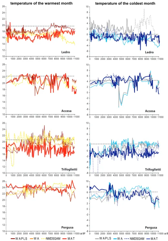
Quantitative climate reconstructions for each pollen se-quence were performed for summer and winter temperature in Fig. 3, and summer and winter precipitation in Fig. 4 to emphasize changes in seasonality.
4.1 A north–south climatic pattern? Looking at
the temperature reconstruction
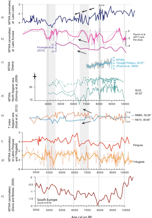
Climate reconstructions suggest the partitioning of Holocene summer temperature regimes between northern (Lakes Ledro and Accesa) and south-central (Lakes Trifoglietti and Per-gusa) Mediterranean sites (Figs. 3 and 5). Northern sites show warm conditions during the early to mid-Holocene, while cool conditions in Sicily are reconstructed during the same time period. This pattern reverses in the late Holocene, with southern sites warming and northern sites cooling. The partitioning of temperature trends is evident when results are expressed as anomalies (Fig. 5). Pollen-inferred temper-atures from Lake Ledro (north) show two distinct periods: relatively high temperatures before 7200 cal yr BP that are followed by a summer cooling trend from 7000 cal yr BP to 4600 cal yr BP. Pollen-inferred temperatures from Lakes Tri-foglietti and Pergusa (south; Figs. 3 and 5) show two distinct periods of temperature. Lake Ledro shows the opposite pat-tern, with cold temperatures before 6400–7000 cal yr BP, fol-lowed by an abrupt change towards warm summer conditions from 6400 cal yr BP to the present.
This pattern of climate partitioning between the north and the south is similar to partitioning in the eastern Mediter-ranean, particularly in the northern and southern Aegean Sea (Dormoy et al., 2009; Kotthoff et al., 2008, 2011). The cli-mate pattern observed in northern Italy from Lake Ledro (warm early to mid-Holocene followed by a summer cooling
temperature of the warmest month 10 12 14 16 18 20 22 24 26 0 1000 2000 3000 4000 5000 6000 7000 8000 9000 10000 11000 Ledro 10 12 14 16 18 20 22 24 26 0 1000 2000 3000 4000 5000 6000 7000 8000 9000 10000 11000 Accesa 10 12 14 16 18 20 22 24 26 0 1000 2000 3000 4000 5000 6000 7000 8000 9000 10000 11000 10 12 14 16 18 20 22 24 26 0 1000 2000 3000 4000 5000 6000 7000 8000 9000 10000 11000 Trifoglietti Pergusa -8 -6 -4 -2 0 2 4 6 8 10 0 1000 2000 3000 4000 5000 6000 7000 8000 9000 10000 11000 -8 -6 -4 -2 0 2 4 6 8 10 0 1000 2000 3000 4000 5000 6000 7000 8000 9000 10000 11000 -8 -6 -4 -2 0 2 4 6 8 10 0 1000 2000 3000 4000 5000 6000 7000 8000 9000 10000 11000 -8 -6 -4 -2 0 2 4 6 8 10 0 1000 2000 3000 4000 5000 6000 7000 8000 9000 10000 11000
temperature of the coldest month
Ledro Accesa Trifoglietti Pergusa W A P LS W A NMDSGAM M A T W A P LS W A NMDSGAM M A T cal BP cal BP
Fig. 3. Pollen-based temperatures (warmest and coldest month). Climate values are estimated using four methods: the modern analogue technique (MAT), the non-metric multidimensional scaling/generalized additive model method (NMDS/GAM), weighted averaging (WA), and weighted-average partial least-squares regression (WAPLS).
Modern values are indicated with a horizontal dotted line. The thin dotted grey curve (temperature of the coldest month, Ledro) corresponds to unrealistic values.
trend after 7200 cal yr BP) is similar to a pollen-based climate reconstruction from the northern Aegean Sea (marine core SL52, Fig. 5d: Dormoy et al., 2009). Further to the north, the Tenaghi Philippon (Greece) pollen-based temperature reconstruction (Fig. 5c) also provides evidence of high early
Holocene temperatures declining to the mid-Holocene (Pross et al., 2009). Moreover, Kouli et al. (2012) use a temper-ature index based on the ratio of cool to warm-temperate broadleaved taxa to show a Holocene summer temperature regime with strong differences between the northern and
0 50 100 150 200 250 300 0 1000 2000 3000 4000 5000 6000 7000 8000 9000 10000 11000 0 50 100 150 200 250 300 0 1000 2000 3000 4000 5000 6000 7000 8000 9000 10000 11000 0 50 100 150 200 250 300 0 1000 2000 3000 4000 5000 6000 7000 8000 9000 10000 11000 summer precipitation Ledro Accesa Pergusa W A P LS W A NMDSGAM M A T 0 50 100 150 200 250 300 0 1000 2000 3000 4000 5000 6000 7000 8000 9000 10000 11000 0 50 100 150 200 250 300 0 1000 2000 3000 4000 5000 6000 7000 8000 9000 10000 11000 0 50 100 150 200 250 300 0 1000 2000 3000 4000 5000 6000 7000 8000 9000 10000 11000 winter precipitation Ledro Accesa Trifoglietti Pergusa W A P LS W A NMDSGAM M A T 0 50 100 150 200 250 300 350 400 450 0 1000 2000 3000 4000 5000 6000 7000 8000 9000 10000 11000 800 mm 0 50 100 150 200 250 300 0 1000 2000 3000 4000 5000 6000 7000 8000 9000 10000 11000 Trifoglietti cal BP cal BP
Fig. 4. Pollen-based seasonal precipitation (winter = sum of Decem-ber, January, February precipitation, and summer = sum of June, July, August precipitation, in mm) values for the four lakes esti-mated with the methods listed in Fig. 3. Modern values are indi-cated with a horizontal grey dotted line. The thin dotted grey curve (summer precipitation, Ledro and Pergusa) corresponds to unrealis-tic values.
southern Aegean Sea based on three cores from the region. The north (core MNB3) is marked by warm conditions dur-ing the early to mid-Holocene, while the south (core NS14) remains cool. Following 6500–7000 cal yr BP, the pattern ap-pears to reverse, with cold conditions in the north culminat-ing around 4500 cal yr BP, while warm conditions exist in the south. The northern temperature index fits with the sum-mer cooling trend reconstructed from Lake Ledro (Fig. 5a and e), while the temperature index from the southeastern Aegean fits with the warming trend reconstructed from Lakes Accesa, Trifoglietti and Pergusa pollen data (Fig. 5d–g). The pattern of warm early to mid-Holocene temperatures and cooler late Holocene climate in the north is supported by alkenone-based SST curves from both records (Gogou et al., 2007; Triantaphyllou et al., 2009b). Alkenone-derived
SSTs range between 20◦ and 23◦C in the North Aegean
MNB3 record during the early to mid-Holocene and drop
to 20◦C after 6000 cal yr BP (Gogou et al., 2007). In
con-trast, the South Aegean record of core NS14 displays SSTs
ranging from 17◦to 22◦C for the early to mid-Holocene,
ris-ing to ∼ 24.8◦C at about 5000 cal yr BP (Triantaphyllou et
al., 2009b). Terrestrial biomarkers (n alkanes) indicate the dominance of warm species in the South Aegean during the mid- to late Holocene, confirming the pollen signal (Kouli et al., 2012) and agreeing with our pollen-based reconstruc-tions. Even at a regional scale, the Holocene climate signal reconstructed at Lakes Accesa, Trifoglietti and Pergusa fits with the summer temperature trend over Southern Europe
(south of 45◦N,), reconstructed by Davis and Brewer (2009)
in Fig. 5f–h.
4.2 A north–south climatic pattern? Looking at
the precipitation reconstruction
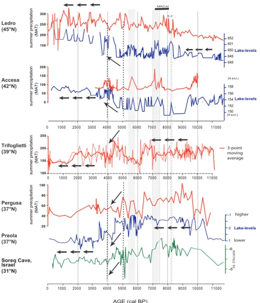
Pollen-inferred precipitation from Lakes Ledro and Accesa in the north, and Trifoglietti and Pergusa in the south, sug-gests a partitioning of the precipitation regime between the North and South Mediterranean during the Holocene (Figs. 4, 6 and 7). Relatively dry conditions in summer characterize the Lake Ledro record from 11 500 to 8500 cal yr BP, while precipitation in southern Italy and Sicily reaches a maxi-mum (Figs. 4 and 6). Pollen-inferred precipitation increases at Lake Ledro from 8200 cal yr BP to 4000 cal yr BP, reach-ing a maximum from 4000 cal yr BP to the present. The in-ferred climate from Lakes Trifoglietti and Pergusa in the south differs from Lake Ledro, showing two distinct peri-ods of precipitation change: with wet conditions prior to 6500 cal yr BP, followed by a trend towards dryer conditions from 6500 cal yr BP to 4500, and a period post 4000 cal yr BP with dry conditions.
A contrasting pattern between the northern and southern Mediterranean is also apparent in winter precipitation, even if relatively moist winter conditions seem to characterize the four sites’ areas during the Holocene (Fig. 4). The winter and summer precipitation trends reconstructed at Lake Ledro fit well; winter precipitation increases from 10 000 cal yr BP to 4000 cal yr BP, reaching a precipitation maximum from 4000 to the present, similar to the summer precipitation record. Lake Trifoglietti presents a problematic reconstruction, much below modern winter precipitation values for all methods, possibly due to specific aspects of its location (Joannin et al., 2012). Although reconstructed precipitation values at Lake Trifoglietti are low, we are still able to reconstruct a precipi-tation trend that fits well with Pergusa and Accesa, showing a “Holocene Optimum” between 9500 and 5000 cal yr BP fol-lowed by a trend towards aridification. At Trifoglietti, the two periods marked by high precipitation at ∼ 7200–6500 and 4900–4500 cal yr BP (Fig. 6) are almost synchronous with phases of high fluvial activity and floods recorded at 7200– 6800 and 4800–4550 cal yr BP in nearby Basilicata, southern
3000 4000 5000 6000 7000 8000 9000 10000 15
20
MTWA North Aegean sea, (Dormoy et al.,2009)
-2 -1.5 -1 -0.5 0
MTWA (anomalies) (Davis and Brewer, 2009)
4000 5000 6000 7000 8000 9000 10000 South Europe (South of 45°N) -6 -4 -2 0 2 Trifoglietti Pergusa 3000 4000 5000 6000 7000 8000 9000 10000
MTWA (anomalies) at Lakes Pergusa and Trifoglietti
-4 -2 0
MTWA (anomalies) at Lake Accesa
26 24 22 20 18 c) e) b) d) f) g) h) 20 22 Finsinger et al. (2010) Peyron et al. (2011) and this study 0.4 0.6 0.8 NS14, 36.65° MNB3, 39.26°
T index Aegean sea, (Kouli et al., 2012)
SL52, 40.32°
MTWA (anomalies) at Lake Ledro -4 -2 0 a) 8.2 ka MTWA Greece MTWA, Tenaghi Philipon, 40.97° (Pross et al., 2009)
Age cal yrs BP
Fig. 5. Synthesis figure for selected Mediterranean temperature records. (a) Pollen-inferred temperature of the warmest month for Lake Ledro (as for Fig. 3), MAT only. (b) Pollen-inferred temperature of the warmest month for (1, pink curve) Lake Accesa littoral core, MAT only (as for Fig. 3), and (2, purple curve) Lake Accesa profundal core, WAPLS only (Finsinger et al., 2010). (c) Pollen-inferred temperature of the warmest month for Tenaghi Philippon, Greece, MAT only (Pross et al., 2009). (d) Pollen-inferred temperature of the warmest month for the marine core SL152, Aegean Sea, (Dormoy et al., 2009) with three methods (short dotted line: MAT; blue line: PLS; long dotted line: NMDS/GAM). (e) Pollen-based temperature index “T index” for the marine cores MNB3 (North Aegean Sea), and NS14 (South Aegean Sea), (Kouli et al., 2012). (f) inferred temperature of the warmest month for Lake Pergusa (as for Fig. 3), MAT only. (g) Pollen-inferred temperature of the warmest month for Lake Trifoglietti (as for Fig. 3), MAT only; the curve of temperature is calculated with a moving average (bold curve) and raw values are also plotted (dotted curve). (h) Reconstruction of temperatures of the warmest month (anomalies) for Southern Europe based on pollen data from over 500 pollen sites from across Europe, MAT only (Davis and Brewer, 2009; Davis et al., 2003).
-5 -6 -1 0 1 δ18 O (‰) calcite higher lower Soreq Cave, Israel (31°N) 158 156 154 152 150 (m a.s.l.) (m a.s.l.) 652 651 650 649 648 0 1000 2000 3000 4000 5000 6000 7000 8000 9000 10000 11000 Lake-levels Lake-levels Lake-levels 150 200 250 300 summer precipitation (MAT) 0 50 100 150 200 20 40 60 80 100 3-point moving average 8.2 MRCAI 0 1000 2000 3000 4000 5000 6000 7000 8000 9000 10000 11000 Ledro (45°N) Accesa (42°N) Trifoglietti (39°N) Pergusa (37°N) Preola (37°N) summer precipitation (MAT) summer precipitation (MAT) summer precipitation (MAT) AGE (cal BP) 100 150 200 250 0 1000 2000 3000 4000 5000 6000 7000 8000 9000 10000 11000
Fig. 6. Comparison between pollen-inferred summer precipitation (MAT only) and lake-level variations at Lakes Ledro, Accesa, Trifoglietti and Pergusa. More details on the lake-level data are given in Magny et al. (2012a) for Lake Ledro, Magny et al. (2007) for Lake Accesa, and Magny et al. (2011) for Lake Preola (Sicily). Oxygen isotope data based on speleothem from Soreq Cave, Israel, is also plotted for comparison with eastern Mediterranean sites (Bar-Matthews and Ayalon, 2011; Bar-Matthews et al., 1998; Vaks et al., 2006). MRCAI = period of maximal rate of change in annual insolation.
Italy (Piccarreta et al., 2011). The correlation between the precipitation reconstruction and independent assessments of hydrological activity may indicate that, while the reconstruc-tion values may be offset strongly at Lake Trifoglietti, the anomaly trends are consistent with long-term change in re-gional precipitation.
One goal of this study is to test the hypothesis proposed by Magny et al. (2012b) that mid-Holocene summer pre-cipitation regimes are partitioned and that north-central and southern Mediterranean patterns of change are in opposition to one another. This assumption is based on lake-level vari-ations established for Italy from carbonate concretions pro-duced during summer (Magny et al., 2011). Figure 6 shows a direct comparison between independent Holocene lake-level
changes and the pollen-inferred summer precipitation for Lakes Ledro and Accesa. Summer precipitation estimated for the southern Lakes Trifoglietti and Pergusa are compared to the Lake Preola lake-level reconstruction from coastal Sicily (Fig. 6; Magny et al., 2011). The lake-level and pollen-based climate reconstructions both suggest climatic parti-tioning during the Holocene. These opposing patterns appear (1) during the early to mid-Holocene, when the northern sites (Ledro, Accesa) are characterized by a minimum in summer precipitation and associated lake-level minimum, while the
sites located south of ca. 40◦N (Trifoglietti, Pergusa) are
marked by high precipitation and associated high lake lev-els and (2) during the late Holocene when pollen-inferred precipitation and lake-level reconstructions indicate maxima
in northern Italy and minima in the south. These findings are further supported by a synthesis of fire activity for the Mediterranean Basin (Vanni`ere et al., 2011). Low fire ac-tivity was observed in the southern Mediterranean (south of
40◦N) during the mid-Holocene (ca. 7500–4500 cal yr BP),
while northern Mediterranean records suggest a contempo-raneous increase in fire activity. The north–south climatic partition in Italy highlighted in our study is also apparent in the central and western Mediterranean from independent fire records (Vanniere et al., 2011). Relatively abrupt changes in fire activity are observed ca. 5500–5000 cal yr BP, at ap-proximately the same time as the climate transition recorded ca. 5000 cal yr BP by the lake-level and summer precipitation records from Italy (Fig. 6).
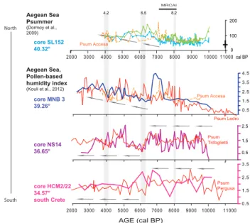
The climate trend observed in southern Italy and Sicily shows strong similarities to the Soreq Cave speleothem record (Israel; Bar-Matthews et al., 1998) from the eastern Mediterranean (Magny et al., 2012b, Fig. 6). A similar cli-mate pattern also exists from records in the Aegean Sea (Fig. 7) based on (1) a relative “humidity index” established from the three marine pollen records located across a north– south transect in the Aegean Sea (Kouli et al., 2012), and (2) the pollen-based climate reconstruction from marine core SL52 located in the North Aegean Sea (Dormoy et al., 2009). The humidity index (Fig. 7) shows a climatic partition during the Holocene that matches well with the pollen-based pre-cipitation reconstructions: the mid-Holocene is characterized by dry summer conditions in northern Italy and the North Aegean Sea, while wet conditions are reconstructed in south-ern Italy, Sicily and South Crete. Warm and humid condi-tions that prevailed during the mid-Holocene are also appar-ent in the South Aegean marine NS14 record by the deposi-tion of a distinguishable sapropel-like layer (Sapropel mid-Holocene: SMH, Triantaphyllou et al., 2009b). The trend of warm and humid conditions in the south reverses during the late Holocene, after 6000 cal yr BP.
A shift in climate at ca. 4500 cal yr BP is clear from sum-mer precipitation, lake-level and speleothems records from the region (Fig. 6). This shift is also seen in the eastern Mediterranean by Finn´e et al. (2011). Palaeoclimate records in the eastern Mediterranean reconstruct wet conditions from 6000 to 5400 cal yr BP followed by a period of drying that develops into aridity by ca. 4600 cal yr BP. Climate changes around 4500 cal yr BP may have resulted from large-scale changes in the atmospheric circulation affecting the southern Mediterranean area over the mid- to late-Holocene transition (Magny et al., 2009). Changes could be linked to a non-linear response of the climate system to the gradual decrease in in-solation in addition to other key seasonal and interhemispher-ical trends related directly to changes in insolation.
AGE (cal BP) core NS14 36.65° core HCM2/22 34.57° south Crete core MNB 3 39.26° 2.5 1.5 0.5 2000 3000 4000 5000 6000 7000 8000 9000 10000 11000 Psum Ledro Psum Pergusa MRCAI Psum Accesa Aegean Sea, Pollen-based humidity index (Kouli et al., 2012) North South Aegean Sea Psummer (Dormoy et al., 2009) 6000 7000 8000 9000 10000 11000 4000 5000 cal BP 0 200 100 core SL152 40.32° 2000 3000 Psum Accesa 8.2 6.5 4.2 0.5 1.5 2.5 3.5 0.5 1.5 2.5 3.5 4.5 Psum Trifoglietti
Fig. 7. Contrasting precipitation patterns in Italy and in Aegean Sea during the Holocene. Psum = Psummer (MAT only) as in Fig. 4, from each lake pollen record (dotted orange: Accesa; red: Ledro, Trifoglietti and Pergusa; units same as Fig. 6).
Comparison with the Aegean Sea records. (1) Pollen-inferred sum-mer precipitation (in mm) for the marine core SL152, North Aegean Sea (Dormoy et al., 2009), obtained with the PLS method (green curve), and the NMDS/GAM (blue curve); (2) pollen-based hu-midity index established by Kouli et al. (2012) from three marine pollen records located across a north–south transect in the Aegean Sea: cores MNB3 (blue curve), core NS14 (purple curve) and core HCM2/22 (dark pink curve). Short events at around 8200, 6500 and 4200 cal yr BP are also plotted. MRCAI = period of maximal rate of change in annual insolation.
4.3 Short-term events around 8000, 6500 and
4200 cal yr BP
Short-term Holocene climate events are evident in the pollen-inferred climate reconstruction for Lakes Ledro and Trifogli-etti (and to a lesser extent at Lake Pergusa). These short-lived events occur at ca. 8000, 6500 and 4200 cal yr BP and they correspond to strong shifts in the humidity index recon-structed from the Aegean cores.
The earliest event seems to correspond with the regional expression of the 8.2 kyr event (Alley et al., 1997) in the Mediterranean region (Magny et al., 2003, 2007; Kotthoff et al., 2008, 2011; Pross et al., 2009; Triantaphyllou et al., 2009b). This event is commonly explained through atmo-spheric circulation changes induced by freshwater pulses that produced a weakening of the thermohaline circulation in the North Atlantic. This allowed an expansion of the Eurasian/Siberian High, ultimately resulting in colder and drier winters (Renssen et al., 2002; Rohling et al., 2002). The multi-method approach for Lake Ledro indicates a
win-ter temperature drop > 3◦C (Fig. 3) and a summer
corroborated by the ∼ 4◦C abrupt winter cooling evidenced
in Tenaghi Philippon from pollen data (Pross et al., 2009; Peyron et al., 2011), and by pronounced cooling between 8200 and 7800 cal yr BP in the northern Aegean based on alkenone data (Gogou et al., 2007). Summer cooling also occurs at Tenaghi Philippon (Pross et al., 2009) and in the North Aegean Sea core SL152 (Fig. 5a and b; Dormoy et al., 2009). Dry winters and wet summers reconstructed using the Lake Ledro core (Figs. 4, 6 and 7) fit well with wet sum-mer conditions reconstructed from the SL152 marine core in the northern Aegean Sea (Fig. 7). At Accesa, the 8.2 kyr event is marked by a well-identified lithological change but is weakly expressed in the pollen-based reconstruction (Fig. 4). However, wet summer conditions around this time period can be seen with the multi-method approach (Fig. 4), associated with a short-term lake-level rise centred at 8200 cal yr BP (Fig. 6) and a decline in the fire regime (Vanni`ere et al., 2008), also suggesting wet conditions.
There is no clear hydrological signal for the 8.2 kyr event in southern Italy obtained from the Lake Trifoglietti
re-construction, although lower summer temperatures (−2◦C,
Figs. 3a and 5g) and dry summer conditions are suggested (Fig. 6). The 8.2 kyr event signal from Pergusa is very weak but seems to correspond to dry summer conditions at
∼8300 cal yr BP associated with a 1.5◦C decline in
sum-mer and winter temperature (Fig. 3). Although the signal of short-term change is weak in southern Italy, the broader changes in climate seem to confirm the hypothesis by Magny et al. (2003) of a hydrological partition in Central Europe for the 8.2 kyr event, with Southern Europe marked by dry
cli-mate and northern latitudes (from ca. 43–50◦N) marked by
wet conditions. Similarly, the 8.2 kyr event does not seem to show either cold or dry conditions in the southern Aegean Sea relative to more northern sites, although a drop in pre-cipitation is recorded (Triantaphyllou et al., 2009b).
The second short-lived cool and dry event at ca. 6500 cal yr BP is recorded in the pollen reconstructions for Lakes Trifoglietti and Pergusa (Fig. 5). The cooling and dry-ing at the two core sites corresponds remarkably well to a number of independent studies from the region. At ca. 6500 terrestrial biomarkers from marine cores in the Aegean Sea reflect less humid conditions and a “cooler” vegetation type, supported by pollen from the same marine cores (Fig. 7; Kouli et al., 2012). This cool-dry event is also characterized by a strong decrease in SST and the termination of the S1 sapropel in the southern Aegean Sea (Gogou et al., 2007) and is coeval with pronounced cooling in the southern Adriatic Sea and the Aegean Sea (Geraga et al., 2010; Sangiorgi et al., 2003; Triantaphyllou et al., 2010). Kouli et al. (2012) suggest short-term episodes of climatic instability during this time in-terval associated with enhanced runoff conditions from 6600 to 6400 cal yr BP (Triantaphyllou et al., 2009a).
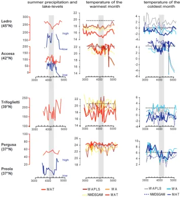
We also present evidence of a strong climatic change around 4200 cal BP (Figs. 7 and 8). Pollen-inferred cli-mate reconstructions from Lakes Ledro, Accesa and Pergusa
highlight a marked cooling event at ca. 4300–3800 cal BP, corresponding to declines in winter and summer
tempera-ture decrease of 2◦C (Fig. 8). This event, also seen in the
North Aegean Sea (Fig. 5d), is possibly the regional ex-pression of the so-called “4.2 kyr event” observed in vari-ous regions of the world (e.g. Geraga et al., 2010). In the southeastern Aegean Sea, the H index records a humid phase between 5400 and 4300 kyr that coincides with the deposi-tion of a distinct sapropel-like layer and that is interrupted at
∼4.2 cal kyr BP (Triantaphyllou et al., 2009b). Additionally,
some Italian sites south of 43◦N have shown temporary
mid-Holocene deforestation at 4000 cal yr BP that may have been caused by drought (Di Rita and Magri, 2009).
Magny et al. (2009) recognize a complex tripartite cli-matic oscillation between ca. 4300–3800 cal yr BP based on the Lake Accesa lake-level variations (Fig. 8). The three phases entail a phase characterized by dry conditions at ca. 4100–3950 cal yr BP that is bracketed by marked by wet con-ditions, dated to ca. 4300–4100 and 3950–3850 cal yr BP, respectively. Pollen-based summer precipitation reconstruc-tions for lakes Accesa, Ledro and Trifoglietti (Fig. 8) con-firm the presence of such a dry event and provide some in-sight into the possible complexity of this climatic oscilla-tion around the 4.2 kyr event. The 4.2 kyr event in the sub-tropical zone is a single short-lived event which may have corresponded to a climatic episode controlled from low lati-tudes (Marchant and Hooghiemstra, 2004) and can be asso-ciated with an expansion or northward displacement of the North African high-pressure zone. The dry episode centred at ca. 4150–3950 cal yr BP that is detected in Accesa, Ledro and Trifoglietti may be related to this short-lived dry phase, bracketed by two wet phases in the central Mediterranean.
4.4 Precipitation seasonality, proxy sensitivity and
climate reconstruction
Enhanced rainfall near Lake Accesa between ca. 8900 and 7300 cal yr BP has been interpreted from speleothems re-covered from Corchia Cave in the Apuan Alps (Zanchetta et al., 2007b) and from ca. 8200 to 7100 cal yr BP from Renella Cave, close to Corchia Cave (Zhornyak et al., 2011). The Renella record suggests that during the early to mid-Holocene, the region experienced very wet conditions asso-ciated to a substantial increase in flood activity (Zhornyak et al., 2011). However, during the first part of this period, the nearby lakes of Accesa and Fucino (e.g. Giraudi et al., 2011; Magny et al., 2007) experienced low-stand phases. Changes in precipitation seasonality may explain the appar-ent discrepancy between wetter conditions from speleothem records and drier conditions reported from lake-level recon-structions (Peyron et al., 2011; Magny et al., 2007, 2012b). This hypothesis is supported by the contrasting seasonal pat-terns of precipitation (strong Mediterranean conditions, with wet winters and dry summers) reconstructed for the early to
150 200 250 300
summer precipitation and lake-levels 0 50 100 150 200 20 40 60 80 100 100 150 200 250 3000 4000 Ledro (45°N) Accesa (42°N) Trifoglietti (39°N) Pergusa (37°N) Preola (37°N) temperature of the warmest month 14 16 18 20 22 14 16 18 20 22 14 16 18 20 22 18 20 22 24 26 -2 0 2 4 -6 -4 -2 0 2 4 3000 4000 5000 -4 -2 0 2 4 6 2 4 6 8 10 temperature of the coldest month W A P LS W A NMDSGAM M A T W A P LS W A NMDSGAM M A T -4 M A T 3000 4000 5000 3000 4000 5000 3000 4000 5000 3000 4000 5000 3000 4000 5000 5000 3000 4000 5000 3000 4000 5000 high low low high low
Fig. 8. Synthesis figure for the 4.2 kyr event in Italy, and comparison with lake-level data.
mid-Holocene at Accesa from pollen data (Fig. 4; Peyron et al., 2011).
In the current study, we emphasize changes in precipi-tation seasonality by examining them at the regional scale. A direct comparison of pollen-inferred summer precipita-tion and lake-level changes at Lakes Ledro and Accesa from north-central Italy is shown in Fig. 6. Mediterranean conditions only appear to exist at Lake Ledro prior to 8500 cal yr BP (Fig. 4). Mediterranean conditions terminate with increases for both summer and winter precipitation be-tween 8300 and 7000 cal yr BP. These results fit well with the relatively high lake levels at Ledro (Fig. 6), with the speleothem results from Corchia and Renella (Zanchetta et al., 2007b; Zhornyak et al., 2011), and with southern Alpine speleothems (Sp¨otl et al., 2010). Southern and east-ern Alpine speleothem records appear to register a humid period that is contemporaneous with the wettest phase iden-tified at Corchia (i.e. ca. 8000 to 7300 cal yr BP) (Sp¨otl et al., 2010). This humid period was interpreted as an increase in moisture sourced from the Mediterranean as opposed to the drier northwesterly air masses that affect the Alps (Sp¨otl et al., 2010). At Accesa winter precipitation is particularly high around 8000 cal yr BP (Fig. 4). High winter precipita-tion is consistent with the increase in flood activity due to increased storminess in the region suggested by Zhornyak et al. (2011), and is confirmed by a significant increase in
winter precipitation between ca. 9500 and 7000 cal yr BP in the northern Aegean Sea (Kotthoff et al., 2008, 2011).
Proxy records of precipitation from Sicily show higher rainfall between ca. 8500 and 7500 cal yr BP (Carburangeli Cave speleothems: Frisia et al., 2006; land snail shells, Fav-ignana Island: Colonese et al., 2011). Colonese et al. (2011) take the thermal limits controlling periods of snail activity into account to suggest that the increased precipitation at this time may not have been an exclusive winter phenomenon but may have extended into spring and autumn. The two south-ern sites reported in this current study (Trifoglietti, Pergusa) both show higher winter precipitation, which is corroborated by Colonese et al. (2011) and Frisia et al. (2006), provid-ing support that changes in seasonality may be major drivers for the high precipitation and lake levels at these sites from 10 000 to 6500 cal yr BP (Figs. 4 and 6).
The current study confirms that lake levels appear to be good indicators of summer precipitation changes (Magny et al., 2007) and supports the assumption that lake levels, pollen, and isotopic data likely reflect processes linked to seasonality. Possible discrepancies between data could be reconciled considering the relative sensitivity of each site to changes in the seasonality of precipitation (Giraudi et al., 2011; Peyron et al., 2011) and the different residence times of water in their respective hydrological systems, but fur-ther evidence is needed to improve the general framework of climate evolution at this time, both at local and regional (Mediterranean Basin) scales.
4.5 Climate processes and north–south partition
To fully understand the timings and the relationships be-tween regions and lakes within the Mediterranean Basin, we must understand the climatic mechanisms driving changes in moisture across the central Mediterranean during the Holocene. Tinner et al. (2009) have suggested that increasing humidity in coastal Sicily during the mid-Holocene reflects a decrease in the Hadley circulation (trade winds) and mon-soonal activity after the boreal insolation maximum. This is in agreement with processes suggested for other areas of the Mediterranean (Tzedakis et al., 2009). An intense African monsoon strengthens the Hadley circulation (Gaetani et al., 2007), reinforcing the North Atlantic anticyclone and its blocking effect for possible intrusions of humid western airflow towards the Mediterranean. However, recent obser-vations have also given evidence to possible influences of (1) sub-Saharan cyclones over the western-central Mediter-ranean (Knippertz and Wernli, 2010) and (2) rainstorms originating from the tropics over the eastern Mediterranean (Ziv et al., 2005). Moreover, Tzedakis (2007) and Tinner et al. (2009) have also pointed out the possible influence of local convective precipitation in response to the orbitally driven insolation maximum. The comparison of lake-level data and pollen-inferred estimates of climatic parameters along a north–south transect in the central Mediterranean