Development Under the Burden of Infrastructure:
The West Baltimore MARC Station Area Master Plan
by
Tamika Camille Gauvin
BA in Economics University of Chicago Chicago, IL (1998)
ARCH! fES
MASSACHUSErrS INSTITUTE OF TECHNOLOLGYSEP
2.6 2015
LIBRAR IES
Submitted to the Department of Urban Studies and Planningin partial fulfillment of the requirements for the degree of Master in City Planning
at the
MASSACHUSETTS INSTITUTE OF TECHNOLOGY September 2010
t[rebrut a
zo
20 C 2010 Tamika Camille Gauvin. All Rights ReservedThe author here by grants to MIT the permission to reproduce and to distribute publicly paper and electronic copies of the thesis document in whole or in part.
Author
Signature redacted
Dewrtment of Urban Studies and Planning August 11, 2010
___Signature redacted
Certified by ___________
Professor Brent D. Ryan Department of Urban Studies and Planning
Thesis Supervisor
Accepted
by_
Signature redacted
Professor Joseph Ferreira Chair, MCP Committee Department of Urban Studies and Planning
77 Massachusetts Avenue
Cambridge, MA 02139 http://Iibraries.mit.edu/ask
MITLibraries
DISCLAIMER NOTICE
Due to the condition of the original material, there are unavoidable flaws in this reproduction. We have made every effort possible to
provide you with the best copy available. Thank you.
Some pages in the original document contain text that runs off the edge of the page.
Development Under the Burden of Infrastructure:
The West Baltimore MARC Station Area Master Plan
by
Tamika Camille Gauvin
Submitted to the Department of Urban Studies and Planning on August 11, 2010 in partial fulfillment of the requirements
for the degree of Master in City Planning.
ABSTRACT
In the 1970s, approximately one thousand West Baltimore houses were razed and thousands of residents displaced to make way for what would have been 1-170, a highway that would have connected to 1-70 in Baltimore County to the Baltimore City Central Business District. After years of intense community opposition, the Highway was halted after a segment of the Highway ha d already been built.
Thirty years later, West Baltimore is the backdrop to another major public project. The Maryland Transit Administration (MTA) will redevelop the West Baltimore MARC station as a Transit-Oriented Development (TOD) via the West Baltimore MARC Station Area Master Plan for Transit-Centered Community Development (The Plan). This Plan could redirect investment into the severely disinvested areas in West Baltimore.
This research examines the intended results of the Plan to understand the realistic development opportunities for the West Baltimore MARC Station Area and the role that urban design and development could play in supporting or hampering the project's success potential.
I make suggestions that would improve the Plan's urban design and development approach to achieve better outcomes for community transformation. I recommend improved connections to existing community assets, minimal use of parking structures on prime Station Area blocks, using targeted economic development initiatives to create jobs for West Baltimore residents, a formal study for development scenarios for the Highway, and the creation of a project oversight group.
Thesis Supervisor: Brent D. Ryan
ACKNOWLEDGEMENTS
I express the deepest gratitude to Brent D. Ryan, my thesis advisor, for his guidance during this journey. Brent's combination of guidance and flexibility was exactly what I needed to do this research at this particular point in time. It was a pleasure to work with you.
I also thank my thesis readers Sam Bass Warner and P. Christopher Zegras, for their valuable feedback. It was great to sit down with you and Brent on the day of my thesis defense-your input gave me the confidence to move forward knowing that my research could be useful and valuable in the discussion on the West Baltimore MARC Station Area Master Plan.
Thank you to the representatives of Baltimore City-Department of Planning, Department of Transportation, Baltimore Housing and the Maryland Transit Administration, community organizations, and the development community who shared a wealth of information that helped to direct this thesis. I could not have done this without you.
I want to say a special thank you to Kirin Smith, Kate Edwards, Klaus Philipsen and Lorenzo Bryant. I called on you numerous times during my research and you were always gracious and helpful. Thank you.
To my dear friend Kristal Peters, I thank you for helping me over the finish line.
Finally, to my sisters Sonia and Carla, I love you. You have always been my support and you stepped up to the plate again when I needed you the most. And to my mother, words cannot express how much you mean to me. Thank you so much for your strength and wisdom. I love you
TABLE OF CONTENTS
Introduction
Plans and Precedents
Literature Review
Chapter 4 Urban Design and Development
Interviews Recommendations Bibliography Chapter 1 Chapter 2 Chapter 3 6 17 27 48 97 Chapter 5 Chapter 6 Appendix 104 115 118
CHAPTER 1: Introduction
Deja vu: Major Infrastructure Project Comes to West Baltimore.. .Again
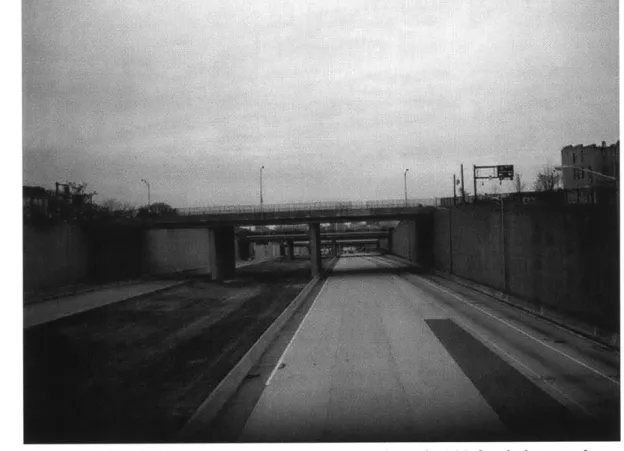
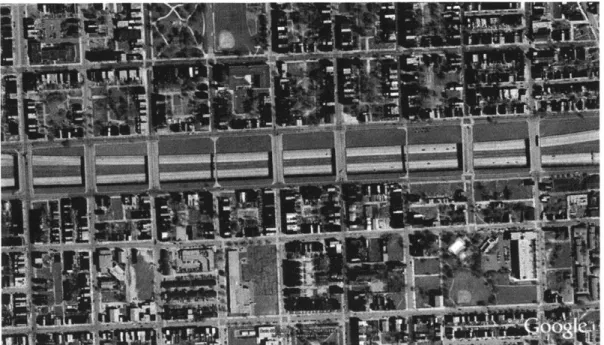
In the 1970s, approximately one thousand West Baltimore houses were razed and thousands of residents displaced to make way for what would have been 1-170, a highway that would have connected to 1-70 in Baltimore County to feed suburban residents into the Baltimore City Central Business District. This route is now known as Route 40 and more infamously as the "Highway to Nowhere"-a name that came into being when the highway project was halted leaving an approximately 1.5-mile unfinished segment of highway to bisect West Baltimore.
Thirty years later, the community is once again the focus of a major public investment plan. The West Baltimore MARC Station Area Master Plan-for "Transit-Centered Community Development" (The Plan)-is a long-range redevelopment plan issued in 2008 for the MARC commuter rail station area that includes West Baltimore communities adjacent to the station. The Plan is an important project for the City of Baltimore and the Maryland Transit Administration (MTA). For the City of Baltimore, it nrovides an opportunity to develop underutilized land, thereby increasing the tax base, it could potentially direct investment into some heavily disinvested West Baltimore communities, and makes West Baltimore the potential location for a major transit a MARC station and Red Line connection attracts new residents to the area.
The integral component of The Plan is the potential Red Line-a proposed surface light rail-connection to the MARC station. From this hub, West Baltimore residents would have direct transit access to major employment centers such as Washington, D.C., large employers to the west and east of Baltimore, and Aberdeen and Fort Meade, major locations for the Base Closure and Realignment Commission (BRAC) in Maryland. The ability of the West Baltimore MARC to stimulate housing development and job creation is very important to West Baltimore residents. The West Baltimore MARC Station Area Master Plan, which
incorporates the West Baltimore community's goals and principles for redevelopment, is not a plan for Transit-Oriented Development (TOD)-a compact, walkable mixed-use community centered on transit nodes-but for Transit-Centered Community Development, which supports the community's development needs and opportunities for current residents.
Can Transit-Oriented Development Transform West Baltimore?
Many state and local governments have begun to embrace TOD as one tool in a toolbox of neighborhood reinvestment and economic development strategies. TOD has shown its ability to transform struggling business districts and distressed communities into vibrant and desirable areas to live, work and socialize, however there are examples of Transit-Oriented Development that has fallen short of expectations. In some of these cases, the expected neighborhood revitalization never materialized and ridership might have fallen short of estimates. In short, TOD does not guarantee a successful outcome.
Then what does? What are the conditions for a successful Transit-Oriented Development? In the case of West Baltimore, can this Plan for Transit-Oriented Development catalyze housing development in neighborhoods where vacancies are extremely high, and where a paucity of basic services and lack of amenities make these communities undesirable places to live for most? Will TOD spark development interest in a place that has consistently been passed over for other areas in Baltimore that have been deemed more desirable development opportunities? How can the West Baltimore MARC Station TOD truly be community-oriented, serving the needs of the existing residents, while supporting amenities that would attract new residents? Finally, could the full realization of the vision in the West Baltimore MARC Station Area Master Plan be challenged by the urban design and development interventions in other projects, and in the Master Plan itself? These questions are the crux of this thesis.
The vision for a future West Baltimore, as it is presented in the West Baltimore MARC Station Area Master Plan, is one of tremendous transformation-a level of transformation that will require significant private and public investment. The problem is that there is little interest from private developers in the area, and the City and State might not be equipped to provide the financial investment and the political will required to mobilize private investment and see the project through. Furthermore, conditions specific to West Baltimore-high number of vacancies, crime, poverty levels and the eyesore of the Highway to Nowhere-the transit mode (a commuter rail) for this TOD, and the depressed development market (the overall lag in the market and its reluctance to go into West Baltimore) might challenge the fulfillment of the Plan's vision. If this were to happen, West Baltimore could miss a pivotal development opportunity-one that many residents feel is West Baltimore's last chance for revitalization in the form of housing development, employment opportunities, and establishment of businesses that provide basic services that the communities lack. Furthermore, if development (TOD) does not occur the communities would likely not attract new residents that could provide economic diversity and stability, thus leaving West Baltimore to
remain LII iL s.L %IJsII Lcurrent L %-aJ aL V1 LU eps1sst t Chag in1 a Xes UirCLU way aniu
perhaps over a more protracted timeline. This could be to the detriment of existing residents as vacancy spreads, additional neighbors leave in search of better neighborhoods, and the social problems typical of declining neighborhoods proliferate.
It is important, however, to note that West Baltimore comprises many communities, many of them extending beyond the West Baltimore MARC Station Area, and many of them with varying degrees of the aforementioned problematic conditions. As such, the description above should not be considered characteristic of all West Baltimore communities. To do this would be to ignore the unique qualities and conditions of each community, and the fact that there are other West Baltimore communities that lie outside of the station area. For example, vacancies are high in Harlem Park, but are few in Evergreen Lawn where the
neighborhood fabric is largely intact. At the same time, it is evident that much of West Baltimore is heavily disinvested, receiving very little development attention, while other areas in Baltimore, particularly in downtown, are development hotspots. In this regard, the West Baltimore MARC Station Area Master Plan could be an extraordinary opportunity to jumpstart a West Baltimore metamorphosis.
It is also imperative that consideration be given to the range of neighborhood changes that could occur as a result of the West Baltimore MARC Plan for TOD. This consideration was the point of departure for this thesis, as I was initially interested in understanding the chances that rapid gentrification would occur in West Baltimore as people were potentially attracted to the combination of new housing, retail, and employment opportunities that are the hallmark of Transit-Oriented Development. If rapid gentrification were to occur, the West Baltimore MARC TOD could work against existing residents as housing values increase rapidly and residents-particularly renters-relocate in search of affordable housing. My initial question was therefore, would the Plan for the West Baltimore MARC station spur rapid gentrification? In Chapter.Five, my research revealed that the probability of rapid gentrification was insignificant given conditions in the development market and in West Baltimore, and some elements of the Plan. Furthermore, some interviewees' comments hinted toward skepticism that development would happen. This led me to ask "Would developers be interested in West Baltimore"? I also wondered what developers would build in West Baltimore and how would the urban design and development recommendations in the Plan encourage or preclude the vision for the redeveloped West Baltimore MARC Station Area. These rudimentary thoughts were the impetus for the new direction in my research
Planning Is Not Predicting: What Could Happen in West Baltimore
What did I expect to learn in this research? The first point of departure for this study was TOD and its potential influence on rapid gentrification. What range of
neighborhood changes could occur in West Baltimore as a result of TOD at the MARC station? Could these potential changes cause a wave of gentrification that would force families-and particularly renting families to move out when housing prices rise? Furthermore, how is gentrification defined?
It is important to start with a definition of gentrification. The Merriam-Webster defines it as "the process of renewal and rebuilding accompanying the influx of middle-class or affluent people into deteriorating areas that often displaces poor residents." In his paper, "Two faces of gentrification: can zoning help"? Michael Davidson refers to the definition used in the 2001 Brookings Institution paper "Dealing with neighborhood change: a primer on gentrification and policy choices." The authors Maureen Kennedy and Paul Leonard define gentrification as "The processes by which higher-income residents of a neighborhood displace lower-income residents of a neighborhood, changing the essential character and flavor of a neighborhood." These definitions illustrate the polarizing nature of gentrification. Notions of the "us versus them" and "longtime-residents versus newcomers" underlie most discussions on the subject. This contention is not baseless. Many communities have experienced this sequence of events that places affordable housing out of their reach- The new housing built is expensive-think
high-end condominiums-and the rehabilitated housing becomes expensive after landlords renovate units to attract the incoming middle-class and affluent residents. Localities are not instituting inclusionary zoning regulations that require and/or incentivize affordable housing production as part of market-rate housing development projects. Yet, this is still not enough to mitigate the overall impact of gentrification in many communities, which experience an exodus of existing residents as housing becomes targeted at the more affluent classes.
In regards to the West Baltimore station area, it seemed plausible, that rapid gentrification would occur since TODs are highly desirable for their compact and walkable agglomerations of housing, retail and employment. The distinction between gentrification and rapid gentrification must be highlighted, as it was not my stance that any gentrification was undesirable, but that gentrification that
happened so quickly that a significant numbers of families would be adversely impacted was a problem. Of course, this begs the question, what is the right rate of gentrification and what is the appropriate holding pattern-or mix of races, income levels, families, etc., for a community? In the early stages of this research, when I interviewed city officials and organizations about the Master Plan, it became clear that gentrification- or rapid gentrification-while a consideration worth addressing proactively, was not the most pressing issue for the West Baltimore communities at this time. Nor was it a likely possibility according to developers I interviewed. Community organizations, and City and State officials involved in the master planning process, addressed and are still addressing this issue. Furthermore, the reality for West Baltimore-and this sentiment resonated in my interviews-was that some gentrification was necessary in order to break patterns of concentrated poverty, increase the tax base, and ultimately improve existing residents' access to services, housing, and employment opportunities.
With this realization, it also became clear that the success of TOD at the West Baltimore MARC Station could face an extraordinary set of challenges, namely overcoming the perception that West Baltimore is a group of impoverished and crime-ridden communities, and an inability to attract interest from the development community. A new set of questions arose. Would developers consider the West Baltimore MARC TOD a development opportunity and would they agree with the design and development recommendations in the Master Plan? What would developers say are realistic and good design and development interventions given market conditions in the Baltimore region and the physical conditions in West Baltimore? Finally, what type of development and design should be implemented at the West Baltimore TOD and what would be the key elements of these interventions? These were the guiding questions for my investigation, assessment of the neighborhoods, and subsequent urban design recommendations.
Research Methodology
The goals of this thesis were to:
" Gain an understanding of the range of neighborhood changes that could occur in West Baltimore as a result of the Plan for TOD. Is rapid gentrification an imminent threat to the communities in the West Baltimore Station Area?
" Assess the urban design and development recommendations in the West Baltimore MARC Station Area Master Plan and the implications of these recommendations.
" Gain an understanding of the development community's perception of the urban design and development recommendations in the Plan and its assessment of the West Baltimore MARC Station Areas as a development opportunity.
* Use the knowledge gained from these insights to recommend urban design and development strategies that will maximize development opportunities, while also remaining sensitive to the existing communities' needs and vision for the West Baltimore MARC Station.
To achieve these goals, I executed the research tasks outlined below. Along the way, some tasks were modified in response to information uncovered during the course of research.
Interviews
More than thirty interviews, with city and state agencies, area organizations, one community resident (more on this below), and area real estate developers were conducted. Interviews with key stakeholders such as City and State agencies, and area organizations provided significant insight on West Baltimore's planning history, the West Baltimore MARC master planning process, and precedents-or lack of-for TOD in Baltimore. These interviews revealed the injustice of past infrastructure projects such as the "Highway to Nowhere" and a host of later projects that failed to transform the deteriorated fabric of some communities. The
interviews also revealed the communities' general distrust of planning processes and projects, and how this distrust contributed to a tumultuous start to the West Baltimore MARC Station planning process.
Analysis of Precedents
An examination of the changes that occurred in Baltimore neighborhoods that are near existing transit lines would give some indication of what might happen in the West Baltimore Station Area as a result of TOD. This would be a direct comparison because the existing lines are rapid transit lines, while the MARC is a commuter rail system. These lines have different riderships and therefore, have different implications for development. Although not a centerpiece of the Plan, the proposed Red Line is a very important component-and likely the real strength of the Plan-and would be more comparable to the existing rail in Baltimore. It was revealed in the interviews City and State Officials that the neighborhoods located in rail transit corridors did not experience change. One take-away from this could be that the Red Line might not catalyze development in its corridor, however, to assume this would be premature. Whereas, the Red Line planning process was executed with an eye toward development, the planning for
the Metro and Light Rail lacked a development component.
Consequently, a robust analysis of possible neighborhood changes is not included in this thesis, however, a review of the literature on transit and its impact on property values gives some insight in the changes that experts have observed over the past few decades. Their observations serve as good indicators of the changes that could happen with the development of the existing West Baltimore MARC commuter station and the proposed Red Line.
Literature Review
An understanding of experts' consensus and points of debate on the impact of transit on communities would be useful for understanding the possible changes
particularly, the type of development and urban design patterns that might occur. The review in Chapter Three ranges from Alonso and Muth's (1964) seminal research on transit impact on urban settlement patterns to Cervero's contemporary research on the effect of transit on different types of real estate. Overall, the research shows that transit has an effect on where people choose to live and where businesses choose to locate, and that this effect is largely visible in property values. The research also shows that this influence is nuanced. For example, the effects-in the form of changes in property values-might be different for commuter rail versus light rail. In fact Cervero's 2003 study showed that the price premiums for housing near commuter rails were significantly lower than price premiums for housing near a light rail station. Furthermore, Kahn (2007), illustrated in his research that residential areas near Park and Ride stations had lower housing values and lower shares of college graduates than Walk and Ride stations. These theories could be applicable to the West Baltimore MARC Station Area, hinting toward less lower property values and presumably little developer interest. Furthermore, we see here that urban design interventions such as parking lots / structures could negatively affect the surrounding area. In the absence of precedents in Baltimore, the literature certainly provides some basis for understanding the changes that could happen in the West Baltimore MARC Station Area.
West Baltimore Station Area Contextual Review
A brief description of the West Baltimore Station Area planning and political history, and the area's demographic profile provides context to aid in understanding its current social, political and economic conditions. For example, the history of the Highway to Nowhere in West Baltimore is one of displacement, political unrest, and public investment. The Highway significantly altered the built environment in West Baltimore; understanding how this fracture in the fabric of West Baltimore impacted adjacent communities could lend some insight into the design interventions that could improve the quality of life there. Some of the historical context in this thesis comes from the interviews, as interviewees
usually mentioned the Highway to Nowhere and past projects when talking about present-day conditions in the Station Area.
The review in this section will be brief and will serve only to give some background to current events, as no planning or political action today is completely isolated from what happened yesterday. The planning process for the West Baltimore MARC TOD illustrated that a community's distrust could be rooted in planning and political transgressions that happened decades earlier. Furthermore, establishing trust, which was lost over years ago, could be a time-intensive and contentious, but necessary component of new projects.
Physical and Urban Design Analysis
Photo documentation is necessary to capture existing conditions in the communities. The field survey process could reveal assets to leverage and challenges to address, the way the community functions, and how residents use its public spaces. This is complemented with an analysis of the existing infrastructure, building, open space, and land use patterns to further reveal challenges and opportunities to improving development and urban design through the proposed West Baltimore MARC TOD. This analysis will also create a baseline for which to analyze the urban design and development recommendations in the West Baltimore MARC Station Area Master Plan, and to propose new or modified interventions that would enhance the urban design and development outcomes for the project and the communities in the Station Area. Ultimately, these improvements could provide an increased level of
specificity to the Plan, thereby increasing the marketability of the TOD and the ensuring that the communities' vision is realized as development occurs.
Hypothesis
The West Baltimore MARC Station Area Master Plan provides a framework to guide the West Baltimore Station Area toward revitalization. The West Baltimore MARC station will be at the center of this revitalization; Transit-Oriented
Development at the station will capitalize on the amenity in transit. The mix of housing, retail, and office space will bring new life into the Station Area and into the communities that have not had a major injection of investment since the Highway to Nowhere was built. The Plan evokes hope and excitement for a better West Baltimore, but is redevelopment as straight-forward as it is presented here? What are some of the issues that should be reconsidered?
I approached the Plan with skepticism, but my concern, at the time, was focused on the potential for rapid gentrification. I thought that the Plan would ultimately cause displacement in the Station Area communities. I quickly learned that rapid gentrification was not an immediate threat for the West Baltimore MARC Station Area because the area was so severely disinvestment that it would take time to attract development interest. Consequently, I turned my focus on understanding the development potential through the eyes of the developers and assessing the urban design and development recommended in the Plan to determine whether the Plan introduced any challenged to development or appropriately addressed the existing challenges to development in West Baltimore.
I hypothesized that the Plan would be questionable on three points: it was developed around a commuter rail station that has approximately 600 daily boardings, its placement of parking would challenge if not preclude development opportunities, it would not offer a solid solution for the Highway to Nowhere. Interviews with West Baltimore Station Area stakeholders and potential developers supported my concerns and provided a strong basis for the recommendations that I present in Chapter Six.
CHAPTER 2: Plans and Precedents
The West Baltimore MARC Station Area Master Plan
The West Baltimore MARC Station Area Master Plan for Transit-Centered Community Development is a strategy for community-guided Transit-Oriented Development at the West Baltimore MARC commuter rail station and the area within the Y-mile radius around the station. Between 2005 and 2008, West Baltimore residents collaborated with the Maryland Department of Transportation, the Maryland Transit Administration, the Baltimore City Department of Transportation, and a number of local organizations to create a community-minded vision for Transit-Oriented Development of the West Baltimore MARC Station and the communities that comprised the Station Area. The forty-year Plan, completed in 2008, reflects the State of Maryland's embrace of transit, and TOD as a planning and development tool to effectuate its smart growth policy and capitalize on existing transit investments. It also reflects Baltimore City's adoption of TOD as a tool to stimulate economic development and neighborhood reinvestment. These factors converged to create Transit-Oriented Development opportunities for the State, which had made significant investment in transit in previous years, and for Baltimore City, which had existing transit lines and wanted to strengthen its position as a regional business center, and spur community development in disinvested neighborhoods.
In 2004, after an analysis of potential strategic stations and subsequent negotiations, the Maryland Department of Planning (MDP) and the Maryland Department of Transportation (MDOT) designated the West Baltimore MARC Station as one of three promising pilot projects for the incorporation of Transit-Oriented Development principles in land use, policy and practice.' The promise for the West Baltimore MARC station is in its status as a link between Baltimore,
I Maryland, Baltimore City Department of Planning, Live-Learn-Pla-Earn: The City of Baltimore Comprehensive Master Plan (Baltimore: Baltimore City Planning
Washington, D.C. to the south, and Aberdeen and Fort Meade-potential job centers in the Base Realignment and Closure Act (BRAC)-to the north.
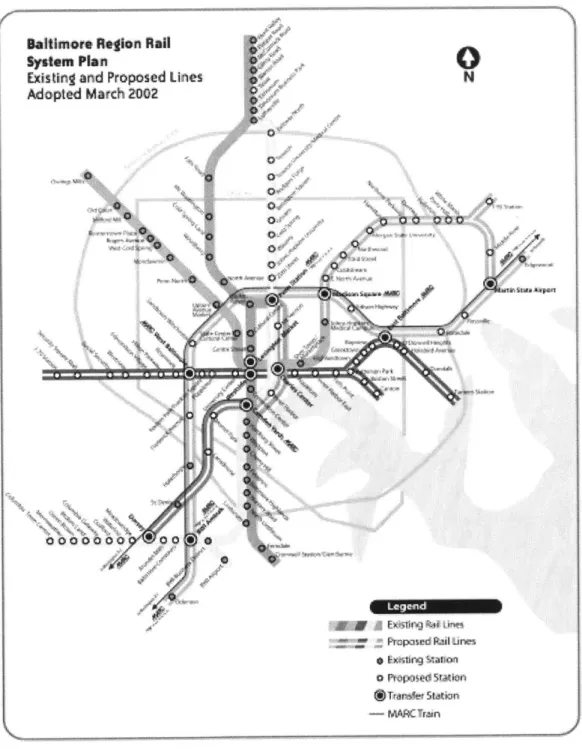
Additionally, the West Baltimore MARC station could become a transit hub if the Baltimore City Red Line, a proposed 14.5-mile east-west light rail with a stop at the West Baltimore MARC station, is built. The Red Line was designated as a priority project in the 2002 Baltimore Regional Rail System Plan, which outlined recommended rail construction and extensions that when complete, would make a comprehensive rail system.2 The Red Line is an integral component and a key
first step in the implementation of this plan because it would be the first east-west rail line in the City. The two existing rail lines-the Light Rail (called the Blue Line in the Rail System Plan) and the Metro (called the Green Line in the Rail System Plan) run in a northerly direction and do not connect (Figure 1).
Consequently, access to various parts of the City-and most notably the largest employers in the City-is extremely limited. The Red Line will be a significant step toward solving this problem. The proposed Red Line will traverse the heart of West Baltimore, connecting at the MARC station and will link riders to major employers to the east and west of the City in Baltimore County, and to downtown in the Central Business District (CBD). The Plan acknowledges the potential construction of the Red Line, but in it, no design recommendations are based on the existence of the proposed light rail. The Plan focuses on the TOD potential at the MARC station, outlining potential sites for development and recommended design guidelines, uses, and typologies that would best enhance development impact. A unique feature of the Plan is its incorporation of the residents' requests for services and guiding principles on housing, economic development, and transportation, so as to create a framework for development that is sensitive to the
2 Maryland, Maryland Transit Administration, Baltimore Region Rail System Plan
existing communities.3 Hence, the Plan is a framework for Transit-Centered
Community Development.
Sy
Ex
At
ltimors Rflion Rail
stem Plan
isting and Proposed Lines N
opted Match 2002 0" Oele A V, a 0 0 0 00 Q 0 0 X7 NAPrqpsad Rlines * Ns4Ing $htan 0 N"pS ed SiMA" *vfeStation - MARCTran
Figure 1. Baltimore Regional Rail System Plan
3 Maryland, Baltimore City Department of Planning, West Baltimore MARC Station Area Master Plan (Baltimore, 2006) 29-37.
The West Baltimore Community
Similar to many rust belt cities, Baltimore experienced a sizable decline in its population-a drop from 950,000 to roughly 640,000 between 1950 and the time of the 2000 Census-as the manufacturing industry declined in the United States. West Baltimore, in conjunction with this city-wide contraction, has suffered from significant disinvestment over the last four-to-five decades. Furthermore, West Baltimore suffered a serious blow during the 1960s and 1970s when several hundred houses were cleared and thousands of residents displaced to make way for 1-170, an east-west highway that would bring commuters from the West suburbs into the downtown Central Business District. At the time, this highway plan was considered a solution for reversing the decline in the CBD. Moreover, it was one of a number of plans for highways that would cut through neighborhoods to enter the downtown. Consequently, major citizen opposition marked the 1960s and 1970s. Yet, by the time citizens succeeded in halting these projects, nearly
1.5 miles of the Franklin-Mulberry corridor was cleared and a segment of the
east-west expressway was built. The expressway known infamously as the "Highway to Nowhere" was not completed. The highway segment built, incomplete and ending abruptly, remains in West Baltimore today. The disinvestment that precipitated some of the West Baltimore communities is linked to this relic of urban renewal and highway policies of the 1950 and 1960s. This is the legacy of West Baltimore and it is a memory that remains brandished on the memories of many of its residents. As a result a distrust of public projects looms in the communities. For example, one interview said, "There has been a lot of trust building along the Red Line Corridor."
Communities in the West Baltimore MARC Station Area
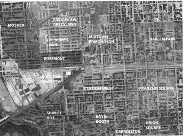
Today, many communities in West Baltimore show signs of decades of disinvestment, however, there also exists a number of stable communities. Ten communities lie within a V2-mile radius of the MARC station area. These neighborhoods include Rosemont Homeowners/Tenants, Evergreen Lawn, Midtown Edmondson, Station West (Penrose), and portions of
Bridgeview/Greenlawn, Harlem Park, Franklin Square, Boyd-Booth, and Shipley Hill (Figure 2).
Figure 2. West Baltimore MARC Station Area.
Source: West Baltimore MARC Station Area Master Plan.
The demographic information for these neighborhoods hints to some of the social challenges in this part of Baltimore. According to the West Baltimore MARC Plan, the 2000 Census data shows that 25,000 people, in 9,217 households, live in the ten neighborhoods. According to recent data, the number of vacant housing units in the station area is estimated at 1,250, with vacant lots estimated at 400. As of 2,000, 45% of housing in the station area was owner-occupied, while 55% was renter-occupied-some neighborhoods having higher homeowner-renter ratios than others. For example, Boyd-Booth, Franklin Square and Harlem Park/Lafayette Square had at 70% renter-occupied housing stock, while Evergreen and Rosemont-more stable neighborhoods-had 23%. Median household income for the area in 1999 was $23,500, which was below the City's median income of $30,000. Furthermore, approximately 30% of West Baltimore
residents had below poverty status, which was higher than the City's 23%. Neighborhoods in West Baltimore generally have higher proportion of families when compared to other areas in the City. Over 30% of the neighborhood population comprised residents age 19 and younger.
The Baltimore Neighborhood Indicators Alliance (BNIA), which tracks the performance of community statistical areas on a number of indicators, provides information on communities' Travel Time to Work in 2000-also based on Census Data. Generally, the data shows that the West Baltimore communities in the MARC station area spend more time traveling to work and that a greater percentage of these communities use public transportation when compared to other neighborhoods. This is an important fact about the ten communities because one of the goals for TOD-from the State and City perspective-is to connect residents to job opportunities in the region and to do so using a fast and reliable form of transit such as the Red Line light rail. Another indicator of note is that described as "Job-ready, working adults who continue to gain skills." Once again the data (based on the 2000 Census) on the ten communities indicate the ten communities are challenged. For example, the Greater Rosemont area, which
includes the Evergreen Lawn, Midtown Edmondson, Mosher, and Rosemont communities, had one of the highest unemployment rates at 18%. It is necessary to say that this is 2000 data and the picture might be very different today. However, given the current economic environment, which is similar if not more severe than the market decline in 2000, the unemployment rates for the Greater Rosemont area and the ten communities might once again exhibit greater severity when compared to other Baltimore neighborhoods. This is also an important fact in the context of the Plan for TOD, as one goal one of the Plan is to provide more job opportunities for low-skilled workers such as those that generally live in the
IN 0 WWI (ERB mow C3 to ... -/ ... ... ... . ... ... ... ... . ... ... ... I ... ... .... ... ....
L the proposed Red Line Light Rail Corridor highlighted in Red.
Transit-Oriented Development: A State and Local Development Strategy
The development influences in the West Baltimore MARC Station Area extend from a confluence of planning efforts and the plans that came out of these efforts. This confluence of influences results from a planning climate in which transportation is an integral component in strategies to advance State and Local economic and community development goals. Transit and Transit-Oriented Development (TOD) are viewed as a means for connecting residents to employment opportunities, attracting new residents and businesses to the Baltimore region, and increasing transit ridership. Baltimore City has a particular interest in realizing these goals. As of 2000, the City experienced a 30% population decline from its peak population of 950,000 in the 1950s.4 Consequently, Baltimore has experienced a substantial decrease in tax revenues collected and has had to fill the gap by implementing a property tax rate, which is at least twice the rate of surrounding counties. Also, Baltimore City's share of regional jobs is declining compared to that of its suburban counterparts.5 Transit
and Transit-Oriented Development are woven into the strategies that the State of Maryland and Baltimore City have developed to address these issues.
The State and the City's interest in leveraging Transit-Oriented Development for economic and community development is visible in the plans developed within the last decade. Two plans, in conjunction with the West Baltimore MARC Station Area Master Plan (2008), have set the tone for Transit-Oriented Development in the Baltimore region and for development in the West Baltimore MARC Station Area. The transit investments proposed in the Baltimore Regional Rail System Plan are subsequently leveraged in the City of Baltimore Comprehensive Master Plan (CMP) and the West Baltimore MARC Station Area Master Plan to drive economic development and neighborhood reinvestment through strategic Transit-Oriented Development.
4 Central Maryland Transportation Alliance, "Central Maryland TOD Strategy: A Regional Plan for Transit-Centered Communities", 2009, ES1.
The Plans
Baltimore Regional Rail System Plan (2002)
In September 2001, the Maryland Department of Transportation (MDOT) assembled a 23-member Advisory Committee to develop a long-term Regional Rail System Plan (Rail Plan) and make recommendations on priority projects for the Rail Plan. In August 2002, the Advisory Committee, which comprised elected, civic, business, transit, and community leaders, published the Baltimore Regional Rail System Plan. The objectives of the Plan include establishing a true system of rail lines between major life activity centers, serving areas with the greatest concentration of population and employment, and making the most of prior transportation investments. In the 19-page document, the Committee recommended new rail lines and rail extensions that when completed would give the Baltimore region a comprehensive rail system. The completed system, which will take forty years to build and consist of 109 miles of track, 122 stations and six lines, will be an important step in meeting the Rail Plan objectives.
Live.EarnePlaysLearn: Baltimore City's Comprehensive Master Plan 2007-2012 (2006)
LiveoEamePlayeLearn, the City of Baltimore Comprehensive Master Plan (CMP) was completed in 2006. LiveeEarnPlayeLearn added an implementation strategy for the goals that were outlined in the City's 1999 PlanBaltimore. PlanBaltimore was the culmination of a planning process that began in 1997 as an attempt to update Baltimore's thirty-year-old comprehensive plan. The Executive Summary of Live*EamePlayeLeam states "while the draft was greatly enhanced, it primarily provided policy recommendations instead of concise goals and strategies to move the City of Baltimore forward." As the title suggests, Live*EamePlayeLeam takes a comprehensive look at the key aspects of Baltimoreans' lives, with the goal of laying a foundation for constituents' achievement of a quality life in Baltimore.
The Baltimore Regional Rail System Plan had been in place for two years when the planning process for Live.EamPlay*Leam began in 2004. The Rail Plan, and another State policy, the Smart Growth Act of 1997 might have set the stage for Baltimore's connection of CMP goals, objectives and strategies to transit and Transit-Oriented Development, and to the general State and City recognition of West Baltimore as a critical TOD priority. The Smart Growth Act is a set of policies and programs to support and revitalize existing communities, with the
goal of directing State infrastructure toward areas with infrastructure in place and away from infrastructure for sprawl development. Its influence, and the influence of the Rail Plan are evident in Live.EamPlayeLeam, in which transit and TOD principles are threaded throughout the Plan. A look at some of the CMP goals and strategies exhibit links between transit and TOD, and the goals, objectives and strategies that will move the City's Master Plan forward. For example, to achieve its goal of improving access to jobs and transportation linkages, the City set as an objective enhancement of transportation options to provide workers with commuting options and mitigation of traffic congestion. The City will meet this objective by supporting efforts to implement the Baltimore Regional Rail System
Dn nd 4ts dpT ;ine ndA Gr T epirt segments. The constru1ct4-1n of the
Red Line, could greatly benefit West Baltimore residents, who generally have the longest commute times to work and rely more on public transit to get to work when compared with residents in other Baltimore communities.
The CMP also details the measures that must be taken to create a development climate that could support and encourage TOD. Zoning is a significant issue that was highlighted through the creation of the Plan. The current code does not support mixed uses, which is usually a defining characteristic of TOD and usually increases the success of such projects. The City has a launched a review and rewrite of the existing code. This initiative is called Transform Baltimore. Mixed-use zoning and Transit-Oriented Districts and Overlays will be included in the new zoning code, which is currently in a draft review phase and open to the
CHAPTER 3: Literature Review
Many states and municipalities are adopting Transit-Oriented Development (TOD) as a strategy for the redevelopment of underutilized land and disinvested communities along existing and new transit nodes. Many governments believe that these areas can be turned around through the type of redevelopment that makes transit nodes active centers. TOD, by definition, creates this desired activity through a mix of uses-typically residential, retail, and office-in a compact and pedestrian-friendly environment. Just as governments have recognized the merits, so too has the public realized the benefits of living, working, and recreating in locations set in a walkable and transit-connected urban fabric. Reaction to volatile gas prices, traffic congestion, and environmental degradation-as well as an overall draw to the cultural amenities of the city-has led many who would have typically chosen to live in the suburbs to opt for city living. Given the growing demand for Transit-Oriented Development, it is plausible that land values and housing prices in transit areas would be driven up. Many research findings suggest that this phenomenon does indeed occur. This could have significant implications for TOD in inner-city communities where low-income and working-class families live in large concentrations (Glaeser, Kahn and Rappaport 2007). Gentrification of once distressed neighborhoods could occur as housing in the station area becomes more expensive and out of reach to the existing residents in inner-city communities. One might ask, "Does TOD cause gentrification?" In the case of West Baltimore, is there a significant probability that gentrification would occur as a result of the plan for Transit-Oriented Development at the West Baltimore MARC Station?
In this chapter I provide a framework for answering these questions through a literature review on Transit-Oriented Development Gentrification-as a phenomenon. There is an extensive body of literature on gentrification and a similarly extensive body of literature on TOD and its influence on residential property values and land values in communities adjacent to transit. Such literature-on property values in transit areas-makes a significant contribution
to the theory of TOD and gentrification as the rise in property values can be used as a proxy for gentrification. Gentrification entails a number of phenomena, i.e., conversions from renter-occupied to owner housing, changes in race, socioeconomic characteristics, and increases in property values (Lin 2002). A large portion of the literature on TOD and gentrification-as a phenomenon-explore the relationship between changes in property values and the extension or opening of a rail transit line. Many of the theories presented here are of this genre, however, each one offer a different perspective and raises different questions about the link between transit and gentrification. The second section of the review focus on this body of literature; the first section focuses on transportation and residential spatial patterns; the third section focuses on obstacles to Transit-Oriented Development in the inner city; and the fourth section focuses on gentrification, as a broader topic, sans the connection to transit.
Transportation and Residential Spatial Patterns
In "Why do the poor live in cities? The role of public transportation" (Glaeser et al. 2007), Glaeser et al. provides evidence for their hypothesis that poor people concentrate in the city due to abundance of transit in these locales. Their point of departure, similar to other theories on TOD and gentrification, is one of the earliest theories to link residential spatial patterns and transportation-the Alonso-Muth theory of centralization (Alonso 1964 and Muth 1969). The theory states that the rich would choose to live further away from the city center because they prefer more land, which is cheaper away from the city center. The rich exercises this spatial preference despite the fact that they value time more highly than the poor and should choose to live at the city center to minimize their commute times. In this case, the income elasticity demand for housing for the rich exceeds their income elasticity demand for commute time (Figure 4).
r
Figure 4. Bid-rent scenario.
Glaeser et. al does not base their theory on the Alonso-Muth model because the latter assumes a monocentric city and income elasticity demand less than one. Interestingly, Wheaton also rejected the Alonso-Muth model on the account of his own findings that neither the rich nor the poor had a comparative advantage in a particular location (Wheaton 1977). He concluded that the Alonso-Muth model was not robust enough to explain residential patterns in American cities. Drawing a similar conclusion, Glaeser et. al opted to base their work on LeRoy and Sonstelie's theory, which also explored the link between transportation and residential patterns. LeRoy and Sonstelie's theory represents a pivotal moment in the development of the theory of urban form and transportation and thus requires
some discussion.
In "Paradise Lost and Regained: Transportation Innovation, Income and Residential Location," LeRoy and Sonstelie extend the Alonso-Muth Model to include two modes of transportation instead of one. This model is considered more applicable to the American pattern of settlement, particularly as it relates to the effects of a new transit technology on the settlement pattern of the poor and the affluent. The formation of the streetcar suburbs and the solidification of the
suburbs through the introduction of the car are reminiscent of the LeRoy and Sonstelie theory. In their model a new transit technology is very expensive-even for the rich-when it is initially introduced to the public. A very small segment of the population moves away from the city center, but still most of the poor and the rich remain in the city. LeRoy and Sonstelie call this the Paradise period. As the technology becomes more affordable, the rich use it-and move away from the city to the suburbs-but the technology is still too expensive for the poor. The poor, which have a higher income elasticity demand for housing than for time, would stay in the city center and spend more time to get to work using the cheaper mode of transportation. The rich, who attach a greater cost to commute time, move to the suburbs and commute to work quickly using the new technology. Consequently, the poor become concentrated in the city and most of the rich will live in the suburbs. History has shown the multiplicity of social problems that result when poverty is concentrated. This is the period that LeRoy and Sonstelie call Paradise Lost. As the cost of the new transit technology declines further, it becomes attainable to the poor. As a result some of the poor also move to the suburbs to get more housing at lower prices, while minimizing commute costs with the use of the new technology. The rich might start to move back into the city-perhaps to avoid the poor or to once again take advantage of cheaper rents. The authors call this regentrification or Paradise Regained. These results confirm Wheatons's finding that when both rich and poor commute by car, as in 1970 and 1977 the bid-rent function of each are very close. No one group has a strong comparative advantage in either suburban or downtown locations.
Glaeser et. al take their queue from LeRoy and Sonstelie's research, which makes a direct connection between public transportation and the urbanization of the poor. They argue that the primary reason for central city poverty is public transportation. Through analyses of the income-distance (distance to rail transit lines) relationships for older and new cities, and urban poverty rates by demographic groups, Glaeser et al find support for their theory that the poor centralize in the cities due to access to public transportation. The results of their
analysis show that public transportation usage appears to strongly predict poverty and to explain a substantial amount of the link between access to proximity to transit and poverty (Glaeser et al 2006). They also analyze data for areas where the car is the only transit mode and find that in these areas, the rich live closer to the city center, concluding that the existence of multiple modes of transportation is integral to understanding why the poor centralize in cities. In one more test, Glaeser et al examine the effects of subways in metropolitan areas. Analyzing income in subway and non-subway cities they find that income first declines with respect to the distance from the Central Business District (CBD), out to three miles, for subway cities such as Boston, Chicago and New York City. Income increases with distance over three miles to the CBD. Oppositely, in non-subway cities, income rises with distances within three miles to the CBD. Moreover, public transit usage decline-as income increases-with distances beyond three miles from the CBD in subway cities. This finding picks up on the shift from public transit to car usage by the rich-an idea that is a key tenet of LeRoy and
Sonstelie's theory.
The theories presented in this body of literature provides a good framework for understanding how access to transit might have influenced the residential patterns in West Baltimore and how Transit-Oriented Development-in the form of a "new transit technology"-might catalyze a population shift. In this scenario, the affluent would move closer to the city center-to areas like West Baltimore. This phenomenon would be consistent with LeRoy and Sonstelie's "regentrification" or "Paradise Regained" scenario and Glaeser et al's subway cities, where the rich return and live closer to the city center. Based on these theories, West Baltimore could experience gentrification as a result of the West Baltimore MARC Station Area Plan for Transit-Oriented Development.
Transit Impact on Property Values
A number of social, economic, demographic, and other changes and shifts might occur in a neighborhood undergoing gentrification. Changes in property values
are used most as indicators of these changes in the literature on Transit-Oriented Development and gentrification. In this research, I focus on changes in residential property values, as it is property values that directly influence individuals' housing choices and the larger patterns of urban settlement. Many studies have been done on the impact of transit on proximate residential property values and most of these studies show some form of price premium for such properties. However, the study results vary in the extent of the premium and reveal that this variation could be the result of a number of external factors, such as station effects, station design, demographics, etc. These variations highlight the uniqueness of each city and neighborhood context, and that it is often a confluence of factors that make the benefit of transit access capitalized in housing prices.
Many have looked at the relationship between housing price and proximity to a transit stop. McMillen and McDonald (2004) examined the reaction of house prices to a new rapid transit line between downtown Chicago and the Midway Airport. Their study focused on the years 1983-1999, the periods before and after Lllt eLLI% VVe wa LJtLL. Uing'1L 11%4 '%,F.I(L 0n"d p s IaILes metLds, McViA.1VLLL CLlnan
McDonald provide empirical evidence that the transit line opening, which happened in 1993, had been anticipated and that house prices with respect to distance declined further away from the transit station-a negative house price gradient. Their study revealed a negative gradient (-10% to -15% per mile) after the opening of the Midway Line in 1993 compared to the initial gradient in 1983, which was significantly less negative. These results were based on analysis of price indices for repeat sales. An analysis using a hedonic method supported these results: there was a price gradient of -4.2% in the initial period 1983 to 1986, -7.4% between 1987 and 1990, -15.2% in 1991-1996, and finally, -5.6% between 1997 and 1999. McMillen and McDonald's results also showed that home prices increased substantially as a result of the new transit line. Using 1986 as their base, they found that appreciation rates were approximately 6.89
percentage points higher between 1986 and 1999 than comparable homes farther from the nearest train station.
Two years earlier Lin (2002) also used housing market activity as a basis for studying transit and gentrification in Chicago. Lin, however, is not only interested in difference in property values, but also in the difference in property value growth rates. He focuses his research on the north and northwest sections of Chicago during the period 1975 and 1991, first examining the role of gentrification in these parts of the City. He also explores whether gentrification behaved like a wave, moving out from the CBD and Lake Michigan. Lin acknowledges that it is widely accepted that transit service creates a premium on property value, but also says that most studies prior to his did not examine the rate at which property values increase. He also acknowledges that the CBD and Lake Michigan are two geographic features that would have a strong influence on gentrification patterns. Urban professionals, he says, would move close to the CBD and that the lakeshore on the north has steadily been a magnet for the affluent. Lin expects that property value growth rates for areas close to transit stations would exceed those at areas farther from transit stations. The results seem to support his hypothesis. Lin charted the percentage change of property values as a function of distances from the lake, the CBD, and transit stations. Through regressions and charting of percent change in property value on residential density, and distance to the CBD, Lake Michigan and transit the relationships between gentrification and transit and the rate of property value growth and transit are clearly illustrated. Overall, the greatest rates of growth are closer to the transit stations. Similarly, the greatest rates of growth are at the CBD. For example the percentage change in property value between 1985 and 1991 was approximately 130% for areas approximately .25 mile, 120% for areas
.5 mile away from a transit station, and 100% for area one mile away from the
from a transit station. Results for Lake Michigan during the same period, however, show a slightly different pattern-the percent change in property value increases with distance from the lake, peaking at 125% at 1.4 miles from the lake,
decreasing to approximately 90% at 3.25 miles from the lake, and then increasing again with distance from the lake. It should be mentioned that Chicago was experience an explosive growth cycle between 1985 and 1991. The change rates for the periods 1975-1980 and 1980-1985 are significantly lower, however, this does not in any way negate the findings.
Bowes and Ihlanfeldt (2007) look at the negative externalities that can counter the positive effects of transit on property values. The authors state that no study has fully investigated the underlying factors that may account for the effect of proximity to transit on property values. Accordingly, they sort out these effects with the use of a hedonic price model and auxiliary models for neighborhood crime and retail activity. From the outset they posit that access to a rail station is a positive factor and that most studies confirm this, however, the compendium of literature presents mixed results. Bowes and Ihlandfeldt point out Gatzlaff and Smith's (1993) study, which found that the Miami Metrorail had no significant effects on property values. In fact, in the time period covered by the Metrorail study, there was no significant neighborhood revitalization along the northern edge of the system. Policymakers in Miami believed that the Metrorail would be
a catalyst for revitalization in the northern section, which was experiencing economic decline. Bowes and Ihlanfeldt's study probes more deeply into issues such as these. What underlying factors influence property values such that they negate the positive effects of access to transit? The authors examine the effects of crime, retail, and proximity to the transit station in a hedonic model, and crime and retail auxiliary models and apply the combined results to calculate the price effects of a MARTA station in Atlanta. Bowes and Ihlandfeldt's three main conclusions were that direct effects are generally larger in absolute value than crime or retail effects, retail effects are larger than crime effects (except in the immediate vicinity of stations located close to downtown, and that total effects vary a great deal with neighborhood income level, distance to downtown, and distance from the station. In regards to the last conclusion, the largest positive total effect tends to occur at the farthest distance from the CBD between
one-quarter to one-half mile of a station. The largest negative effects are found in high-income neighborhoods within one-quarter mile of a station especially if the station is located close to a parking lot. The authors attribute this to crime and externality effects. This study serves to highlight some of the nuances of the transit access benefit-proximity to transit might positively affect housing prices, but there are additional factors that also influence the overall price effect.
Kahn (2007) illustrates such nuances. Studying fourteen transit-oriented communities, Kahn finds that communities where "Walk and Ride" stations were built experienced greater gentrification than those where "Park and Ride" facilities were built in the same metropolitan area. His evidence showed home prices increasing by 3% for census tracts that had median incomes below the metropolitan median and were "treated" with a Walk and Ride station. Census tracts that were "treated" with a Park and Ride experienced no change in home prices. These figures represent averages for the fourteen cities; looking at the cities individually revealed significant differences. For example, he states that the average tracts treated with Park and Ride stations in Boston experienced a 5% decline in home prices. Average home prices in Baltimore-Baltimore is one of the fourteen cities Kahn studied-did not decline, however increases in home prices were weaker for Park and Ride station areas. Home prices near Park and Ride areas increased by 6.5% versus 16.7% at Walk and Ride areas. Kahn also found that the share of college graduates residing near Park and Ride stations relative to control tracts-census tracts in the same metropolitan area with similar observable characteristics and have not experienced increased proximity to rail-was higher. Using the share of college students as a second indicator of gentrification, Kahn reports that nine of the cities with communities treated with Walk and Ride stations experienced a positive and statistically significant increase in the share of adults who are college graduates. In eight of the cities, communities where Park and Ride stations were built experienced a significant reduction in the share of adults who are college graduates.