HAL Id: hal-01184208
https://hal.archives-ouvertes.fr/hal-01184208
Submitted on 13 Aug 2015
HAL is a multi-disciplinary open access
archive for the deposit and dissemination of
sci-entific research documents, whether they are
pub-lished or not. The documents may come from
teaching and research institutions in France or
abroad, or from public or private research centers.
L’archive ouverte pluridisciplinaire HAL, est
destinée au dépôt et à la diffusion de documents
scientifiques de niveau recherche, publiés ou non,
émanant des établissements d’enseignement et de
recherche français ou étrangers, des laboratoires
publics ou privés.
To cite this version:
Pierre Benoit, Jean-Marie Grisoni, Mustapha Meghraoui. Quaternary faulting in the central Paris
basin: Evidence for coseismic rupture and liquefaction. Seismic hazard, critical facilities and slow
active faults., Oct 2013, Aachen, Germany. pp.ISBN: 978-3-00-042796-1. �hal-01184208�
Quaternary faulting in the central Paris basin: Evidence for coseismic rupture and
liquefaction.
Pierre Benoit (1), Jean Marie Grisoni (2) and Mustapha Meghraoui (3)
(1). Laboratoire Aquanalyse, 10380 Plancy-l’Abbaye, France : pierre.benoit@wanadoo.fr
(2).Université Paris 8, Département de Géographie, bâtiment D, 2 rue de la liberté, 93256 Saint-Denis Cedex, France (3). Institut de Physique du Globe, UMR 7516, 5 rue René Descartes, 67084 Strasbourg, France
Abstract:We describe new evidence of Quaternary faulting observable in large outcrop exposures (trenches and carries) near Romilly-sur-Seine in the centre of Paris basin. Coeval normal or reverse faults affect sand, marl and gravel units that also expose liquefaction features. Quaternary units with thicknesses ranging from decimetre to metre are sealed by non-deformed deposits. The coexistence of soft and brittle tectonics with ~1 m vertical offset in a single cross-section, affecting different stratigraphic levels, reflects their diachronic nature and attest for their coseismic origin. The faulting of young deposits visible in the paleoseismic sites belong to the major regional tectonic structures, i.e. the Omey and Vittel fault system that affects the late Quaternary units of the east Paris basin. Their activity known locally as Ypresian polyphased seismites, seems to have continued until the late Quaternary. The Quaternary ruptures and coseismic nature of the fault system call for a realistic seismic hazard assessment in this intraplate tectonic environment.
Key words: active faulting, liquefaction, Quaternary, Paris basin INTRODUCTION
Intraplate Europe experienced large to moderate earthquakes (Mw > 6.0) inducing surface ruptures and liquefaction accompanied by severe damage to buildings and significant numbers of victims (Camelbeeck and Meghraoui, 1998). The coseismic indicators of tectonic activity in intraplate continental regions may rapidly disappear when the time interval between major
earthquakes is often larger than 10,000 years.
Paleoseismology in regions of low-level active deformation indicates, however, that return period of large earthquakes may reach 50 à to 100 ka (Meghraoui et Crone, 2001). The existence of coeval soft and brittle tectonics in lacustrine or fluvial Quaternary deposits constitutes unequivocal paleoseismic features that document past earthquake activity.
In this work, the detailed description of the active tectonics affecting the Paris basin is presented with evidence of thrust and normal faulting systems that rules out periglacial influence or lateral spreading. The existence of active faulting in both the bedrock and Quaternary units in a single site attests for the coseismic origin of the active deformation and points out the seismic hazard reevaluation.
REGIONAL TECTONIC SETTING
The tectonic activity in the Paris basin during the Cenezoïc period has long been documented and shown in published geological sheets. Indicators of seismites (mainly sand blows) in the Ypresian have been observed on the outskirts of Romilly-sur-Seine, in the edge of the Ile de France cuesta (Plaziat, oral communication). Although, an intense past seismic activity has been described in the Fontainebleau and Bartonian sands, no causative faults were studied and
properly described with their characteristics (Plaziat, 2009). The Quaternary tectonic episodes affect mainly the alluvial and lacustrine deposits but some periglacial features may appear sporadically in outcrops (Michel, 1972; Antoine, 2005).
The regional stress distribution from Pliocene to present shows an average N160 σ1 obtained from the study of fault
kinematics (striations) in the east Paris basin (Grégoire, 2003). The more pronounced active tectonic deformation has been identified in seismic profiles (obtained from commercial sections of oil research) around major faults that cross stratigraphic units deemed to be Quaternary. In parallel, both instrumental and historical seismic activity in the region is shown to be low but not negligible (Sisfrance, 2013)
Fig. 1: Morphotectonic map with main Quaternary Vittel and Omey faults (bold line) as mapped in the field (Institut Français du Pétrole, 2000, and” Geological map Fère champenoise 1/50000”). Yellow square with number are sites with paleoseismic features (as in text) : 1 – Gourgançon, 2 – Longueville, 3 – Clesles, 4 – Sauvage. According to the regional stress distribution and N150 direction of σ1 (Grégoire, 2003), fault kinematics indicate a main reverse component. One may
note the influence of the Omey and Vittel Fault and related NW block uplift on the Seine River deflection.
QUATERNARY SEDIMENTATION
The studied region shows Mesozoïc (chalk) outcrops
unconformably covered by Quaternary deposits
(geological map Paris 1/250000). During the late Quaternary and in a periglacial environment and climate, the region was subject to cryoturbation and large solifluction (mudslides). A thin loess cover occupies some depressions and a large volume of gravel and limestone sand produced by glacial alteration are visible in the great valleys of the Aube and Seine. However, the relatively large distance to the sea did not allow for a significant deepening of the valleys during glacial episodes. The Holocene units made of fine alluvial deposits cover gravel and sandy formations.
DEFORMATIONS AFFECTING THE QUATERNARY
The first descriptions of tectonic features and brittle
deformations were carried out by Coulon (1994) and subsequently by Baize et al. (2007). The former author attributes them to seismic episodes associated with the final volcanic activity in the Massif Central. Most of outcrops are in quarries and while the latter authors refer to possible gravitational sliding on the permafrost, the possible seismic origin of the tectonic features were proposed by Benoit et al (2011). In our work, we focused our attention on sites that were poorly explored (Fig. 1): the Sauvage sand quarry, the Clesles gash, the eastern side of the Longueville sand quarry, and the base of the Gourgançon sand quarry.
Sauvage sand quarry
The sand quarry, which is in the region of the confluence of the Aube and the Seine, exploits the Würm and Holocene alluvial units (subsoil database). The quarry exposes faults
(Fig. 2 and photo 1), sand blows (photo 2) with typical
structures of find sand ejections from the bottom unit. There are also several meters thick deposits of marl showing numerous soft deformations. Brittle deformations that become soft deformations towards the top may also be observed. The shallow water table makes it impossible to access to the complete cross-section.
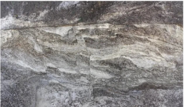
Photo 1: Exposure with faults affecting gravel and silt deposits.
Fig. 2 : Image processing and Interprétation of photo 1
Photo 2: This 0.8-m-high exposure shows normal faults in the injected liquefied sand and the soil horizon.
Clesles gash.
This 3-m-deep gash shows a mixed alluvial filling of sand, gravel and limestone silt. The western top of the cross-section shows a significant detachment above a pervasive level of marl (photo 3). The south-eastern edge of the site shows fluidized sand ejections.
SSW NNE
Photo 3 : Trench exposure at Clesles with seismites (see also photo 4).
gravitational sliding next to the main fault (blue line).
Longueville sand quarry.
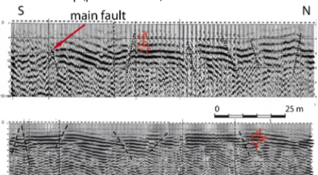
The North-South facing sand quarry and related cross-section at its western side in 1997 expose a significant reverse fault (Baize et al., 2007). A high resolution seismic profile (Fig. 3; Piwakowski, 2000) shows the reverse fault (f) extension into the chalk. We further studied the exposure in 2009 and 2010 and made it possible to observe the eastern extension of the fault, described by Baize et al (2007) in Photo 5. The quarry also shows a small graben and its secondary normal faults sealed towards the top (photos 5 and 6).
Fig. 3: High-resolution seismic profiles across the Longueville quarry site. Reflectors show the main fault (red arrow) with a reverse geometry and folding of sedimentary units reaching é 30-m-depth). : a: 5, 5- b: 8,8 – c: 11 – d:14 – e: 23 – f: 33 (+ or- 7,5%). No vertical exageration.
N S
Photo 5: 6-m- high exposure with small sealed ruptures and faulting of the entire sedimentary units.
Photo 6: The northern side of photo 5 shows a sealed fault (see arrows) by uppermost gravel unit
.
Gourgançon sand quarry.
The NE-SW trending quarry (Fig. 4), previously investigated by Baize et al. (2007) is enlarged and deepened to obtain a large trench. In Figs. 4 and 5, the new exposure shows a set of reverse and normal faults with a decrease in the reverse fault dip towards the surface and the collapse of the overlapping lobe. The reverse fault network shows a consistent dips to the NE and exposes a total ~1 m vertical offset that attests for 2 to 3 episodes of faulting. In addition, a major liquefaction structure (sand blow) appears next to the major reverse fault
(photo 7, Fig.5).
Fig. 4: Mosaic of Gourgançon quarry’s showing the faults and photo 7 (l : liquefaction)
SSW NNE
NE
Photo 7: Major reverse fault associated with liquefaction (see also Fig. 5).
Fig.5: Reverse faulting system and folding of sedimentary units accompanied by a flame structure of liquefaction, attesting for coseismic surface deformation. Illustration with image processing (photoshop) from photo 7.
DISCUSSION – CONCLUSION
Permafrost, solifluction, gravitational sliding can be confused with tectonic features of seismic origin (Van Vliet-Lanoë et al., 2004). In our case and in other sites in intraplate Europe, the glacial origin of some features visible in trenches is well differentiated from faulting (Demoulin, 1996; Vanneste et al., 1999). Quaternary reverse faults visible in seismic profiles (Fig. 3) and at the surface (Fig. 4) are associated with soft sediment deformations (sand blows) that contain Holocene organic materials. The major fold-related fault of Sauvage shows secondary normal faults that can be interpreted as “bending-moment fault” or “extrados” fault. As for the synsedimentary landslide and fault at Clesles, they affect only the summit of the stratigraphic units not linked to sliding on permafrost. At Longueville the extension of certain faults (normal and reverse) into the mudslide (diamicton) substratum (bed) should be noted. The absence of local karsts (Rodet, 1992) in all sites, rules out the interpretation of presumable mass sliding or lateral spreading.
Our investigations in different quarries of the Paris basin and along the the Vittel and Omey faults attest for active faulting and coseismic deformation. Main conclusions can be summarized in four points:
-‐ The largest Quaternary tectonic features and surface deformations are near the major faults of Vittel and Omey. -‐ Active reverse and secondary normal structures accompanied by nearby sand blows are sealed by different stratigraphic units. The structural control of the Seine River chanel by the Omey fault and related deflection in accordance with the regional stress distribution imply a long-term activity with significant reverse slip (see also Fig. 1).
-‐ The existence of fluid ejection, sand liquefaction and load cast at different levels of the stratigraphic section along mainly the Vittel and Omey fault zones.
Prominent tectonic features represented by reverse and normal ruptures, seismites and liquefaction features are located along Omey and Vittel faults. Seismites are visible in all investigated sites and mainly in Clesles and Longueville (see Fig. 1 for location). The age of tectonic episodes is not yet characterized but sand and silt samples near fault ruptures and in sand blow units were collected during a recent field study and are currently undergoing dating by TL-OSL methods.
The active faulting and related surface deformation are very similar to those described in trenches across major surface faulting with coseismic slip. The successive vertical slip on reverse faults and size of liquefaction features such as those observed in the Gourgançon sand quarry may be associated with earthquakes of magnitude Mw ≥ 5.5. The existence of faulting episodes during the late Quaternary calls for the question on the return period of moderate to large earthquakes on, for instance, the Omey fault and its extension towards the SW, and on the Vittel - Bray fault where a late Quaternary activity is also suspected.
References:
Antoine,P ., Marchiol, A., Brocandel, M., Gros,Y., (2005). Découverte de structures périglaciaires (sand- wedges et composite-wedges) sur le site de stockage de déchets radioactifs de l’Aube (France). C. R. Geoscience 337, 1462–1473
Baize, S., Coulon, M., Hibsch, C., Cushing, M., Lemeille, F., Hamard, E., (2007). Non-tectonic deformations of Pleistocene sediments in the eastern Paris basin, France. Bull. Soc. geol. Fr, t. 184, n°3, 367- 381.
Banque de données du sous sol, point 02612X0026/S16.
Benoit, P., Grisoni, J-M. Piwakowski B., Argant, J., (2011). La craie fracturée de Charny le bachot (Aube), témoin envisageable du rejeu quaternaire des accidents de socle du bassin de Paris, Bulletin Inf. Géol. Bass. Paris, 2011, vol 48, n°2, 5-16
Camelbeeck, T., Meghraoui, M., (1998). Geological and geophysical evidence for large paleoearthquakes with surface faulting in the Roer Graben (northwest Europe), Geophys. Journal
International, 132, 347 - 362.
Coulon, M., (1994). Mise en évidence et approche microtectonique des déformations quaternaires en Champagne: implications géodynamiques et conséquences hydrographiques. In: Workshop Morphogenèse cénozoïque de
l’Europe de l’Ouest. Groupe Fr. Géomorph., Rennes.
BRGM, (2013). Site sisfrance : http://www.sisfrance.net/
Demoulin,A.,(1996). Clastic dykes in east Belgium : evidence of upper Pleistocene strong earthquakes west of the lower Rhine rift segment. Journal of the Geological Society, London, Vol. 153, 803-810.
Geological map 1/50 000, (1978),: Fére Champenoise, BRGM n° 224.
Gregoire A. (2003):, Caractérisation des déformations méso-cénozoïques et des circulations de fluides dans l'est du bassin de Paris. Thèse doctorat Univ. Henri Poincaré, Nancy 1, 294. Institut Français du Pétrole, (2000): carte structurale du centre du
bassin de Paris, au toit du rhétien.
Meghraoui, M.,. Crone,A., (2001). Earthquakes and their preservation in the geological records, Journal of Seismology 5,
281-285.
Meghraoui, M., B. Delouis, M. Ferry, D. Giardini, P. Huggenberger, I. Spottke, and M. Granet, (2001). Active normal faulting in the upper Rhine graben and paleoseismic identification of the 1356 Basel earthquake. Science 293, 2070-2073.
Michel, J.P, (1972). Le quaternaire de la région parisienne Thèse présentée pour l'obtention du grade de docteur es sciences naturelles à l'université de Paris VI.
Plaziat, J-C, (2009): Diversité et localisation chronologique des séismes dans les sables marins et éoliens du stampien, au sud de Paris, Bulletin. Inf. Geol. Bass. Paris, volume 46, n°4, 6-49. Piwakowski, B., (2000) : Imagerie de la structure de subsurface par
sismique réflexion très haute résolution, sur le site de Longueville sur Aube, Société Sovep
Philip, H., Bousquet, J.C., Masson, F., 2007. Liquéfaction, figure n° 4.17. In: Séismes et risques sismiques, Dunod, Fr, 83, 87. Rodet, J. 1992, La craie et ses karsts. Centre normand d’étude du
karst et des cavités du sous-sol, Groupe Seine. 427- 515 Vanneste, K., Meghraoui, M., and Camelbeeck, T., (1999). Late
Quaternary earthquake-related soft-sediment deformation along the Belgian portion of the Feldbiss fault, lower Rhine graben, Tectonophysics 309, 57-79.
Van Vliet-Lanoë, B., Magyarib, A., Meillieza, F., (2004). Distinguishing between tectonic and periglacial deformations of quaternary continental deposits in Europe Global and Planetary Change 43, 103–127.