HAL Id: hal-00296994
https://hal.archives-ouvertes.fr/hal-00296994
Submitted on 16 May 2007
HAL is a multi-disciplinary open access
archive for the deposit and dissemination of
sci-entific research documents, whether they are
pub-lished or not. The documents may come from
teaching and research institutions in France or
abroad, or from public or private research centers.
L’archive ouverte pluridisciplinaire HAL, est
destinée au dépôt et à la diffusion de documents
scientifiques de niveau recherche, publiés ou non,
émanant des établissements d’enseignement et de
recherche français ou étrangers, des laboratoires
publics ou privés.
Analysis of the suitability of the German soil texture
classification for the regional scale application of
physical based hydrological model
H. Bormann
To cite this version:
H. Bormann. Analysis of the suitability of the German soil texture classification for the regional scale
application of physical based hydrological model. Advances in Geosciences, European Geosciences
Union, 2007, 11, pp.7-13. �hal-00296994�
www.adv-geosci.net/11/7/2007/
© Author(s) 2007. This work is licensed under a Creative Commons License.
Geosciences
Analysis of the suitability of the German soil texture classification
for the regional scale application of physical based hydrological
model
H. Bormann
University of Oldenburg, Department of Biology and Environmental Sciences, Germany
Received: 15 January 2007 – Revised: 27 March 2007 – Accepted: 4 May 2007 – Published: 16 May 2007
Abstract. Regional scale hydrological simulations are mostly based on the use of standard data sets such as soil maps which are based on soil texture classification schemes. This paper analyses the suitability of the German soil tex-ture classification for the application of a physically based soil-vegetation-atmosphere-transfer scheme. Theoretical soil columns are defined to be able to represent the entire soil tex-ture triangle by a 1% grid of the three particle size classes: sand, clay and silt. These theoretical soil columns are char-acterized by a homogenous soil texture and consist of two layers of increasing bulk density and decreasing content of organic matter with depth. Soil hydraulic parameterisation is derived by applying a pedotransfer function. Continuous wa-ter balance calculations are carried out for a ten year period for all grid cells of the 1% grid. The results of the water bal-ance calculations are compared to the simulation results of the centre of gravity of the respective soil texture class. Tex-ture class specific mean deviations and root mean squared deviations are calculated from the differences between the 1% pixels and texture class representatives. The results re-veal that the loam and silt texture classes show only small deviations from the centres of gravity. For a few sand tex-ture classes and most of the clay textex-ture classes deviations are considerably large. Assuming an equal distributed prob-ability of occurrence of all realisations within a soil texture class, an uncertainty of more than 100 mm/a with respect to runoff and actual evapotranspiration is detected for four clay texture classes, two sand texture classes and one silt texture class. These results are confirmed by a sensitivity analysis investigating the model response for a grid cell compared to the neighboured grid cells. High sensitivities mainly appear for sandy and clayey soils while the sensitivity of the model for loam and silt soils is smaller. Resuming it can be stated that most of the texture classes of the German texture
classifi-Correspondence to: H. Bormann
cation scheme are suitable for the application of a physically based model, on regional scale in particular. Clay texture classes can be expected to cause high simulation uncertain-ties.
1 Introduction
The application of physically based soil-vegetation-atmosphere-transfer schemes (SVAT) at the regional scale is mostly based on standard data sets such as regional scale soil maps as detailed measurements of soil hydraulic characteristics are not available. Unfortunately the soil maps mostly do not contain model parameters directly. Information on soil texture, soil compaction and organic content is available only. Thus model parameters have to be taken from literature (e.g. M¨uller, 1997) or they have to be derived from the readily available data from the soil maps. This can be accomplished by the application of pedotransfer functions (PTF). PTF describe the correlation between soil composition and soil hydraulic parameters. Many of them are based on regression equations of measured soil samples (e.g. Rawls and Brakensiek, 1985). The use of PTF in hydrological modelling is well accepted if no detailed data are available. Several comparative studies have been performed to evaluate different pedotransfer functions (e.g. Wagner et al., 2004; W¨osten et al., 2001; Pachepsky and Rawls, 1999; Tietje and Tapkenhinrichs, 1993). However, most PTF continuously describe the relation between soil texture and soil hydraulic parameterisation while soil maps mostly contain the information on soil texture classes only. Thus besides the problem of decreasing information with increasing scale of the soil map (Bormann et al., 1999b) the question on the relevance of uncertainty induced by using classified soil data instead of detailed and continuous soil textural information arises.
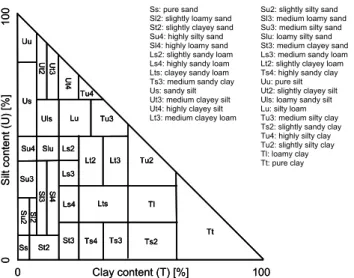
8 H. Bormann: Analysis of the suitability of the German soil texture classification Uu Us U t2 Ut3 Ss U t4 Su4 Su3 Uls Lu Tu4 Tu3 Slu Ls2 Ls3 Lt2 Lt3 Tu2 Tl Tt Ts2 Ts3 Ts4 St3 Lts Ls4 St2 Su 2 Sl 2 Sl 3 Sl4 0 Clay content (T) [%] 100 0 S ilt c o n te n t (U ) [% ] 1 0 0 Uu Us U t2 Ut3 Ss U t4 Su4 Su3 Uls Lu Tu4 Tu3 Slu Ls2 Ls3 Lt2 Lt3 Tu2 Tl Tt Ts2 Ts3 Ts4 St3 Lts Ls4 St2 Su 2 Sl 2 Sl 3 Sl4 Uu Us U t2 Ut3 Ss U t4 Su4 Su3 Uls Lu Tu4 Tu3 Slu Ls2 Ls3 Lt2 Lt3 Tu2 Tl Tt Ts2 Ts3 Ts4 St3 Lts Ls4 St2 Su 2 Sl 2 Sl 3 Sl4 0 Clay content (T) [%] 100 0 S ilt c o n te n t (U ) [% ] 1 0
0 Ss: pure sand Su2: slightly silty sand Sl2: slightly loamy sand Sl3: medium loamy sand St2: slightly clayey sand Su3: medium silty sand Su4: highly silty sand Slu: loamy silty sand Sl4: highly loamy sand St3: medium clayey sand Ls2: slightly sandy loam Ls3: medium sandy loam Ls4: highly sandy loam Lt2: slightly clayey loam Lts: clayey sandy loam Ts4: highly sandy clay Ts3: medium sandy clay Uu: pure silt Us: sandy silt Ut2: slightly clayey silt Ut3: medium clayey silt Uls: loamy sandy silt Ut4: highly clayey silt Lu: silty loam Lt3: medium clayey loam Tu3: medium silty clay Ts2: slightly sandy clay Tu4: highly silty clay Tu2: slightly silty clay Tl: loamy clay
Tt: pure clay
Fig. 1. Definition of the German soil texture classes according to
Ad-hoc-AG Boden (2005). T = clay, S = sand, U = silt, L = loam; 2 = slight, 3 = medium, 4 = high.
Based on this problem this study aims at the quantifica-tion of the uncertainties of water balance calculaquantifica-tions based on soil texture classes. Ensuing, an evaluation of the existing German soil texture classification (Ad-hoc-AG Boden, 2005) for regional scale water balance modelling using a physically based model is carried out. In this study, the soil texture tri-angle is represented by a 1% grid of soil texture composition resulting in 5050 different soil textures. As real homogenous soil profiles are not available for all 5050 realisations of the 1% grid, theoretical soil columns are defined consisting of two layers of homogenous soil texture. So the entire soil texture triangle can be parameterised using a pedotransfer function. Water balance calculations can be performed for the entire space of the soil texture triangle. Based on these calculations, the suitability of any soil texture classification can be analysed by investigating the variability of the model sensitivity on changes in soil texture and by comparing all realisations of a soil texture class with one representative. In this study the centre of gravity (CG) is assumed to be repre-sentative for a texture class.
2 Material and methods
2.1 The German soil texture classification
According to the German soil texture classification (Ad-hoc-AG Boden, 2005) the soil texture triangle is divided into 31 texture classes: seven clay classes, ten loam classes, seven silt classes and seven sand classes. The boundaries of the texture classes are shown in Fig. 1. For each texture class val-ues on porosity depending on soil compaction are provided. Additionally, correction factors for high organic contents are available.
Table 1. Properties and design of the theoretical soil columns.
Layer Depth Bulk density Organic carbon
Upper 0–30 cm Low/Medium 1–2%
Lower 30–200 cm Medium/High 0
2.2 Simulation model
The SIMULAT model (Diekkr¨uger and Arning, 1995; Bor-mann, 2001) is used in this study to calculate water flows and water balances for all representations of the 1% grid of the soil texture triangle. SIMULAT is a physically based and one dimensional SVAT scheme using the following process descriptions:
– Potential evapotranspiration is calculated by the
Penman-Monteith method. In order to compute the ac-tual evapotranspiration, potential evapotranspiration is reduced by a function taking the actual soil moisture status into account.
– Infiltration is determined using a semi-analytical
solu-tion of the Richards’ equasolu-tion according to Smith and Parlange (1978).
– Soil water flow is calculated by a numerical solution of
the Richards’ equation using finite differences.
– The calculation of the snow melt is based on the degree
day method.
– Interflow is computed by Darcy’s law. Lateral outflow
from a computational layer occurs under partially satu-rated conditions on an inclined site. The outflow rate is proportional to the saturated lateral conductivity and the inclination.
SIMULAT has been validated by several studies at the plot scale (Diekkr¨uger and Arning, 1995), at the small catchment scale (Bormann et al., 2005) and at the mesoscale (Bormann et al., 1999a). For small scale applications, the simulation quality without any parameter calibration was comparable to the quality of other calibrated site models (Diekkr¨uger et al., 1995).
2.3 Parameter estimation of theoretical soil columns As introduced before, no real world data base is available to represent the whole space of the texture triangle in a 1% grid. Therefore it is decided to introduce theoretical soil columns consisting of a homogenous soil textural composition. To represent an upper humous layer and to approximate the in-creasing bulk density with depth, two layers are introduced: an upper layer of 30 cm and a lower layer of 170 cm depth while the upper layer shows a lower bulk density and a higher
content of organic carbon compared to the lower layer (Ta-ble 1). Porosity is taken from Ad-ho-AG Boden (2005). As porosity values are only available for texture classes, the val-ues provided for different bulk density classes are assumed for the centres of gravity of each texture class. The interpola-tion between the centres of gravity is performed by a bi-linear approach (Nieschulz, 1997) to provide continuous informa-tion on porosity. Finally the pedotransfer funcinforma-tion (PTF) of Rawls and Brakensiek (1985) is applied to all theoretical soil columns representing the 5050 pixels of the 1% grid to derive the soil hydraulic model parameters according to the Brooks and Corey parameterisation for the water retention curve and for the unsaturated conductivity curve. The PTF is applied for the whole space of the texture triangle bearing in mind that Rawls and Brakensiek (1985) limited the applicability to soils with a sand content between 5% and 70% and a clay content between 5% and 60%. The lower boundary condi-tion is defined by free drainage. The theoretical soil columns have an inclination of 15%. They are covered by short grass. A ten year climatic data set (1980–1989) with hourly data of the G¨ottingen climate station in central Germany is used as model input.
2.4 Evaluation measures
In order to evaluate the suitability of the German soil texture classification for the application of the SIMULAT model, three different measures are defined. Applying these mea-sures, the ability of the classification to represent the vari-ability within the texture triangle with respect to the impact of soil texture on the calculation of hydrological fluxes can be estimated. The measures can also be used to evaluate the variability within particular soil texture classes and the abil-ity of class representatives to represent the average behaviour of a texture class.
1. Mean deviation (MD): The mean deviation is defined as the average difference between simulated water flows (Q) of the centre of gravity (CG) of a particular tex-ture class and all n grid cells of the 1% grid within the texture class. A small MD stands for small deviations in the texture class or for the fact that positive and negative deviations of different grid cells are balanced:
MD= n P i=1 (QCG−Qi) n (1)
2. Root mean squared deviation (RMSD): The RMSD is defined as the root of the average of the squared differ-ences between simulated water flows (Q) of the centre of gravity (CG) of a particular texture class and all n grid cells of the 1% grid within the texture class. Pos-itive and negative deviations of different grid cells
can-not be balanced. Therefore a small RMSD stands for small deviations over the entire texture class:
RMSD= v u u u t n P i=1 (QCG−Qi)2 n (2)
3. Neighbourhood sensitivity (NS): The calculation of the neighbourhood sensitivity of a grid cell is performed by calculating the square root of the mean squared differ-ence between simulated water flows of the grid cell (i) compared to four adjacent grid cells consisting of 1 per-cent more or less clay (T ) and silt (U ). Areas with high neighbourhood sensitivity highlight areas where small deviations in the soil composition result in a high mod-elling uncertainty. Areas of high neighbourhood sensi-tivity therefore should be represented by small texture classes: NS= s P (Qi−QU +1;T +1)2+(Qi−QU +1;T −1)2+(Qi−QU −1;T +1)2+(Qi−QU −1;T −1)2 4 (3) From all n neighbourhood sensitivity values within a texture class (NSi) the average neighbourhood sensi-tivity (ANS) is calculated. The average neighbourhood sensitivity therefore is a measure for to assess the un-certainty of the individual texture class with respect to simulated water flows:
ANS= n P i=1 NSi n (4)
3 Water balance simulations
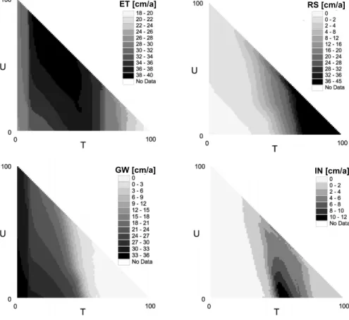
3.1 Continuous simulations on the soil texture triangle Water balance calculations are performed for each of the 5050 theoretical soil columns of the 1% grid covering the soil texture triangle as well as for the centres of gravity of each soil texture class for a ten year period using model con-figuration introduced in Sect. 2.3. The first two years of the simulation time are used as warm up period. The results for the remaining eight years are used for the analysis. Fig-ure 2 shows the simulated mean annual water flows for the entire soil texture triangle. As expected from process un-derstanding, sandy and silty soils show highest groundwater recharge rates, while clayey soils have the highest surface runoff generation rates. Actual evapotranspiration is highest for loamy and silty soils while interflow only occurs at clayey and loamy soils. For further analysis the three simulated runoff components (surface runoff, interflow and groundwa-ter recharge) are summed up to the total runoff (QT). Further analyses are performed for OT and for actual evapotranspira-tion (ET).
10 H. Bormann: Analysis of the suitability of the German soil texture classification
ET [cm/a] RS [cm/a]
GW [cm/a] IN [cm/a] ET [cm/a]
ET [cm/a] RS [cm/a]RS [cm/a]
GW [cm/a] IN [cm/a]IN [cm/a]
Fig. 2. Simulated annual water flows for a 1% grid over the soil texture triangle. ET = actual evapotranspiration, RS = surface runoff, GW =
groundwater recharge, IN = interflow.
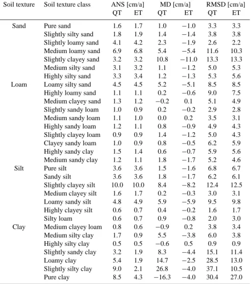
3.2 Texture class based evaluation of simulation results Based on the simulations of the water fluxes based on the 1% grid and for the centres of gravity of the 31 texture classes according to the Ad-hoc-AG Boden (2005), mean deviations (MD) and root mean squared deviations (RMSD) of the sim-ulated total runoff and actual evapotranspiration are calcu-lated for all texture classes using Eqs. (1) and (2). One should keep in mind that the PTF has not been developed for the en-tire soil texture triangle. All results are summarised in Ta-ble 2. High texture class specific values for MD as well as RMSD can be identified for most of the clay texture classes. Pure clay, loamy clay as well as slightly sandy and slightly silty clay exhibit the highest deviations. High deviations are also detected for loamy sands and for clayey silts, while most loam and silt texture classes show small deviations. Calcu-lating the mean RMSD values for the four main soil tex-tures, clay soils show highest RMSD values (17.4 cm/a for QT and 10 cm/a for ET) followed by sandy soils (6.4 cm/a for QT and 5.8 cm/a for ET) and loam soils (5.9 cm/a for QT and 6.1 cm/a for ET). Silty soils show the smallest RMSD (5.6 cm/a for QT and 6.2 cm/a for ET).
An analysis of the structure of the deviations between the grid based water balance calculations and the centres of
grav-ity of the texture classes (1QT, Fig. 3) provides indication for the suitability of the texture classes for regional scale hy-drological modelling. It can be assumed that on the regional scale a texture class is represented by a large number of re-alisations which are equally distributed in the space of the texture class. Deviations therefore compensate with respect to the regional water balance despite soil texture heterogene-ity. It is assumed that for regional application a small MD stands for a small uncertainty even if the RMSD is high. On the other hand, texture classes with high MD (and a high RMSD) are assumed to cause a high modelling uncertainty and therefore are less suitable for physically based model ap-plications. In this case, deviations do not compensate but add up with respect to the regional water balance. The mod-elling uncertainty is higher. For example, the silty loam (Lu) shows low values for both, MD and RMSD. The implied un-certainty is low. The highly loamy sand (Sl4) has a small MD but a considerably high RMSD. The Sl4 shows a sym-metrical pattern of positive and negative deviations in QT and therefore can also be assumed to cause only small uncertainty on the regional scale. Texture classes causing a high uncer-tainty even for regional scale model applications for example are the slightly sandy clay (Ts2) and the slightly silty clay (Tu2). Both soils show high MD and RMSD values and
Table 2. Texture class averages of model sensitivity and texture class internal variability with respect to the simulated total runoff (QT
= surface runoff + interflow + groundwater recharge) and the actual evapotranspiration (ET) of the centre of gravity. ANS = average neighbourhood sensitivity; MD = mean deviation; RMSD = root mean squared deviation).
Soil texture Soil texture class ANS [cm/a] MD [cm/a] RMSD [cm/a]
QT ET QT ET QT ET
Sand Pure sand 1.6 1.7 1.0 −1.0 3.3 3.3
Slightly silty sand 1.8 1.9 1.4 −1.4 3.8 3.8
Slightly loamy sand 4.1 4.2 2.3 −1.9 2.6 2.2
Medium loamy sand 6.9 6.8 5.4 −5.4 11.6 10.3
Slightly clayey sand 3.2 3.2 10.8 −11.0 13.3 13.3
Medium silty sand 3.1 3.2 1.1 −1.2 5.0 5.3
Highly silty sand 3.3 3.4 1.2 −1.3 5.3 5.6
Loam Loamy silty sand 4.5 4.5 5.2 −5.1 8.5 8.5
Highly loamy sand 1.1 1.1 0.2 −0.6 9.0 7.5
Medium clayey sand 1.3 1.2 −0.2 0.1 5.1 4.9
Slightly sandy loam 1.0 0.9 0.2 −0.2 2.9 2.8
Medium sandy loam 1.1 1.0 0.0 0.2 3.5 3.1
Highly sandy loam 1.2 1.1 0.8 −0.9 4.9 4.3
Slightly clayey loam 0.9 0.9 1.4 −1.2 5.0 4.3
Clayey sandy loam 1.0 0.9 0.8 −0.5 6.2 5.9
Highly sandy clay 1.5 1.4 0.6 −0.7 5.9 5.6
Medium sandy clay 1.2 1.1 1.8 −1.7 5.2 4.6
Silt Pure silt 3.6 3.6 1.5 −1.6 6.8 6.7
Sandy silt 3.6 3.6 1.8 −1.7 6.2 6.1
Slightly clayey silt 10.0 10.0 8.4 −8.2 12.4 12.5
Medium clayey silt 1.6 1.7 0.2 −0.3 3.0 3.1
Loamy sandy silt 4.8 4.9 5.9 −5.9 9.5 9.8
Highly clayey silt 0.6 0.7 0.4 −0.2 1.6 1.7
Silty loam 0.6 0.7 0.9 −0.8 2.0 3.0
Clay Medium clayey loam 0.8 0.6 −0.9 0.2 3.8 3.4
Medium silty clay 1.7 0.9 5.5 −3.8 6.0 3.8
Highly silty clay 0.5 0.5 −0.6 0.5 0.9 0.9
Slightly sandy clay 3.2 1.9 8.3 −4.4 15.1 11.4
Loamy clay 5.4 1.9 14.7 −2.5 28.5 13.0
Slightly silty clay 9.0 2.1 26.8 −4.0 37.1 10.5
Pure clay 8.5 4.3 −16.3 −4.0 30.4 27.0
tremely asymmetrical patterns of positive and negative devia-tions (1QT). Thus, a combination of the results shown in Ta-ble 2 and Fig. 3 can be used to classify the texture classes in terms of suitability for physically based modelling in general (small MD and RMSD, symmetric structure of deviations), suitability for regional scale model applications (small MD, large RMSD, symmetric structure of deviations) and limited suitability for model application in general (large MD and RMSD, asymmetric structure of deviations).
3.3 Analysis of model sensitivity
The simulations of the water fluxes based on the 1% grid are also used for the assessment of model sensitivity to 1%-changes in the soil texture composition using Eqs. (3) (neigh-bourhood sensitivity, NS) and (4) (average neigh(neigh-bourhood sensitivity, ANS). Again it should be kept in mind that
er-rors may occur if the PTF is applied for the entire soil tex-ture triangle. Figure 4 shows the neighbourhood sensitivity (NS) for the entire texture triangle, and the texture class spe-cific values of the average neighbourhood sensitivity (ANS) are shown in Table 2. Notably high values of NS are ob-served for high clay contents (pure clay (Tt) in particular) and for clay contents of 10–14%. For these clay contents the neighbourhood sensitivity is extremely high (independent of the remaining soil composition of silt and sand, Fig. 4). This fact can also be found in Table 2. Besides those tex-ture classes with high clay contents (pure clay (Tt), slightly silty clay (Tu2)) comparably high neighbourhood sensitivi-ties can be found for low clay contents (slightly clayey silt (Ut2), medium loamy sand (Sl3)). While the texture classes with high clay contents are partly out of the area where the PTF is valid according to Rawls and Brakensiek (1985), the texture classes with 10–14% clay content mostly are within
12 H. Bormann: Analysis of the suitability of the German soil texture classification Uu Us U t2 Ut3 Ss U t4 Su4 Su3 Uls Lu Tu4 Tu3 Slu Ls2 Ls3 Lt2 Lt3 Tu2 Tl Tt Ts2 Ts3 Ts4 St3 Lts Ls4 St2 Su 2 Sl 2 Sl 3 Sl 4 ∆QT [cm/a] Uu Us U t2 Ut3 Ss U t4 Su4 Su3 Uls Lu Tu4 Tu3 Slu Ls2 Ls3 Lt2 Lt3 Tu2 Tl Tt Ts2 Ts3 Ts4 St3 Lts Ls4 St2 Su 2 Sl 2 Sl 3 Sl 4 Uu Us U t2 Ut3 Ss U t4 Su4 Su3 Uls Lu Tu4 Tu3 Slu Ls2 Ls3 Lt2 Lt3 Tu2 Tl Tt Ts2 Ts3 Ts4 St3 Lts Ls4 St2 Su 2 Sl 2 Sl 3 Sl 4 ∆QT [cm/a]
Fig. 3. Deviations between simulated total runoff for the texture
class representatives (centres of gravity) compared to all other rep-resentations (1% grid points) within a soil texture class (1QT). The central area of the soil texture triangle delimited by the dashed line is the area where the PFT after Rawls and Brakensiek (1985) is valid.
the valid space. But as the sand and silt dominated texture classes are small compared to the clay dominated texture classes (Fig. 1), the identified mean and root mean squared deviations and therefore the uncertainties for model appli-cations are also small compared to those of the clay texture classes. Hence, the analysis of the neighbourhood sensitivity highlights “hot spots” of high model uncertainty and be can used to analyse whether texture classes are small enough to reduce uncertainty to an acceptable level.
4 Discussion
The analysis of the simulation results reveals soil texture class specific deviations and sensitivities implying soil tex-ture class specific uncertainties for regional scale model ap-plications. Further model simulations show that the texture class specific systematics of the simulation results does not depend on the definition of the theoretical soil columns and on the chosen boundary conditions of the simulations. Ad-ditional simulations with different vegetation cover (mixed forest instead of short grass) result in the same ranking of texture classes with respect to deviations (MD and RMSD). A reduced soil compaction resulting in smaller bulk densi-ties as well as the comparison of dry and wet years have an impact on the size of the deviations but also do not alter the
Uu Us U t2 Ut3 Ss U t4 Su4 Su3 Uls Lu Tu4 Tu3 Slu Ls2 Ls3 Lt2 Lt3 Tu2 Tl Tt Ts2 Ts3 Ts4 St3 Lts Ls4 St2 Su 2 Sl 2 Sl 3 Sl4 NS (QT) [cm/a] Uu Us U t2 Ut3 Ss U t4 Su4 Su3 Uls Lu Tu4 Tu3 Slu Ls2 Ls3 Lt2 Lt3 Tu2 Tl Tt Ts2 Ts3 Ts4 St3 Lts Ls4 St2 Su 2 Sl 2 Sl 3 Sl4 Uu Us U t2 Ut3 Ss U t4 Su4 Su3 Uls Lu Tu4 Tu3 Slu Ls2 Ls3 Lt2 Lt3 Tu2 Tl Tt Ts2 Ts3 Ts4 St3 Lts Ls4 St2 Su 2 Sl 2 Sl 3 Sl4 NS (QT) [cm/a]
Fig. 4. Neighbourhood sensitivity (NS) for total simulated runoff
(QT = surface runoff + interflow + groundwater recharge). The cen-tral area of the soil texture triangle delimited by the dashed line is the area where the PTF after Rawls and Brakensiek (1985) is valid.
ranking of soil texture classes with respect to the deviations as shown by Table 2.
For all simulation variants the largest uncertainty is de-tected for clay texture classes. The highest sensitivities sides high clay contents are detected for clay contents be-tween 10 and 14%. This indicates that areas within the tex-ture triangle showing high neighbourhood sensitivities (NS) should be covered by smaller texture classes than areas with low NS values. The German texture classification (Ad-hoc-Ag Boden, 2005) allows for this fact and mostly shows small texture classes for soil textures with 10–14% clay content (e.g. Sl3, Ut2, see Fig. 4). Anyway, the clay dominated tex-ture classes cover large areas of the textex-ture triangle and there-fore show large deviations (MD and RSMD). So they are ex-pected to cause high uncertainties in the model application. On the other hand soils with clay contents exceeding 60% are relatively scarce in the field compared to sand and silt dom-inated soils. Thus the impact on regional scale modelling results may be relatively small. Furthermore as mentioned above the results for soil columns with high clay contents should be handled carefully because the PFT according to Rawls and Brakensiek (1985) may be not valid for those tex-ture classes. The results presented in this study also may be dependent on the chosen representation of the pF-curve (Brook and Corey approach), the PTF and the model code. Therefore additional investigations should be performed, e.g. based on the van Genuchten approach, further PTFs and an-other SVAT model.
Resuming, the implications of applying the German soil texture classification for regional hydrological modelling can
be summarized as follows: Silt and loam texture classes show small deviations and sensitivity and therefore are applicable for large scale modelling. Some sand texture classes show large RMSD values and sensitivities, but the classes are small compared to other classes and are therefore applicable for large scale modelling (e.g. Sl3, Ut2). Clay classes show large deviations and sensitivities (e.g. Tl, Tu2, Ts2). The classes are large compared to other classes and are therefore only applicable for large scale modelling if high uncertainties are acceptable (e.g. in case of small areal fractions of clay soils). With an increasing scale of the soil map also the applicabil-ity of classification schemes decreases as the heterogeneapplicabil-ity of soil properties can be represented no more. Alternatively, Monte Carlo techniques can be applied to represent the po-tential variability within soil texture classes instead of one representative (e.g. centre of gravity). This is not necessary in large regions consisting of a large number of simulation units as the high number of units statistically can represent the natural heterogeneity of soils.
5 Conclusions
In this study continuous water balance simulations on a 1% grid covering the entire soil texture triangle have been per-formed. The results indicate that the highest uncertainties can be expected for clay soils which are partly not covered by the PTF data base. Additionally high sensitivities could be identified for soils with 10–14% clay content. The German texture classification accounts for this high neighbourhood sensitivity and defines relatively small texture classes except for clay soils. Nonetheless, clay soils with clay contents larger than 60% show high deviations compared to soil tex-ture class representatives. Therefore high uncertainties can be expected for local and regional scale model applications. While on the local scale observed soil data should be used to minimise uncertainties of model applications, the German texture classification seems to be appropriate for regional scale hydrological model applications because for most soil texture classes, negative and positive deviations in calculated water flows from the class representative are balanced. Only in clay dominated regions the uncertainties caused by soil texture classification may become significant.
Acknowledgements. The author thanks the organisers of the Potsdam-Workshop on “Großskalige Modellierung in der Hydrolo-gie” for the excellent organisation of the Workshop.
Edited by: K.-E. Lindenschmidt Reviewed by: M. Fink and C. Gattke
References
Ad-hoc-AG Boden: Bodenkundliche Kartieranleitung, 5. Aufl., 438 p., Hannover, Schweizerbart, 2005.
Bormann, H., Giertz, S., and Diekkr¨uger, B.: Hydrological catch-ment models between process representation, data availability and applicability for water management – case study for Benin, IAHS-Publication 295, 86–93, 2005.
Bormann, H.: Hochskalieren von prozessorientierten Wassertrans-portmodellen – Methoden und Grenzen, M¨unchen, Herbert-Utz-Verlag-Wissenschaft (Reihe Geowissenschaften), 164 p., 2001. Bormann, H., Diekkr¨uger, B., and Renschler, C.: Regionalization
concept for hydrological modelling on different scales using a physically based model: results and evaluation, Phys. Chem. Earth B., 24(7), 799–804, 1999a.
Bormann, H., Diekkr¨uger, B., and Richter, O.: Effects of spatial data resolution on the calculation of regional water balances, in: Regionalization in Hydrology, edited by: Diekkr¨uger, B., Kirkby, M., and Schr¨oder, U., IAHS-Publication, 254, 193–202, 1999b. Diekkr¨uger, B. and Arning, M.: Simulation of water fluxes using
different methods for estimating soil parameters, Ecol. Model., 81(1–3), 83–95, 1995.
Diekkr¨uger, B., S¨ondgerath, D., Kersebaum, K. C., and McVoy, C. W.: Validity of agroecosystem models – A comparison of results of different models applied to the same data set, Ecol. Model., 81(1–3), 3–29, 1995.
M¨uller, U.: Auswertungsmethoden im Bodenschutz. Dokumenta-tion zur Methodenbank des Nieders¨achsischen Bodeninforma-tionssystems (NIBIS), Hannover, NLfB, Schweizerbart, 1997. Nieschulz, K.-P.: Mathematisch-bodenkundliche Regionalisierung
des Bodenwasserhaushalts, Landschafts¨okologie und Umwelt-forschung 27, TU Braunschweig, 227 p., 1997.
Pachepsky, Y. A. and Rawls, W. J.: Accuracy and Reliability of pedotransfer Functions as Affected by Grouping Soils, Soil Sci. Soc. Am. J. 63, 1748–1757, 1999.
Rawls, W. J. and Brakensiek, D. L.: Prediction of soil water prop-erties for hydrologic modeling, in: Watershed Management in the Eighties (Proceedings), edited by: Jones, E. and Ward, T. J., ASCE, Denver, Colorado, 30.4.–2.5.1985, 293–299, 1985. Smith, R. E. and Parlange, J.-Y.: A parameter-efficient hydrologic
infiltration model, Water Resour. Res., 14(3), 533–538, 1978. Tietje, O. and Tapkenhinrichs, M.: Evaluation of pedotransfer
func-tions, Soil Sci. Soc. Am. J., 57, 1088–1095, 1993.
Wagner, B., Tarnawski, V. R., and St¨ockl, M.: Evaluation of pe-dotransfer functions predicting hydraulic properties of soils and deeper sediments, J. Plant Nutr. Soil Sci., 167(2), 236–245, 2004. W¨osten, J. H. M., Pachepsky, Y. A., and Rawls, W. J.: Pedotransfer functions: bridging the gap between available basic soil data and missing soil hydraulic characteristics, J. Hydrol., 251, 123–150, 2001.