HAL Id: hal-00296960
https://hal.archives-ouvertes.fr/hal-00296960
Submitted on 26 Sep 2006
HAL is a multi-disciplinary open access
archive for the deposit and dissemination of
sci-entific research documents, whether they are
pub-lished or not. The documents may come from
teaching and research institutions in France or
abroad, or from public or private research centers.
L’archive ouverte pluridisciplinaire HAL, est
destinée au dépôt et à la diffusion de documents
scientifiques de niveau recherche, publiés ou non,
émanant des établissements d’enseignement et de
recherche français ou étrangers, des laboratoires
publics ou privés.
Integration of water balance models in RIVERTWIN
J. Götzinger, J. Jagelke, R. Barthel, A. Bárdossy
To cite this version:
J. Götzinger, J. Jagelke, R. Barthel, A. Bárdossy. Integration of water balance models in
RIVER-TWIN. Advances in Geosciences, European Geosciences Union, 2006, 9, pp.85-91. �hal-00296960�
www.adv-geosci.net/9/85/2006/
© Author(s) 2006. This work is licensed under a Creative Commons License.
Advances in
Geosciences
Integration of water balance models in RIVERTWIN
J. G¨otzinger, J. Jagelke, R. Barthel, and A. B´ardossy
Institute for Hydraulic Engineering, Universitaet Stuttgart, Germany
Received: 23 January 2006 – Revised: 22 May 2006 – Accepted: 3 July 2006 – Published: 26 September 2006
Abstract. In the project RIVERTWIN climate, hydrologic,
groundwater and water quality models are integrated in or-der to evaluate river basin management plans established for the implementation of the EU Water Framework Directive. In such integrated models, which try to simulate all relevant processes in a river basin realistically, modelling of the water balance plays a key role. Therefore the integration of hydro-logical and groundwater models requires special attention. In this case study, the hydrological model simulates discharge and daily groundwater recharge in a high spatial resolution. Using the latter as input, the groundwater model calculates groundwater levels and groundwater runoff, which is then returned to the hydrological model. Such integration on the meso-scale brings up new problems such as commensurabil-ity, verification and compatibility of internal state variables and fluxes, but also provides the possibility to analyse the underlying assumptions and simplifications. As an exam-ple of this modelling approach the simulation of groundwater recharge, groundwater levels and groundwater runoff in the Neckar catchment are discussed and the problems of the cur-rent integration concept are described.
1 Introduction
The EU Water Framework Directive and the EU Water Ini-tiative for the Millennium Development Goals have posed new questions for hydrological research in the past few years. Besides the many European projects supporting the implementation of this directive (K¨am¨ari, 2006; Refsgaard, 2002; http://www.harmoni-ca.info/), the challenges men-tioned above have lead to considerable effort in predicting the impact of global change on river basins and their man-agement (Zehe and B´ardossy, 2002; Gaiser et al., 2003;
Correspondence to: J. G¨otzinger
(jens.goetzinger@iws.uni-stuttgart.de)
http://www.glowa.org/; http://www.kliwa.de/; Stock, 2005). Most of these projects face similar problems when models from different disciplines are integrated. The interfaces have to be clearly defined and often compromises have to be made between the demands of the models, the data availability and the objectives of the study. A common problem is also that input and state variables are sparse or missing in the desired resolution. If the fluxes between models cannot be measured at all, innovative solutions have to be found to represent the natural system in a realistic way. As an example, the inte-grated modelling of groundwater recharge and groundwater runoff in the meso-scale Neckar basin (14 000 km2)is dis-cussed in this paper. For smaller scales similar studies have shown that the integration of different models is possible (Bronstert et al., 2005). However on a larger scale, additional problems emerge some of which are discussed here (see also Barthel et al., 2005).
As a result of the equifinality discussion (Beven and Bin-ley, 1992), it has been proposed to reduce parameter uncer-tainty by using multi-response data or multi-criteria calibra-tion. Kuczera and Mroczkowski (1998) observed that aug-menting stream flow data with groundwater level data did not improve the identifiability of a nine parameter concep-tual model. On the other hand, the use of stream salin-ity data in addition to stream flow data in the calibration process substantially reduced the parameter uncertainty in their study. Seibert (2000) discovered that the parameters of “HBV light” were significantly constrained when calibrated against stream flow and groundwater level data. For one of the catchments considered in the study the multi-criteria cal-ibration even led to an improvement of the model structure.
As many conceptual hydrological models simulate the groundwater contribution by a linear storage reservoir, the integration of a physically based groundwater model should improve the modelling results and lead to more realistic projections for the future. Earlier studies have also shown that uncertainty largely depends on input data, errors in the
86 J. G¨otzinger et al.: Integration of water balance models in RIVERTWIN conceptual model (scale and abstraction) or
commensura-bility issues (Beven and Binley, 1992). Integrating further models enables assumptions and simplifications of concep-tual models to be analysed and a multi-response validation of the integrated model to be performed, which may pro-vide more insight and trust in the results. Comparable to the mentioned studies, the integrated surface and groundwater models are calibrated against runoff and groundwater levels, respectively. But through the integration concept presented here they will also be conditioned to simulate the ground-water recharge and groundground-water runoff in a model consistent way. By this indirect check on internal processes the uncer-tainty of the modelling complex can be reduced. Some of the problems encountered during the modelling process will be presented and discussed.
This study is part of the project “RIVERTWIN” which aims at adjusting, testing and implementing an integrated re-gional model for the strategic planning of water resources management in twinned river basins under contrasting eco-logical, social and economic conditions. The regional model takes into account the impacts of demographic trends, eco-nomic and technological development and the effects of global climate and land use changes on the availability and quality of water bodies in humid temperate, subhumid trop-ical as well as semiarid regions. The integration framework was tested in the European Neckar basin with high data avail-ability and data density. The transferavail-ability of the model to other regions with different economic levels, ecological standards and with low data availability is currently being tested by the project team and river basin organisations in two river basins, in West Africa (Benin) and Central Asia (Uzbekistan). More detailed information can be found under http://www.rivertwin.de.
2 The models HBV, LARSIM and MODFLOW
A wide variety of hydrological models have been devel-oped in the past century and are applied for water resources management (Singh, 1995). In order to quantify the ef-fect of changing land use and climate with a high spatial and temporal resolution properly, the models have to ful-fil certain criteria: They should be simple enough to work on large scales, with sparse data but also be able to simu-late future climate scenarios. This is especially important for the model application in Benin and Uzbekistan in order to demonstrate the transferability of the concepts to other basins. At the same time, the model concept and parame-terization should be based on a reasonable representation of the dominant catchment processes and should be able to re-flect changes in catchment characteristics and forcing data. Therefore, a version of the semi-distributed conceptual HBV model (Bergstr¨om, 1995) was modified according to these re-quirements. The results are compared to the LARSIM model (Bremicker, 2000) which is operational at the State Institute
for Environmental Protection Baden-W¨urttemberg and was used in a regional climate change impact study focusing on floods (http://www.kliwa.de/).
The HBV model concept was developed by the Swedish Meteorological and Hydrological Institute (SMHI) in the early 1970’s. It has conceptual routines for calculating snow accumulation and melt, soil moisture and runoff genera-tion, runoff concentration within the subcatchment, and flood routing of the discharge in the river network. The snow rou-tine uses the degree-day approach. Soil moisture is calcu-lated by balancing precipitation and evapotranspiration us-ing field capacity and permanent wiltus-ing point as parame-ters. Runoff generation is simulated by a nonlinear func-tion of the actual soil moisture and precipitafunc-tion. The runoff concentration is modelled by two parallel nonlinear reser-voirs representing the direct discharge and the groundwater response. Flood routing between the river network nodes uses the Muskingum method. Additional information about the HBV model in general can be found in Uhlenbrook et al. (2004), Hundecha and B´ardossy (2004) and Hundecha (2005). The main modification of the version used in this study is that the runoff generation and concentration routines are fully distributed on a 1 km2raster. Parameterization is achieved by regionalization using soil, topography and land use data. As the parameterization is not the main focus of this paper the reader is referred to G¨otzinger and B´ardossy (2005).
The water balance model LARSIM (Large Area Runoff Simulation Model) is a mesoscale model developed to sim-ulate the water balance of large river basins continuously. It incorporates the processes of interception, evapotranspira-tion, water storage in soils and aquifers, runoff generation in the catchment and translation and retention in river channels. Snow accumulation and snowmelt are taken into account as well as artificial influences (e.g. storage basins, diversions or water transfer between different basins). LARSIM com-bines deterministic hydrological model components that are generally applicable and based on available geographic and meteorologic data, like the Xinanjiang model (Zhao, 1977) or parallel linear storages (Bremicker and Gerlinger, 2000).
For modelling the groundwater flow the physically based 3-D finite difference groundwater flow model MODFLOW (McDonald and Harbaugh, 1988) is used, which is a very well verified code for mathematical modelling of saturated groundwater flow. MODFLOW is based on the horizon-tal and vertical discretisation of the modelling domain and solves the groundwater flow equation – derived from the law of conservation of mass and Darcy’s law – for each discrete point in space and time taking into consideration recharge, as well as pumping and drainage from the given groundwater system. It enables the simulation of leakage between adja-cent aquifers and can reproduce flowpaths in all three spatial directions.
10 Neuenstadt Elevation m.a.m.s.l. High : 1022 Low : 93
Fig. 1. Topography of the Neckar catchment and subcatchment Neuenstadt used in this study. Inset: Location of the Neckar catchment in Germany.
Fig. 1. Topography of the Neckar catchment and subcatchment Neuenstadt used in this study. Inset: Location of the Neckar catch-ment in Germany. Water quality Water supply Ecology Discharge Groundwater model Groundwater recharge Groundwater runoff
Soil, topography, land use and climate data
Hydrological model
Fig. 2. The integration strategy of the surface and ground water models in RIVERTWIN.
3 Data
The Neckar basin, located in south-western Germany, cov-ers an area of about 14 000 km2. The elevation in the
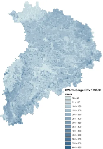
catch-GW-Recharge HBV 1990-99 mm/a 30 - 50 51 - 100 101 - 150 151 - 200 201 - 250 251 - 300 301 - 350 351 - 400 401 - 450 451 - 500 501 - 550 551 - 600 601 - 650
Fig. 3. Mean annual groundwater recharge in the Neckar basin sim-ulated with HBV.
ment varies from 93 m a.s.l at the catchment outlet to about 1022 m a.s.l in the Schw¨abische Alb in the south of the catch-ment (Fig. 1). The climate can be characterized as humid with a long-term average annual precipitation of 950 mm, ranging from 750 mm in the lower part to over 1200 mm in the Black Forest. Landuse (Landsat 1993, resolution 30 m), soil (Boden¨ubersichtskarte 200, scale 1:200 000) and topo-graphic data (resolution 50 m) were aggregated to a uniform grid resolution (1 km). Precipitation and temperature data were interpolated by external drift kriging from observation station data. Discharge data from 58 gauging stations was used for model evaluation. All data was provided by the State Institute for Environmental Protection Baden-W¨urttemberg.
4 Integration methodology
Figure 2 visualizes the selected integration strategy: Soil, to-pographic, land use and climatic data provide the parameters and driving forces of the hydrological model, which calcu-lates discharge components and high resolution groundwater recharge rates. The latter serve as input for the groundwater
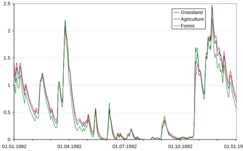
88 J. G¨otzinger et al.: Integration of water balance models in RIVERTWIN 0 0.5 1 1.5 2 2.5 01.01.1992 01.04.1992 01.07.1992 01.10.1992 01.01.1993 Grassland Agriculture Forest
Fig. 4. Seasonal variation of groundwater recharge (mm/d) of three land use types simulated with HBV.
0 1 2 01.01.1997 01.01.1998 Date 01.01.1999 01.01.2000 D ischar ge [m 3/s] Qb MODFLOW Qb HBV Qb LARSIM
Fig. 5. Simulated groundwater runoff hydrographs of MODFLOW, HBV and LARSIM at Neuenstadt (1997–1999).
model which simulates, in addition to the groundwater lev-els, groundwater runoff in the stream network, which is used in the hydrological model as the groundwater component of the discharge. Capillary rise from the groundwater to the root zone is negligible on this scale in the Neckar basin and is therefore not included in the model integration. The simu-lated total discharge serves as input to water quality, ecologi-cal and water supply models. In contrast to the water balance models, no feedback is included between these models.
All models were calibrated individually. Both hydrologi-cal models were hydrologi-calibrated to fit the observed discharges and to provide a realistic estimate of groundwater recharge. The groundwater model was calibrated to fit the groundwater lev-els as well as to minimize the difference between the
ground-water runoff simulated by the groundground-water model and the hydrologic models. Including this groundwater runoff in the hydrologic model decreases the simulation efficiency of the total discharge. Nevertheless, the additional constraints on the individual models (groundwater recharge and groundwa-ter runoff) reduce the degrees of freedom of the system which leads to lower model efficiency but increased confidence in the model structure and parameters.
5 Results
The simulation of groundwater recharge with HBV shows a high spatial variability, determined by climate, land use and soil type (Fig. 3). The seasonal variability, shown in
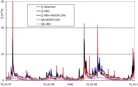
0 10 20 30 01.01.97 01.01.98 Date 01.01.99 01.01.00 Q [m 3/s] Q observed Q HBV Q HBV+MODFLOW Qb MODFLOW Qb HBV
Fig. 6. Observed and simulated discharge at Neuenstadt (1997–1999), red: observation, blue: HBV, black: direct runoff from HBV plus groundwater runoff from MODFLOW, magenta: groundwater runoff simulated with MODFLOW, green: groundwater runoff simulated with HBV. 0 10 20 30 01.01.97 01.01.98 Date 01.01.99 01.01.00 Q [m 3/s] Q observed Q LARSIM Q LARSIM+MODFLOW Qb MODFLOW Qb LARSIM
Fig. 7. Observed and simulated discharge at Neuenstadt (1997–1999), red: observation, blue: LARSIM, black: direct runoff from LARSIM plus groundwater runoff from MODFLOW, magenta: groundwater runoff simulated with MODFLOW, green: groundwater runoff simulated with LARSIM.
Fig. 4 for three distinct land use types with similar soil prop-erties, is also quite high due to fluctuations in rainfall and evaporative demand. This groundwater recharge was used in MODFLOW to model the groundwater levels and runoff to the river system.
The groundwater runoff hydrographs simulated with MODFLOW, HBV and LARSIM display a similar magni-tude and variability (Fig. 5). The simulated groundwater runoff hydrographs of LARSIM and particularly of HBV are systematically higher and more delayed than the MOD-FLOW hydrographs. As expected from a physically based
model, MODFLOW shows a much more dynamic response than the linear reservoir models HBV and LARSIM. The dif-ferences between the two hydrological models stem from the varying separation into direct runoff and groundwater recharge. All three results are plausible compared to base flow separation methods, literature values and process under-standing, and could be accepted since the true groundwater runoff cannot be measured directly on this scale. In fact, it is only a conceptual quantity that is always defined with respect to a certain context and scale. As the simulated discharge in this integrated model is used for river basin management,
90 J. G¨otzinger et al.: Integration of water balance models in RIVERTWIN the groundwater runoff must primarily serve this purpose.
This means that the groundwater runoff should fit well to the other simulated flow components. The hydrographs of the total discharge show that, especially in the low flow periods, the groundwater contribution influences the discharge signif-icantly (Fig. 6 and Fig. 7). The Nash-Sutcliffe model effi-ciency of the HBV simulations is 0.55 compared to 0.73 for LARSIM. In some cases the integration of the groundwater model baseflow even increased the model efficiency (HBV: 0.58 in the integrated model compared to 0.55 in the original simulations). But in most cases it led to a reduced Nash Sut-cliffe coefficient (LARSIM: 0.67 compared to 0.73). Never-theless, the loss in accuracy is acceptable given the additional information that becomes available through the integration.
6 Conclusions
The integration of a hydrological and a groundwater model has shown that groundwater presents a significant contribu-tion to the water balance of the Neckar catchment, espe-cially in low flow periods. The use of simulated groundwa-ter recharge as input to the groundwagroundwa-ter model demonstrated that hydrological models can provide realistic estimations of this inflow to the groundwater system. The groundwa-ter runoff simulated with a groundwagroundwa-ter model reacted fasgroundwa-ter and was smaller than the one simulated with the two hydro-logical models. Theory and other studies indicate that, even on this scale, groundwater flow can be simulated with more reliance by a physical groundwater model than a conceptual linear storage reservoir (Rojanschi et al., 2006). Integrat-ing these models, however, extends the demands on them but also the possibilities to verify the model concepts. De-spite reduced simulation efficiency, this improved our trust in the models for the simulation of future climate or land use change impact scenarios. The presented examples have shown that model integration on the meso-scale is possible but brings up new problems which are currently being ad-dressed in more detail. But it also opens up possibilities to improve models by multi-response validation and provides helpful insights into internal processes and model concep-tualizations. The model integration is currently being im-proved and will then be used to simulate the impact of land use and climate change scenarios on the water balance of the Neckar catchment.
Acknowledgements. This research was funded by the European
Union in the Sixth Framework Program through the project RIVERTWIN. Data and the model LARSIM were provided by the State Institute for Environmental Protection Baden-W¨urttemberg. The valuable suggestions of two reviewers are greatly appreciated. Edited by: R. Barthel, J. G¨otzinger, G. Hartmann, J. Jagelke,
V. Rojanschi, and J. Wolf Reviewed by: anonymous referees
References
Barthel, R., Rojanschi, V., Wolf, J., and Braun, J.: Large-scale water resources management within the framework of GLOWA-Danube, Part A: The groundwater model, Phys. Chem. Earth, 30, 6–7, 372–382, 2005.
Bergstr¨om, S.: The HBV model, in: Computer Models of Water-shed Hydrology, edited by: Singh, V. P., Water Resources Pub., Littleton, CO, 443–476, 1995.
Beven, K. J. and Binley, A. M.: The future of distributed models: model calibration and uncertainty prediction, Hydrol. Processes, 6, 279–298, 1992.
Bronstert, A., Carrera, J., Kabat, P., and L¨utkemeier, S.: Coupled models for the hydrological cycle, Springer, Heidelberg, Ger-many, 2005.
Bremicker, M.: Das Wasserhaushaltsmodell LARSIM – Modell-grundlagen und Anwendungsbeispiele, Institut f¨ur Hydrologie der Universit¨at Freiburg, Freiburg, Germany, 2000.
Bremicker, M. and Gerlinger, K.: Operational application of the water balance model LARSIM in the Neckar basin, Institut f¨ur Hydrologie der Universit¨at Freiburg, Freiburg, Germany, 2000. Gaiser, T., Ara´ujo, J. C., Frischkorn, H., and Krol, M. (Eds.): Global
Change and Regional Impacts: Water Availability and Vulner-ability of Ecosystems and Society in Semi-Arid Northeast of Brazil, Springer, Heidelberg, Germany, 2003.
G¨otzinger, J. and B´ardossy, A.: Integration and calibration of a con-ceptual rainfall-runoff model in the framework of a decision sup-port system for river basin management, Adv. Geosci., 5, 1–5, 2005,
http://www.adv-geosci.net/5/1/2005/.
Hundecha, Y. and B´ardossy, A.: Modeling of the effect of land use changes on the runoff generation of a river basin through pa-rameter regionalization of a watershed model, J. Hydrol., 292, 281–295, 2004.
Hundecha, Y.: Regionalization of Parameters of a Conceptual Rainfall-Runoff Model, Mitteilungsheft Nr. 142, Institut f¨ur Wasserbau der Universitaet Stuttgart, Stuttgart, Germany, 2005. K¨am¨ari, J.: BMW – Benchmark Models for the
Wa-ter Framework Directive http://www.environment.fi/default.asp? contentid=116046\&lan=EN\#a1, 09.01.2006.
Kuczera, G. and Mroczkowski, M.: Assessment of hydrologic pa-rameter uncertainty and the worth of multiresponse data, Water Resour. Res., 34, 6, 1481–1489, 1998.
McDonald, M. G. and Harbaugh, A. W.: A modular three-dimensional finite-difference ground-water flow model, Techni-cal report, U.S. Geol. Survey, Reston, VA. USA, 1988.
Refsgaard, J. C. (Ed.): State-of-the-art report on quality assurance in modelling related to river basin management, HarmoniQuA Report, D-WP1-1, Copenhagen, Denmark, 2002.
Rojanschi, V., Wolf, J., and Barthel, R.: Calibration and Valida-tion of an Integrated Hydrological Model Complex in the Ammer Catchment, Adv. Geosci., this volume, 2006.
Seibert, J.: Multi-criteria calibration of a conceptual runoff model using a genetic algorithm, Hydrol. Earth Syst. Sci., 4(2), 215– 224, 2000.
Singh, V. P. (Ed.): Computer Models of Watershed Hydrology, Wa-ter Resour. Publ., Littleton, Colorado, USA. 1995.
Stock, M. (Ed.): KLARA Klimawandel – Auswirkungen, Risiken, Anpassung, PIK Report No. 99, Potsdam, Germany, 2005.
Uhlenbrook, S., Seibert, J., Leibundgut, C., and Rohde, A.: Predic-tion uncertainty of conceptual rainfall-runoff models caused by problems in identifying model parameters and structure, Hydrol. Sci. J., 44(5), 779–797, 2004.
Zhao, R. J.: Flood forecasting method for humid regions in China, East China Institute of Hydraulic Engineering, Nanjing, China, 1977.
Zehe, E. and B´ardossy, A.: Hydrological Impact of Climate Change on the River Rhine, Final report, in: IRMA-SPONGE “Develop-ment of flood manage“Develop-ment strategies for the Rhine and Meuse basins in the context of integrated river management” University of Stuttgart, Germany 2002.