controls on catchment dynamics and their
implications for low flows
Thesis submitted at the
Faculty of Sciences
Centre for Hydrogeology and Geothermics (CHYN)
University of Neuchˆatel
for the degree of
Doctor of Sciences
presented by
Claire Carlier
Accepted by the following evaluation committee:
Prof. Philip Brunner, University of Neuchˆatel (Switzerland), director of thesis Prof. Daniel Hunkeler, University of Neuchˆatel (Switzerland), co-director of thesis
Dr. Stefanie Wirth, University of Neuchˆatel (Switzerland) Dr. Ronald Kozel, Federal Office For the Environment (Switzerland)
Prof. Alain Dassargues, University of Li`ege (Belgium)
University of Neuchˆatel Defended on March 28th, 2018
2000 Neuchâtel – Suisse Tél : + 41 (0)32 718 21 00 E-mail : [email protected]
IMPRIMATUR POUR THESE DE DOCTORAT
La Faculté des sciences de l'Université de Neuchâtel
autorise l'impression de la présente thèse soutenue par
Madame Claire CARLIER
Titre:
“Hydrogeological and topographical
controls on catchment dynamics and
their implications for low flows”
sur le rapport des membres du jury composé comme suit:
• Prof. Philip Brunner, directeur de thèse, Université de Neuchâtel, Suisse • Prof. Daniel Hunkeler, co-directeur de thèse, Université de Neuchâtel, Suisse • Dr Stefanie Wirth, Université de Neuchâtel, Suisse
• Dr Ronald Kozel, OFEV, Ittigen, Suisse
• Prof. Alain Dassargues, Université de Liège, Belgique
Remerciements
Je tiens `a remercier les personnes avec qui j’ai eu le plaisir de collaborer dans le cadre de cette th`ese et du projet “low flow”. Un immense merci `a Philip Brunner pour son soutien scientifique, son encadrement solide, sa confiance et surtout son enthousiasme rayonnant. Sans oublier ses sorties humoristiques piquantes et ses conseils de lecture (non scienti-fiques). Je remercie ´egalement Daniel Hunkeler pour son implication dans le projet et pour ses id´ees, qui ont sensiblement fac¸onn´e ce travail. Un grand merci `a Stefanie Wirth pour ses conseils et pour l’´elan g´eologique qu’elle a apport´e au projet. Je remercie Fabien Cochand, ˆo grand maˆıtre du “.grok” et coll`egue en or, pour le coaching HGS et sportif ainsi que pour ses mots d’encouragement (“lˆache pˆo” ou “abandonne”, selon l’humeur). Danke aux hy-drologues de Freiburg (Michael St¨olzle, Kerstin Stahl, Joscha Feuerstein) et de Zurich (Jan Seibert, Maria Staudinger) pour les nombreuses discussions int´eressantes. Je remercie tout particuli`erement Maria, que j’ai beaucoup appr´eci´e cˆotoyer, pour son implication dans le projet. Mille grazie `a Davide Caragnini, dont j’ai eu le plaisir de suivre le travail de master et qui m’a permis de m’´eloigner de mon ordinateur pour d´ecouvrir de nouvelles m´ethodes de terrain (d’ailleurs, merci `a Pierik Falco pour la g´eophysique). Je remercie Roberto pour son aide sur le terrain et pour sa bonne humeur. Merci beaucoup `a Carine et Corinne pour leur soutien administratif au secr´etariat. Un grand merci `a Oliver Schilling, qui m’a prise sous son aile `a mon arriv´ee au CHYN, pour son aide avec HGS et sur le terrain, et surtout avec qui j’ai appris le suisse allemand. Je remercie chaleureusement les membres externes du jury, Alain Dassargues et Ronald Kozel, d’avoir pris la peine de lire cette th`ese, pour leurs commentaires et pour les riches discussions suite `a la d´efense. Merci aux membres de l’OFEV, et tout particuli`erement `a Petra Schmocker-Fackel et Michael Sinreich, pour leur suivi du projet et leurs suggestions r´eguli`eres. Merci encore `a Wolfgang Kinzelbach qui m’a orient´ee vers cette th`ese.
Merci `a tous les amis, coll`egues et ´etudiants du CHYN qui ont contribu´e indirectement `a m’inspirer dans cette quˆete du Graal, `a coup d’activit´es diverses, de pauses caf´e ensoleill´ees, d’ap´eros, de discussions dans le couloir, etc. Chapeau bas `a mes colocataires successifs du bureau E313, Lucien et James, pour m’avoir support´ee (dans le sens franc¸ais du terme ainsi que l’anglicisme) pendant plusieurs ann´ees. Merci `a C´ecile, Violaine, Lorienne, Vincent, Greg, Guigui, C´elia, Clara, Marion, Marie-Louise, Guillaume G., Paco, Nico, L´ea, Philippe W., Christophe, Jeremy, Gunnar, Reza et tous les autres (il faut bien s’arrˆeter quelque part !), grˆace `a qui aller au boulot a ´et´e un plaisir (presque) tous les matins pendant quatre ans. Je remercie ma famille et mes amis pour la perfusion continuelle de motivation et l’´elaboration d’aspirations extrascientifiques. Merci `a Manu, les colocs de Berne, Genevi`eve et Marie pour les bons moments du quotidien.
Summary
Periods with scarce precipitation will likely occur more frequently and last longer under changing climatic conditions, even in relatively humid regions like Switzerland. To assess the sensitivity of water resources to dry spells and to identify regions that might experience water scarcity issues, a thorough understanding of the mechanisms governing catchment dynamics in the absence of rain is essential. During dry periods, streamflow is mainly fed by groundwater reservoirs and thus reflects the ability of the catchment to release water that has been previously stored during precipitation events. Catchment characteristics that govern groundwater processes are consequently inherent to low-flow dynamics. The sensitivity of catchments to dry periods thus has to be assessed from a hydrogeological perspective.
This PhD thesis, with the global aim of providing tools for the identification of catch-ments sensitive to dry conditions, explores the physiographic controls on catchment dynam-ics with emphasis on low flows and on the role of hydrogeological factors. Previous studies dedicated to the relationship between catchment properties and streamflow dynamics often disregard the subsurface characteristics. Moreover, unravelling the various physical con-trols on hydrological signatures is complex based on observed data. To cope with these limitations, two approaches are developed: (1) the use of hydrogeological synthetic mod-els, which allow the systematic assessment of topographical and hydrogeological influence on low flows and groundwater storage, and (2) an investigation of streamflow dynamics of 22 Swiss catchments with the consideration of detailed geological and hydrogeological descriptors of both the general geological environment (bedrock lithologies) and alluvial quaternary aquifers.
In the first approach, catchment hydrogeological and topographical features (bedrock and alluvial hydraulic conductivity, hillslope and river slope) are systematically varied us-ing the numerical model HydroGeoSphere. This software simulates surface and subsurface flow in a fully coupled, distributed way. It thus allows the explicit consideration of ground-water processes and the quantification of the impact of each physical property on catch-ment dynamics. The synthetic models provide great insights on the relationship between low flows and groundwater processes, on the relative importance of the bedrock and the alluvial aquifer, and on the combined impact of hydraulic conductivity and slope gradients. Moreover, the role of catchment properties whose observation in the field is bound to high uncertainties, such as the hydraulic conductivity of the bedrock, can be explored with the synthetic models. The only catchment property exerting an overall impact on low flows is indeed the hydraulic conductivity of the bedrock. Relatively high hydraulic conductivities (e.g. 10-6m/s to 10-5m/s) of the bedrock guarantee sustained low flows. Depending on this value, the contribution of the bedrock to low flows can be increased respectively dimin-ished by steep respectively flat hillslopes. When the capacity of the bedrock to sustain the stream (quantified by the proposed bedrock productivity index BPI) is limited, the relative contribution of the alluvial aquifer can become significant.
In the second approach, the catchment properties of the 22 selected catchments, encom-passing land use, soil, topography and geology, as well as precipitation characteristics, are compared to numerous streamflow indicators describing the entire range of dynamics over 20 years. Absolute (e.g. Q95 to Q5) as well as relative indicators (e.g. Q95 divided by mean discharge) are used. The normalisation of the discharge indicators filters the influence of precipitation, which allows focusing on the impact of catchment properties on discharge dynamics. The meteorological and the catchment controls on hydrological signatures thus become distinguishable. The impact of precipitation is consequent on the absolute dis-charge indicators except for the low-flow range. The relative indicators, which describe both high and low normalised discharges, are however only correlated to the geological properties of the catchments (% of sandstone and % of productive quaternary deposits). The ability of the catchment to “buffer” the precipitation signal can thus be attributed to its geological and hydrogeological characteristics. The results suggest that this “stabilisation” effect on streamflow, quantified for instance by Q95/Qmean, is sustained by the presence of sandstone in the catchment. Moreover, productive quaternary deposits with a large extent or volume also seem to have a favourable effect on normalised low flows.
The two approaches are complementary and enable to identify similar processes and governing mechanisms, which are of high relevance for the characterisation of catchment and of low-flow dynamics. According to both approaches, a relatively permeable bedrock (e.g. 10-5m/s, sandstone) is a prerequisite for sustained streamflow during dry periods. The influence of local productive deposits on catchment dynamics is also highlighted by both methods. Based on these findings, two guidelines are developed to assess the sensitivity of rivers and alluvial aquifers to dry periods. The assessment can be quantitative if adequate time series and data describing the resource exist, whereas it has a qualitative value if scarce discharge or groundwater head data are available. In the latter case, monitoring strategies can for instance be established on the basis of this guideline. Furthermore, it provides a framework for catchment inter-comparison with regards to their behaviour under dry conditions.
Keywords : streamflow dynamics, groundwater, low flows, numerical modelling, geo-logy, topography
R´esum´e
Mˆeme dans des r´egions relativement humides comme la Suisse, des p´eriodes de s´echeresses plus intenses et prolong´ees sont attendues `a cause des changements climatiques. Afin d’appr´ehender la sensibilit´e des ressources en eaux aux s´echeresses et d’identifier les r´egions `a risque, une compr´ehension profonde des m´ecanismes gouvernant la dynamique des bassins versant en l’absence de pr´ecipitation est cruciale. Pendant les p´eriodes de s´echeresses, les rivi`eres sont principalement aliment´ees par l’eau souterraine. Leur d´ebit refl`ete donc la capacit´e du bassin versant `a lib´erer de l’eau stock´ee lors de pr´ec´edents ´ev´enements pluvieux. Les caract´eristiques des bassins versants qui influencent les proces-sus hydrog´eologiques sont ainsi inh´erents `a leur dynamique de basses eaux. La sensibilit´e des bassins versants doit donc ˆetre ´evalu´ee d’une perspective hydrog´eologique.
Afin de d´evelopper des outils pour l’identification des ressources en eaux sensibles aux s´echeresses, cette th`ese de doctorat explore les influences des propri´et´es physiogra-phiques sur la dynamique des bassins versants, en mettant l’accent sur leur comportement de basses eaux et sur le rˆole de l’hydrog´eologie. Les pr´ec´edentes ´etudes consacr´ees au lien entre les propri´et´es physiques des bassins versant et leur dynamique n´egligent sou-vent leurs caract´eristiques souterraines. De plus, l’identification des effets de chaque pro-pri´et´e physique sur le comportement hydrologique des bassins reste complexe. Afin de contrer ces limites, deux approches sont d´evelopp´ees : (1) l’utilisation de mod`eles hy-drog´eologiques synth´etiques permettant d’´evaluer syst´ematiquement l’influence des pa-ram`etres hydrog´eologiques et topographiques sur les basses eaux, et (2) l’´etude de la dyna-mique hydrologique de 22 bassins versants suisses avec la prise en consid´eration d´etaill´ee de leurs caract´eristiques g´eologiques et hydrog´eologiques (roche en place ou coh´erente – “bedrock” en anglais – et d´epˆots quaternaires).
Dans le cadre de la premi`ere approche, les propri´et´es hydrog´eologiques et topogra-phiques des bassins (conductivit´e hydraulique de la roche en place et de l’aquif`ere alluvial, pente des versants et de la rivi`ere) sont vari´ees syst´ematiquement avec HydroGeoSphere. Ce mod`ele num´erique et distribu´e simule de mani`ere coupl´ee et simultan´ee les flux souterrains et de surface. Ainsi, les processus hydrog´eologiques sont consid´er´es explicitement et l’im-pact de chaque propri´et´e physique sur la dynamique des bassins versants peut ˆetre quantifi´e. Ces mod`eles synth´etiques b´en´eficient grandement `a la caract´erisation : du lien entre dyna-miques de basses eaux et de l’eau souterraine, de l’importance relative de la roche en place et des d´epˆots alluviaux, et de l’influence combin´ee de la conductivit´e hydraulique et de la topographie. En outre, le rˆole de propri´et´es difficilement mesurables sur le terrain, comme la perm´eabilit´e de la roche en place (p.ex. la Molasse en Suisse), peut ˆetre ´etudi´e. Cette caract´eristique est d’ailleurs la seule `a exercer un effet global sur les basses eaux de tous les bassins synth´etiques. Une conductivit´e relativement haute (p.ex. 10-6m/s `a 10-5m/s) de la roche en place garantit des debits de basses eaux importants. En fonction de cette valeur, la contribution de la roche en place aux basses eaux peut ˆetre favoris´ee par des versants raides
ou diminu´ee par un relief limit´e. Lorsque la capacit´e de la roche en place `a subvenir aux bas d´ebits est limit´ee (quantifi´ee par le bedrock productivity index BPI), la contribution relative de l’aquif`ere alluvial peut devenir significative.
Dans la seconde approche, les propri´et´es physiques des 22 bassins versants suisses s´electionn´es (utilisation et types de sol, topographie, g´eologie et param`etres m´et´eorologiques) sont compar´ees `a une multitude d’indicateurs hydrologiques d´ecrivant toutes les gammes de d´ebits sur 20 ans de mesure. Des indicateurs de d´ebits absolus (p.ex. Q95 `a Q5) ainsi que des indicateurs relatifs (p.ex. Q95 divis´e par le d´ebit moyen) sont uti-lis´es. La normalisation des indacteurs de d´ebit permet de filtrer l’effet des pr´ecipitations et donc de se concentrer sur l’influence des propri´et´es physiques du bassin sur sa dynamique. Ainsi, les effets de la pr´ecipitation et des param`etres physiques sur le comportement hy-drologique deviennent distinguables. Les indicateurs absolus de d´ebit, `a part les bas d´ebits, d´ependent principalement de la m´et´eorologie. Les indicateurs relatifs, d´ecrivant tout autant les bas que les hauts d´ebits relatifs, sont en revanche uniquement corr´el´es aux param`etres g´eologiques et hydrog´eologiques des bassins (% de gr`es, % de d´epˆots quaternaires produc-tifs). La capacit´e d’un bassin versant d’“amortir” le signal de la pr´ecipitation peut donc ˆetre attribu´ee `a ses caract´eristiques g´eologiques et hydrog´eologiques. Les r´esultats sugg`erent que ce potentiel de “stabilisation” des d´ebits, quantifi´e par exemple par le ratio Q95/Qmean, est favoris´e par la pr´esence de gr`es dans le bassin. De plus, des d´epˆots quaternaires impor-tants semblent ´egalement exerc´e un effet positif sur les bas d´ebits normalis´es.
Les deux approches sont compl´ementaires et permettent d’identifier des processus similaires, cruciaux pour la caract´erisation de la dynamique g´en´erale et de basses eaux des bassins versants. Selon les deux lignes de recherche, une roche en place relativement perm´eable (p.ex. 10-5m/s, du gr`es) est un pr´erequis pour des d´ebits soutenus lors de p´eriodes s`eches. L’influence de d´epˆots productifs locaux sur la dynamique des bassins est soulign´ee par les deux approches. Sur la base de ces r´esultats, deux aides `a l’´evaluation de la sensibilit´e des rivi`eres et des aquif`eres alluviaux aux s´echeresses sont d´evelopp´ees. Les m´ethodes d´ependent du type et de la qualit´e des donn´ees disponibles. Si celles-ci sont suffisantes, l’estimation de la sensibilit´e peut ˆetre quantitative, alors qu’elle a une valeur qualitative si les donn´ees de d´ebits ou de hauteurs pi´ezom´etriques sont rares. Dans le second cas, des strat´egies de surveillance des ressources en eaux peuvent notamment ˆetre ´etablies sur la base des lignes directives propos´ees. En outre, celles-ci proposent un cadre de comparaison du comportement des bassins versants en p´eriode s`eche.
Mots cl´es : dynamique des d´ebits des rivi`eres, eau souterraine, basses eaux, mod`eles num´eriques, g´eologie, topographie
Zusammenfassung
L¨angere und h¨aufigere Trockenheitsperioden sind aufgrund der Klima¨anderung auch in re-lativ feuchten Regionen wie der Schweiz zu erwarten. Um die Sensitivit¨at von Wasserres-sourcen bez¨uglich Trockenzeiten zu bestimmen, sowie um Risikoregionen zu identifizie-ren, ist ein gr¨undliches Verst¨andnis der Dynamik von Einzugsgebieten w¨ahrend trockenen Perioden deshalb unverzichtbar. In Trockenzeiten werden Fl¨usse haupts¨achlich von Grund-wasserspeichern gespeist. Niedrigabfl¨usse spiegeln also die F¨ahigkeit eines Einzugsgebiets wider Wasser abzugeben, welches w¨ahrend vorheriger Regenereignisse gespeichert wurde. Die physikalischen Charakteristiken, die Grundwasserprozesse beeinflussen, sind dement-sprechend von hoher Relevanz f¨ur die Niedrigwasserdynamik. Die Empfindlichkeit von Einzugsgebiete gegen¨uber Trockenzeiten sollte demnach aus einer hydrogeologischen Per-spektive bewertet werden.
Das ¨ubergreifende Ziel dieser Doktorarbeit ist die Entwicklung von Ans¨atzen f¨ur die Identifizierung von Einzugsgebieten, die empfindlich auf Trockenperioden reagieren. Daf¨ur werden die Einfl¨usse von physiographischen Eigenschaften auf die Abfluss- und Grund-wasserdynamik untersucht, unter dem Schwerpunkt des Niedrigwasserverhaltens und der Rolle hydrogeologischer Faktoren. Die hydrogeologischen Charakteristiken wurden in bis-herigen Studien ¨uber den Zusammenhang zwischen Einzugsgebietseigenschaften und Ab-flussdynamik oft vernachl¨assigt. Außerdem sind die Einfl¨usse der hydrogeologischen, topo-graphischen und klimatischen Eigenschaften auf die Abflussdynamik komplex. Die folgen-den zwei Ans¨atze sind angewandt: (1) die Ben¨utzung von synthetischen hydrogeologischen Modellen, die die systematische Bewertung von topographischen und hydrogeologischen Einfl¨ussen auf den Niedrigwasserabfluss und die Grundwasserspeicherung erlauben, und (2) die Untersuchung der hydrologischen Dynamik von 22 schweizerischen Einzugsgebie-ten, welche die Geologie (Molasse und quart¨are Ablagerungen) und die Hydrogeologie detailliert betrachtet.
Im ersten Ansatz werden mit dem numerischen Modell HydroGeoSphere die hydrogeo-logischen und topographischen Parameter der Einzugsgebiete (hydraulische Leitf¨ahigkeit vom Festgestein und vom alluvialen Aquifer, Hang- und Flussneigung) systematisch va-riiert. Mit dieser Software werden die oberfl¨achlichen und unterirdischen Fl¨usse physika-lisch gekoppelt und r¨aumlich verteilt simuliert. Dementsprechend sind die Grundwasser-prozesse explizit ber¨ucksichtigt und der Einfluss von jeder physikalischen Eigenschaft auf die Einzugsgebietsdynamik kann bestimmt werden. Die synthetischen Modelle sind be-sonders informativ um den Zusammenhang zwischen Niedrigwasserverhalten und Grund-wasserprozessen besser zu verstehen, um die relative Wichtigkeit von Festgestein und von alluvialen Ablagerungen zu bewerten, sowie um den kombinierten Effekt von hydrauli-scher Leitf¨ahigkeit und Topographie besser zu beurteilen. Ausserdem kann die Rolle von schwierig messbaren Eigenschaften wie die hydraulische Leitf¨ahigkeit des Festgesteins un-tersucht werden. Die synthetischen Modelle zeigen, dass die hydraulische Leitf¨ahigkeit des
Festgesteins n¨amlich einen ¨ubergreifenden Einfluss auf das Niedrigwasserverhalten aus¨ubt. Relativ hohe hydraulische Leitf¨ahigkeiten (z.B. 10-6m/s to 10-5m/s) gew¨ahrleisten stabile Niedrigwasserabfl¨usse. In Abh¨angigkeit der hydraulische Leitf¨ahigkeit kann der Grund-wasserbeitrag des Festgesteins w¨ahrend Niedrigwasserbedingungen wegen steilen bzw. fla-chen Hangneigungen erh¨oht bzw. erniedrigt werden. Falls das Festgestein nur bedingt zum Oberfl¨achenabfluss beitr¨agt (quantifiziert mit den vorgeschlagenen bedrock productivity in-dex BPI), kann der Beitrag des alluvialen Aquifers von Wichtigkeit sein.
Im zweiten Ansatz werden die Eigenschaften (Landnutzung, Boden, Topographie, Geologie sowie Niederschlagsdaten) der 22 ausgew¨ahlten Einzugsgebiete mit zahlreichen Abflussindikatoren verglichen, welche die Abflussdynamik ¨uber einen Zeitraum von 20 Jahre beschreiben. Absolute Abflussindikatoren (z.B. Q95 bis Q5) sowie relative Ab-flussverh¨altnisse (z.B. Q95 dividiert durch mittleren Abfluss) werden benutzt. Die Norma-lisierung der Indikatoren erlaubt es, den Einfluss des Niederschlags herauszufiltern, um auf der Rolle der Einzugsgebietseigenschaften zu fokussieren. Dadurch werden die Effekte des Niederschlags und der physikalischen Eigenschaften auf die Abflussdynamik unterscheid-bar. Die meisten absoluten Abflussindikatoren, mit Ausnahme der Niedrigwasserabfl¨usse, werden haupts¨achlich vom Niederschlag bestimmt. Hingegen sind die relativen Indikatoren, die sowohl die Niedrig- sowie die Hochwasserverh¨altnisse beschreiben, nur zu den geolo-gischen Eigenschaften (% Sandstein und % produktiven Quart¨arablagerungen) korreliert. Die F¨ahigkeit eines Einzugsgebiets, das Niederschlagssignal zu “d¨ampfen”, kann demnach auf seine geologischen und hydrogeologischen Charakteristiken zur¨uckgef¨uhrt werden. Die Resultate zeigen, dass diese “Stabilisierung” der Abflussdynamik, quantifiziert z.B. mit Q95/Qmean, stark von der Anwesenheit von Sandstein im Einzugsgebiet bestimmt wird. Ausserdem haben ergiebige und weitverbreitete Quart¨arablagerungen auch einen positiven Einfluss auf die relativen Niedrigwasserabfl¨usse.
Die zwei Ans¨atze erg¨anzen sich und erlauben es, Prozesse zu identifizieren, die f¨ur die Charakterisierung der Niedrigwasserdynamik in einem Einzugsgebiet grundlegend sind. Beide Ans¨atze zeigen, dass ein relativ durchl¨assiges Festgestein (z.B. 10-5m/s, Sandstein im zweiten Ansatz) eine Voraussetzung f¨ur hohe Niedrigabfl¨usse ist. Der Einfluss von er-giebigen alluvialen oder Quart¨arablagerungen auf Einzugsgebietsdynamik wird auch durch die beiden Ans¨atze bestimmt. Darauf basierend werden zwei Richtlinien zur Bestimmung der Empfindlichkeit von Fl¨ussen und alluvialen Aquiferen bez¨uglich Trockenperioden entwickelt. Die vorgeschlagenen Methoden h¨angen von der Datenverf¨ugbarkeit ab. Falls ausreichend Daten zu Oberfl¨achenabfluss und Grundwasserst¨anden vorhanden sind, kann die Bestimmung der Empfindlichkeit quantitativ sein. In Abwesenheit solcher Daten ist diese Einsch¨atzung qualitativ. Im zweiten Fall k¨onnen basierend auf der Richtlinien Moni-toringstrategien entwickelt werden. Ausserdem stellen diese Richtlinien einen Rahmen f¨ur den Vergleich des Verhaltens von Einzugsgebieten unter trockenen Bedingungen dar.
Schl ¨usselbegriffe: Abflussdynamik, Grundwasser, Niedrigwasser, numerische Model-le, Geologie, Topographie
1 Introduction 1
1.1 Context . . . 1
1.1.1 The “Low flow” project . . . 2
1.2 Physical processes . . . 4
1.3 Literature review . . . 5
1.3.1 Studies relating stream dynamics and catchment properties . . . 5
1.3.2 Studies relating groundwater dynamics and catchment properties . . 7
1.4 Methodology and structure of the thesis . . . 8
2 Exploring geological and topographical controls on low flows with hydrogeolo-gical models 11 2.1 Introduction . . . 13
2.2 Methods . . . 15
2.2.1 Numerical model and data analysis . . . 15
2.2.2 Catchment configuration . . . 15
2.2.3 Experimental design . . . 17
2.2.4 Mesh and simulation specifications . . . 19
2.2.5 Low-flow and groundwater dynamics indicators . . . 20
2.3 Results . . . 21
2.3.1 Low flows and groundwater storage dynamics . . . 21
2.3.2 Identification of controlling properties on low flows . . . 23
2.3.3 Influence of hydraulic and geometrical characteristics . . . 25
2.3.4 Bedrock productivity index (BPI) . . . 27
2.3.5 Bedrock and alluvial valley aquifer . . . 28
2.4 Discussion . . . 30
2.4.1 Applicability of the synthetic model approach . . . 30
2.4.2 Influence of the hydraulic conductivity of the bedrock . . . 31
2.4.3 Influence of topography . . . 31
2.4.4 Bedrock productivity index BPI . . . 32
2.5 Conclusions and implications . . . 33
3 Assessment of catchment controls on streamflow dynamics: the importance of geology 37 3.1 Introduction . . . 39
3.2 Method and catchment characteristics . . . 42
3.2.1 Catchment selection . . . 42
3.2.2 Topography . . . 46
3.2.3 Soil and land use . . . 46
3.2.4 Geology and hydrogeology . . . 46
3.2.5 Precipitation and evapotranspiration . . . 47
3.2.6 Discharge . . . 47
3.2.7 Water balances . . . 48
3.3 Results . . . 50
3.3.1 Analysis of interdependency among catchment properties and met-eorological conditions . . . 50
3.3.2 Relationship between streamflow signature and catchment and met-eorological properties . . . 50
3.4 Discussion . . . 58
3.4.1 Climate and catchment controls on streamflow dynamics . . . 58
3.4.2 The influence of geology on the buffering potential of catchments . 60 3.4.3 Buffering potential and dynamic storage: a groundwater perspective 62 3.4.4 Importance of other catchment properties for streamflow dynamics . 63 3.5 Conclusions and implications . . . 64
3.5.1 Implications for hydrological sciences . . . 64
3.5.2 Implications for water resources management and data acquisition . 65 4 Implications for catchment sensitivity to dry periods 67 4.1 Comparison of findings of Chapters 2 and 3 . . . 67
4.1.1 Dynamic groundwater storage and buffering potential of the catch-ment . . . 68
4.1.2 The role of geology and the relative importance of the bedrock and the alluvial deposits . . . 69
4.1.3 The role of topography . . . 70
4.1.4 The configuration of the outlet . . . 70
4.2 Application to the assessment of the sensitivity of water resources to dry periods . . . 70
4.2.1 Assessment of streamflow sensitivity to dry periods . . . 71 4.2.2 Assessment of the sensitivity of an alluvial aquifer to dry periods . 75
5 Conclusion 79 5.1 Implications for practice . . . 80 5.1.1 Suggestions for data acquisition . . . 81 5.2 Implications for further research . . . 82
Bibliography 85
A Parameters and main outputs of the synthetic models (Chapter 2) 95 B Characteristics of the 22 Swiss catchments (Chapter 3) 107
Introduction
1.1
Context
Meteorological droughts are expected to increase in frequency and intensity in Europe due to changing climatic conditions (IPCC (2014)). In Switzerland, warmer and drier sum-mers are foreseen as a consequence of the northward expansion of the North African high-pressure zone, itself supported by the global warming trend (Fischer et al. (2015), CH2011 (2011)). Already in 2003, 2011 and 2015, the country experienced exceptionally dry met-eorological conditions that significantly impacted streamflow, lakes and groundwater levels (FOEN (2016), FOEN (2011), Rebetez et al. (2006)). The “CCHydro” project (climate change and hydrology in Switzerland), which assessed the impacts of climate changes on water resources (FOEN (2012)), showed that water scarcity issues will likely occur more often in summer.
The combination of the impacts of climate change and the growth of the Swiss popula-tion exerts a considerable stress on water resources. In this context, the Swiss Napopula-tional Re-search Programme “Sustainable Water Management” (NRP 61, 2008-2014) developed the transdisciplinary foundations necessary to establish strategies to guarantee water resources in Switzerland in the future. The importance of integrated water resources management applied at catchment scale was highlighted by various projects of the program. The “GW-trend” project showed, for instance, that aquifers that react relatively slowly compared to other storage units are especially relevant during dry periods. The contribution of these aquifers to low flows, as well as groundwater storage processes in general, are however difficult to quantify both in time and space. The synthesis report of the NRP 61 (Lei-tungsgruppe NFP 61 (2015)) therefore emphasised the need to better assess groundwater processes and their relevance for water resources management during dry periods.
1.1.1
The “Low flow” project
To cope with the above mentioned limitations identified by the NRP 61 programme, the Federal Office for the Environment (FOEN) launched the so-called “Low flow” project (2014-2017, see report by Arbeitsgruppe Low flow (2018)) dedicated to the impact of cli-mate change on groundwater and low flows in Switzerland. A short overview of the purpose and the methodology of this project is given here.
With the final aim of proposing a guideline for the assessment of water resource sensit-ivity, this project assessed catchment dynamics under dry conditions by considering hydro-logical processes of both the surface and the subsurface. The present thesis was carried in the framework of this project. The project group was composed of hydrologists from the University of Freiburg (Germany) and the University of Zurich, as well as hydrogeologists from the University of Neuchˆatel. An interdisciplinary approach, combining surface and groundwater research perspectives and concepts, was crucial to improve the characterisa-tion of groundwater and low-flow dynamics under dry condicharacterisa-tions.
To provide the authorities (e.g. FOEN, cantons) with information on how to assess catchment sensitivity to dry spells, the mechanisms governing low flows and groundwater storage have to be characterised. Besides, modelling tools that are easily implementable and applicable to a large number of catchments are necessary for the quantification of this sensitivity. The project thus combined the strengths of hydrogeological models (HydroGeo-Sphere) for process understanding purposes and hydrological models (HBV) for a straight-forward implementation. The understanding of low-flow processes was supported by the analysis of observed data. A new version of the HBV model, more adapted to low-flow situations, was developed by the University of Zurich notably by comparing the outputs of the hydrogeological and the hydrological models. The process understanding part of the project was mainly carried out in Neuchˆatel, whereas the developments of the HBV model and climate scenarios, as well as the characterisation of the applicability of low-flow indic-ators were accomplished in Freiburg and in Zurich. In the framework of regular meetings throughout the project, the FOEN provided numerous inputs and directions to the research.
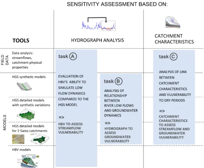
Figure 1.1: Structure of the “Low flow” project (Arbeitsgruppe Low flow (2018)): main tasks (light blue), carried out with various tools (left column) necessary to develop the sensitivity assessment methods (two main columns). Many interactions between the different tasks took place. This thesis focuses on the sensitivity assessment based on catchment characteristics with the use of synthetic models and data analysis (“task C” and two top tools).
The structure of the “Low flow project” is illustrated in Figure 1.1. The sensitivity of a catchment to dry periods can be assessed based on discharge data (observed or simulated, “Hydrograph analysis” column) or based on the physical characteristics of the catchment when no discharge data is available (“Catchment characteristics” column). The mains tasks of the project are defined for each of these assessment methods. To carry out these tasks, different tools such as models and field data analysis are used and listed on the left side of the figure. This thesis focuses mainly on the sensitivity assessment based on catchment characteristics with the use of synthetic models and data analysis (“task C” and two top tools). The relationship between low flows and groundwater dynamics is also characterised by this work (“task B”). The present study thus develops the underlying scientific principles – the characterisation of streamflow and groundwater dynamics under dry conditions – necessary to elaborate the guideline for the assessment of water resource sensitivity.
The methodology of the thesis is described more thoroughly after the description of the main physical processes relevant to the present work and a brief literature review.
1.2
Physical processes
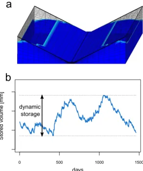
Figure 1.2 gives a schematic overview of the hydrological cycle in a catchment and il-lustrates the important surface and groundwater fluxes (in blue). Storage and discharge processes taking place in the catchment, i.e. the catchment response to the meteorological input, are governed by its physiographic properties (Smakhtnin (2001)). Soil and land use properties, topography and subsurface characteristics determine overland and channel flow, infiltration, groundwater recharge, flow and discharge to the stream. The outflow of the catchment thus reflects the combination of multiple processes.
In the absence of precipitation, surface hydrological processes and their related proper-ties become less relevant and streams are mainly fed by groundwater (Smakhtnin (2001), Peters et al. (2003), Peters et al. (2005), Matonse and Kroll (2013)). The contribution of aquifers to the stream depends on previous meteorological conditions, on their hydrogeo-logical properties and topographical settings as well as on their connection to the stream. Catchment dynamics under dry conditions therefore also depends on storage processes dur-ing precipitation events.
Figure 1.2: Schematic representation of the hydrological cycle (after Freeze and Cherry 1979). Fluxes are indicated in dark blue.
Understanding the physical processes determining the dynamics of rivers and aquifers is thus crucial to assess the water resources sensitivity to dry spells. These mechanisms remain, however, still poorly characterised (Van Loon (2015)). To cope with these
limit-thus groundwater contribution to streamflow should especially be considered, such as the geological settings, hydrogeological properties and topography. Based on these considera-tions, the scope of the thesis can be refined as follows:
The catchment controls on streamflow dynamics are investigated, with the emphasis put on the low-flow range and on the role of hydrogeological and topographical characteristics. This exploration should allow distinguishing the physiographic properties that substantially influence the catchment behaviour under dry conditions, hence providing tools for the identification of regions sensitive to dry spells.
A short literature review is now proposed, followed by the methodology of the thesis. In the introductions of Chapters 2 and 3, a more exhaustive description of previous findings is made.
1.3
Literature review
Research carried out in both the fields of hydrology and hydrogeology is relevant for the present work. Previous findings on the relationship between physical catchment proper-ties and streamflow dynamics with a focus on low flows are first summarised, followed by groundwater studies dedicated to topographical and hydrogeological controls on ground-water flow.
1.3.1
Studies relating stream dynamics and catchment properties
Assessing the relationship between physiographic characteristics and stream dynamics is crucial for understanding hydrological processes, for determining the behaviour of un-gauged catchments and for the prediction of streamflow under changing climatic, land use or water use conditions. Numerous studies have thus been dedicated to assess the impact of vegetation, soil, topography and geology on the catchment response to the meteorological signal. As illustrated by Hrachowitz et al. (2013) or Bl¨oschl et al. (2013) in their reviews, a whole panel of articles investigates the role of catchment properties in governing streamflow dynamics for the purpose of hydrological prediction in ungauged basins. Various studies aim for instance at expressing the flow duration curve based on meteorological and geo-morphological characteristics (e.g. M¨uller et al. (2014), Pugliese et al. (2014), Castellarin et al. (2004), Castellarin et al. (2007), Botter et al. (2007a), Botter et al. (2007b), Doulat-yari et al. (2015), Cheng et al. (2012), Coopersmith et al. (2012), Ye et al. (2012)). As reviewed by Razavi and Coulibaly (2013), most of the studies in the field of streamflow fo-cus on identifying the best methods to transfer model parameters from one catchment to the other, typically using hydrological models such as HBV (Seibert and Vis (2012)).
Numer-ous studies also aim at better characterising the effect of catchment properties on low-flow behaviour (see e.g. reviews by Van Loon (2015), Price (2011), Smakhtnin (2001)).
From this profusion of articles that investigate catchment controls on streamflow dy-namics, relatively few consider actual geological or hydrogeological characteristics. Razavi and Coulibaly (2013) illustrate this in their review on regionalisation methods: catchment area, elevation, and slope are the most widely used properties considered by researchers. Another similar review suggests that drainage area, land use, slope, soil classification and elevation are the most recurrent physiographic characteristics in such studies (He et al. (2011)).
Nonetheless, various studies have shown that specific geological units or hydrogeolo-gical characteristics substantially influence streamflow dynamics. A few studies carried out in California and Oregon highlighted the importance of geology in determining the stream-flow regime and its response to climate change (Tague and Grant (2004), Mayer and Naman (2011), Jefferson et al. (2008)). The role of sandstone in stabilising streamflow has been identified by different case studies (e.g. Jencso and McGlynn (2011), Nippgen et al. (2011), Naef et al. (2015)). Various articles indicate that the bedrock can substantially contribute to baseflow (Bloomfield et al. (2009), Uchida et al. (2008), Andermann et al. (2012), Birkel et al. (2014), Welch and Allen (2012)). The importance of quaternary formations such as alluvial deposits for streamflow generation has been less characterised, although research in Switzerland suggest that these local geological units can impact low-flow dynamics (K¨aser and Hunkeler (2016), Naef et al. (2015)).
Despite the numerous studies dedicated to the subject, the understanding of catchment controls on streamflow dynamics, and especially on low flows, is still limited. We identify two main reasons to explain this:
• The physiographic influences on streamflow are manifold, can be combined and are site-specific. It is thus highly complex, based on observed data, to disentangle the ef-fect on hydrological signatures of each characteristic in a systematic and independent manner.
• Although subsurface processes can play a predominant role in the hydrological cycle (Freeze and Cherry (1979)), especially under dry conditions, geological and hydro-geological descriptors are only rarely considered in these studies. Catchment controls on streamflow dynamics are generally assessed with a “surface perspective” and con-sequently a simplistic conceptualisation of groundwater processes.
Whereas the first limitation is inherent to the complexity of physical processes occurring in nature, the rare consideration of (hydro)geological descriptors in hydrological studies is mainly attributable to the choice of considered parameters. Of course, the characterisation of the subsurface is difficult, and detailed hydrogeological characteristics are thus often
rare inclusion of geology in such studies. The fundamental reason for this poor considera-tion of geology may be more likely bound to the conceptualisaconsidera-tion of storage processes in catchment hydrology. Streamflow variations are commonly associated to the storage beha-viour of the catchment in the field of hydrology (Kirchner (2009)), the importance of the subsurface domain being in a sense acknowledged. In fact, groundwater theory has consid-erably contributed to the conception of catchment dynamics and to hydrological modelling, as illustrated by multiple approaches derived from the Boussinesq equation for sloping aquifer (Troch et al. (2013)). However, storage in hydrology is traditionnally represented by a single or a few lumped reservoirs and this conceptualisation is widely used in hydro-logical models such as HBV. The parameters related to these storage units, either modeled or extracted by hydrograph analysis, are then commonly interpreted as the reflection of catchment-scale hydraulic properties (Kirchner (2009)). Various studies, for instance, use streamflow-based indicators such as the baseflow index (e.g. Cheng et al. (2012)) or model parameters (e.g. De Felice et al. (1993), Castellarin et al. (2004), Castellarin et al. (2007)) as descriptors of the contribution of groundwater. This simplistic conceptual structure po-tentially hinders the consideration of the actual complexity of subsurface processes, and thus the general understanding of hydrological processes.
1.3.2
Studies relating groundwater dynamics and catchment
proper-ties
Although research in the field of groundwater presented here do not implicitly deal with streamflow dynamics, their findings can be relevant for surface hydrology because subsur-face flow contributes to streamflow and especially low flows.
The influence of topography, recharge and permeability on groundwater flow in the bedrock has been investigated by various hydrogeological studies using physically-based models. Gleeson and Manning (2008) have shown that the water table elevation depends on the ratio of the hydraulic conductivity to recharge rates. Haitjema and Mitchell-Bruker (2005) propose a criterion to determine whether the water table is topography- or recharge-controlled. The developed combination based on the Dupuit-Forchheimer approximation is composed of the ratio between recharge and hydraulic conductivity, as well as geometrical aquifer properties and topographical characteristics. In regions with high precipitation rate or limited permeability, the water table is often topography-controlled and it evolves parallel and close to the surface. In arid regions, during dry periods or when hydraulic conductivity values are high, the water table is lower and thus less influenced by topography and gov-erned by recharge instead. Other studies have explored the impact of topography, recharge and/or bedrock permeability on groundwater fluxes and flow patterns using synthetic catch-ments developed with groundwater distributed models (e.g. Gleeson and Manning (2008), Welch et al. (2012), Welch and Allen (2012), Welch and Allen (2014)). The findings of
these studies suggest that topographical and hydrogeological features, as well as recharge rates, influence groundwater processes in a combined way.
With regards to the objectives of the thesis, following gaps can be identified in the mentioned groundwater research:
• The consequences of the results for streamflow dynamics are not discussed, as it is not the scope of these studies.
• The studies mainly focus on groundwater processes in the bedrock, whereas the con-tribution of more local alluvial aquifers might be relevant for streamflow dynamics. • They do not assess systematically the combined influence of topographical and
hy-drogeological properties on groundwater flow under transient recharge conditions.
1.4
Methodology and structure of the thesis
To tackle the limitations mentioned previously, this thesis is based on two main research lines that explore the relationships between catchment properties and dynamics using hydrogeological models (Chapter 2) and observed data (Chapter 3).
Classical hydrological models are of great utility to assess river dynamics of large-scale catchments and efficiently simulate floods. However, their reproduction of low-flow dy-namics is poor (Staudinger et al. (2011)). These models, as they represent hydrological and groundwater processes in a simplistic way, neglect the complexity related to the the main contribution to streamflow in the absence of rain. Besides, the structure and the parametrisa-tion of this type of models can significantly influence the simulated low flows (Vansteen-kiste et al. (2014)). Numerical, physically-based models allow coupling groundwater and river dynamics and are thus more appropriate for low-flow simulations (Dassargues et al. (1999)). Because of their complex parametrisation and the important computational re-quirements, their application to large and numerous catchments in the perspective of identi-fying regions vulnerable to droughts is nonetheless not conceivable yet.
In the first approach, simple but numerous numerical models are thus developed, which take advantage of the physically-based reproduction of surface and subsurface processes offered by such models. The influences of topographical and hydrogeological features on low flows and groundwater dynamics are systematically assessed with these synthetic mod-els. As the catchment configurations are defined in the experimental design, the physical characteristics are known. It is thus possible to test the impact of hard to obtain or highly uncertain properties such as the permeability of the bedrock. The topographical and hydro-geological features can be varied independently and their impact on flow dynamics can be identified and quantified systematically. This method thus allows disentangling artificially
The HydroGeoSphere software (HGS, Aquanty (2015)) is used, which simulates surface and subsurface hydrological processes in a fully coupled, physically based way. Owing to this integrated consideration of streamflow and groundwater, the relationship between low flow and storage dynamics can consequently be analysed in detail. All processes relevant for the water cycle, from precipitation to the stream discharge, can be simulated by the HGS model. This software thus allows, for instance, a full consideration of topography, land use and vegetation properties, soil layers, geological formations and their inherent hydrogeological properties, as well as precipitation input. A control-volume finite element approach is used to solve groundwater and surface water flow equations sim-ultaneously. The diffusion wave approximation to the Saint-Venant equations are used to solve the 3D variably saturated subsurface flow. The 2D surface flow is solved by Richards equation. Water can move freely from one domain to the other according to a first-order leakage coefficient based on head differences that couples the two compartments. Thanks to this integrated consideration of surface and subsurface processes, the river location does not have to be defined and “naturally” forms according to the meteorological conditions. This point is essential for the assessment of low-flow dynamics and consequently for the present work. Further details on HGS are provided for instance by Brunner and Simmons (2012).
In the second approach (Chapter 3), the relationships between catchment properties and streamflow dynamics are explored with observed data using linear regression analysis. This study mainly distinguishes itself from aforementioned similar research by its more explicit consideration of geology and hydrogeology. The investigation focuses on 22 catchments of the Swiss Plateau and Prealpes, located in the Molasse basin. The properties of these catchments are also used as a basis for the physical properties values of the synthetic ap-proach. This region is of particular interest for water resources management, as it is densely populated. Besides, it provides a rich hydrogeological variety: the sedimentary rocks of the Molasse are characterised by very diverse lithologies such as clayey deposits, sandstones and conglomerates. These different bedrock formations are often combined to alluvial qua-ternary deposits of large extent and permeability.
In this approach, both the bedrock and the alluvial quaternary deposits are thus char-acterised in detail. Various other catchment descriptors related to land use, soil and to-pography are included in the analysis, along with precipitation characteristics. The entire range of streamflow dynamics is considered and quantified using numerous discharge in-dices. This observation-based study offers the possibility to validate and widen the findings of the synthetic approach. Whereas only a limited number of catchment properties are varied in the first investigation and processes remain synthetic, the assessment of exist-ing catchments allows upgradexist-ing the results to a higher complexity level of physiographic combinations and catchment configuration.
In Chapter 4, the results of the two approaches developed in Chapters 2 and 3 are com-pared and the complementarity of the approaches is discussed. Based on their findings, a guideline for the assessment of sensitivity of water resources to dry periods is proposed. In Chapter 5, the general conclusions of the PhD thesis and their implications for further research, data acquisition and monitoring are discussed.
Exploring geological and topographical
controls on low flows with
hydrogeological models
This chapter has been submitted to Groundwater as an original research article.
Authors: C. Carlier, S.B. Wirth, F. Cochand, D. Hunkeler, P. Brunner (University of Neuchˆatel)
Keywords: low flow, groundwater, numerical modelling, catchment hydrology, geology, topography
Key points:
• Hydrogeological and topographical controls on low flows are assessed using numer-ical models with systematnumer-ically varied physnumer-ical properties
• The permeability of the bedrock exerts a dominant control on groundwater storage dynamics and on low flows
• We characterise the combined influence of slopes and bedrock permeability on low flows and the relative contribution of the alluvial aquifer
Abstract
This study investigates how catchment properties influence low-flow dynamics. With 496 synthetic models composed of two geological units (bedrock and alluvial aquifer), we sys-tematically assess the impact of the hydraulic conductivity of both lithologies, of the hill-slope and of the river hill-slope on catchment dynamics. The physically-based hydrogeological simulator HydroGeoSphere is employed, which allows obtaining the following streamflow and groundwater indicators: Q95/Q50 (discharge exceeded 95% of the time divided by median discharge), Q95 and dynamic groundwater storage. Q95 is highly correlated to dy-namic groundwater storage (R2=96%). The hydraulic conductivity of the bedrock Kbedrock is the only catchment property exerting an overall control on low flows and explains 60% of the variance of Q95/Q50. The difference in dynamics of catchments with same Kbedrock depends on hillslope gradients and the alluvial aquifer properties. The buffering capacity of the bedrock is mainly related to Kbedrockand the hillslope gradient. We thus propose the dimensionless bedrock productivity index BPI that combines these characteristics with the mean net precipitation. For catchments with no alluvial aquifer, the BPI explains 82% of the variance of the ratio of Q95 to mean net precipitation. The alluvial aquifer can significantly influence low flows when the bedrock productivity is limited. Besides, it can enhance dy-namic storage in the surrounding bedrock and produce an additional stable contribution to streamflow. The study provides quantitative insight into the complex interrelations between geology, topography and low-flow dynamics and challenges previous studies which neglect or oversimplify geological characteristics in the assessment of low flows.
2.1
Introduction
In the context of climate change, it is essential to identify regions vulnerable to dry spells. The probability of water scarcity to occur depends on meteorological factors and the abil-ity of the catchment to store and release water in the absence of precipitation. Catchment storage and discharge processes are governed by physiographic characteristics (Smakhtnin (2001)). The diversity of geology, topography, soil and land use is largely superior to pre-cipitation discrepancies at typical water management scales (Van Loon and Laaha (2015)). Identifying key catchment properties controlling streamflow and groundwater dynamics during dry seasons is thus a precondition for assessing the vulnerability of water resources. The discharge at the outlet often reflects the combined surface and subsurface dynamics and is thus of great utility to assess the low-flow behavior of a catchment.
Numerous hydrological studies were dedicated to better characterise the mechanisms governing low flows and the relationship between low-flow dynamics and catchment prop-erties (see, e.g. reviews by Price (2011), Smakhtnin (2001) and Van Loon (2015)). It is widely recognized that low flows mainly derive from groundwater (Smakhtnin (2001), Peters et al. (2003), Peters et al. (2005), Matonse and Kroll (2013), Dassargues et al. (1999)). A few case studies have established a link between geology and low-flows. Tague and Grant (2004) identifiy, for instance, the dominant control of a young volcanic geolo-gical unit on the flow regime of the studied region in Oregon, this geologeolo-gical formation having an exceptionally high permeability. Pfister et al. (2017) shows that bedrock per-meability significantly influences the ratio between average summer and winter run-off of 16 investigated catchments in Luxembourg. For a selection of Swiss catchments, Naef et al. (2015) associates higher low flows with slowly draining porous bedrock and low streamflow during dry periods for catchments dominated by Moraine deposits.
However, broader low-flow studies rarely include detailed geological or hydrogeolo-gical descriptors. If the subsurface is considered, it often refers to shallow characteristics such as soil parameters (e.g., Kroll et al. (2004)), to wide classes such as fractured, por-ous and karstic aquifers (Stoelzle et al. (2015)) or it is defined using indices derived from streamflow such as the baseflow index (Institute of Hydrology (1980)) and recession para-meters (e.g., Kroll et al. (2004), Van Loon and Laaha (2015)). In hydrological models, the conceptualization of groundwater systems is often represented by a lumped reservoir (Matonse and Kroll (2013), Broda et al. (2012)). In a catchment, groundwater storage can, however, occur in different geological units of distinct hydrogeological properties, leading to strongly differing storage dynamics. These complex storage mechanisms are rarely ad-dressed in hydrological studies, as groundwater storage is typically represented by a simple or a series of reservoirs. While these approaches theoretically represent different storage units, they are not intended to and cannot represent the feedback mechanisms between the reservoirs.
Another example is the widespread application of the Boussinesq equation for sloping aquifers, or of other approaches derived from it, used to relate catchment scale aquifer properties to baseflow (Troch et al. (2013)). As a result, the understanding of catchment controls on low flows and on storage and release processes is still to be improved and remains an active research field (Van Loon (2015), Price (2011)). This is illustrated by the often limited ability of classical hydrological models to reproduce low flows (Staudinger et al. (2011)).
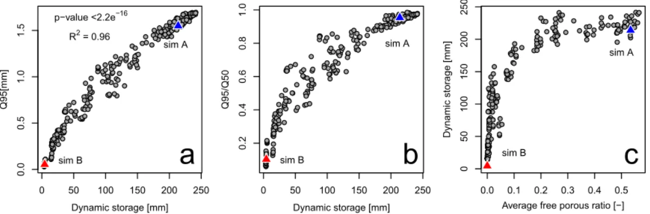
A better understanding of low-flow dynamics thus implies a more detailed considera-tion of storage variaconsidera-tions in distinct geological units. Due to the heterogeneity of subsur-face properties, groundwater level data are often only representative of the local settings. Consequently, catchment storage is not directly measurable and its estimation is problem-atic (Kirchner (2009), Birkel et al. (2014), Mcnamara et al. (2011)). Dynamic storage is commonly defined as the storage that governs streamflow dynamics (Buttle (2016), Spence (2007)), and is generally inferred from river hydrographs. Estimates of dynamic storage can vary significantly depending on the calculation method (Staudinger et al. (2017)).
Various groundwater studies analyzed the influence of topography, recharge and per-meability on groundwater flow in the bedrock. According to the hydrologically active bedrock hypothesis (Uchida et al. (2008)) the bedrock is an active reservoir that signi-ficantly contributes to baseflow (Andermann et al. (2012), Birkel et al. (2014), Welch and Allen (2012), Tague and Grant (2004)). The hydraulic conductivity of the bedrock con-trols storage processes (Hale et al. (2016), Pfister et al. (2017)). Most importantly, the ratio of the hydraulic conductivity to recharge rates has been shown to be relevant for wa-ter table elevation (Gleeson and Manning (2008)). Haitjema and Mitchell-Bruker (2005) propose a criterion based on the Dupuit-Forchheimer approximation combining this ratio with geometrical aquifer properties and topographical characteristics to determine whether the water table is controlled by the topography or the recharge. Various studies have used spatially distributed synthetic groundwater models to identify and explore how topography, recharge and/or bedrock permeability influence groundwater fluxes and flow patterns (e.g., Gleeson and Manning (2008), Welch and Allen (2012), Welch et al. (2012), Welch and Al-len (2014)). These studies highlight the complex interplay of topography and hydrogeology on groundwater flow. They however mainly focus on the geology of the bedrock.
In a study case, K¨aser and Hunkeler (2016) have shown that alluvial aquifers, even if they represent only a small portion of the catchment surface, can contribute significantly to the catchment outflow especially during low-flow periods. Alluvial aquifers can thus also be relevant for total catchment groundwater storage. Moreover, alluvial valley aquifers are of great importance for water supply purposes. The impact of the hydrogeological characteristics of both the bedrock and the alluvial aquifer on low flows, combined to different topography, has not been explored explicitly so far.
The aim of this study is to improve the process understanding of low-flow dynamics by explicitly taking into account groundwater storage processes and by focusing on catchment properties that govern groundwater flow. We assess the combined impact of topography as well as of the hydrogeological properties of the bedrock and alluvial aquifers on low flows and groundwater storage processes in a systematic way. We use an integrated mod-elling approach coupling surface and groundwater processes. Open-book-like or so-called V-catchment models composed of homogeneous bedrock and a more permeable alluvial aquifer are developed with the HydroGeoSphere software (Aquanty (2015)) to test the hy-dro(geo)logical response to transient precipitation. River slope, hillslope and hydraulic conductivity of bedrock and alluvial aquifers are varied systematically, and width-to-length ratios and bedrock porosity are tested with a limited number of catchments, leading to a total of 496 models. While the influence of these characteristics has been explored individually in other studies, the combined controlling mechanisms of these features on low-flow dynam-ics are assessed here. Furthermore, the characterisation of feedback mechanisms between low flows and groundwater dynamics is made possible with the physically based models. Based on the improved process understanding, key catchment properties that govern low flow dynamics and the relative importance of bedrock and alluvial aquifers are identified.
2.2
Methods
2.2.1
Numerical model and data analysis
The HydroGeoSphere (HGS) software is used, as it simultaneously simulates surface and subsurface flow in a physically based, distributed manner. 3D variably saturated subsurface flow and 2D surface flow are solved by Richards equation respectively with the diffusion wave approximation to the Saint-Venant equations. The two domains are coupled through a first-order leakage coefficient based on head differences, allowing water to move from one domain to the other in a physically based way. Groundwater and surface water flow equations are solved simultaneously using a control-volume finite element approach. An adaptive time stepping approach is employed and time steps are homogenized to daily val-ues in the post-processing step. Further details on HGS can be found in Aquanty (2015) or Brunner and Simmons (2012). The numerous HGS outputs, such as discharge time series and storage variations in the different aquifers, are managed and analyzed using the R code (R Core Team (2017)) and Tecplot (Tecplot Inc. (2013)), a software environment developed to post-process simulations of fluid dynamics.
2.2.2
Catchment configuration
As topographical and hydrogeological characteristics influence catchment dynamics in a complex, interrelated way, the catchment configurations should cover a wide range of
pos-sible combinations of these parameters. The synthetic models should also be simple enough to be representative of a broad spectrum of catchments and yet include the complexity of physical processes that occur in reality. We choose an “open-book” or tilted-V geometry as it represents the simplest hydrographic landscape unit. Besides, this set-up permits a straightforward parametrization of topography and is an ideal framework to generate a wide range of hydrograph dynamics. This geometry results in the occurrence of various hy-drological processes: saturated and unsaturated groundwater flow, infiltration/exfiltration, overland flow and streamflow (Partington et al. (2012)).
The standard catchment set-up is shown in Figure 2.1. The models have a surface area of 12 km2 with a length (y-axis) to width (x-axis) ratio of 3:1, a valley width of 100 m and a 1 m deep and 8 m wide river bed. These scales are typical for catchments of this size located in the Swiss Plateau and the Prealpes. The surface outlet is located 30 m higher than the base of the model at this x-y location. The synthetic catchments are characterised by two slope gradients: the hillslope that corresponds to the slope lateral to the stream (x-axis), and the river slope that defines both the longitudinal valley slope and the slope of the catchment base. The models are composed of two hydrogeological units: bedrock and alluvial deposits. The alluvial unit has a constant thickness of 10 m and extends over the whole width of the valley bottom (100 m). Its permeability is either higher or equal to the bedrock permeability, the latter case representing a catchment with no alluvial deposits.
Bedrock
Alluvi
al unit
hillslope river slope 12 km2 x y z 2000m 6000m 8m 10m 100m 1m 30mFigure 2.1: Standard setup of the synthetic models. The hydraulic conductivity of the bedrock and of the alluvial aquifers, the river slope and the hillslope are varied systematically.
2.2.3
Experimental design
The study is based on a central model batch (group 1) to systematically test the influence of hydraulic conductivity and slope gradients. A limited number of additional models (group 2) are developed to test the impact of single modifications of bedrock porosity, width-to-length ratio (aspect ratio) and meteorological forcing.
Catchment group 1: systematic parameter variations
We vary four catchment parameters: the hydraulic conductivities of bedrock and alluvial deposits, as well as the hillslope gradient and the river gradient (see Figure 2.1). To each of the four parameters, four discrete values are assigned and all possible combinations of parameter values are simulated. Hence 256 (44) catchments with different parameter com-binations are generated and run. Table 2.1 indicates the four values assigned to each tested catchment property. The bedrock hydraulic conductivities chosen for this study cover a wide range of values observable in reality: from a low permeability of 10-8m/s correspond-ing to an aquitard of relatively high permeability of 10-5 m/s corresponding to a porous aquifer (e.g. sandstone). The hydraulic conductivity of the alluvial deposits varies between bedrock permeability (no distinct hydrogeological valley unit) to a high permeability of 10-2 m/s typical for gravels. Three values were defined for hillslope and river slope (Table 2.1), corresponding to low, medium and high values typically observable in catchments of mod-erate elevation of Switzerland. A fourth value is added (35% for hillslope and 9% for river slope) to complete the parametrization.
Table 2.1: Values of catchment properties
Parameters: Values
Hydraulic conductivity of bedrock: 10−8m/s 10−7m/s 10−6m/s 10−5m/s
Hydraulic conductivity of alluvial deposits: none 10−4m/s 10−3m/s 10−2m/s
Hillslope: 5% 18% 35% 50%
River slope: 0.50% 3% 9% 15%
Figure 2.2 shows four examples of catchment configurations: hillslope HS is set to the lowest value 5% (a and c) and highest value 50% (b and d), combined to a low river slope RS of 0.5% (c and d) and high river slope of 15% (a and b). The parameter hillslope delineates topography in two ways: by defining the lateral surface gradient converging to the valley bottom as well as by determining the volume available to store water. The river slope sets the slope of the inclination plane forming the base of the catchment, but does not impact available storage volume. These differences will be considered in the result analysis and discussed.
X 1000 1500 2000 0 500 0 100 Y 0 2000 4000 6000 X 0 500 1000 1500 2000 Y 0 2000 4000 6000 0 500 1000 RS = 0.5%, HS = 50% X 0 500 1000 1500 2000 Y 0 2000 4000 6000 0 500 1000 RS = 15%, HS = 50% X 1000 1500 2000 Y 0 2000 4000 6000 RS = 0.5%, HS = 5% RS = 15%, HS = 5% 0 500 1000 500 1000 500 0 Z Z Z Z
a
c
b
d
Figure 2.2: Examples of different topographical configurations (RS = river slope, HS = hillslope). A change in hillslope implies a change in catchment volume, whereas it is not the case for river slope variations.
Catchment group 2: assessment of importance of porosity, aspect-ratio and meteoro-logical forcing
The supplementary catchments are only composed of bedrock (no alluvial aquifer) and all have a river slope of 3%. 20 new combinations of hillslope-hydraulic conductivity of bedrock are modeled to sample the parameter space more densely (permeability of 4e-7, 7e-7, 4e-6, 7e-6 and 10-4m/s combined to the 4 standard hillslope values). Along with all combinations of hillslope-hydraulic conductivity of “group 1” except those composed of the lowest hydraulic conductivity (10-8 m/s), these additional combinations result in 32 hillslope-hydraulic conductivity couples, which are used as a basis to test the following elements:
• Role of bedrock porosity: bedrock porosities of 0.05 and 0.2 are tested with 16 hillslope-permeability combinations (32 models). The high upper value is deliber-ately chosen to explore endmembers of the parameter distribution.
• Role of aspect ratio: widths to lengths in meters of 1000:12’000, 3000:3000 and 6000:2000 are tested with all hillslope-permeability combinations (96 models) • Variation in meteorological input: three other net precipitation time series measured
during the same period in other geographic extremes of Switzerland (Cimetta, St. Gallen, Aigle, MeteoSwiss) are applied to the 32 models group (96 models).
2.2.4
Mesh and simulation specifications
The 2D-mesh structure is composed of 1560 rectangles (1647 nodes) reproduced in the 28 vertical layers, the 3D structure including 43’680 elements (47’763 nodes). The elements have a constant y-axis discretization of 100 m, whereas the discretization in the x-direction varies between 100 m and 2 m from the hillslope top to the riverbed. The top 10 m of the model is composed of 18 layers of increasing thicknesses with depth ranging from 6 cm to 1 m. The thickness of these top layers is constant over the entire model extent. The discretization of the ten lower layers is proportional to the depth of the catchment: it is fixed in the valley, varying from 1 m to 4 m with depth, and decreases laterally depending on the hillslope gradient.
A no-flux boundary is assigned to the bottom of the model and all lateral faces. A critical-depth boundary is applied to the whole surface perimeter of the catchment and groundwater consequently exits by the surface domain. Due to the slope configuration, catchment discharge only occurs at the lowest point, i.e., at the outlet, of the catchment and water flow is concentrated in the valley bottom. The simulated discharge considered in this study thus represents the entire catchment dynamics, integrating both groundwater and streamflow.
All the models are first run with a constant rainfall applied to each surface element for 10’000 days to ensure steady state (net rainfall equals discharge with 0.1% margin). Start-ing from the obtained steady state, models are then run over a period of 4 years with daily rainfall obtained from a measuring station (Huttwil, Switzerland, national meteorological service of Switzerland MeteoSwiss) between the 01.01.2000 and the 31.12.2003, 2003 be-ing an especially dry year in Switzerland. The results of this study are focused on this four years transient simulation period. We chose not to explicitly simulate evapotranspiration with HGS and simply corrected the rainfall signal for evapotranspiration by dividing it by two, which corresponds to the water balance of the Huttwil region. As this study focuses on comparing the response of catchments with respect to their different physical properties, the input itself, being the same for all model realizations, is of lesser concern as long as it produces a wide spectrum of catchment hydrographs.
Even though groundwater can partially flow in fractures in the bedrock, this dual poros-ity is of less relevance for catchment-scale processes. The numerical models are thus defined as porous equivalent matrices. Except for the variations of hydraulic conductiv-ity and porosconductiv-ity mentioned previously, the same values for subsurface parameters are used for bedrock and alluvial deposits in order to essentially capture the influence of these varied characteristics on model outputs. The Van Genuchten parameters are defined to represent sand- to sandstone-like flow unsaturated dynamics adequate for both hydrogeological units: values of 8 m-1 resp. 2 [-] are used for alpha resp. beta. The sensitivity of catchment dy-namics to these parameters was tested for a selection of models and showed that they can slightly impact the saturation distribution in the unsaturated zone but not significantly the storage and streamflow dynamics. Therefore, they are kept constant. For the remaining