HAL Id: hal-02012174
https://hal.archives-ouvertes.fr/hal-02012174
Submitted on 14 Oct 2020
HAL is a multi-disciplinary open access archive for the deposit and dissemination of sci-entific research documents, whether they are pub-lished or not. The documents may come from teaching and research institutions in France or abroad, or from public or private research centers.
L’archive ouverte pluridisciplinaire HAL, est destinée au dépôt et à la diffusion de documents scientifiques de niveau recherche, publiés ou non, émanant des établissements d’enseignement et de recherche français ou étrangers, des laboratoires publics ou privés.
Holocene deposits in the lower section of the Assaka
wadi, South Morocco : Preliminary results.
Julien Mathieu, André Weisrock, Luc Wengler, Jacques Elie Brochier, G
Even, Michel Fontugne, Norbert Mercier, Abderrahman Ouammou, F
Senegas, Hélène Valladas, et al.
To cite this version:
Julien Mathieu, André Weisrock, Luc Wengler, Jacques Elie Brochier, G Even, et al.. Holocene deposits in the lower section of the Assaka wadi, South Morocco : Preliminary results.. Quaternaire, AFEQ-CNF INQUA, 2004, 15 (1-2), pp.207-218. �10.3406/quate.2004.1768�. �hal-02012174�
Quaternaire, 15, (1-2), 2004, p 207-218
HOLOCENE DEPOSITS IN THE LOWER SECTION OF THE ASSAKA WADI, SOUTH MOROCCO: PRELIMINARY RESULTS
Julien MATHIEU1, André WEISROCK1, Luc WENGLER2, Jacques-Élie BROCHIER3, Georges EVEN4, Michel FONTUGNE5, Norbert MERCIER5, Abderrahman OUAMMOU6, Franck SÉNÉGAS7, Hélène VALLADAS5, Jean-Louis VERNET8 and Laurent WAHL1
ABSTRACT
At the southern side of the Anti- Atlas mountains, the lower section of the Assaka wadi valley joins the Atlantic ocean by crossing an Appalachian basin and range area Holocene deposits of the lower section of the Assaka wadi show two main sedimentary formations the upper sheet-fans and the lower terraces The upper sheet-fans are probably from the lower Rharbian (Holocene) age, they are located above the Soltanian (Wurmian) formations at the outlets of tributaries They consist of accumulations with silts, aeolian quartz and high palygorskite contents After this penod, a trench cut through the older formations took place between 8 000 years BP and 4 200 years BP The lower over terraces, 5 to 1 1 metres thick, are inset in the trench cut through the Soltanian formations and show four superimposed and fining upwards (from pebble to silt) cross-bedded units This study shows many geodynamic and palaeoclimatic conditions Lower Rharbian fans indicate that the climate was sufficiently and to denude the slopes, where, during big storms, gullies and run-off supplied the Assaka wadi with silts and sands. Torrential floods cut the Soltanian formations and then created the Middle Rharbian low terrace Finally, the Historic terrace, superimposed onto the Middle Rharbian one, shows that important flood events took place during the XVII0 and XVIII° centuries, but nevertheless with low frequency However, this sequence indicates wetter conditions during an and episode The 14C age is contemporary with the "cold winters" in Western Europe ; this fact proves that the synoptic conditions in South Morocco were the same at 280±30 years B P as at present.
Key-words: And zone, Morocco, Holocene, alluvial terraces, fluvial geodynamic, stratigraphy, palaeochmatology RÉSUMÉ
LES DÉPÔTS HOLOCÈNES DE LA BASSE VALLÉE DE L'OUED ASSAKA, SUD-MAROC • RÉSULTATS PRÉLIMINAIRES
L'oued Assaka, exutoire d'un vaste bassin versant (7 000 km2) rejoint l'océan Atlantique sur le versant sud de l' Anti-Atlas en recoupant une zone de relief appalachien Des cônes attnbuables au Pleistocene supéneur ou au Rharbien ancien (Holocène ancien) surmontent les formations alluviales et colluviales soltaniennes (Wurm), avant que celles-ci soient entaillées sur 20 à 25 mètres , ils sont circonscnts aux débouches des foums que déterminent les affluents de l'oued Assaka Ils sont constitués de limons sableux nches en grains de quartz éohsés et par des teneurs en palygorskite qui s'accentuent de la base vers le sommet. Aux environs de 8 000 BP, une phase d'incision linéaire importante entailla les dépôts plus anciens sur une épaisseur de 20 mètres De basses terrasses sont emboîtées dans les dépôts soltamens D'une épaisseur vanant de 5 à 1 1 mètres, elles sont constituées de séquences granoclassées qui mettent en évidence des géodynamiques et des ambiances climatiques contrastées Le Rharbien ancien reflète une sécheresse suffi sante pour dénuder en partie les versants, qui lors d'orages probablement assez localisés, alimentent les affluents de l'oued principal en limons sableux. Les crues torrentielles (chaînant des blocs surdimensionnés) ont incisé les formations soltaniennes -essentiellement limoneuses- et ont mis en place les basses terrasses du Rharbien moyen Enfin, la terrasse histonque étagée sur celle du Rharbien moyen montre la permanence de crues importantes durant les XVIIème et XVIIIème siècles avec une fréquence cependant moins élevée En outre, cette séquence indique l'existence de conditions humides durant un épisode ande sous cette latitude contemporaines des "hivers froids" de l'Europe de l'Ouest ; ce qui prouve que les situations synoptiques dans le
Sud du Maroc étaient les mêmes à 280±30 ans BP qu'aujourd'hui.
Mots-clés : Régions andes, Maroc, Holocène, terrasses alluviales, géodynamique fluviale, stratigraphie, paléochmatologie. ' Université de Nancy 2, Département de Géographie, 23, Bd Albert 1er, BP 33-97, 54015 NANCY cedex
2 Université de Perpignan et UMR 5590, Laboratoire de Préhistoire, Université de Perpignan, 52, avenue de Villeneuve, 66860 PERPIGNAN cedex 3 Laboratoire de Paléontologie humaine et de Préhistoire, UMR 6569 du CNRS, Université de Provence, centre Saint-Charles, Place Victor Hugo, Case 54, 13331 MARSEILLE Cedex 3
4 Université Henri Poincaré, 54000 NANCY
5 Unité mixte de recherche CEA-CNRS, Laboratoire des Sciences du Climat et de l'Environnement, Domaine du CNRS, Bât 12, 91198 GIF-SUR- YVETTE cedex
6 Université Ibn Zohr, Faculté des Lettres et Sciences humaines, Département de Géographie, Cite Dakhla, AGADIR
7 UMR 5554, Laboratoire de Paléontologie et EPHE, ISEM, Université de Montpellier II, place E Bataillon, 34095 MONTPELLIER cedex 5 8 Laboratoire de Paléobotanique, Environnement et Archéologie, Université de Montpellier II, Place E Bataillon, 34095 MONTPELLIER cedex 5
Manuscrit reçu le 06/02/2003, accepté le 19/01/2004 Quaternaire, 15, (1-2),2004, p. 207-218.
HOLOCENE DEPOSITS IN THE LOWER SECTION
OF THE ASSAKA WADI, SOUTH MOROCCO:
PRELIMINARY RESULTS
•
Julien MATHIEU', André WEISROCK', Luc WENGLER2, Jacques-Élie BROCHIER3, Georges EVEN4, Michel FONTUGNEs, Norbert MERCIERs, Abderrahman OUAMMOU6, Franck SÉNÉGAS7, Hélène VALLADASs, Jean-Louis VERNETs and Laurent WAHLl
ABSTRACT
At the southem side of the Anti-Atlas mountains, the lower section of the Assaka wadi valley joins the Atlantic ocean by crossing an Appalachian basin and range area. Holocene deposits of the lower section of the Assaka wadi show two main sedimentary formations: the upper sheet-fans and the lower terraces. The upper sheet-fans are probably from the lower Rharbian (Holocene) age, they are located above the Soltanian (Wünnian) formations at the outlets of tributaries. They consist of accumulations with silts, aeolian quartz and high palygorskite contents. After this period, a trench cut through the older formations took place between 8 000 years BP and 4 200 years BP. The lower river terraces, 5 to Il metres thick, are inset in the trench cut through the Soltanian formations and show four superimposed and fining upwards (from pebble to silt) cross-bedded units. This study shows many geodynamic and palaeoclimatic conditions. Lower Rharbian fans indicate that the climate was sufficiently arid to denude the slopes, where, during big storms, gullies and run-off supplied the Assaka wadi with silts and sands. Torrential floods eut the Soltanian formations and then created the Middle Rharbian low terrace. Finally, the Historie terrace, superimposed onto the Middle Rharbian one, shows that important flood events took place during the XVIIO and XVIIIo centuries, but nevertbeless with low frequency. However. this sequence indicates wetter conditions during an arid episode. The
14C age is contemporary with the "cold winters" in Western Europe; this fact proves that the synoptic conditions in South Morocco were the same at 280±30 years B.P. as at present.
Key-words: Arid zone, Morocco, Holocene, alluvial terraces, fluvial geodynamic, stratigraphy, palaeoclimatology.
RtSUMÉ
LES DÉPÔTS HOLOCÈNES DE LA BASSE VALLÉE DE L'OUED ASSAKA, SUD-MAROC: RÉSULTATS PRÉLIMINAIRES L'oued Assaka, exutoire d'un vaste bassin versant (7 000 km2
) rejoint l'océan Atlantique sur le versant sud de l' Anti-Atlas en recoupant une zone
de relief appalachien. Des cônes attribuables au Pléistocène supérieur ou au Rharbien ancien (Holocène ancien) surmontent les formations alluviales et colluviales soltaniennes (Würm), avant que celles-ci soient entaillées sur 20 à 25 mètres; ils sont circonscrits aux débouchés des foums que déterminent les affluents de l'oued Assaka. Ils sont constitués de limons sableux riches en grains de quartz éoJisés et par des teneurs en palygorskite qui s'accentuent de la base vers le sommet. Aux environs de 8 000 BP, une phase d'incision linéaire importante entailla les dépôts plus anciens sur une épaisseur de 20 mètres. De basses terrasses sont emboîtées dans les dépôts soltaniens. D'une épaisseur variant de 5 à Il mètres, elles sont constituées de séquences granoclassées qui mettent en évidence des géodynamiques et des ambiances climatiques contrastées. Le Rharbien ancien reflète une sécheresse suffi-sante pour dénuder en partie les versants, qui lors d'orages probablement assez localisés, alimentent les affluents de l'oued principal en limons sableux. Les crues torrentielles (charriant des blocs surdimensionnés) ont incisé les formations soltaniennes -essentiellement limoneuses- et ont mis en place les basses terrasses du Rharbien moyen. Enfin, la terrasse historique étagée sur celle du Rharbien moyen montre la permanence de crues importantes durant les XVIIème et XVIIIème siècles avec une fréquence cependant moins élevée. En outre, cette séquence indique l'existence de conditions humides durant un épisode aride sous cette latitude contemporaines des "hivers froids" de l'Europe de l'Ouest; ce qui prouve que les situations synoptiques dans le Sud du Maroc étaient les mêmes à 280±30 ans BP qu'aujourd'hui.
Mots-clés: Régions arides, Maroc, Holocène, terrasses alluviales, géodynamique fluviale, stratigraphie, paléoclimatologie.
1 Université de Nancy 2, Département de Géographie, 23, Bd Albert 1er, BP 33-97, 54015 NANCY cedex.
2 Université de Perpignan et UMR 5590, Laboratoire de Préhistoire, Université de Perpignan, 52, avenue de Villeneuve, 66860 PERPIGNAN cedex.
J Laboratoire de Paléontologie humaine et de Préhistoire, UMR 6569 du CNRS, Université de Provence, centre Saint-Charles, Place Victor Hugo, Case 54,13331 MARSEILLE Cedex 3.
4 Université Henri Poincaré, 54000 NANCY.
J Unité mixte de recherche CEA-CNRS, Laboratoire des Sciences du Climat et de l'Environnement. Domaine du CNRS, Bât. 12, 91198 GIF-SUR-YVEITE cedex.
6 Université Ibn Zohr, Faculté des Lettres et Sciences humaines, Département de Géographie, Cité Dakhla, AGADIR.
7 UMR 5554, Laboratoire de Paléontologie et EPHE, ISEM, Université de Montpellier Il, place E. Bataillon, 34095 MONTPELLIER cedex 5.
I! Laboratoire de Paléobotanique, Environnement et Archéologie, Université de Montpellier Il, Place E. Bataillon, 34095 MONTPELLIER cedex 5. Manuscrit reçu le 06/02/2003, accepté le 19/01/2004.
INTRODUCTION
The Assaka wadi or Noun wadi, 250 km to the South of Agadir, is the main river of a 7 000 km2 watershed which enters the Atlantic ocean by crossing the Georgian and Acadian basin and range area, on the southern side of the Anti-Atlas mountains (Pique, 1994). The lower sec tion extends from the "feija" (= longitudinal depression of structural origin developed into an appalachian relief) of Goulimine to the Atlantic Ocean. In this region, gorges alternate with small basins (fig. 1). Thick Pleistocene and Holocene superficial formations (Wengler et ah, 2002), mainly from colluvial and alluvial origins, are well recor ded despite the significant and present erosion. Five sites were studied to characterize the Holocene deposits (from upstream to downstream): the cote 102, the cote 65, the cote 23 at Sidi Messaoud and Foum Assaka (fig. 1). They represent the basis for the first observations of the Holo cene formations of the Assaka wadi and will be compared to the Holocene data of the arid and semi-arid Morocco and Maghreb.
The terraces were analysed by using different methods. At first, stratigraphie sections were made at each site, in keeping with the International stratigraphie Guide (Hedberg, 1976). Units were delimited and divided into many series according to structure, texture, colour, transition between the layers (discordance or progressive transition) and palaeontologic contents of the sediments. Then for each series, 200 g of sediment was taken with the aim of doing sedimentological analyses. During the sampling, char coal fragments were searched to date the formation by
14C. Laboratory analysis of the sediment samples inclu ded detecting the grain-size distribution of each sample with a Laser Particle Sizer and observing the sediments with a mineragraphic microscope to complete their des cription (structure, texture, mineral contents etc.), and to analyse the quartz faciès to detect pedogenesis features, marks of aeolian activity or even of fluvial activity. These methods allowed us to differentiate the different terraces in the lower section of the Assaka wadi.
1 - PRESENT BIOCLIMATIC CONDITIONS A - CLIMATIC AND HYDROLOGIC CONDITIONS
The lower section of the Assaka wadi is under the influence of an arid climate on the Northern margin of the Sahara. The average annual rainfall is about 100 mm with significant irregularity in the distribution. Effecti vely, there is a maximum in December, followed by a secondary maximum in March. These two maxima coin cide with a decrease in the upwelling system, which is nevertheless strong in this southern area and on a decrease in the Azores High and the Canary Islands anticyclones. Generally, meridian polar air incursions are common in March in the temperate latitudes over the Atlantic Ocean and western European coasts. In Maghreb, they generate unsettled weather with frequent and sometimes heavy rainfall events. They are able to regenerate the Canary Islands depression and to provoke rainfall in Southern Morocco. Moreover, oceanic influence is felt in the lower valley, especially in summer, and is characterized by the
arrival of maritime air advections. Fog and stratus are often observed. They are concentrated above an altitude of 400 metres. A cooling down of the air mass coming from the Azores anticyclone develops these two types of cloud. Effectively, in contact with the cold coastal Moroc can waters or by humidification of banks of clouds, the condensation point is quickly reached, lower stage clouds appear and are blown towards the continent by a West- Northwest maritime breeze.
The occult rainfall, a consequence of these frequent maritime influences, is essential to the vegetal cover of this arid zone. Indeed, plants benefit from a complement ary water supply.
The hydrologie conditions do not reflect this lack of rainfall. In effect, the Assaka wadi is perennial most of the year thanks to karstic exurgences coming from the deep karst system developed in the Georgian limes tones and the Acadian schists of the Goulimine feija (Dijon, 1966; Oliva, 1978). The phenomenon fills gueltas (marshes) between which the flow is limited during the drier season (from spring to winter). However, in winter, when rainfall exceeds 10 mm per day, floods occur. This rainfall is often very localized and often corresponds to storms. The floods are also concentrated in the main tr ibutaries that furnish the main part of the Assaka wadi flows. Nevertheless, when rainfall extends over the entire watershed, all the channels are in spate and longitudinal floods dominate.
B - THE FLORA
Climatic conditions, and especially summer fog, favour the development of a semi-arid Euphorbiaceous steppe along the lower section of the Assaka wadi, dominated by Euphorbia echinus, Euphorbia Regis jubae and Senecio Anteuphorbium (Peltier, 1982). This steppe is the degra ded form of the "Argania clear forest", which has been cut by Man since historic times (Tamer and Benzyane, in press). In the present mean- water bed of the Assaka wadi and its main tributaries, or sometimes close to the gueltas, a well-developed riparian forest with Tamarix, Nerium oleander, Acacia gummifera, Argana spinosa and Nico- tiana glauca, takes advantage of the perennial flows of the karstic exurgences to grow.
C - MICRO-MAMMAL FAUNA
Present micro-mammal fauna was partly studied on the left bank of the channel of the Assaka wadi at Sidi Mes saoud and, near the cote 65 (fig. 1), at the top of the Sol- tanian terrace. Five species were identified : three rodents, respectively Gerbillus cf. campestris, Meriones sp. and Eliomys quercinus, a macroscelideous species, Elephan- tus rozeti and an insectivorous species, Crocidura sp. This association confirms the climatic and biogeographic con ditions described above : a mineral and arid environment. 2 - HOLOCENE FORMATIONS OF THE ASSAKA
WADI
Holocene deposits occupy two different morphologic al situations. At first, the older overlies the Soltanian (=Wurmian) terrace (fig. 2). Then, the inner terrace of the INTRODUCTION
The Assaka wadi or Noun wadi, 250 km to the South of Agadir, is the main river of a 7 000 km2 watershed
which enters the Atlantic ocean by crossing the Georgian and Acadian basin and range area, on the southem side of the Anti-Atlas mountains (Pique, 1994). The lower sec-tion extends from the "feija" (= longitudinal depression of structural origin developed into an appalachian relief) of Goulimine to the Atlantic Ocean. In this region, gorges altemate with small basins (fig. 1). Thick Pleistocene and Holocene superficial formations (Wengler et al., 2002), mainly from colluvial and alluvial origins, are weIl recor-ded despite the significant and present erosion. Five sites were studied to characterize the Holocene deposits (from upstream to downstream): the cote 102, the cote 65, the cote 23 at Sidi Messaoud and FOUlD Assaka (fig. 1). They represent the basis for the first observations of the Holo-cene formations of the Assaka wadi and will be compared to the Holocene data of the arid and semi-arid Morocco and Maghreb.
The tenaces were analysed by using different methods. At fust, stratigraphic sections were made at each site, in keeping with the International stratigraphic Guide (Hedberg, 1976). Units were delimited and divided into many series according to structure, texture, colour, transition between the layers (discordance or progressive transition) and palaeontologic contents of the sediments. Then for each series, 200 g of sediment was taken with the aim of doing sedimentological analyses. During the sampling, char-coal fragments were searched to date the formation by 14C. Laboratory analysis of the sediment samples inclu-ded detecting the grain-size distribution of each sample with a Laser Particle Sizer and observing the sediments with a mineragraphic microscope to complete their des-cription (structure, texture, mineraI contents etc.), and to analyse the quartz facies to detect pedogenesis features, marks of aeolian activity or even of fluvial activity. These methods allowed us to differentiate the different terraces in the lower section of the Assaka wadi.
1 - PRESENT BIOCLIMATIC CONDITIONS A - CLIMATIC AND HYDROLOGIC CONDITIONS
The lower section of the Assaka wadi is under the influence of an arid climate on the Northem margin of the Sahara. The average annual rainfall is about 100 mm with significant irregularity in the distribution. Effecti-vely, there is a maximum in December, followed by a secondary maximum in March. These two maxima coin-cide with a decrease in the upwelling system, which is nevertheless strong in this southern area and on a decrease in the Azores High and the Canary Islands anticyclones. Generally, meridian polar air incursions are common in March in the temperate latitudes over the Atlantic Ocean and western European coasts. In Maghreb, they generate unsettled weather with frequent and sometimes heavy rainfall events. They are able to regenerate the Canary Islands depression and to provoke rainfall in Southem Morocco. Moreover, oceanic influence is felt in the lower valley, especially in summer, and is characterized by the
arrivai of maritime air advections. Fog and stratus are often observed. They are concentrated above an altitude of 400 metres. A cooling down of the air mass coming from the Azores anticyclone develops these two types of cloud. Effectively, in contact with the cold coastal Moroc-can waters or by humidification of banks of clouds, the condensation point is quickly reached, lower stage clouds appear and are blown towards the continent by a West-Northwest maritime breeze.
The oc cult rainfall, a consequence of these frequent maritime influences, is essential to the vegetal coyer of this arid zone. Indeed, plants benefit from a complemen-tary water supply.
The hydrologie conditions do not reflect this lack of rainfall. In effect, the Assaka wadi is perennial most of the year thanks to karstic exurgences coming from the deep karst system developed in the Georgian limes-tones and the Acadian schists of the Goulimine feija (Dijon, 1966; Oliva, 1978). The phenomenon fills gueltas (marshes) between which the flow is limited during the drier season (from spring to winter). However, in winter, when rainfall exceeds 10 mm per day, floods occur. This rainfall is often very localized and often corresponds to storms. The floods are also concentrated in the main tri-butaries that fumish the main part of the Assaka wadi flows. Nevertheless, when rainfall extends over the entire watershed, a11 the channels are in spate and longitudinal floods dominate.
B-THEFLORA
Climatic conditions, and especially summer fog, favour the development of a semi-arid Euphorbiaceous steppe along the lower section of the Assaka wadi, dominated by
Euphorbia echinus, Euphorbia Regis jubae and Senecio Anteuphorbium (Peltier, 1982). This steppe is the
degra-ded form of the "Argania clear forest", which has been eut by Man since historic times (Tarrier and Benzyane, in press). In the present mean-water bed of the Assaka wadi and its main tributaries, or sometimes close to the gueltas, a well-developed riparian forest with Tamarix, Nerium
oleander, Acacia gummifera, Argana spinosa and Nico-tiana glauca, takes advantage of the perennial flows of
the karstic exurgences to grow. C - MICRO-MAMMAL FAUNA
Present micro-mammal fauna was partly studicd on the left bank of the channel of the Assaka wadi at Sidi Mes-saoud and, near the cote 65 (fig. 1), at the top of the Sol-tanian terraee. Five species were identified : three rodents, respectively Gerbillus cf campestris, Meriones sp. and
Eliomys quercinus, a macroseelideous species, Elephan-tus rozeti and an inseetivorous species, Crocidura sp. This
association conftrms the climatic and biogeographie con-ditions deseribed above : a mineraI and arid environment.
2 -HOLOCENE FORMATIONS OF THE ASSAKA
WADI
Holocene deposits occupy two different morphologi-cal situations. At first, the older overlies the Soltanian (=Würmian) terrace (fig. 2). Then, the inner terrace of the
1.Lithology: H^l Middle Cambrian (Acadian) : Schist and sandstone of the feijas. BjH Lower Cambrian (Georgian) : Schist and brecian and dolomitic limestone. 2. Land forms : Hogback. ~\. Fault-controlled scarp and fault scarp. '■ 't Gorge. 3. Plio-PIeistocene and Pleistocene formations : \ | alluvial and colluvial deposits. ^ Moghrebian abandoned cliff. I'll Moghrebian rasa. Jf Present shore cliff. 4. Hydrography : Perennial wadi. ... Ephemeral and tributary wadi. Sites : Studied site. to o o Fig. 1: Geological map and location of the main studied sites of the lower section of the Assaka wadi. Fig 1 Carte géologique et localisation des principaux sites étudiés dans la basse vallée de l'oued Assaka Atbmtie Ocean 1. Llthology:
• Middle Cambrian (Acadlan) : Schist and sandatone orthe feijas.
. . Lo""er Cambrian (Georgjan) : Schist and bretian and dolomltic IImestone. 2. Land forms :
} Hogb.cIL
} - Fault-c:ontrolled scarp and fault scarp, Z Gorge.
3. Plio-Pleist«H:ene and Pleistocene formations :
D
alluvial and colluvial deposlts.' } Moghreblan abandoned cliff.
e:a
Moghrebian rasa.' ) Present shore diff. 4. Hydrography :
Perennial ""adi.
._. Ephemeraland tributary ""adl.
Fig. 1: Geologieal map and location of the main studied sites of the lower seetion of the Assaka wadi.
Fig. J .' Carte géologique et localisation des principaux sites étudiés dans la basse vallée de l'oued Assaka.
5. Sites: • Studled site.
'f i'i,
Ifr
I.I i.Vi
0 D
Fig. 2: Situation of the different Holocene formations in the lower section of the Assaka wadi upstream cote 65. 1. Acadian schists, 2. Pebble sheet, 3. Sand, 4. Silt, 5. Carbonated silt, 6. Travertine. Fig 2 • Situation des différentes formations holocènes de la basse vallée de l 'oued Assaka à l 'amont de la cote 65 1 Schistes acadiens, 2 Nappe de galets, 3 Sable, 4 Limon, 5 Limon carbonate, 6 Travertin
Holocene is inset in the trench cut through the Soltanian formations, one metre above the present mean-water bed of the Assaka wadi. Finally, present and historic deposits are superimposed on the top of the inner terrace. The depos its comprise two main forms in the present valley : adja cent fans at the top of the Soltanian terrace and inner lower terraces above the present channel of the Assaka wadi. At the top of the Soltanian terrace, near the valley slopes on both sides of the Assaka wadi tributaries, three to four metres thick fans are well-developed in the lands cape. They are today eroded by gullies and run-off and form badlands. They are localized at the confluence of the Assaka wadi and its main tributaries. This fact proves that they result from dominant lateral flows coming from the affluents. We have not observed discordant transition between the Soltanian deposits and this unit (fig. 3). Fur thermore, the tributary fans are made of sub-horizontal beds as in the older fluvial formations. Sometimes, allu vial or marshy deposits, situated at the same altitude, are probably contemporary with these adjacent fans and have been preserved from erosion (fig. 4). They are perhaps their lateral equivalents. This is the situation at the cote 102 (fig. 4) where they are stepped on channel and bench faciès (fig. 4).
/7815±8Oy BP(14C) Unit 3
2-
Unitl Fig. 3: Stratigraphie section of the cote 65 fan.
1. angular schist stones, 2. sandy silts, 3. Otala sp., 4. Rumina decol- lata, 5. calcareous nodules, 6. carbonated marks.
Unit 1: Soltanian (Wiirmian) terrace, Unit 2: Lower Rharbian (Holocene)- tributary fan.
la: 30 cm thick medium sandy silt strong brown (7,5 YR 5/8), lb: 20 cm thick medium silt reddish yellow (7,5 YR 6/8), 2: 50 cm thick medium sandy silt yellow red (5 YR 5/8), sandy beds alternated with silty sand beds,
3a: 1 m thick sandy silt reddish yelow (5 YR 5/6), with calcareous nodules gypsium, and terrestrial gastropods,
3b: 1 m thick sandy silt strong brown (7,5 YR 5/6), including calca reous nodules and terrestrial gastropods,
3c: 1 m thick sandy silt strong brown (7,5 YR 5/6), with big Otala sp.,
Unit 3: present and subactual pediment slope deposit. Fig 3 Coupe stratigraphique du cône de la cote 65
1 debris anguleux de schiste, 2 limons sableux, 3 Otala sp , 4 Rumina decollata, 5 nodules calcaires, 6 taches carbonatees
Unité 1 Terrasse du Soltanien (Wurmien), Unité 2 Cône-terrasse du Rharbien inférieur (Holocene)
la limon sableux, 30 cm, brun (7,5 YR 5/8), lb limon moyen, 20 cm, rouge jaune (7,5 YR 6/8),
2 limon sableux moyen, 50 cm, jaune rouge (5 YR 5/8), lits sableux alternant avec des lits hmono-sableux,
3a sable limoneux, 1 m, rouge jaune (5 YR 5/6), à nodules calcaires, gypse et gastéropodes terrestres, 3b sable limoneux, 1 m, brun sombre (7,5 YR 5/6), à nodules calcaires
et gastéropodes terrestres,
3c sable limoneux, 1 m, brun sombre (7,5 YR 5/6), à gros Otala sp , Unité 3 Dépôts de versant actuels et subactuels
:z-~---.,....----... - . l O
Fig. 2: Situation of the different Holocene formations in the lower section of the Assaka wadi upstream cote 65. 1. Acadian schists, 2. Pebble sheet, 3. Sand, 4. Silt, 5. Carbonated silt, 6. Travertine. Fig. 2 : Situation des différentes formations holocènes de la basse vallée de l'oued Assaka à l'amont de la cote 65. 1. Schistes acadiens, 2. Nappe de galets, 3. Sable, 4. Limon, 5. Limon carbonaté, 6. Travertin.
Holocene is inset in the trench eut through the Soltanian foonations, one metre above the present mean-water bed of the Assaka wadi. Finally, present and historie deposits are superimposed on the top of the inner terrace. The depo-sits comprise two main foons in the present valley : adja-cent fans at the top ofthe Soltanian terrace and inner lower terraces above the present channel of the Assaka wadi. At the top of the Soltanian terrace, near the valley slopes on both sides of the Assaka wadi tributaries, three to four metres thick fans are well-developed in the lands-cape. They are today eroded by gullies and mn-off and foon badlands. They are localized at the confluence of the Assaka wadi and its main tributaries. This fact proves that they result from dominant lateral flows coming from the affluents. We have not observed discordant transition between the Soltanian deposits and this unit (fig. 3). Fur-thermore, the tributary fans are made of sub-horizontal beds as in the older fluvial foonations. Sometimes, allu-vial or marshy deposits, situated at the same altitude, are probably contemporary with these adjacent fans and have been preserved from erosion (fig. 4). They are perhaps their lateral equivalents. This is the situation at the cote 102 (fig. 4) where they are stepped on channel and bench facies (fig. 4).
Unit 1
Fig. 3: Stratigraphie section of the cote 65 fan.
1. angular schist stones, 2. sandy silts, 3. Otala sp., 4. Rumina
decol-lata, 5. calcareous nodules, 6. carbonated marks.
Unit 1: Soltanian (Würmian) terrace, Unit 2: Lower Rharbian
(Holocene)- tributary fan.
la: 30 cm tbick medium sandy silt strong brown (7,5 YR 5/8),
lb: 20 cm thick medium silt reddish yellow (7,5 YR 6/8),
2: 50 cm thick medium sandy silt yellow red (5 YR 5/8), sandy beds
alternated with silty sand beds,
3a: 1 m thick sandy silt reddish yelow (5 YR 5/6), with calcareous
nodules gypsium, and terrestrial gastropods,
3b: 1 m thick sandy silt strong brown (7,5 YR 5/6), including
ealca-reous nodules and terrestrial gastropods,
3e: 1 m thick sandy silt strong brown (7,5 YR 5/6), with big Otala
sp.,
Unit 3: present and subaetual pediment slope deposit. Fig. 3 : Coupe stratigraphique du cône de la cote 65.
1. débris anguleux de schiste, 2. limons sableux, 3. Otala sp., 4. Rumina decollata, 5. nodules calcaires, 6. taches carbonatées.
Unité 1 : Terrasse du Soltanien (Würmien), Unité 2 : Cône-terrasse du Rharbien inférieur (Holocène).
la: limon sableux, 30 cm, brun (7,5 YR 5/8), lb: limon moyen, 20 cm, rouge jaune (7,5 YR 6/8),
2 : limon sableux moyen, 50 cm, jaune rouge (5 YR 5/8), lits sableux alternant avec des lits limona-sableux,
3a : sable limoneux, 1 m, rouge jaune (5 YR 5/6), à nodules calcaires, gypse et gastéropodes terrestres,
3b : sable limoneux, 1 m, brun sombre (7,5 YR 5/6), à nodules calcaires et gastéropodes terrestres,
3c: sable limoneux, 1 m, brun sombre (7,5 YR 5/6), à gros Ota/a sp., Unité 3 : Dépôts de versant actuels et subactuels.
211 9 965±100y BP
11 880±110y BP
E501.Q2. E33. EZ34. B5. "*6. il. 9.
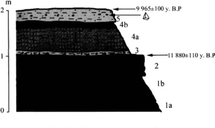
Fig. 4: Stratigraphie section of the Lower Rharbian alluvial deposi ts 1. gravels, 2. sandy silts, 3. clay, 4. reworked travertine, 5. polye- at cote 102. dric structure, 6. carbonated nodules, 7. root marks, 8. Melanopsis, 9. Epipalaeolithic implements.
Lithology: la. silty clay with polyedric structure, lb. silty clay con taining gravels, 2. sandy silt with reworked travertine, 3. sandy silt comprising gastropod shells and roots marks, 4a. sandy silt, 4b. sandy silt with gastropod shells, calcareous nodules and gypsum, 5. sandy silt containing gypsum, calcareous nodules and gastropod shells.
Fig 4 Coupe stratigraphique des dépôts alluviaux du Rharbien ancien à la cote 102
1 graviers, 2 limons sableux, 3 argile, 4 travertin remanié, 5 struc ture polyédrique, 6 nodules carbonates, 7. racines, 8 Melanopsis, 9 Artefacts épipaléohthiques
Lithologie la limon argileux à structure polyédrique, lb limon argileux à graviers, 2 limon sableux à travertin remanié, 3 limon sableux à coquilles de gastéropodes et racines, 4a limon sableux, 4b limon sableux à coquilles de gastéropodes, nodules calcaires et gypse, 5 limon sableux à gypse, nodules calcaires et coquilles de gastéropodes Inner terraces of the Assaka wadi are inset in a 25 to 30 meter deep trench cut through the Soltanian terrace. On their top, they are covered by piedmont slope or by historic and present sequences (fig. 5 and 6). Erosion has sometimes destroyed this terrace so that this formation is not present on the two banks of the present mean-water channel. Thus, from upstream to downstream, we only find it on the left bank at the cote 102 and the cote 65 and on the right one at the cote 50 and at the cote 23. It is only on both banks at Foum Assaka as the main wadi joins the Ocean. The thickness of these accumulations decreases downstream from 1 1 metres to 3 metres. In most of the cases, the last metres of these formations are of historic ages, as the 14C dating at Sidi Messaoud (cote 23) leads us to believe. Finally, between cote 65 and the Fort Oued Noun (fig. 1), recent floods have built gravelly and sandy benches on the margin of the present mean- water channel as in the Tagus river (Benito et al., 1998). These inner terraces are the result of longitudinal floods probably coming from the entire Assaka wadi watershed, unlike the upper fans, which were built by the main tributaries.
The géomorphologie position and the first dating of these sequences show that they were deposited at diffe rent stages of the Moroccan Rharbian (=Holocene) chro nology. Effectively, the Upper Soltanian sequences, over laid by the fans, have been dated by U/Th (on a travertine formation) to 21 600 years BP and the equivalent alluvial sequences of the adjacent fans by 14C between 1 1 800 to 9 900 years BP (two datings). Therefore, the tributaries adjacent fans are from the Upper Soltanian or the Lower
Rharbian. The inner terraces have been dated by 14C from 4 250 ± 70 years BP (Gif. 101065) (one dating at Fort oued Noun) and are from the Middle Rharbian. Finally, one dating of historic and present sequences at the cote 23 (Sidi Messaoud) by 14C gives an age of 280 ± 30 years BP(Gif. 11522).
3 - THE UPPER PLEISTOCENE OR THE LOWER RHARBIAN : THE UPPER FANS
AND THEIR LATERAL EQUIVALENTS At cote 65 (fig. 2 and 3), the adjacent fan consists of brown to red sandy silts and silts with a high content of terrestrial gastropods : Otala sp. and Rumina decollata. Sedimentological studies show high palygorskite and aeo- lian quartz contents. Much of the quartz, with pedogene- sis features, comes certainly from Mediterranean fersialli- tic soils. These analyses demonstrate that these fans have been built from the reworking of both older drier environ ment formations with aeohan quartz and palygorskite con tents (Callen, 1984) and wetter environment formations
with the reworking of red Mediterranean soils.
Alluvial equivalents of these fans are conserved at cote 102 (fig. 4). They overlay the top of the Soltanian terrace and consist of small channel infillings of red to brown silty clays and silts with, in the middle part of the section, fine gravels capped by a carbonated bed rich in reworked travertine fragments. At the base of the carbonated layer, Melanopsis sp. have been dated by 14C from 1 1 880 ±110
years BP (Gif. 11022). At the top of the unit, fragments of ostrich eggs have been dated by 14C from 9 965 ± 100 years BP (Gif. 1 1023). These data show that these depos its were built at the end of the Upper Pleistocene or at the beginning of the Lower Rharbian period. Future datings will aim to confirm this hypothesis. Furthermore, we often found Epipaleolithic implement and pieces of pottery at the top of these formations (fig. 3). These arte facts show that these deposits are contemporary or close to the Upper Palaeolithic occupation. At this time, before 10 000 years BP, the Assaka wadi had not yet entrenched, or only slightly, the Lower Holocene and the Upper Sol tanian accumulations.
In arid and semi-arid Morocco, previous workers and authors (tab. 1) have rarely described Lower Rharbian deposits superimposed or stepped on older formations. Generally, they have studied inner terraces inset in the Soltanian accumulations and succeeding to an erosional phase. Only the Tamdroust wadi comprises a similar orga nisation, with Lower Rharbian deposits stepped on the top of the Soltanian terrace (Ouammou, 1993; Weisrock et al., 1994). These deposits and their situations at the top of the Soltanian terrace display the uniqueness of the lower valley of the Assaka wadi. Thus, in the valleys of the Tamri and Tamghart wadis, Rohdenburg (1977) shows that a 10-metre-thick accumulation set up before 7 380 ± 120 years BP and even before 5 875 ± 175 years BP into a trench cut through Soltanian formations. Weisrock et al. (1991) note that, in the valley of the El Ouarr wadi, silty formations were deposited at 8 430 ±130 years BP, while the deep channel incision period had already started. In eastern Morocco, in the
~1.~2. ~3. t134. 035. • .. 6. 17. ~8. ~ 9.
Fig. 4: Stratigrapbic section of tbe Lower Rbarbian alluvial depos-its at cote 102.
1. gravels, 2. sandy silts, 3. clay, 4. reworked travertine, 5. polye-dric structure, 6. carbonated nodules, 7. root marks, 8. Melanopsis, 9. Epipalaeolitbic implements.
Lithology: la. silty clay witb polyedric structure, lb. silty clay con-taining gravels, 2. sandy sllt with reworked travertioe, 3. sandy silt comprising gastropod shells and roots marks, 4a. sandy silt, 4b. sandy silt witb gastropod shells, calcareous nodules and gypsum, 5. sandy silt containing gypsum, calcareous nodules and gastropod shells.
Fig. 4 : Coupe stratigraphique des dépôts alluviaux du Rharbien ancien à la cote 102.
J. graviers, 2. limons sableux, 3. argile, 4. travertin remanié, 5. struc-ture polyédrique, 6. nodules carbonatés, 7. racines, 8. Melanopsis, 9. Artefacts épipaléolithiques.
Lithologie: la. limon argileux à structure polyédrique, J b. limon argi-leux à graviers, 2. limon sableux à travertin remanié, 3. limon sableux à coquilles de gastéropodes et racines, 4a. limon sableux, 4b. limon sableux à coquilles de gastéropodes, nodules calcaires et gypse, 5. limon sableux à gypse, nodules calcaires et coquilles de gastéropodes.
Inner terraces of the Assaka wadi are in set in a 25 to 30 meter deep trench cut through the Soltanian terrace. On their top, they are covered by piedmont sI ope or by historic and present sequences (fig. 5 and 6). Erosion has sometimes destroyed this terrace so that this formation is not present on the two banks of the present mean-water channel. Thus, from upstream to downstream, we only find it on the left bank at the cote 102 and the cote 65 and on the right one at the cote 50 and at the cote 23. It is only on both banks at Foum Assaka as the main wadi joins the Ocean. The thickness of these accumulations decreases downstream from Il metres to 3 metres. In most of the cases, the last metres of the se fonnations are of historic ages, as the 14C dating at Sidi Messaoud (cote 23) leads us to believe. Finally, between cote 65 and the Fort Oued Noun (fig. 1), recent floods have built gravelly and sandy benches on the margin of the present mean-water channel as in the Tagus river (Benito et al., 1998). These inner terraces are the result of longitudinal floods probably coming from the entire Assaka wadi watershed, unlike the upper fans, which were built by the main tributaries.
The geomorphologic position and the first dating of these sequences show that they were deposited at diffe-rent stages of the Moroccan Rharbian (=Holocene) chro-nology. Etfectively, the Upper Soltanian sequences, over-laid by the fans, have been dated by UlTh (on a travertine formation) to 21 600 years BP and the equivalent alluvial sequences of the adjacent fans by 14C between Il 800 to 9 900 years BP (two datings). Therefore, the tributaries adjacent fans are from the Upper Soltanian or the Lower
211
Rharbian. The inner terraces have been dated by J4C from 4 250 ± 70 years BP (Gif. 101065) (one dating at Fort oued Noun) and are from the Middle Rharbian. Finally, one dating of historic and present sequences at the cote 23 (Sidi Messaoud) by J4C gives an age of280 ± 30 years BP (Gif. 11522).
3 - THE UPPER PLEISTOCENE OR THE LOWER RHARBIAN : THE UPPER FANS
AND THEIR LATERAL EQUIVALENTS At cote 65 (fig. 2 and 3), the adjacent fan consists of brown to red sandy silts and silts with a high content of terrestrial gastropods : Otala sp. and Rumina decolla/a.
Sedimentological studies show high palygorskite and aeo-lian quartz contents. Much of the quartz, with pedogene-sis features, cornes certainly from Mediterranean fersialli-tic soils. These analyses demonstrate that these fans have been built from the reworking ofboth older drier environ-ment formations with aeolian quartz and palygorskite con-tents (Callen, 1984) and wetter environment formations with the reworking of red Mediterranean soils.
Alluvial equivalents ofthese fans are conserved at cote 102 (fig. 4). They overIay the top of the Soltanian terrace and consist of small channel infillings of red to brown silty clays and silts with, in the middle part of the section, fine gravels capped by a carbonated bed rich in reworked travertine fragments. At the base of the carbonated layer,
Melanopsis sp. have been dated by J4C from Il 880 ± 110 years BP (Gif. 11022). At the top of the unit, fragments of ostrich eggs have been dated by J4C from 9 965 ± 100 years BP (Gif. 11023). These data show that these depo-sits were built at the end of the Upper Pleistocene or at the beginning of the Lower Rharbian period. Future datings will aim to confirm this hypothesis. Furthermore, we often found Epipaleolithic impIe ment and pieces of pottery at the top of these formations (fig. 3). These arte-facts show that these deposits are contemporary or close to the Upper Palaeolithic occupation. At this time, before 10 000 years BP, the Assaka wadi had not yet entrenched, or only slightly, the Lower Holocene and the Upper Sol-tanian accumulations.
In arid and semi-arid Morocco, previous workers and authors (tab. 1) have rarely described Lower Rharbian deposits superimposed or stepped on older formations. Generally, they have studied inner terraces inset in the Soltanian accumulations and succeeding to an erosional phase. Only the Tamdroust wadi comprises a similar orga-nisation, with Lower Rharbian deposits stepped on the top of the Soltanian terrace (Ouammou, 1993; Weisrock
et al., 1994). These deposits and their situations at the top of the Soltanian terrace display the uniqueness of the lower valley of the Assaka wadi. Thus, in the valleys of the Tamri and Tamghart wadis, Rohdenburg (1977) shows that a 10-metre-thick accumulation set up before 7 380 ± 120 years BP and even before 5 875 ± 175 years BP into a trench cut through Soltanian formations. Wcisrock et al. (1991) note that, in thc valley of the El Ouarr wadi, silty formations were deposited at 8 430 ± 130 years BP, while the deep channel incision period had already started. In eastern Morocco, in the
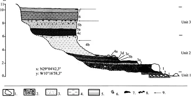
m 11- 10- 6- 4- OJ Unit 3 x: N29°04'42,3" y:W10°16'58,3" Unit 2 Unit 1 6. 7. 9.
Fig. 5: Stratigraphie section of the lower terrace at cote 102.
1. block, 2. pebbles, 3. sand, 4. silt, 5. lamellar structure, 6. Otala sp , 7. Unio sp., 8. carbonated nodules, 9. future I4C datings. Unit 1: basement of the Soltanian (Wiirmian) formations: 1- Pebbles mixed into a carbonated matrix 2- Consolidated silt.
Unit 2: Lower Rharbian deposits:
1: Pebble sheet including metric blocks into a gravely matrix. 2: Consolidated sandy silt (10 YR 8/4), containing mainy root marks, gastropods shells, travertine fragments and carbonated marks. 3a: consolidated pink (7,5 YR 7/4) gravely sand including Melanopsis, Rumina decollata and Unio sp. shells and travertine fragments. 3b: Pink (7,5 YR 7/4) silt including schist gravels, gastropods fragments and root marks. 3c: Heterometric pebble sheet. 3d: Pink (7,5 YR 7/4) coarse sand with Unio and Melanopsis shells. 4a: Pebble sheet with travertine bloks. 4b: Brown (7,5 YR 6/4) silt with charcoals fragments, schist gravels and at the top Otala sp. Shells. 4c: Brown (7,5 YR 6/4) silt with many root marks and
charcoals fragments.
Unit 3: Historic and modern deposits: 5a: gravel beds, 5b: Pink (7,5 YR 7/4) silt with root marks, charcoal beds, calcareous nodules, Otala sp., shells and near the top Unio sp. shells.
6: Pink (7,5 YR 7/4) silt, 7: Reddish yellow (5 YR 7/6) silt with lamellar structure, root marks, charcoal fragments and schist gravels. Fig 5 Coupe stratigraphique de la basse terrasse à la cote 102
1 bloc, 2 galets, 3 sable, 4 limon, 5 structure lamellaire, 6 Otala sp , 7 Unio sp , 8 nodules carbonates, 9 datations I4C en cours de réalisation Unite 1 base de la terrasse Soltamenne
1 Galets emballés dans une matrice carbonatée 2- Sût consolidé Unité 2 Dépôts du Rharbien inférieur
1 Nappe de galets a blocs métriques dans matrice graveleuse 2 Sable limoneux consolidé (10 YR 8/4), à traces de racines, coquilles de gastéropodes, fragments de travertin et taches carbonatées 3a Sable graveleux consolidé rose (7,5 YR 7/4) à Melanopsis, Rumina decollata et Unio et fragments de travertin 3b Limon rose (7,5 YR 7/4) à graviers schisteux, fragments de gastéropodes et traces de racines 3c Nappe de galets hétérométnques 3d Sable grossier rose (7,5 YR 7/4) à Unio et Melanopsis 4a Nappe de graviers à blocs de travertin 4b Limon brun (7,5 YR 6/4) à charbon de bois, gravier de schiste et, au sommet, coquilles d 'Otala sp 4c Limon brun (7,5 YR 6/4) avec traces de racines et charbons
Unité 3 Dépôts historiques et modernes 5a lits de gravier, 5b Limon rose (7,5 YR 7/4) a traces de racines, lits de charbon, nodules calcaires, Otala sp , et près du sommet, coquilles d'Unio 6 Limon rose (7,5 YR 7/4), 7 Limon rouge jaune (5 YR 7/6) à structure lamellaire, traces de racines, charbons et graviers schisteux
Oujda mountains, in the Charef, Ouiyyane and Al-Gazmir wadis watersheds, Wengler (1993) analysed discordant deposits on Upper Soltanian formations set up between 11 290 ± years BP and 12 120 ± 170 years BP, inset in a 4 to 6 metres deep trench cut. The same situation has been demonstrated by Barathon et al. (2000) in the Kert wadi valley, where an organic sequence has been dated to 12 039 ± 221 years BP. This formation constitutes the substratum of the Upper Rharbian terrace of the Kert wadi valley. On the Atlantic coast, 100 km to the North of the Assaka wadi, Ouammou ( 1 993) and Weisrock et al. ( 1 994) noted a carbonate silty level dated by 14C to 10 880 ± 140 years BP, at the top of the Soltanian accumulations and prior to the channel incision period.
These different works show that the Lower Rharbian deposits are rare in arid and semi-arid Morocco. This period often corresponds to a channel incision phase or to the sedimentation of an inner terrace. However, on both sides of the Anti-Atlas Mountains, in the Assaka wadi and in the Tamdroust wadi (Ouammou, 1993; Weisrock et al., 1994), the Lower Rharbian formations are
posed on the Upper Soltanian terrace. This situation indi cates that the geodynamic context was different during the Lower Rharbian in Southern Morocco: adjacent fans represent a period during which the discharges of the tr ibutaries were dominant in the area.
However, the comparison to other Moroccan sites shows the uniqueness of the Upper Pleistocene or Lower Rharbian deposits of the Assaka wadi that are mainly associated with tributary sediments and correspond to adjacent fans. Andres (1977), in the Jbel Bani, near the studied area, described the formation of red soils between 13 000 and 7 000 years BP, which were eroded and trans ported by wadis and gullies to form alluvial fans. We can suppose that similar processes could be applied to the upper fans of the Assaka wadi: red soil formation during a wetter period and a phase of aridity at the transition Pleistocene-Holocene (Rognon, 1980 and 1987; Nichol son and Flohn, 1980) would produce denudation of the slopes and erosion of red soil by gullies and run-off and finally the main tributaries built the adjacent fans during the return of wetter conditions.
m Il 10 8 6 4 2 o x: N29°04'42,3" y: W 10° 16'58,3" Unit 3 Unit 2 1i!:J!:!5i~L.)' Unit 1
lISJl.
1m2
.
~ L.:..:..:.,j 3.1
-=-
1
4.~5
.
~ 6. . . . 7 . .,.. 8. - 9.Fig. 5: Stratigrapbie section oftbe lower terraee at cote 102.
1. bl(J(k, 2. pebbles, 3. sand, 4. silt, 5. lamellar structure, 6. Otala sp., 7. Unio sp., 8. carbonated nodules, 9. future I·C datings.
Unit 1: basement oftbe Soltanian (Würmian) formations: 1- Pebbles mixed into a carbonated matrix 2- Consolidated silt. Unit 2: Lower Rbarbian deposits:
1: Pebble sheet including metrie bloeks into a gravely matrix. 2: Consolidated sandy silt (10 YR 8/4), eontaining mainy root marks, gastropods
sbells, travertine fragments and carbonated marks. 3a: consolidated pink (7,5 YR 7/4) gravely sand including Melanopsis, Rumina decollata
and Unio sp. sbells and travertine fragments. 3b: Pink (7,5 YR 7/4) silt including sebist gravels, gastropods fragments and root marks. 3e:
Heterometrie pebble sbeet. 3d: Pink (7,5 YR 7/4) coarse sand with Unio and Melanopsis sbells. 4.: Pebble sbeet witb travertine bloks. 4b: Brown
(7,5 YR 6/4) silt witb ebarcoals fragments, scbist gravels and at tbe top Otala sp. Sbells.4e: Brown (7,5 YR 6/4) silt witb many root marks and
ebarcoals fragments.
Unit 3: Historie and modern deposits: 5a: gravel beds, 5b: Pink (7,5 YR 7/4) silt witb root marks, ebareoal beds, ealcareous nodules, Otala sp.,
sbells and near tbe top Unio sp. sbells.
6: Pink (7,5 YR 7/4) silt, 7: Reddisb yellow (5 YR 7/6) silt witb lamellar structure, root marks, cbareoal fragments and scbist gravels.
Fig. 5 " Coupe stratigraphique de la basse terrasse à la cote 102.
1. bloc, 2. galets, 3. sable, 4. limon, 5. structure lamellaire, 6. Otala sp., 7. Unio sp., 8. nodules carbonatés, 9. datations NC en cours de réalisation. Unité 1 " base de la terrasse Soltanienne.
1. Galets emballés dans une matrice carbonatée. 2-Silt consolidé. Unité 2 " Dépôts du Rharbien inférieur,'
1: Nappe de galets à blocs métriques dans matrice graveleuse. 2: Sable limoneux consolidé (JO YR 8/4), à traces de racines, coquilles de gastéropodes, fragments de travertin et taches carbonatées. 3a " Sable grave/eux consolidé rose (7,5 YR 7/4) à Melanopsis, Rumina decollata et Unio etfragments de travertin. 3b : Limon rose (7,5 YR 7/4) à graviers schisteux, fragments de gastéropodes et traces de racines. 3c: Nappe de galets hétérométriques. 3d,' Sable grossier rose (7,5 YR 7/4) à Unio et Melanopsis. 4a " Nappe de graviers à blocs de travertin. 4b: Limon brun (7,5 YR 6/4) à charbon de bois, gravier de schiste et, au sommet, coquilles d 'Otala sp. 4c " Limon brun (7,5 YR 6/4) avec traces de racines et charbons.
Unité 3 : Dépôts historiques et modernes: 5a : lits de gravier, 5b " Limon rose (7,5 YR 7/4) à traces de racines, lits de charbon, nodules calcaires, Otala sp., et près du sommet, coquilles d'Unio.
6: Limon rose (7,5 YR 7/4), 7,' Limon rouge jaune (5 YR 7/6) à structure lamellaire, traces de racines, charbons et graviers schisteux.
Oujda mountains, in the Charef, Ouiyyane and AI-Gazmir wadis watersheds, Wengler (1993) analysed discordant deposits on Upper Soltanian formations set up between 11 290 ± years BP and 12 120 ± 170 years BP, inset in a 4 to 6 metres deep trench eut. The same situation has
been demonstrated by Barathon et al. (2000) in the Kert
wadi valley, where an organic sequence has been dated to 12 039 ± 221 years BP. This formation constitutes the substratum of the Upper Rharbian terrace of the Kert wadi valley. On the Atlantic coast, 100 km to the North of the
Assaka wadi, Ouammou (1993) and Weisrock et al. (1994)
noted a carbonate silty level dated by 14C to 10 880 ± 140
years BP, at the top of the Soltanian accumulations and prior to the channel incision period.
These different works show that the Lower Rharbian deposits are rare in arid and semi-arid Morocco. This period often corresponds to a channel incision phase or to the sedimentation of an inner terrace. However, on both sides of the Anti-Atlas Mountains, in the Assaka wadi
and in the Tamdroust wadi (Ouammou, 1993; Weisrock et
al., 1994), the Lower Rharbian formations are
superim-posed on the Upper Soltanian terrace. This situation indi-cates that the geodynamic context was different during the Lower Rharbian in Southem Morocco: adjacent fans represent a period during which the discharges of the tri-butaries were dominant in the area.
However, the comparison to other Moroccan sites shows the uniqueness of the Upper Pleistocene or Lower Rharbian deposits of the Assaka wadi that are mainly associated with tributary sediments and correspond to adjacent fans. Andres (1977), in the Jbel Bani, near the studied area, described the formation of red soils between 13 000 and 7 000 years BP, which were eroded and trans-ported by wadis and gullies to form alluvial fans. We can suppose that similar processes could be applied to the upper fans of the Assaka wadi: red soil formation during a wetter period and a phase of aridity at the transition Pleistocene-Holocene (Rognon, 1980 and 1987; Nichol-son and Flohn. 1980) would pro duce denudation of the slopes and erosion of red soil by gullies and mn-off and finally the main tributaries built the adjacent fans during the retum of wetter conditions.
213
IKyBP 3KvBP
8,5 Ky BP
Aggradation. Erosion.
Tab. 1: Holocene sedimentation and channel incision phases in the lower section of the Assaka wadi valley, in semi-arid and arid Morocco and in Maghreb. Tab 1 . Phases de sédimentation et d 'incision holocènes dans la basse vallée de l'oued Assaka, au Maroc semi-ande et aride et au Maghreb
These results show that there were wetter conditions in South Morocco during the transition Upper Pleisto- cene-Holocene associated with red soil development and probably with more regular discharges than at present. However, the climate became drier during the Lower Holocene, sufficiently to denude the slopes, where during big storms, gullies and run-off supplied the tributaries of the Assaka wadi with sandy silts and developed adjacent fans. Ballais (1991) and Ballais and Benazzouz (1994) have reached the same conclusion in Southern Tunisia and in Eastern Algeria. Thus in the Nemencha, the Lower Holocene reflects wetter conditions about 10 000 years BP. Petit-Maire et al. (1991) have noted that there was a development of the lakes in Southern Tunisia at 8 000 years BP.
In the lower valley of the Assaka wadi, during the Lower Rharbian, the development of adjacent fans pro bably modified the hydrologie conditions. Effectively, fans certainly dammed the Assaka wadi channel and bounded the floods coming essentially from the tributary watersheds. This situation has already been noted by Estorges et al. (1969) in Libya. Near the present city of Tiliouine, upstream to the Assaka gorges (fig. 1), a lake developed behind an alluvial dam, probably
ding to an adjacent fan like those that overlay the Solta- nian terrace. Organic matter contained at the top of the accumulation have been dated by 14C to 14 090 ± 120 years BP (Gif. 11209).
4 - A DEEP CHANNEL INCISION PERIOD BETWEEN THE LOWER RHARBIAN
AND THE MIDDLE RHARBIAN
The generalized channel incision period that cut the Lower Rharbian fans and the Soltanian terrace is still not well dated (fig. 2 and 4). The depth cut is about 20 to 30 metres. It seems that this erosion phase took place after 9 965 ± 100 years BP, according to the 14C age of ostrich eggs found at the top of the stratigraphie section of cote 102 (fig. 4) and even after 7 815 ± 80 years (Gif. 1 1643), according to the 14C age of charcoal fragments extracted from an Epipalaeolithic site occupying the top of pied mont slope deposits superimposed and eroding the top of the Soltanian terrace. So between 10 000 and 8 000 years BP, run-off on slopes was still active and the ero sion phase had still not started. We hope that future 14C datings at cote 102 (fig. 5) will give us more precision about the age of the channel incision period.
IKy BP 3 h:~' BP 8,5 h:y BP Chrollology Present and historie limes Upper Rharbian Middle Rharbian Lowcr Assaka ",adi c::::::::l 2J10 ± 30 )'r BP ?
~
4""'Oy,8P i .) L. .. : ... ..J 9%5% IOOyrBP Il 880 ± 110 yr BP 213 Morocco E:J Cl "'ob ~.h .. ·.dl: .. adl: ~1"" Y'-no vr -B(' 8r 101 l>}8P Tamri )r HP ,,! .• d~ '" Maghreb Œl El Abri ... adi (Tu~ijia) ; 610 Y' 8P (font .. <f el .. 191)) - - - - --II (·htrl. , . . di Mat,lf .. ldi~(
:~
j
U~) (~~';:~:'~.m.
~
5.' (Tuniùa) yr 8 C!:!l 6,1 " 6.1 10.: ,r BP >rBP l'\<cueb - ... èlï ·-·-·-·~---'r:awn(h. (AIII.ri.): p.li. -:\10, .. ",./ .. 19'11 (rual.I.) 1.8 K .r.!JIY-_ ... _._ 11.6 K Y' BI' Rharbian...
-e.
;
? .~, - - - -. . ~~~ . . . ~I~ . . . ----~ ! . i t::::::j 14090:l: 120 yr BP Upper Oujda l'anMIro",t ;\1ount.'nlo_ ... dl., W.nckr(199JI O ... m.,..,. "~r1 ... dl. 8ara'~un '" .1. Soltanian (19931 UOOO) Aggradation. ~ EroslOn. .Tab. 1: Holocene sedimentation and channel incision phases in the lower section of tbe Assaka wadi valley, in semi-arid and arid Morocco and in Maghreb.
rab. 1 : Phases de sédimentation et d'incision holocènes dans la basse vallée de l'oued Assaka, au Maroc semi-aride et aride et au Maghreb.
These results show that there were wetter conditions in South Morocco during the transition Upper Pleisto-cene-Holocene associated with red soil development and probably with more regular discharges than at present. However, the climate became drier during the Lower Holocene, sufficiently to denude the slopes, where during big stonns, gullies and run-off supplied the tributaries of the Assaka wadi with sandy silts and developed adjacent fans. Ballais (1991) and Ballais and Benazzouz (1994) have reached the same conclusion in Southern Tunisia and in Eastern Algeria. Thus in the Nemencha, the Lower Holocene reflects wetter conditions about 10 000 years BP. Petit-Maire et al. (1991) have noted that there was a development of the lakes in Southern Tunisia at 8 000 years BP.
In the lower valley of the Assaka wadi, during the Lower Rharbian, the development of adjacent fans pro-bably modified the hydrologic conditions. Effectively, fans certainly dammed the Assaka wadi channel and bounded the floods coming essentially from the tributary watersheds. This situation has already been noted by Estorges et al. (1969) in Libya. Near the present city of Tiliouine, upstream to the Assaka gorges (fig. 1), a lake developed behind an alluvial dam, probably
correspon-ding to an adjacent fan like those that overlay the Solta-nian terrace. Organic matter contained at the top of the accumulation have been dated by 14C to 14 090 ± 120
years BP (Gif. 11209).
4 - A DEEP CHANNEL INCISION PERIOD BETWEEN THE LOWER RHARBIAN
AND THE MIDDLE RHARBIAN
The generalized channel incision period that cut the Lower Rharbian fans and the Soltanian terrace is still not weil dated (fig. 2 and 4). The depth cut is about 20 to 30 metres. It seems that this erosion phase took place after 9 965 ± 100 years BP, according to the 14C age of ostrich
eggs found at the top of the stratigraphic section of cote 102 (fig. 4) and even after 7815 ± 80 years (Gif. 11643), according to the 14C age of charcoal fragments extracted
from an Epipalaeolithic site occupying the top of pied-mont slope deposits superimposed and eroding the top of the Soltanian terrace. So between 10 000 and 8 000 years BP, run-off on slopes was still active and the ero-sion phase had still not started. We hope that future 14C
datings at cote 1 02 (fig. 5) will give us more precision about the age of the channel incision period.