A Comparative Analysis of the Park-and-Ride/
Transit-Oriented Development Tradeoff
by Jason Burgess
Submitted to the Department of Urban Studies and Planning in partial fulfillment of the requirements for the degree of
MASTER IN CITY PLANNING at the
MASSACHUSETTS INSTITUTE OF TECHNOLOGY JUNE 2008
© 2008 Jason Burgess. All Rights Reserved.
MASSACHUSE~T -S INSTrTUTrE OF TECHNOLOGY
JUN
2
5 2008
LIBRARIES
The author hereby grants to MIT the permission to reproduce a d-to distribute publicly paper and electronic copies of ýte thesiscument if'whole, or in nart.
Author
/1 Certified by
Department of Urban Studies and Planning
/L
-
May 22, 2008Profes r'P. Christopher Zegras
J
Thesis Supervisor Department of Urban Studies and PlanningAccepted by_
Professor Langley Keyes Chair, MCP Committee Department of Urban Studies and Planning
Park-and-ride provided metro regions with a mechanism to reduce commute-generated vehicle-miles traveled, by capturing vehicles in or near their home communities and allowing their drivers to travel to their destinations via transit. The hypothesis underlying this study is that the loss of commuter parking to transit-oriented development involves a tradeoff of one set of benefits (and costs) for another. By assessing the performance of existing park-and-ride facilities, and comparing the associated costs and benefits with those we might expect from transit-oriented development, decision-makers might make land-use decisions that more effectively advance local and regional goals. To that end, this study sets up a methodology to allow for an "apples-to-apples" comparison of the impacts of park-and-ride and transit-oriented development on regional vehicle-miles traveled. This methodology is flexible in its methods and its application, so that it may be adapted to a range of modeling tools and techniques, available data, and regional contexts. Data collected from commuter rail statigns in the Boston metro region suggests that park-and-ride performance is more a factor of station distance from commuters' destinations than of the position of a station relative to others on the transit line. This result indicates that redevelopment of park-and-ride facilities in the Boston metro region should focus on cost-inefficient facilities in communities nearer to the CBD, where the benefits of transit-oriented development are also often greater.
A Comparative Analysis of the
Park-and-Ride/Transit-Oriented Development
Tradeoff
Jess Burgess
May 2008
Introduction . . . . .. . . . .. .. . . . .. . . . .. .. . .. 9
Chapter 1: Overview of the Transit-Land Use Literature . ... 11
1.1 Park-and-Ride: Benefits, Costs and Problems . ... . . . 12
1.1.1 Benefits of Park-and-Ride ... ... . 12
1.1.2 Questioning the Benefits of Park-and-Ride . ... 16
1.1.3 Park-and-Ride Costs: Development and Operation ... 17
1.2 Park-and-Ride: History & Current Context . ... 18
1.2.1 Humble Beginnings: 1930s-1980 . ... 18
1.2.2 The BoomYears: 1980-2000 ... 19
1.2.3 Management & Operation of Park-and-Ride . ... 19
1.3 Transit-Oriented Development: A Better Use of Transit Station Land? . . . 20
1.3.1 Travel Impacts of TOD ... 21
1.3.2 Issues for TOD ... 22
1.3.3 Climate Change and VMT ... 23
1.3.4 Summary ... ... 25
Chapter 2: Introduction to the Trade-offs Comparison Methodology ... 27
2.1 Process Component: Methodology for Forecasting Demand for Park-and-Ride . . . .... 27
2.1.1 Station Selection ... 28
2.1.2 Catchment Area Definition . ... .. 29
2.1.3 Determining the Population of Potential Users . ... 30
2.1.4 The Demand Parameter ... 30
2.1.5 Estimating Demand for Park-and-Ride Capacity . ... 31
2.1.6 TOD Development Size ... .. 31
2.2 Impact Component: Methodology for Estimating the VMT Effects of Park-and-Ride & TOD ... 31
2.2.1 Estimating the Impact of Park-and-Ride on Commute VMT . . . . 31
2.2.2 Estimating the Impact of TOD on Commute VMT ... 32
2.3 Performance Metrics ... ... 33
Chapter 3: Boston Case Background: Transit System Service and History . . .. 35
3.1 Transit in Boston: MBTA System Overview . ... 35
Table of Contents
3.2 Transit & Parking in Boston, History ... .. 39
Chapter 4: Application of the Tradeoff Comparison Methodology to the Boston C ase . . . 41
4.1 Estimating the VMT Reduction Effect of Park-and-Ride at Case Study Stations . . . 41
4.1.1 Estimating the VMT Reduction Effect of TOD at Case Study Stations 47 4.1.2 Limitations of the Operational Method Employed in Analysis of the Boston Case ... 49
Chapter 5: Analysis Results for Eight Case Study Stations in the Boston Region 51 5.1 Suburban-center Stations ... ... ... .. 56
5.2 Urban Area Stations ... 58
5.3 Sum m ary . . . 61
Chapter 6: Conclusions & Implications for Policy . ... 67
6.0.1 The Components of Decision-Making: Regional Goals & Place-Based Effectiveness ... 68
6.1 Factors Governing Park-and-Ride Performance . ... 69
6.2 Policy Implications ... ... 69
6.2.1 Policy Proposal: Graduated Replacement & Targeted Redevelopment 70 6.2.2 Limitations and Future Research . ... 71
6.3 Beyond the Boston Case ... 71
4.1 Summary of case study stations ... ... 42
5.1 Simulated & Actual Parking Capacities at Case Study Stations ... 51 5.2 Summary of estimated park-and-ride effects on commute-generated VMT . 62 5.4 Lot sizes, daily VMT reductions & cost-effectiveness . ... 63 5.5 Station cost-effectiveness, trip-distance ratio, distance from CBD and share
of CBD-bound commutes ... 63 5.6 TOD densities required to produce VMT effect comparable to park-and-ride 64
List of Figures
1.1 Park-and-ride lot serving a light rail station . ... 14
1.2 Graph of projected VMT and vehicle-emitted CO2. (Source: American Public Transportation Association) ... . . . 24
2.1 M ethodological Outline ... 28
3.1 MBTA subway map (source MBTA.com) . ... 35
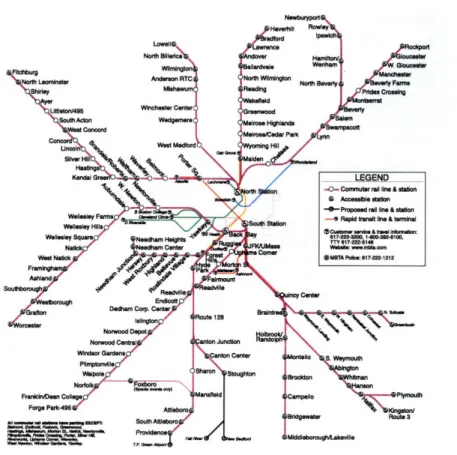
3.2 MBTA commuter rail service map (source: MBTA.com) . . ... 36
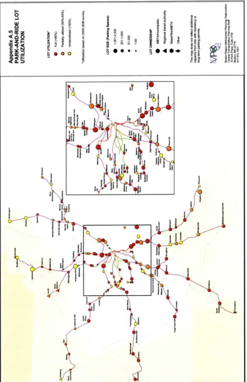
3.3 Map of MBTA park-and-ride facilities and utilization (Source: C.T.P.S.) . 38 4.1 Map of case study stations & catchment areas . ... 42
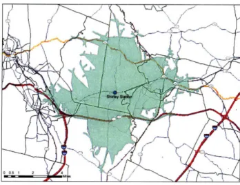
5.1 Map of the Shirley station & simulated catchment area . ... 52
5.2 Map of S. Weymouth station & simulated catchment area ... 53
5.3 Map of Stoughton station & simulated catchment area ... 54
5.4 Map of Wilmington station & simulated catchment area ... . . 56
5.5 Map of Norwood Central station & simulated catchment area ... 57
5.6 Map of West Natick station & catchment area . ... 58
5.7 Map of Lynn station & catchment area ... 60
5.8 Map of West Medford station catchment area . ... . . . 61
Vii1
Introduction
For decades, park-and-ride facilities have been a common sight at rail transit stations in U.S. metropolitan regions (Frost 1974, Noel 1988, Turnbull 2004). Park-and-ride provided metro regions with a mechanism to reduce commute-generated vehicle-miles traveled, by capturing vehicles in or near their home communities and allowing their drivers to travel to their destinations via transit. Park-and-ride is an expensive service for transit agencies to offer, however, and recently a number of metro areas have begun to redevelop former park-and-ride lots to reduce their costs, as well as to provide transit-accessible housing, shopping and office space, a development type commonly referred-to as transit-oriented development (TOD) (Bernick 1997, Cervero 1994, 2001, 2004). The sale of large parcels of land adjacent to rail transit stations has provided transit agencies in these areas with significant windfalls, and has resulted in the conversion of large, often-empty parking lots to vibrant, mixed-use communities, the benefits of which are attractive and clearly visible. The hypothesis underlying this study is that the loss of commuter parking to transit-oriented development involves a tradeoff of one set of benefits (and costs) for another. This tradeoff is context dependent: the exchange of benefits when a blighted, underused parking lot is converted to a healthy community, may be very different than when a well-functioning lot is redeveloped to make way for a neighborhood where no one wants to live. This study attempts to answer the question, What factors govern this tradeoff? If we are able to assess the performance of existing park-and-ride facilities, and compare the associated costs and benefits with those we might expect from TOD, this might allow us to make land-use decisions that more effectively advance local and regional goals.
This study sets up a methodology to allow for an "apples-to-apples" comparison of the impacts of park-and-ride and TOD on regional vehicle-miles traveled (VMT). This methodology is flexible in its methods and its application, so that it may be adapted to a range of modeling tools and techniques, available data, and regional contexts. This is important because of the context-dependent character of the park-and-ride/TOD benefits tradeoff, which may appear different in the New York metro region than it does at the state level in California, or at the level of the U.S. as a nation. The aim of the methodology is to be flexible enough to be adaptable to such varying conditions and modes of analysis.
The tradeoff methodology is then applied to the Boston metro region, using a rigorous case study approach at eight commuter rail stations. This demonstrates an application of the methodology, and provides a set of results with applicability to land-use planning and policy for the regional commuter rail system. The results from the Boston commuter rail case study analysis suggest several implications for transit-land use policies in this region.
much greater reduction in commute VMT than TOD, for a given amount of land area. However the cost of providing station parking is very high, an important consideration for a cost-sensitive transit agency. In general, the results show that park-and-ride facilities perform more cost-effectively in areas further from the CBD, and less effectively in inner-ring communities, where the greater number of transportation options lowers facility performance. This conclusion clarifies somewhat a claim in the park-and-ride literature, that park-and-ride facilities often function best at terminal stations (Turnbull et al., 2004; Kim, 1997). Rather, it appears that, for commuter rail stations in the Boston metro region, park-and-ride performance is more a factor of station distance from commuters' destinations than of the position of a station relative to others on the transit line. This result suggests that redevelopment of park-and-ride facilities should focus on cost-inefficient facilities in communities nearer to the CBD, where demand for housing and commercial development is also likely to be higher.
Chapter 1 provides an overview to the transit-land use literature. Chapter 2 introduces the tradeoff-comparison methodology, outlining its essential structure and suggesting some of the ways in which it might be applied. Chapter 3 briefly lays out the the history and current transit system characteristics for the Boston case study. Chapter 4 demonstrates the application of the tradeoff-comparison methodology to the Boston case, and the techniques employed, as well as the limitations of this approach. Chapter 5 presents the results of the analysis for the eight Boston region case study stations. Following from these results, Chapter 6 suggests some implications for land-use policy at commuter rail stations in the Boston region, and sets the ground for application of the methodology to cases beyond this region.
Chapter 1
Overview of the Transit-Land Use
Literature
Park-and-ride describes an operation that enables travelers to transfer from less-efficient private automobiles to more efficient modes of transportation, typically carpools or mass transit. Drivers park their automobiles at a designated facility and travel via the relatively more efficient mode from that facility to their destination. In the U.S., most large park-and-ride facilities (with capacity >100 spaces) mostly adjoin rail transit stations, and most are owned by transit agencies (Turnbull et al., 2004) - though many urban areas maintain smaller facilities at bus stations or at highway interchanges for carpoolers. The majority of park-and-ride capacity in the U.S. currently exists at rail transit stations, particularly in suburban communities or rural areas (Turnbull et al., 2004; Noel, 1988; Cervero, 1994).
Park-and-ride is considered by some observers to be the best way to extend public transit service, and rail transit in particular, to low-density suburban communities where it would not otherwise be financially feasible to provide service (Pushkarev and Zupan, 1977). Whereas in dense urban areas a majority of transit riders walk to access rail stations or bus stops, in suburban and rural areas, increased distances and decreased safety and comfort for pedestrians put transit services out of reach of most residents. Transit station parking facilities allow commuters to drive to transit stations, leave their cars and continue their commute on transit, effectively extending transit access to populations far beyond the small area within walking distance of a station. This extension of access attracts greater ridership to stations than could occur otherwise, increasing transit agency fare revenues.
Park-and-ride generates benefits for a wide range of groups. Benefits to users may include cost savings, time savings and increased comfort. Benefits to non-users may include reductions in road congestion and airborne pollutants, better land use in urban centers, and economic development region-wide. Park-and-ride already provides these benefits in many U.S. cities, helping them to deal with issues of congestion and air pollution.
However, some researchers question the effectiveness of park-and-ride, citing the costs to operate and develop facilities, and in forgone transit-accessible development opportunities on the land now occupied by parking lots (Parkhurst, 1995; Bernick and Cervero, 1997). Park-and-ride is criticized also for building-in auto dependence, when its goal is to reduce vehicle travel. An alternative land-use, transit-oriented development
- which better capitalizes on the unique value of transit access and seeks to reduce auto dependence - appears in many ways to offer a better future for urban areas. What, then, is the future of park-and-ride, and of transit station land-use? Do transit-oriented development and urban villages offer a better future for metro-regions?
This paper begins from an assumption that neither park-and-ride nor transit-oriented development (nor any other one land-use, for that matter) offer a 'one-size-fits all' best option for station-area land. Rather, the attributes, costs and benefits of each of these uses are better suited to different types places, such that, within the same region, park-and-ride will produce the best results at the lowest cost in one place, while TOD is more effective at another. Metro-regions, then, need to better understand just which characteristics of a place determine the value of each land-use - station parking or TOD - and a policy to induce development of those best uses in their right places. This paper contributes a better understanding of the costs and benefits associated with these competing land-uses, and of some of the characteristics of place that may determine their relative attractiveness. It begins with a brief review of the literature regarding both park-and-ride and transit-oriented development, and a concise history of their development. Then it presents the results of a basic two-part process- and impact-model for eight commuter rail stations in the Boston region, and ends with a discussion of their implications for land-use planning and policy at transit stations.
A second assumption embedded in this paper is the notion that the "best" station-area land-use will be determined as much by the particular goals and plans of a region or a community, as by the effectiveness with which that use can be expected to deliver benefits. This is because park-and-ride and TOD have very different forms and consequences. An urban area with strong growth pressures, a need for new housing, and relatively less congestion and/or air-quality problems might rightly make the choice to develop strictly TOD, as the benefits it provides are themselves more attractive in that region than park-and-ride's benefits. The "best-ness" of one use or another is determined as much by the goals and desires held in a community or region as by its objective efficiency in delivering benefits.
This chapter outlines the discussion of the particular costs and benefits that accompany park-and-ride development, and its wider impacts on cities and regions. It includes a brief history of park-and-ride in the U.S. and in the Boston area, and a look at its functions in the current U.S. urban context, with particular attention to the Boston region. Following is a review of the critical literature and a discussion of the future possibilities for park-and-ride
and transit-area land use, and their implications for cities, energy consumption and climate
change.
1.1 Park-and-Ride: Benefits, Costs and Problems
1.1.1
Benefits of Park-and-Ride
One aspect of park-and-ride development that makes it particularly attractive for cities and public agencies is that it offers a politically palatable solution to common urban problems of traffic congestion and poor air-quality without placing prohibitive restrictions on any
1.1. Park-and-Ride: Benefits, Costs and Problems
activity or group (Meek, 2008). Unlike many transportation demand management (TDM) policy programs, which tend to privilege an activity or group to the disadvantage of another, park-and-ride provides benefits to a wide range of urban constituents, exposing only a limited public to its costs. Unlike conservation measures, which ask people to do without, park-and-ride development seems to solve problems simply by providing a new set of public benefits that the public has the option to enjoy. These benefits are not without costs, but these costs are often obscure or locally-constrained, as will be discussed in § 1.1.3. Benefits to Users
Park-and-Ride service may offer a number of benefits to users, in particular the extension of access to rapid transit service beyond areas from which it is possible to access that service by walk, bike or bus. The effectiveness and importance of this function for suburban residents is visible in surveys of transit riders in cities across the U.S. One study of 34
stations on San Francisco's BART transit system, found that the 90% ridership catchment area for suburban center stations (virtually all of which offered park-and-ride) was on average about 15 times greater than that of downtown stations (Cervero, 2001). This increased catchment area allows suburban center stations to serve a population of similar size to downtown stations, despite a great disparity in population and employment densities between these area types. A similar study, from the Seattle area, found that 85% catchment areas for suburban stations frequently extended for 12 miles or more, along freeways and major arterial roads (Turnbull et al., 2004).
Park-and-ride is critical to transit systems' ridership outside of the urban core. A large share of transit riders boarding at suburban-area stations access those stations via park-and-ride: 39% of Bay Area Rapid Transit (BART) rail transit riders reported using a BART park-and-ride facility to access the system (Turnbull et al., 2004), 55% of ridership on Chicago's Metra regional rail service used park-and-ride (Ferguson, 2000, in Turnbull, 2004), and on the Lindenwood High Speed Line between Philadelphia and the New Jersey suburbs, 57% of riders were found to have utilized a park-and-ride facility (Ellis, Burnett and Rassam, 1971, in Turnbull, 2004). These data reflect the importance of park-and-ride to suburban rapid transit, both for riders and service providers.
Because it widely extends access to transit, park-and-ride service extends many of the benefits that accompany transit access, including: reduced cost of commuting (in fuel, parking, vehicle wear and maintenance costs), faster commute times and increased comfort vs. driving, amenities at facilities/stations, and others. Demand for park-and-ride service is greater at facilities offering more and better benefits to users (TCRP rpt. 95 ch. 3). As one might expect, certain benefit types are more important to park-and-ride users than others. The results of user preference surveys conducted by several major transit agencies and others reveal that the greatest incentives for park-and-ride use were reduced cost, reduced stress from driving, and faster travel time, though these factors vary in importance among survey sites (Turnbull et al., 2004). A survey of park-and-ride users on the BART system in San Francisco/Oakland, CA, revealed that saving money (53%) was the most cited reason for using park-and-ride, followed by environmental considerations (39%), and avoiding the stress caused by driving to their destination (32%). Saving time compared to driving was cited by only 17% of BART users (results add up to more than 100% as respondents
were asked to select as many factors as they liked) (Lave, Billheimer and McNally, 1997). The most commonly-cited factor among park-and-ride users on the CTA system in Greater Chicago, meanwhile, was a faster commute time compared to driving (35%), followed by dislike for driving (24%), and avoidance of parking costs at their destination (21%) (Urbitran Associates and SG Associates, 1999). While the order of importance among factors for using park-and-ride service varies according to local conditions, the most important of those factors remain generally constant. Reduced cost, faster travel time and less stress/greater comfort compared to driving are the most important factors motivating park-and-ride use in the U.S.
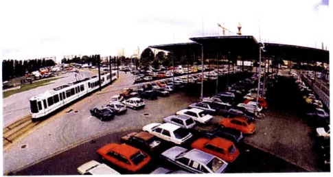
Figure 1.1: Park-and-ride lot serving a light rail station
Benefits to the Region
Park-and-ride development has been driven in large part by the belief that it offers benefits not only for its users, but for municipalities, transit agencies and entire urban populations. Supporters claim that park-and-ride can help to reduce roadway congestion, both on highways and city streets, improve urban air-quality, attractiveness and livability, and generate new economic development opportunities for city center and suburban communities alike. These system-wide benefits stem from several essential functions of park-and-ride: displacement of vehicles and parking capacity from the city center to the suburban fringe; a reduction in VMT attributable to shorter commute trips; and expansion of transit accessibility, particularly in low-density suburban areas.
The displacement of parking capacity from the city center to outlying communities produces a number of benefits for municipalities and urban residents. By providing parking capacity in lower-density areas outside of the city center, park-and-ride reduces the need for parking in dense urban areas, where the value of land is greater. Parcels that were formerly needed for parking are freed up for development, creating job and economic growth, new amenities for residents and a more attractive and vibrant city center.
Fewer parking spaces in urban areas, and additional parking capacity at suburban transit stations, means that many commuters must leave their vehicles in their home communities.
1.1. Park-and-Ride: Benefits, Costs and Problems
To most observers, this is the most important effect of park-and-ride for cities. By keeping thousands (or tens of thousands, as in Boston and many other large cities) of vehicles in their home communities everyday, park-and-ride reduces peak hour demand for highway capacity and congestion throughout the metropolitan area.
Another effect of shorter commute trips by auto modes is an air-quality benefit due to the reduction in VMT and vehicle emissions. Because it can significantly reduce driving distances, park-and-ride may reduce emissions of carbon dioxide (CO2) and air pollutants
including hydrocarbons (HC), nitrogen oxide (NOx) and carbon monoxide (CO). But, due to the cold-start effect, whereby automobiles emit more pollutants during the first several miles of driving, overall reductions in airborne pollutants will be less than the reduction in vehicle miles. This is because, though park-and-ride reduces trip distances, it does not reduce the number of trips. HCs, CO and NOx remain lower in the atmosphere and relatively near to their point of emission. This means that airborne pollutants, like parking capacity, can be displaced, somewhat, by transit station parking. Fewer vehicles in city center areas leads to a reduction in local air pollutants downtown, by capturing vehicles in their home communities, outside the center. However, another consequence is that vehicle concentrations at transit station parking facilities can have significant negative impacts on local air quality in these areas. Cold starts aren't as much of a problem for CO2 emissions; VMT reductions from park-and-ride result directly in lower CO2 emissions.
This is encouraging, and suggests that park-and-ride expansion may be an effective way to significantly reduce transportation sector carbon emissions, a critical task in addressing global climate change.
It should be noted that park-and-ride alone is not a solution at the scale of the challenge. There are more than 60 million vehicle-miles traveled in the Boston region everyday, and growing (C.T.P.S., 2005). Park-and-ride expansion will never achieve the scale of reductions that are necessary. 1 Park-and-ride expansion in the Boston region between
1990 and 2000 was outpaced by growth in VMT 12-to-1 6.2.
Park-and-ride facilities are critical elements in transit service expansion in U.S. cities. Facilities themselves often operate at a financial loss to transit agencies - because of low (or no) cost to park, lots attract less in revenue than they require to build and operate
-but they serve as critical ridership attractors in suburban areas. In areas where residential and employment densities are low, and few would-be riders are able or willing to walk to access transit services, park-and-ride facilities extend access to transit to thousands more potential riders. Pushkarev and Zupan analyzed the fiscal viability of different types of transit services in areas of varying density, and determined that rapid rail transit required a minimum residential density of 12 dwelling units per acre (light rail service requires 9 d.u./acre) in order to attract sufficient ridership to support the service. Commuter rail, however, which in their analysis operates fewer trains than light- and and heavy-rail transit (which most often operate with continual frequent service throughout the day), and may be served by park-and-ride facilities, is viable at densities as low as 1-2 d.u./acre. Assuming between 10 and 20 park-and-ride trips are generated per square mile per day, on commuter rail service, a ridership catchment area of 7-12 square miles is sufficient to provide the number of riders needed to achieve service viability (Pushkarev and Zupan, 1977).
A recent study of rapid light rail expansion across many North American cities showed that park-and-ride facilities are an integral part of transit system expansions (Kim, 1997;
Baum-Snow and Kahn, 2000). This integral role is easy to understand: the dense urban centers in America for the most part already operate rapid transit systems, so expansions will occur largely in lower-density areas, outside of these centers (commuter rail expansion in the Boston, New York City and Philadelphia regions), or as new rail systems in younger, faster-growing metro areas (such as Houston, Phoenix and Portland) that are relatively low-density throughout the urban area. This outward growth of transit service expansion mirrors the population movement outward from urban centers, to the suburbs and outlying areas. Park-and-ride provides a ready-made solution to the problem of greater home-to-station distances in low-density areas, particularly as vehicle ownership levels tend to be higher than average in these suburban communities (Kim, 1997). As federal legislation and public sentiment begin to push cities to provide quality alternatives to auto travel, despite the mostly low-density, auto-dominated American land-use context, park-and-ride has emerged as one of the most viable strategies to expand transit services and use (Noel,
1988; Turnbull et al., 2004).
1.1.2
Questioning the Benefits of Park-and-Ride
Recently, several observers have begun to question whether park-and-ride is really able to deliver its promised benefits (Parkhurst, 1995; Meek, 2008). They point out two degrading factors, processes that reduce the amount of actual achievable benefit that station parking can provide. The most-cited processes are trip replacement and cold starts.
Graham Parkhurst, researching park-and-ride facilities in several English cities, suggests that park-and-ride can actually lead to an overall increase in regional VMT, and accompanying increases in traffic congestion and pollutant emissions (Parkhurst, 1995, 2000). The problem, according to Parkhurst, is that when park-and-ride users are removed from highways and downtown streets - their vehicles captured at transit station parking facilities - the new roadway capacity that is opened up in this way is immediately filled in again by other users. It is at its core the classic induced demand problem: increased roadway capacity leads to better traffic flow and faster trips, increasing the utility of roadway travel for all potential users. This increased utility will attract new trips
-Parkhurst suggests that these new roadway trips will be split among commuters switching from other modes (transit, carpool), new trips with beginning- and end-points within the region (intra-region), and new trips simply passing through the region (inter-region) (Parkhurst, 1995). In the absence of any intervention to restrict them, new roadway trips will replace some portion of the trips originally displaced through the implementation of park-and-ride. In the grimmest analyses, trip growth and mode-switching will continue until the utility of roadway travel returns to its previous equilibrium. The result of this would be a net increase in regional travel (and emissions), but no increase in roadway congestion.
Though to this point little research has been done on this subject, one complicating factor in attempts to mitigate induced demand prompted by park-and-ride is that attempts so far have effects that bias against intra-region trips, while largely failing to account for inter-region trips. The most common transportation demand management technique to accompany park-and-ride development, both in the U.S. and Britain has been the reduction or limitation of parking capacity in city centers (Parkhurst, 1995; Meek, 2008; Turnbull
1.1. Park-and-Ride: Benefits, Costs and Problems
et al., 2004). Parking reductions limit the ability of travelers to drive and park at their destination, and have been shown to be an effective way to induce balanced mode split (Cervero, 2001), by increasing the cost (in money and/or time) of driving - a study of Bay Area travel patterns found that access to free parking at their destination was the single most important factor in determining whether area residents would drive or take transit (Cervero, 2004).
The air quality impacts of new trip generation are significantly greater than is evident simply from the growth in VMT. Because of combustion-engine inefficiencies, most automobiles emit air pollutants at a far greater rate during the first several miles of driving than during later miles, once the engine is warmed up. Numerous studies quote the data from an emissions field test of a number of automobiles that found that over the course of a 3 miles trip (similar to the average park-and-ride commute distance to many facilities, though the median trip tends to be somewhat shorter) the automobiles emitted 84% of the HCs and 54% of the NOx as was emitted during a 10 mile trip (Bernick and Cervero, 1997; Cervero, 1994).
1.1.3 Park-and-Ride
Costs:
Development and Operation
The costs of park-and-ride fall loosely into three categories: development and operation, opportunity cost, and non-financial burdens. Development costs include the cost to acquire the land and build the parking facility. Surface parking lots are much cheaper to build than structured parking, but surface parking requires greater land area, and therefore entails a greater opportunity cost for that land. Construction costs remain generally constant throughout a region, but the value of land clearly does not. For this reason, the type of parking (in structured towers or surface lots) often varies according to the value of the land on which it is built.
Construction costs for parking facilities represent a major expense to would-be developers: the Massachusetts Bay Transportation Authority projects per-space costs at roughly $3,000 for surface parking, $25,000 for structured parking (Ron Morgan, 2008, personal communication). -The choice to develop a large parcel of land as park-and-ride often represents a significant opportunity cost to transit agencies. Park-and-ride service does often attract greater transit ridership in low-density areas, but often operates at a net loss for the transit agency (Turnbull et al., 2004).2 Because the land used for a parking facility necessarily has excellent access to transit service, land used for park-and-ride is in many cases attractive to development interests, and could be rented or sold to generate a considerable windfall for the transit agency. Rent data from the Boston region indicates that, for each of the 9 facilities discussed in chapters 4 and 5, the opportunity cost of the land on which the parking is placed is by far the greatest economic cost of providing park-and-ride (Research, 2007a,b).
Land conversion represents another significant cost of developing new park-and-ride facilities. Large surface parking lots are difficult to site in even modestly-dense areas, and so are often developed on the suburban fringe, or in rural areas. Siting facilities on greenfield land can have impacts on open space availability and species habitat.
Development costs are only one part of the local impacts of park-and-ride service; the impacts from facility operation may also be considerable, and can affect whole
communities. Large facilities, with capacity in the thousands of automobiles, can generate traffic congestion on highway on/off ramps and the local street network, causing inconvenience and negative impacts for economic development. All that traffic naturally leads to increased pollutant emissions, particularly when hot-soak effects (continued emissions of HCs for a period of time after a vehicle is turned off) are considered, and may lead to declines in local air-quality. Park-and-ride facilities may also have negative effects on the pedestrian environment, though this impact could be mitigated with better facility design, as is occurring in some areas. Recognizing these burdens, many communities have resisted park-and-ride development. Resistance to facility siting can impose additional political costs to park-and-ride development.
1.2 Park-and-Ride: History & Current Context
1.2.1
Humble Beginnings: 1930s-1980
Park-and-ride emerged organically on the fringes of a number of U.S. cities during the 1930s, as motorists parked their vehicles in fields and empty lots near bus and rail lines, the speed and cost of which, in those times, provided large user benefits compared to commuting by automobile (Noel, 1988). The City of Detroit operated eight small parking lots at gasoline service stations located along bus routes (Bullard and Christiansen, 1983). The first large-scale park-and-ride facility was built by the Long Island Railroad Co. in 1939, on the site of that year's World's Fair (Frost, 1974). Transit companies were largely responsible for the growth of interest in the phenomenon over the next several decades, and by the late 1960s 36 U.S. cities had "ongoing major involvement in some form of park-and-ride activity" (Noel, 1988).
The Federal Highway Act of 1968 inaugurated the involvement of the federal government in the development of park-and-ride facilities. The Act authorized federal involvement and 50% federal funding for a series of demonstration projects located along the federal highway system. The first facility built with federal assistance was a 12-acre site in Woodbridge, NJ, in 1968, and served by the Penn Central Railroad (Ellis, 1971). The Clean Air Act of 1970, and the OPEC embargo in 1973 prompted renewed interest in public mass transit, and with the Emergency Highway Energy Act of 1974 the Federal Highway Administration (FHWA) expanded its role in support of intermodalism and park-and-ride (Noel, 1988). The 1977 and 1978 Amendments to the Federal Clean Air Act, and a coordinated effort by FHWA, the Urban Mass Transit Administration (UMTA) and the Environmental Protection Agency (EPA) set energy conservation, improved air-quality and efficient use of transit as goals for the national transportation sector. Likewise, they mandated that cities seek to meet these goals through Transportation Improvement Programs (TIP), which were now required in order to receive federal funding for transportation projects. Park-and-ride was established as one of several strategies to manage their transportation systems, a requirement under the TIP provision (Noel, 1988). These legislative actions set the policy stage for the past 25 years of park-and-ride development.
1.2. Park-and-Ride: History & Current Context
1.2.2 The Boom Years: 1980-2000
Transit agencies greatly expanded parking capacity at transit stations in many large urban areas between the mid-1980s and the late-1990s. In 1988, cities and transit agencies within California operated 270 intermodal parking facilities, with total capacity of 15,185 parking spaces (Noel, 1988). In 2003, three largest transit agencies in the state - Bay Area Rapid Transit (BART), Metrolink L.A., and Caltrain - together operated 114 facilities, with a total capacity of more than 65,625 parking spaces (B.A.R.T., 2003). Over the course of fifteen years, these three agencies built more than four times the park-and-ride as had previously existed across California (and this figure is generous, as the 1988 figure includes some municipal lots for carpoolers, not located at transit stations).
These parking capacity expansions have in general not outpaced demand for parking at transit stations. Caltrain facilities reported 78% utilization in 1998, and Metrolink L.A. reported 75% utilization in 1999 (Turnbull et al., 2004). Though system-wide utilization data is not available for the BART system, agency reports indicate that demand for parking at BART stations is high, and has forced the agency to plan significant expansions of existing station parking facilities, as well as to plan larger facilities at future stations (B.A.R.T., 2003).
Despite the large-scale capacity expansions undertaken by many large transportation agencies, the lack of sufficient parking at transit stations in suburban communities is a growing concern around Boston and in other metro regions (Long, 2008). In response to increasing demand for station parking, many transit agencies planned larger facilities at new stations (often in low-density areas), but this only solves part of the problem. Commuters are averse to driving any significant distance away from their destination, in order to park and take transit back the other direction (Wang et al., 2004). Demand for parking at inner-ring suburban transit stations cannot be accommodated by facility development at stations further from the CBD, where much expansion and new development currently occurs. The problem of whether to accommodate rising demand for parking, or to develop parking land as TOD for revenue generation and other purposes, is a critical question for transit agencies and municipalities.
1.2.3 Management & Operation of Park-and-Ride
All of the park-and-ride lots operated by the MBTA, as is the case in most places, are operated on a first-come-first-served basis. Once a facility has filled to capacity
-sometimes an hour or more before the last a.m. train departs (C.T.P.S., 2006) - would-be users are forced to find parking elsewhere, or complete their commute by car. In some urban areas, including the Bay Area and Metropolitan New York, programs allowing monthly or daily reservation of park-and-ride spaces are underway; some observers hope that increased certainty of available capacity will induce greater demand for park-and-ride in these areas (Shaheen and Kemmerer, 2007). Slightly more than half of MBTA park-and-ride lots at commuter rail stations; at most facilities this cost is $2/day. A handful of stations in inner-ring communities charge as much as $3/day, but facilities with no cost to park are more common (M.B.T.A., 2006). At the MBTA, which contracts out operations of park-and-ride facilities on its land, revenue from park-and-ride lots covers the cost of
maintenance, but does not generate net revenue for the agency (Ron Morgan, personal communication).
1.3 Transit-Oriented Development:
A Better Use of
Transit Station Land?
Even as park-and-ride has expanded in the last 15 years, many observers of land-use and transportation issues, community development advocates, urban designers and developers have begun to advocate for a shift in the general approach to development of land nearest to transit stations. Transit-oriented development, in general, implies a mixed-use, moderate-to high-density development pattern, emphasizing pedestrian connections between the transit station and the homes and workplaces that make up the community (Cervero, 1994, 2004; Bernick and Cervero, 1997). TOD seeks to enhance walkability (within the community) and transit use (for trips outside of it) through a focus on "the three Ds": density, diversity and design (Cervero, 2001; Newman, 1999). Dense, diverse, well-designed communities are walkable communities, TOD proponents argue, because density and a diversity of uses allow for many of the things that people want and need to be located close together, and well-designed buildings, sidewalks, streets and public areas will be safe, interesting and enjoyable places for residents, local employees and others.
Though the form of each community or new development is unique, a number of ideals and themes are shared across virtually all TODs. Transit stations are frequently given a central position in the community, both physically and figuratively. Because two critical organizing principles of TOD are that it provide a high degree of access to transit for all residents/users, and a high-quality pedestrian environment, all points within the community should be a short walk (no more than 10 minutes or so) from the station. The organization of land-uses often follows a common scheme: civic buildings or major public amenities nearest the center, followed outward by high-density office buildings and residential apartment towers, then moderate density residential and commercial uses
-often as mixed uses within the same buildings, and moderate- to low-density residential (row houses, duplexes) and industrial uses at the fringes of the community (Bernick and Cervero, 1997; Cervero, 2001, 2004).
Because of their focus toward walkability and pedestrian access throughout the community, transit-oriented developments are necessarily fairly small in terms of land area. A number of researchers, as well as planning and engineering firms designing TODs, prescribe to the rule that Americans are generally not willing to walk more than 1/2 mile, and that developments should therefore not extend beyond a 1/2 mile radius of the transit station. Cervero (2001) and others have demonstrated that Americans' willingness to walk is more complex, and depends on factors including pedestrian safety and comfort, as well as the amount of interest generated by points along the route - a popular main street or plaza is thought to generate high interest for the pedestrian, blank walls and empty sidewalks to generate little. Cervero shows that many people are willing to walk distances of a mile or more, if they are safe, comfortable and interested in what surrounds them. But even at this outer limit of willingness to walk, the total area of any single transit-oriented community
1.3. Transit-Oriented Development: A Better Use of Transit Station Land?
must remain fairly small.
1.3.1 Travel Impacts of TOD
According to advocates for TOD, this tight-knit, transit-centered form of development produces a number of benefits, including positive travel effects, community revitalization and development, environmental sustainability, increased real estate values, and, according to some, benefits in increased sociability and public health. Of particular interest for this study are TOD's impacts on travel behavior, particularly on mode split impacts for several trip types: all trips, work trips and home-to-transit station trips (for those travelers using transit).
Supporters of TOD claim that a shift in the dominant land-use paradigm, from sprawling suburban tract housing toward greater density, pedestrian connections and transit accessibility, could produce important transportation benefits for cities and residents. These claims are based largely on data that show that residents of transit-oriented communities
-be they new developments or older communities that fit the "transit-oriented" description
- have a higher transit mode share, particularly for work trips, than residents of other communities, and have higher non-motorized mode shares for other trips (shopping, recreation, etc.) (Bernick and Cervero, 1997; Cervero, 1994). It is intuitive that those who live closer to transit are more likely to travel by transit than those who live further away. The data bear this out: in a study of seven suburban Bay Area communities, all with significant housing within 1/2 mile of the station, and all served by park-and-ride facilities, residents that lived within 1/2 mile of the station were between 5 and 7 times more likely to travel by transit than residents of the same communities, but outside of the 1/2 mile radius (Cervero, 1994). Pushkarev & Zupan (1977) demonstrate that residential density is also an important predictor of transit use. With other factors held constant, and assuming a CBD with a density of employment centers, these authors found that for every 10% increase in residential density (measured in units/acre), transit ridership increased by 6% (Pushkarev
and Zupan, 1977).
Many of these researchers recognize that increases in transit use in transit-oriented communities must be attributed to factors outside of community land use. The critical determining factor for Pushkarev & Zupan, in determining the level of transit service that an urban area could support, is the total size of the downtown, in square feet of commercial space (Pushkarev and Zupan, 1977). Cervero (1994) showed that, for Bay Area residents living within 1/2 mile of a BART station, the availability of free parking at a person's destination was the greatest predictor of whether that person would drive or take transit; Cervero estimated that the likelihood of taking transit increased by 40-50%, if parking at the destination was paid rather than free (Cervero, 1994). Regional factors such as the availability of free parking at destinations, and the size (in commercial area) of the downtown are largely beyond the control of TOD planners. But these factors are important concerns for regions trying to induce changes in travel behavior through the implementation of TOD.
Another critical factor in TOD residents' use of transit was vehicle ownership per household: every available automobile caused the likelihood of traveling by transit to decline by about 10% - for 0-1 auto the value is somewhat above 10%, and declines
slowly for each marginal vehicle (Cervero, 1994). Strikingly, for a Bay Area resident within 1/2 mile of a transit station, the study found that if that resident owned 0 cars, worked in downtown San Francisco and did not have free parking at their destination, there was an 88% likelihood that residents would travel to work by transit. However if that same resident owned 3 cars, worked anywhere outside of the downtown, and had free parking available at work, that likelihood fell to less than 1% (Cervero, 1994). Residential parking requirements and other design elements of TOD zoning can have meaningful effects on residents' travel behavior.
This data indicates that factors such as the availability of parking at destinations, and the overall square footage of commercial space downtown will likely have greater effects on regional transit usage than the proximity of housing to transit. Nevertheless, repeated studies do show that residents living within 1/2 mile of a transit station do often ride transit more frequently than residents further from the station - how much more depending on factors including those above, but also on community land-use diversity and design, and on the quality of transit service at the local station (Cervero, 2004).
1.3.2
Issues for TOD
Whatever TOD's demonstrated or potential mode share impacts for station-area residents, it is out of scale with the problems urban areas face today, in that it cannot be implemented quickly on a wide scale. Without region-wide implementation, TOD's benefits will be confined to a small group of high-income urban residents, and will not achieve meaningful changes in regional travel behavior.
It is a clear, but not often discussed, fact that any large-scale shift toward transit-oriented development will occur slowly, over many decades at least. The present form of our metro-regions, and the tremendous amount of new and relatively young housing stock in suburban and outlying communities will be with us for fifty years or more. A greater issue than the building stock, in many places, would be the need for massive new rapid-transit service expansions. Fast growing areas in the South and West, cities such as Phoenix, Dallas, Atlanta and Las Vegas, would require service extensions magnitudes of scale larger than what exists currently, in order to extend service to residential areas and expand capacity to accept ridership increases. Even Northeastern cities with established subway and commuter rail systems would need major expansions, as most of these systems already operate at or near their designed capacities. The infrastructure and urban form changes required to enable widespread transit-oriented development will be costly, and will require decades to build.
But work cannot begin on these changes without another critical ingredient: consumer demand. Residential consumers must express strong preference for dense, transit-accessible communities, rather than the wide lawns and roadways of the typical suburban development. TOD proponents suggest that a greater demand exists for the benefits of dense, diverse, well-designed communities than most developers or others realize (Cervero, 1994). But urban form does not reflect this demand in U.S. cities, which, between 1990 and 2000 continued to grow in area more quickly than in population, allowing more and more space per person (Census, 2000). Not until American attitudes towards standards of community desirability change, and until this change is
1.3. Transit-Oriented Development: A Better Use of Transit Station Land? 23 demonstrated effectively to the development community and policymakers, will it be possible to beginning the work of implementing TOD on a scale sufficient to the challenges confronting our urban areas.
Transit-oriented development does not need to be the urban dominant form in order to have effects on VMT and air-quality, but targeted implementation of TOD in some cases raises issues of equity and exclusion. In so far as TOD design discourages driving in order to promote non-motorized and transit modes, it simultaneously restricts access to local amenities - including the local transit station - to those able to get there without a car. This poses problems for social equity and transit, as it excludes the majority of urban residents who live outside of a comfortable walking distance to transit and thereby restricts the pool of potential transit riders. These problems are exacerbated in situations where housing prices closest to the transit station are significantly greater than in less transit-accessible areas (as is the case in many cities with high-quality transit systems). In such cases, access to transit is restricted to those who are able to pay for it - in the form of higher housing costs - and often excludes those who are arguably in greatest need of transit services.
While some buyers are buyers are attracted to transit-oriented communities because of access to transit, many developers have sought to bolster this market by providing high-end furnishings and luxury amenities, and raising the cost of housing in these areas beyond the premium for transit accessibility. This problem is two-fold, in that it deepens the exclusion of lower- or middle-income groups from transit-accessible areas, while bringing into these areas the people who can most afford to (and therefore are the most likely to) drive. But as parking facilities are converted to high-end housing, and higher prices exclude more people from that housing, the impacts of that exclusion could pose significant negative impacts for regional transportation patterns and air-quality.
1.3.3
Climate Change and VMT
Global climate change is among the most significant challenges facing the world today. The transportation sector is the largest end-use and fastest-growing source of U.S. CO2
emissions (EPA, 2006; E.I.A., 2006). Between 1990 and 2003, CO2 emissions from
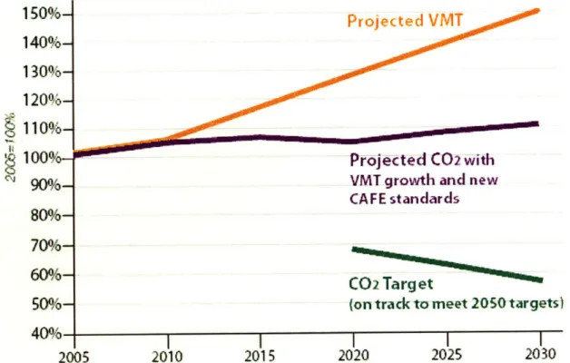
the transportation sector grew from 1509.3 teragrams (Tg; 1 teragram is equivalent to 1 megatonne) to 1866.7 Tg, a 24% increase. As Figure 1.2 shows, despite anticipated fuel efficiency improvements, U.S. EPA estimates that transportation sector CO2 emissions will continue to grow in the future, by 48% between 2003 and 2050 (EPA, 2006). This growth in transportation sector emissions is directly attributable to steep growth in VMT over the same period. Between 1980 and 2007, total U.S. VMT has increased at nearly three times the rate of population growth, and more than double the rate of new vehicle registrations (Reconnecting America, 2008). Growth in VMT is attributable to a variety of factors, but chief among them are today's sprawling pattern of development, relatively high per capita GDP and the consistent underpricing of driving-related resources (be they fuel, roadway space, parking, or others). If these trends continue, the 59% VMT growth between 2007 and 2030 will greatly surpass any gains in vehicle fuel efficiency technology (as the EPA model also predicts) (ibid.). Simultaneous to this sustained growth in VMT and transportation sector GHG emissions, cities, states and regions in the U.S. have begun to
take legislative action against climate change, by setting ambitious targets for the reduction of carbon emissions. Many of these target agreements call for overall reduction of carbon emissions (from all sectors) to 1990 levels by 2020, and to 60-80% below 1990 levels by 2050 as called for by the Intergovernmental Panel on Climate Change (IPCC, 2007). These targets - which according to scientific consensus are absolutely necessary to avoid crossing over an ecological tipping point, beyond which catastrophic changes are likely to occur - stand virtually no chance of being met, should current trends of VMT and associate emissions increases continue.
Projected VMT
Projected C02 with
VMT growth and new
CAFE standards
2005
Figure 1.2: Graph of projected VMT and vehicle-emitted CO2. (Source: American Public
Transportation Association)
Despite increasing standards and technical efficiency gains, vehicle fuel technology is very unlikely to solve the problem of rising transportation sector emissions (Bandivedekar and Heywood, 2006). A VMT reduction solution is also necessary, in order for states and cities to meet their targets. TOD and park-and-ride both function as demand-side solutions to the emissions problem, by providing alternatives to the automobile and increasing VMT. Though they are both demand-side solutions, and both aim to shift commuters from their automobile into transit, TOD and park-and-ride are very different in how they accomplish this shift, their effectiveness in bringing about a shift in travel behavior, and the time and resources that they each require in order to effect such a shift.
1.3. Transit-Oriented Development: A Better Use of Transit Station Land?
1.3.4 Summary
Parking facilities at subway and commuter rail stations serve hundreds of thousands of commuters everyday, providing transit accessibility and an increased range of transportation choices to residents of suburban and rural communities. Park-and-ride likewise may offer cities a partial solution to traffic congestion, poor urban land use and decreasing air-quality. For transit agencies, station parking represents an opportunity to greatly expand potential ridership, making it possible to extend transit service despite low-density development patterns and high capital costs. But station parking is at best only partial and imperfect solution. Every park-and-ride user drove to reach the transit station, occupying road space and emitting local air-pollutants and greenhouse gases. Parking facilities are costly to provide and operate, and often hugely expensive to expand, and can create political tensions around facility siting.
Implemented as a stand-alone solution, park-and-ride facilities often fail to deliver on the benefits cited by their proponents - that this is true can be seen at under-utilized facilities in cities across the country, and the clogged roadways often within sight of these vast, empty lots. For park-and-ride to fully deliver the benefits it is capable of, it must be a part of a broader policy package aimed at ensuring that transit service can compete viably with driving and is not only the mode of those who cannot afford to drive. Where they are implemented well, these policies often include better approaches to parking (CBD capacity reductions, employee cash-out, smart pricing), and progressive ideas like roadway or congestion pricing, vehicle registration restrictions, and 'feebates' or more rigorous vehicle or fuel taxation systems, such as California's Pavley Standards. Each one of these policy options provide an increased incentive for travelers to choose transit, an option that park-and-ride facilities are capable of extending to virtually all urban-area residents.
A number of transportation researchers and developers argue - many of them quite convincingly - that transit-oriented development presents a more complete solution to urban transportation, health and environmental problems. By housing people in direct proximity to transit, in walkable, comfortable communities, the automobile is removed from the home-to-station trip, without regulations or increased costs. Non-work trips, that in suburban communities often entail driving for several miles, can be converted to walk or bike trips, if the destination is located within the community, or to transit trips if it is elsewhere, not only reducing VMT and improving air-quality, but providing a more enjoyable, community-oriented city for residents to enjoy. But TOD's potential is also its curse. The vision of a city remade to serve pedestrians, cyclists and transit passengers, rather than automobiles, is just that: a remade city. The cost in capital and natural resources required to retrofit and re-engineer our cities will be enormous, and the effort will take decades, even if we begin today.
How then should policy makers, developers and urban residents view these phenomena? Is park-and-ride merely a stop-gap measure whose obsolescence is now upon us? Is transit-oriented development a real solution to our cities' problems, or merely a utopian vision, deployed by high-end developers? This author's intuition, explored in this paper, is rather that park-and-ride and TOD are instead meaningfully different sorts of solutions, each capable of solving genuinely different types of problems. I will contend here that park-and-ride remains a viable option that is best used in certain places and under particular
policy conditions. It is not a one-size-fits-all solution, however, and transit-oriented development or other strategies may be more effective policy and development tools in many situations. Transit agencies, municipalities and their residents all have a stake in the choice of how to develop station-area land, and the land-uses that we choose should embody and support a set of goals for the local community and the larger region both.
Through a simulation involving data from Boston-area communities, this paper aims to show in concrete, measurable terms the benefits provided by transit station parking and TOD, in real communities. By comparing these benefits we may begin to better understand what is gained and what lost in the decision to develop station-area land for a particular use type. Finally, this paper hopes to shed some light on which use - parking or dense residential development - is better suited to different kinds of communities and why.
Chapter 2
Introduction to the Trade-offs
Comparison Methodology
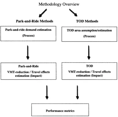
This chapter presents a basic two-part methodology to allow an apples-to-apples comparison of the potential regional travel effects of large-scale transit station parking and transit-oriented development. This methodology was used to estimate the demand for- and travel effects of park-and-ride capacity and transit-oriented development at commuter rail stations, based on a set of local and regional land use, demographic and travel indicators. The first part of the modeling methodology, the process aspect, estimates the amount demand for park-and-ride at a station. The second model component, the effects aspect, estimates the VMT reduction produced by the given level of demand at a particular station, and simulates in parallel the VMT reduction that might be achieved by instead converting station parking to TOD. Figure 2.1 presents the model outline in flowchart form.
One strength of this methodology is its flexibility. This generic method may be used to assess transit station land-use issues in regions and development contexts beyond the Boston case, where it is applied in this study. The generic methodology may also be adapted to a wide range of modeling and forecasting techniques, which may be applied at different stages in the methodology. The approach to the Boston case, presented in Chapter 4, employs fairly unsophisticated modeling techniques, but the basic methodology allows these to be adapted according to the data and modeling expertise available. This chapter lays out the three essential components of this generic methodology, and suggests some of the ways in these may be applied. Chapter 4 then presents one application of the methodology, to eight commuter rail stations in the Boston metro region.
2.1 Process Component: Methodology for Forecasting
Demand for Park-and-Ride
The first component of the methodology is the demand forecasting. Rather than rely on existing data (if there is such data) for the overall number of park-and-ride users, or rate of park-and-ride use among travelers, which may be governed by existing capacity and fail to capture latent demand, this method employs land-use, demographic and travel indicators to estimate an expected demand value for a given station.
Methodology Overview
/
Park-and-Ride Methods TOD Methods
Park-and-ride demand estimation (Process)
Park-and-Ride VMT-reduction / Travel effects
estimation (Impact)
TOD area assumption/estimation
(Process)
TOD
VMT-reduction / Travel effects estimation (Impact)
Performance metrics
Figure 2.1: Methodological Outline
The essential form of the equation used to simulate the demand for park-and-ride (pD) service at a given station is:
pD=W*T*Y
* Where W represents the total population within the catchment area,
* T represents the proportion of that population considered potential park-and-ride users,
* And Y represents the expected park-and-ride mode share among local CBD-bound
commuters.
2.1.1
Station Selection
Selection of station cases may determine the applicability of the one's study results. The generic methodology may be applied to any type of transit station (commuter rail, subway, bus, or multimodal), regardless of whether park-and-ride or TOD are present at the site. A number of factors may be considered in station selection, including geography, transit service type, surrounding land use, demographic and other factors, all of which may have