HAL Id: hal-01765636
https://hal.archives-ouvertes.fr/hal-01765636
Submitted on 13 Apr 2018HAL is a multi-disciplinary open access
archive for the deposit and dissemination of sci-entific research documents, whether they are pub-lished or not. The documents may come from teaching and research institutions in France or abroad, or from public or private research centers.
L’archive ouverte pluridisciplinaire HAL, est destinée au dépôt et à la diffusion de documents scientifiques de niveau recherche, publiés ou non, émanant des établissements d’enseignement et de recherche français ou étrangers, des laboratoires publics ou privés.
Mediterranean and Black Seas: the potential roles of
fluvial sediment starvation and other factors
Manon Besset, Edward J. Anthony, Francois Sabatier
To cite this version:
Manon Besset, Edward J. Anthony, Francois Sabatier. River delta shoreline reworking and erosion in the Mediterranean and Black Seas: the potential roles of fluvial sediment starvation and other factors. Elementa: Science of the Anthropocene, University of California Press, 2017, 5, �10.1525/el-ementa.139�. �hal-01765636�
Introduction
The Mediterranean basin (including the Black Sea) is characterized by a plethora of deltas that have formed as a result of favourable catchment, hydrodynamic and cli-mate conditions, and human-induced changes (Vita-Finzi, 1975; Maselli and Tricardi, 2013; Anthony et al., 2014). The marine hydrodynamic context of Mediterranean river mouths has been largely conditioned by waves, and the alongshore supply of fluvial sediment has been fundamen-tal to the geomorphic development of open-coast beach, dune and barrier systems in situations where coastal mor-phology and wave fetch conditions favour unimpeded longshore drift. Apart from the eastern seaboard of Tunisia and the Adriatic Sea, the Mediterranean continental shelf
is relatively narrow (a few km to about 50 km), and this has favoured weak tides (microtidal regime: mean spring tidal range of 0.5 to 1 m). The wave climate is dominated by short-fetch wind waves (periods of 4–6s), sometimes intermixed with longer waves (8–9s) where fetch condi-tions are more favourable. Wave approach direccondi-tions are very variable. Storms can attain extreme intensities (Lionello et al., 2006), despite the limited fetch. Shaw et al. (2008) have reported destructive historical and pre-historical tsunamis.
Mediterranean deltas range from a few km2 in area, associated with small catchments (tens to hundreds of km2), to major protuberances at the mouths of the larger rivers, the most important of which are the Danube, the Po, the Nile, the Ebro and the Rhône (Figure 1). Several of these large open-coast deltas, notably the Danube and the Rhône, started their development as bay-head deltas in embayments and rias. Numerous smaller deltas, especially in the Central and Western
RESEARCH ARTICLE
River delta shoreline reworking and erosion in the
Mediterranean and Black Seas: the potential roles of
fluvial sediment starvation and other factors
Manon Besset
*, Edward J. Anthony
*and François Sabatier
*The Mediterranean basin (including the Black Sea) is characterized by a plethora of deltas that have developed in a wave-influenced setting. Many of these deltas are sourced in sediments by river catchments that have been variably dammed. The vulnerability status of a selection of ten deltas subject to different levels of reduction in fluvial sediment supply following damming was analysed by quantifying changes in delta protrusion area and protrusion angle over the last 30 years. The rationale for choosing these two metrics, which do not require tricky calculations of longshore bedload transport volumes and river ‘influence’, is that as sediment supply wanes, increasing relative efficiency of waves leads to longshore redistribution of reworked sediments and progressive ‘flattening’ of the delta protrusion. The results show that eight of the ten deltas (Nile, Rhône, Ebro, Ceyhan, Arno, Ombrone, Moulouya, Medjerda) are in erosion, whereas two (Danube, Po) show stability, but the statistical relationship between change in delta protrusion area and sediment flux reduction is poor, thus suggesting that the role of dams in causing delta shoreline erosion may have been over-estimated. But this poor relationship could also be due to a long temporal lag between dam construction and bedload removal and transport to the coast downstream of dams, and, where the delta protrusion is being eroded, to bedload trapping by shoreline engineering structures and by elongating delta-flank spits. Other potential influential factors in shoreline change include subsidence, sea-level rise, storminess, exceptional river floods, and managed sediment releases downstream of dams. A longer observation period and high-resolution sediment-budget studies will be necessary to determine more definitively to which extent continued trapping of sediment behind dams will impact overall delta stability in the Mediterranean and Black Seas. Mitigation of delta erosion is likely to become costlier under continued sediment starvation and sea-level rise.
Keywords: river deltas; delta vulnerability; delta erosion; delta subsidence; river dams; Mediterranean Sea; Black Sea
* Aix-Marseille Univ., CNRS, IRD, CEREGE UM34, 13545 Aix en Provence, FR
Mediterranean, also developed in these embayed set-tings under conditions of high fluvial sediment supply, notably rich in sand and gravel, and locally impeded longshore drift between bedrock headlands (Anthony et al., 2014).
The history and development of deltas in the Mediterranean basin, one of the cradles of civiliza-tion, has been strongly intertwined with the rise and demise of cultures and societies, as well as with major cultural and economic changes, especially over the last Figure 1: Map showing most of the Mediterranean and Black Sea river deltas (a) and Google Earth images of the ten deltas (b). Deltas selected for this study are represented by red dots in (a). The common deltaic plain of the Ceyhan and Seyhan deltas is referred to as the Ceyhan in this paper. Circles in (b) show arbitrarily delim-ited area around the delta mouths (see Materials and Methods). Arrows show wave-induced longshore transport directions: Danube-Stânfu Gheorghe (Vespremean-Stroe and Proteasea, 2015), Nile (Morhange et al., 2005; Ubeid, 2011; Ghoneim et al., 2015), Po (Simeoni et al., 2007; Simeoni and Corbau, 2009), Rhône (Sabatier et al., 2009) Ebro (Jimenez et al., 1997), Medjerda (Amrouni et al., 2014), Moulouya (Dakki, 2003), Arno (Anfuso et al., 2011), Ombrone (Pranzini, 2001). Directions for the Ceyhan are derived from delta plan-shape morphology in relation to the dominant local wave direction. DOI: https://doi.org/10.1525/elementa.139.f1
two millennia (Anthony et al., 2014). The 23 countries bordering the Mediterranean have a total population of 498 million in 2015 (World Population Prospects, United Nations, 2015), with a relatively high density of 96 inhab-itants per km² on the coast (Benoit and Comeau, 2005). Anthropogenic pressures are, therefore, consistently high on the Mediterranean’s coast and deltas. Mediterranean deltas, like many other deltas, commonly have highly pro-ductive soils, rich and biodiverse ecosystems, and offer a wide range of ecosystem services such as coastal defence, drinking water supply, recreation, green tourism, and nature conservation. These deltas are home to millions of people, notably the iconic Nile delta, and host important agricultural and industrial activities as well as transport and communications infrastructure. But, like many del-tas world-wide today, Mediterranean deldel-tas are becoming increasingly vulnerable to catastrophic river floods, sub-sidence, global sea-level rise, and erosion (Anthony et al., 2014).
The vulnerability of modern deltas strongly depends on fluvial sediment supply that is increasingly impacted by human activities, leading notably to accelerated subsid-ence and erosion. Many deltas in the Mediterranean are linked to river catchments that have been dammed over the last few decades. Whereas accelerated subsidence has received a lot of attention in recent years, notably synthesized in the benchmark papers by Ericson et al. (2006) and Syvitski et al. (2009), delta shoreline change, especially erosion, also recognized as an important corol-lary of the diminution of sediment supply to deltas, has been treated in numerous case studies rather than in a synthetic approach.
In this paper, we analyse the current vulnerability status of a selection of ten Mediterranean deltas (Figure 1) by looking at shoreline erosion. The choice of these deltas was based on the following two criteria: a large delta size and/or availability of data. The problem of delta shore-line erosion and the underlying driving mechanisms are examined with reference to quantified variations in delta protrusion area. The ten selected deltas are open-coast deltas more or less exposed to waves and longshore cur-rents that can redistribute, alongshore, reworked deltaic sediments, rather than bay-mouth deltas still encased in wave-sheltered ria-type embayments that have been more or less infilled by coastal aggradation and progradation under conditions of impeded alongshore sediment trans-port. The protrusion area is defined as the area of delta protuberance relative to a straight (theoretically hitherto open-coast) shoreline running across the delta plain and linking the delta to the adjacent protruding non-deltaic shoreline (Figure 2). The rationale for analysing the protrusion area is that as sediment supply wanes, the relative wave and current influence increases, leading progressively to ‘flattening’ of the delta protrusion and shoreline straightening as reworked deltaic sediments are redistributed alongshore (Anthony, 2015). Whereas the fluvial dominance ratio of Nienhuis et al. (2015) pro-vides a prediction of the protrusion angle according to the change in river sediment flux, variation of the protrusion angle can be used to predict a change in protrusion area. Thus, the results could give an indication of the capacity of wave-influenced deltas to maintain their plan-view shape notwithstanding more or less significant sediment reduc-tion. Protrusion reworking can also include the formation
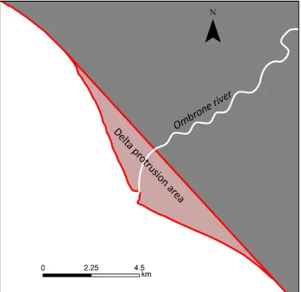
Figure 2: Schematic delimitation of the delta protrusion, using the example of the Ombrone. DOI: https://doi. org/10.1525/elementa.139.f2
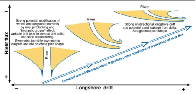
of flanking spits on both active deltas (Anthony, 2015) and abandoned lobes (Nienhuis et al., 2013). Protrusion flattening and the attendant shoreline straightening may involve increasing asymmetry of the delta as part of the trajectory of delta destruction (Figure 3), although asym-metry may be an intrinsic attribute of many prograding deltas, expressed by a more or less skewed delta plan-shape that expresses an uneven distribution of sediment on either side of the central axis of the delta (Bhattacharya and Giosan, 2003; Li et al., 2011; Korus and Fielding, 2015). Anthony (2015) showed that many Mediterranean
deltas presently exhibit a symmetrical or near-symmetrical plan shape that represents mutual adaptation between river flux, delta morphology, and wave approach. Thus, in instances where the deltaic coast at the mouth is indeed asymmetric, this could reflect an imbalance involving strong unidirectional longshore drift, as in the case of the Sfântu Gheorghe lobe of the Danube, characterized by the asymmetric Sacalin barrier (Vespremeanu-Stroe and Preoteasa, 2015). Some of the characteristics of the ten selected deltas, which are also among the largest in the Mediterranean, are shown in Table 1.
Figure 3: Schematic continuum of delta morphology and potential net long-term trajectory of evolution. The morphology ranges from symmetric to strongly longshore-deflected and asymmetric, as a function of river influence relative to wave-induced longshore transport. Delta destruction occurs as river influence becomes weakened by a variety of natural (changes in catchment climate and vegetation linked to the Little Ice Age, for instance, avulsion) and human-induced changes (catchment land-use and reforestation, catchment engineering, dams). From Anthony, 2015. DOI: https://doi.org/10.1525/elementa.139.f3
Table 1: Selection of data on the ten deltas and on their catchments and river discharge. Danube (Coleman and Huh, 2004; Preoteasa et al., 2016), Ebro, Nile and Po (Coleman and Huh, 2004), Arno, Ceyhan (Syvitski and Saito, 2007), Rhône (Provansal et al., 2014), Ombrone (Syvitski et al., 2005), Medjerda (Meybeck and Ragu, 1996), Moulouya (Snoussi et al., 2002; Milliman and Farnsworth, 2011). DOI: https://doi.org/10.1525/elementa.139.t1
Deltas River basin
area (km²) River length (km) Fresh water discharge (m3/s) Sediment discharge (kg/s) Delta area from apex (km²) River mouth
number Protrusion area (km²)
Arno 9200 240 57 72 437 1 6 Ceyhan-Seyhan 34210 380 222 173 150 2 1243 Danube 779500 2536 6499 630 5560 3 2302 Ebro 85100 624 240 34 935 1 304 Medjerda 15930 370 18 297 209 2 16 Moulouya 51000 520 21 151 787 1 2 Nile 3038100 3878 2778 3876 12512 2 1366 Ombrone 3480 130 32 60 37 1 19 Po 87100 691 1514 561 948 1 512 Rhone 90000 820 1700 167.54 3194 2 523
Materials and methods
The methodological approach involved three types of complementary analyses: (a) variations in delta protrusion area, (b) changes in delta protrusion angles, and (c) the degree of spit development in deltas where one or more spits are present, as an indicator of shoreline change.
(a) Delta protrusion area
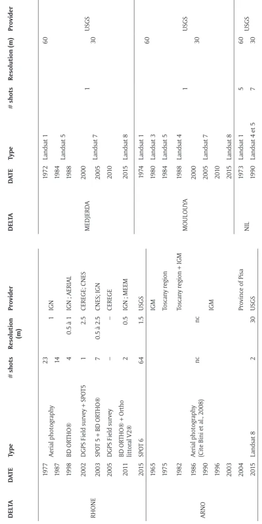
In order to highlight recent deltaic shoreline changes and variations in delta protrusion area, we selected available satellite images of high (pixel size: 1.5 to 2.5 m) to moder-ate (pixel size: 30 to 60 m) resolution made available by the USGS and the French IGN, as well as aerial orthopho-tographs and, for the Rhône, field data (Table 2). The spa-tial data were chosen to cover the entire ‘delta-influenced’ shoreline for each year of analysis and with a cloud cover not exceeding 10%. We limited our choice to images taken at low tide and systematically in January of every year to minimize seasonal and tidal distortions (tides induce very little variability in the microtidal context of the Mediter-ranean and Black Seas). For each delta, the change in pro-trusion area between 1985 and 2015 was determined. The deltas were classed in terms of net area loss, net area gain, and stability. The shoreline was identified as the exter-nal limit, when observable, of vegetation between land and sea. Whenever the use of the vegetation marker was not feasible, we identified a variety of lasting indicators such as engineering structures to delimit the shoreline. Although the satellite data resolution varies, we chose to attribute a common error margin, incremented for del-tas with moderate-resolution data. The error margin of the protrusion area for each delta was calculated from the errors due to satellite image resolution and operator uncertainty in manually delimiting the shoreline, given by the following equation:
* l
L E E
S
= (1)
where E is the error margin (in km), L the total shoreline length (in km), El the error relative to the resolution of the satellite images and operator uncertainty (in km), and S the protrusion area (km²). The result was then multi-plied by the 30-year period of delta protrusion shoreline change. The area differentials have a mean error margin of 0.0092 km²/yr. El is expressed by a value increment of two pixels per km: one pixel to compensate for shades of colour of the satellite images and the other for operator errors in delimiting the shoreline, i.e., 0.018 km² per km.
The overall area differentials of the deltas are, with regards to the error margins, significant for all the deltas when expressed against delta protrusion area. We calcu-lated the relative percentage error of change in protrusion area using the following equation:
% 100 * * L E E S = (2)
where E% is the percentage error of change in protrusion area.
E% ranged from ±5.4% for the Moulouya delta to ± 0.1% for the Ceyhan and Danube deltas. Deltas exhibiting gains or losses of less than the computed value were consid-ered as stable, with negligible evolution over the 30-year period.
In complement to the overall delta shoreline change, the area change affecting the vicinity of the mouth(s) of each delta was also calculated using arbitrary limits depicted in Figure 1b. The reason for this operation is that the mouth zone is the primary receptacle of bedload exiting from the river, such that significant changes in this zone may be a good indicator of changes in fluvial bed-load supply and/or in the intensity of reworking by waves and currents.
(b) Changes in delta protrusion angles
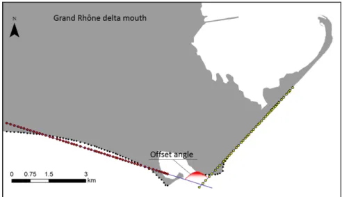
We used as a marker of shoreline change the variation in the mean angle of the protrusion shoreline on either side of the mouth of the delta. In wave-influenced deltas com-monly characterized by a cuspate protrusion morphology, the mouth is, theoretically, the zone most exposed to inci-dent waves, although, in the presence of sustained sedi-ment inputs, this zone is also subject to sedisedi-mentation and formation of mouth bars that dissipate wave energy. The larger the angle of the shoreline relative to the mouth, the ‘flatter’ the delta protrusion, and the straighter the shoreline subjected to alongshore redistribution of flu-vial and reworked delta sediment on either side of the mouth. The mean angle was measured from linear regres-sion lines of points at a regular interval of either 80 m (for images of 1970s) or 30 m (for 2015) along the shoreline on either side of the delta mouth at two dates (Figure 4). This analysis was carried out for all deltas for the year 2015 and the angle variation calculated relative to the year for which the earliest images, starting from the 1970s, were available: 1972 for the Ombrone and Ebro deltas, 1973 for the Ceyhan and the Nile, 1974 for the Moulouya, 1975 for the Po and Arno, 1977 for the Rhône and 1978 for the Danube. We postulated that an increase in this angle from one date to the other signified that the delta protru-sion had become relatively flatter and more influenced by incident waves and longshore currents that redistribute reworked sediments away from the confines of the mouth, and potentially beyond the deltaic shoreline.
To estimate the error margins related to the measured offset river mouth angles (Ө), we computed the errors associated with satellite image resolution and opera-tor measurements (Figure 4). The theoretical shoreline on either side of the mouth was produced from a linear regression of points along the shoreline at the regu-lar intervals defined above. The distances between the coordinates of each point and its projection in the linear regression yielded negative or positive residuals (Ry) (in km) relative to the regression line (Figure 5). The absolute value of each residual was extracted and considered as the distance from the regression of each point. The arithmetic average of the residuals was calculated for the shoreline on each side of the mouth. These values were summed up with those of El. The result therefore corresponded to the error envelope of shoreline delimitation (Figure 5).
Table 2:
Satellite and aerial photograph data used in the statistical analysis of deltaic shoreline change. DOI:
https://doi.org/1 0. 1525/elementa. 139.t2 DEL TA D AT E Type # shots Resolution (m) Provider DEL TA D AT E Type # shots Resolution (m) Provider RHONE 1977 Aerial photography 23 1 IGN MEDJERD A 1972 Landsat 1 1 60 USGS 1987 14 1984 Landsat 5 30 1998 BD OR THO® 4 0.5 à 1 IGN ; AERIAL 1988 2002 DGPS Field sur vey + SPO T5 1 2.5 CEREGE; CNES 2000 Landsat 7 2003 SPO T 5 + BD OR THO® 7 0.5 à 2.5 CNES; IGN 2005 2005 DGPS Field sur vey – – CEREGE 2010 2011 BD OR THO® + Ortho littoral V2® 2 0.5 IGN ; MEEM 2015 Landsat 8 2015 SPO T 6 64 1. 5 USGS MOULOUY A 19 74 Landsat 1 1 60 USGS ARNO 1965
Aerial photography (Cite Bini et al., 2008)
nc nc IGM 1980 Landsat 3 1975 Toscany region 1984 Landsat 5 30 1982
Toscany region + IGM
1988 Landsat 4 1986 IGM 2000 Landsat 7 1990 2005 1996 2010 2003 2015 Landsat 8 2004 Province of Pisa NIL 1973 Landsat 1 5 60 USGS 2015 Landsat 8 2 30 USGS 1990 Landsat 4 et 5 7 30 (contd.)
EBR O 1985 Landsat 5 1 30 USGS 2005 Landsat 7 5 1990 Landsat 4 2015 Landsat 8 4 2000 Landsat 7 OMBR ONE 1972 Landsat 1 3 60 USGS 2004 1985 Landsat 5 1 30 2010 1990 Landsat 4 2014 Landsat 8 2000 Landsat 7 CEYHAN 1973 Landsat 1 2 60 USGS 2005 1984 Landsat 5 30 2010 2000 Landsat 7 2015 Landsat 8 2015 Landsat 8 PO 1975 Landsat 2 1 60 D ANUBE 1978 Landsat 3 2 60 USGS 1985 Landsat 5 5 30 USGS 1989 Landsat 4 30 2000 Landsat 7 1 1995 Landsat 5 2010 2000 Landsat 7 2015 Landsat 8 2005 2010 4 2015 Landsat 8 1
In calculating the error margin of Ө, the down-mouth end of each shoreline Sh was offset by the angular dis-tance Dt(left or right)/2, expressed by:
t y l
D =R +E (3)
By subtracting the measured value of Ө’ from Ө, as shown in Figure 5, we obtained the average error margin of the angle for each delta.
(c) Spit growth
For deltas characterized by one or more spits, spit length-ening over the 30-year period has been used as a geometric marker of shoreline change. The speed of spit lengthening has been calculated for each delta up to the year 2015. Results
The results show that eight out of the ten studied deltas in the Mediterranean and Black Seas have lost protrusion area over the last 30 years, with a maximum, respectively,
of 34.4% and 16.3% for the Moulouya and Medjerda del-tas in North Africa (Figure 6). However, changes are rela-tively weak in the other deltas (Figure 6). Although the Danube shows a large apparent gain in area compared to the other deltas, this gain is insignificant when com-pared to the protrusion area of the delta, of the order of 2,300 km², i.e., 0.1% in 30 years, equivalent to the error margin. This is also the case of the Po delta, one of the three largest deltas in the Mediterranean, the area gain of which has been negligible over the last 30 years. These results are coherent with trends reported in the literature for several deltas (Table 3). A close scrutiny of the data shows that much of the area loss has occurred in the vicin-ity of the river mouths (Figure 7). Only the mouths of the Arno, the Sulina and the Chilia show area gain.
In terms of temporal trends in shoreline change, most of the deltas show fluctuations over the 30-year period (Figure 8), with the Danube being the only delta with a clearly affirmed recent (since 2008) upswing in protru-sion area gain. The Nile delta shows a long-term trend of Figure 4: Method of quantification of the shoreline protrusion on either side of the delta mouth. The
protru-sion is delimited by the red arc with the example of the Grand Rhône mouth (Rhône). Black dots show shoreline delimitation points every 30 m (for images of the 1970s) or 80 m (for images of 2015), purple lines the regression lines of the generated linear model, and red and yellow dots the projection of points indicating shoreline position on the linear regression line, respectively on either side of the mouth. DOI: https://doi.org/10.1525/elementa.139.f4
Figure 5: Method for calculating error margins of the offset river mouth angles. DOI: https://doi.org/10.1525/ elementa.139.f5
Table 3: Published references on delta shoreline change for the Arno, the Ombrone, the Rhône, the Nile, the Moulouya, the Medjerda and the Ebro deltas. DOI: https://doi.org/10.1525/elementa.139.t3
Delta Reference for comparison Comparison Period Arno Bini et al., 2008 Surface area change 1965–2004 Ombrone Cipriani et al., 2013 Metric area change 1973–2005/2006 Rhône Sabatier and Suanez, 2003 Metric area change 1987–2000/2002 Nile Torab and Azab, 2006 Surface area change (between
Rosetta and Damieta mouths) 1973–2001/2005 Moulouya Mouzouri et al., 2011 Observations 1988–2006 Medjerda Louati et al., 2014 Metric area change 1987–2000/2002 Ebro Jimenez et al., 1997; Jimenez and
Sanchez-Arcilla, 1993
Metric area change and trends 1985–1990
Figure 6: Statistical analysis of rates of shoreline area change. Rates of area change along the shorelines of the ten deltas (top graph). Percentage of delta protrusion area change for each delta over 30 years (bottom graph). Negative values (red columns) represent delta protrusions subject to erosion, and positive values (blue columns) prograding delta protrusions. DOI: https://doi.org/10.1525/elementa.139.f6
erosion in the wake of the construction of the Aswan High Dam in 1964 that attained a peak in 1990, with erosion waning and replaced by relative stability over the last dec-ade. The Po, Ceyhan and Ombrone deltas show a decline in area gain, and even a shift towards increasing loss over the last few years. Area losses have increased over the last 15 years for the Ombrone, Po, Rhône, Medjerda, Ceyhan, and Ebro deltas.
Regarding protrusion angles of the deltas, 9 delta mouths exhibit an increase in angle from the 1970s to 2015, with a maximum change for the abandoned mouth of the Medjerda, after a diversion canal built in 1939 resulted in flow division. The initial river mouth became abandoned (Figure 7) in March 1973 after an exceptional flood (Guen, 1988). The mouths of the Arno, Po, Rhône, and the Sfântu Gheorghe mouth of the Danube show a slight decrease or negligible increase not exceeding their respective error margin values over the study period. With the exception of the Arno, all of these delta mouths are also characterized
by wave-constructed spits. The results show extensions of the spits, already extant in the 1970s, flanking the mouths of the Ebro, Po, Rhône, Danube (Sfântu Gheorghe) and Nile (Damietta) deltas, ranging from 7 m/year to more than 160 m/year (Figure 10). The comparison between the evolution of the protrusion angle at the mouth and the change in lengths of these spits shows that the absence of coastal flattening, for the majority of the deltas, is com-pensated by important spit elongation. The Damietta protrusion of the Nile is an exception characterized by a progressive increase in shoreline angle together with spit lengthening of 3.15 km between 1990 and 2015.
Discussion
The impacts of human activities on Mediterranean river catchments and sediment flux have been documented in several case studies and in basin-scale syntheses (e.g. Bravard, 2002; Poulos and Collins, 2002; Hooke, 2006; Milliman and Farnsworth, 2011). Engineering works aimed Figure 7: Surface area change in the immediate vicinity of the delta mouths. Area change, in m²/year, corre-sponds to the circled area. Losses are depicted in red and gains in blue. Note that the Medjerda underwent a major avulsion in 1973 following an important flood, leading to a new mouth in the south and abandonment of the histori-cal mouth in the north. DOI: https://doi.org/10.1525/elementa.139.f7
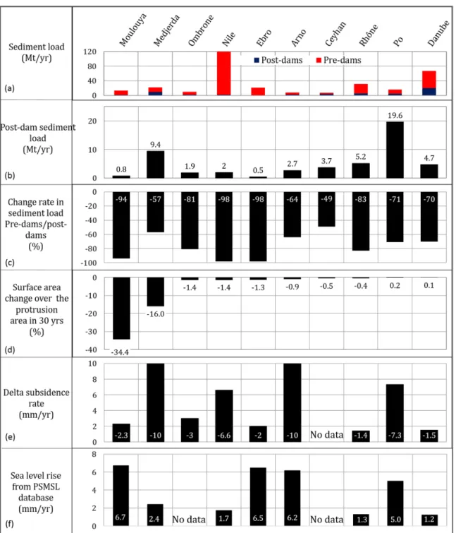
at torrent management and channel embanking to assure flood control and navigation, as well as in-channel gravel and sand extractions, have significantly affected fluvial sediment supply to the coast. Over the last fifty years, dams intercepting and storing much of the fluvial sediment flux appear to stand out, however, as the dominant cause of reduction of river sediment to coastal sinks (e.g. Surian and Rinaldi, 2003). Hundreds of dams constructed across rivers draining into the Mediterranean Sea are deemed to have generated significant reductions in fluvial sediment loads, and none of the river catchments feeding the ten deltas selected for this study has been spared. Eight of the ten deltas are associated with catchments that have lost more than 60% of their sediment flux (Figure 12a, b, c). The Ombrone, Rhône, Ebro, Moulouya and Nile deltas have lost more than 80% of their fluvial loads following the construction of dams, this figure attaining 98% in the iconic case of the Nile. The sediment load of the Danube is still relatively high at 19.9 Mt/yr, despite a 70% drop after the construction of dams. The Ceyhan catchment, the latest to be affected by dams, has also lost a significant amount of its fluvial sediment flux, although this loss has
been much less severe than in several other catchments such as the Arno, Ombrone, Ebro, Moulouya and Nile, that now supply less sediment to their deltas than the Ceyhan. Although the relationship between dams and river sedi-ment flux reduction appears, as expected, to be the over-arching element of river catchment management in the Mediterranean and Black Seas in recent decades, there is a spatial and temporal variability in this relationship that implies that other factors need to be taken into account (Anthony et al., 2014). Land-use changes in Mediterranean catchments, especially the abandonment of farmland in the mountainous hinterlands, have led to reforestation, and concomitant reductions in fluvial sediment yields.
Although eight out of the ten deltas show both an erosional tendency and important decrease in fluvial sediment load, the statistical relationship between these two variables is not significant (Figure 11). This relation-ship is, in fact, only strongly expressed for the Moulouya and Medjerda deltas, which have significantly retreated over the study period. All the other deltas show very lit-tle loss or relatively mild gain (cases of the Danube and Po), notwithstanding significant decreases in fluvial Figure 8: Temporal evolution of shoreline area change for each delta over 30 years. DOI: https://doi.org/10.1525/
Figure 9: Changes in angles of delta protrusion between the 1970s and 2015. A decrease in protrusion, cor-responding to delta shoreline straightening, is denoted by higher 2015 angles. DOI: https://doi.org/10.1525/ele-menta.139.f9
Figure 10: Rates of elongation of spits flanking the Ebro, Danube, Rhône, Nile and Po deltas. Blue shoreline indicates accretion and red erosion. DOI: https://doi.org/10.1525/elementa.139.f10
sediment flux, notably in the Nile, Ebro, Arno and Rhône deltas (Figure 12d). The poor relationship could suggest that: (1) the negative effect of dams on sediment supply decrease to deltas in the Mediterranean is presently over-estimated, (2) the relative shoreline stability reflects a lag in the downstream propagation of the effect of dams on the reduction of bedload transfer from river channels to delta shorelines. Liquete et al. (2005) noted that sediment load reduction effects have, to date, had, little effect on many of the deltas of the small, steep rivers and torrents of the coast of Andalusia. Elsewhere, deltas have actually accreted as a result of land-use changes, a fine example being the Meric in Turkey (Ekercin, 2007). Although the Ceyhan delta shows a net loss of area, much of this loss is attributed to significant retreat of its twin Seyhan lobe following dam construction (Alphan, 2005). The first major dam on the Seyhan was constructed only in 1984 (Ataol, 2015), and since then, nine other dams have been constructed between 1989 and 2013. The less-dammed Ceyhan has shown net delta area gain following deforesta-tion (Kuleli, 2010).
Although dams are incriminated as the primary cause of modern fluvial sediment retention, with the consequent negative feedback effects on coastal sediment budgets and shoreline erosion in the Mediterranean, very few studies have actually attempted to disentangle decreases in sedi-ment flux caused by natural and land-use changes from those generated by dams (Anthony et al., 2014), a fine exception being that of the well-documented Rhône River budget over the last 130 years published by Provansal et al. (2014). These authors concluded that dams constructed on the river over the last thirty years have had little or no impact, the river having already been transformed by navigation and flood control works before upstream dam
installations could impact the downstream reach and the coast. The sources of sediment, torrential in origin, had already been exhausted before the dams were constructed. In their review of research progress and future directions in the relationship between dams and geomorphology, Petts and Gurnell (2005) showed that river relaxation downstream of dams can occur over very long periods of time, except for semi-arid systems, where changes can be initially rapid. This observation is in agreement with the significant erosion that has affected the Moulouya and Medjerda deltas over the 30-year period of study follow-ing dammfollow-ing of these two rivers. Only the Danube delta shows net advance over the 30-year period, notwithstand-ing a drop in fluvial sediment supply. Whereas the sedi-ment load has decreased significantly (70%), the liquid discharge exiting at the mouths of the Danube has hardly varied, and this could be a significant factor in the relation-ship between river flux and its ‘hydraulic-groyne effect’ in mitigating wave reworking and evacuation of river-mouth deposits away from the delta confines (Anthony, 2015). Another factor could be the long relaxation time of the large Danube catchment after construction of the Iron Gate dams, with a bedload supply, from downstream of the last dams, to the coast at still practically pre-dam val-ues, but this is an unresolved issue. A longer observation period, and high-precision river sediment-budget studies, of the type carried out by Provansal et al. (2014) on the Rhône, will be necessary to determine more definitively to which extent continued sediment trapping behind dams will impact delta shoreline change and overall delta stabil-ity in the Mediterranean and Black Seas.
Since our shoreline analysis covers the delta protru-sion area, and assuming that reductions in sediment flux have affected delta shoreline sediment budgets, the poor Figure 11: Scatter plot of delta protrusion area change rate versus loss of sediment after dam construction.
Figure 12: Graphs depicting changing river sediment loads and delta-plain subsidence confronted with changes in delta protrusion area for the ten deltas. (a) Pre- and post-dam sediment loads in Mt/year for the Arno River (Billi and Rinaldi, 1997), the Medjerda River (Sliti, 1990; Rand McNally Encyclopedia of World Rivers, 1980; Meybeck and Ragu, 1996; Tiveront, 1960; Milliman and Farnsworth, 2011), the Ebro River (Palanque et al., 1990; Vericat and Batalla, 2006), the Po River (Idroser, 1994 cited in Simeoni and Corbau, 2009; Syvitski and Kettner, 2007), the Ceyhan River (EIE, 1993, cited by Cetin et al., 1999), the Rhône River (Milliman and Meade, 1983; Ollivier et al., 2010; Dumas et al., 2015; OSR, 2016), the Moulouya River (Snoussi et al., 2002), the Ombrone River (Milliman and Farnsworth, 2011), the Nile River (Syvitski and Saito, 2007; Milliman and Farnsworth, 2011), and the Danube River (Milliman and Farnsworth, 2011; Preoteasa et al., 2016); (b) Post-dam sediment loads in Mt/year (note difference in scale between (a) and (b); (c) Percentage change in fluvial sediment loads following dam construction; (d) Percentage change in surface protrusion area over 30 years; (e) Mean delta-plain subsidence rates in mm/year: Arno (CNR, 1986), Danube (Vespremeanu et al., 2004), Moulouya (Church et al., 2004), Nile (Becker and Sultan 2009; Marriner et al., 2012; Stanley and Clemente, 2017), Po (Bondesan et al., 1995), Rhône (Vella and Provansal, 2000), Ebro (Ibáñez et al., 1997), Ombrone (Pranzini, 1994), Medjerda (World Bank, 2011; Louati et al., 2014). Note that sediment loads in the European rivers have also undergone reductions related to catchment reforestation during both the pre-dam and the recent to present post-dam periods, as shown by the budget calculations of Provansal et al. (2014) for the Rhône. DOI: https://doi.org/10.1525/elementa.139.f12
relationship between shoreline area change and river sedi-ment flux could also be explained by spatial and temporal variations in shoreline dynamics. Although the immedi-ate vicinity of the river mouths is potentially the primary receptor of fluvial sediment, virtually all of the deltas showed a loss of area at their mouths (Figure 7). There is a probability that bedload losses that could arise from wave reworking of the delta protrusions, especially at the mouths, are mitigated by: (1) intrinsic sediment seques-tering alongshore, within the confines of the deltas, (2) delta shoreline stabilization structures, and/or (3) delta spit lengthening. Intrinsic sediment sequestering along-shore could be a along-shoreline self-stabilization mechanism that counters sediment loss from the confines of the delta, especially in settings, such as the Mediterranean and Black Seas, where the influence of waves and wave-generated currents is important in delta shoreline reworking (Anthony, 2015). The old classification proposed by Fisher et al. (1969) distinguished, from a stratigraphic point of view, between ‘highly constructional’ river deltas in set-tings of strong fluvial influence and weak wave and cur-rent activity, and ‘highly destructional’ deltas which occur where wave reworking removes a significant part of the fluvial load. More recently, Nienhuis et al. (2013) numeri-cally explored modes of wave reworking of abandoned delta lobes via longshore transport, while Anthony (2015) showed the potential for some wave-influenced deltas to sequester reworked shoreline sand through self-organized behaviour involving changing gradients in longshore sedi-ment transport and notably counter-longshore drift pat-terns at the confines of the deltas. Nienhuis et al. (2015) further proposed a ‘fluvial dominance ratio’ expressed by river sediment input versus the potential maximum along-shore sediment transport away from the delta mouth to quantify the balance between river inputs and what they rightly considered as the largely overlooked ability of waves to spread sediments along the coast.
The longshore transport patterns of the ten deltas, culled from the literature, with the exception of the Ceyhan, are summarized in Figure 1. The dynamics of these delta mouths highlight both ‘open’ unidirectional longshore transport of bedload, and bi-directional trans-port from the mouths. The cases of the Arno, the Sulina and the Chilia seem to correspond to situations where sediment blocking at the mouth has been favoured. The Chilia is currently the main mouth of the Danube, captur-ing about 58% of the liquid and sediment discharge of the entire Danube basin (Bondar and Panin, 2001; Tatui and Vespremeanu-Stroe et al., 2016). The mouth of the Arno has been strongly engineered, and this results in bedload trapping in its vicinity (Anfuso et al., 2011).
The protrusion angles and their variations in time shown in Figure 9 may be used to gauge the impact of wave reworking in a context of decreasing water and sedi-ment discharge. Nine delta mouths (for a total of 6 deltas) exhibit an increase in angle from the 1970s to 2015 that is tantamount to a general flattening tendency of their pro-trusion, and alongshore leakage of reworked mouth sedi-ments, among which the Moulouya exhibits the highest
change in angle. Where this angle change has been mini-mal, shoreline change is probably compensated by both spit lengthening, as in the cases of the Sfântu Gheorghe, Ebro, Po and Grand Rhône (Figure 9), and engineering structures designed to trap bedload. In the former situ-ation, bedload exiting from the mouths is transported along the spits by waves. This mechanism assures wave energy dissipation through spit elongation. The role of shoreline engineering is further evoked below.
The results also show variability in shoreline change trends. The Nile, Moulouya and Arno deltas tend to show decreasing erosion, whereas the Po, Rhone, Ebro, Medjerda, Ceyhan and Ombrone deltas show a pro-nounced downswing with increasing erosion (Figure 8). Given the poor relationship between delta shoreline ero-sion and post-dam sediment reduction (Figure 11), the pattern in the former group may be due to a large range of factors. Engineering works along the Nile (Ghoneim et al., 2015; Ali and El-Magd, 2016) and the Arno delta shorelines (Anfuso et al., 2011) may explain the reduction trend, but such engineered mitigation of delta shoreline erosion is likely to become costlier in the face of sea-level rise and continued sediment starvation. In the case of the Moulouya, strong erosion at the mouth (Figure 7) and increasing flattening of the delta protrusion by wave and current reworking (Figure 9) may be leading to shoreline straightening and decreasing alongshore transport rates that also imply lesser erosion. Imassi and Snoussi (2003) calculated an area loss at the mouth of the Moulouya delta of 800,000 m² between 1958 and 1986, following commissioning of the first dams, the largest of which was constructed in 1967, and which led to a reduction in water and sediment discharge of up to 94% (Snoussi et al., 2002). The mean area loss rate calculated in our study over the period 1986 to 2015 corresponds to less than 20% of the mean annual net loss calculated by Imassi and Snoussi (2003), in agreement with a slow-down in along-shore bedload transport along an increasingly straight-ened shoreline.
The pattern in the latter group (Po, Rhone, Ebro, Medjerda, Ceyhan and Ombrone deltas) may be readily linked to the substantial recent decreases in fluvial sedi-ment, notwithstanding the poor statistical relationship between shoreline change and fluvial sediment supply. Fluctuations in this trend, with temporary accretion pulses (Figure 8), may be related to exceptional sediment-supply conditions associated with larger river floods and/or engineered sediment releases from dams. This seems to be the case of the two small peaks evinced by the Rhône delta between 2000 and 2005, and between 2011 and 2015. The 2000–2005 peak no doubt corresponds to the effect, on sediment supply, of both engineered sediment releases from reservoirs on the Rhône, to the tune of 1.7 Mt by the firms running the dams, and a 1000-year return flood in December 2003. The 2011–2015 peak could be due to sediment releases from dams in 2012 of the same volume as in 2003. Maillet et al. (2006) calculated from bathymetric differencing a total of 600,000 m3 of sedi-ment transferred from the Rhône catchsedi-ment to the delta
and its inner nearshore zone following the December 2003 flood.
In other cases, phases of lower wave reworking asso-ciated with decreased ‘storminess’ may also have influ-enced the temporal pattern. Zainescu et al. (2017) have highlighted an unprecedented level of low storminess off the Danube delta since 2006 that has been matched by more fluvial deposition at the delta mouths and reduced wave reworking. Regarding the wave climate, however, analysis of ERA-40 and ERA-Interim hindcast data in the Mediterranean Sea generated by the Wave Atmospheric Model (WAM) model of the ECMWF (European Centre for Medium-Range Weather Forecasts) does not show any sig-nificant trend in wave height over the 30-year period of study of delta shoreline change.
Two final points of discussion concern the vulnerabil-ity of the deltas to subsidence and sea-level rise. Whereas some deltas such as the Nile and the Medjerda are affected by high subsidence rates, others, such as the Moulouya and Ebro, are more heavily impacted by sea-level rise (Figure 12e, f). Still others are exposed to both subsidence and rising sea level, as in the cases of the Po and the Arno. Deltas with the largest protrusion losses are not those cur-rently exhibiting the highest subsidence rates, as shown by the Moulouya, probably a dominantly bedload delta, given its low subsidence rate of 2 mm/year (Figure 12e). In fact, there is no clear relationship between the 30-year loss in protrusion area and current subsidence rates. Compensation for subsidence no doubt takes up some of the still subsisting fluvial sediment supply to the del-tas, especially the fine-grained over-bank sediment. The Medjerda probably illustrates the moderating effect of a still relatively sustained sediment supply following dam construction on a high subsidence rate of 10 mm/year. The Po exhibits a moderately high subsidence rate of more than 7 mm/year (Figure 12e), and shows only neg-ligible shoreline change with regards to the large size of its protrusion (Figure 6b). This situation may be due to a combination of three factors: (1) the relatively low drop in fluvial sediment supply, compared to other del-tas (Figure 12a, c, d), (2) the relatively wave-sheltered setting of this delta (Figure 1), and (3) changes in delta-plain depocentres associated with a net deceleration in human-induced subsidence. Subsidence from accelerated compaction generated by methane production in the Po delta from the late 1930s to the 1970s reached rates of 60 mm/year (Caputo et al. 1970, in Syvitski, 2008), but decreased by a factor of five after methane production ceased, and subsidence shifted to where sedimentation was more active (Bondesan and Simeoni, 1983, in Syvitski, 2008). Acceleration of subsidence and sea level rise in Mediterranean and Black Seas could lead to increasing delta vulnerability to erosion, as compensation of surface sinking and infill of accommodation space created by sea-level rise may not be sufficient under the currently pre-vailing sediment-supply conditions.
Conclusions
1. Delta protrusion area, defined as the area of delta protuberance relative to a straight shoreline running across the delta plain, and linking the
delta to the adjacent non-protruding non-deltaic shoreline, appears to be a useful criterion for analyzing river delta vulnerability to wave activity in the strongly wave-influenced setting of the Mediterranean.
2. Analysis of protrusion area loss for ten
Mediterranean and Black Sea deltas show that eight are in erosion and two show negligible relative gain in protrusion area.
3. With the exception of the Moulouya and Medjerda deltas, the sediment loads of which are probably impacted by their semi-arid setting in addition to trapping behind dam reservoirs, the protrusion area loss has been moderate.
4. There is no statistically significant relationship between change in delta protrusion area and drop in river sediment supply following the construction of dams.
5. This poor relationship is probably due to: (a) over-estimation of the effect of dams on sediment supply decrease to deltas in the Mediterranean, and (b) a lag in the downstream propagation of the effect of dams on the reduction of bedload transfer from river channels to delta shorelines, with the exception of the Moulouya and Medjerda deltas, the semi-arid catchments of which appear to have responded rapidly to damming.
6. This poor relationship could also reflect the possibility that bedload losses that could arise from wave reworking of delta protrusions are: (a) mitigated by sequestering alongshore, within the confines of the deltas, (b) mitigated by delta shoreline stabilization structures, and/or (c) compensated by delta spit lengthening. 7. A longer observation period and high-precision
river sediment-budget studies will be necessary to determine to which extent continued sediment trapping behind dams will eventually impact, in a more definitive way, delta shoreline change and overall delta stability in the Mediterranean and Black Seas.
8. Fluctuations in shoreline protrusion area over the 30 years involving temporary accretion pulses may be related to exceptional sediment supply conditions associated with larger river floods, phases of lower wave reworking associated with decreased ‘storminess’, or engineered sediment releases from dams.
9. There is no clear relationship between the 30-year loss in protrusion area and current subsidence rates. Data Accessibility Statement
• The World Deltas Database Framework: http://www. geol.lsu.edu/WDD. • Landsat satellite images: https://earthexplorer.usgs. gov/. • Wave climate data: http://apps.ecmwf.int/datasets/ data/era40-daily/levtype=sfc/. • Tide data: http://www.psmsl.org/. • The digitized shorelines and geometric processing can be available by contacting MB (besset@cerege.fr).
Acknowledgements
We acknowledge the use of Landsat satellite images pro-vided by the United States Geological Survey (USGS), Spot satellite images provided by Centre National d’Etudes Spatiales (CNES), ECMWF ERA-40 and ERA-Interim wave datasets provided by the European Centre for Medium-Range Weather Forecasts (ECMWF), and the Permanent Service for Mean Sea Level (PSMSL) for sea level data. We thank Guest Editor Irina Overeem and the two anonymous reviewers for their salient suggestions for improvement of the manuscript.
Funding information
This is a contribution of the Belmont Forum Project ‘BF-Deltas: Catalyzing Action Towards Sustainability of Deltaic Systems with an Integrated Modeling Framework for Risk Assessment’. Manon Besset benefited from a PhD grant provided by Aix-Marseille Université.
Competing interests
The authors have no competing interests to declare. Author contributions • Contributed to conception and design: MB, EJA, FS • Contributed to acquisition of data: MB, EJA, FS • Contributed to analysis and interpretation of data: MB, EJA, FS • Drafted and/or revised the article: MB, EJA, FS • Approved the submitted version for publication: MB, EJA, FS References
Ali, EM and El-Magd, IA 2016 Impact of human inter-ventions and coastal processes along the Nile Delta coast, Egypt during the past twenty-five years. Egyptian J Aquatic Res, 42: 1–10. DOI: https://doi. org/10.1016/j.ejar.2016.01.002
Alphan, H 2005 Perceptions of coastline changes in river deltas: southeast Mediterranean coast of Turkey. International Journal of Environment and
Pollu-tion, 23: 92–102. DOI: https://doi.org/10.1504/
IJEP.2005.006398
Amrouni, O, Hermassi, T, Jaouad, SA and Messaoudi, S 2014 Contribution of Grain-size Trend to Sediment of a Microtidal Beach. Case of the Gulf of Tunis Bay (Cape Ferina-Cape Gammarth, Tunisia). Res J Envi-ron Sci, 8: 161–177. DOI: https://doi.org/10.3923/ rjes.2014.161.177
Anfuso, G, Pranzini, E and Vitale, G 2011 An inte-grated approach to coastal erosion problems in northern Tuscany (Italy): Littoral morphological evolution and cell distribution. Geomorphology, 129: 204–214. DOI: https://doi.org/10.1016/j. geomorph.2011.01.023
Anthony, EJ 2015 Wave influence in the construction, shaping and destruction of river deltas: A review. Mar
Geol, 361: 53–78. DOI: https://doi.org/10.1016/j.
margeo.2014.12.004
Anthony, EJ, Marriner, N and Morhange, C 2014 Human influence and the changing geomorphology of Med-iterranean deltas and coasts over the last 6000 years:
from progradation to destruction phase? Earth-Sci Rev, 139: 336–361. DOI: https://doi.org/10.1016/j. earscirev.2014.10.003
Ataol, M 2015 A crevasse splay induced avulsion on the Ceyhan Delta. J Int Soc Res, 8: 675–681. DOI: https://doi.org/10.17719/jisr.20154115048
Becker, RH and Sultan, M 2009 Land subsidence in the Nile Delta: inferences from radar interferometry.
The Holocene, 19(6): 949–954. DOI: https://doi.
org/10.1177/0959683609336558
Benoit, G and Comeau, A 2005 Méditerranée, les per-spectives du Plan Bleu sur l’environnement et le développement, 431. Aube et Plan Bleu. Ed. diffusion Seuil.
Bhattacharya, JP and Giosan, L 2003 Wave-influenced deltas: geomorphological implications for facies reconstruction. Sedimentology, 50: 187–210. DOI: https://doi.org/10.1046/j.1365-3091.2003.00545.x Billi, P and Rinaldi, M 1997 Human impact on sediment
yield and channel dynamics in the Arno River basin (central Italy). In: Walling, DE and Probst, JL (eds.), Human Impact on Erosion and Sedimentation: Rabat, Marocco, 246: 301–311. P Rabat S, IAHS Special Publication.
Bini, M, Casarosa, N and Ribolini, A 2008 L’evoluzione diacronica della linea di riva del litorale Pisano (1938–2004) sulla base del confronto di immagini aeree georeferenziate. Atti Soc Tode Sci Nat, Mem, Serie A, 113: 1–12.
Bondar, C and Panin, N 2001 The Danube Delta hydro-logic database and modelling. Geo-Eco-Marina, 5–6: 5–52.
Bondesan, M, Favero, V and Vinals, J 1995 New evidence of the evolution of the Po-delta coastal plain during the Holocene. Quatern Int, 29(30): 105–110. DOI: https://doi.org/10.1016/1040-6182(95)00012-8 Bravard, JP 2002 The adjustments of fluvial systems
to the decrease in water and sediment fluxes fol-lowing mountain reafforestation. La Houille Blanche – Revue Internationale de l’Eau, 3: 68–71. Cetin, H, Bal, Y and Demirkol, C 1999 Engineering
and environmental effects of coastline changes in Turkey. Northeastern Mediterranean.
Environmen-tal and Engineering Geoscience, 5: 315–330. DOI:
https://doi.org/10.2113/gseegeosci.V.3.315
Church, JA, White, NJ, Coleman, R, Lambeck, K and Mitrovica, JX 2004 Estimates of the regional distribution of sea level rise over the 1950–2000 period. J Climate, 17: 2609–2625. DOI: https://doi. org/10.1175/1520-0442(2004)017<2609:EOTRDO >2.0.CO;2
Cipriani, LE, Pranzini, E, Vitale, G and Wetzel, L 2013 Adaptation to beach erosion at Maremma Regional Park (Tuscany, Italy). Geo-Eco-Mar, 19: 65–75. CNR 1986 Foglio 111–112: Livorno e Volterra. Atlante
delle Spiagge Italiane. Scale 1:100000, C.N.R.-S. El.Ca., Florence.
Coleman, JM and Huh, OK 2004 Major world deltas: A perspective from space. [Report] Coastal Studies Institute, and Department of Oceanography and Coastal Sciences, Louisiana State University, Baton
Rouge, Louisiana. URL: http://www.geol.lsu.edu/ WDD/PUBLICATIONS/C&Hnasa04/C&Hfinal04. htm and http://www.geol.lsu.edu/WDD/eS/delta_ attributes.htm. In: Hart, GF and Coleman, JM (eds.), The World Deltas Database Framework, URL: http:// www.geol.lsu.edu/WDD.
Dakki, M 2003 Diagnostic pour l’aménagement des zones humides du nord-est du Maroc : 1. Embouchure de la Moulouya, 54. [Report] MedWetCoast, Maroc.
Dumas, C, Ludwig, W, Aubert, D, Eyrolle, F, Raimbault, P, Gueneugues, A and Sotin, C 2015 Riverine transfer of anthropogenic and natural trace metals to the Gulf of Lions (NW Mediterranean Sea).
Appl. Geochemistry, 58: 14–25. DOI: https://doi.
org/10.1016/j.apgeochem.2015.02.017
Ekercin, S 2007 Coastline change assessment at the Aegean Sea coasts in Turkey using multitemporal Landsat imagery. J Coast Res, 23: 691–698. DOI: https://doi.org/10.2112/04-0398.1
Elektrik Isleri Etud Idaresi (EIE) 1993 Sediment Data and Sediment Transport Amount for Surface Waters in Turkey, 93–59: 615. Ankara, Turkey.
Ericson, J, Vörösmarty, CJ, Dingman, SL, Ward, LG and Meybeck, M 2006 Effective sea-level rise in deltas: Causes of change and human dimension implications. Global Planet Change, 50: 63–82. DOI: https://doi.org/10.1016/j.gloplacha.2005.07.004 Fisher, WL, Brown, LF, Scott, AJ and McGowen, JH 1969
Delta Systems in the Exploration for Oil and Gas, 78. [Report] Bureau of Economic Geology, University of Texas.
Ghoneim, E, Mashaly, J, Gamble, D, Halls, J and AbuBakr, M 2015 Nile Delta exhibited a spatial reversal in the rates of shoreline retreat on the Rosetta promontory comparing pre- and post-beach protection. Geomorphology, 238: 1–14. DOI: https://doi.org/10.1016/j.geomorph.2014.08.021 Guen, M 1988 Les défis de la Tunisie : une analyse
économ-ique, 118. L’Harmattan, Paris.
Hooke, JM 2006 Human impacts on fluvial systems in the Mediterranean region. Geomorphology, 79: 311–335. DOI: https://doi.org/10.1016/j. geomorph.2006.06.036
Ibáñez, C, Canicio, A and Day, JW 1997 Morphologic evolution, relative sea-level rise and sustainable management of water and sediment in the Ebre Delta. J Coastal Conserv, 3: 191–202. DOI: https:// doi.org/10.1007/BF02905244
Idroser 1994 Aggiornamento ed integrazione del Piano progettuale per la difesa della costa adri-atica emiliano-romagnola. Relazione generale, 276. Regione Emilia-Romagna, Bologna.
Imassi, S and Snoussi, M 2003 Historical shoreline changes at the Moulouya deltaic coast in connec-tion with land use effects. Int Conf Studying Land Use Effects in Coastal Zones with Remote Sens and GIS, 308–311. Antalia, Turkey.
Jimenez, JA and Sanchez-Arcilla, A 1993 Medium-term coastal response at the Ebro Delta, Spain.
Mar Geol, 114: 105–118. DOI: https://doi.
org/10.1016/0025-3227(93)90042-T
Jimenez, JA, Sanchez-Arcilla, A, Valdemoro, HI, Garcia, V and Nieto, F 1997 Processes reshaping the Ebro delta. Mar Geol, 144: 59–79. DOI: https:// doi.org/10.1016/S0025-3227(97)00076-5
Korus, JT and Fielding, C 2015 Asymmetry in Holocene river deltas: patterns, controls, and stratigraphic effects. Earth-Sci Rev, 150: 219–242. DOI: https:// doi.org/10.1016/j.earscirev.2015.07.013
Kuleli, T 2010 Quantitative analysis of shoreline changes at the Mediterranean Coast in Turkey. Environ
Monit Assess, 167: 387–397. DOI: https://doi.
org/10.1007/s10661-009-1057-8
Li, WG, Bhattacharya, JP and Wang, Y 2011 Delta asym-metry: Concepts, characteristics, and depositional models. Petrol Sci, 8: 278–289. DOI: https://doi. org/10.1007/s12182-011-0145-x
Lionello, P, Bhend, J, Buzzi, A, Della-Marta, PM, Krichak, S, Jansa, A, Maheras, P, Sanna, A, Trigo, IF and Trigo, R 2006 Cyclones in the Medi-terranean region: climatology and effects on the envi-ronment. In: Lionello, P, Malanotte-Rizzoli, P and Boscolo, R (eds.), Mediterranean Climate Variability, Elsevier, Netherlands: 324–372. DOI: https://doi. org/10.1016/S1571-9197(06)80009-1
Liquete, C, Arnau, P, Lafuerza, S and Canals, M 2005 Mediterranean river systems of Andalusia, southern Spain, and associated deltas: a source to sink approach. Mar Geol, 222–223: 471–495. Louati, M, Saïdi, HB and Zargouni, F 2014 Shoreline
change assessment using remote sensing and GIS techniques: a case study of the Medjerda delta coast, Tunisia. Arabian J Geosci, 8(6): 4239–4255. DOI: https://doi.org/10.1007/s12517-014-1472-1 Maillet, GM, Vella, C, Berné, S, Friend, PK, Amos, CK,
Fleury, TJ and Normand, A 2006 Morphological changes and sedimentary processes induced by the December 2003 flood event at the present mouth of the Grand Rhône River (southern France). Mar Geol, 234: 159–177. DOI: https://doi.org/10.1016/j. margeo.2006.09.025
Marriner, N, Flaux, C, Morhange, C and Kaniewski, D 2012 Nile Delta’s sinking past: Quantifiable links with Holocene compaction and climate-driven changes in sediment supply? Geology, 40: 1083– 1086. DOI: https://doi.org/10.1130/G33209.1 Maselli, V and Trincardi, F 2013 Man made deltas.
Scien-tific Reports, 3: 1926. DOI: https://doi.org/10.1038/ srep01926
Meybeck, M and Ragu, A 1996 River discharges to the oceans: an assessment of suspended solids, major ions and nutrient, 240. UNEP, Environment Information and Assessment.
Milliman, JD and Farnsworth, KL 2011 River Dis-charge to the Coastal Ocean: A Global Synthesis, 392. Cambridge University Press. DOI: https://doi. org/10.1017/CBO9780511781247
Milliman, JD and Meade, R 1983 World-Wide Delivery of River Sediment to the Oceans. J Geol, 91(1): 1–21. DOI: https://doi.org/10.1086/628741
Morhange, C, Taha, MH, Humbert, JB and Marriner, N 2005 Human settlement and coastal change
in Gaza since the Bronze Age. Méditerranée, 104: 75–78. DOI: https://doi.org/10.4000/ mediterranee.2252
Mouzouri, M and Irzi, Z 2011 Evolution et morpho-dynamique de la plaine côtière de Saïda (littoral méditerranéen du Nord-Est du Maroc) durant la période 1958–2006. Bulletin de l’Institut Scienti-fique, Rabat, 33: 65–76.
Nienhuis, JH, Ashton, AD and Giosan, L 2015 What makes a delta wave-dominated. Geology, 43: 511–514. DOI: https://doi.org/10.1130/G36518.1 Nienhuis, JH, Ashton, AD, Roos, PC, Hulscher, SJMH
and Giosan, L 2013 Wave reworking of abandoned deltas, Geophys Res Lett, 40: 5899–5903. DOI: https://doi.org/10.1002/2013GL058231
Ollivier, P, Hamelin, B and Radakovitch, O 2010 Seasonal variations of physical and chemical ero-sion: A three-year survey of the Rhone River (France).
Geochim. Cosmochim. Acta, 74(3): 907–927. DOI:
https://doi.org/10.1016/j.gca.2009.10.037
OSR 2016 Bilan actualisé des flux particulaires du Rhône Action III.3 Version du 13 juillet 2016 – Bilan actu-alisé des flux de matières en suspension et micro-polluants associés sur le bassin du Rhône pour la période 2011–2015 – Rapport d’avancement – Poulier, G.
Palanque, A, Plana, F and Maldonado, A 1990 Recent influence of man on the Ebro margin sedimentation system, northwestern Mediterranean Sea. In: Nelson, CH and Maldonado, A (eds.), The Ebro continental Margin, Northwestern Mediterranean Sea: Marine Geology, Special Issue, 95: 247–264. DOI: https:// doi.org/10.1016/0025-3227(90)90119-5
Petts, GE and Gurnell, AM 2005 Dams and geomor-phology: Research progress and future directions.
Geomorphology, 71: 27–47. DOI: https://doi.
org/10.1016/j.geomorph.2004.02.015
Poulos, SE and Collins, MB 2002 Fluviatile sediment fluxes to the Mediterranean Sea: a quantitative approach and the influence of dams. In: Jones, SJ and Frostick, LE (eds.), Sediment Flux to Basins: Causes, Controls and Consequences. Special Publications Geol Soc, London, 191: 227–245. DOI: https://doi. org/10.1144/GSL.SP.2002.191.01.16
Pranzini, E 1994 The erosion of the Ombrone River delta. EUROCOAST, 133–147. Lisbon, September 1994. Pranzini, E 2001 Updrift river mouth migration on
cus-pate deltas: two examples from the coast of Tuscany, Italy. Geomorphology, 38: 125–132. DOI: https:// doi.org/10.1016/S0169-555X(00)00076-3
Preoteasa, L, Vespremeanu-Stroe, A, Tătui, F, Zăinescu, F, Gabor-Timar, A and Cârdan, I 2016 The evolu-tion of an asymmetric deltaic lobe (Sf. Gheorghe, Danube) in association with cyclic development of the river-mouth bar: Long-term pattern and present adaptations to human-induced sediment deple-tion. Geomorphology, 253: 59–73. DOI: https://doi. org/10.1016/j.geomorph.2015.09.023
Provansal, M, Dufour, S, Sabatier, F, Anthony, EJ, Raccasi, G and Robresco, S 2014 The geomor-phic evolution and sediment balance of the Lower
Rhône River (southern France) over the last 130 years: hydropower dams versus other control fac-tors. Geomorphology, 219: 27–41. DOI: https://doi. org/10.1016/j.geomorph.2014.04.033
Rand McNally Encyclopedia of World Rivers 1980 London: Bison Books Limited, 350.
Sabatier, F, Samat, O, Ullmann, A and Suanez, S 2009 Connecting large-scale coastal behaviour with coastal management of the Rhône delta.
Geomorphology, 107: 79–89. DOI: https://doi.
org/10.1016/j.geomorph.2006.09.026
Sabatier, F and Suanez, S 2003 Evolution of the Rhône delta coast since the end of the 19th century/Ciné-matique du littoral du delta du Rhône depuis la fin du XIXe siècle. Géomorphologie: relief, processus, environnement, 9(4): 283–300.
Shaw, B, Ambraseys, NN, England, PC, Floyd, MA, Gorman, GJ, Higham, TFG, Jackson, JA, Nocquet, JM, Pain, CC and Piggott, MD 2008 Eastern Mediterranean tectonics and tsunami hazard inferred from the AD 365 earthquake. Nat Geosci, 1: 268–276. DOI: https://doi.org/10.1038/ngeo151 Simeoni, U and Corbau, C 2009 A review of the Delta
Po evolution (Italy) related to climatic changes and human impacts. Geomorphology, 107: 64–71. DOI: https://doi.org/10.1016/j.geomorph.2008.11.004 Simeoni, U, Fontolan, G, Tessari, U and Corbau, C
2007 Domains of spit evolution in the Goro area, Po Delta, Italy. Geomorphology, 86: 332–348. DOI: https://doi.org/10.1016/j.geomorph.2006.09.006 Sliti, M 1990 Fonctionnement des brise-lames dans le
système littoral du golfe de Tunis [Dissertation]. Bordeaux I University I: 444.
Snoussi, M, Haida, S and Imassi, S 2002 Effects of the construction of dams on the Moulouya and the Sebou rivers (Morocco). Reg Environ Change, 3: 5–12. DOI: https://doi.org/10.1007/s10113-001-0035-7 Stanley, JD and Clemente, PL 2017 Increased Land
Sub-sidence and Sea-Level Rise are Submerging Egypt’s Nile Delta Coastal Margin. Geol Soc Am, 27(5): 4–11. DOI: https://doi.org/10.1130/GSATG312A.1
Surian, N and Rinaldi, M 2003 Morphological response to river engineering and management in alluvial channels in Italy. Geomorphology, 50: 307–326. DOI: https://doi.org/10.1016/S0169-555X(02)00219-2 Syvitski, JPM 2008 Deltas at risk. Sustain Sci, 3: 23–32.
DOI: https://doi.org/10.1007/s11625-008-0043-3 Syvitski, JPM and Kettner, AJ 2007 On the flux of
water and sediment into the Northern Adriatic Sea. Cont Shelf Res, 27: 296–308. DOI: https://doi. org/10.1016/j.csr.2005.08.029
Syvitski, JPM, Kettner, AJ, Overeem, I, Hutton, EWH, Hannon, MT, Brakenridge, GR, Day, J, Vörösmarty, CJ, Saito, Y, Giosan, L and Nicholls, RJ 2009 Sinking deltas due to human activities. Nat Geosci, 2: 681–689. DOI: https://doi.org/10.1038/ ngeo629
Syvitski, JPM and Saito, Y 2007 Morphodynamics of deltas under the influence of humans. Global
Planet Change, 57: 261–282. DOI: https://doi.
Tătui, F and Vespremeanu-Stroe, A 2016 Evolution and morphodynamics of Danube delta shoreface. In: Radoane, M and Vespremeanu-Stroe, A (eds.), Landform dynamics and evolution in Romania, 607–626. Springer Geography.
Tiveront, J 1960 Debit solide des cours d’eau en Algerie et en Tunisie. IAHS Publ., 53: 26–42.
Torab, M and Azab, M 2006 Modern shoreline changes along the Nile Delta coast as an impact of construction of the Aswan High Dam. World Congress of Soil Science, Philadelphia, Pennsylvania, USA, Jul 9–15.
Ubeid, KF 2011 Sand Characteristics and Beach Profiles of the Coast of Gaza Strip, Palestine. Serie Correlación Geológica, 27(2): 125–136.
Vella, C and Provansal, M 2000 Relative sea-level rise and neotectonic events during the last 6500 yr on the southern eastern Rhône delta, France. Mar
Geol, 170: 27–39. DOI: https://doi.org/10.1016/
S0025-3227(00)00063-3
Vericat, D and Batalla, RJ 2006 Sediment transport in a large impounded river: The lower Ebro, NE Iberian
Peninsula, Geomorphology, 79(1–2): 72–92. 15 September.
Vespremeanu, E, Vespremeanu-Stroe, A and Constantinescu, Ş 2004 The Black Sea level oscil-lations in the last 150 years. Analele Universităţii
Bucureşti–seria Geografie, 53: 69–76.
Vespremeanu-Stroe, A and Preoteasa, L 2015 Morphol-ogy and the cyclic evolution of Danube delta spits. In: Randazzo, G, Cooper, JAG and Jackson, D (eds.), Sand and Gravel spits, 327–339. Springer. DOI: https:// doi.org/10.1007/978-3-319-13716-2_18
Vita-Finzi, C 1975 Chronology and implications of Holocene alluvial history of the Mediterranean basin. B Geol, 19: 137–147.
World Population Prospects, the 2015 Revision Data-set. United Nations©.
Zăinescu, FI, Tătui, F, Valchev, NN and Vespremeanu-Stroe, A 2017 Storm climate on the Danube delta coast: evidence of recent storminess change and links with large-scale teleconnection patterns.
Nat Hazards, 87(2): 599–621. DOI: https://doi.
org/10.1007/s11069-017-2783-9
How to cite this article: Besset, M, Anthony, EJ and Sabatier, F 2017 River delta shoreline reworking and erosion in the
Mediterranean and Black Seas: the potential roles of fluvial sediment starvation and other factors. Elem Sci Anth, 5: 54, DOI: https://doi.org/10.1525/elementa.139
Domain Editor-in-Chief: Oliver Chadwick, University of California, Santa Barbara, US Guest Editor: Irina Overeem, University of Colorado at Boulder, US
Knowledge Domain: Earth & Environmental Science
Part of an Elementa Special Feature: Deltas in the Anthropocene
Submitted: 17 October 2016 Accepted: 14 July 2017 Published: 13 September 2017
Copyright: © 2017 The Author(s). This is an open-access article distributed under the terms of the Creative Commons
Attribution 4.0 International License (CC-BY 4.0), which permits unrestricted use, distribution, and reproduction in any medium, provided the original author and source are credited. See http://creativecommons.org/licenses/by/4.0/.