HAL Id: tel-01381651
https://tel.archives-ouvertes.fr/tel-01381651
Submitted on 14 Oct 2016
HAL is a multi-disciplinary open access
archive for the deposit and dissemination of sci-entific research documents, whether they are pub-lished or not. The documents may come from teaching and research institutions in France or abroad, or from public or private research centers.
L’archive ouverte pluridisciplinaire HAL, est destinée au dépôt et à la diffusion de documents scientifiques de niveau recherche, publiés ou non, émanant des établissements d’enseignement et de recherche français ou étrangers, des laboratoires publics ou privés.
(Tibet) and the surrounding mountains
Feng Cheng
To cite this version:
Feng Cheng. Source to sine relations between the Qaidam basin (Tibet) and the surrounding mountains. Earth Sciences. Université Rennes 1; Université de Pékin, 2016. English. �NNT : 2016REN1S017�. �tel-01381651�
THÈSE / UNIVERSITÉ DE RENNES 1
sous le sceau de l’Université Européenne de Bretagne En Cotutelle Internationale avec
L’ Université de Pékin, Chine
pour le grade de
DOCTEUR DE L’UNIVERSITÉ DE RENNES 1
Mention : Sciences de la Terre
Ecole doctorale Sciences de la Matière
présentée par
Feng CHENG
Préparée à l’unité de recherche Géosciences Rennes
OSUR (Observatoire des Sciences de l’Univers) – UMR 6118
UFR Sciences et Propriétés de la Matière
Relations érosion –
sédimentation entre le
bassin du Qaidam
(Tibet) et les chaines
associées.
Source to sink relations
between the Qaidam
basin (Tibet) and the
surrounding mountains.
Thèse soutenue à Rennes le 25 Mai 2016
devant le jury composé de :
Johan De Grave
Professeur, Université de Ghent / rapporteur
Jacques Malavieille
Directeur de Recherche CNRS, Université de Montpellier / rapporteur
Cécile Robin
Maître de Conférence, Université de Rennes 1 / examinateur
Marc Poujol
Maître de Conférence, Université de Rennes 1 / examinateur
Marc Jolivet
Chargé de Recherche CNRS, Université de Rennes 1 / directeur de thèse
Zhaojie Guo
Professeur, Université de Pékin / co-directeur
Résumé en français
Le basin du Qaidam, situé sur la bordure nord du Plateau Tibétain est unique au monde en ce qu’il représente le bassin intracontinental le plus profond bien que situé sur le plus haut plateau et la plus épaisse croute continentale actuels (figure R1). Comprendre le développement et l’évolution de ce bassin en lien avec la collision Inde-Asie a des implications multiples pour la géologie du Tibet en particulier et la tectonique continentale dans les zones de convergence en général. De nombreuses études incluant de la thermochronologie, de la paléobotanique, du paléomagnétisme, de la paléoaltimétrie, de la sédimentologie et de la géologie structurale se sont intéressées à l’histoire tectonique et topographique de cette région. Toutefois la topographie initiale de la région actuellement représentée par le Plateau Tibétain ainsi que les premiers stades de développement du plateau restent méconnus et très débattus. Afin de mieux comprendre l’évolution cénozoïque du bassin du Qaidam et des régions environnantes (la chaine des Eastern Kunlun au sud, la chaine de l’Altyn Tagh au nord-ouest et la chaine des Qilian Shan au nord-east), quatre questions principales ont été abordées dans ce travail : 1) l’évolution cénozoïque conjointe du bassin du Qaidam et de la chaine des Eastern Kunlun ; 2) les relations entre la sédimentation dans le bassin du Qaidam et la tectonique le long de la faille de l’Altyn Tagh ; 3) une estimation quantitative de l’extrusion latérale du nord Tibet les long du système Altyn Tagh – Qilian Shan ; 4) la nature et la typologie du bassin du Qaidam.
Figure R1 : Carte topographique du Plateau Tibétain montrant les principales structures tectoniques (d’après Yin et al. (2007), Taylor and Yin (2009) et Cheng et al. (2014, 2016).
Au cours des dernières décennies, de nombreux modèles ont été proposés pour rendre compte de l’évolution tectonique et sédimentaire du bassin du Qaidam. La majorité d’entre eux considèrent que la très forte subsidence du bassin au Cénozoïque est liée à la propagation vers le nord du prisme d’accrétion continental du Kunlun qui forme actuellement la bordure sud du bassin (figure R2). L’initiation de ce prisme est généralement datée de l’Oligocène ou du Miocène inférieur.
Figure R2 : Modèle de propagation vers le nord du prisme d’accrétion du Kunlun. D’après Meyer et al. (1998).
A partir de nouvelles observations et données de terrain, de l’interprétation de lignes sismiques nouvellement acquises dans le SO du bassin du Qaidam, d’images satellitaires et de données sismologiques, je suggère que le SO du bassin du Qaidam a été limité au sud par une série de failles décrochantes (constituant actuellement les chaînons du Qimantag) depuis le Miocène inférieur et non, comme initialement suggéré, par un système chevauchant vers le nord ou le sud. Les failles constituant ce système s’initient dans la continuité du système décrochant sénestre du Kunlun et sont progressivement déplacées vers le nord tout en subissant une rotation pour être enfin amenées dans leur position actuelle avec une cinématique transpressive. A ce titre le SO du bassin du Qaidam n’a pas été soumis à une compression et un raccourcissement important N-S avant le Miocène inférieur. D’autre part, à partir de l’analyse U-Pb par LA-ICP-MS de zircons détritiques obtenus dans 22 échantillons de grès (paléocène à holocène) provenant de 4 sections dans le SO du bassin du Qaidam, de l’analyse des provenances sédimentaires sur ces mêmes sections, et de profiles sismiques, je démontre que les sédiments paléocènes sont caractérisés par une source principale paléozoïque à protérozoïque supérieur. La présence de débris de carbonate à foraminifères paléozoïque dans les conglomérats paléocènes confirme ce résultat et suggère que la chaine des Esatern Kunlun était exhumée avant le Paléocène. De plus le recouvrement vers le sud des séries paléocènes à oligocènes, observé sur les profiles sismiques, et l’occurrence d’une composante mésozoïque dans les âges U-Pb sur zircon détritiques des séries éocènes à oligocène indiquent que le bassin du Qaidam s’élargissait vers le sud au début du Cénozoïque. Les strates de croissance post-oligocènes et l’augmentation des proportions des âges détritiques mésozoïques et paléozoïques à partir des séries du Néogène supérieur démontrent un accroissement du relief dans les Eastern Kunlun et l’Altyn Tagh, entrainant un isolement et un rétrécissement du bassin entre le Miocène et l’actuel (figure R3). Cette déformation par phases souligne la complexité de l’histoire tectonique du Plateau Tibétain.
Figure R3 : Reconstitution de l’évolution tectonique et topographique de la bordure sud du bassin du Qaidam entre le Paleocene – Eocene inférieur (A) et le présent (D). Cheng et al., GSAB, 2015.
En combinant des données de sismique 3D, de stratigraphie et de géochronologie détritique sur les séries mésozoïques de l’ouest du bassin du Qaidam, j’ai identifié plusieurs sections comme étant des marqueurs du déplacement le long de la faille de l’Altyn Tagh. Ces données m’ont permis d’identifier les régions d’Anxi et de Tula à l’ouest du bassin, dans la zone où les systèmes tectoniques du Kunlun et de l’Altyn Tagh se rencontrent, comme faisant initialement partie intégrante du bassin du Qaidam (figure R4). Je suggère que la faille de l’Altyn Tagh a accommodé environs 360 km de déplacement depuis sont initiation au Miocène inférieur et que l’activité tectonique dans l’Altyn Tagh et le NO du Qaidam s’est accrue à partir du Miocène. Il est communément admis que le déplacement senestre le long de la faille de l’Altyn Tagh est accommodé pour une très faible partie par du raccourcissement dans le bloc lithosphérique du Qaidam mais surtout par le raccourcissement dans les systèmes d’accrétion contientale du Kunlun et des Qilian Shan. Je démontre toutefois que le bloc lithopshérique du Qaidam est très rigide et ne participe que d’une manière infime à l’accommodation de ce raccourcissement. En me basant sur les 360 km de migration vers le NE du bloc relativement rigide du Qaidam le long de la faille de l’Altyn Tagh, je démontre, à partir d’un bilan isovolumétrique 3D de la déformation crustale au sein du système Altyn Tagh – Qilian Shan,
l’existence d’un raccourcissement N20E de 250 28 km (43.8 – 49.4 %) et de 250 à 370 km d’extrusion vers l’est de la croute des Qilian Shan. Cette déformation est prise en compte par du décrochement dans les Qilian Shan, de l’épaississement crustal dans les Qinling et de l’extension dans le système de grabens de Chine du Nord. Ce résultat remet en cause les calculs de vitesse et de taux de déformation au sein du système Kunlun – Altyn Tagh – Qilian Shan.
Figure R4 : Modèle cinématique de l’évolution cénozoïque de la faille de l’Altyn Tagh avec indication de l’évolution des principales zones d’apport de matériel sédimentaire dans le bassin du Qaidam. Cheng et al., Tectonophysics, 2016, accepté.
Enfin, à partir d’une analyse intégrée des données sur l’évolution cénozoïque du Qaidam, associée à des données récentes de géologie pétrolière (par exemple la distribution des roches mères dans le Qaidam), je conclu que le bassin du Qaidam est de type décrochant, contrôlé conjointement par les failles décrochantes de l’Altyn Tagh et du Kunlun Est. La faille de l’Altyn Tagh, au nord du bassin, contrôle l’essentiel de la structure sédimentaire du bassin, la faille du Kunlun au sud n’agissant que localement sur la bordure sud-ouest du bassin. La superposition dans le temps et l’espace des effets de ces deux décrochements majeurs durant le Cénozoïque a contrôlé l’évolution du bassin et la répartition des réserves d’huile et de gaz. Au cours du Paléogène, l’essentiel des roches mères se déposent dans des sous-bassins « sag » extensifs le long de la bordure sud-ouest du Qaidam. Les systèmes transpressif qui se met en place dans la région du Qimantag à partir du Miocène inférieur constitue des pièges majeurs pour les hydrocarbures (huile et gaz) (figure R5).
Figure R5 : Distribution des roches mères et des réservoir d’huile et de gaz dans le bassin du Qaidam. D’après Fu et al., Petroleum Exploration and Development, 2015.
MOTS CLÉS : Le basin du Qaidam, Plateau Tibétain, Détritique zircon géochronologie, l’interprétation de lignes sismiques, Relations érosion – sédimentation, décrochement, raccourcissement, extrusion
Abstract
The Qaidam basin, located within the northern Tibetan plateau, is unique in the world in that it is the deepest intracontinental basin, yet located in the highest plateau with the thickest continental crust. Understanding how this peculiar basin developed during the India-Asia collision has broad implications for the Tibetan geology in particular and for continental tectonics in general. Though many approaches, including thermochronology, paleobotany, paleomagnetism, paleoaltimetry coupled with stratigraphic and tectonic analyses, have been used to decipher the tectonic and topographic history of that region, the initial topography of the area now represented by the northern Tibetan plateau, as well as the early stages of development of the present day topography remain poorly constrained and highly debated. In order to better understand the Cenozoic evolution of the Qaidam basin and its surrounding regions (including Eastern Kunlun Range to the south, Altyn Tagh Range to the northwest, and Qilian Shan to the northeast), four critical issues are addressed in this thesis: 1) the Cenozoic joint tectonic evolution of the Qaidam basin and the Eastern Kunlun Range; 2) the interplay between the sedimentation within the Qaidam basin and the active tectonics within the Altyn Tagh Range; 3) a quantitative estimate of the lateral extrusion along the Altyn Tagh Fault-Qilian Shan tectonic system; 4) the nature and classification of the Qaidam basin.
Based on new field observation and data, interpretation of newly acquired seismic reflection profiles within the southwestern Qaidam basin, remote sensing images, and earthquake focal mechanisms and epicenter distribution, I suggest that the SW Qaidam basin has been bordered by a series of strike-slip faults to the south since the Early Miocene, rather than, as previously suggested by a continuous northward or southward thrusting system. The SW Qaidam basin did not suffer major N–S compression and shortening before the Early Miocene. On the other hand, by conducting U-Pb dating (LA-ICP-MS) of detrital zircons from 22 sandstone samples (Paleocene to Holocene) collected from 4 sections within the southwestern Qaidam basin combined with provenance analysis and new seismic profile interpretation, I demonstrated that the U-Pb age distribution of detrital grains from Paleocene strata are characterized by a major component of Paleozoic to late Proterozoic ages, and recognized carbonate debris containing foraminifera in the Paleocene conglomerate sequences. These data suggest that the Eastern Kunlun Range was already exhumed prior to the Paleocene. In addition, the southward onlaps of Paleocene to Oligocene strata observed on seismic profiles and the appearance of a Mesozoic component in the detrital zircon age spectra of Eocene to Oligocene strata indicate that the Qaidam basin was widening southward during
that early Cenozoic period. Well-developed post-Oligocene growth strata and the increasing proportion of Mesozoic and Paleozoic U-Pb ages in detrital zircon grains from late Neogene strata demonstrate that the relief of the Eastern Kunlun and Altyn Tagh ranges had increased, leading to isolation and narrowing of the Qaidam basin from Miocene to the present. The inferred pulsed deformation in the Eastern Kunlun Range highlights the complex growth history of the Tibetan plateau.
By correlating stratigraphic contacts and lithologies, U-Pb age spectra of Mesozoic samples within the western Qaidam basin, and newly acquired 3D seismic reflection profiles interpretation, I identified the Tula-Huatugou and Anxi-Eboliang sections as piercing points along the western segment of Altyn Tagh Fault. I further defined the Tula and Anxi regions as residual parts of the original Qaidam basin. I thus suggest that the Altyn Tagh Fault has experienced a total of ~360 km of displacement since its Early Eocene initiation, whereas tectonic activity largely increased within the Altyn Tagh Range and northwestern Qaidam basin from Miocene time.
In addition, based on the ~360 km northeastward migration of the relatively rigid Qaidam block along the Altyn Tagh Fault and 3D isovolumetric balance of the crustal deformation within the Altyn Tagh Fault – Qilian Shan system, I demonstrate that 250 ± 28 km (43.8~49.4 %) of N20E directed crustal shortening and an additional ~250 to ~370 km of eastward motion of the Qilian Shan crust must be accounted for by strike-slip faulting in the Qilian Shan and crustal thickening in the Qinling area, as well as extension in the adjoining North China block graben systems.
Finally, based on a comprehensive analysis of the Cenozoic evolution of the Qaidam basin combined with recent petroleum exploration geological results (e.g. distribution of source rocks in the Qaidam basin), I conclude that the Qaidam Basin is a strike-slip superimposed basin jointly controlled by the left-lateral strike-slip Altyn Tagh and East Kunlun faults. The temporal and spatial superimposition of these two strike-slip faults during the Cenozoic controlled the evolution of the basin as well as the oil and gas accumulation.
KEY WORDS: Qaidam basin, Tibetan plateau, Detrital zircon geochronology, Seismic profile interpretation, Source to sink relation, Strike-slip tectonics, Compression, Extrusion.
Acknowledgements
I would like to extend thanks to the many people, in many countries, who so generously contributed to the work presented in this thesis.
First and foremost I want to thank my two doctorial tutors Marc Jolivet, Université de Rennes 1 and Zhaojie Guo, Peking University. I thank Zhaojie wholeheartedly, not only for his tremendous academic guidance, but also for nurturing my enthusiasm for Tibetan geology and many wonderful opportunities. Not many PhDs involve field investigation throughout western China (including the Qaidam basin, Altyn Tagh and Eastern Kunlun ranges and Tian
Shan) and a French-Chinesebilateral programme. His innovated ideas and fantastic geological
thinking that linking the local geological information to regional or global scale tectonics inspired me to acquire critical thinking and overall four- dimensional perspective when doing Earth Science research. My gratitude is also extended to Marc, for his scientific advice and knowledge and many insightful discussions and advices during my PhD research. I cannot complete all the designed research in the framework of my PhD plan and pursue geologic research on the Tibetan plateau without his encouragement and suggestions. He not only taught me how the conduct the apatite fission track analysis, but also let me to know how to give the reasonable interpretation on the basic of scientific data in the rigorous and precise way. I am particularly indebted to Marc for his support when so generously hosting me in Rennes. I have very fond memories of my time in France and hope to revisit this land of exceptional beauty in the near future.
Heartfelt and special thanks are given to Chaodong Wu, Marc Jolivet and Guillaume
Dupont-Nivet for their kindly assistance in applying the French-Chinesebilateral programme
(Egide Cai Yuanpei program 2014). Special mention goes to China Scholarship Council who offered me the shcolarship these years. I would never have had a chance to enjoy the romantic and peaceful French life without the support of this international project.
I am grateful to members of my middle dissertation evaluation committee, Michel Ballevre, Sylvie Bourquin, Hervé Régnauld. Their kind jugement and valuable comments are greatly appreciated. Similarly, Zhicheng Zhang, JinjiangZhang, Baofu Han, Chaodong Wu, Bo Zhang, who provide logical and forethoughtful suggestions that strongly facilitated the scientific integrity of my dissertation, are acknowledged.
I am also hugely appreciative to Guillaume Dupont-Nivet, Hillary S. Jenkins, Kerry Gallagher for the excellent cooperation. Their insightful suggestions and polishing largely improved the quality of my manuscripts and helped me to develop my scientific analytical and
writing skills. I also thank Erwan Hallot and Wenzhe Fa for valuable discussion and generous help during data interpretation and drafting.
Profound gratitude goes to An Yin, Jean-Philippe Avouac, Jason Phipps Morgan, Shanaka de Silva, Christian Koeberl, Mian Liu, James A. Spotila, Todd A. LaMaskin, Franz Neubauer, and all the other anonymous referees, for their carefully reviewing my manuscripts and providing the constructive and insightful comments. The modification during the manuscript submitting process have left an indelible mark on my memory and will push me to present much higher quality contributions in my geology career.
I am very grateful to Suotang Fu, Dade Ma, Shuwei Guan, Yan Chen, Chuanwu Wang, Qiquan Zhang for giving me the opportunities to get involved to the incredible Qaidam basin. I would also like to commemorate Shihu Fang who gave me tremendous help during the first two years since I entered the Zhaojie’s group. I must acknowledge with deep thanks Suping Zhou, Ruiying Chen, Qingyang Meng, Chuanming Zhou, Changhao Zhang, Yiquan Jiang, Wenjun Zhu, Peizhi Du, Anping Hou, Mingde Liu, Tailiang Jiang, Jihong Wang, and Xiangfeng Dai from Dunhuang, China, for their contribution to the field investigation and data collection.
Special mention also goes to those doctor and master students in Zhaojie’s group, namely Yuanyuan Zhang, Shi Chen, Shufang Wang, Dongdong Liu, Wentao Huang, Wei Yang, Meng Li, Bei Zhu, Xiangjiang Yu, Ziya Zhang, Hanwen Hu, Xiang Cheng, Tuo Zhang, Runchao Liu, Wei Du, Xiaoru Tian, Zhendong Wang, Yang Zhang and Qing Bian.
Bo Zhang and Xiaoxian Wang are highly appreciated, for their help with cathodoluminescence (CL) imaging at Peking University, Beijing, while. Moreover, Li Su, Hongyu Zhang, Jiao Li, Linxi Zhong and Tong Liu are acknowledged for their help with detrital zircon U-Pb geochronology testing at China University of Geoscience, Beijing.
I also thank geologists from Université de Rennes 1, Marc Poujol, Cécile Robin, Thierry Nalpas, Jean-Noël Proust, for giving the outstanding lessons that highly impove my basic geologic skills. Dominique Bavay, Isabelle Dubigeon, Eddie Gaudin, Christian Le Carlier de Veslud, Michel Ballevre, Philippe Boulvais, François Guillocheau, Olivier Dauteuil, Aline Dia, Laura le Barzic and Marie-Anne Zeghers are highly appreciably for providing convenience for my daily life at Geoscience Rennes, Université de Rennes 1. In particular, I would like to appreciate those PhD. students, namely Christophe Ballouard, Youssef Nohra, Olivier Bochet, Benoît Quesnel, Duprat-Oualid Sylvia, De la Bernardie Jérôme Bondet, Roman Chelalou, Benjamin Corre, Gemma De Vicente I Bosch, Antoine Delaunay, Daniel Jara Heredia, Tamara Kolbe, Caroline Lotout. Thanks for their great assistance and accompany during my campus
life at Université de Rennes 1.
In addition, these acknowledgements would not be complete if I did not mention my forever friends, Qian Yuan, Yi Wei, Zhao Zhou, Sen Gu, and Pengfei Fan. Their assistance, patience, encouragement and enthusiastic help me pass through the hardship during my doctor study and shed a new light in my life. It is my honor to be your friend.
Through my PhD study, I have met many nice and compassionate individuals who did not hesitate to devote their valuable time to me when it was needed. I dare not risk missing to mention anyone’s names, so I will simply say “Thank you ALL for being there for me.
Finally, but by no means least, I dedicate this thesis to my mum, dad, and my beloved fiancée for their unbelievable support and unconditional love. My parents have instilled many admirable qualities in me and given me a good foundation with which to meet life. My fiancée went through every excruciating step and mood change with me, and I could not have completed this journey without her by my side. I love you all dearly.
Curriculum Vitae
Feng Cheng
Laboratoire Géosciences Rennes, Université de Rennes 1, Rennes, 35042, France Phone: +33 (0)652766226; +86 18810523726
cfcf.chengfeng@gmail.com
https://www.researchgate.net/profile/Feng_Cheng10 EDUCATION
Ph. D., Sciences de la Terre, Université de Rennes 1, Advisor: Marc Jolivet, 2013-2016 (expected)
Thesis: Source to sink relations between the Qaidam basin and the surrounding mountains Ph. D., Structure geology, Peking University, Advisor: Zhaojie Guo, 2011-2016 (expected) Thesis: Cenozoic evolution of Qaidam basin, northern Tibetan Plateau: Implications for the plateau growth
B. SC., Geology (Advance class), China University of Geoscience, Wuhan, Advisor: Dewei Li 2007-2011
Thesis: Surface ruptures of the Eastern Kunlun, Wenchuan and Yushu earthquakes and their tectonic implications
PROFESSIONAL EXPERIENCE
Laboratory Assistant, SEM-EBSD-EDS-CL laboratory in the Key lab of Orogenic belts and crust evolution, Ministry of Education, Peking University, 2012-2013.
FELLOWSHIPS & AWARDS
Chinese-French Egide Cai Yuanpei program scholarship, China Scholarship Council, 2014-2016
Dingdong Geology Scholarship, School of Earth and Space Science, Peking University, 2016 National Scholarship, Chinese Ministry of Education (Top prize for PhD candidates in China), 2015
National Scholarship, Chinese Ministry of Education (Top prize for PhD candidates in China), 2014
Innovation Award (Academic), Peking University, 2014
Excellent Learning Student of the Peking University, Peking University, 2013 Major and Minor Academic Scholarship, Peking University, 2011, 2012 Top Ten Pacesetter Students, China University of Geosciences (Wuhan)
Won the May 4th Youth Medal (Top prize for undergraduates in China University of Geosciences), 2011
First prize of the Science and Technology Papers Contest, China University of Geoscience (Wuhan), 2011
National Scholarship for Encouragement, Chinese Ministry of Education, 2009 RESEARCH INTERESTS
Tectonics, Provenance analysis, Low-temperature thermochronology
My current research focuses on the Cenozoic kinematic evolution of the Tibetan Plateau. I am now targeting the Qaidam basin and seek to reconstruct the source to sink relations between the Qaidam basin and the surrounding regions, North Tibet (including Eastern Kunlun Range, Altyn Tagh Range as well as the Qilian Shan Range), and finally provide some constraints on the plateau growth process.
I conduct multi-faceted approach in my research, including field investigation, provenance analysis (detrital zircon U-Pb geochronology), thermochronology (AFT), seismic profile interpretation, remote sensing interpretation, ect.
RESEARCH EXPERIENCE
Identifying the nature of the basement of the Qaidam basin, northern Tibetan Plateau, 2014-Present
I collected granitoid basement rocks of the Qaidam basin from drill wells (Qinghai Petroleum Research Institute of PetroChina). I am conducting petrology, geochronology and geochemistry analysis to understand the origin of the Qaidam basin basement. In addition, Apatite Fission Track analysis is also used to constrain the Late Mesozoic to Cenozoic tectonics evolution of the basin.
Quantitative estimation of the lateral extrusion along the Altyn Tagh Fault-Qilian Shan system, northern Tibetan Plateau, 2014-Present
I propose a quantitative evaluation of the Cenozoic crustal shortening and lateral extrusion budget in the northern Tibetan Plateau, derived by both considering the northeastward migration of the relatively rigid Qaidam block along the ATF and restoring the 3D crustal deformation in the Qilian Shan.
Source to sink relation between the Qaidam basin and the Eastern Kunlun Mountains, northern Tibetan Plateau, 2011-Present
I conducted field investigation on several sections in the Qaidam basin and collected plenty of Cenozoic samples (outcrop and drill well samples). Then, U-Pb dating (LA-ICP-MS) of detrital zircons from 22 sandstone samples (Paleocene to Holocene) collected from four sections within the southwestern Qaidam basin is combined with provenance analysis and new seismic profile interpretation to investigate the mountain building of the Eastern Kunlun Range.
In addition, based on a new field observation and data, interpretation of newly acquired seismic reflection profiles within the SW Qaidam basin, remote sensing images, and earthquake focal mechanisms and epicenter distribution, I re-evaluated the tectonic pattern along the western portion of the Kunlun fault to decipher the Late Cenozoic interaction between the Eastern Kunlun Range and the SW Qaidam basin.
Initial rupture and displacement on the Altyn Tagh Fault, northern Tibetan Plateau, 2011-Present
I conducted an integrated analysis on several Mesozoic to Cenozoic stratigraphic sections in the western Qaidam basin, adjacent to the Altyn Tagh Fault. Detrital zircon U-Pb
geochronology data (outcrop and drill core samples) obtained from these sections are associated to high-quality newly acquired seismic profiles to better understand the kinematic history of the Altyn Tagh Fault.
Surface rupture of the Eastern Kunlun, Wenchuan and Yushu earthquakes and their tectonic implications, 2008-2011
After the Yushu earthquake (2010), I conducted fieldtrip in Yushu, Wenchuan and the Kunlun Mountains to investigate the surface rupture of these earthquakes to identify their features and explore potential connections among them in the context of the plateau growth.
RECENT FIELD EXPERIENCE
Northern Tibet: Qaidam basin, Eastern Kunlun Range, Yushu
Seismic profile interpretation and drill core samples collection (Mesozoic-Cenozoic and basement samples) in the PetroChina, Dunhuang, Gansu Province, China. Totaling 3 months 2012 to 2014.
Field investigation in the Qaidam basin and Eastern Kunlun Range to collect paleomagnetism and detrital zircon samples throughout the basin. Four weeks, 2011.
Field mapping in the Eastern Kunlun Range (to the west of Golmud). Six weeks, 2010. Investigate the surface ruptures of the Kunlun earthquake. One week, 2010.
Investigate the surface ruptures of the Yushu earthquake. One week, 2010. Eastern Tibet: Wenchuan
Investigate the surface ruptures of the Eastern Kunlun earthquake, One week, 2010. Central Asian Orogenic Belt: Tian Shan
Investigate several Mesozoic sections along the northern and southern flanks of Tian Shan (Kuche, Shawan, Heiyingshan, etc.) and collect paleomagnetism and detrital zircon samples. Three weeks, 2010.
ANALYTICAL TECHNIQUES UTILIZED
Structural mapping, Geochronology (U-Pb zircon LA-ICP-MS), Low-temperature thermochronology (Apatite Fission Track), Seismic profile interpretation (SMT), Remote sensing interpretation (ENVI, ArcGIS), Geochemistry (Major and trace elements, Sr-Nd isotope).
PEER-REVIEWED PUBLICATIONS
Papers in preparation:
Cheng F., Jolivet M., Fu S., Zhang C., Zhang, Q., Guo Z., Reconstructing the Cenozoic tectonics in the northern Tibetan plateau: insight from apatite fission track study of deep-drill-core samples from the basement of Qaidam basin. In Prep for Tectonics.
Cheng F., Han B., Jolivet M., Fu S., Zhang C., Guo Z., Tectono-magmatic transformed Qaidam craton insight from the borehole core samples geochronological and geochemical constraints. In Prep for EPSL.
Papers in review and revision:
Cheng F., Jolivet M., Fu S., Zhang C., Zhang, Q., Guo Z., Large-scale displacement along the Altyn Tagh Fault (North Tibet) since its Eocene initiation: insight from detrital zircon U-Pb
geochronology and subsurface data: Tectonophysics, accepted with minor revision. Published, in press and accepted papers:
2016
Cheng, F., Fu, S., Jolivet, M., Zhang, C., and Guo, Z., 2016, Source to sink relation between the Eastern Kunlun Range and the Qaidam Basin, northern Tibetan Plateau, during the Cenozoic: Geological Society of America Bulletin, v. 128, no. 1-2, p. 258-283, doi: 10.1130/B31260.1.
2015
Cheng F., Jolivet M., Dupont-Nivet G., Wang L., Yu X., Guo Z., Lateral extrusion along the Altyn Tagh Fault, Qilian Shan (NE Tibet): insight from a 3D crustal budget: Terra Nova, v. 27, no. 6, p. 416-425, doi: 10.1111/ter.12173.
Fu S., Ma D., Guo Z., Cheng F., 2015. Strike-slip superimposed Qaidam basin and control on oil and gas accumulation: Petroleum Exploration and Development, v. 42, no. 6, 712-722, doi: 10.11698/PED.2015.06.03.
Cheng, F., Guo Z., Jenkins, H., Fu S., and Cheng X., 2015.Initial Rupture and Displacement on the strike-slip Altyn Tagh Fault, Northern Tibetan Plateau: Constraints based on residual Mesozoic to Cenozoic deposits in the western Qaidam Basin: Geosphere, v. 11, no. 3, 921-942, doi: 10.1130/GES01070.1.
Liu, D., Cheng, F., Guo, Z., Jolivet, M., Song, Y., 2015. Lahar facies of the Latest Paleozoic Arbasay Formation: Geomorphological characters and paleoenvironment reconstruction of Northern Tian Shan, NW China. Journal of Asian Earth Sciences, v. 113, Part 1, p. 282-292, doi: 10.1016/j.jseaes.2015.01.024.
Wang L. and Cheng F., 2015. DEM and GIS analysis of the stream gradient index for evaluating effects of active tectonics: Tula basin, north Tibet, China, Geoscience and Remote Sensing Symposium (IGARSS), 2015 IEEE International, Milan, 2015, 4680-4683, doi: 10.1109/IGARSS.2015.7326873.
Cheng, X., Fu, S., Wang, H., Yu, X., Cheng, F., Liu, R., Du, W., Guo, Z., 2015. Geometry and kinematics of the Arlar strike-slip fault, SW Qaidam basin, China: New insights from 3-D seismic data. Journal of Asian Earth Sciences v. 98, 198-208, doi: 10.1016/j.jseaes.2014.09.039.
2014
Cheng, F., Jolivet, M., Fu, S., Zhang, Q., Guan, S., Yu, X., and Guo, Z., 2014, Northward growth of the Qimen Tagh Range: A new model accounting for the Late Neogene strike-slip deformation of the SW Qaidam Basin: Tectonophysics, v. 632, p. 32-47, doi: 10.1016/j.tecto.2014.05.034.
Liu, D., Guo, Z., Jolivet, M., Cheng, F., Song, Y., Zhang, Z., 2014. Petrology and geochemistry of Early Permian volcanic rocks in South Tian Shan, NW China: implications for the tectonic evolution and Phanerozoic continental growth. International Journal of Earth Sciences 103, 737-756, doi: 10.1007/s00531-013-0994-1.
Zhu, B., Guo, Z., Zhang, Z., Cheng, F., 2014. Peperites in the Permian Tarim large igneous province in Northwest China and their constraints on the local eruption environments. Science China Earth Sciences 57, 2914-2921. doi: 10.1007/s11430-014-4966-5.
Yu, X.J., Fu, S.T., Guan, S.W., Huang, B., Cheng, F., Cheng, X., Zhang, T., Guo, Z.J., 2014. Paleomagnetism of Eocene and Miocene sediments from the Qaidam basin: Implication for
no integral rotation since the Eocene and a rigid Qaidam block. Geochemistry, Geophysics, Geosystems 15, 2109-2127., doi: 10.1002/2014GC005230.
Yu, X., Huang, B., Guan, S., Fu, S., Cheng, F., Cheng, X., Zhang, T., Guo, Z., 2014. Anisotropy of magnetic susceptibility of Eocene and Miocene sediments in the Qaidam Basin, Northwest China: Implication for Cenozoic tectonic transition and depocenter migration. Geochemistry, Geophysics, Geosystems 15, 2095-2108, doi: 10.1002/2014GC005231.
2013
Cheng F., and Guo Z., 2013. Northward Migration of the Western Segment of Eastern Kunlun Strike-slip Fault: Implications for Late Cenozoic Evolution of the Qimen Tagh Range and Southwestern Qaidam Basin, North Tibet, China. Acta Geologica Sinica (English Edition), v. 87(supp.), p. 205.
Zhang C., Cheng F., Huang G., Huang Y., Xing C., Guan B., Zhang Q., Xu G.,. 2013. Sediment and reservoir characteristics with reservoir evaluation of Lunlehe Formation in Qie16 block of Kunlun oilfield in Qaidam Basin: Acta Petrologica Sinica, v. 29, no. 8, p. 2883-2894 (in Chinese with English abstract).
Liu, D., Jolivet, M., Yang, W., Zhang, Z., Cheng, F., Zhu, B., Guo, Z., 2013. Latest Paleozoic– Early Mesozoic basin–range interactions in South Tian Shan (northwest China) and their tectonic significance: Constraints from detrital zircon U–Pb ages. Tectonophysics 599, 197-213, doi: 10.1016/j.tecto.2013.04.018.
2012
Cheng F., Li D., Luo W., Bartholomew J., 2012. Characteristics and Patterns of Surface Ruptures Caused by the Yushu Earthquake: Geotectonica Et Metallogenia, v. 36, no.1, p. 69-75 (in Chinese with English abstract).
CONFERENCES (1ST author only)
Cheng F., Jolivet M., Guo Z. 2016. Eastward extrusion of the North Tibetan plateau: insight from the Altyn Tagh fault offset and a 3D crustal budget in North Tibet. The 5th International Geologica Belgica Meeting (GB2016), Oral, Mons, Belgium.
Cheng F., Jolivet M., Guo Z., 2015. Reconstruction of Cenozoic growth process in North Tibet: Source to sink relation between the Qaidam Basin and East Kunlun Mountains. EGU General Assembly 2015, Poster, Vienna, Austria.
Cheng F., Guo Z., 2014, Initial rupture and displacement on the strike-slip Altyn Tagh fault, northern Tibetan plateau. Seventh session of national tectonic geology and geodynamics academic seminar, Oral report, Qingdao, China.
Cheng F., Guo Z., 2013. Northward Migration of the Western Segment of Eastern Kunlun Strike-slip Fault: Implications for Late Cenozoic Evolution of the Qimen Tagh Range and Southwestern Qaidam Basin, North Tibet, China. Roof of the World --- the First Joint Meeting of GSC and GSA, Oral report, Chengdu, China.
Cheng F., Li D., Bartholomew M., Luo W., 2011. Characteristics and mechanism of surface ruptures associated with the East Kunlun, Wenchuan and Yushu Earthquakes. Fourth session of national tectonic geology and geodynamics academic seminar, Poster, Nanjing, China. RESEARCH GRANTS
Table of contents
Résumé en français ... I Abstract ... VI Acknowledgements ... VIII Curriculum Vitae ... XI Table of contents ... XVI
Chapter 1 Preface ... 1
1.1 Introduction, Reginal Geology and Problems ... 1
1.2 Research plan and framework of the dissertation ... 8
Chapter 2 Cenozoic tectonic evolution between the Qaidam basin and the Eastern Kunlun Range ... 11
2.1 Tectonic relationship between the Eastern Kunlun Range and the Qaidam basin ... 11
Abstract ... 11
2.1.1 Introduction ... 12
2.1.2 Regional Geology ... 14
2.1.2.1 Eastern Kunlun Mountains ... 14
2.1.2.2 SW Qaidam Basin and Kumukol Basin ... 15
2.1.3 Active tectonic pattern in the western segment of the East Kunlun Range ... 17
2.1.4 Splay Fault System of the Kunlun Fault Zone ... 19
2.1.4.1 Strike-slip faulting in the Qimen Tagh Range ... 19
2.1.4.2 Pleistocene series within the Adatan valley ... 22
2.1.5 Strike-slip faulting in the SW Qaidam Basin ... 23
2.1.5.1 Seismic Section C-C’ ... 25
2.1.5.2 Seismic Section D-D’ ... 26
2.1.5.3 Seismic Section E-E’ ... 27
2.1.6 Discussion ... 28
2.1.6.1 Available models for the Cenozoic evolution of the SW Qaidam Basin ... 28
2.1.6.2 Strike-slip tectonics and northward growth of western segment of Kunlun Fault ... 31
2.1.7 Conclusions ... 34
Acknowlegements ... 34
Reference ... 35
2.2 Cenozoic source to sink relation between the Qaidam basin and the Eastern Kunlun Mountains .. 42
2.2.1 Introduction ... 43
2.2.2 Geological Setting ... 46
2.2.2.1 Eastern Kunlun Range ... 46
2.2.2.2 Qaidam basin ... 48
2.2.3 Synthesis of existing zircon U-Pb ages from basement ... 50
2.2.4 Stratigraphy and sedimentary characteristics of the sections ... 56
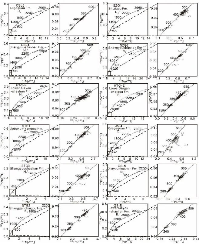
2.2.5 Sampling and analytical methods... 61
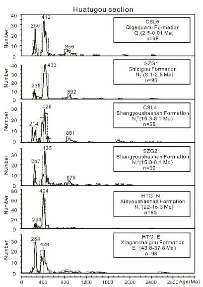
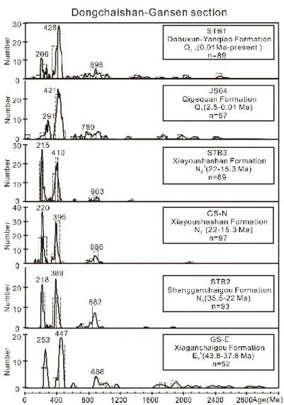
2.2.6 Results ... 63 2.2.6.1 Huatugou section ... 63 2.2.6.2 Dongchaishan-Gansen section ... 65 2.2.6.3 Kunbei section ... 68 2.2.6.4 Adatan section ... 70 2.2.6.5 Summary ... 71 2.2.7 Discussion ... 72
2.2.7.1 Pre-Paleocene exhumation of the Eastern Kunlun Range ... 72
2.2.7.2 Cenozoic source to sink relationship between the South Qaidam basin and the Eastern Kunlun Range ... 75
2.2.8 Conclusions ... 81
Acknolegdements ... 82
References Cited ... 82
Chapter 3 The interplay between the sediments within Qaidam basin and the active tectonic within Altyn Tagh Range ... 101
3.1 Initial rupture and displacement on the Altyn Tagh fault, northern Tibetan plateau: constraints based on residual Mesozoic to Cenozoic strata in the western Qaidam basin ... 101
Abstract ... 101
3.1.1 Introduction ... 102
3.1.2 Regional geology ... 104
3.1.2.1 Altyn Tagh Range ... 104
3.1.2.2 Qaidam basin ... 105
3.1.3 Residual Mesozoic-Cenozoic stratigraphy along the Altyn Tagh Fault ... 107
3.1.3.1 Mesozoic to Eocene strata in the Tula section ... 107
3.1.3.2 Cenozoic strata in the Anxi section ... 110
3.1.4 Methods... 112
3.1.4.1 Field investigation and seismic profile interpretation ... 112
3.1.4.2 Sampling and analytical process ... 113
3.1.5 Results ... 115
3.1.6 Discussion ... 118
3.1.6.1 New piercing points ... 118
3.1.6.2 Provenance analysis of Jurassic to Cretaceous strata ... 121
3.1.6.3 Implications for the initial timing and total offset of the ATF ... 124
3.1.7 Conclusions ... 128
Acknolegdements ... 129
References Cited ... 129
3.2 Large-scale displacement along the Altyn Tagh Fault (North Tibet) since its Eocene initiation: insight from detrital zircon U-Pb geochronology and subsurface data ... 142
Abstract ... 142
3.2.1 Introduction ... 143
3.2.2 Geological Background... 145
3.2.2.1 Altyn Tagh Range ... 145
3.2.2.2 Qaidam basin ... 146
3.2.3 Stratigraphy and sedimentary characteristics of the studied sections ... 147
3.2.3.1 Eboliang section ... 147
3.2.3.2 Huatugou section ... 150
3.2.4 Methods and analytical procedures ... 153
3.2.4.1 Detrital zircon geochronology ... 153
3.2.4.2 Seismic profile... 154
3.2.5 U–Pb geochronology results of detrital zircons ... 154
3.2.5.1 Eboliang section ... 157
3.2.5.2 Huatugou section ... 160
3.2.6 Discussion ... 163
3.2.6.1 Geochronological characteristics of potential sources for the sedimentary rocks in the western Qaidam basin ... 163
3.2.6.2 Provenance analyses of the Mesozoic-Cenozoic strata in the western Qaidam basin ... 165
3.2.6.3 Tectonics implications ... 173
3.2.7 Conclusions ... 176
Acknolegdements ... 176
References ... 177
Chapter 4 Quantitative estimate of the lateral extrusion along the Altyn Tagh Fault-Qilian Shan tectonic system ... 191
Abstract ... 191
4.1 Introduction ... 192
4.2 Geological setting ... 193
4.4 Results ... 198
4.5 Discussion and Conclusions ... 199
Acknowledgements ... 202
Reference ... 202
4.6 Chapter summary ... 209
Chapter 5 Strike-slip superimposed Qaidam Basin and its control on oil and gas accumulation ... 210
Abstract ... 210
5.1 Introduction ... 211
5.2 Similarities, differences and key points of the cognition ... 212
5.3 Structural features of peripheral Qaidam Basin ... 214
5.3.1 Altyn Tagh left-lateral strike-slip fault – North Qaidam thrust system ... 214
5.3.2 Left-lateral strike-slip of East Kunlun fault and its superimposed regulation on the basin since the Miocene ... 218
5.4 Structural control of the strike-slip superimposed Qaidam Basin on oil and gas accumulation .... 219
5.4.1 Distribution of sourcerocks in the Qaidam Basin ... 219
5.4.2 Control of strike-slip superimposed basin on oil and gas accumulation ... 222
Reference ... 223
Chapter 6 Conclusions and Follow-up research ... 230
6.1 General Conclusions ... 230 6.2 Follow-up research ... 231 Reference ... 232 Appendix ... 240 Appendix to Chapter 2.2 ... 240 Appendix to Chapter 3.1 ... 327 Appendix to Chapter 3.2 ... 356 Appendix to Chapter 4 ... 398
List of Figures and Tables ... 408
Figures to Chapter 1 ... 408
Figures to Chapter 2.1 ... 409
Figures and tables to Chapter 2.2 ... 412
Figures and tables to Chapter 3.1 ... 416
Figures and tables to Chapter 4 ... 422 Figures and tables to Chapter 5 ... 424 List of publications during the PhD. thesis work ... 426
Chapter 1 Preface
1.1 Introduction, Reginal Geology and Problems
Understanding the kinematics of the Asian tectonic system that contains one of the most diverse and complex patterns of active deformation on Earth not only has significant implications for deciphering the mechanisms of continental crust evolution or the interplay between lithospheric deformation and atmospheric circulation, but also contributes to exploring the crustal growth process of other planets within the solar system (Fig. 1; Molnar and Tapponnier, 1975; Tapponnier et al., 1982; England and Houseman,1986; Tapponnier et al., 1986; Cobbold and Davy, 1988; Davy and Cobbold, 1988; Molnar et al., 1993; Métivier et al., 1998; Meyer et al., 1998; Yin and Harrison, 2000; Tapponnier et al., 2001; Basilevsky and Head, 2007; Dupont-Nivet et al., 2007; Yin, 2010; Jolivet et al., 2015).
Though it is widely acknowledged that the Cenozoic deformation of East Asia was associated with the India-Asia continental collision and the subsequent post-collision convergence, how this extensive area developed has long been a puzzling question. Resolving that question has implications on the understanding of the mechanical behavior of the continental lithosphere in convergent zones as well as climate evolution on regional and global scale (Molnar and Tapponnier, 1975; Métivier et al., 1998; Yin and Harrison, 2000; Tapponnier et al., 2001; Garzione et al., 2005; Dupont-Nivet et al., 2007; Yin, 2010; Jolivet et al., 2015). In particular, the initial topography of the area now represented by the Tibetan plateau and the early stages of development of the present-day topography remain poorly constrained and highly debated (e.g. England and Houseman,1986; Yin and Harrison, 2000; Tapponnier et al., 2001; Wang et al., 2006; Kapp et al., 2007; Yin et al., 2007, 2008a, 2008b; Wang et al., 2008; Wang et al., 2014).
Fig.2 Digital topographic map of the Tibetan Plateau. Active fault kinematics and suture zones are mainly based on Yin et al. (2007), Taylor and Yin (2009), and Cheng et al. (2014, 2016).
The Qaidam basin is unique in the world in that it is the deepest intracontinental basin (>16 km thick of Cenozoic sediments alone), yet located in the highest plateau with the thickest continental crust. As the largest petroliferous basin on the Tibetan plateau, the triangular-shaped endorheic Qaidam basin is surrounded by the Altyn Tagh, the Qilian Shan,
and the Eastern Kunlun ranges, with ~2000 m of relief from the basin to the ranges (Figs. 2 and 3). The complete sequence of Cenozoic non-marine sedimentary rocks within the Qaidam basin as well as geological transects across the basin and ranges allow unraveling the formation mechanism and growth history of the Tibetan plateau, as well as the interplay between tectonics and climate. However, the Cenozoic evolution of the Qaidam basin and the Cenozoic kinematic evolution of the surrounding regions are highly debated, as briefly described below.
Fig.3 Geological map of the Qaidam basin, northern Tibetan plateau, modified from Chen et al. (2015). Seismic profile interpretations on the dip of the basement faults in the southwestern Qaidam basin are in dispute. Yin et al. (2007) proposed a series of south thrusting faults, whereas Cheng et al. (2014) and Wu et al. (2014) suggested those are south-dipping faults which are adopted in this study. Q-N23—
Quaternary to Late Miocene strata; N22—Middle Miocene strata; N21—Early Miocene strata; N1—
Oligocene strata; E32—Late Eocene strata; E31—Middle Eocene strata; E1+2—Paleocene to Early Eocene
strata.
In the past decades, several models have been proposed to explain the Cenozoic tectonic and sedimentary evolution of the Qaidam Basin. Most of those simply defined the tectonic pattern between the Eastern Kunlun Mountains and the Qaidam Basin through a northward or
southward thrusting model (Burchfiel et al., 1989; Meyer et al., 1998; Chen et al., 1999; Mock et al., 1999; Yin and Harrison, 2000; Jolivet et al., 2001; Tapponnier et al., 2001; Jolivet et al., 2003; Wang et al., 2006; Yin et al., 2007; Shi et al., 2009; Wang et al., 2011). The northward thrusting model prevailed during the last two decades, explaining the subsidence of the Qaidam Basin as a result of the basinward propagation of successive thrust sheets along the southern edge of the basin. Burchfiel et al. (1989) proposed that the southern edge of the Qaidam Basin is limited by a south-dipping thrust fault. Based on a synthesis of focal mechanisms and focal depth distribution combined with geological features, Chen et al. (1999) again speculated the existence of this south-dipping North Kunlun thrust fault along the northern margin of the East Kunlun belt. In addition, many authors indicated that northward basement thrusting across the Eastern Kunlun Mountains was associated to the northward propagation of a crustal-scale accretionary wedge initiating around ca. 30–20 Ma. (Fig. 4; Meyer et al., 1998; Mock et al., 1999; Jolivet et al., 2001; Tapponnier et al., 2001; Jolivet et al., 2003; Wang et al., 2006). These ideas suggest that the Eastern Kunlun Mountains consists in a large transpressional system limited to the south by the left-lateral strike slip Kunlun fault and to the north by a series of south-verging basement thrusts affecting the southern edge of the Qaidam Basin.
Fig.4 Northward propagation model, modified from Meyer et al. (1998). Note the south-dipping fault in the southern Qaidam basin.
The southward thrusting model has drawn much attention in recent years (Fig. 5; Yin et al., 2007; 2008; Shi et al., 2009; Wang et al., 2011). Yin and Harrison (2000) suggested that two major thrusts, the Qimen Tagh Thrust and the North Kunlun Thrust mark the southern boundary of the Qaidam Basin. Using seismic profiles within the Qaidam Basin as well as field observations, Yin et al. (2007) then proposed that the low altitude Qaidam Basin has been thrust onto the Eastern Kunlun Mountains along a major north dipping Cenozoic thrusts. Wang et al. (2011) later expanded this model based on a high-resolution deep seismic reflection
profile across this area. This model indicates that the Eastern Kunlun Mountains should not thrust northward onto the Qaidam Basin and that the initiation of compressive deformation along the southern margin of the Qaidam Basin is much younger than along the northern margin of the basin.
Fig.5 Southward propagation model, modified from Yin et al. (2008a). Note the south-thrusting fault in the southern Qaidam basin.
Other tectonic models have been proposed aside from the two main ones described above. Xia et al. (2001) proposed that the Qaidam Basin experienced a two stages evolution: an initial extension phase during the Early Tertiary was followed by a compressive phase leading to basin inversion. However, few seismic profiles in the western Qaidam Basin have revealed any extensional faults during the Early Tertiary. Meng and Fang (2008) suggested that the Cenozoic tectonic subsidence of the Qaidam Basin resulted from crustal folding or buckling in response to regional horizontal compression. However, the seismic profiles across the whole Qaidam Basin imply that the magnitude of Cenozoic upper crustal shortening decreases eastward across the basin from >48% in the west to <1% in the east (Yin et al., 2008a). In particular, the proposed onset time of uplift of the Eastern Kunlun Range mainly varies from Eocene to Miocene, depending on the approach used to estimate the onset of deformation (Mock et al., 1999; Jolivet et al., 2001; Yuan et al., 2006; Yin et al., 2007, 2008a; C. Wang et al., 2008; Clark et al., 2010; Dai et al., 2013; Duvall et al., 2013). Based on regional stratigraphic correlation between the Qaidam Basin and the Hoh Xil Basin to the south, Yin et al. (2008a) argued that they represented a single basin during the Paleogene, bounded to the north by the Altyn Tagh Range and the Qilian Shan, and to the south by the proto–Tibetan Plateau. This large structure was then partitioned by the tectonic uplift of the Eastern Kunlun
Range during the Neogene. This model questions the assumption of a progressive northward growth of the plateau through in-sequence propagation of thrust systems associated with filling of the intermediate basins (e.g., Métivier et al., 1998; Meyer et al., 1998; Tapponnier et al., 2001). This idea has motivated several attempts to reassess the tectonic processes affecting the northern edge of the Tibetan Plateau (e.g., Shi et al., 2009; Wang et al., 2011; Mao et al., 2014; Yu et al., 2014).
Fig.6 Qaidam basin model, cited from Yin et al. (2008a). Note that during the Paleogene, the Paleo-Qaidam basin lies between the elevated Lhasa block and the Fenghuo Shan thrust belt in the south and the elevated Qilian Shan in the north. The region north of the Tibetan plateau was a large topographic depression that links Tarim and Junggar basins across the Tian Shan, as the Tian Shan was not uplifted until the early Miocene. The initiation of the Eastern Kunlun left-slip transpressional system caused the uplift of the Eastern Kunlun Range, which has partitioned the PaleoQaidam basin into the Hoh Xil basin to the south and the Qaidam basin to the north.
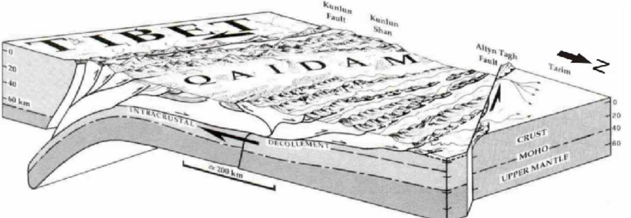
As the northwestern boundary of the Qaidam basin, the sinistral strike-slip Altyn Tagh fault plays a significant role in the Cenozoic deformation of northern Tibet (Fig. 7). Understanding the Cenozoic kinematic pattern of the Altyn Tagh fault holds important implications for unraveling the evolution of northern Tibet, deciphering the growth history of the entire Tibetan Plateau, and contributing to oil and gas exploration in the surrounding region (Fig. 2; Yue and Liou, 1999; Yin and Harrison, 2000; Tapponnier et al., 2001; Yin et al., 2002; Wang et al., 2014). Recent studies have revealed much about the large-scale geology of the Altyn Tagh Range and the surrounding region (Wang, 1997; Yue et al., 2001; Yin et al., 2002;
Chen et al., 2003; Cowgill et al., 2003; Dupont-Nivet et al., 2003, 2004; Ritts et al., 2004; Wu et al., 2012a, 2012b; Lu et al., 2014; Zhang et al., 2014). However, the immense size and extent of the Altyn Tagh Range make it difficult to locate ideal piercing points with which to estimate the initial timing of left-slip movement and total displacement along the Altyn Tagh fault. As a result, both the timing and amount of slip along the fault are vigorously debated (e.g., Yin et al., 2002; Cowgill et al., 2003; Gehrels et al., 2003a, 2003b; Ritts et al., 2004; Wu et al., 2012a, 2012b). Although some studies reference Mesozoic shearing in the Altyn Tagh Range (Arnaud et al., 2003; Wang et al., 2005; Li et al., 2006; Liu et al., 2007), the growth of the Tibetan Plateau is largely related to Cenozoic faulting along the Altyn Tagh fault rather than to any pre-Cenozoic shearing in the Altyn Tagh Range (Tapponnier et al., 2001). Various approaches have been used to constrain the initial timing of left-lateral slip movement along the Altyn Tagh fault, and the estimates vary greatly. Initial movement along the Altyn Tagh fault is estimated to have occurred broadly between the Eocene and Miocene epochs (Chen et al., 2001; Jolivet et al., 2001; Meng et al., 2001; Wan et al., 2001; Yue et al., 2001; Yin et al., 2002; Robinson et al., 2003; Wu et al., 2012a, 2012b), and estimates of the total displacement along the Altyn Tagh fault vary anywhere from ~1200 km to less than 90 km (Tapponnier et al., 1986; Wang, 1997; Yin and Harrison, 2000; Yang et al., 2001; Yin et al., 2002; Cowgill et al., 2003; Gehrels et al., 2003a, 2003b; Ritts et al., 2004). The wide variety of estimates regarding the initial timing and offset of the Altyn Tagh fault highlight the incomplete understanding of this remote region.
Fig.7 Simplified tectonic map of northern Tibet showing major tectonic terranes, sutures, and faults (modified from Yin et al., 2002). Cenozoic stratigraphic sections (locations shown by turquoise blue squares) were measured by this study at Aertashi, Puska, Jianglisai, and Xishuigou in the southern Tarim Basin. Other relevant stratigraphic sections are Mangnai, Lenghu, Lulehe, Xorkoli, and Jiuxi (Hexi Corridor). Map symbols: N-Q—Neogene–Quaternary sediments, Ts—Tert iary sedimentary
rocks, THS—Tethyan Himalayan sequences (Proterozoic to Upper Cretaceous passive-continental-margin strata of northern India), GHC—Greater High Himalayan Crystalline Complex, LHS—Lesser Himalayan metasedimentary series. Major plutonic rocks: Czgr—Cenozoic granites, K-Tgr—plutonic rocks belongi ng to the Gangdese batholith, Ladakh batholith, and Kohistan arc, gr(Q)—plutonic rocks
in the Qiangtang terrane (mostly Jurassic–Cretaceous), gr(SP)—plutonic roc ks in the Songpan–Ganzi– Hoh Xil terrane (mostly Late Triassic), gr(KQ)—Ordovician–Silurian and Permian–Triassic plutonic rocks in the Kunlun and Qilian terranes. Major sutures: IYS—Indus-Yalu suture, BNS—Bangong-Nujiang suture, JS—Jinsha suture, AKMS—Ayimaqin-Kunlun-Mutztagh suture, KS—Kudi suture, MCT—Main Centra l thrust, MKT—Main Karakoram thrust, STDS—South Tibet detachment system.
Finally, with regard to the northeastern boundary of the Qaidam basin, the Qilian Shan separates the plateau from the Gobi-Alxa block to the northeast (Fig. 8). This crustal-scale wedge consists of massive NW-SE striking mountain ranges growing on folds, thrusts or strike-slip faults accommodating the northward motion and eastward extrusion of the Tibetan Plateau (Meyer et al., 1998; Yin and Harrison, 2000; Tapponnier et al., 2001; Bovet et al., 2009). The proposed Palaeocene to early Eocene initiation of the Cenozoic deformation and crustal shortening in the Qilian Shan (Jolivet et al. 2001; Yin et al., 2008; Clark et al., 2010; Duvall et al., 2011; Zhuang et al., 2011; Yuan et al., 2013) challenges the model of post-Pliocene initial deformation in the northern Tibetan plateau inferred from the hypothesis of northward progressive plateau growth (Métivier et al., 1998; Meyer et al., 1998; Tapponnier et al., 2001). Although large amounts of NE-SW directed shortening and eastward motion of the northern Tibetan crust have long been observed (e.g. Tapponnier and Molnar, 1977; Burchfiel et al., 1991; Dupont-Nivet et al., 2004; Zhang et al., 2004), the proposed amounts of Cenozoic crustal shortening vary widely from ~20% to ~60% (Bally et al., 1986; Meyer, et al., 1998; Yin et al., 2008a, 2008b; Zhang et al., 2014) and quantitative estimation of the amount of lateral extrusion in the northeastern Tibetan Plateau is deficient.
Fig.8 Topographic map of northern Tibet showing major tectonic terranes and faults within the Qilian Shan.
1.2 Research plan and framework of the dissertation
My PhD dissertation focuses on four key issues that contribute to understand the evolution of the Qaidam basin itself and kinematic history of the entire Tibetan plateau since the onset of the India-Asia collision: 1) The Cenozoic tectonic evolution between the Qaidam
basin and the Eastern Kunlun Range; 2) The interplay between the sediments within the Qaidam basin and the active tectonic within the Altyn Tagh Range; 3) The quantitative estimate of the lateral extrusion along the Altyn Tagh Fault-Qilian Shan tectonic system; 4) The classification of the Qaidam basin: Foreland basin or Strike-slip superimposed basin?
Firstly, I discuss the Cenozoic tectonic evolution between the Qaidam basin and the Eastern Kunlun Range in Chapter 2. I subdivided this issue into two parts: Chapter 2.1 Tectonic relationship between the Eastern Kunlun Range and the Qaidam basin, and Chapter 2.2 Cenozoic source to sink relation between the Qaidam basin and the Eastern Kunlun Mountains. In the first part, I analyze newly acquired 3D seismic-reflection profiles within the SW Qaidam basin, isopach maps of the Cenozoic strata in the SW Qaidam basin, remote sensing images in the Qimen Tagh Range, and earthquake focal mechanisms and epicenter distribution within the Qaidam basin, in order to re-evaluate the tectonic pattern along the western portion of the Kunlun fault and to decipher the Late Cenozoic interaction between the Eastern Kunlun Range and the SW Qaidam basin. I published this work in Tectonophysics as first author. Concerning the Cenozoic source to sink relation between the Qaidam basin and the Eastern Kunlun Mountains, I conducted field investigation, detrital zircon geochronology analysis combined with the seismic profile interpretation, in order to characterize the nature of the relation between the Eastern Kunlun Range and the Qaidam Basin, and present a clear image on the source to sink relation between these two regions. I published this contribution in Geological Society of American Bulletin as first author.
Secondly, in order to constrain the initial timing and kinematic pattern of movement along the Altyn Tagh fault, I present a detailed analysis of the stratigraphy, sediment types, and detrital zircon U-Pb ages combined with seismic profile data along three sections (Tula, Anxi, and Caishiling sections) of the western segment of the Altyn Tagh fault in Chapter 3.1. I also carried out a detailed analysis of the stratigraphy and detrital zircon geochronology of four key lithologic sections (Tula, Anxi, Caishiling and Eboliang) along the Altyn Tagh fault, presented in Chapter 3.2. I published part of this work in Geosphere as first author (see Chapter 3.1), while submitted the other part to Tectonophysics again as first author (see Chapter 3.2). This last manuscript as been accepted with minor revision.
Thirdly, my work on the quantitative estimate of the lateral extrusion along the Altyn Tagh Fault-Qilian Shan system which is a follow-up research of issue 2 (i.e. the initial timing and kinematic patterns of movement along the Altyn Tagh fault). The lithospheric strike-slip Altyn Tagh fault has accommodated hundreds of kilometers of displacement (~360 km) between the Qaidam and Tarim blocks since its Eocene reactivation. However, the way the
deformation is accommodated in the Qilian Shan and further east remains uncertain. I propose a new quantitative evaluation of the Cenozoic crustal shortening and lateral extrusion budget in the northern Tibetan plateau, based on my 360 km estimation of north-eastward migration of the relatively rigid Qaidam block along the Altyn Tagh fault, and 3D isovolumetric balancing of the crustal deformation within the Altyn Tagh fault–Qilian Shan system. I published this work in Terra Nova as first author, and present it in Chapter 4.
Finally, in order to classify the peculiar Qaidam basin (Foreland basin or Strike-slip superimposed basin), I review the recent arguments on the Cenozoic evolution of the Qaidam baisn and summarize the kinematic features within the Qaidam basin and surrounding regions based on the abovementioned findings combined with recent petroleum exploration achievements in recent years (e.g. distribution of source rocks in the Qaidam basin). I conclude that the Qaidam basin is a strike-slip superimposed basin jointly controlled by the left-lateral strike-slip Altyn Tagh and East Kunlun faults. The temporal and spatial superimposition of these two strike-slip faults during the Cenozoic controlled the evolution of the basin as well as the oil and gas accumulation. This work is presented in Chapter 5. I have published this contribution in Petroleum Exploration and Development as co-author.
Chapter 2 Cenozoic tectonic evolution between the Qaidam basin
and the Eastern Kunlun Range
2.1 Tectonic relationship between the Eastern Kunlun Range and the Qaidam
basin
Paper published in Tectonophysics, 2014, vol. 632, pp. 32-47
Northward growth of the Qimen Tagh Range: a new model accounting for the Late Neogene strike-slip deformation of the SW Qaidam Basin
Feng Cheng a, Marc Jolivet b, Suotang Fu c, Qiquan Zhang c, Shuwei Guan d, Xiangjiang Yu a,
Zhaojie Guo a, *
a Key Laboratory of Orogenic Belts and Crustal Evolution, Ministry of Education, School of
Earth and Space Sciences, Peking University, Beijing, 100871, China
b Laboratoire Géosciences Rennes, CNRS-UMR6118, Université Rennes 1 - Observatoire des
Sciences de L’Univers de Rennes, Rennes, France
c Qinghai Oilfield Company, PetroChina, Dunhuang, Gansu, 736202, China
d Research Institute of Petroleum Exploration and Development, PetroChina, Beijing, 100083,
China
* Corresponding author. Tel.: + 86-10-62753545; fax: + 86-10-62758610. E-mail address:
zjguo@pku.edu.cn
Note: The online version of this contribution can be found as: Cheng, F., Jolivet, M., Fu, S.,
Zhang, Q., Guan, S., Yu, X., Guo, Z., 2014. Northward growth of the Qimen Tagh Range: A new model accounting for the Late Neogene strike-slip deformation of the SW Qaidam Basin. Tectonophysics 632, 32-47, doi:10.1016/j.tecto.2014.05.034
Abstract
Situated along the western termination of the Eastern Kunlun Mountains, the Qimen Tagh Range represents a key area to understand the Cenozoic basin-range interactions between the northeastern Tibetan Plateau and the Qaidam Basin. Within that region, several huge bow-like
fault systems such as the Kunbei and Qimen Tagh fault systems accommodate the transpressive deformation but their kinematic evolution is still highly debated. Newly acquired seismic profiles and isopach maps of the Late Eocene sediments strongly suggest that the Kunbei fault system (consisting of the Kunbei, Arlar and Hongliuquan faults) in the southwestern Qadaim Basin was initially a left-lateral strike-slip fault system rather than a thrusting system. Growth strata indicate an Early Miocene onset age for this strike-slip deformation. However, earthquakes focal mechanisms show that the present-day tectonic pattern of this fault system is dominated by NE-SW transpression. As for the Qimen Tagh fault system, numerous linear geomorphic features and fault scarps indicate that it was again a strike-slip fault system. Deformed sediments within the Adatan Valley prove that strike-slip motion prevailed during the Pleistocene, yet the present day deformation is marked by NE-SW transpression. Collectively, the Kunbei and Qimen Tagh fault systems were initially left-lateral strike-slip fault systems that formed during Early Miocene and Pleistocene respectively. Colligating with these southward younging left-lateral strike-slip faulting ages and the fact that these convex-northward structures converge to the center segment of active Kunlun Fault in the east, we thus considered the Kunbei and Qimen Tagh fault systems as former western segments of the Kunlun Fault once located further south in the present-day location of that fault. These faults gradually migrated northward since the Early Miocene while their kinematics changed from left-lateral strike-slip motion to NE-SW transpression.
Keywords: Cenozoic tectonics, North Tibet, Kunlun Fault, Qimen Tagh Range, southwestern Qaidam Basin.
2.1.1 Introduction
The Eastern Kunlun Mountains and adjacent Qaidam Basin present one of the strongest topographic gradients in Eurasia, similar to that of the Longmen Shan Range in East Tibet (Fig. 1). Within that region, the left-lateral strike-slip Kunlun Fault Zone represents one of the key tectonic features controlling the active deformation along the northern margin of the Tibetan Plateau (e.g. Avouac and Tapponnier, 1993; Meyer et al., 1998; Jolivet et al., 2001; Tapponnier et al., 2001; Xia et al., 2001 ;Yin et al., 2007). Most of the previous studies that dealt with the Tertiary deformation in the East Kunlun ranges focused on the central and eastern segment of the Kunlun Fault (Kirby et al., 2007; Harkins and Kirby, 2008) where the deformation is mostly localized along the major, unique strike-slip fault zone. However, only a limited number of studies describe the more structurally complex western termination of the
Kunlun Fault system (Jolivet et al., 2001, 2003).
Although the Cenozoic tectonic evolution of North Tibet has been largely studied, the relationship between the Qaidam Basin and the East Kunlun Range, as well as the tectonic pattern of the Kunlun Fault itself, remains controversial. For example, several contradicting models have been proposed to describe the tectonic structure of the southern edge of the Qaidam Basin: a crustal-scale south-dipping thrust system (Burchfiel et al., 1989); a large transpressional system including the left-lateral strike - slip Kunlun Fault to the south and a north - directed thrust system along the northern flank of the Eastern Kunlun Mountains (Meyer et al., 1998; Tapponnier et al., 2001; Jolivet et al., 2003); or a series of north - dipping thrusts carrying the Qaidam Basin southward onto the Qimen Tagh Range (Yin et al., 2007; Shi et al., 2009; Wang et al., 2011). Within most of those models, the large amount of Cenozoic strike-slip motion along the Kunlun Fault (Fu and Awata, 2007) is generally considered as secondary in controlling the overall structural setting of the SW Qaidam Basin and East Kunlun Range. However, if the boundary fault between the Qaidam Basin and the East Kunlun Range was indeed accommodating a large amount of lateral displacement, the southern Qaidam Basin should be largely decoupled from the Tibetan Plateau to the south and should not be affected by major N-S compression and shortening since the initiation of the strike-slip Kunlun Fault. Nonetheless, the Qimen Tagh Range, bordering the SW Qaidam Basin to the south forms a convex-northward bow-like tectonic prism clearly accommodating shortening along the southern margin of the basin while strike-slip motion occurs along the Kunlun Fault to the south.
Fig.1 Digital topographic map of the western Qaidam Basin and surrounding area. Topography from SRTM data.