HAL Id: hal-00368579
https://hal.archives-ouvertes.fr/hal-00368579
Preprint submitted on 17 Mar 2009HAL is a multi-disciplinary open access
archive for the deposit and dissemination of sci-entific research documents, whether they are pub-lished or not. The documents may come from teaching and research institutions in France or abroad, or from public or private research centers.
L’archive ouverte pluridisciplinaire HAL, est destinée au dépôt et à la diffusion de documents scientifiques de niveau recherche, publiés ou non, émanant des établissements d’enseignement et de recherche français ou étrangers, des laboratoires publics ou privés.
Exposure to Volcanic Hazards, and Influence on
Perception: A Case Study in Japan, Ten Years After the
Unzen Fugendake Eruption
Christopher Gomez
To cite this version:
Christopher Gomez. Exposure to Volcanic Hazards, and Influence on Perception: A Case Study in Japan, Ten Years After the Unzen Fugendake Eruption. 2006. �hal-00368579�
Exposure to Volcanic Hazards, and Influence on Perception:
A Case Study in Japan, Ten Years After the Unzen Fugendake Eruption
*Gomez Christopher *: corresponding author : kurisusing@hotmail.com /
Christopher.Gomez@cnrs-bellevue.fr
Laboratoire de Géographie Physique LGP Pierre Birot, 01 Place Aristide Briant, 92195 Meudon, France.
Tel : 81(0)80 5427 2880
Abstract
This study aims at understanding the perception of volcanic hazards that adults and pupils have in the province of Nagasaki Kyushu, ten years after the volcanic eruption of the Unzen Fugendake. The Unzen Fugendake started to erupt in 1991 and produced several pyroclastic flows lahars and ashes rains. Shimabara city, located on the foot of the volcano was severely stroke by the eruption. Ten years after this eruption, a study was carried on in Shimabara city and in Saikai city – away from any volcano - to compare the inhabitants’ perceptions of volcanic hazards and the importance they have among other natural hazards. This study was carried on through questionnaires and interviews for the adults, as for the pupils we collected drawing, completed by informal interviews. From this survey, we can observe some signs of trauma among people who had been under direct exposure of the eruption, whereas indirectly exposed respondents did not show any sign of it. It seems that natural hazards’ personal experience is always considered like the most important whenever the scale of the natural hazards that are compared. In Shimabara, majority of the respondents consider that the Unzen’s eruption was the worst disaster in Japan for the twenty last years,
whereas Saikai city’s inhabitants hardly mentioned it, highlighting the “o-ame” event that triggered exceptional floods in Nagasaki city and in their own town. In the end, this study is also showing the difference between pupils and adults’ perceptions. Indeed the first diverging point concerns the fact that pupils are highlighting the natural hazard itself, whereas adults preferentially highlighted the vulnerability of human beings and constructions. The second diverging point between adults and pupils is the fact that both cities children’ perceptions do not vary as much as adults’ ones do. Due to the absence of any direct exposure to volcanic eruption, the children’ perception seems to tend towards some homogeneity, based on second-hand information.
Keywords:
Unzen; Nagasaki; Kyushu; Japan; Volcano; Eruption; Perception; Natural Hazards; Natural Hazards’ exposure; pupils perception; trauma
1. Introduction
Japan is the third country for volcanic disasters, with 8% of the world fatalities due to volcanic hazards these last 4 centuries. Volcanic disasters can be defined as interactions between extreme volcanic events and vulnerable human populations (adapted from Blaikie et al., 1994). From 1991 to 1995, the town of Shimabara located on the foot of the Unzen volcano was stricken by its eruption, resulting in 43 fatalities and a reconstruction that cost almost US$2 billion (source: ministry of land and infrastructure). The eruption, its consequences and the authorities’ actions were widely reported through the media all over Japan becoming of a
national concern. Ten years after this disaster, this study aims at assessing the volcanic hazards’ perception among inhabitants in Nagasaki Province, and more specifically to compare perception of population under the threat of a volcano and people not having any contact with a volcano in their everyday life.
1.1 The 1991-1995 eruption of Unzen volcano
The Unzen volcano - 1486 m. a.s.l. at Heiseishinzan - is located in the Nagasaki province to the West of Shimabara city (fig. 1). The Unzen is well-known for Japan’s greatest volcanic disaster (Mount Mayuyama): in 1792 around 15.000 people were killed by a massive landslide from Mount Maruyama which devastated Shimabara city, and entering in the sea generated a series of tsunamis (Akagi, 2001; Brantley and Scott, 1993; Furuya, 1974). According to Katayama (1974), 14.528 died, 1518 people were injured, and 5972 houses were devastated around the Ariake Bay (tab. 1).
Shimabara City TOTAL
Casualties 9,532 14,528
Injuries 707 1,518
Destroyed buildings 3,347 5,972
Devastated fields
(ha) 378 3,082
Tab.1 : Damages after the Mayuyama disaster (Katayama, 1974)
In 1990 the volcano awakened again (Nakada & al., 1999; Ohta, 1991) for 5 years creating a new lava dome at the summit area of the Fugendake (Hoshizumi & al., 1999). This event started by phreatomagmatic eruptions in April-May 1991, and the lava dome began to grow in August 1991 to reach 1,2 Km long and 0.8 Km
wide for a thickness ranging from 230m to 540m (Nakada et al.,1998). Domes’ collapses generated pyroclastic flows, which 99% were of Merapi types. The first observed pyroclastic flows swept the Mizunashigawa valley in May 1991 and most of them occurred during the 1991-1993 periods that coincide with the exogenous dome growth (Tadahide et al., 1998). The Unzen Fugendake produced 9400 block-and-ash flows until 1995 (Miyabuchi, 1999) as frequently as 10 small pyroclastic flows a day and until 504 for the only month of September 1991 sweeping until 5,5 km from the dome (Brantley and Scott, 1993) killing 43 people – including French and American volcanologists.
Fig. 1: Unzen volcano, Shimabara and Saikai cities’ locations in Nagasaki province – south Japan, and the survey network around the Unzen volcano.
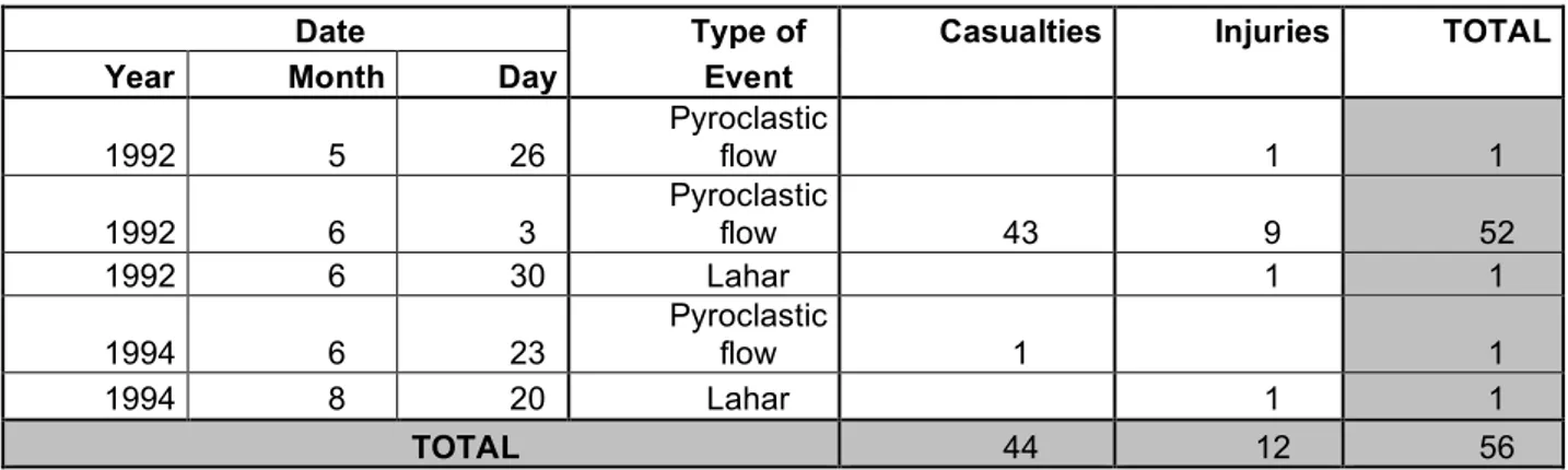
Date Type of Casualties Injuries TOTAL
Year Month Day Event
1992 5 26 Pyroclastic flow 1 1 1992 6 3 Pyroclastic flow 43 9 52 1992 6 30 Lahar 1 1 1994 6 23 Pyroclastic flow 1 1 1994 8 20 Lahar 1 1 TOTAL 44 12 56
Tab.2: Casualties and Injuries in Shimabara city after the Unzen eruption in 1991-1995 (Shimabara city hall, 2003)
Date Type of Houses Other All
Year Month Day Event Buildings Buildings
1992 5 15 Lahar 1 1 1992 6 3 Pyroclastic Flow 49 130 179 1992 6 8 Pyroclastic Flow 72 135 207 1992 6 11 Rock Avalanche 11 11 1992 6 30 Lahar 98 104 202 1992 9 15 Pyroclastic Flow 53 165 218 1993 8 8 Pyroclastic Flow 5 12 17 1993 8 8-15 Lahar 164 80 244 1994 4-5 28-2 Lahar 372 207 579 1994 6 12-16 Lahar 48 33 81 1994 6 18-19 Lahar 135 72 207 1994 6 22-23 Lahar 49 29 78 1994 6 23-24 Pyroclastic Flow 92 95 187 1994 7 4-5 Lahar 18 7 25 1994 7 16-18 Lahar 63 20 83 1994 8 19-20 Lahar 170 22 192 TOTAL 1399 1112 2511
Tab. 3: Damages in Shimabara city due to the 1991-1995 eruption at Unzen volcano (Shimabara city hall, 2003).
According to Blong (1984), two of the factors that influence the social effects of an eruption on a community include (1) the nature of the volcanic hazards, (2) the deaths, injuries and damage incurred. In Shimabara fatalities remained little thanks to the population evacuation, since only 43 people died over this eruption (tab. 2). However building and infrastructure damages were important. Volcanic eruptions affect buildings through a variety of damage mechanisms. Indeed building may suffer collapse, burial, transport, foundation failure, undermining, racking, excessive wall or roof loads, impacts from ballistic projectiles, corrosion, or catch fire (Blong, 1984). The most destructive agent on Unzen volcano during the 1991-1995 eruption was lahars. From 1991 to 1995, lahars sweeping Unzen’s valleys destroyed more than 1700 buildings. The second most destructive agent was pyroclastic flows. From 1991 to 1995, pyroclastic flows destroyed 808 buildings in Shimabara city (tab. 3).
1.2 The Unzen, a highly monitored volcano
The Unzen volcano has been systematically belted by a monitoring system including 13 automatic telemetered raingauges to survey the volume and intensity of rainfall pouring on the volcano, and that can potentially trigger lahars (fig. 1). This system is completed by a rainfall’s radar located in the village of Futsucho. The raingauges and the radar are completed by sensors rigged on SABO dams to compute lahars’ magnitudes. This system is wired to automatic video-camera recording the various lahars activities. This equipment is the first cell of a complete monitoring and population warning system (fig. 2).
Also belting the volcano, a SABO dam system is protecting the volcano’s surroundings against lahars. Sabo dams were created to stop, trap or slow down sediments carried by lahars (fig. 3).
Fig. 2: The post-eruption lahars’ warning system on the Unzen volcano.
On the North-western flank, in the Nakaogawa, a series of 8 SABO dams were built between the altitude 270m and 350m in order to protect Shimabara city and upstream the Shinzan SABO dams 1 and 2. On the Northern flank, along 1 km; a series of 15 SABO DAMS oriented East-West between 300m and 450m a.s.l. create a “staircase” meant to slow down the eventual lahars’ runoff. Those “Oshigatani-shinzan” dams present a broad concrete structure 100m to 200m wide. Downstream to the East, 3 major SABO dams cross the Mizunashigawa valley. The SABO dam located around 1700m a.s.l. is a slit dam which is meant to stop the largest blocks with its series of 16 seven meter high pillars. The two other dams are located downstream around 500m a.s.l. and 1100 m a.s.l., and are built like enormous reservoir for sediments. Then two series of 15 side protection dikes are canalizing the eventual flow towards the sea to avoid any flood towards the inhabited areas.
This SABO dam prevention system is completed by an active program that aims at stopping the rainfall triggered lahars with an artificial vegetation return. The Regional & National Forestry Offices and the Shimabara Town-hall set up a program of pyroclastic deposits’ stabilization on the Fugen-Dake Heisei Shinzan’s flanks by accelerating the return of vegetation. It is not so much to protect population against lahars, but to avoid lahars triggering processes. Two methods have been used. For the upper part of the volcano, the most hazardous one, seeds have been spread out from an helicopter, and in the distal zones, the helicopter spread has been completed with trees plantations. The total surface regain by vegetation is around 1360 ha including 1344 in the main valleys
touched by pyroclastic flows: Akamatsu, Mizunashigawa, Ashigatani, Nakaogawa and Yuegawa.
1.3 Inhabitants’ characteristics: an aging population
Both cities, Shimabara and Saikai are showing pretty similar inhabitants’ evolution patterns, even though Shimabara city is showing some specificity due to the volcanic eruption.
These last 20 years, Shimabara’s population has been decreasing from 46.061 in 1986 to 38.959 in 2005. The number of inhabitants over 65 years old has been increasing whereas other classes have been decreasing. Indeed, inhabitants below 15 years old were 10436 in 1986 and only 5611 in 2005, 15 to 64 were 29394 in 1986 and 23192 in 2005. As for the over 65 years old, they pass from 6231 to 10156 from 1986 to 2005. The aging population process over this period has been accentuated by the volcanic eruption from 1991 to 1995 because young generations fled from the city (fig. 4).
The population of Saikai city has been decreasing of -5,6% these last 20 years. The population that reached 9385 inhabitants in 1986 was only 8854 in 2005. As for Shimabara city, the number of over 65 years old inhabitants has been increasing from 1550 to 2555. Population below 65 years old has been decreasing. Below 15 years old were 1954 in 1986, and only 1364 in 2005, whereas 15 to 65 years old were 5878 in 1986, and 4935 in 2005 (fig. 5).
Fig.4: Population evolution in Shimabara city from 1986 to 2005.
1.4 Objectives and hypothesis
This study aims at understanding the way residents of the Nagasaki province perceive, and evaluate the volcanic risks either if they are living near a volcano – here the Unzen – or more especially out of direct sight and influence of this one. Risks’ perception queries are a major stake for decision making processes and scientists, since people have their own perception of risks based on different criteria than scientists (D’Ercole, 2006). This fact was verified during the Unzen eruption in 1990. Indeed, despite evacuations ordered by the Japanese authorities, many peopled ignored the warnings because they did not have any knowledge of pyroclastic flows related risks, or thought pyroclastic flows would not reach their home (Yoshii, 1992). This perception has surely changed after the eruption, in Shimabara and elsewhere in Japan, since the Unzen eruption became of national concern, largely broadcasted on television. Therefore, ten years after the eruption, this paper tries to understand the influence of direct and indirect exposure to a volcanic hazard, and the perception of two populations, one under a direct threat of volcanic hazards and one other apparently without any volcanic hazards’ concern.
This study is supported by a few hypothesis: (1) Firstly, in a country under the threat of numerous natural hazards, it is interesting to understand the place volcanic hazards have among all the natural hazards, and understand if the populations feel likely to be stricken by volcanic hazards rather than other hazards (Johnston et Benton, 1998). (2) Volcanic hazards’ perception is also certainly guided by the mean of information. We can observe direct exposure to the risks – personal experience - and indirect exposure through media for example, and this
should greatly change the populations’ risks perception. For example, the data collected in may 1980 around St-Helens volcano which attests views exposed by the interviewed inhabitants were tinted by those expressed by volcanologists on the news (Greene et al., 1981; Perry et al., 1980). The perception change then with the mean of information, which is itself controlled by the distance to the volcano (Blong, 1984, Greene et al., 1981; Sorenson, 1981). (3) Volcanic hazards perception is also influenced by the interviewed inhabitants’ age (Ronan, 1998, Ronan et al., 2001), therefore adults and pupils’ perception must be slightly different
2. Methodology
2.1 The population sample and respondents’ profile:
To carry out this study, the sample consisted in 400 participants recruited on a voluntary non paid basis. These participants can be divided into two groups depending on their reply to a questionnaire or answers through drawings. Both adults and children groups are composed of 200 participants each. The adult group is composed of respondents from the last grade of Junior High School to elderly, while children include students from eight to eleven years old – 4th grade to 6th grade of elementary school. The children age repartition was pretty equal in between 4th, 5th and 6th grade since querying was conducted in school classes. As for the adults’ 5% in Saikai city and 21,5% in Shimabara-city were less than 20 years old, 12% and 18% were between 20 and 35 years old in respectively Saikai-city and Shimabara-Saikai-city. The population comprised between 35 and 65 years old
were for both town the most numerous with 35% and 40%, and population over 65 years old were 31% and 19,5% for respectively Saikai-city and Shimabara-city. For Saikai and Shimabara cities 2,5% and 5% of respondents did not include the information about their age. In the end, the respondents’ gender was represented by 60,4% by women and 39,6% by men.
2.2 Location choices
Queries were conducted in Shimabara city and Saikai city. Shimabara was choosen for this study because of its proximity to the volcano, since the city is located on the foot of the Unzen. Shimabara’s counter part for this study is Saikai-city. This choice was driven by different reasons. Firstly Saikai city is 70km away from Shimabara and do not have any volcano in its surrounding. Indeed, if you are going eastward or southward from the Unzen you can find respectively the Aso volcanic complex, and the Sakurajima. Secondly, Shimabara and Saikai city are separated by Nagasaki city in between. Therefore Saikai city is partly polarized by Nagasaki city and do not entertain any obvious economical or cultural link with Shimabara city and the Unzen volcano. In the end, practical reasons drove the choice of Saikai-city: the author was living in this locality for more than a year, therefore personal and professional networks were of great help to conduct this study. Therefore Saikai city seemed a good counterpart for Shimabara city.
2.3 Procedure
For the questionnaire, each participant received one from the author or friends and acquaintance that helped for this study. Then, the respondents were invited to answer the questionnaire individually within a one month time period. They were encouraged to use a dictionary for difficult terms, and questionnaire given to the elderly were explicit with “furigana” of each kanji – phonetical pronunciation of each difficult Chinese sign used in Japanese language. Participants were also asked to circle terms they did not know or did not know the reading way. Once the questionnaire handed back to the author, a few interviews or questions were informally conducted, mostly on weekends at their home. For the drawings, they were conducted with the help of local teachers or parents, mostly at school during an hour school lesson. The students were undergoing a short talk on natural disasters with their teachers or parents, and then were asked to draw what they were thinking about when told about natural disaster. The exercise lasted for one hour the most. Some time later, students were approached in order to better understand what they have been drawing. These interviews were mostly conducted quite informally at respondents’ home or on the school ground while playing during school breaks. The choice to keep the children in a familiar environment was motivated by the will of not creating too much stress to the children that could modify their answers.
2.4 Questionnaires’ contents
Questionnaires were archived according to queried people characteristics that include name (not compulsory), age, gender, actual position, address, any change of address in the past, and the hometown information. The population sometimes omitted their age and names for privacy reasons but majority filled up all. Then, the query itself was divided into three parts: the first one was concerning natural hazards perception and an approach on the meaning of natural hazards. Indeed, Japanese language has inherent difficulties, and some terms are quite obscure, even for native speakers. This first part was also interested in personal experiences respondents have of natural hazards, with a classification of the worse natural disaster they can remember, and ones they experienced. The second part of the questionnaire concerns the queried people knowledge about volcanic activity, potential risks and their memory about the last Unzen eruption. In the end, they were asked to draw their perception of natural hazards.
3. Results
3.1 The volcanic hazards place among other natural hazards
Japan is stricken by a great variety of natural hazards; earthquakes, tsunamis, volcanic activity, landslides, mudflows, floods, etc. Therefore it was important at first to understand the place populations both in Shimabara city and Saikai city were giving to volcanic hazards. Considering pupils answers, over all the different drawings, a few elements are recurrent: volcanic activity, tsunami, rainfall,
typhoon, lightning, earthquake and fire. We also observed irrelevant drawing showing other subjects like pupils own home, families or school… According to some elementary school teachers we can attribute these mistakes to their young age, a mischief about the exercise and/or the stress of not producing anything compared to other comrades, even though they might not have understand the question. For Shimabara city, pupils most represented an erupting volcano. Indeed 40% of the children drew a volcano. The second natural hazard represented were typhoon and thunder with 17,7% of the drawings. Other natural hazards were represented between 7% and 8% each (fig. 6). In Saikai city, we observed about the same hierarchy with volcanic activity and typhoon/thunder that were represented each in 24% of the drawings. As for the other natural hazards, earthquakes and fires respectively represent 12% and 10%, others don’t reach 8% (fig. 6).
Fig. 6: Primary school most drawn natural hazards in Saikai city and Shimabara city in 2003-2004.
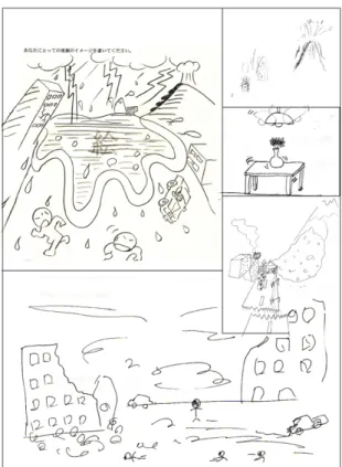
The different consequences of these hazards on human-beings are emphasizes rather than the events themselves. Indeed, the consequences on infrastructures and the human losses represent 48% and 41,1% of the answers in respectively Saikai city and Shimabara city (tab.4). This relation between natural hazards and consequences on infrastructures and inhabitants is also exemplified by the drawings teenagers and adults did (fig. 7).
Answers repartition (%)
Typhoon C.I. (1) Volcano Fire Earthquake Tsunami Flood Others Saikai city 2,1 48 10,4 8,3 8,3 10,4 4,2 8,3
Shimabara city 3,9 41,1 21,5 5,9 3,9 5,9 8 9,8
(1): consequences on infrastructures
Tab. 4: Natural hazards importance for adults and teenagers in Shimabara city and Saikai city.
The importance inhabitants give to natural hazards that drove to risks and sometimes to disaster vary with the age but also the exposure of the queried people. In both studied locations, respondents are emphasizing their own experience compared to other risks or disaster they did not experience themselves, but they got to know through Medias like television, etc. Indeed, in Shimabara city more than 38% of the respondents describe the Unzen eruption as the worse natural disaster of these last 20 years in Japan. Catastrophes
Fig. 7: Examples of natural hazards representation by adults and teenagers at the end of the questionnaires.
like the earthquake in Kobe are coming in second position, even though that last event was far more destructive. Moreover the importance Shimabara inhabitants are giving to the eruption is certainly underestimated because a great number of them migrated after the 1990-1995 eruption. For Saikai city citizen, the Unzen eruption does not have such a great importance, but the overestimation of direct experience has also been observed. If in most cases, the Kobe’s catastrophe is coming out as the worse natural disaster in Japan, the second place is for more than 38% of queried people given to the very important flooding that occurred in the province of Nagasaki in 1981 triggering landslides all over Nagasaki city bringing down houses and changed into a debris flow that ran in the city. Most of adults in Saikai city experienced that event which is called in the Nagasaki province “O-ame”, which means the “big rain”, and they can give very accurate details about the event, like the portion of the littoral road that have been sliding down in the ocean…etc.
Thus, we can observe the importance given to personal experience when it comes to natural hazards perception, and the overvaluation of that experience in regards of other events, known by other mean. This observation was also the same when it comes to the Unzen eruption in Shimabara city.
3.2 Affective and cognitive perception of volcanic risks: a tribute to the
information mean
The Unzen eruption’s pith varies among Shimabara city and Saikai city inhabitants with a logical pre-eminence in Shimabara city. We supposed this difference due to the degree of direct exposure and therefore the mean that
informed population. In Shimabara city, we can conjecture that direct experience has been far-reaching – as expressed previously -, as for Saikai city inhabitants the main information-mean was mass-media network and mainly television. Indeed, the further away interviewed inhabitants are living from a volcano, the lesser importance they give to the eruption, and the greater the media influence (Greene et al., 1981). Thus away from sight of the Unzen volcano, almost all Saikai city respondents have been informed about the eruption through mass-medias – even if 6 respondents declared having news through their family in Shimabara, or through trips around the Unzen. This mass-media information has a direct consequence on the Unzen volcanic hazards perception. Firstly the 1990-1995 eruption perception is very poor in Saikai city, since less than 60% of the respondents knew that the major part of the activity was located towards the East. The respondents in Saikai city also can’t locate on a map the directions of erupted materials. Secondly, Saikai city inhabitants don’t have an accurate perception of the volcanic risks in general. Damages due to ash falls are totally unknown, or forgotten, either on health or on individuals, properties and land. Moreover all the respondents are thinking that even in a case of a major eruption, there is absolutely no risk at about 70km away from the volcano. Saikai respondents are therefore showing a serious lack of knowledge about volcanic risks, even after the Unzen eruption.
On the foot of the volcano, in Shimabara city, the mean of knowledge is obviously different, at least for population who are old enough to have experienced that event. These respondents have direct references in their surrounding landscape, and the answers are accompanied by hands movements showing some places during the interviews. This attitude is not observed at all in
Saikai city. The answers formulated in Saikai city are “dictionary” type of answers. The relations the respondents have with the volcanic hazard lies within the field of intellect and cognition, whereas in Shimabara city respondents are showing a relation which is cognitive and affective. Shimabara inhabitants are bonded in an affective relation with the volcano, and the old and new landscape. The effect of direct exposure to the volcanic hazard is also symbolized in a “reexperiencing” process, even when it comes to project oneself in the future. Indeed, when asked about future disasters that could still happened in Shimabara, lahars in the Mizunashigawa and Nakaogawa are appearing in more than 56% of the answers, a dome collapse in 58% of the answers. If the dome collapse’s risk still exists, there is no real risk of dangerous lahar in the Mizunashigawa or the Nakaogawa. However inhabitants are projecting in the future their own past experience. This reaction was already observed by a query carried on by the Kyushu University in 1995 (Takahashi, 2000). At that time 68,3% of the respondents were afraid of lahars occurring in the Mizunashigawa and Nakaogawa, 35% of a dome collapse, 13,3% of ashfalls. Again, the fear were driven by past-even memory, more than a real estimation of the potential actual danger. The way populations are in contact with a volcanic hazard, through direct experience or through media is influencing the knowledge of the volcanic hazards, the perception of what is dangerous, and also the nature of the link between the human beings and the volcanic hazards: purely cognitive or “affectivo-cognitive”.
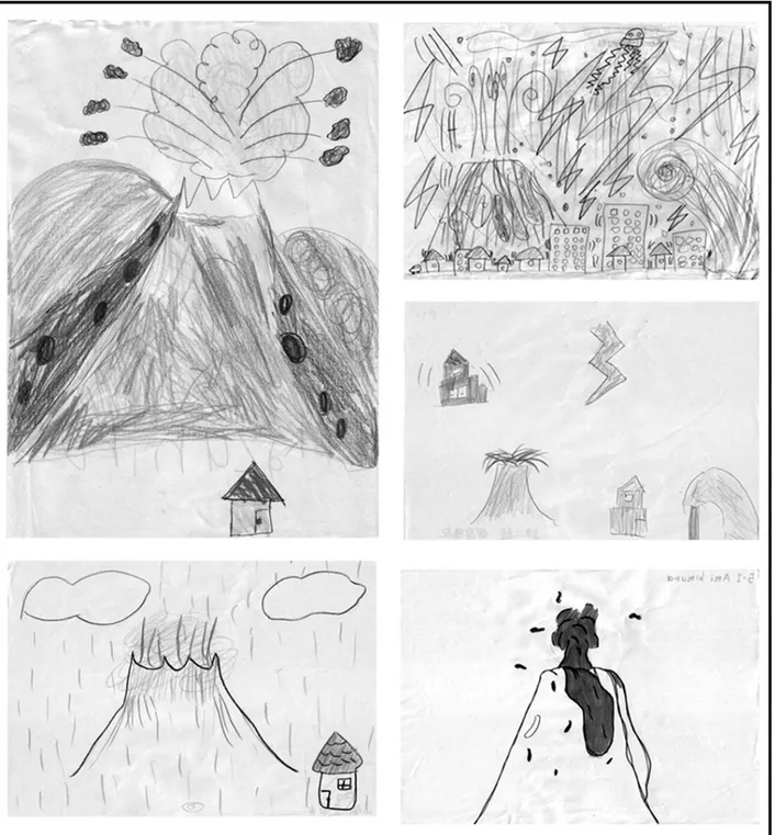
3.3 Volcanic hazards perception among pupils
Volcanoes represented by children are always showing the same pattern of a regular mountain with a truncated summit where a vent takes place (fig. 8). Regarding volcanic hazards developed by 40% of the children in Shimabara city and 24% in Saikai city – other treated of other natural hazards -, the drawings include mostly the following elements: Ashes and clouds coming out the volcanic main vent, lava, explosions, projections, thunder and earthquake linked to volcanic activity. In Shimabara city and in Saikai city, the most drawn phenomenon are the projections flying out of the main vent of the volcano. In Shimabara city 28% of the children drew projections, and in Saikai city 31% did. The other most represented phenomenon are in Shimabara explosions and lava flow with respectively 21% and 14% of the drawings (fig. 9a). In Saikai city, the second and third positions are taken by these same phenomenons however in a different order, with 23% for the lava and a bit more than 15% for the explosions (fig. 9b). Then are coming earthquakes or “ground shake type” due to a volcanic eruption that was represented on a bit more than 18% of the drawings in Shimabara city and 15% in Saikai city. In the End, thunder linked to volcanic activity was represented in 9,3% of the drawings in Shimabara city and 3,8% in Saikai city.
For both locations, elements represented by the pupils are very similar when it comes to volcanic activity. The differences in perceptions observed within the adults don’t seem to exist when it comes to pupils; however the information collection’s mean was different for both adults and pupils groups, therefore it is really difficult to make any comparison. Nevertheless, Shimabara’s pupils have
no personal experience of the 1990-1995 eruption and their volcanic hazards perception is certainly not so different from the one Saikai-city students have.
Fig.9 a,b: Volcanic elements represented by primary school students in Shimabara city and in Saikai city.
4. Discussion and Conclusion
The population in Nagasaki province is showing through this study the different consequences of direct and indirect exposures to natural risks, and thus volcanic
risks. From this degree of exposure, the type of relationship between the natural hazards and the human beings varies. A direct exposure is creating an affective bond between the human being and the hazard. This bond is due to the moral shock that endangered people’s life, or created trauma or post-traumatic stress disorder. This kind of “pathological” relation seems to be expressed by the impossibility to forget the event and an over-emphasis of this one. It is also accompanied by body expressions. Ronan (1998) has characterized a series of psychological disorders in his studies on “benign disasters” that struck children with 65% of reexperiencing, 24% of hyperarousal and 14% of psychic numbing cases. Population can also show clinic psychopatological disorders, but still seems to determine in a post-catastrophe population (Keppel-Benson & Ollendick, 1993, Ronan, 1998) Such cases did not seem to appear during our study, certainly because the respondents were exposed to the eruption about 10 years ago, while the studies dealing with this subject are carried on just a few months after a catastrophe (Eyre, 1998), and also because our respondents were for a greater part of them adults. It seems that the younger the respondents, the more vulnerable they seem to be to post-traumatic stress disorder and psychopathological disorders (Atkins, 1991, Belter et Shannon, 1993, Gibbs, 1989). However it is evident that the relationship between the hazards and the human beings under a direct exposure is totally different from the relationship with indirect exposure. Indeed, the kind speech patterns observed in Shimabara were totally absent from the respondents that have no direct experience of the risks. Thus the information mean linked with the degree of exposure is playing a very important role in risks’ perception, whether it is through a media or through direct experience. Thus more than the distance itself, the degree of exposure to natural hazards seems to be the
key of the psychological bound that links the hazards and the human beings, and then their response to a risk. However, this study can only be considered as a preliminary result on this point, and further studies are needed to be totally affirmative.
The second point brought by this study concerns our hypothesis on pupils’ perception. Indeed the pupils’ perception of natural risks can be differentiated from adults’ perception by the points they are emphasizing. Pupils are emphasizing the natural hazards part of the risks whereas adults emphasized the human consequences. If we only consider volcanic risks pupils are representing the eruption itself – the hazards - whereas adults are representing the buildings destroyed, the inhabitants running away from the danger – the vulnerability. This orientation is the main difference between grown-up and pupils. This representation certainly comes from the absence of death in the elementary school level children; they are still living in an infinite time system where death does not have its place. The second point that differs from the adults is the fact that there is not such a difference between the answers in Shimabara city and Saikai city as it was observed for adults, certainly due to the absence of traumatic experience as we explained before. Even living by the volcano, the absence of direct experience of the eruption erased the differences observed among adults with direct and indirect experience. This is also showing the rapid resilience capacity of a population over natural disasters within only 2 generations, although memory is extremely important following this kind of event as suggested by Hasemi Yuuji (2001).
Thus, if there is no recent eruption, it seems that volcanic hazard perception tends to be quite similar regardless to the distance to the volcano, whereas the
differences could be more important just after an eruption due to the trauma and even psychopathology brought to the directly exposed population. Those trauma and psychopathology are absent from indirectly exposed populations.
Acknowledgments
The Shimabara Town-hall, and the Shimabara branch of the Japanese Ministry of Land and Infrastructures are thanked for their help and the different information provided to complete this study. Junko Yamada has also been of great help on various information collections and their understanding, therefore I would like to especially thank her for her all along help and support.
At last but not least, Gaillard J-C., Dibben C. and two anonymous reviewers are thanked for all the advices they provided and the constructive remarks they made to improve this manuscript.
Bibliography
Akagi, Y., 2001. The tsunami height and damage area of tsunami occurred in Shimabara Peninsula. The Historical Geography 43, 1, 4-19. (in Japanese).
Atkins, F.D., 1991. Children’s perspective of stress and coping: An integrative review. Issues in Mental Health Nursing 12-2, 171-178.
Belter, R.W., Shannon, M.P., 1993. Impact of natural disasters on children and families. In C. F. Saylor (Ed.) Children and disasters. New York: Plenum Press.
Blaikie, P.T., Cannon, T., Davis, I., Wisner, B., 1994. At Risk: Natural Hazards, people’s vulnerability and Disasters. Routledge, London.
Chester D.K., 2005. Theology and disaster studies: The need for dialogue. Journal of Volcanology and Geothermal Research 146, 319-328.
D’Ercole, R., 2006. Volcanic risk perception: comparing public perception maps and scientific hazard maps. Cities on Volcanoes 4, 23-24 January 2006, oral communication.
D’Ercole, R., Rançon J-P., 1994. La Future Eruption de la Montagne Pelée : Risque et Représentations. Mappemonde 4, 31-44.
Dominey-Howes D., Minos-Populos D., 2004. Perceptions of hazard and risk on Santorini. Journal of Volcanology and Geothermal Research 137, 285-310.
Eyre, A., 1998. More than PTSD: Proactive Responses Among Disaster Survivors. The Australian Journal Of Disaster And Trauma Studies 1998-2.
Fujii, T., Setsuya, N., 1999. The 15 September 1991 pyroclastic flows at Unzen volcano (Japan): a flow model associated ash-cloud surges. Journal of Volcanology and Geothermal Research 89, 159-172.
Furuya, T., 1974. A geomorphologic study of the collapse of Mayu-Yama in 1792. Disaster Prevention Research Institute Annual, 17B, 259-264. (in Japanese).
Gaillard J-C., D’Ercole R., Leone F., 2001. Cartography of population vulnerability to volcanic hazards and lahars of Mount Pinatubo (Philippines) : a case study in Pasig-Potrero River basin (province of Pampanga). Géomorphologie: relief, processus, environnement 3, 209-222.
Gibbs, M.S., 1989. Factors in the victim that mediate between disaster and psychopathology : A review. Journal of Traumatic Stress 2-4, 489-514.
Greene, M., Perry, R., Lindell, M., 1981. The March 1980 Eruption of Mount St-Helens, Citizen Perceptions of Volcano Threat. Disasters 51, 1, 46-66.
Gregg, C.E., Houghton B.F., Johnston D.M., Paton D., Swanson D.A., 2004. The perception of volcanic risk in Kona communities from Mauna Loa and Hualaalai volcanoes, Hawaii. Journal of Volcanology and Geothermal Research 130, 179-196.
Hasemi, Y., 2001. Natural disasters happened when we forget about it. K press. (in Japanese)
Hirano, M., 1994. The 1993 lahars and pyroclastic flow on the Unzen Fugendake. The lahars and pyroclastic flows risks on the Fugen Dake, 1-4 (in Japanese)
Hoshizumi, H., Uto, K., Watanabe, K., 1999. Geology and eruptive history of Unzen volcano, Shimabara Peninsula, Kyushu, SW Japan. Journal of Volcanology and Geothermal Research 89, 81-94.
Johnston, D., Benton K., 1998. Volcanic Hazard perceptions in Inglewood, New Zealand. The Australian Journal Of Disasters and Trauma Studies 1998-2.
Johnston, D., Houghton, B., 1995. Secondary School Children Perceptions of Natural Hazards in the Central North Island, New Zealand. New Zealand Journal of Geography April issue, 18-26.
Katayama, N., 1974. Old records of natural phenomena concerning the “Shimabara Catastroph”. Science Report of Shimabara Volcano Observatory 9, 1-53 (in Japanese).
Keppel-Benson, J.M., & Ollendick, T.H., 1993. Posttraumatic stress disorder in children and adolescents. In C.F. Saylor (Ed.) Children and disasters. New York: Plenum Press.
Murton, B.J., Shimabukuro, S., 1974. Human Adjustment to volcanic hazard in Puna District, Hawaii. White G.F. ed., Natural Hazards: local, national, global. Oxford University press, NY, 151-159.
Nakada, S., Shimizu, H., Ohta, K., 1999. Overview of the 1990-1995 eruption at Unzen Volcano. Journal of Volcanology and Geothermal Research 89, 1-22.
Paton, D., Millar, M., Johnston, D., 2001. Community Resilience to Volcanic Hazard Consequences. Natural Hazards 24, 157-2001.
Perry, R.W., Green, M.R., Lindell, M., 1980. Human Response to volcanic eruption: Mt St-Helens, May 18 1980. Batelle Human Affairs Research Center, Seatle.
Ronan, K.R., 1998. The effects of a “Benign” Disaster; Symptoms of Post-traumatic Stress in Children Following a Series of Volcanic Eruptions. The Australian Journal of Disaster and Trauma Studies 1998-2.
Ronan, K.R., Johnston, D.M., Daly, M., Fairley, R., 2001. School Children’s Risk Perceptions and Preparedness: A Hazards Education Survey. The Australian Journal of Disaster and Trauma Studies 2001-1.
Sorenson, J.H., 1981. Emergency response to Mount St-Helens’ eruption: March 20 to April 10, 1980. University of Colorado (Boulder), Institute of Behavioral Science, National Hazard Research Working Paper 43.
Steinberg T., 2000. Acts of Gods: The Unnatural History of Natural Disaster in America. Oxford University Press, New York.
Takahashi, K., 2000. The Unzen eruption hazards plan for the disaster’s recovery. University of Kyushu Press. (in Japanese)
Ui, T., Matsuwo, N., Sumita, M., Fujinawa, A., 1999. Generation of block and ash flows during the 1990-1995 eruption of Unzen volcano, Japan. Journal of Volcanology and Geothermal Research 89, 123-137.
Yoshii, H., 1992. Disaster Warnings and Social Response: The Eruption of Mt. Unzen in Japan. Disaster Management 4, 207-214.