HAL Id: hal-02130387
https://hal.archives-ouvertes.fr/hal-02130387
Submitted on 15 May 2019
HAL is a multi-disciplinary open access
archive for the deposit and dissemination of
sci-entific research documents, whether they are
pub-lished or not. The documents may come from
teaching and research institutions in France or
abroad, or from public or private research centers.
L’archive ouverte pluridisciplinaire HAL, est
destinée au dépôt et à la diffusion de documents
scientifiques de niveau recherche, publiés ou non,
émanant des établissements d’enseignement et de
recherche français ou étrangers, des laboratoires
publics ou privés.
Population Evacuation
Eric Daudé, Kevin Chapuis, Patrick Taillandier, Pierrick Tranouez, Clément
Caron, Alexis Drogoul, Benoit Gaudou, Sebastien Rey-Coyrehourq, Arnaud
Saval, Jean-Daniel Zucker
To cite this version:
Eric Daudé, Kevin Chapuis, Patrick Taillandier, Pierrick Tranouez, Clément Caron, et al.. ESCAPE:
Exploring by Simulation Cities Awareness on Population Evacuation. ISCRAM, May 2019, Valencia,
Spain. �hal-02130387�
ESCAPE: Exploring by Simulation
Cities Awareness on Population
Evacuation
Éric Daudé
CNRS, Normandie University
UMR 6266 IDEES
[email protected]
∗Kevin Chapuis
Sorbonne University, IRD, UMMISCO
USTH, ICTLab, Hanoi
Patrick Taillandier
University of Toulouse
INRA, MIAT
Pierrick Tranouez
University of Rouen Normandie
EA LITIS
Clément Caron
CNRS, Normandie University
UMR 6266 IDEES
Alexis Drogoul
Sorbonne University, IRD, UMMISCO
USTH, ICTLab, Hanoi
Benoit Gaudou
University of Toulouse Capitole, IRIT
Sorbonne University, IRD, UMMISCO
USTH, ICTLab, Hanoi
Sebastien Rey-Coyrehourq
CNRS, Normandie University
UMR 6266 IDEES
Arnaud Saval
University of Rouen Normandie
EA LITIS
Jean-Daniel Zucker
Sorbonne University, IRD, UMMISCO
ABSTRACT
Partial or total horizontal evacuation of populations in urban areas is an important protection measure against a natural or technological risk. However, casualties during massive displacement in a context of stress and in a potentially degraded environment may be high due to non-compliance with instructions, accidents, traffic jams, incivilities, lack of preparation of civil security or increased exposure to hazards. Working in evacuation plans is therefore fundamental in avoiding casualties caused by improvisation and in promoting self-evacuation whenever possible. Since it is impossible to re-create the conditions of a crisis on the ground to assess such evacuation plans, there is a need for realistic models in order to evaluate them using simulations. In this paper, we present the ESCAPE software framework that helps in the development of such plans and testing them. In particular, ESCAPE, which uses the GAMA open-source platform as a core component, provides an agent-based simulation tool that supports simulation of the evacuation of a city’s population at fine temporal and geographical scales. The framework was developed such that it works for a wide range of scenarios, both in terms of hazards, geographical configurations, individual behaviors and crisis management. In order to show its adaptability, two applications are presented, one concerning the evacuation of the city of Rouen (France) in the context of a technological hazard and the other pertaining to the evacuation of the district of Hanoi (Vietnam) in the event of floods.
Keywords
Mass Evacuation, Individual Behavior, Crisis Management, Agent-Based Modelling, Geographical Information System
INTRODUCTION
High concentration of critical infrastructure and decision-making power in increasingly urbanized spaces makes risk and disaster management highly complex (Perrow2007). Population evacuation may be the only effective response to the risk, which generally increases with urbanization rates on the coastlines and in deltas, the presence of factories in areas of high population density, and climate change. Strategy planning therefore becomes a crucial concern, however, its evaluation outside a crisis context is difficult. Indeed, while it is very important to prepare populations and organizations to face such events with the help of exercises or educational programs, there are many aspects that cannot be foreseen, e.g. side effects that prevent people from leaving the area or communicating, or behaviors that cannot easily be anticipated, such as people panicking or not following recommendations. Furthermore, during extreme events, new risks emerge from the actions and interactions between individuals in a potentially hostile (flood, hurricane) and degraded (closed road, broken bridge) environment. All of this can further increase the vulnerability of people who need to be evacuated and the occurrence of incidents: accidents, traffic jams, incivilities, panic situations, lack of preparation for civil security events, increased exposure to hazards... For example, the 55 deaths recorded during the Hurricane Rita in Texas were associated with the evacuation process rather than the storm itself (Knabb et al.2006). Absence of an organization such as an emergency and crisis management authority and lack of a risk culture among the concerned population are thus important factors of territorial vulnerability. Mitigation of risks associated with an evacuation then requires an improvement in the risk culture of populations as well as better operational knowledge among evacuation managers. This must integrate confrontation with potentially unforeseen situations, such as traffic congestion, a broken road section on an evacuation route or the dispatch of contradictory orders by different crisis management players. Drills are usually designed to deal with these requirements (Chalaris et al.2018): these are however difficult to implement, expensive and time-consuming, and they do not allow one to re-create the actual response of individuals to stressful and potentially harmful situations. Computer simulation is taking over, as it relies on increasingly realistic models. The aim is to explore the collective impact of thousands of individual decisions taken in contexts of stress, imperfect information and potentially degraded environment.
Agent-based models (ABM) (Zucker et al.2008) are particularly well-suited for studying how individuals with heterogeneous behaviors in mutual and environmental interaction can influence the overall dynamics of an evacuation partly controlled by an organization. This modeling makes it possible to approach realism in behaviors (capacity of displacement, perception of the environment, objectives) while differentiating the agents (motorists, pedestrians, public transport, civil security). It also makes it possible to integrate geographic data (land use maps, transport networks) and social data (number of inhabitants, road traffic) into the models with a very high level of detail (age, gender, risk culture). This approach enables the researchers to observe the dynamics of the system at various scales, that of the agent or that of the entire system, thus opening up many possibilities in terms of agent granularity. The citizen has local information of the situation, that is to say, the information, which he gets through his senses, enabling him to move or the information, which he gets through his social network, helping him to make a decision. The organization gets broader information on the situation from its sensors in the field (cameras, civil security agents, probes) and can activate its plans. This type of model is also very flexible - it is easy to change a behavior, a spatial attribute or a proportion - and can therefore be used as an artificial laboratory to test many hypotheses (Daudé2008).
This paper presents ESCAPE, an agent-based framework dedicated to the study of mass evacuation strategies of territories under the threat of imminent events due to natural or technical hazards. A preliminary description in figure1shows the main components of ESCAPE: hazards, territorial issues, planning and realization of crisis management that foresees a population evacuation.
With the help of this schematic description of the field of knowledge, this paper aims to propose a conceptual framework and a software architecture (ESCAPE) for mass evacuation using an agent-based model and GIS. It is organized around four main modules:
• the Environment module is related to the spatial and demographic description of the simulation domain. It makes it possible to describe the territory by identifying the main issues exposed in a perimeter of potential danger. These critical issues include the population, transport networks, energy, public institutions;
Figure 1. General diagram of ESCAPE
• the Hazard module makes it possible to describe all the characteristics of a hazard and provides some modeling tools. It enables the integration of various levels of spatialized hazard intensity by geographical information layers, as well as the construction of dynamic propagation models of a hazard;
• the Crisis Management module aims to define available resources which can be used by the organization to operationalize a plan and launch it in phases depending on various scenarios of hazard dynamics.
• the Decision-Making module focuses both on features related to individual mobility, including travel choices, motivations and goals that can be influenced by hazards, as well as on the disaster management authority. We will see that cognitive processes govern agent mobility behaviors as well as the behaviours of organization, whether it is strategic (plan to follow) or tactical (adjust or cope with the unexpected) behavior;
The first section gives an overview of mass evacuation models developed within an agent-based model’s meta-framework. The second section presents the four core blocks of the ESCAPE framework: spatial and demographic data management, hazard dynamics, decision-making behavior and evacuation planning. The third section presents two ongoing applications of ESCAPE: traffic dynamics in Rouen (France) under the threat of industrial accidents and pedestrian evacuation of a district in Hanoi (Vietnam) during a flood event. The results of these applications are discussed in the fourth section that also leaves the door open to further developments.
MODELLING MASS EVACUATIONS
To meet the requirements of planning and crisis management adapted to specific contexts, ESCAPE proposes to develop realistic models, as well as describe the environment, the population and the mobilities in various contexts, from normal to crisis situations. On this point, ESCAPE stands out from most of the existing tools that are oriented towards simulating traffic in normal and mono-modal conditions. We propose tools for multi-modal displacement modeling taking into consideration the agents’ cognitive capacity that allows them to change behavior depending on the context and the means to achieve their objectives.
While well-known traffic frameworks, like MATSim, TRANSIMS, SUMO or SimMobility, make it possible to model day-to-day urban traffic, most of them have limitations when used to study disruption induced by extreme events (Czura et al.2015a). However, several extensions have been proposed in order to adapt these frameworks to the study of mass evacuation: MATSim provides a dedicated extension to study evacuation (Lämmel et al.2009). Several proposals use the template (Kim et al.2017; Zhu et al.2018) for Tsunami and Hurricane evacuation with a simplification in the modelling: pre-computed Origin-Destination (OD) escape trips based on MATSim’s iterative optimization process. Locally, simplification is also seen in terms of a first-in first-out model for micro traffic simulation. The SUMO extension called VEBEN++ has been used to study disruption in traffic due to uncommon events (Flötteröd and Erdmann2018). Unfortunately, as for MATSim, it requires all possible pathways including the evacuation ones to be pre-computed. This is a major issue due to the fact that hazards and social dynamics during the event can have an impact on this environment. For example, one cannot predict that a major road would be blocked during evacuation not because of the flood but because of a major accident. It is this almost impossible to pre-compute all possible pathways given such uncertainties. Moreover, the pedestrians’ walking model is based on dynamics that are very close to those of vehicles and does not reflect the actual people movement in crisis situations (Beck et al.2014): pedestrians move over a network made up of virtual lanes called stripes but can neither use free walking areas nor can they cross roads outside of crossing sections. Several other platforms have been used including AIMSUN (Afzal et al.2017), VISSIM (Harten et al.2018), or Paramics (Chen and Zhan2008) to study
evacuation from a regular traffic simulation platform. These are all based on the study of traffic demand and supply in specific circumstances of evacuation, for example, focusing on traffic mitigation optimization (Harten et al.2018) or evacuation strategy comparison (Chen and Zhan2008).
So, even if agent-based models studying traffic evacuation come in great numbers, there is no dedicated framework to the best of our knowledge (Hawe et al.2012). Furthermore, except for traffic related platforms, agent-based evacuation models often do not incorporate complex transportation systems (Wang et al.2016) nor a smart organization responsible for evacuation management. For the modelling platform, we choose GAMA, an agent-based development framework (Grignard et al.2013; Taillandier et al.2018). It has been used recently to study evacuation and traffic during a catastrophic event (Valette et al.2018; Czura et al.2015a; Adam and Gaudou2017). The platform has several well-suited features such as GIS native integration and simple traffic-related primitives for car (Taillandier2014) as well as pedestrian mobility over both network and continuous topology (Chapuis, Taillandier, Gaudou, et al.2018). This is the framework we choose for the development of ESCAPE.
ESCAPE: AN AGENT-BASED AND GIS FRAMEWORK TO MODEL MASS EVACUATION
The ESCAPE framework is organized around a combination of geographic information systems, agent-based modeling, and simulation exploration methods. Using this framework, we produce a virtual laboratory which allows us to import layers of geographic information describing a territory and its issues with respect to a potential hazard whose intensity is scripted or described using a simulation model. This framework allows us to describe crisis plans based on hazard thresholds and actions to be initiated, as conditioned by available resources. Organizations are then in charge of executing the plan according to a scenario defined either by the user or by the dynamics of the hazard’s model. The main dynamics of the ESCAPE model concern individual agents, who will react, or not, to the perceived, assessed or real dynamics of the hazard. The focus here is on a plan that provides for evacuation, with information that is then disseminated to agents and an environment, especially for evacuation routes, which can be modified accordingly. The framework provides tools for observing and diagnosing evacuation efficacy.
From the modeling of catastrophic events to traffic-related behavior and evacuation/containment plan integration, the framework aims at facilitating the modeling process by integrating modules into a single agent-based modeling solution: all tools have been integrated as one or multiple plugins to the GAMA platform. It includes primitives to manage input data for transportation support, demographics and hazards; various algorithms related to traffic modeling for vehicles, pedestrians, public transport and all the infrastructure; the ability to design evacuation/containment plans and the indicators to assess their quality or make comparisons between them; the Human Machine Interface to create, organize, manage the needed input and the generated output of these evacuation/containment plans. The following sections detail each of the components required in ESCAPE.
Environment Module
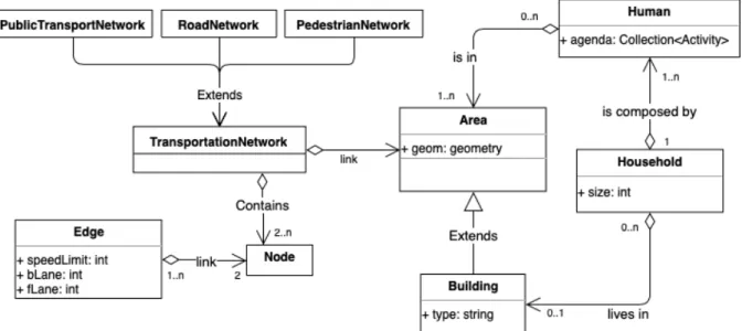
The environment module makes it possible to describe the geographical and social space as well as the daily mobility in the study area. The central concepts are depicted in Figure2using Unified Modeling Language (UML) class diagram: the geographical space is made of Area and Transportation network, while the demographic part comprises a description of Human people, including their daily mobility activity, and the Household they belong to. In ESCAPE, an Area is a spatial object with associated geometry (point, line, polygon, etc.) where people can either walk through, like a park, or cannot cross, like water bodies (e.g. river, lake). Some areas have special features: for example, a building can have a certain number of floors and a capacity of reception if it is a public building. Transportation networks provide the medium for agent mobility. These are made up of edges and node intersections, and can stand for private vehicles, pedestrians or public transport. The last aspect concerns human agents and the households they belong to: Every human agent is endorsed with demographic attributes, like age and gender, and an agenda that describes the purpose and mean of its mobility expectations. Households gather humans in family groups, with an associated role (i.e. parent, child, other) and at least one home place location (i.e. a building). In the following sub-sections, we describe the concepts related to the environment module.
Human and Household: synthetic population generation
Individual characteristics (age, gender, affiliation to one or more social and / or professional networks) have a great impact on mobility behavior (Luo et al.2016) as well as on the response to a crisis situation and evacuation (Bañgate et al.2017). Hence, it is important to have a synthetic population of agents that represents the targeted population accurately. For this purpose, census data constitutes a crucial resource for calibrating the model of the population studied. This data is not systematically available and many countries have only sparse statistics to offer. Regarding ESCAPE, the synthetic population is generated using the Gen* (Chapuis, Taillandier, Misslin, et al.2018) plugin
Figure 2. UML class diagram of the environment module in ESCAPE
for GAMA1, that makes it possible to create individuals grouped into households and to give them attribute values, for example a gender and age for an individual or the number of vehicles and dwelling types for a household. The library provides several well-established algorithms, state of the art synthetic reconstruction and combinatorial optimization techniques (Müller and Axhausen2010) respectively to create or to replicate known individuals and households according to the available data: either micro-data (sample), aggregated data or both. In addition, every household has a default home place to be linked to, i.e. a building as defined in the environment module (see sub–sectionTransportation network and Area), according to customized spatial distribution. Based on the same principle, any individual of the synthetic population can be linked to several spatial objects, like a workplace, a school or a preferred shopping center. For each agent, we can then define a list of all the places that he or she will visit at different moments of the day and on different days of the week. An individual activity space can be defined based on specific studies such as household displacement survey (Czura et al.2015a), social networks (Cebeillac et al.2017) or based on a rough hypothesis such as the relation between age and activity type. Another important issue in the definition of the population and its location lies in taking into account people who do not reside in the area but may be present at the time of an event: this is the case for those present because of tourism, leisure or professional activities. Another aspect which may be important is the determination of the non-autonomous population (isolated, elderly, disabled, hospitalized, imprisoned) which will imply repeated bus trips to evacuate them.
Transportation network and Area: GIS data integration in ESCAPE
Spatial data is also mainly used to set up the simulation environment. Our framework provides an input data structure, with a mandatory and optional setup to design the simulation environment (Grignard et al.2013). It allows us to build basic blocks within the ESCAPE framework: the road network, public transport, walking areas and all the obstacles like buildings and water bodies.
Road network. The road network is the main medium for the traffic model. It can be set up using raw OSM data or custom vector shapefile. Required features include the number of lanes, direction and speed limit for the roads. The road network is composed of roads as edges, defined as polylines, and the nodes depend on OSM’s nodes or the shapefile’s nodes. In our proposal, the network is made up of active road and node agents: roads register users and give them information about speed limit, the number of lanes and the other connected roads. They can also handle traffic dynamics when computer efficiency is a concern, turning into a single agent aggregating all concerned vehicles, by using the same approach as the one presented in (Banos et al.2017). The nodes can be intersections when 3 or more roads are connected to it, bus stop, evacuation or simple node. Intersections have two basic actions: give directions according to vehicle destination and manage traffic signal. The impact of road and intersection agents on traffic dynamics is detailed in sectionHuman agent and mobility.
Public transport. The public transport plugin requires two types of information in order to operate: spatial data and time data. As for the road network, spatial data can be set up using OSM or a shapefile, and consists of a path and a
list of stops, for each transport line. The path is used to control the bus routes, by lowering the weight of roads during Dijkstra computation. Stops are merged into the road network by splitting the closest road, if required, and creating a new node. The time data constitutes the schedule sheets (one for each line), similar to those displayed at bus stops, but in the CSV format. The time data is used to simulate bus departures, and the time they are supposed to be (or wait) at each stop. Here is a sample CSV schedule file:
Stop 1 , 05:53 , 06:10 , 06:34 , 06:44 , 07:02 , 07:07
Stop 2 , 05:58 , | , 06:39 , | , 07:07 , |
Stop 3 , 06:03 , 06:15 , 06:44 , 06:49 , 07:12 , 07:12
In this example, the first bus will be created (or activated if a pool of buses is defined) at the cycle corresponding to 5:53, and should arrive at 5:58 at Stop 2 and at destination Stop 3 at 6:03. The following one starts at 6:10 and goes directly to Stop 3 for 6:15 (| is a skipped stop). We planned to use the GTFS2standard at first, but a flat file is more adapted to our case. We decided to create a script to generate a compatible set of files from a GTFS database. It is however dependent on the data quality, since GTFS is generally not respected perfectly (Kujala et al.2018). Walkable areas. Pedestrian agents are able to walk in specific areas, called walkable areas, following an overprinted virtual pedestrian network: the first one is constructed combining the area with the attribute walkable turnint it into a true and free space, that is the overall studied area minus all obstacles (buildings by default, but can be extended to any spatial object); the second one is inferred from former areas using Delaunay’s triangulation. The algorithm creates nodes on the triangle’s segments that are not in contact with obstacles. Then, one or two links are created between nodes of each triangle in order to create a minimum number of cross-sections, while triangles with only one segment free from obstacle are defined as dead-ends (Chapuis, Taillandier, Gaudou, et al.2018). A combination of the virtual network and walking areas is used for pedestrian traffic movement (see sectionHuman agent and mobility).
Non-walkable areas. Buildings are static spatial entities (polygons) that populate the geographical space of the simulation. Building attributes will be used by individuals to drive strategic goals in the traffic model: localization of the activity places such as workplace, school or home. It is possible to assign a certain number of floors and a refuge function to the building. In the first case and according to the nature of the hazard, a number of floors above a submersion wave, for example, may cause a building to become a vertical evacuation site. In the second case, the shelter is a building open to public and can be used as a confinement site inside the danger zone in the event of an industrial alert. It may also be outside the danger zone, the refuge then being a building previously identified and equipped to shelter a determined number of evacuated people. Non-walking areas also include non-building spatial entities like water bodies.
To summarize, this first environment module provides tools to give a detailed description of (i) the geographical area (elevation, road-network, building, walkable area, water body), and (ii) the population present on the territory at the time of the decision to evacuate, or the triggering of the hazard. Each agent can be defined on the basis of demographic characteristics, be attached to a family unit, can be autonomous or not in terms of mobility, be associated with a place of residence that can be outside the simulation zone and have a list of places he or she visits, regularly or otherwise. As this data is used to instantiate the initial population, one can define other attributes which may be of interest to simulate individual behaviors. These attributes may represent knowledge about risk and security instructions as well as emotional factors. All these attributes could be used by cognitive tools that take the thought-processes, decisions and reactions (see sectionAgent cognition) into account. The next paragraph presents the second module dedicated to hazard description.
Hazard Module
ESCAPE Framework features hazard modeling library tools that enable simulation of disastrous events with increasing complexity: from static spatial objects to dynamic agents. The simplest way to model such type of events is to define a static object to be triggered at a certain time and/or space during the simulation. This object can represent the possible impact zone related to a Seveso accident (see sectionIndustrial hazard case study). Each object, whether static or dynamic, has attributes that serve to qualify its potential impact on the issues, i.e. the environment, the human agents and / or the organization. These attributes can be a water level and speed associated with a spatial footprint, a lethal effect for agents present in the zone or the blocking of roads in the perimeter subject to the extension zone of the hazard. It is possible to produce scenarios for the evolution of a hazard, in the form, for example, of nested zones whose transition from one to another in time and in space is based on past events (for
example, a flood) or a hypothetical scenario which mimics the growth of the spatial area representing the event. Modelers can provide as many extension zones describing the spatio-temporal dynamics of the hazard as necessary. These objects and the transition scenario from one to the other can then be used as indicators for triggering a warning system and a crisis management plan (see sectionCrisis Management).
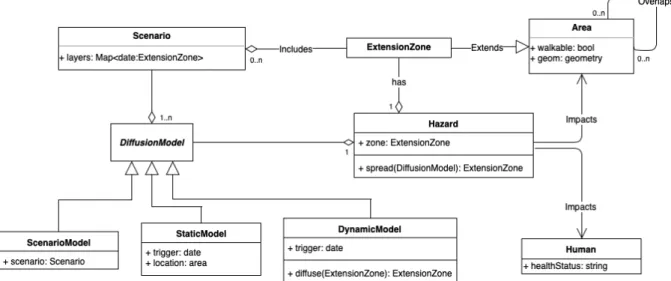
Figure 3. The UML class diagram of ESCAPE hazard module
Another way to represent the evolution of a hazard or danger consists in generating a catastrophic event using dynamic diffusion rules. We provide two methodologies to generate this kind of events: extension over cells of a cellular–automata or moving geometries over a continuous space. The first one consists in splitting the spatial area of study into cells of equal size, e.g. 20 x 20 meter square that cover the overall studied area, and mimic the evolution of the event by the diffusion of properties and values from cell to cell. For example, one cell can be on fire and diffuses fire to adjacent cells following a diffusion equation that can include any process, like direction of wind or the amount of combustible. The initial distribution of the variable to be diffused can be easily set up using GIS data. The second option is close to the scenario-based representation of a hazardous event: starting from an extension zone, e.g. shapefile of a river or the footprint of a building on fire, the spatial object representing the catastrophe can be extended using agent-based spreading rules. In this extension, each vertex of the hazard spatial object is an agent that will apply the spreading rules: for example, a flood spatial object could have vertices speed up by decreasing or slowing down with increasing elevation, stopped by obstacles such as buildings, or splitting up when reaching a threshold distance between them. Generative solutions can be useful in two cases: when data is missing or when one wants to explore several catastrophic developments from a base scenario.
To summarize, this second Hazard module makes it possible to develop an ESCAPE scenario in a specific zone with really crude data, for example, only one shapefile giving a specific zone to evacuate in order to define the best evacuation roads and evaluate the delay of evacuation. In this case, one can assume no interactions with the hazard, which is in many cases the aim of preventive evacuations. One can also import several layers representing the spatial and temporal dynamics of the hazard. In this case, ESCAPE provides tools to configure the delay between each layer in order to simulate the speed of the event. Finally one can choose to model the hazard dynamics with CA or moving geometry. This last possibility is interesting in case there is no information about the possible spatial extent of a hazard or if one has only its maximum extension value.
The realism of the simulations thus requires, for these two previous modules, a precise description of the territories concerned by the hazards and their stakes. The use of a geographic information system makes it possible to structure this data. This realism also involves a detailed description of the population to be evacuated. With the use of agent-based modeling, each agent is differentiated according to several criteria: gender, age, family composition ... Each agent will also have a perception and representation of his environment, and will be able to act accordingly, which we will see later in this paper. Before that, the next section presents the third most important module in ESCAPE which allows the description of means implemented by public and private actors to make the territories less vulnerable to these hazards. In particular, it insists on crisis management and its strategic and operational aspects.
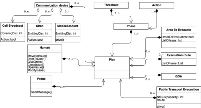
Figure 4. The UML class diagram of ESCAPE evacuation plan module
Crisis Management Module
Whenever an evacuation is required, whether it must be accomplished urgently (Tsunami) or spread over time (cyclone), the objectives are the same: How does one alert the people? By what means can we get as many people out of this geographical area as possible in the shortest possible time? How to organize bus routes so that they cover the widest possible area and collect the largest number of people? How to offset population departures in order to limit network congestion? How to deal with people who are not residents and who are not familiar with the evacuation procedures? The possibility of describing an evacuation plan or confinement strategy with ESCAPE is then a crucial issue. It must be a means to evaluate existing evacuation plans depending on factors such as the number of casualties or the time of complete evacuation.
On the basis of spatiotemporal hazard scenarios identified hereinabove, emergency planning zones can be defined and measures for the protection of the population worked out by the different authorities. Evacuation plan description can be schematically split into two categories, one related to available resources, both material and immaterial, and one related to the phases, i.e. the different stages of use of these resources according to the evolution of the hazard and of the plan itself (see figure4).
Available resources
Planning involves deploying along a scale, (hazard intensity-based, time-based or alert-based) divided into a finite number of phases, a series of actions that mobilize resources to accomplish a program. Our framework provides optional setup to design available resources, i.e. but one can simulate self-evacuation of people to explore the overall effect of a lack of strategy. A certain number of human resources, probes, buses or shelters are all resources which can be used in a plan to conduct an evacuation.
Checkpoints and probes in the territories. Observation of an evolving hazard in a territory is an essential factor to start an action plan as soon as possible and to make it evolve during an event. Probes are agents placed in the environment to record specific attributes, such as the water level or wind speed. We can locally use these probes to follow the evolution of a hazard described from a dynamic model. We can also use these probes to follow traffic congestion, as does video surveillance, for example. This information can be provided to the organization, automatically or on demand, to trigger or to decide the type of actions to be taken.
Communication device. Evacuation implies alerting and keeping the people informed during an event. Various tools are implemented in ESCAPE to simulate information diffusion. Alerts can be transmitted through a network of sirens. In this case one can define location of these sirens and the distance covered by the microphone which is supposed to transmit the signal to the agents. Alerts and information can also be sent using radios or mobile devices, in this case the spatial dimension is less important than the individual equipment level and connection to
social networks which can be defined during the initialization process. Alerts and information can then be given to the entire population (siren, radio) or to sub-groups (cell broadcast principle).
Areas to be evacuated. The determination of the areas to be evacuated makes it possible to estimate the number of people who will have to be evacuated, independently or assisted by public transport. As for the environment definition, these areas to evacuate can be defined using a shapefile. Identification of these areas makes it possible to estimate whether it is necessary to carry out a poly-phased evacuation, by focusing at first on the evacuation of the people present in the most exposed zones. The choice between a simultaneous evacuation or an evacuation in phases can be then made on the basis of information related to hazard scenarios (differentiated levels of the hazard in the area, temporal dynamics of the hazard) or of a geographical division depending on criteria such as maximum population densities, building types, road network constraints etc. It finally helps to identify evacuation routes that minimize the risk of congestion. When an evacuation concerns many neighborhoods, care is taken, for example, to avoid the flow of vehicles crossing or converging towards the same exit point.
Gathering and orientation areas. Provisional shelters are places for hosting evacuees who do not have accommodation, such as family or friends. Each hosting site has a limited human capacity which must be known in order to allocate the population in the various shelters. For people with their own accommodation solution, orientation zones are targets that must be reached quickly during evacuation to exit the danger zone. These are most often roundabouts, motorway entrances or commercial areas that the most important roads converge to, thus facilitating the evacuation. From there, the vehicles disperse to reach various destinations outside the danger zone. The existence of these assembly points is generally accompanied by evacuation routes, a sub-section of the road network that the motorists will have to use, depending on their location, in order to leave the zone. These routes may be more or less adapted to the evacuation, with certain routes closed to traffic or traffic direction changed on others.
Public Transport Evacuation Plan. Public transportation is a resource deployed to collect non-autonomous people (children, elderly) and more generally anyone who does not have a means of transport to take them to the shelter or the orientation zone. We need to define pick-up points (bus stop) inside the zone for evacuation to shelters outside the area. Resources involved in terms of buses required and pick-up points depend on the proportion of non-autonomous population as defined in sectionHuman and Householdand their residence place. During the evacuation, the schedule file and normal routes are no longer adapted. Instead, we use evacuation routes (Noria), with pick-up and evacuation points and a pool of buses.
Human resource. Execution of a plan involves deploying human resources on the ground which will be able to secure danger-prone areas, install signposts on the ground, inform and help people during the evacuation process. ESCAPE provides two different methods to take such resources into account. The first one is to create agents in order to perform specific actions. These actions will then be limited by the number of agents available and their capacities to carry them out. Methods such as door-to-door information dissemination or road closure are available to these agents. The other option is to declare a value of available agents per hour and to compute, for every action taken in a given place, the necessary time to accomplish it and counting down the credit time.
After quoting the various resources available to the crisis manager, the following section details the use of these resources before and during the crisis.
Phase specification
The perception of an event (rising water level) can lead to an action (close) on a target (a road). Planning is about connecting perceptions with actions and targets in order to achieve a set of goals. These sets perception-action-targets can be broken down into various phases, from a vigilance phase to an alert one. A plan can then be described with the help of general semantics allowing each alert level to define perceptions that will trigger actions to be executed on a set of targets during the simulation. The overall plan is then supervised by one or more organizations that will be able to allocate resources for its execution.
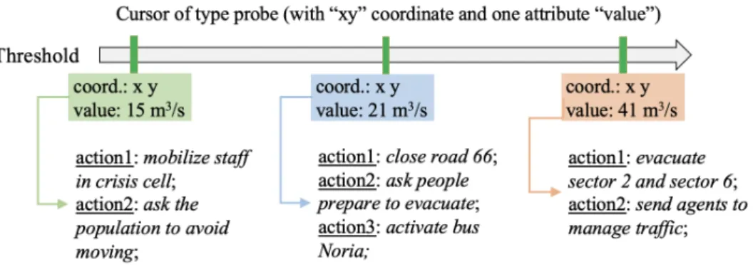
Steps or phases of a plan. The phases of a plan relate to the pre-crisis, crisis and post-crisis periods. ESCAPE offers tools to model the first two phases, only the first one (preventive evacuation) or the second one (emergency evacuation). The procedures that allow the continuation of certain activities even in a degraded situation and the planning of the return of the populations are for the moment outside the scope of ESCAPE. From a time scale or threshold scale, the user can define as many phases that exist in a specific plan or create a new plan from scratch. It is possible to associate the time or threshold scale to a series of objects which will be used to both describe the hazard dynamics as well as engage in new protocols. The position of each object along the axis defines the time (or threshold) of its activation. These objects can represent probes (level of water), polygons (spread of flood), time (before event) or information (weather warning). The user, by changing the slider position on the scale, can decide the moment or the intensity at which the phase is switched on or off. Objects on this scale will then define the
Figure 5. an example of scale of evolution of the hazard allowing to graduate the actions to lead
phases, such as vigilance, pre-alert and alert phases. Once the various phases are defined, it is necessary to define actions that can be taken for each of them (5).
Actions in a plan. An action, for example the closing of a bridge, is triggered by an organization either through direct access to the object concerned (here a link of the road network) or performed by an agent which must then have capabilities (perception, mobility, cognition etc.) to act on this object. An action can have a limited life, which must be defined in terms of phase, time or threshold. It can also have an unlimited life, which implies that once a phase is triggered, the initiated actions continue to be realized even if the thresholds progress and engage additional actions related to the subsequent phases. Many actions can be performed following the triggering of a phase. If initially these actions concern essentially the diffusion of information to the population and the agents involved in the plan, concrete actions such as closing of the schools or activation of Noria buses can follow. Gathering information on the evolution of a hazard or population dynamics is an action that can be performed throughout the simulation. Information can be collected either locally via probes or agents or globally via counters. Information here represents the mediated perception of an event. The second type of flow of information is related to information transmission. Resources such as communication devices can be used to transmit information to agents or other organizations. This information coming from the organization are inputs for other agents, whether it is individual agents of the population or organization agents (civil servants). The semantic content of sent messages is important because it will act on the action performed by the receiver. But a plan is not just about information flow but also about concrete actions. The main actions to be carried out in the implementation of an evacuation plan are possible here. Sending personnel to a specific area, closing / opening an object (e.g. a road section), modifying the attributes of an object (e.g. traffic light), triggering the dispatch of messages. The execution of most of these actions involves the use of the agents’ elementary behaviors as described in figure6.
After defining the risks in a given territory, the resources available and the strategies that can be implemented to protect populations, the last section describes the intelligence of the ESCAPE system.
Decision-Making Module
This cognitive module deals with individual aspects for perception, displacement, decision making or emotions related to citizens or civil servants and with organizational aspects for operationalization of the plans, adaptation to event dynamics and for optimization scenarios.
Agent cognition toward mobility behavior
Individual and collective response to unpredictable and potentially threatening circumstances due to a hazard event are difficult to observe and reproduce. However, there is a broad consensus on the complexity of human behavior during such an episode (Toledo et al.2018). Hence, we want the agents of our framework to be able to mimic those responses and exhibit complex decision-making processes and behaviors. Our proposal extends the BDI model of cognition (Bratman1987) to include emotional response and social attachment to better apprehend individual and collective dynamics during evacuation.
Enhanced Belief-Desire-Intentions architecture. In order to enable such complex human behaviors, ESCAPE allows the use of BEN (Behavior with Emotions and Norms) agent architecture (Bourgais et al.2017). BEN is based on the BDI model of cognition that features modules for adding emotions, emotional contagion, personality, social relations and norms to agent behavior. It was already used to model human behaviors in two evacuation contexts: bush fire evacuation in Australia (Adam, Taillandier, et al.2017) and the evacuation of the Station Night Club in the US (Valette et al.2018). The use of BEN for ESCAPE enables not only taking into account the capacity of the
Figure 6. The UML class diagram of ESCAPE Human agent module
agents to carry out complex plans (e.g. choosing sub-objectives from a set of antagonist desires such as going to school to pick up their children and going as far as possible from the hazard area), but also the impact of emotions (and their contagion) and norms (laws, social norms) on the agent behavior. Not only can BEN be used to model the transition between normal behavior and evacuation behavior, using the knowledge of the disaster or danger signal, but the addition of norms, emotions and social relations also makes it possible to specify heterogeneous responses: for example, will drivers follow driving rules while feeling in danger or will parents go to the designated shelter while their children are at school? Moreover, the architecture is flexible enough to endorse normal as well as crisis behavior and decision-making circumstances. In addition to these cognitive aspects, the agent has skills related to its mobility.
Strategical, Tactical and Operational level. ESCAPE promotes an activity-based macro traffic dynamics using data-driven synthetic agenda to cope with the strategic level. Each individual of the synthetic population is generated with a scheduled set of activities according to its demographic attributes and optional data about mobility activities (see sectionHuman and Household). Thus, the overall traffic demand is generated from the bottom-up, emerging from the agenda of individual users. The tactical level is more concerned with how the agent will cope with the direct environment in order to reach its destination. Using the BDI architecture coupled with emotions and social constraints (i.e. norms and social relationships) makes it possible to respond in a credible manner to unexpected traffic-related circumstances: for example, will they follow driving rules or will emotions and desires lead them to disregard them. The operational level is agentified using multi–modal algorithms to handle traffic related micro,
e.g. lane change or collision avoidance, to nano dynamics, e.g. time frame speed regulations and continuous pedestrian walking direction. In the subsequent paragraphs, we will give details of the tactical and operational levels of pedestrian and motorized mobility behavior.
Human agent and mobility
Agent mobility includes pedestrian and motorized trips using private or public transport vehicles6. Agents mostly follow a synthetic activity agenda as the main plan which is supposed to replicate daily mobility. In an emergency situation, depending on its perception by agents and the knowledge about safety measures, they can switch off more or less rapidly their synthetic agenda - they change their plans - to follow other targets: go back home, pick up children at school, reach an evacuation center ... and implement new means to achieve them: new trip, new modes of transport, all of this with a more or less strong emotional charge.
Pedestrian mobility model. Pedestrian mobility is a mix between free movement in a continuous space and a constrained path defined on a specific pedestrian network (Chapuis, Taillandier, Gaudou, et al.2018). These interlacing dynamics make it possible to define the shortest path on a dedicated network and micro dynamics of continuous movement. On the tactical level, agents estimate the shortest path on the dedicated pedestrian virtual network, and, on the operational level, move over a continuous space following a series of nodes as intermediary goals. Each edge is then considered as a segment that occupied all the available space defined in the walking area, pedestrians going in and out as is the case in 1D road networks. Agents will avoid collision with other agents inside segments following a repulsion mechanism inspired by the social force model (SFM) (Helbing and Molnar
1995). Enhancements from the classical physical inspired model include behavioral and collective adaptation: the probability of agents getting back to a previous position when its current move inside a segment is blocked by other pedestrians and the collective speed adaptation negatively correlated (with threshold values) to the number of other users within the segment.
Vehicle mobility model. This model basically concerns motorized modes of transport, from individual to collective ones. The main idea is to dedicate a tactical level for i.e. path finding, re-routing and response to environmental change and to dedicate an operational level to e.g. lane change, speed or collision avoidance. The main processes of vehicle micro and nano dynamics are comprised within a skill, a set of methods (behavior) and variables (attributes) automatically associated to a kind of agent within the GAMA platform. This skill makes it possible for any vehicle (private car, bus) in ESCAPE to: manage moving speed, lane change, overtaking and distance from other users according to driving rules, road attributes and willingness of the driver. For more details on algorithms and processes involved in vehicle behavior, see Taillandier2014and Czura et al.2015a. Note that both the use of personal vehicles and moving buses on a dedicated network as described inTransportation network and Areause the same library.
Evacuation behavior. While an agent will follow the agenda for day–to–day trips, e.g. go to work or go shopping, any hazard related event (siren, SMS, rumor etc.) can disrupt this normal course of action. In this transition stage, humans rarely remain fixed in one type of behavior but instead have a series of behavioral reactions, according a continuum between instinctive reactions such as stupefaction, panic, automaton behavior or instinctive struggle (Goya2014) to reasoned reactions such as following the rules (confinement, evacuation), following the social norms (altruism) or individual rationality (pick the children up from school, fight against the potential impact of the danger). Deviant behaviors such as looting and curiosity can be ranked in this latter category (Cantin et al.2016). In Escape, we then consider evacuation behavior as a different version of the agent’s normal mobility behavior. The normal mobility behavior is then written in each agenda and each agent uses strategies and tactical behavior to follow this agenda. With hazard dynamics and / or the evacuation signal, agents may trigger another strategy. So, despite the danger, a certain part of the population will temporarily follow their every day life: this happens frequently in flood risk territory where, despite an alert level asking people to stay at home, the residents do not trust these authority signals and continue their normal activity, thus potentially endangering themselves (Ruin et al.
2017). On the contrary, others can react automatically to the event and the signal but do not follow any rule or advice given by the competent authorities: they will stay locked up at home instead of evacuating for example, or the opposite. Finally a proportion of people will both react in a timely manner to their own safety and follow the instructions that are given. It is the spatio-temporal conjunction of these three types of behavior that makes evacuation complex and which requires that it be organized and controlled.
Organization agent
Evacuation of hundreds of thousands of people is often based on an organization controlled by only a few dozen experts and guided on the ground by hundreds of agents. Human issues are therefore essential for the success of an evacuation, because people are expected to follow actions planned by experts, and organizations must be ready to adapt to people reactions and behaviors if dynamics fall outside the framework it has set. We make a distinction between and individual, as depicted previously with the citizens, and an organization. In the first category we also add those responsible for evacuation (civil servants: police, firefighters, civil defense, etc.). The second category represents an entity which aims to use resources in order to execute an evacuation plan as defined inCrisis Management. It is possible that an evacuation concerns several organizations if several plans exist. This may be so in the case of a major crisis spreading over a very large geographical area that involves several municipalities. In this case, one main organization can control the others with a specific plan and can collect and diffuse information about possible contradictions between actions taken by these different organizations. The behavior of an organization is then to use the information collected on the “ground” through control points and from other organizations to coordinate the evacuation plan. One can say that evacuation from the organization’s point of view is a top-down approach.
The last section presents two case studies still undergoing active development. The aim of these two examples is to give some details about data processing, methods implemented and model evaluation.
ESCAPE CASE STUDIES
The first example shows the use of the driving skill in the context of the evacuation of a city with automobiles, the second one focuses on the evacuation of a district by pedestrians, access to motorized vehicles being impossible. Geographic data of these two case studies is loaded to define graphs from polyline geometries and polygons with related attributes (i.e. building, park, school ...).
Industrial accident in the French city of Rouen
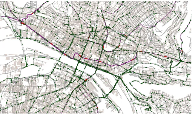
Rouen is a Norman city (France) built across the river Seine, with six bridges over it. This topology makes its road network vulnerable to events that would damage or more generally reduce access to the bridges. Many SEVESO plants are installed along the banks of the river, most in reach of at least one bridge: industrial hazards are a preeminent risk for the city. The official instructions in the case of an industrial accident is the confinement of people, at home or in the nearest building. But if an event occurs during the day, tens of thousands of motorists or people on public transport may have to leave the dangerous area as quickly as possible due to lack of available shelter. How long can it take at best? Are the bridges that divide the city into two a real challenge for spontaneous evacuation? We built Rouen’s road network with OSM data and chose to define as orientation zones all the nodes located at the border of the simulation space. These orientation zones represent targets that must be reached by drivers to evacuate the zone at risk. Bus lines and bus stop times are taken directly from the public site of the agglomeration’s transport authority. Each stop is thus associated with a node in the graph and whenever necessary, in particular for the exclusive use of bus lanes, certain sections have been identified as being authorized for the buses only.
Figure 7. ESCAPE Rouen. Road network and buildings from OSM, with car (in green) and buses (in red)
Localization of the population is an important issue for this type of unpredictable hazard because it greatly affects its vulnerability. We have chosen as the initial condition the worst situation, that is to say, during the peak traffic time in the morning on a weekday. The volume of cars in circulation and their location on the network was estimated from the city’s traffic count data. The driver’s agenda was defined from the household and displacement survey, which indicates all the movements of a population sample for a typical day. Each agent localized in the network has an agenda indicating the places he must successively go to. Being in one place, he will implement different behaviors (tactical, strategical and operational as described in (Czura et al.2015b)) to reach his next destination. The definition of the plan has only two phases here, since it goes from a normal circulation phase (Tranouez et al.
and change their destination whatever be their agenda. For each of them, the new destination becomes the closest exit point of the network in terms of reaching time. Figure7shows a part of the simulation space. We can clearly see, in the center of the image, the 6 bridges that connect the right and the left banks of the city. Unsurprisingly, the city center with its 5 bridges is the longest to evacuate. According to initial conditions and parameters used (Czura et al.2015b), it takes almost an hour and a half to evacuate most of the 42 000 vehicles present initially.
In these simulations, buses had the exclusive use of their dedicated lines and we did not simulate traffic accidents. The constraints on the use of the network can easily be relaxed by introducing in the plan, the use of a new network layer adapted to the evacuation, in which the bus lanes can be used by all vehicles, with possibly a change in the direction of circulation to promote centrifugal movements. The capacity of the model to allow integration or emergence of accident-prone situations is more complicated because of the several factors that may be involved in a traffic accident. For the moment, the mobility model corresponds to that of an autonomous car, capable of making rational decisions concerning its own objective (to reach a point as quickly as possible) while adapting itself to the behaviors of the other cars present in its environment. One might be tempted to use accident statistics on the territory to inject accident probabilities at certain accident-prone points. But we cannot be certain that it would be the same areas concerned and the same behaviors that would cause accidents during a crisis and evacuation situation.
Flood risk in a small quarter of Hanoi city
According to the world risk index, Vietnam is one of the 20 most vulnerable countries around the world with respect to natural disasters. The country’s long coastline (covering more than 3400 km), the two major deltas (Red river and Mekong) and low altitude (only 20% of level land cover) make recurrent storm and typhoons deadly. On November 2017, Ho Chi Minh City authorities decided to evacuate by anticipation 2 million people because of the typhoon Damrey, nonetheless, causing at least 30 deaths. Management and control of such extreme and large events are a priority challenge for Vietnam’s authorities.
Figure 8. ESCAPE in Phuc Xa quarter in Hanoi. Evacuation model (Chapuis, Taillandier, Gaudou, et al.2018) with both vehicle (in blue) and pedestrian (in green)
A previous study applied our framework to the small ward of Phuc Xa in Hanoi, the capital city of Vietnam (Chapuis, Taillandier, Gaudou, et al.2018). It covers 1km2between the Old Quarter of Hanoi separated by a Dike and the Red River. The simulated scenario has been built in anticipation of a possible failure of the Hoa Binh dam, situated more than 80km upstream of Hanoi. The failure would cause a wave of water to submerge a large portion of the city, including Phuc Xa neighbourhood. Because of the lack of data, the hazard was not directly implemented into the simulation model. Rather, we chose to trigger dispatch of an evacuation signal to all the individuals of the studied population, urging them to evacuate the area towards the closest exit. Regarding the synthetic population of agents, we recreated the record population from available census of 2009: 15767 people with known age and gender. Regarding mobility behavior, we implemented a basic every-day-life synthetic agenda as a proof of concept. Agents leave their home place to go to another building in the area at any random time between 8 and 10am. The target building represents either a known localized workplace and school for an active adult agent and under-18 agents respectively. A third kind of mobility, which mostly consists in wandering around, was implemented for retired
people. For mobility modes, we emphasize two-wheel vehicles and pedestrian mobility behavior. Agents will choose to use one or the other depending on the estimated travel time, without any consideration on whether they are moving towards everyday objectives or evacuation exits.
Much attention has been given to the micro-level mobility model: pedestrian movement is explicitly represented with avoidance of collision and walking over a continuous space, while two-wheel vehicles follow the rules defined in the previous study in the city of Rouen (see sectionsHuman agent and mobilityandIndustrial hazard case study). For the former, the initial setup was defined using shapefiles of buildings and free walking areas. We applied Delaunay’s triangulation algorithm to divide the whole space into small sections that allows pedestrian agents to find their way through the entire ward, while walking towards intermediary target points as is the case in a network.
Figure 9. Small section of the ward with (a) walking area detection using buildings (b) Delaunay’s triangulation process resulting in a scattered walking area (c) the final pedestrian virtual network to guide people walking through the area
As depicted in figures 9, defining the virtual network, in which the agents find their way to walk towards the destination, is a three-step process: (a) defining the walking area using any obstacle, in our case all the buildings (b) dividing the whole area into small sections to be used (c) eliciting the virtual network. Like vehicles, the agent will then be able to search for the shortest path from the starting point to the pedestrian destination using the network. The evacuation signal is sent early in the morning at 8.00 am, with mobility behavior starting at 7.30 am. This means that some agents will be at home and others moving towards their goals as they walk or drive to their workplace, school or just wandering around. Thus, the evacuation starts while people are already in the middle of their daily activities. Considering this basic setup, we have been able to estimate the time of evacuation for the overall area to be about 1 hour 37 minutes. However, because of lack of data, we have not been able to apply any kind of mitigation strategy, nor different scenarios considering the impact of the hazard on the evacuation process.
CONCLUSION AND FUTURE WORKS
This paper is about a new multi agent-based simulation framework named ESCAPE, which aims to support a wide range of population evacuations in urbanized territories. As such, ESCAPE can clearly be categorized as a decision-making tool. It can take into account both the fine geographic scale, e.g. nano-scale traffic and continuous movement as well as the fine time scale, e.g. second-to second speed regulation. It is built upon the GAMA environment and organized around four main modules:
• the Environment module deals with the spatial and demographic description of the simulation domain; • the Hazard module describes all the characteristics of catastrophic events and the associated impact on
human agents and infrastructures;
• the Decision-Making module focuses on the behavior and cognitive processes of people affected by the hazards and organizations attempting to manage the evacuation;
• the Crisis management module provides available resources and plan to guide and coordinate human and organizational agent responses;
The framework already integrates dedicated tools to provide modelers an easy-to-use environment to simulate evacuation in urbanized areas. However, the integration process is still a work-in-progress and we plan to release the first beta version in 2019. As shown in previous case studies, at the current stage, the framework makes it possible to simulate the evacuation of a city using multi–modal traffic model. The next phase will be to implement evacuation plans and organization to manage them, in order to simulate evacuation strategies. This will take the form of how-to and what-if scenario. Indeed, one essential aspect of studying evacuation through simulation is the possibility of testing several strategies and assess how they succeed and compare the output. To this end, we propose several default indicators like time of evacuation and the number of exposed agents. But our perspective is to give modelers tools to build their own indicators, so that they can adapt what success is and how they can asses it to the type of hazard (and exposure), the kind of safe area or any other evacuation circumstances. A typical What-if? scenario in ESCAPE is to replay the same simulation and then to disrupt an element, either of the plan (no activation of an action) or of the environment (faulty probe or blocking of a section). An optimization scenario How-to? in ESCAPE can calculate routes that minimize the evacuation time of a group of people located in different areas to gathering and regrouping areas. The classical Dijkstra algorithm can be used as a preliminary approximation in order to build an evacuation plan, which will then be evaluated through simulations.
Acknowledgment This work is funded by the ANR ESCAPE project, grant ANR-16-CE39-0011-01 of the French Agence Nationale de la Recherche and by the MADNESS project, grant HN0002110 of the Normandie Region and European Union (FEDER).
REFERENCES
Adam, C. and Gaudou, B. (2017). “Modelling Human Behaviours in Disasters from Interviews: Application to Melbourne Bushfires”. In: Journal of Artificial Societies and Social Simulation 20.3, p. 12.
Adam, C., Taillandier, P., Dugdale, J., and Gaudou, B. (2017). “BDI vs FSM Agents in Social Simulations for Raising Awareness in Disasters: A Case Study in Melbourne Bushfires”. In: International Journal of Information
Systems for Crisis Response and Management (IJISCRAM)9.1, pp. 27–44.
Afzal, M., Ranjitkar, P., Costello, S. B., Jayananthan, N., and Jayasinghe, S. (2017). “Emergency Evacuation Modelling using Traffic Simulation: A Case Study of Auckland”. en. In: p. 13.
Bañgate, J., Dugdale, J., Adam, C., and Beck, E. (2017). “A review on the influence of social attachment on human mobility during crises”. In: ISCRAM, Albi.
Banos, A., Corson, N., Lang, C., Marilleau, N., and Taillandier, P. (2017). “Multiscale modeling: Application to traffic flow”. In: Agent-based Spatial Simulation with NetLogo, Volume 2. Elsevier, pp. 37–62.
Beck, E., Dugdale, J., Truong, H. V., Adam, C., and Colbeau-Justin, L. (2014). “Crisis Mobility of Pedestrians: From Survey to Modelling, Lessons from Lebanon and Argentina”. en. In: ISCRAM-Med. LNBIP. Springer, Cham, pp. 57–70.
Bourgais, M., Taillandier, P., and Vercouter, L. (2017). “Enhancing the behavior of agents in social simulations with emotions and social relations”. In: International Workshop on Multi-Agent Systems and Agent-Based Simulation. Springer, pp. 89–104.
Bratman, M. (1987). “Intentions, plans, and practical reason.” In: Harvard Univ. Press.
Cantin, G., Verdière, N., Lanza, V., Aziz-Alaoui, M. A., Charrier, R., Bertelle, C., Provitolo, D., and Dubos-Paillard, E. (2016). “Mathematical Modeling of Human Behaviors During Catastrophic Events: Stability and Bifurcations”. In: I. J. Bifurcation and Chaos 26.10, pp. 1–20.
Cebeillac, A., Daudé, É., and Huraux, T. (2017). “Where ? When ? And how often ? What can we learn about daily urban mobilities from Twitter data and Google POIs in Bangkok (Thailand) and which perspectives for dengue studies ?” en. In: Netcom 31-3/4, pp. 283–308.
Chalaris, M., Emmanouloudis, D., and Wen, J.-C. (2018). Novel approaches in risk, crisis and disaster management. Natural Di. Nova Science Pub, p. 428.
Chapuis, K., Taillandier, P., Gaudou, B., Drogoul, A., and Daude, E. (2018). “A multi-modal urban traffic agent-based framework to study individual response to catastrophic events”. en. In: The 21st International Conference on
Principles and Practice of Multi-Agent Systems (PRIMA2018), p. 8.
Chapuis, K., Taillandier, P., Misslin, R., and Drogoul, A. (2018). “Gen*: a generic toolkit to generate spatially explicit synthetic populations”. In: International Journal of Geographical Information Science 32.6, pp. 1194–1210.
Chen, X. and Zhan, F. B. (2008). “Agent-based modelling and simulation of urban evacuation: relative effectiveness of simultaneous and staged evacuation strategies”. en. In: Journal of the Operational Research Society 59.1, pp. 25–33.
Czura, G., Taillandier, P., Tranouez, P., and Daudé, É. (2015a). “MOSAIIC: City-Level Agent-Based Traffic Simulation Adapted to Emergency Situations”. In: Proceedings of the International Conference on Social
Modeling and Simulation, plus Econophysics Colloquium 2014. Ed. by H. Takayasu, N. Ito, I. Noda, and M. Takayasu. Cham: Springer International Publishing, pp. 265–274.
Czura, G., Taillandier, P., Tranouez, P., and Daudé, É. (2015b). “MOSAIIC: City-Level Agent-Based Traffic Simulation Adapted to Emergency Situations”. In: Proceedings of the International Conference on Social
Modeling and Simulation, plus Econophysics Colloquium. Ed. by Springer. Proceedings in Complexity. Chap. 24, pp. 265–274.
Daudé, É. (2008). “Multi-agent systems for simulation in Geography: Moving towards an artificial Geography”. In:
The modeling process in Geography: From determinism to complexity. Ed. by Y. Guermond. ISTE&WILEY. London: GIS Series. Chap. 13, pp. 309–329.
Daudé, É., Tranouez, P., and Langlois, P. (2009). “A multiagent urban traffic simulation. Part II: dealing with the extraordinary”. In: Internation Conference on Complex Systems and Applications, pp. 1–5.
Flötteröd, Y.-P. and Erdmann, J. (2018). “Dynamic Reroute Modeling for Emergency Evacuation: Case Study of Brunswick City, Germany”. In: Int. Journal of Mechanical, Aerospace, Industrial, Mechatronic and Manufacturing
Engineering12.4, pp. 99–109.
Goya, M. (2014). Sous le feu: la mort comme hypothèse de travail. Tallandier.
Grignard, A., Taillandier, P., Gaudou, B., Vo, D. A., Huynh, N. Q., and Drogoul, A. (2013). “GAMA 1.6: Advancing the Art of Complex Agent-Based Modeling and Simulation”. In: PRIMA 2013. Ed. by G. Boella, E. Elkind, B. T. R. Savarimuthu, F. Dignum, and M. K. Purvis. Berlin, Heidelberg: Springer Berlin Heidelberg, pp. 117–131. Harten, E., Patel, R., Ryan, L., Sawyer, J., Barbera, J., Mazzuchi, T., and Santos, J. (2018). “Evaluation of traffic
mitigation strategies for pre-hurricane emergency evacuations”. en. In: 2018 Systems and Information Engineering
Design Symposium (SIEDS). Charlottesville, VA: IEEE, pp. 214–219.
Hawe, G. I., Coates, G., Wilson, D. T., and Crouch, R. S. (2012). “Agent-based simulation for large-scale emergency response: A survey of usage and implementation”. en. In: ACM Computing Surveys 45.1, pp. 1–51.
Helbing, D. and Molnar, P. (1995). “Social Force Model for Pedestrian Dynamics”. In: Physical Review E 51.5, pp. 4282–4286.
Kim, J., Lee, S., and Lee, S. (2017). “An evacuation route choice model based on multi-agent simulation in order to prepare Tsunami disasters”. In: Transportmetrica B: Transport Dynamics 5.4, pp. 385–401.
Knabb, R., Brown, D., and Rhome, J. (2006). Tropical Cyclone Report: Hurricane Rita 18-26 sept. 2005. Tech. rep. 1. National Hurricane Center, pp. 1–33.
Kujala, R., Weckström, C., Darst, R. K., Mladenović, M. N., and Saramäki, J. (2018). “A collection of public transport network data sets for 25 cities”. In: Scientific data 5, p. 180089.
Lämmel, G., Klügl, F., and Nagel, K. (2009). “The MATSim Network Flow Model for Traffic Simulation Adapted to Large-Scale Emergency Egress and an Application to the Evacuation of the Indonesian City of Padang in Case of a Tsunami Warning”. en. In: Pedestrian behavior: models, data collection and applications. Ed. by H. Timmermans. 1. ed. Bingley: Emerald.
Luo, F., Cao, G., Mulligan, K., and Li, X. (2016). “Explore spatiotemporal and demographic characteristics of human mobility via Twitter: A case study of Chicago”. en. In: Applied Geography 70, pp. 11–25.
Müller, K. and Axhausen, K. W. (2010). Population synthesis for microsimulation: State of the art. ETH Zürich, Institut für Verkehrsplanung, Transporttechnik, Strassen-und Eisenbahnbau (IVT).
Perrow, C. (2007). The Next Catastrophe: Reducing Our Vulnerabilities to Natural, Industrial, and Terrorist
Disasters. Princeton University Press.
Ruin, I., Lutoff, C., and Shabou, S. (2017). “Anticipating or Coping: Behaviors in the Face of Flash Floods”. In:
Floods, pp. 259–275.
Taillandier, P. (2014). “Traffic simulation with the GAMA platform”. In: International Workshop on Agents in
Taillandier, P., Gaudou, B., Grignard, A., Huynh, Q.-N., Marilleau, N., Caillou, P., Philippon, D., and Drogoul, A. (2018). “Building, composing and experimenting complex spatial models with the GAMA platform”. In:
GeoInformatica.
Toledo, T., Marom, I., Grimberg, E., and Bekhor, S. (2018). “Analysis of evacuation behavior in a wildfire event”. In: International Journal of Disaster Risk Reduction.
Tranouez, P., Langlois, P., and Daudé, É. (2009). “A multiagent urban traffic simulation. Part I: dealing with the ordinary”. In: Internation Conference on Complex Systems and Applications, pp. 297–302.
Valette, M., Gaudou, B., Longin, D., and Taillandier, P. (2018). “Modeling a Real-Case Situation of Egress Using BDI Agents with Emotions and Social Skills”. In: International Conference on Principles and Practice of
Multi-Agent Systems. Springer, pp. 3–18.
Wang, H., Mostafizi, A., Cramer, L. A., Cox, D., and Park, H. (2016). “An agent-based model of a multimodal near-field tsunami evacuation: Decision-making and life safety”. en. In: Transportation Research Part C: Emerging
Technologies64, pp. 86–100.
Zhu, Y., Xie, K., Ozbay, K., and Yang, H. (2018). “Hurricane Evacuation Modeling Using Behavior Models and Scenario-Driven Agent-based Simulations”. en. In: Procedia Computer Science 130, pp. 836–843.
Zucker, J.-D., Drogoul, A., and Treuil, J.-P. (2008). Modélisation et simulation à base d’agents. Ed. by Dunod, p. 352.