C E N T R E D'E T U D E S E T D E R E C H E R C H E S S U R L E D E V E L O P P E M E N T I N T E R N A T I O N A L
SÉRIE ÉTUDES ET DOCUMENTS
PES Impact and Leakages over Several Cohorts: The Case of PSA-H in
Yucatan, Mexico
Gwenolé Le Velly
Alexandre Sauquet
Sergio Cortina-Villar
Études et Documents n° 29
November 2015
To cite this document:
Le Velly G., Sauquet A., Cortina-Villar S. (2015) “PES Impact and Leakages over Several Cohorts:
The Case of PSA-H in Yucatan, Mexico”, Études et Documents, n° 29, CERDI.
http://cerdi.org/production/show/id/1759/type_production_id/1
CERDI
65 BD. F. MITTERRAND
63000 CLERMONT FERRAND – FRANCE
TEL.+33473177400
2
The authors
Gwenolé Le Velly
PhD in Economics
CERDI – Clermont Université, Université d’Auvergne, UMR CNRS 6587, 63009
Clermont-Ferrand, France.
Email :
gwenole.le_velly1@udamail.fr
Alexandre Sauquet
PhD in Economics
University of Ottawa, Department of Economics, Faculty of Social Sciences, 120 University,
Ottawa, Ontario, Canada, K1N 6N5.
Email :
asauquet@uottawa.ca
Sergio Cortina-Villar
PhD in Geography
El Colegio de la Frontera Sur (ECOSUR), Department of Agriculture, Society and Environment,
Carretera Panamericana y Periferico Sur s/n Barrio Maria Auxiliadora, San Cristobal de Las
Casas, Chiapas, CP 29290, México.
Email :
scortina@ecosur.mx
Corresponding author: Gwenolé Le Velly
This work was supported by the LABEX IDGM+ (ANR-10-LABX-14-01) within the program “Investissements d’Avenir” operated by the French National Research Agency (ANR).
Études et Documents are available online at:
http://www.cerdi.org/ed
Director of Publication: Vianney Dequiedt
Editor: Catherine Araujo Bonjean
Publisher: Mariannick Cornec
ISSN: 2114 - 7957
Disclaimer:
Études et Documents is a working papers series. Working Papers are not refereed, they constitute
research in progress. Responsibility for the contents and opinions expressed in the working papers rests solely with the authors. Comments and suggestions are welcome and should be addressed to the authors.
3
Abstract
We assess the impact of a payment for environmental services scheme implemented in
Mexico, the PSA-H, over the 2005-2012 period. By studying several cohorts of program
beneficiaries we are able to shed lights on the permanence of the program's impact. Based
on the exploitation of 2.5 to 20m resolution SPOT images and ejido-surveys carried out in 76
ejidos located in the Cono Sur of Yucatan, we find that the program's effects are cancelled
after communities choose to withdraw from the program, as well as evidence of leakages.
We discuss these results from a policy perspective.
Key words
Payments for Environmental Services ; Environmental Policies ; Impact Evaluation ; Leakages
JEL codes
Q23; Q28
Acknowledgment
This research is part of the PESMIX project, funded by the French national funder Agence
Nationale de la Recherche (Convention 2009- STRA-008.01), part of the 2009 Systerra call for
research proposals. The authors acknowledge Jennifer Alix-Garcia, Catherine
Araujo-Bonjean, Kathy Bailys, Chloé Duvivier, Gaspard Dumollard, Céline Dutilly, Don Fullerton,
Antoine Leblois, Serge Garcia, Sébastien Roussel and Julie Subervie for valuable comments
on earlier versions of this article, as well as Olivier Santoni for technical support. The authors
also thank all the participants of the seminars at University of Illinois at Urbana Champaign,
the Laboratory of Economic Forestry, and the University of Wisconsin at Madison, and
participants at the 3
rdInternational Conference on Environment and Natural Resource
Management in Developing and Transition Countries, 2014, the 21
stEAERE annual
conference, 2015, the 32
ndJournée de Microéconomie Appliquée, 2015, and the 55
thannual
meeting of the Société Canadienne d'Economie, 2015.
1. Introduction
Payments for environmental services’ (PES) schemes constitute an instrument of increasing interest to address deforestation issues in developing countries. Compared to other environmen-tal policy instruments, the novelty of PES is to offer payments conditional on a desired outcome, for instance conservation of the forest cover (Ferraro and Kiss, 2002; Karsenty and Ezzine de Blas,2014; Wunder, 2015). They are considered as direct approaches to environmental issues that have the potential to mobilize resources for forest conservation. During the last years, they became very popular among decision makers and are now considered as favored instruments for the redistribution of funds destined to protect worldwide forests (UNEP et al.,2008;Muradian et al.,2013). However, as highlighted by (Martin Persson and Alp´ızar,2013), the conditionality does not guarantee that the schemes generate addtionality if the beneficiaries had complied with the conditionality without payments.
Since the seminal “Money for Nothing” from Ferraro and Pattanayak (2006), the lack of studies on PES impact evaluation has been well documented (Pattanayak et al., 2010;Miteva et al.,2012;Ferraro and Hanauer,2014;Baylis et al.,2015), and part of the challenge is taken by recent empirical works (Alix-Garcia et al.,2012;Arriagada et al.,2012;Robalino and Pfaff,2013;
Costedoat et al., 2015, among others). Yet, while a few careful impact evaluations now exist, a new challenge arises: treated to be analyzed are no longer the first cohort of beneficiaries. They potentially exited the program during the studied period, or might have delayed their entry. It poses new challenges but also allows to get insights on the permanence (whether the program impact persists after beneficiaries withdraw from the program) of such programs. We thus intend to contribute to the literature by examining a PES program impact on several cohorts. We focus on the implementation of a federal Mexican hydrological PES (the PSA-H) in the Yucatan state, over the 2005-2012 period. We compare the impact of the program on each cohort of treated and thus provide insights on the permanence of the impact. Such investigation cannot be led without providing an overall evaluation of the program effectiveness, that is to say, its additionality (avoided deforestation on protected parcels) minus potential leakages (impact of the program on deforestation in neighboring lands). It leads us to implement an empirical strategy in order to estimate the three kinds of impact of a program on deforestation: additionality, leakages, and permanence.
When leading the empirical analysis, based on remote sensing analysis using 2.5 to 20m resolution SPOT images and ejido-surveys carried out in 76 ejidos located in the Cono Sur of Yucatan, we tackle several challenges. First, the unit of analysis used differs from the literature: we combine land tenure, land use, and gridding, to obtain an homogenenous unit of analysis and create various variables measuring deforestation determinants. It allows us to improve selection on observable (compare to studies at the municipality-level or even parcel-level), while carefully taking into account property rights and decision power. Second, we use spatial econometrics tools to measure two kinds of leakages (activity-shifting and market effects). Finally, we take into account entry/exit phenomenon over the studied period. We think discussions on choices made may reveal useful for other studies on the topic, while our empirical results are important from a policy design perspective.
The next section presents a short literature review on PES Impact Evaluation (IE). Section
3 presents our study area and the program implementation. Section 4 is dedicated to the presentation of our empirical strategy while our main results are discussed in Section 5. We present various robustness checks in Section 6, before concluding the paper in Section7.
2. Evaluating PES impact
In the recent years, a growing body of empirical works looking at PES impact has emerged (Alix-Garcia et al., 2012; Arriagada et al., 2012; Robalino and Pfaff, 2013, among others). This literature relies on existing IE methodologies developed in other fields of economics such as microfinance, health economics and education (Ravallion, 2007). Evaluating PES impact requires reconstituting a counterfactual in order to evaluate the additionality of the program, i.e. the avoided deforestation on protected parcels. However it also requires taking into account leakages that may undermine the additionality of the program. We sketch out the literature on PES additionality and leakages and explain how our investigation is related to it.
2.1. Estimating avoided deforestation
Evaluating additionality means to estimate the difference in outcome for a given parcel with the program and without the program. Thus it requires to define a proper counterfactual (Ferraro,2009). Simple before and after or with and without comparisons are likely to be biased (Joppa and Pfaff,2009,2010). In econometric terms, there are confounding factors that affect
both the PES reception and deforestation itself. In the context of PES, many confounding factors are geographic variables, including the percentage of forest cover as well as important determinants of deforestation such as population density, slope and elevation and distances to roads, cities and agricultural fields (Angelsen and Kaimowitz, 1999;Pfaff et al., 2009; Honey-roses et al.,2011).
To minimize potential biases, researchers usually choose a control group in the same agro-ecological area as the beneficiaries (Arriagada et al.,2012, among others). Additional unobserv-able confounding factors are household characteristics that affect the deforestation rates and willingness to enter a PES scheme. On that matter, Alix-Garcia et al.(2012) propose using as a control group, applicants rejected for budget insufficiency. In our own study, first we restrain the analysis to the South of the Yucatan State (homogeneity in agro-ecological characteristics), and second, we drop non applicants from our sample, in order to control for the willingness to join the PES scheme (unobserved heterogeneity).
To control for observed heterogeneity among treated and control groups, most empirical anal-ysis relies on matching methods such as PSM (Robalino and Pfaff,2013) or covariate matching (Arriagada et al.,2012). A notable exception is the study byAlix-Garcia et al.(2012) in Mexico that uses matching as a preprocess in order to select a relevant control group and estimates the program’s impact in a regression framework. We explain why we adopt this last strategy in Section4.2.1
PES impact studies also differ according to the choice of the unit of observation. Some authors looks at deforestation of pixels (Pfaff et al., 2009) while others compute deforestation per forest owners (Arriagada et al.,2012). Honey-roses et al.(2011) proposes building polygons by overlapping pixels of land cover, land tenure and protection by natural protected areas. In this paper, we combine Honey-Roses et al.’s approach with gridding. It allows us to improve selection on observable, while keeping the entire sample in the analysis, as explained in Section
4.1.
Note that most studies conclude that the impact of PES on deforestation is low. They attribute this finding to weak capacity of schemes to focus on threatened forest (seePattanayak
1Note that in the context of protected areas, other estimators have been used, see e.g. Sims(2010) andAndam
et al. (2010) that used two-stage least squares estimator in Thailand and Costa Rica, andCanavire-Bacarreza and Hanauer(2013) who used genetic matching in Bolivia.
et al.,2010, for a good literature review).
2.2. Estimating leakage effects
For carbon sequestration projects, leakage is defined by the International Panel on Climate Change (IPCC) as “the indirect impact that a targeted land use, land-use change and forestry activity in a certain place at a certain time has on carbon storage at another place or time” (Watson et al., 2000). This definition, while simple, can encompass a wide variety of mech-anisms. An important distinction is made between activity-shifting and market effects2 (Wu,
2000;Schwarze et al.,2002, among others).
As explained by Schwarze et al. (2002), activity-shifting is “the displacement of an activity outside of the project’s boundaries”. Let us consider the example of a landowner clearing forest to extract timber or to cultivate a commodity. He may shift his activities to another area following the implementation of the PES scheme3. In forest conservation PES programs, if land
is easily available, this type of leakage is very likely to undermine the project’s additionality. Leakages may even be larger than the positive effect of the project if the project relaxes a credit constraint (Jayachandran, 2013). A solution to enhance permanence and reduce leakages is to provide alternative livelihoods options as highlighted by (Aukland et al.,2003). It requires combining PES with investment in order to relax dependence on the forest cover (Pirard et al.,
2010;Karsenty,2011). However, this solution might prove costly and most PES schemes do not include such feature.
Market effects occur if an environmental project such as a PES affects the prices of the commodities. If conservation decreases the supply of the commodities, the price of these com-modities may increase which generates an incentive for additional deforestation. This leakage effect through prices is the most cited in the literature (Wu,2000;Wu et al.,2001) but conserva-tion programs can have other indirect effects. For instance, let us consider a project proposing alternative livelihoods options as in the Integrated Conservation and Development Projects (ICDPs): if these options are very attractive, the project may generate an influx of population and increases deforestation (Aukland et al.,2003). In our case, we expect that an indirect effects
2
This distinction is often made in the academic literature, sometimes under different terminology (eg: primary, direct or substitution effects vs secondary, indirect or output price effects).
3
Note that in most cases, the beneficiary of the projet is the agent shifting activities but leakages can also result from the behaviour of another agent.
might arise through the agricultural markets. As a matter of fact, following conservation in one parcel, the neighbours may face more demand for their agricultural products which increases deforestation in the neighbouring area.
Leakages are important determinant of PES effectiveness (Wunder, 2008; Delacote et al.,
2015). Two approaches are used in the literature to evaluate the extent of leakages. The first approach estimates a baseline of deforestation based on a theoretical model (Geres and Michaelowa,2002;Chomitz,2002;Murray et al.,2004;Sohngen and Brown,2004). The second approach uses econometrics and impact analysis tools. Our methodology derives from this second approach. In the context of Brazilian Protected Areas (PA), Amin et al. (2014) use instrumental variables and spatially interrelated cross-sectional equations to take into account the fact that PA are not randomly created. The authors provide evidence that the decisions to deforest of neighbouring municipalities are complements, and that PA generates leakages (in the sense that they shift deforestation activities to neighboring municipalities). To evaluate leakage effects,Alix-Garcia et al.(2012) compare deforestation occurring in an untreated parcel located in the same ejido than a treated parcel, compare to deforestation in a similar parcel, located in the same ejido than a parcel which applied to the program but was rejected for budget insufficiency. Honey-roses et al. (2011) compare coefficients’ magnitude of the impact of the PES with and without bordering parcels included in the control group. They infer the leakages effects in the border area from this difference. We here propose evaluating leakages using spatial econometrics tools, and simultaneously estimate avoided deforestation and leakages in a regression framework.
3. Context 3.1. The PSA-H
The PSA-H is a Mexican federal PES program that has offered payments for forest conser-vation since 2003 (Mu˜noz-Pi˜na et al.,2008). It is a hydrological PES scheme that focuses on overexploited aquifers and is partially funded by a water tax. Contrary to the other federal PES scheme, the PSA-CABSA, the PSA-H does not remunerate reforestation and agro-forestry (Corbera et al.,2009).
Around 80% of the Mexican forest are owned by small communities called ejidos and most of the forest cover is managed as commons (Bray et al.,2003). This land tenure system results
from agrarian reforms implemented over the 20th century in Mexico, and makes Mexican PES programs specific. Indeed PES contract are concluded with ejidos, not with individuals. Within the ejidos, each member, called ejidatario, has an equal vote at the assembly. Decisions related to the commons such as land clearing are discussed at the assembly. Enrolling land into a PSA-H requires an agreement at the assembly. The ejidos do not necessarily enroll all of their forest into the PSA-H. Once enroled, the ejido receives payments proportionally to the number of hectares enrolled. Contracts last for five years and guarantee yearly payments. After five years, the ejido can apply again to renew the contract on the same parcel. It can also cumulate contracts over time in different areas of the ejido. Payments received can be invested in public goods or redistributed among ejidatarios (Garc´ıa-Amado et al.,2011).
3.2. The Cono Sur
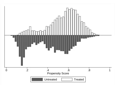
Ejido-surveys were conducted in the 76 ejidos of the Cono Sur, a region covering the south-ern part of the Mexican Yucatan state (see Figure 1). The 76 surveyed ejidos constitute an exhaustive sample of all the ejidos that were eligible for PSA-H reception in 2012 in the re-gion. In this sample, more than 60% of the households are involved in agricultural activities or cattle-ranching. The main crop cultivated is maize intercropped with beans mostly for self-consumption (only around 15% of households sell a share of the harvest). Many households combine these activities with off-farm work. Most communities are remote from the main mar-kets (on average 35 km or more than 50min). Among these ejidos, 40 participated in the program for at least one year by 2013. Most of the non-beneficiaries are located in the northern part of Cono Sur and had just been eligible for a few years. FollowingAlix-Garcia et al.(2012), we kept only the 22 non-beneficiary ejidos that had already applied to the program to control for the willingness to join the program. Among those 22 ejidos, 16 entered the program in the two next years. On average, rejected applicants were accepted into the program two years after their first application. Our final sample is composed of 62 ejidos. Figure2 displays the initial enrollment date into the PSA-H.
Figure 1: The Cono Sur of Yucatan
Figure 3presents the evolution of eligibility zones in the Cono Sur between 2004 and 2012. Eligibility zones have been enlarged over time. Eligibility of an area is decided at the federal level by CONAFOR but regional offices can suggest including new areas. According to CONAFOR’s regional staff, the northern area became eligible later than the southern area because information concerning the forest cover loss in the area was not available and funds were insufficient at the federal level to cover off all the Cono Sur.
Figure 3: Eligibility between 2004 and 2012 in Cono Sur
(a) 2004 (b) 2008 (c) 2012
4. Empirical strategy
The aim of this section is to propose a rigorous empirical strategy for the evaluation of the PSA-H in Yucatan. First, we propose building polygons by combining gridding, land use, land tenure and PES reception. Second, we propose a regression framework and use pre-matching to account for the selection bias. Third, we explicitly introduce leakages in our estimation using spatial econometrics. Fourth, we introduce the time spent in the program and heterogeneity in the enrollment date, which allows us to get insights on the permanence of the program’s impact.
4.1. Combining gridding, land tenure, and PES reception
To analyse deforestation in the Cono Sur region, we relied on 2.5, 10 and 20m resolution SPOT images for 2005 and 2012. The remote sensing analysis was based on ground-truthing data and participatory mapping. The defined classification allows us to distinguish between forests, agricultural fields (including pasture), and, roads and infrastructure. The relevant zones to be analyzed, and included in the empirical analysis are the forested area in 2005 and 2012 (see e.g. Figure4a). Other land use classes are used to build control variables, as explained through this section.
Figure 4: Definition of the unit of analysis
(a) Forest cover (b) Forest cover and gridding
(c) Forest cover, gridding, and ejidos’ borders
(d) Forest cover, gridding, ejidos’ borders, and PSA-H in 2010
blablal
Legend: Forest cover is in dark green while the absence of color correspond to all other land uses. Grid’s length is 500m. Ejidos’ borders are marked by a thick yellow line and PSA-H covered areas (2010 cohort) are
signaled by hatched zones. All maps are oriented North.
The remote sensing analysis provides us with information at the pixel level. Nevertheless, in the current investigation, a grid-level analysis is preferred to a pixel-level analysis. It decreases measurement errors and allows us to keep the entire sample in the empirical analysis.4 We
choose to use a grid of 500 meters which provides us with 25-hectare cells, or approximately the average size of a crop field in the studied area. We apply a gridding on the satellite images,
4An alternative approach would have been to randomly select pixels in our 20 million pixel-level observations
sample. Yet, a risk of non-representative selection would have remained and it would have complicated the analysis of leakages.
as shown in Figure 4b. If a cell is not entirely covered by forest, we redefine its boundary, and keep only the forested part for our analysis. Furthermore, explaining the deforestation level of a cell spreading over two ejidos would not be relevant since the decision to deforest does not belong to the same group of individual for each part of the cell. Consequently, we merged the gridding with ejidos borders (see Figure 4c). Two separate observations are created for each transboundary cell.
The next important information to integrate is the protection status of each parcel. We merged our GIS database with borders of the PSA-H contracts defined by the CONAFOR. As described in the previous section, an ejido can receive a program several times. For instance a parcel covered by the program during the 2004-2009 period can be renewed and receive the program during the 2009-2013 period or not. By merging PES borders with our GIS database, we are able to tell for which period of time a parcel was treated. Obviously, if only half a grid is covered by the program (Figure 4d), the observation is, once again, split in two.5 The final polygons are slightly heterogeneous in size but homogeneous in terms of the program status (i.e. protected or not), number of years of reception, and land tenure (belong to the same ejido).
Eventually, by overlapping forest polygons of 2005 and 2012, we compute the percentage of forest loss within each polygon during the first years of the PSA-H implementation. For each polygon of forest, we also use information on other land cover classes to compute geographic variables such as distances to the village, roads and agricultural fields, elevation, slope and spatially lagged variables. We complete these data with information at ejido-level from the ejido-survey conducted in December 2012. This allows us to improve our identification strategy, partly based on selection on observables, as explained in the next section.
We drop polygons of less than 0.5 hectares since they mainly result from misoverlap of the original PSA-H polygons. These observations represent less than 1% of our study area. Our final sample is composed of 10,352 forested polygons. The final polygons are , on average, 170 polygons per ejido. In our study area, forest covered more than 174,000 hectares in 2005. Around 77,000 hectares have been enrolled in the PSA-H at various points in time between 2005 and 2013. In this period, 7,900 ha of forest have been lost which corresponds to more than 4.7%
5
By extension, when several PES contract overlap - e.g. a parcel is protected by a 2005-2009 contract and a 2010-2014 contract - observation boundaries are redefined such as each parcel is covered by forests protected during the exact same period.
of the total forest cover in 2005.
4.2. Identifying the impact of the program
To identify the impact of the program, we decided to focus on an homogeneous agro-ecological region, the Cono Sur. In addition, we excluded non applicants to the program from the studied sample in order to control for the willingness to join the PES scheme. Finally, we implement a pre-matching procedure and study the impact of the program through a regression framework, as described in the following sections.
4.2.1. Pre-matching: Dealing with selection
About 43% of the polygons in our sample receive the PSA-H. As there are confounding factors impacting both deforestation and reception of the program, we must take into account the selection process in order to correct the bias. We propose to estimate the probability to receive the program (propensity score), and to use the predicted probability in two ways. First, we use a matching procedure based on propensity scores to select our sample. Second we introduce the propensity score as a control variables in our regressions. This strategy is similar toAlix-Garcia et al.(2012) and Alix-Garcia et al.(2015).
A regression framework is preferred to a matching estimator for two reasons. First, it allows us to directly estimate leakage effects through spatially lagged variables. Second, contrary to usual IE techniques, we use a continuous treatment to take into consideration the time spent in the program, as explained in the subsequent sections.
We estimate the following model for propensity scores:
pscoreij = P r(psaij = 1) = θ + K X k=1 τkXkj+ L X l=1 ψlZlij + µij (1)
The probability that a polygon received the PSA-H between 2005 and 2012 (psaij = 1),
depends on the decision of the ejido j to join the PSA-H and the choice of the ejido to enroll polygon i rather than another. For this reason we include variables at the ejido Xj and
polygon-level Zij.
At the ejido-level, the set of K control variables X includes the size of the ejido in thousands of hectares and the number of ejidatarios per hectare (the variables Size of the ejido and Population density). We also control for two major PSA-H selection criteria likely to influence
deforestation: the marginality index computed by CONAPO in 2005 (Marginality index ), and the deforestation risk index (Deforestation risk ) (Mu˜noz-Pi˜na et al.,2008).6
The set of L control variables Z at the polygon level includes the size of the polygon in 2005 (the variable Polygon size), the average slope (Average slope), and distances to the nearest road and agricultural field or pasture within the ejidos in 20057, as well as the distance to the
nearest city of more than 2,500 inhabitants in km (the variables Distance to road, Distance to agri., and, Distance to city). We control for the number of years of eligibility (Nb. of years since eligible) and the conditional probability that the polygon received the PSA-H (Pscore) as explained in Section4.2. Variables definitions and sources, as well as basic descriptive statistics can be found in Table9 and 10of the Appendix.
Based on the distribution of the propensity scores for treated and control groups, we restrict our sample to the common support. Moreover, for each treated observation, we keep in our sample the first nearest neighbor in terms of propensity score with replacement. Through this process, we ensure that our control group is similar to our treated group. In order to take into account heterogeneity of propensity scores, we introduce the propensity score as a control variable in our estimation.
4.2.2. Estimating additionality
After this final sample selection, we are ready to estimate the impact of the program. We estimate, via OLS, an equation of the following form:
defij = α + β1psaij+ β2P scoreij+ K X k=1 γkXkj+ L X l=1 φlZlij + εij (2)
The dependent variable, defij, is defined as: defij =
(f orest05
ij−f orest12ij) f orest05
ij
. It is the percentage of forest cover loss between 2005 and 2012, where f orest05ij (f orest12ij) is the forested area in hectares in 2005 (2012) of polygon i located in ejido j.8 The variable psa takes the value of
6
The marginality index marginality index based on measures of education, infrastructures or access to energy, among others, while the deforestation risk index is an indicator generated by the Instituto Nacional de Ecologia using regression analysis of deforestation patterns in the period 1994-2000.
7Note that, if we had not considered land tenure in the definition of the unit of analysis, it would have been
impossible to compute these important confounding factors.
8Remark that since we restrict our analysis to areas covered by forest in 2005, the variable defij does not
capture forest regeneration but only deforestation within each forested polygon. This definition is consistent with the conservation objective of the PSA-H. Comparing forested areas under conservation with areas in regeneration may bias our results since PSA-H areas are, by definition, already entirely covered by forest.
one if the polygon is covered by the program between 2005 and 2012. The variable P scoreij is
the probability to receive the program between 2005 and 2012, and Xkj and Zlij are the control
variables, as presented in the previous section. Introducing the ejido and polygon-level control variables allows us to correct for remaining imbalances between the control and the treated group after controlling for P score.9
4.3. Introducing leakages
Two kinds of leakages can exist in our studied zone: activity shifting and market effects. The first one occurs because deforestation activities are displaced from protected to unprotected parcels inside the ejido, or because the PES releases the ejidatario’s budget constrain which leads the ejidatario to clear new parcels. We assume that these leakages depend on the share of forest within the ejido covered by the program. Thus, we introduce the following variable to control for leakages through activity-shifting: wpsa1j =
PR
r6=iωir∗f orest05rj∗psarj PR
r6=iωir∗f orest05rj , where ωir is equal to 1 if polygon r is located in the same ejido as i and f orest05rj is the forested area in hectares in 2005 of polygon r located in ejido j.
The PSA-H may also lead to leakages outside of the ejido because the ejidatarios want to buy more agricultural commodities from their neighbors, increasing deforestation pressure in surrounding ejidos. Market effects are captured by introducing a second spatially lagged exogenous variable to the estimated equation, such as wpsa2j =
PM
j6=mυjm∗f orest05m∗psam PM
j6=mυjm∗f orest05m
. The new weighting factor υjm is equal to 1 if ejido m is within a 20km buffer of ejido j’s border.
The estimated equation now looks like:
defij = α + β1psaij+ β2P scoreij+ β3wpsa1j + β4wpsa2j + K X k=1 γkXkj+ L X l=1 φlZlij+ εij. (3)
Once controlled for psaij, β3 and β4 capture the leakages effects, i.e., the impact of the
9
Technically, we adopt regression adjustment for the propensity scores with confounders included along the
propensity score in the outcome model. In reality we had three options to control for confounding factors:
introducing only propensity scores in the regression, introducing covariates only, or both. Introducing only
covariates, or covariates and propensity scores leads to almost identical results. The results we show are slightly more conservative (lead to find less additionality and less leakages) than the ones found when only propensity scores are introduced. In theory, the optimal method depends on the distribution of covariates among treated and
untreated observations, and whether the propensity score model is correctly specified or not. See Vansteelandt
program on deforestation in neighboring lands. We implicitly assume that the stronger the constraint induced by the PES on the forest cover is, and the larger the money flows brought by the program are, the larger leakages effects on unprotected lands will be.
4.4. Introducing time spent in the program
The final step of our empirical strategy is to account for heterogeneity in treatment exposure as recommended by Miteva et al. (2012). Some parcels are protected over the whole period, some only at the beginning of the period, and some at the end. Two strategies are implemented: first we control for the time passed under the program, second we build a dummy for each cohort of beneficiaries.
4.4.1. Exposure heterogeneity
We study the impact of the PES over 8 years between 2005 and 2012. PES contracts last 5 years and the time spent in the program by each observation is heterogeneous as it can be seen in Figure5. For this reason, in Equation4, we replace psaij by tpsaij: the number of years a
parcel has been covered by the program. Note that tpsaij also replaces psaij in the calculation
of the leakages variables.
defij = α + β1tpsaij + β2P scoreij + β3wtpsa1j (4)
+β4wtpsa2j+ K X k=1 γkXkj+ L X l=1 φlZlij + εij.
In Equation 4, coefficient β1 gives the impact of one year spent in the program on
defor-estation in polygon i. Coefficients β3 and β4 capture the leakages effects but the interpretation
is more subtle than in Equation3. As a matter of fact, β3 and β4 capture the impact on
defor-estation in polygon i of the average time spent in the PSA-H by one hectare of forest located in ejido j (wtpsa1j) and in surrounding ejidos located in the buffer zone (wtpsa2j).
4.4.2. Enrollment date
Our sample is not homogeneous regarding the time of program entry. On the contrary it is composed of early beneficiaries that left the program after five years, late beneficiaries that only participated in the program at the end of our period of analysis, and beneficiaries that
Figure 5: Number of years spent in the PSA-H by polygons
were enrolled in the program at the beginning and subsequently renewed. The latter received the program for almost 8 years.
In order to disentangle the impact for these different cohorts, we split the variable tpsaij in
three variables: tpsaearlij corresponds to the time spent by polygons that were enrolled before
2008 but whose ejidos did not renew the PSA-H contract. In 2013, these polygons had all been enrolled for only five years and had not been protected for two to five years. The tpsaalwij
variable corresponds to the time spent in the program by polygons enrolled before 2008 and whose contract had been renewed. In 2013, these polygons had been enrolled in the program for at least six years. The tpsalate variable corresponds to the time spent in the program by polygons enrolled after 2008. In 2012, these polygons had not yet completed their first contract.
We estimate the following equation:
defij = α + β1tpsaearlij + β3tpsaalwij+ β4tpsalateij+ β5P scoreij (5)
+β6wtpsa1j + β7wtpsa2j + K X k=1 γkXkj + L X l=1 φlZlij+ εij.
Our period of analysis is between 2005 and 2012. Nevertheless, we were able to observe contract renewal in 2013. Therefore, we choose 2008 as a threshold as the contracts made before 2008 had come to an end at least two years before 2013. This left enough time for the ejido to enroll the land again. Therefore, β1 captures the effect of PSA-H on polygons that have
not been enrolled again either because the ejidos did not wish to enroll again or because their application has been rejected by CONAFOR.
5. Main results 5.1. Propensity scores
Table 1 presents the results of the estimation of propensity scores. Column (1) includes only ejido-level variables while column (2) also includes control variables at the polygon-level, as presented in Equation 1. We note that the introduction of polygon-level control variables, column (2), leads the pseudo-R2 to climb by 42% (from 0.085 to 0.12). Note that, the PSA-H polygons tend to be located farther from agricultural fields and pastures and in ejidos with lower population density and deforestation risk. In the literature, these variables tend to be correlated with higher deforestation rates (Angelsen and Kaimowitz,2001) which confirms the difficulty to target most threatened forests.
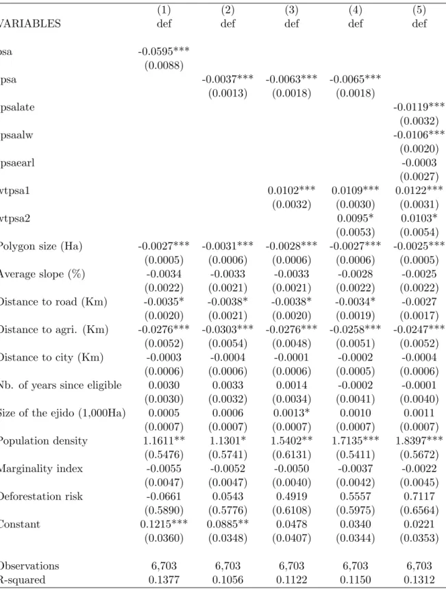
Estimation (2) in Table1allows us to compute propensity scores. We restrict our sample to the common support and to the first nearest neighbors with a tolerance limit of 0.1% of difference in propensity scores between treated and the match. We drop 3,021 observations. Our final sample is composed of 7,331 observations. The distribution of propensity scores for PSA-H beneficiaries and non-beneficiaries once restricted to this subsample is presented in Figure 6. We note that both distributions are highly skewed and that overlapping areas are reasonably large.
Table 1: Propensity score estimation: Probit
(1) (2)
VARIABLES psa psa
Polygon size (Ha) 0.0122***
(0.0017) Average slope (%) 0.0038 (0.0111) Distance to road (Km) 0.0013 (0.0053) Distance to agri. (Km) 0.2592*** (0.0210) Distance to city (Km) -0.0069*** (0.0019)
Nb. of years since eligible 0.1364***
(0.0091) Size of the ejido (1,000Ha) -0.0370*** -0.0424***
(0.0014) (0.0016) Population density -24.1682*** -14.9914*** (1.0856) (1.3838) Marginality index -0.1023*** -0.1273*** (0.0196) (0.0206) Deforestation risk -11.4220*** -12.9759*** (2.2838) (2.3987) Constant 1.1304*** -0.1701 (0.0867) (0.1260) Pseudo R-squared 0.0851 0.1198 Observations 10,352 10,352
Standard errors in parentheses adjusted for 62 clusters at the ejido-level. *** p<0.01, ** p<0.05, * p<0.1
Figure 6: Common support
0 .2 .4 .6 .8 1
Propensity Score
Untreated Treated
5.2. Additionality
Table2presents the results regarding additionality estimated using OLS. Column (1) presents the results using a dummy variable (Equation2). Column (2) introduces the time spent in the program (Equation4). Both variables display a negative and significant effect on deforestation. A five year contract generates an average additionality of 1.7%, which, for a polygon of 25 ha corresponds, to 0.425 ha. Note that higher propensity scores are also associated with lower de-forestation risk which confirms mistargeting and the necessity to account for the selection bias in our results. Regarding control variables, one should be careful in interpreting the estimates. For many of them including Distance to agri or Deforestation risk, their impact is captured by the propensity scores. Introducing them allows us only to correct for remaining imbalances between the control and the treated group after controlling for P score.
Column (3) and (4) introduce the two variables that capture leakages. The variable wtpsa1, that captures leakages within the ejidos, has a significant effect and in the expected direction. These results tend to show that if the program effectively decreases pressure in enrolled parcels, this pressure is displaced to other areas of the ejido. However, the coefficient associated with variable wtpsa2, that captures leakages in surrounding ejidos, is not significant. Nevertheless, it is not possible to directly interpret the difference of magnitude between the two coefficients. The variable wtpsa1 is the average protection of one hectare in the ejido and does not only
depend on the number of hectares protected but also on the total stock of forest. Moreover, looking at the issue of heterogeneity allows us to better explain the results presented in Table
2.
Table 2: Impact of the PSA-H and leakages
(1) (2) (3) (4)
VARIABLES def def def def
psa -0.0477*** (0.0078) tpsa -0.0034*** -0.0049*** -0.0051*** (0.0012) (0.0017) (0.0016) wtpsa1 0.0052** 0.0055** (0.0025) (0.0025) wtpsa2 0.0038 (0.0046) Pscore -2.1233*** -2.1946*** -2.1521*** -2.1393*** (0.4131) (0.4087) (0.4045) (0.4074) Polygon size (Ha) 0.0069*** 0.0072*** 0.0071*** 0.0071***
(0.0017) (0.0017) (0.0017) (0.0017) Average slope (%) -0.0017 -0.0018 -0.0017 -0.0015 (0.0021) (0.0019) (0.0019) (0.0019) Distance to road (Km) -0.0017 -0.0015 -0.0015 -0.0015 (0.0012) (0.0012) (0.0012) (0.0012) Distance to agri. (Km) -0.0061*** -0.0063*** -0.0061*** -0.0061*** (0.0012) (0.0012) (0.0012) (0.0012) Distance to city (Km) -0.0061*** -0.0063*** -0.0061*** -0.0061*** (0.0012) (0.0012) (0.0012) (0.0012) Nb. of years since eligible 0.1074*** 0.1110*** 0.1082*** 0.1069***
(0.0210) (0.0208) (0.0208) (0.0212) Size of the ejido (1,000 Ha) -0.0322*** -0.0332*** -0.0322*** -0.0321***
(0.0062) (0.0062) (0.0062) (0.0062) Population density -10.8352*** -11.2822*** -10.8166*** -10.6626*** (2.3299) (2.3214) (2.3622) (2.3677) Marginality index -0.1068*** -0.1100*** -0.1078*** -0.1066*** (0.0195) (0.0190) (0.0187) (0.0191) Deforestation risk -9.5186*** -9.8493*** -9.5025*** -9.4022*** (2.1379) (2.0475) (2.0380) (2.0318) Constant 1.0563*** 1.0663*** 1.0286*** 1.0167*** (0.1937) (0.1891) (0.1909) (0.1914) Observations 7,331 7,331 7,331 7,331 R-squared 0.1497 0.1243 0.1261 0.1266
Standard errors in parentheses adjusted for 62 clusters at the ejido-level. *** p<0.01, ** p<0.05, * p<0.1
A last concern with the interpretation of our results is related with the argument made by Angelsen (1995). He wonders if the clearing of secondary vegetation should be considered deforestation. He argues that if some area is managed under a shifting cultivation agricultural system, clearing of secondary vegetation should not be considered as deforestation. Only when
the system penetrates in untouched forest we could regard that advance as deforestation. This might especially be a concern in our case since the milpa system is used in the region (it designs a cycle where areas are cultivated for a few years, then the area is left fallow for some years, before being cultivated again after slashing and burning the area). However, slash-and burn tends to be abandoned in the area. Moreover, according to our remote sensing analysis, less than 15% of the forest that has been cleared between 2005 and 2012 has been transformed into small fields of slash-and-burn agriculture. On the contrary, around 85% has been cleared to establish mechanized sedentary agricultural fields or pasture. Therefore, we are confident that our results capture mainly permanent forest-clearing.
5.3. Heterogeneity over time
Table3 presents the results of the estimation of Equation5. In this model, we differentiate between polygons that were only in the program in the early years and did not renew their contracts (tpsaearl), those that only entered at the end of the period (tpsalate), and those that always were in the program (tpsaalw) between 2005 and 2012. After the pre-matching, our sample included 15,305 hectares that have not been renewed, 21,314 ha that have been renewed and 30,057 ha that have only been enrolled after 2008. Section4.4.2provides more details about how the different variables are computed.
Looking at Table3, we note that the coefficient associated with the tpsaearl variable is not significant. Two hypotheses can be advanced to explain this result. One explanation would be that these forests were not threatened. Sims et al.(2014) show that over the years, the PSA-H has improved its focus on threatened forest. This could explain why these areas have not been renewed. However, this does not fit with the results fromAlix-Garcia et al.(2012). The authors studied the impact on the first cohort of PSA-H beneficiaries (2004) in Mexico. They estimated avoided deforestation over the 2004-2006 period and found a net additionality of the program before leakages (deforestation was reduced by 50% in enrolled parcels). Even if, contrary to
Alix-Garcia et al.(2012), our study only focuses on a selected part of Mexico, we think this first explanation is not sufficient to explain our results. Another plausible explanation would be that the ejidatarios decided to withdraw those lands from the program in order to clear them. Hence, if the PSA-H protected the forest during five years, the ejidatarios caught up on their original deforestation rate in the subsequent years. A simple t-test of deforestation rate between the
Table 3: Impact heterogeneity (1) VARIABLES def tpsalate -0.0110*** (0.0027) tpsaalw -0.0090*** (0.0018) tpsaearl 0.0014 (0.0026) wtpsa1 0.0067** (0.0026) wtpsa2 0.0045 (0.0047) Pscore -2.1525*** (0.4118)
Polygon size (Ha) -2.1525***
(0.4118) Average slope (%) -0.0014 (0.0020) Distance to road (Km) -0.0010 (0.0011) Distance to agri. (Km) 0.1686*** (0.0353) Distance to city (Km) -0.0064*** (0.0013) Nb. of years since eligible -0.0064***
(0.0013) Size of the ejido (1,000Ha) -0.0322***
(0.0063) Population density -10.6372*** (2.3993) Marginality index -0.1055*** (0.0196) Deforestation risk -9.3340*** (2.0564) Constant 1.0132*** (0.1930) Observations 7,331 R-squared 0.1434
Standard errors in parentheses adjusted for 62 clusters at the ejido-level. *** p<0.01, ** p<0.05, * p<0.1
early beneficiary polygons and the other treated comforts us in this interpretation. Deforestation rates between 2005 and 2012 are on average five times higher for the early beneficiary and this difference is statistically significant.
Moreover, we note that once this heterogeneity is taken into account, the magnitude of the impact for the variables tpsalate and tpsaalw is very similar and the coefficients are larger than the figures shown in Table 2. Remark that these results provide empirical backing for an acknowledged fear about PES program’s impact: the potential lack of permanence of the impact.
Furthermore, based on Table 3’s coefficients, we calculate a back-to-the-envelope estimation . With a 95% confidence interval, the avoided deforestation between 2005 and 2012 in protected parcels is between 1,023 and 2,751 ha. Proportionally to the numbers of hectares enrolled, this corresponds to an additionality between 1.3 and 3.5% (recall that in the regression sample 77,390 hectares have been enrolled in the program at least one year between 2005 and 2012). However, we estimate that leakage effects within the ejidos would vary between 218 ha and 2,912 ha. This estimation tends to show that most of the avoided deforestation in the ejido has been displaced in other areas of the ejido. In the more optimistic scenario involving the maximum of avoided deforestation and the minimum leakages, the additionality of the PSA-H corresponds to approximately 3% of the areas enrolled. In the worst case scenario, deforestation is increased by the program, suggesting not only displacements of deforestation but potentially a relaxation of the credit constraint.
6. Robustness tests
We run several robustness tests using alternative estimators, sample selection, and model specification. Regression tables are displayed in the Appendix.
6.1. Propensity Score Weighting
Robins et al. (1995) propose to use Propensity Score Weighting (PSW) in order to esti-mate programs impact. PSW allows to balance covariates between treated and non-treated observations, which might be important if treated and untreated have very different covariates distributions. It is implemented as follows (Hirano and Imbens,2001;Lunceford and Davidian,
1. Estimating propensity scores using a probit or a logit model 2. Generating sample weights using predicted propensity scores 3. Estimating the model using Weighted Least Squares (WLS)
Based on the estimation of the propensity score presented in Table 1, additionality of the program is estimated using WLS. Thus we reproduce the results presented in Table 2 and 3
with sample weights equals to:
wij =
P scoreij/(1 − P scoreij) if psaij = 0
1 if psaij = 1
(6)
Results, presented in the Appendix, Table 4, are almost identical to the ones presented in Section Main results.
6.2. Pre-matching using Covariate matching
We used PSM in our analysis in order to select a control group and account for the selec-tion bias. An alternative to this approach is to use Covariate matching which is based, not on propensity scores, but on Mahalanobis vectorial distance. It is crucial to control for the propensity scores in the estimations so, for the purpose of consistency, we have chosen PSM to select our sample. However, propensity score methods might reveal biased, if treated and un-treated have very different covariate distributions. Thus, we provide the results using Covariate matching as a robustness test.
Results are presented in Table 5 in the Appendix. The estimates are not significantly different from those obtained with PSM.
6.3. Withdrawal of the largest ejido
As it can be seen Figure2, there is one ejido located in the North-West of Cono Sur that is much larger than the others. This ejido represents approximately 10% of our area of study. In order to ensure that this ejido alone is not driving our results, we run a robustness test without this ejido. The results of this estimation are presented in Table 6in the Appendix and confirm our results.
6.4. Introduction of ejido individual dummies
While we introduced several control variables at the ejido-level, there might remain ejido’s characteristics that affect the entry into the program and deforestation. A solution to that is to introduce individual dummies at the ejido-level. With ejido dummies, we cannot estimate the magnitude of leakages. Nevertheless, we can check for the robustness of our results on additionality and heterogeneity of the program over time.
Results, presented in Table 7, are once again really close to the ones presented in Section5.
6.5. Selection and leakages estimation
The pre-matching allows us to take into account the selection process in the estimation. Section 5.1 showed that the polygons under protection were less threatened. Therefore, the pre-matching conducted us to keep less threatened forest in our sample, which could bias our estimations of leakages. As a matter of fact, leakages may be lower in the regression sample than the entire sample.
To check for the existence of such bias, we run our main models without sample selection and propensity scores. The result of this naive estimation are presented in column (1) to (4) in Table8in the Appendix. The coefficients associated to the wtpsa1 variable are still significantly different from zero, but larger than the ones displayed in Table 2, as suspected.
Note that the coefficients associated to the treatment variables are also slightly higher to the ones found in Table 2. This modest discrepancy with the main results is not really surprising considering the fact that about a third of the polygons received the PSA-H. Note that the pre-matching would have had a more substantial impact if the proportion of treated polygons had been lower.
Column (5) and (6) propose an estimation without any control variables. The result of this estimation clearly shows that, without any control on observable covariates, the impact of the program would have been highly overestimated.
7. Conclusion
We proposed to assess the impact of a PES program over several cohorts. We estimated additionality, leakages and permanence of the program. Our approach explicitly considers land
tenure in the unit of observation, but also allows us to take into account heterogeneity of pro-tection status within forest parcels owned by the same landowner. Moreover, we simultaneously estimate direct impact and leakages using tools provided by spatial econometrics. We also intro-duce heterogeneity of exposure to the treatment as we consider the time spent in the program and contract renewal. Our econometric model is estimated on a sample of beneficiaries and applicants, and we use matching to pre-process the data.
We applied this methodology in the context of the Mexican PSA-H in the Cono Sur of Yucatan State. Our results suggest a strong mistargeting issue of PSA-H allocation within the ejidos. Indeed, everything else equal, and after controlling for PSA-H reception, the probability to receive the program is inversely correlated with actual deforestation. Overall, we find that deforestation is reduced by 2.45% on enrolled parcels. We also find evidence of leakage effects. In our study area, most of the deforestation has been displaced to other areas within the ejidos. We do not find evidence of leakage effects in the neighbouring ejidos. However, considering that most of the deforestation has been displaced within the ejidos, there are no reasons to think the supply of agricultural products decreased. Therefore, leakages in neighbouring ejidos were very unlikely to occur. Part of our results might be attributed to shifting-cultivation under the milpa system (about 15% of total deforestation), but most deforestation is linked to clearing of old-growth forests (about 85% of total deforestation).
Moreover, looking at impact heterogeneity, we note that no additionality has been found in the areas where the ejidatarios decided not to renew the contracts after five years. One possible explanation is that the ejidatarios withdraw lands from the program in order to clear it. These results provide empirical backing for two acknowledged fears about PES program’s impact: existence of deforestation leakages, and the potential lack of permanence of the impact. We are confident in our results that passed all the robustness checks inflicted.
The implications of our study are twofold. First, for future IE, we provide empirical backing for the claim that care should be taken in monitoring the indirect effects of the program over space and time. Leakage effects may undermine or even offset the additionality of the program. Moreover, one may fear a clearing of protected lands after the end of the program. Therefore, evaluating the impact of a program on protected land and only during the time the area is under conservation may lead to strongly overestimate the program’s impact. Most IEs have focused
on additionality while the real challenge for PES schemes may be permanence.
Second, from a policy perspective, monitoring leakages and post-program clearing will not prevent these effects. PES schemes are based on voluntary enrollment and conservation cannot be enforced on all forest parcels over time without the beneficiary’s agreement. Nevertheless, although the existence of leakages is not questionable, at least two policy options remain for policy makers. First, the evidence of leakages does not imply an absence of impact of the program on treated parcels. Even if the overall level of deforestation is not affected by the program implementation, parcels covered by the program suffer from less deforestation than those not covered by the scheme (additionality). Thus, targeting parcels with high ecological value might help to achieve conservation goals. Second, providing alternative livelihood options and sustainable use of the forest cover through agroforestry or sustainable forestry might be a relevant alternative to ensure both permanence and minimum leakages (Aukland et al.,2003). However, as highlighted by Karsenty (2011), it would require combining the incentives of PES with investment in order to relax dependance on forest clearing.
References
Alix-Garcia, J., Sims, K. R., Yanez-Pagans, P., Radeloff, V. C., and Shapiro, E. (2015). Only one tree from each seed? Environmental effectiveness and poverty alleviation in programs of payments for ecosystem services. American Economic Journal - Economic Policy, Forthcom-ing.
Alix-Garcia, J. M., Shapiro, E. N., and Sims, K. R. (2012). Forest conservation and slippage: Evidence from Mexico’s national payments for ecosystem services program. Land Economics, 88(4):613–638.
Amin, A., Choumert, J., Motel, P. C., Combes, J.-L., Kere, E. N., Ongono-Olinga, J. G., and Schwartz, S. (2014). A spatial econometric approach to spillover effects between protected areas and deforestation in the Brazilian Amazon. S´erie Etudes et Documents du CERDI, Num. 06.
Andam, K. S., Ferraro, P. J., Sims, K. R., Healy, A., and Holland, M. B. (2010). Protected areas reduced poverty in Costa Rica and Thailand. Proceedings of the National Academy of Sciences, 107(22):9996–10001.
Angelsen, A. (1995). Shifting cultivation and “deforestation”: a study from indonesia. World Development, 23(10):1713–1729.
Angelsen, A. and Kaimowitz, D. (1999). Rethinking the causes of deforestation: Lessons from economic models. The World Bank Research Observer, 14(1):73–98.
Angelsen, A. and Kaimowitz, D. (2001). Agricultural technologies and tropical deforestation. CABi.
Arriagada, R. A., Ferraro, P., Sills, E., Pattanayak, S., and S.Cordero-Sancho (2012). Do payments for environmental services affect forest cover? A farm-level evaluation from Costa Rica. Land Economics, 88(2):382–399.
Aukland, L., Costa, P. M., and Brown, S. (2003). A conceptual framework and its application for addressing leakage: the case of avoided deforestation. Climate Policy, 3(2):123–136. Austin, P. C. (2011). An introduction to propensity score methods for reducing the effects of
confounding in observational studies. Multivariate Behavioral Research, 46(3):399–424. Baylis, K., Honey-Ros´es, J., B¨orner, J., Corbera, E., Ezzine-de Blas, D., Ferraro, P. J., Lapeyre,
R., Persson, U. M., Pfaff, A., and Wunder, S. (2015). Mainstreaming impact evaluation in nature conservation. Conservation Letters, Forthcoming.
Bray, D. B., Merino-P´erez, L., Negreros-Castillo, P., Segura-Warnholtz, G., Torres-Rojo, J. M., and Vester, H. F. M. (2003). Mexico’s community-managed forests as a global model for sustainable landscapes. Conservation Biology, 17(3):672–677.
Canavire-Bacarreza, G. and Hanauer, M. M. (2013). Estimating the impacts of Bolivia’s pro-tected areas on poverty. World Development, 41:265–285.
Chomitz, K. M. (2002). Baseline, leakage and measurement issues: how do forestry and energy projects compare? Climate Policy, 2(1):35–49.
Corbera, E., Gonz´alez Soberanis, C., and Brown, K. (2009). Institutional dimensions of pay-ments for ecosystem services: An analysis of Mexico’s carbon forestry programme. Ecological Economics, 68(3):743 – 761.
Costedoat, S., Corbera, E., Ezzine-de Blas, D., Honey-Ros´es, J., Baylis, K., and Castillo-Santiago, M. (2015). How effective are biodiversity conservation payments in Mexico? PloS one, 10(3):e0119881.
Delacote, P., Robinson, E. J., Roussel, S., et al. (2015). Deforestation, leakage and avoided deforestation policies: A spatial analysis. Document de recherche du LAMETA, No. 2015-06. Ferraro, P. J. (2009). Counterfactual thinking and impact evaluation in environmental policy.
New Directions for Evaluation, 2009(122):75–84.
Ferraro, P. J. and Hanauer, M. M. (2014). Advances in measuring the environmental and social impacts of environmental programs. Annual Review of Environment and Resources, 39:495–517.
Ferraro, P. J. and Kiss, A. (2002). Direct payments to conserve biodiversity. Science, 298(5599):1718–1719.
Ferraro, P. J. and Pattanayak, S. K. (2006). Money for nothing? A call for empirical evaluation of biodiversity conservation investments. PLoS biology, 4(4).
Garc´ıa-Amado, L. R., Ruiz P´erez, M., Reyes Escutia, F., Barrasa Garc´ıa, S., and Contr-eras Mej´ıa, E. (2011). Efficiency of payments for environmental services: Equity and addi-tionality in a case study from a biosphere reserve in Chiapas, Mexico. Ecological Economics, 70(12):2361 – 2368.
Geres, R. and Michaelowa, A. (2002). A qualitative method to consider leakage effects from CDM and JI projects. Energy Policy, 30(6):461–463.
Hirano, K. and Imbens, G. W. (2001). Estimation of causal effects using propensity score weighting: An application to data on right heart catheterization. Health Services and Out-comes research methodology, 2(3-4):259–278.
Honey-roses, J., Baylis, K., and Ramirez, M. I. (2011). A spatially explicit estimate of avoided forest loss. Conservation Biology, 25(5):1032–1043.
Jayachandran, S. (2013). Liquidity constraints and deforestation: The limitations of payments for ecosystem services. American Economic Review, 103(3):309–13.
Joppa, L. and Pfaff, A. (2010). Reassessing the forest impacts of protection. Annals of the New York Academy of Sciences, 1185(1):135–149.
Joppa, L. N. and Pfaff, A. (2009). High and far: Biases in the location of protected areas. PLoS One, 4(12):e8273.
Karsenty, A. (2011). Combining conservation incentives with investment. Perspective, Environ-mental Policies, 7.
Karsenty, A. and Ezzine de Blas, D. (2014). Du m´esusage des m´etaphores - les paiements pour services environnementaux sont-ils des instruments de marchandisation de la nature ? In Halpern P. Lascoumes, P. L. G., editor, L’instrumentation de l’action publique - Controverses, r´esistances, effets, pages 161–189. Presses de Sciences Po.
Lunceford, J. K. and Davidian, M. (2004). Stratification and weighting via the propensity score in estimation of causal treatment effects: A comparative study. Statistics in medicine, 23(19):2937–2960.
Martin Persson, U. and Alp´ızar, F. (2013). Conditional cash transfers and payments for environ-mental services - a conceptual framework for explaining and judging differences in outcomes. World Development, 43:124–137.
Miteva, D. A., Pattanayak, S. K., and Ferraro, P. J. (2012). Evaluation of biodiversity policy instruments: what works and what doesn’t? Oxford Review of Economic Policy, 28(1):69–92. Mu˜noz-Pi˜na, C., Guevara, A., Torres, J. M., and Bra˜na, J. (2008). Paying for the hydrolog-ical services of mexico’s forests: Analysis, negotiations and results. Ecologhydrolog-ical Economics, 65(4):725 – 736.
Ezzine de Blas, D., Farley, J., Froger, G., et al. (2013). Payments for ecosystem services and the fatal attraction of win-win solutions. Conservation Letters, 6(4):274–279.
Murray, B. C., McCarl, B. A., and Lee, H.-C. (2004). Estimating leakage from forest carbon sequestration programs. Land Economics, 80(1):109–124.
Pattanayak, S. K., Wunder, S., and Ferraro, P. J. (2010). Show me the money: Do payments supply environmental services in developing countries? Review of Environmental Economics and Policy, 4(2):254–274.
Pfaff, A., Robalino, J., Sanchez-Azofeifa, G., Andam, K., and Ferraro, P. (2009). Park location affects forest protection: Land characteristics cause differences in park impacts across Costa Rica. The BE Journal of Economic Analysis and Policy, 9(2):1–24.
Pirard, R., Bill´e, R., and Sembr´es, T. (2010). Questioning the theory of payments for ecosystem services in light of emerging experience and plausible developments. Technical report, IDDRI Analyses 4/10.
Ravallion, M. (2007). Evaluating anti-poverty programs. Handbook of development economics, 4:3787–3846.
Robalino, J. and Pfaff, A. (2013). Ecopayments and deforestation in Costa Rica: A nationwide analysis of psa’s initial years. Land Economics, 89(3):432–448.
Robins, J. M., Rotnitzky, A., and Zhao, L. P. (1995). Analysis of semiparametric regression models for repeated outcomes in the presence of missing data. Journal of the American Statistical Association, 90(429):106–121.
Schwarze, R., Niles, J. O., and Olander, J. (2002). Understanding and managing leakage in forest–based greenhouse–gas–mitigation projects. Philosophical Transactions of the Royal So-ciety of London. Series A: Mathematical, Physical and Engineering Sciences, 360(1797):1685– 1703.
Sims, K. R. (2010). Conservation and development: Evidence from thai protected areas. Journal of Environmental Economics and Management, 60(2):94–114.
Sims, K. R., Alix-Garcia, J. M., Shapiro-Garza, E., Fine, L., Radeloff, V. C., Aronson, G., Castillo, S., Ramirez-Reyes, C., and Yanez-Pagans, P. (2014). Improving environmental and social targeting through adaptive management in Mexico’s payments for hydrological services program. Conservation Biology, 28(5):1151–1159.
Sohngen, B. and Brown, S. (2004). Measuring leakage from carbon projects in open economies: a stop timber harvesting project in Bolivia as a case study. Canadian Journal of Forest Research, 34(4):829–839.
UNEP, Trends, F., and The Katoomba Group (2008). Payments for ecosystem services: Getting started. UNON Publishing Services, Nairobi.
Vansteelandt, S. and Daniel, R. (2014). On regression adjustment for the propensity score. Statistics in Medicine, 33(23):4053–4072.
Watson, R. T., Noble, I. R., Bolin, B., Ravindranath, N., Verardo, D. J., Dokken, D. J., et al. (2000). Land use, land-use change and forestry: a special report of the Intergovernmental Panel on Climate Change. Cambridge University Press.
Wu, J. (2000). Slippage effects of the conservation reserve program. American Journal of Agricultural Economics, 82(4):979–992.
Wu, J., Zilberman, D., and Babcock, B. A. (2001). Environmental and distributional impacts of conservation targeting strategies. Journal of Environmental Economics and Management, 41(3):333–350.
Wunder, S. (2008). How should we deal with leakage? In Moving ahead with REDD: is-sues, options and implications. Center for International Forestry Research (CIFOR), Bogor, Indonesia.
Wunder, S. (2015). Revisiting the concept of payments for environmental services. Ecological Economics, 117:234 ˝U243.
Appendix
Table 4: Robustness tests: Estimation using PSW
(1) (2) (3) (4) (5)
VARIABLES def def def def def
psa -0.0453*** (0.0026) tpsa -0.0050*** -0.0076*** -0.0077*** (0.0006) (0.0008) (0.0008) tpsalate -0.0142*** (0.0010) tpsaalw -0.0111*** (0.0007) tpsaearl -0.0010 (0.0011) wtpsa1 0.0087*** 0.0092*** 0.0099*** (0.0013) (0.0013) (0.0014) wtpsa2 0.0035 0.0038* (0.0021) (0.0021) Polygon size (Ha) -0.0029*** -0.0029*** -0.0026*** -0.0026*** -0.0024***
(0.0002) (0.0002) (0.0002) (0.0002) (0.0002) Average slope (%) -0.0043*** -0.0040*** -0.0036*** -0.0034*** -0.0034*** (0.0011) (0.0011) (0.0011) (0.0011) (0.0011) Distance to road (Km) -0.0030*** -0.0028*** -0.0028*** -0.0028*** -0.0025*** (0.0004) (0.0005) (0.0004) (0.0004) (0.0004) Distance to agri. (Km) -0.0305*** -0.0303*** -0.0282*** -0.0277*** -0.0271*** (0.0015) (0.0016) (0.0015) (0.0015) (0.0015) Distance to city (Km) -0.0005*** -0.0006*** -0.0004** -0.0004** -0.0006*** (0.0002) (0.0002) (0.0002) (0.0002) (0.0002)
Nb. of years since eligible 0.0014 0.0023* 0.0016 0.0009 0.0011
(0.0012) (0.0012) (0.0012) (0.0014) (0.0014)
Size of the ejido (1,000Ha) 0.0009*** 0.0008*** 0.0012*** 0.0011*** 0.0013***
(0.0001) (0.0001) (0.0001) (0.0001) (0.0001) Population density 1.5335*** 1.4068*** 1.8263*** 1.9102*** 1.9815*** (0.1498) (0.1573) (0.1677) (0.1727) (0.1726) Marginality index -0.0059*** -0.0066*** -0.0063*** -0.0056*** -0.0041** (0.0018) (0.0018) (0.0018) (0.0018) (0.0018) Deforestation risk 0.9246*** 0.8052*** 0.9050*** 0.9720*** 1.0768*** (0.2343) (0.2356) (0.2353) (0.2374) (0.2384) Constant 0.0884*** 0.0754*** 0.0438*** 0.0367*** 0.0293** (0.0127) (0.0130) (0.0133) (0.0133) (0.0133) Observations 10,352 10,352 10,352 10,352 10,352 R-squared 0.1399 0.1190 0.1239 0.1243 0.1359
Standard errors in parentheses. *** p<0.01, ** p<0.05, * p<0.1
Table 5: Robustness tests: Selection using covariate matching
(1) (2) (3) (4) (5)
VARIABLES def def def def def
psa -0.0595*** (0.0088) tpsa -0.0037*** -0.0063*** -0.0065*** (0.0013) (0.0018) (0.0018) tpsalate -0.0119*** (0.0032) tpsaalw -0.0106*** (0.0020) tpsaearl -0.0003 (0.0027) wtpsa1 0.0102*** 0.0109*** 0.0122*** (0.0032) (0.0030) (0.0031) wtpsa2 0.0095* 0.0103* (0.0053) (0.0054) Polygon size (Ha) -0.0027*** -0.0031*** -0.0028*** -0.0027*** -0.0025***
(0.0005) (0.0006) (0.0006) (0.0006) (0.0005) Average slope (%) -0.0034 -0.0033 -0.0033 -0.0028 -0.0025 (0.0022) (0.0021) (0.0021) (0.0022) (0.0022) Distance to road (Km) -0.0035* -0.0038* -0.0038* -0.0034* -0.0027 (0.0020) (0.0021) (0.0020) (0.0019) (0.0017) Distance to agri. (Km) -0.0276*** -0.0303*** -0.0276*** -0.0258*** -0.0247*** (0.0052) (0.0054) (0.0048) (0.0051) (0.0052) Distance to city (Km) -0.0003 -0.0004 -0.0001 -0.0002 -0.0004 (0.0006) (0.0006) (0.0006) (0.0005) (0.0006)
Nb. of years since eligible 0.0030 0.0033 0.0014 -0.0002 -0.0001
(0.0030) (0.0032) (0.0034) (0.0041) (0.0040)
Size of the ejido (1,000Ha) 0.0005 0.0006 0.0013* 0.0010 0.0011
(0.0007) (0.0007) (0.0007) (0.0007) (0.0007) Population density 1.1611** 1.1301* 1.5402** 1.7135*** 1.8397*** (0.5476) (0.5741) (0.6131) (0.5411) (0.5672) Marginality index -0.0055 -0.0052 -0.0050 -0.0037 -0.0022 (0.0047) (0.0047) (0.0040) (0.0042) (0.0045) Deforestation risk -0.0661 0.0543 0.4919 0.5557 0.7117 (0.5890) (0.5776) (0.6108) (0.5975) (0.6564) Constant 0.1215*** 0.0885** 0.0478 0.0340 0.0221 (0.0360) (0.0348) (0.0407) (0.0344) (0.0353) Observations 6,703 6,703 6,703 6,703 6,703 R-squared 0.1377 0.1056 0.1122 0.1150 0.1312
Standard errors in parentheses adjusted for 62 clusters at the ejido-level. *** p<0.01, ** p<0.05, * p<0.1
Table 6: Robustness tests: Estimation without the largest ejido
(1) (2) (3) (4) (5)
VARIABLES def def def def def
psa -0.0513*** (0.0086) tpsa -0.0034*** -0.0048*** -0.0050*** (0.0012) (0.0017) (0.0017) tpsalate -0.0112*** (0.0034) tpsaalw -0.0093*** (0.0019) tpsaearl 0.0013 (0.0027) wtpsa1 0.0046* 0.0050* 0.0066** (0.0027) (0.0026) (0.0027) wtpsa2 0.0041 0.0049 (0.0046) (0.0046) Pscore -1.9744*** -2.0982*** -2.0807*** -2.0612*** -2.1150*** (0.4679) (0.4788) (0.4796) (0.4860) (0.4916)
Polygon size (Ha) 0.0063*** 0.0067*** 0.0068*** 0.0067*** 0.0072***
(0.0020) (0.0021) (0.0021) (0.0021) (0.0021) Average slope (%) -0.0025 -0.0025 -0.0024 -0.0022 -0.0018 (0.0022) (0.0020) (0.0020) (0.0020) (0.0021) Distance to road (Km) -0.0014 -0.0014 -0.0015 -0.0014 -0.0008 (0.0016) (0.0016) (0.0017) (0.0017) (0.0015) Distance to agri. (Km) 0.1532*** 0.1617*** 0.1612*** 0.1601*** 0.1662*** (0.0412) (0.0417) (0.0417) (0.0421) (0.0429) Distance to city (Km) -0.0062*** -0.0065*** -0.0063*** -0.0063*** -0.0066*** (0.0012) (0.0013) (0.0013) (0.0013) (0.0014)
Nb. of years since eligible 0.1003*** 0.1066*** 0.1051*** 0.1034*** 0.1061***
(0.0239) (0.0243) (0.0245) (0.0251) (0.0252)
Size of the ejido (1,000Ha) -0.0273*** -0.0297*** -0.0293*** -0.0290*** -0.0299***
(0.0076) (0.0078) (0.0078) (0.0079) (0.0080) Population density -10.1203*** -10.8462*** -10.5384*** -10.3469*** -10.5208*** (2.6093) (2.6789) (2.7255) (2.7544) (2.7971) Marginality index -0.0993*** -0.1048*** -0.1039*** -0.1023*** -0.1033*** (0.0217) (0.0224) (0.0224) (0.0229) (0.0234) Deforestation risk -8.6654*** -9.3078*** -9.1070*** -8.9592*** -9.0658*** (2.3660) (2.3577) (2.3733) (2.3922) (2.4285) Constant 0.9898*** 1.0245*** 0.9999*** 0.9843*** 0.9960*** (0.2120) (0.2158) (0.2188) (0.2216) (0.2243) Observations 6,801 6,801 6,801 6,801 6,801 R-squared 0.1480 0.1210 0.1223 0.1229 0.1398
Standard errors in parentheses adjusted for 61 clusters at the ejido-level. *** p<0.01, ** p<0.05, * p<0.1