Publisher’s version / Version de l'éditeur:
Canadian Geotechnical Journal, 14, 4, pp. 620-627, 1977-11
READ THESE TERMS AND CONDITIONS CAREFULLY BEFORE USING THIS WEBSITE. https://nrc-publications.canada.ca/eng/copyright
Vous avez des questions? Nous pouvons vous aider. Pour communiquer directement avec un auteur, consultez la première page de la revue dans laquelle son article a été publié afin de trouver ses coordonnées. Si vous n’arrivez pas à les repérer, communiquez avec nous à PublicationsArchive-ArchivesPublications@nrc-cnrc.gc.ca.
Questions? Contact the NRC Publications Archive team at
PublicationsArchive-ArchivesPublications@nrc-cnrc.gc.ca. If you wish to email the authors directly, please see the first page of the publication for their contact information.
NRC Publications Archive
Archives des publications du CNRC
This publication could be one of several versions: author’s original, accepted manuscript or the publisher’s version. / La version de cette publication peut être l’une des suivantes : la version prépublication de l’auteur, la version acceptée du manuscrit ou la version de l’éditeur.
Access and use of this website and the material on it are subject to the Terms and Conditions set forth at
Evidence of creep in steep natural slopes of champlain sea clay
Eden, W. J.
https://publications-cnrc.canada.ca/fra/droits
L’accès à ce site Web et l’utilisation de son contenu sont assujettis aux conditions présentées dans le site LISEZ CES CONDITIONS ATTENTIVEMENT AVANT D’UTILISER CE SITE WEB.
NRC Publications Record / Notice d'Archives des publications de CNRC:
https://nrc-publications.canada.ca/eng/view/object/?id=ad166adf-e8a3-4fa1-93f0-0009dec6da94 https://publications-cnrc.canada.ca/fra/voir/objet/?id=ad166adf-e8a3-4fa1-93f0-0009dec6da94
BLDG
- - - -- - --
-----
-
SerTH1
d / " z ; '
34
National Research Conseil national
b
Council Canada de recherches Canada-
A N A L Y Z E D
EVIDENCE OF CREEP IN STEEP NATURAL SLOPES OF
CHAMPLAIN SEA CLAY
by W . J . Eden
,*/
- - H - - - f j : r
Reprinted from
7
L. v t:LF, :!r, p.vcT-b.-.d
Canadian Geotechnical Journal,
- ~ \ ~ z k . w
-
Vol. 14, No. 4, November 1977
1
!?
8
P.
1
9
1918
- .
DBR Paper No. 734
65368
Division of Building Researchmice 25 cents OTTAWA NRCC 16246
AN
A ~ ~ Z E p
NOTE
Evidence of creep in steep natural slopes of Champlain Sea clay1
W. J. EDEN
Geotechnical Section, Division of Building Research, NationalResearch Council of Canada, Ottawa, Canada KIA OR6
Received October 12, 1976 Accepted June 14, 1977
Three types of evidence of deep seated creep of steep natural slopes are considered: surface manifestations such as fissures and depressions; inclinometer measurements-on three slopes in the Ottawa area; and movements of a bridge superstructure spanning a steep sided ravine.
Results of measurements show that the movements are not continuous but occur in response to seasonal high levels of the groundwater table. The implications of the movements are discussed in relation to the stability of clay slopes.
On considere trois types de symptbmes de fluage profond dans des pentes naturelles escarpees: des phenomenes de surface tels que des fissures ou des depressions; des mesures in- clinometriques dans trois pentes de la region d'ottawa; les mouvernents d'un pont traversant un ravin a parois escarpees.
Les resultats des mesures montrent que les mouvements ne sont pas continus mais font suite a I'occurrence saisoniere de hauts niveaux de nappe phreatique. Les consequences de ces mouve- ments sont discutees en relation avec la stabilite des pentes argileuses.
[Traduit par la revue]
Can. Geotech. J., 14,620 (1977)
The phenomenon of creep is discussed in is discussed in the context of past studies on this paper in a broad sense; i.e. as movements slope stability, in which the stability of slopes that occur in steep clay slopes that do not in- in the fissured weathered crust of the Cham- volve the generation of a well-defined surface plain Sea clays has been examined. These of rupture, and which may or may not be a studies have been previously described by Eden continuing nature. Creep should be distin- and Mitchell (1970, 1973) and Eden (1975
1.
guished from shallow seated downhill move-ments, such as solifluction, which occur in the Surface Evidence of Creep layer of soil affected by seasonal frost action.
The first case illustrates the type of move- The most obvious evidence of such move-
ment that occurs adjacent to an active land- ments are found adjacent to slope failures.
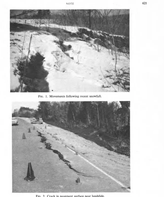
slide. In April 1973, a small slope failure Behind the back scarp a landslide, there developed in a 15-m high bank of the Ottawa are tension cracks and in some cases evidence
of considerable horizontal and vertical move- River near Cumberland, Ontario. The clay ment. At other steep slopes where no failure slope had an inclination of about 2.5: 1. The has taken place, the visual evidence of move- slope movement occurred in the fissured ment is more subtle but, as described in this weathered crust of the clay and involved paper, can be detected by measurements made about 1600 m3 of material. The slopes beside with inclinometers. The final piece of evidence the failure showed many tension cracks. A fresh fall of wet snow during the night follow- described is the measured movements of a
ing the landslide provided an opportunity to bridge spanning a steep-sided ravine over a
period of 15 years (Bozozuk 1976). observe the continuing movements. A photo- The occurrence of these slope movements graph (Fig. 1) taken the following morning shows a rupture in the fresh snow cover,
for at the 29th Canadian which indicates the amount of movement that
Geotechnical Conference, Vancouver, B.C., October occurred in the few hours after the end of the
NOTE 62 1
FIG. 1. Movements following recent snowfall.
FIG. 2. Crack in pavement surface near landslide.
The second example of movement is similar the crack that developed through the pavement to the first case and is located about 1.6 km because of the landslide activity.
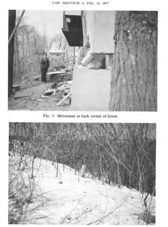
east of the first site. Landslide activity devel- The third example occurred along the banks oped in the narrow strip of land between the of the Ottawa River at the village of Wendover, highway and the Ottawa River. Figure 2 shows Ontario, about 16 km east of the slides at
622 CAN GEOTECH. J VOL 14, 1977
J
> -
I
-
FIG. 4. Highway alignment monument after 20 years at crest of slope.
Cumberland. The slope of the river bank was partially completed house and gives evidence not quite as steep as at Cumberland. Move- of both horizontal and vertical movement. ments were initiated by water spilling from In these three examples, the movements an incomplete roof drainage system at the were associated with definite cases of unstable front of a house. Although no dramatic slope slopes and took place over a relatively short failure resulted, substantial movement did oc- time span ( a few days). Near the first example cur and the bank was very close to the point on a seemingly stable slope, there is a highway of total collapse. Figure 3 shows the results of alignment monument situated near the crest of the movement at the back corner of the a clay slope. Figure 4 shows the condition of
NOTE
H O R I Z O N T A L D I S T A N C E , m
S L O P E M O V E M E N T . c r n
Fro. 5. Measured movements at slope G-I.
the monument about 20 years after its installa- tion. Some long-term movement is evident, but no other signs of instability were noted on the slope below.
Inclinometer Measurements
In 1968, six inclinometer tubes were in- stalled at three locations in the Ottawa area, in steep slopes adjacent to slopes that had landslide activity. The precise location and description of the inclinometer installations have been reported by Mitchell and Eden (1972) along with the measurements made
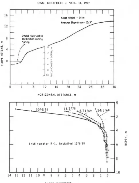
over the first three years. Very briefly, two installations (G-1 and G-2) were located along Green Creek, two (R-1 and R-2) were located on the banks of the Ottawa River at the former Rockcliffe Airport, and two (B-1 and B-2) were located along Breckenridge Creek. Sub- sequent to the 1972 paper, both installations along Breckenridge Creek were disrupted by slope movements. Installation G-2 along Green Creek has also been destroyed by landslide activity. Readings have been taken occasionally on the three remaining installations (G-1, R-1, and R-2). Figures 5-7 show the inclinometer
624 CAN. GEOTECH. J. VOL. 14, 1977
-
Slope He~ght = 14 m
Average Slope Angle
-
25.5'--
-
-
Ottawa Rlver Actlve
Ice Eros~on durlng
-
Spring
i_q)
0 E:
Y 2 $ Y - 02
---
4 ; 6 2 8 ? l o2
I I I I I 0 4 8 12 16 20 24 28 3 2 36 H O R I Z O N T A L D l STANCE, m I I I I I I I I O -, 3014176 1315175 k g / 1 1 / 6 9 0\2413169-
w4*-.<<*
\b4-o. lo<-
'w;?
\
+
\A
- 44
j
I n c l i n o m e t e r R - 1 , I n s t a l l e d 1 2 / 6 / 6 8 - 6bl
3 O LLA
-
\I
0 2 s C n.::
1 0 1 4 1 3 1 2 1 1 1 0 P 8 7 6 5 4 3 2 1 0 S L O P E M O V E M E N T , c mFIG. 6. Measured movements at slope R-1.
measurements made at these three sites from been steadily eroding; this is evident from the
the date of installation in 1968 to April 1976. apparent acceleration in rate of movement.
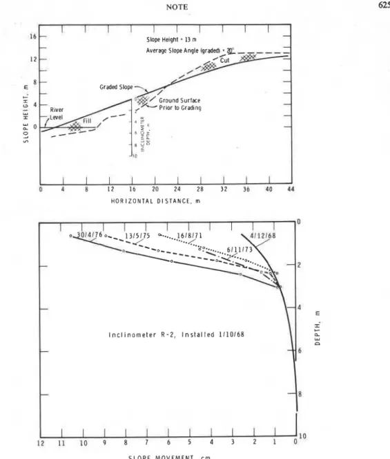
Because of difficulties in maintaining a precise Slope R-2 (Fig. 7 ) was graded in 1968 as part
reference in a horizontal plane over a period of slope protection measures to protect a large
of years, the absolute accuracy of any one hangar structure. Most of the movement is
measurement in the inclinometer tube is prob- taking place in the fill placed on the lower
ably no better than i=1 cm. Horizontal move- part of the slope. As described previously
ments are computed assuming the bottom of (Mitchell and Eden 1972), the movements
the tube to be stable. occur in early spring when the groundwater
Slope G-1 (Fig. 5) located along Green table is high.
Creek has shown progressive movement to a
depth of 4 m with a movement of about 1 Mud Creek Bridge
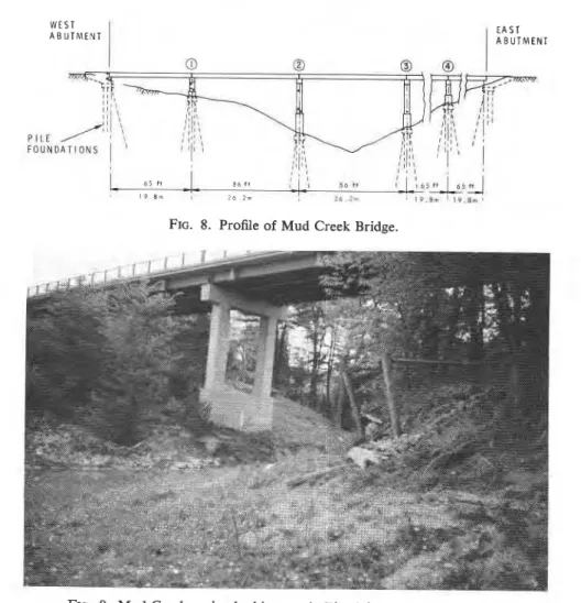
cm/year at a depth of 1 m. The steep portion The Mud Creek bridge spans a V-shaped
NOTE I I I I I I I [ 1 I 16 Slope Helght = 13 m 1 2 Graded Slope b- River I t b O r In z2 :u 8 V o L I I I I I I I I I I 0 d 8 1 2 16 20 2 4 28 3 2 36 4 0 P4 H O R I Z O N T A L D I S T A N C E , rn S L O P E MOVEMENT, c m 1
I
1 I I I I 0-
-
FIG. 7. Measured movements at slope R-2.
I n c l i n o m e t e r R - 2 , I n s t a l l e d 1110168
--
-
long and is supported on five piers, each pier being founded on end-bearing steel piles driven to rock. Figure 8, a profile of the bridge, shows the profile of the ravine along the bridge align- ment; Fig. 9 is a view of the ravine at the bridge site. Measurements have been taken of the convergence of the bridge piers since 1959 (Bozozuk 1976). Sixteen years of measure- ments have indicated
a
convergence of nearly5 cm. Specifically, between 1959 and 1973 the convergence between the west abutment and pier 1 was 0.70 cm; between piers 1 and 2 it
6
- 8
was 1.77 cm; and piers 2 and 3 converged by
1.61 cm. The actual soil movements were probably more than these amounts, as all piers were supported on end-bearing piles with two rows of batter piles to resist lateral movement. The Regional Municipality of Ottawa-Carle- ton installed a major high pressure water main through the ravine immediately south of the bridge. In April 1973 a rupture occurred in a trunk water main located on the east slope of the ravine. The precise cause of the break was difficult to determine because of construction
626 CAN. GEOTECH. J. VOL. 14, 1977
A B U T M E N T
I
I
I,'6 5 f f 8 6 I f a I I , 8 0 1 ,
I 9 8 m I 2 6 . 2 m I ? b I - ' I*.&, ' 1 V . U m .
FIG. 8. Profile of Mud Creek Bridge.
FIG. 9. Mud Creek ravine looking south. Pier 3 in centre of photograph.
activities in the installation of an underground telephone duct system. One explanation ad- vanced was movement in the slope.
Possible Mechanism of Creep
Previous studies at specific landslides in the Ottawa area have revealed that landslides take place during periods of high groundwater levels and when there is a supply of surface water available. The availability of water satisfies the dilatancy resulting from shear strain in the fissured clay. The strength behavior of the fissured crust has been shown to be pre- dominantly frictional shear resistance at low levels of normal stress and a concept of a curved failure envelope has been advanced (Eden and Mitchell 1973). Such a concept would explain the observation of numerous tension cracks and other evidence of movement
and the variation in geometric form observed in the landslides.
The influence of small changes in ground- water level can be illustrated by the results of a special drained test reported by Mitchell and Eden (1972). This was a stress controlled drained test on a sample of fissured clay from
the Rockcliffe site (inclinometer R-2). The
specimen was loaded incrementally to 90% of its anticipated failure load. A change in groundwater level of 0.5 m was simulated by increasing the back pressure on the drainage system by 5.49 kPa or 0.56 m of water. In 1 min the specimen strained 0.4 mm. When the back pressure was returned to its former level the strain stopped and no further axial deformation was observed during the next 2-min period. The process was repeated for several cycles until the axial strain reached
NOTE 627 3.5% without failure. This test demonstrated
that shear strain could be induced by small changes in water pressure in a fissured clay specimen under a significant level of shear stress.
It is suggested that this process is prevalent in steep slopes, and that movements coincide with periods of high groundwater level.
Conclusions
Evidence has been presented to indicate that sheep clay slopes are subject to significant movements that extend to a considerable depth in a fissured clay crust. The inclinometer measurements suggest the movements extend to a depth of 4 m and that this depth is dependent to a large extent on the geometry of the slope. The movements do not seem to be of a con- tinuing nature but take place when ground- water levels are high. The amount of move- ment each year is appreciable and must be considered when attempting construction ac- tivity close to clay slopes.
Acknowledgments
The assistance of colleagues in the Geotech- nical Section in slope stability studies is acknowl- edged. Particular acknowledgment is due to a former colleague, Dr. R. J. Mitchell of Queen's University, who initiated the program of inclinometer measurements. This paper is a contribution of the Division of Building Re- search. National Research Council of Canada. and is published with the approval of the Director of the Division.
B o z o z u ~ , M. 1976. Mud Creek Bridge foundation move- ments. Canadian Geotechnical Journal, 13, pp. 21-26. EDEN, W. J. 1975. Mechanism of landslides in Leda clay
with special reference to the Ottawa area. Proceedings, 4th Guelph Symposium on Geomorphology, University of Guelph.
EDEN, W. J., and MITCHELL, R. J. 1970. The mechanics of landslides in Leda clay. Canadian Geotechnical Journal, 7 , pp. 285-296.
- 1973. Landslides in sensitive marine clay in Eastern Canada. Highway Research Board Record No. 463, pp. 18-27.
MITCHELL, R. J . , and EDEN, W. J. 1972. Measured move- ments of clay slopes in the Ottawa area. Canadian Jour- nalof Earth Sciences, 9, pp. 1001-1013.