Publisher’s version / Version de l'éditeur:
Vous avez des questions? Nous pouvons vous aider. Pour communiquer directement avec un auteur, consultez la
première page de la revue dans laquelle son article a été publié afin de trouver ses coordonnées. Si vous n’arrivez pas à les repérer, communiquez avec nous à [email protected].
Questions? Contact the NRC Publications Archive team at
[email protected]. If you wish to email the authors directly, please see the first page of the publication for their contact information.
https://publications-cnrc.canada.ca/fra/droits
L’accès à ce site Web et l’utilisation de son contenu sont assujettis aux conditions présentées dans le site LISEZ CES CONDITIONS ATTENTIVEMENT AVANT D’UTILISER CE SITE WEB.
Technical Memorandum (National Research Council of Canada. Division of Building Research); no. DBR-TM-27, 1952-12-15
READ THESE TERMS AND CONDITIONS CAREFULLY BEFORE USING THIS WEBSITE.
https://nrc-publications.canada.ca/eng/copyright
NRC Publications Archive Record / Notice des Archives des publications du CNRC :
https://nrc-publications.canada.ca/eng/view/object/?id=da43956d-f071-4fb0-9543-c6d1868b1ad9 https://publications-cnrc.canada.ca/fra/voir/objet/?id=da43956d-f071-4fb0-9543-c6d1868b1ad9
Archives des publications du CNRC
This publication could be one of several versions: author’s original, accepted manuscript or the publisher’s version. / La version de cette publication peut être l’une des suivantes : la version prépublication de l’auteur, la version acceptée du manuscrit ou la version de l’éditeur.
Access and use of this website and the material on it are subject to the Terms and Conditions set forth at
The Associate Committee on Soil and Snow Mechanics is one of about thirty special committees which assist the National Research Council in its work. Formed in 1945 to deal with an urgent wartime problem involving soil and snow, the Committee is now performing its intended task of co-ordinating Canadian research studies concerned with the physical and mechanical properties of the terrain of the Dominion. It does this through subcommittees on : Snow and Ice, Soil Mechanics, Muskeg, and Permafrost. The cセ mittee, which consists of about fifteen Canadians
ap-pointed as individuals and not as representatives, each for a .3-year term, has funds available to it for making research grants for work in its fields of interest. In-quiries will be welcomed and should be 。、、イ・ウウセ、 to: The Secretary, Associate Committee on Soil and Snow Mechanics, c/o The Division of Building Research, National Research Council, Ottawa, Canada.
This publication is one of a series being produced by the Associate Committee on Soil and Snow Mechanics of the National Research Council. It may therefore be reFroduced, without amendment, Frovided that the Division is told in
advance and that full and due acknowledgment of this publication is always made. No abridgment of this report may be published without the written authority of the Secretary of the A.C.S.S.M. Extracts may be published for purposes of review only.
PROCEEDINGS OF THE
SIXTH CANADIAN SOIL MECHANICS CONFERENCE
WINNIPEG, DECEMBER
15
AND16
11952
TECHNICAL MEMORANDUM NOo
27
Ottawa
TABLE OF CONTENTS Page Noo Foreword Session or December 1$2 1922 1 Section 1 Section 2 Figo 1 Fig0 2 Fig..
3
Section3
Introductory Remarks by RoFo Legget
Source and Nature of the Regolith in the Various Landscape Areas or Southern Manitoba by JoH o Ellis and LoEo Pratt The Soil Prorile as the Upper Portion of
the Regolith
Physiographic Regions and Landscape Areas
Surrace Geological Deposits and Underlying Rocks
Corrosion and Erosion by Winnipeg Soils by Jc Sill 2
3
18
19 20 21Section
4
Vertical Ground Movements by Ao Baracos and 00 MarantzFig., 1 Multi-rod Vertical Ground Movement Gauge Fig .. 2 mオャエゥセイッ、 Vertical Ground Movement Gauge
Modiried ror Roadway
29
33
34
Fig.,3
Pig ..4
Section5
Fig. 1 Fig. 2 Fig.3
Fig ..4
Telescoping Vertical Ground Movement
Gauge
35
Observations of Vertical Ground Movements
36
Fbundation Movements on Highly PlasticClays by BoBo Torchinsky
37
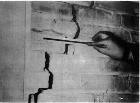
Typical effect of difrerential movement.
42
Typical orack resulting from differentialmovement.
42
Foundation movements or Regina College
Gym.,
43
Relation between water content and
Fig"
5
Figo
6
Fig"
7
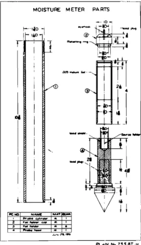
Sketch of neutron moisture meter o
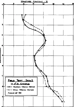
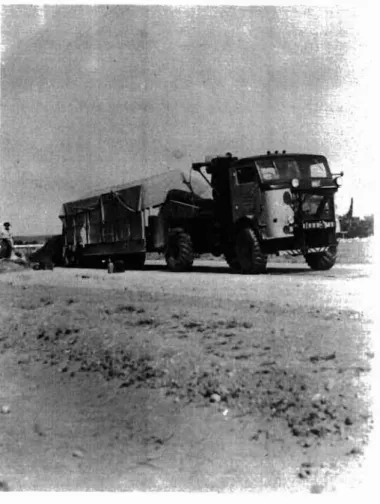
Neutron moisture meter field calibration Comparisons of water content profiles as determined by neutron meter and by oven drying ..
44
44
45
Figo 8 Section 6 Section 7 Fige 1 Fig.. 2Water content comparisons before and after flooding0
Soil Problems Connected with Foundations for Basementless Houses by Fo Lionel Peckover
The Sisson Earth Dam by Do F .. Coates General layout of the Sisson main dam..
Typical sections of the Sisson main dam.
45
46
52
58
59
Session of December 1691952
Section8
Figo 1 Figo 2 fセNァッ 3 Figo4
Figo5
Fig" 6 Fig"7
Fig" 8 Fig .. 9The "Foundation" Vane Tester for
Measuring In-situ Shear Strength of Soil by N.D .. Lea and BoDo Benedict Photograph of the "Foundation" Vane
Tester 0
Details of vanes.
"Foundaci.on" vane tester field gr-aph,
Table of vane test results from various pro jectso
Comparison of shear strength from several methods of testing セセ Sault Ste" Marie .. Comparison of shear strength from several
methods of testing セM Contrecoeur"
Comparison of shear strength from several methods of testing -- Nicolet
Typical shear strength vSo overburden curves"
Correlation of S2 - Sl ratio to liquid
P2 - PI limit" 60 70
71
7273
74
75
75
7778
Section 9 Fig 0 1 Fig. 2 Fig. 3 Figo 4 Fig. 5 Fig. 6 Fig. 1 Fig. 8 Fig. 9 Section 10 III -Page No. Load Testing Program of Ontario
Department of Highways by MoM. Davis. 19
Tractor-trailer unit. 83
Modification to trailer using I beam. 83
The plate set up for test. 84
Density test on subgrade. 84
Cone-bearing test being performed on
sUbgrade. 85
Waxing undistrubed specimen taken in
C.B
.a,
mould. 85Pattern of bearing recovery for 1950
season. 86
Pattern of bearing loss and recovery for
1951 and 1952 seasons. 81
Curves of design formulae o . 88
Discussion on Proposal for Canadian Standard on Identification and
Description of Soi190 89
Section 11 Secti..>n 12 Appendix A Appendix B
Discussion on the Foundation Section of the National Building Codeo
General Business
List of those present at the Sixth Annual Canadian Soil Mechanics Conference. List of Canadian papers for third
International Conference on Soil Mechanics and Foundation Engineering, Switzerland 19530
91 93
Appendix C Account of the Sixth Canadian SolI Mechanics
Conference from "The Precambrian", pages 28-30, January, 1953.
Foreword
This is a record of a conference of most of the active Canadian workers in the field of soil mechanics held in Wlnnipeg, Manitoba, December
IS
and 16,1952.
TheConference was sponsored by the Associate Committee on Soil and Snow Mechanics of the National Research Council. About 110 persons from all parts of Canada attended the Conference. A list of those attending is included as Appendix A of these proceedingsc
On December
15
meetings were held in theEngineering Bullding of the University of Manitoba at Fort Garry. On December 16 the conference met in the Manitoba Government Building, Broadway and Osborne Sts., Winnipeg. The material contained in Sections 2 to 6 were presented on the first day, the remaining sections on the second day. Dean A.E. Macdonald was chairman of the morning session of December
15
(Sections 2 and3);
in the afternoon ofDecember
15
(Sections4, 5,
and 6) Prof. W.F. Riddell was chairman. Dean R.M. Hardy was chairman of Sections7, 8,
and Q held in the morning of December 16 and Mr. ReF. Legget
was chairman for the remaining portion of the Conference. The Associate Committee on Soil and Snow Mechanics appreciates the assistance given in arranging the Conference by a committee in Winnipeg headed by Dean A.E. Macdonald. Thanks are also extended to the University of Manitoba for the use of the conference room, for the luncheon provided
on December
15
in the University cafeteria and for helpfulness of the staff of the University Soil Mechanics Laboratory in directing a tour of this laboratory. The accommodation on the second day provided by the Department of Works andHighways of the Province of Manitoba is gratefully acknowledged. Acknowledgement is also due the City of Winnipeg, Manitoba
Department of Works and Highways and local boring contractors for the display of special boring and sampling equipment on December 16.
The Committee also wishes to thank Mrs. P. Convey of the Winnipeg office of Technical Information Services of the Councik Her assistance as secretary to the Conference was greatly appreciated.
SESSION OF DECEMBER 1$, 19$2 Section 1
Introductory Remar!s by Ro F o Legget
In welcoming the delegates to the Sixth Canadian Soil Mechanics Conference Mro R.Po Legget stated that the purpose of the meeting was to promote discussion in the
field of Soil Mechanics and Foundation Fngineering. He remarked on the number in attendance and was very gratified at the steady increase over the years. He extended thanks on behalf of the Conference as a whole an? of the Associate Committee of Soil and Snow Mechanics to Dean A.E. Macdonald of the University of Manitoba for the work that his Committee had done in arranging the meeting and for "the hospitality of the University in allowing the Conference to be held in the Engineering Building.
Mr.
Legget drew the attention of the cッョヲ・イセョ」・ to two familiar colleagues Whose absence was sure to be noticed this year. They were Mro J.M. Fairbairn who passed away a few months ago and Mr. I.Fo Morrisonwho is confined to his bed after a heart attack.
Mro Legget then introduced Dro A.HoSo Gillson, President of the University of Manitoba.
President Gillson welcomed the Conference on behalf of the University and expressed his hopes that the meeting would be a success.
Mro Legget then introduced Dean Macdonald who was Chairman of the Conference for the morning of December 1$0
Section 2
Source and Nature of the Regolith in the Various Landscape Areas of Southern Manitoba
by JaH. Ellis and LoE. Pratt (presented by JoH. Ellis) Introduction
As a soil scientist, I appreciate very much the honour of being invited to present an outline of the "soils of the region" to this Conference. I would like first to bring to your attention the fact, however, that if engineers and soil scientists are to meet on common ground, we should attempt to reach a common understanding of the term" soils". It is imperative that we differentiate between the general term "soil", as commonly used by engineers for inert "earth material" with which they are concerned in the construction of earthworks or as a load-carrying base, and the specific term "soils", as used by soil scientists, agronomists, and biologists, for the dynamic natural objects, developed in
the upper portion of the regolith, that are modified by the biological communities which these objects contain and
support.
From a pedological (Le. soils) viewpoint, "Soils are the product of climate, and may be defined as natural dynamic objects, made up of organic and inorganic materials, living organisms, and the products of their reaction and interaction; formed at, and only at, the surface of the earth, キャセイ・ the atmosphere and hydrosphere (climate) come in contact with the lithosphere (inorganic セゥョ・イ。ャウIL under the influence of the biosphere (organisms)".
Soils are dynamic not static; they progress from youth through maturity to old age. The chief factor in their formation is soil climate. Morphologically, mature soils
(which in this latitude may be up to
4
or more feet in depth)have:-(i) a surface or "An horizon of maximum we athering of the soil minerals, but which, as in the case of grassland soils, may be also the horizon of maximum accumulation of organic matter;
(ii) a lower, sub-surface or "Bit horizon.ll which may be either a horizon of illuviation and colloidal accumu-lation, or a transition horizon between "A" and "Cit; and
4
-(iii) a nC l" horizon which is the more or less unaltered, or only slightly altered, substratum or "sub-soil" below the soil or "solurnlto
These soil horizons may be recognized by differences in colour, texture, structure, consistency, intrusions,
concretions, reaction, and numbers of organismso As the effects of life, organisms and climate fade out with increase in depth from the surface, so the soil-forming processes fade out, and the soil profile (which is the result of the soil-forming
processes) grades into inert mineral material or unconsolidated mantle rock, the characteristics and nature of which are
determined and influenced by geological rather than by pedolo-gical (ioeo soil) processes (Fig o 1)0 FUrthermore, when inert materials devoid of organic matter and of soil horizons are exposed at the earth's surface, (as in the case of moving sand dunes), such materials are not considered (pedologically) as soil but merely as "skeleton"*.
In contrast to the concept outlined above, the concept which appears to be held commonly by construction engineers is
that all earth materials that constitute the unconsolidated mantle rock may be referred to as "soil" even if such materials occur
40
feet below the soil profile. This is due, no doubt, to the fact that engineering interest in earth materials centers around the physical properties of the mantle rock or regolitp itself, and not primarily on the soils developed on and at its surface. Fbr example, in excavation work セ、 earth-fills, the soil profile is generally only a fraction of the mass of earth materials involved, and the footings of buildings of any size generally extend into the substrata well below the soiloConsequently, it is quite natural that engineers, who are concerned primarily with physical properties, should have overlooked the morphological, chemical, and biological soil profiles, and the interdependent and essential biological communities, which are destroyed whenever soil is removed and the underlying earth is exposedo
*
Mineral fragments of fine texture but devoid of soil horizons are classed by some soil scientists as "regosol"; if however, the fragments are coarse, gravelly, and stony, they aredesignated as "lithosol". Geologically, r-eg oso I s , lithosols, soils and the unconsolidated mantle of earth materials lying between soils and the underlying consolidated rocks are
To provoke discussion and to aid in arriving at a solution, we might even propound the question, "If we use such standard terms as 'earth fill' and 'earth dams' in referring to certain types of earth-work construction, and if we apply certain physical tests to earth materials so used, why should we refer to such tests as 'soil mechanics'? Should
we
not be consistent and state that we areinvestiga-ting the mechanics (or physical properties) of "e arth" material s (i. e. the regolith) which in this case we are, rather than state we are studying "soil mechanics", which in this case we are not?"
I leave the answers to you and, (because an outline of the parent materials of soils, rather than an outline of the genetic solIs themselves, provides a proper background for discussion of construction problems presented by the regolith), I turn from a discussion of soils, to an outline of the source and nature of the surface geological deposits in the various landscape areas of Southern Manitoba.
The Ance stral Material of the Mantle Rock in Southern Manitoba The rock formations in Southern Manitoba (former outcrops of which were the ancestral material of the present regolith or mantle rock) are outlined in summary form in Table No. I.
This table shows the characteristics of the rock formations, the lithology of the geological formations, and
the contributions made to the present regolith by former outcrops of the respective rocks. We are indebted to geolo-gists for the nomenclature of these rocks and for the
contribution they have made to our knowledge of these ancestral materials. However, period and rock formation names used by geologists to designate the age of rocks are of little meaning
to us as engineers and soil surveyors. From our point of view, it is the ュゥョ・イ。ャッァゥ」。ャセ the chemical, and the physical nature of the rocks (i.e. their lithology) that are important, rather than the few scattered fossils they may contain and by which the age of rocks is determined.
(1) Contributions Made by Ancestral Rocks to the Regolith The ancestral rocks have affected the texture, the mineralogical composition of the mantle rock, and the altitudes at which the regolith is found.
(a) Texture and Mineralogical Composition. - The regolith in Southern Manitoba has been derived from ancestral rocks of varied types. Through glacial action
(i) the granitoid, gneissic and schistose
rocks of the Laurentian Shield have yielded boulders, cobbles, gravel, sand and rock flour;
Table No. 1 - CliA.iU,CTZRISTICS OF ROCK FGRl'il.nON INsoutheセin J:'LulITOoA
(tormer outcrops or d1sintewated residues of v'ifch (in varying degrees) nov form theイ・セッャゥエィ or mantle rock, and the)
(parent material of Hmitoba soils. )
Geological PBriOOS
-RockFormations* LithologY*
Occurrence of Salin!ty IIithin These :
Fcrmatdonc Where They NOli Oocur as : Contributions Underl:ring Rocks : to the Regolith I
Clayandplat}" fraG1Jl8nts of shal.:.:,
:
: Clay
:
Well water varies, fairly baed in ; upper hard Shales.
:Mottled shales and ligru.te bedas Well waters sometimes mo::lerately highinsoluble salts.
:L1ght-grey hard siliceous :8hale--fisslle ..
:
;Soft greenish shale that slakes: Water usually high in sol Me salts.: Clay' :inwater.
,
:Greenish-grey sandstone ....hich : Artesian and vell waters moderately: Sand rveatber-e to a yellow or rusty high in soluble salts.
socdcr , Riding
Mountain:-(B) 0daDah phase
(A) M1.llwood phase
,TERTlI\RY PEIlIOD
Turtle Mountain
-:: Clay, lime and.
: benton!tic c1s7. I , :) I) : )Clay,acidclay, セ)bentonitic 01a7, ; ; ) gypsum and other : : )sulphatee, ; :)llJlIoD1t<J.
,
Notrecorded.
:
zVery dark grey or black" non" : calcareous ,」。イ「。ョ。」・ッオウLセアゥァ
: shale containing narrow bands : of bentonito 1n lower portion.
,)
: )Pyrite and selenite cryetcils are : )abundantespecially in Pembin'\and
: )Mordenbeds. Wellwater very high I)1n sulphates and may contain some ; : )chlorides.
:Graycalcareousspeckled shale.:)
: - - - t }
:Dd.rk-grey, acid shale. s )
,
:Grey shale with white calcar-:eous specks and narrow beds of ; rLtreeet.one and ofbentonite. (B) Boyne bods
(A) .Mordsn bods Favel
Vermilion Hi
ver:-(e) Pembina bods
: Redshale and gypSum.
:
: Red.to brown shales andred : ar,gillaceous sandstone. Ashville Swan River セJUlWlSIC p:;:rmlD (e) SUMance (B) CypeuI:: (A) Spearfish : ,MISSISSIPPIAN PE!!I!Il Unnamed
:D.aokgrey shale containing lime; Pyrite and selenite crystals present: Clay,sand,gypsum : :and samy beda ; : am limonite.
: ,
:Variable; sandstone shale and. :Sandstone high in soluble sa1.te. : 5.md... : low- ,{l'ade coal.
; ;)
セ)Glduconitic sandstone, :) s )
: )Green shale, shaly limestone, : )i1a.ny beds of msum and anhydrite :)Clay,reddisb :)and gypsum, : ) occurparticularly in lover :)clay,red 'sa.ndT
: )portions.One of the salt water : )clay,sand, tine : )horizons encountered in the Neepawa : ) sand, lime and : )brine veIl W'a3 inthe Sundence : )gypsum. : )formation. :)
:) :)
: Grey, buff and. cream. colored Outcrops not:moW. : limestones (oil.!). :DEVONIAIl PERIOD Manitoban W1nn1pegose.n ElmPoint Ashern : : : UpperーッイエゥッョセMケ。ャャッキゥウ「M「イッキョZI
J dolomitic limestone and dolo- :) : stone; yellovi5h-grey thick- :)
: bedded dense limestone;Lover : ) Scattered beds of 8,ypsurn and Jpcrtd.cn-..l imes tone, ugillaceoU3) anhydrite occur throughout : anddolomitic limestone, ani セ )Devon1an strata. Salt water
: shale. : hm.sstruckatbaseof Devonian
: )at Neepawa.. Surf'ace dopes!ts : Dolostone : )of gypsum occur at Gypsumville
: Jebcve the SUurlan formations : Yellowish-grey -nnely granulu:) • : limestone. :)
:)
: Brick-red to gr-eyf sh-orange :) : argillaceous dolostone. : ) : r} ,) :) : )Limestone boul- : : )dara, cobbles and: : )pebbleSj Cal- : : Icer-eoue olay, I : )magnesium clay, S 1)red clay, fine :
; ) sand, gypsum.,. :) I) I) :) :) Yellowish-orange,massive, ;) ;) fossiliferous and finely crys-:) :) tailinedolostone. : ) : ) : FcaafLf.fer-oua fragmental, セ
l
e)finely crystalline and stc-o- : ) :セ : matolitic dolostone;bioatromal:) ;)
: reere, セセ 0)
Yellolo'ish-greycalcitic dol- : )Same bods ofセウ a.nnoccur, and :j\1Ln;Jstonc boul- : : os tono , fossiliferous with : )are b::licved toaavo been laid dcva : )ders,cobblss.mel :
: sandy and silty zones. ZIセ closed or partially closed. seas : )pebbles;Cdl.car- : : . . . : hn セゥャオイゥ。ョ times. The main brine : )eous clay,magnea-: : Grey:J.s?-ycllow crystalline : )horJ.zon at Neepeva is in Silurian :)tum clay, sandy t
fossUlferous haddad dolostone: )llJl1estone. : )clay,silt,sand :) :)Wldfine s _ .
Stonevall formation--grey ;) .) normal marine bedded dolostone:) ;) underlain by arenaceous and : ) : ) ailty shale and dolostone. : ) : )
: SILURIAN PERIOD ; Interlake Qrooup:" E B A ッセcian PERIOD : Stony Mountain Bcd River. Winnipeg
Limestone and dolomite chiefly:) pinkand/or grey in color. :)
: )Salt vater horizonsィ。カセ been Ught grey, buff, or cream : )reporied in Red River limestone colored limGstonc. : )and Winnipeg sa-ndstone.
:)
:)
:)
: Tlri.n beds of colorl,,;:ss,mostly :) : unconsolidated Mnd and d<1rk :) : grey splintery shale. :)
: )LLnestone boul- : :)dcrs,cobblos nai : : )pebbles,pinkish : )clay,calcareous : ) clay, magnesium ; ) clay, 1:J.mc. ;) : )Silioa sand. I) Non salina. : Volcanic, intrusive and meta- : : morphic rocks; gran!to, peg-: matH-o,grano-diorito and : quartz diorite with gneissic : andporphyritic equivalents; ; basalt, dacite,andosite, : : アセコゥエ・L greyvacke,gnelssesI
a.nd schists, ate. : PllE-CAlIBllL\N Basement Complex : Granitoid,,gneiss_; : oid, schistoso, : : .md.quartzitic : boulders, cobbles: : endpobbles; : silicic, feld- : : spathic,micaceous: : and f'erro-mag-: silicate sands, : rock nour,silt, : grey and f'crri-: ginous clay, <IIiCompiled t'rom;- Geo. Sur. Can., : limonite, etc.
Can.Dept. of Mines, Geo. Hap。UZZcセセTセZYLwwォoョ、XョLrNtNdNL 1945. Geo. Sur. Can., Memoir 174,Johnston,W.A., 1934. Mdn. Dept. Minos & Nat. Res., Pub. 49-1,kセイイL L.8.,1949. Man. Dept. rt1.nes&Nat Ros
Physiographic Regions& Landscape Area.s
:
r Nat.ur-e of Regolithor SurfacegeAセャッァゥ」。ャ LepCJslta*:
Dominant Minor
Drainage or GroWld
Hater Regime**
Zgャ。」セッMョオカゥ。ャ outwash. ; Eroded or rever-ked till
; Erodedor r wor-ked till :and stratifieddrift ,:Hウ。ョ、ケLァイ。カGセャャケL。ョ、 stony). );Shale till, andgl.aca o-); fluvial dep-isf ts as kames ): and other c-rtvash forms.
) ) ) ) ) : and stratified drift )
: (sandy,gravelly, and stony). )Ground-water at shallow )depths normal only in :
)glacio-fluvial depoedt.ejcr- : )in gravel lenses occluded : )in the till. Closed ; Idepresetcne are commonly·: )occupiedbylakes or lnter-: }mittent sloughs, ) ) )
l
セセセセセZイZセキ。Z[ャセセZ・ウL。oo セ :Eroded or rLセイォ・、 till,セ(sandy,gravllly and stony); : kames; andlocal lacustrine : sediments. : Boulder till : Boulder tn"'! :Boulder till I : Boulder till : Boulder till ): ) : Boulder till ): (g) Turtle Mountain (h) Brandon&Tiger Hills (f) Waskade Till Piain (d) Newdale Till Plain
(e) OxbowTill Plain 1. セsteZ。n UPL-JillUEGIOi'!;-セッイ」オーゥョ・ Hountedn
l
b ) Duck Mountain c) Ridingl10untain (1) Peaba na Hills (j) Clearwater-Manitou Plain : Boulder till : Boulder till: Local Lacuecrdne deposits ;
: and gld.oialouti./ash. :Shaletill,.mdreworked
:or stratifioo drift.
)Deltaf,c and Lacus-)trine sediments.
;2.セゥQェャiNZイqヲAイセ jpNZォセApNsjセゥ⦅セlセNᆳ
il.. Transi tiongl, Areas from
セゥセイNAセ ZエZッセQYェAセセセゥMMMM
(1) abr-upt. Transition
(a) Escarpment :
(1) Porcupineertn, Sect.LonjSou'lder- ti11,eroded (ii)Duck rit.n, Section )till; andwave-cut (iii)Ridill6 .ttn , Section )te;"rc..ces. {tv} Pembina Hills Section)
(2) Gr-adue.I 'I'r-ensita.on thr-ough
nee-rev breaks in Eecar-pment. (a) Svan Hiver Plain (b) Valley River Plain (3) Or-aduak Transition through
broaddepressions in Upland Region
(a) Lake Souris Basin ILacustrine and del-:taic sands and. silt.
:Gravelandsandy beach 'de-apoatt.ejehaj,e outcrop; res i-:duum and oo.Ll.uvaumj out.wash : fans, カ。ャャ・セセ trains, and
aoutwash deltas.
:Till and er-oded till; coarse :textured stra.tified drift, : beach deposits andrecent : alluvium.
: Dunes andaeal.Lan depoeft.e •
: :
:allO-off ra.pid due to slope;:
: gr-ound-va'ter-may be present: :inャゥNュゥエセイャ quantities in
: beachE;:ravdsduriJ'1i,moist : : seasons.
:
: Shallowde)t;l of ground-:water locallyat contaet.
: of sandy mant.Le and under-:lying till.
:Ground-lJater present at 4 : :to 6feet below surface(:).: :fluctuates acccrddng to
r season ,
(b) Upper Assiniboine Delta aDeep deposits of : lacustrineand del-:taic sands, silt, and : dunes.
:Silty ae011a1and lacuatrine:Ground-vater plentiful at edepoaft.s , :20 feet t!:) below surface.
:
: Ground-·Jater, aocumulates fat contaot of sand and : : substratainmoist S88.5ons.:
:t
I
セgイ。カ・ャ and sandybeaches; セgイッオョZGゥMGjqエ・イ errati'" : stream outwash and alluvium.:
sIeveea, alluvium, andnood-:GroUIXi-waternot」セョャケ
:plain depcsdt.s , rpresent inclay depoea.t.e , I
: Poor surface drainage • :Local sanddunes.
eLacuet.r'Lne and del-: talc fine aanda,
:Littoraland deltaic :deposits.
rteeplacustrine and :varve clays. (b) Central Lacustrine Plain
(1) Western Section (i1) Central. Section B. Lowland
Areas:-(al Lower Assiniboine Delta
(c)South-eastern Complex ; Sub-aquatic till, . Drift of var-Led origin,and : glacio-lacustrine and: textureセsand over till; :glacl.o-fluvia.l com- rgrave Landsand beaches;
epl.ex --lake tcrrecc , rpeat. and swamp.
.
;Variable, Jround-water: presentinsセゥNョ、ケ areas :and artesianwaterriSes cLocakl.y,
(d) Westlake Area :Till, lake eroded rBcaches ; strea:n outwa'\h, :till; coarse-textured: shal.y fans, and allUvium; :stratifieddrift and :peatandswamp. : Lscust.rine eedtnent.sc :
:Variable--aurfaoedrainage:
epoor ,
: Variable--Surface drainage
: poor.
(e) Interlake Area
(f) Sasketchewan llclta
:Till,lakeeroded tlll.;Bcaches, peat and rock ; coarse-textured stra-: outcrop.
: tifled drift andLao-u
ruat.t-Lnesediments.
• --! 1
:Silt and clay alluv- :Outcrops of stlny calcareous:Subject to periodic dnun-:ium,stream levee, and:tilL ; dation. swraceandinter-I
: peat. :n.;;].drainage pocr , I
(g) Northern Clay Area : Lacustrine clay. ; Peat and swamp, : Only about25% wll-. to : Laperfect.Iy-dr aancd , :Rock outcrop,granitic:Local Lacus'tr-i.nc eedtmcnt.s stepr-esai.one occucfed by at l Tl ,_ _ _ _ _ _ _ _..a-indyoutwash. :peat, swampsand Lalces. s , eLakes , •.. __ .• ...J.
* セj⦅セエZNエセ⦅qNヲ⦅TN・RセウNゥセNMbッオャ、・イ till (assorted and. stony); Eroded or r-ewor-ked till (more or less sor-ted or
r-esor-ted-vsandy, gravelly, and stony).
PNBセᆪ ..tQ.-Jl!!rt.a)"si.cJl-o.s.lli:.- Kames (sorted, COilrse セ[イ。カ・ャャケ dnd cobbly); othx out'Wash (sorted, gravellyand sandy).
l。N」セエ[セィjャ・ ⦅TNNセエNNᄃZ -(Stone-freo), lacustrine sediments sorted and sized, -- Dandy, イセゥャエ[セ or clayey; deltaio deposits (sorted and uniforllly sized, -- fine s3.ndy or silty); 'ooachos (30rted, andirregularly stratified gravel
and simd) •
•i.eolim、・[NjッNセセエウ[Mサsエ・ョ・Mヲイ・・IL dune sands (sorted and sized -- mediumtJ fine sand); Locss (sorted and sized--silty).
6
-(ii) the Paleozoic limestone and dolostone rocks or the lowland region have yielded calcareous and dolomitic boulders, cobbles, gravel, fine sand; light khaki, light grey, marly, and pinkish calcareous clays; gypsum, calcium carbonate, magnesium carbonate and the salts of saline springs; and
(iii) the Cretaceous rocks or the upland region have yielded grey shale-clay, bentonite, shaly fragments,
gypsum, pyrite, etc.
These rock derivatives, in varying proportions depending upon location, constitute the till or glacial drift that forms the initial covering of the rocks in Southern
Manitoba; and in turn the till of the upland region has
contributed the erosionally transported products subsequently deposited over the till in the Lowlands region.
(b) Altitudes and Topography. - The altitudes at which the regolith occurs in the various physiographic regions of Manitoba have been determined by the rock relics of former eroded landscapes. These relics now form the rock base on which the mantle rock or regolith (consisting dominantly of
transported deposits) is supported. Three examples may be
given:-(i) The Precambrian rocks of the Laurentian Shield have an altitude of approximately
1700
1+ A.SoLo at theManitoba-Ontario border, and from this point they dip westward below the waters of Lake Winnipeg and below the Paleozoic
limestones and do1ostones or the Interlake area.
(ii) A central region of Silurian dolostone occurs in the Interlake area which rises to about 950'+ AoS.L. This forms a height or land between Lake Winnipeg,
(714'
A.S.L.) and Lake Manitoba(814'
A.S.L.).(iii) The Western Uplands (1550i - 2500' A.S.L.) consist of a higher steppe or eroded rock shelr over which
glacial drirt was deposited in Pleistocene times. In this upland region a number of isolated shale hills or buttes (vizo Pilot Mound, Nebogwawin Butte), covered with only a thin mantle of drift, stand out in the till plains in striking contrasts to the long chains of morainic hills and the comparatively smooth undulating terrain characteristic or the region.
The rock base on which the regolith rests has thus influenced the relative altitudes of the surface deposits in the respective physiographic regions and landscape areas. A further point of interest is that the minerals or rock rragments from these eroded rocks have been intermixed,
transported and deposited, in most cases, far from their ancestral origin. Consequently, the effect they have had on the texture
and mineralogical composition of the regolith has been very marked and far-reaching.
CHARACTEIISTICS OF lOCK FORMATION IN SOUTHEIN MANITOIA
(I'ormer outcroJl'l or disintegrated residues of which (in varying deereea) now form the re,olith or manUe rock,UIClthe parent material of Manitoba soils)
セpBBBGB Qi・」ォBセ 'lDTIARY PERIOD TunleMountain CIIIlTACEOUS PE!UOD セH_I IUdinIMountaill: (8) 0d.aDIIIl. . . .
MotUed shales and JiInltebeds.
Greenish-erey standlltoDewhieh
weathen to a yellow or rust)' color.
Lilht-ere/ulf.M
.m-abale - •
セ .r8aIIaltT WWliIl TIl_ P. . . Where TIleT N_o-r
u VIIlIerI)'IDc Jtoeb Well waten sometimes
moderate-I)'high in soluble salta, Artesian and well waten moder-ately hilh in soluble salta. Well water varies, fairl)'
.oocl
in upper bard &hales.Clay.
SaDd.
Clay ud plab' InC-meats cdIIIa& (A) Millwood phase
Vermilion Rivers: (C) Pembina beds (B) Boyne beds (A) Morden beds Favel Ashville Swan River JURASSIC PERIOD (C) Sundance (B) Gypsum CAlSpearfish MISSISSIPPI PERIOD Unnamed DEVONIAN PERIOD Manitoban Winnipegosan Elm Point Ashern
Soft greenish shale that slakes in water.
Very dark grey or black non-calcareous. carbonaceous, acid shale containing narrow bands of bentonite in lower portion. Greycalcareousspeckled shale. Dark-grey,acid shale. Grey shale with white calcar-eous specks and narrow beds of limestone and of bentonite. Dark grey shale containing lime and sandy beds. Variable: sandstone shale and low-grade coal.
Glauconitic sandstone. green shale, shaly limestone, and gpysum.
Red shale and gypsum. Red to brown shales and red
argillaceous sandstone.
Grev, buff and cream colored limestones (oil ::t).
Upper portion - yellowish-brown dolomitic limestone and dolostone: yellowish-grey thick-bedded dense limestone: lower portion _ limestone. argrllac-eous and dolomitic limestone, and shale.
Dolostone.
Yellowish-grey finely granular limestone.
Brick-red to greyish-orange argillaceous dolostone.
Water usually high in soluble salts.
Pyrite and selenite crystals are abundant especiallv in Pembina and Morden beds. Well water very high in sulphates and may contain some chlorides.
Not recorded.
Pyrite andselenite crystals
present.
Sandstone high in soluble salts. Many beds of gypsum and anhyd-rite occur partrcu lar ly in lower portions, One of the salt water horizons encountered in the Nee-pawa brine well was in the Sun-dance formation.
Outcropsnot known.
Scattered bedsof セypDオュ and an-hydrite occur throughout Devoni-an strata. Salt water was struck at base of Devonian at Neepawa. Surface deposits of gypsum occur atGypsumville above the.' Silurian formations.
Clay.
Clay. acid clay. ben-tonitic clay. gypsum and other sulphates, limonite.
Clay. lime and bentonitic clay. Clay.•and, gypsum and limonite. Sand.
Clay. reddish clav, red sandy ria)', sand, fine sand,lime and ,::yp!'um
Limestone boulders. cobbles and pebbles: Calcareous clay, red clay. fine sand.
gyp-sum. SILURIAN PERIOD iョセャ。ォ・ Groups: D c
•
A ORDOVICIAN PERIOD Sian)'Mountain "'River PIla-CAMBRIAN Duement Ccmplel< Yellowish-orange, massive, fossiliferous and finely crys-talline dolostone.Fossiliferous fragmental, finely crystalline and stromatolitic dolostone; biostromal reefs. Yellowish-grey calcite dolo-stone, fossiliferous with sandy and silty zones.
Greyish-yellow crystalline fossiliferous sbedded dolostone. Stonewall formation - grey normal marine bedded dolostone underlain by arenaceous and silty shale and dolostone. Limestone and dolomite chiefly pink and!or grey in color. Light grey, buff, or cream colored limestone. r
Thin beds of colorless, mostly unconsolidated sand and dark grey splintery shale. Volcanic, intrusive and meta-morphic rocks; granite, pegma-tite. grano-diorite and quartz diorite with gneissic and por-phyritic equivalents; basalt, da-cite, andesite, quartzite. grey-wacke, gneisses and schists, etc.
Some beds of gyp.'um occur. and are believed to have been Iaid down in closed or partially closed seas in Silurian times. The main brine horizon at Neepawa is in Silurian limestone.
Salt water horizons have been re-ported in Red River limestone and Winnipeg sandstone.
Non saline.
Limestone boulders. cobble. and pebbles: Calcareous clay, magnesium cia)'. sandy clay, silt, 'and and fine sand.
Limestone boulders.
cobbles and pebbles; pinkish clay. calcar-eous clay, ma,nesium clay. lime.
Silica sand. Granitoid, gneissoid. schistose and quartz-itic boulders, cobbles and pebbles; silicic, feldspathic, micaceous and ferro-mapilicate sands. rock flour, silt, grey and ferri,inous clay, limonite, etc. C"",pi1ed from: Gen.Sur. Can., Memoir 239, Wickenden, R.T.D., 1945. Geo.Sur. Can., Memoir 174, Johnston, W.A, I.... Can. Dept of Mines,Gen.Map 850A, 1946.
Man. Dept. Minea • Nat. Res., Pub. 49-1, Kerr, L.B., 1949. Man. Dept. Mines" Nat. Res., Pub. 411-2, Baillie,A.D., 11151. II .... Dept. M,... Nat. Res., Pub. 50-I, Baillie. A. D, 1951. tセGZh M£.MO セサャW
8
-A study of the rocks involved is a first step in acquiring either an understanding of the earth materials used in the construction of earth works, or in an understanding of the textural セ、 mineralogical composition of the parent materials on which Manitoba soils have been developed.
Nature of the Regolith in the Respective Physiological Regions and Landscape Areas in Southern Manitoba
The southern half of Manitoba may be divided naturally into three major physiographic regions:- (1) The Western Uplands Region; (2) The Manitoba Lowlands Region; and
(3)
The Laurentian or Precambrian Region.On the basis of topography, altitude and native vegetative cover (viz. grass, aspen-grove, forest), these regions in turn may be sub-divided into landscape areas as
shown in the sketch map presented as Fig. 2 and outlined briefly in Table No. 2 and in the following notations.
(1) The Western Uplands Region
The Western Uplands Region is a region of active erosion. It presents different surface aspects and can be sub-divided into landscape area groups as
follows:-A. The Porcupine, Duck, Riding, and Turtle Mountain areas which are hilly, more or less morainic, and under forest cover; B. The Pembina, Brandon, and Tiger Hills
areas which are sharply undulating, somewhat morainic, and under grass and aspen-oak invasion; and
c.
The Newdale, Oxbow, Waskada and Manitou-Clearwater till plains, which are smoothly undulating areas of open ァイ。ウウャ。ョ、セ with or without local islands of aspen grove. The landscape areas in the Uplands Region have one feature in common, i.e., the prevailing surface deposits are glacial till with minor areas of glacio-fluvial deposits occurring in association with the till in various scattered localities.(a) Glacial セャNNNNNャャゥゥャャqNᄃNャNエウNセ - Except in the Manitou-Clearwater area where much of the drift is grey shale-clay till, fairly free from stones, and
5
to50
feet in thickness, the prevailing drift in the Western Uplands has the following characteristics:Drainalte or GrouDd Water Reltlme"
Ground-waler at shallow depths normal orily in glaeio-lIuvial deposits, or in gravel lenses occluded in the till. Closed depres-pied by lakes or inlermit-tent sloughs.
sians are commonly eeeu-Shale till, and glacio-II uvial
deposits as kames and other outwash forms.
Eroded or reworked till and stratified drift Isandy, gravelley, and stony). Eroded or reworked till and stratified drift (sandy, gravelly, and stony). Eroded or reworked till, (sandy, gravelly and stony); kames; and local lacustrine
sediments.
Giacio-lluvial outwash. Galeareous till, kames, and other outwash forms. Local lacustrine deposita; and glacial outwash. Shale till, and reworkedor stratilled drift. Boulder till Boulder till Boulder till Boulder till Boulder till Boulder till Boulder till Boulder till
(f) Waskada Till Plain Ie) Oxbow Till Plain (d) Newdale Till Plain
(g) Turtle Mountain (h) Brandon .. Tiger Hilb
(i) Pembina Hilb
Ij) Clearwaler-lIaDilou Plain
MAJOR PHYSIOGRAPHIC REGIONS AND LANDSCAPE AREAS; NATURE OF REGOLITH; AND GROUND-WATER REGIME IN SOUTHERN MANITOBA
PIl'-::-e
RqIou .... Nature of Rerollth or Surface Geolorteal Deposita'peAna DomiDaDt Minor
I. WESTERN UPLANDS REGION: (a) Porcupine Mountain
(b) Duck Mountain
(e) Riding Mountain
B.LoWLUIDAuAa:
(a) Lower AuinJboine Delta Lacustrine and deltaic fIDe sands.
CIIAN1'l'OBALOWLANDS
DJION:
(A) Ta.t...-ALAaAano..
UI'L&JlIIt'O Lowt.AJm:
(1) AbruptTranaitIon H。Iセエ
( I) PoreuDineMin. Sec.
(Ii) Duek""M1n.Sedlon
(w) Jtldina:Min.Sedlcm
(Iv) PemblinaHUb Sec.
(2)Gradual TruWticmthrou&h
IWTOWbreaks inEscarpment la) Swan River Plain (b) Valle, River Plain
(a) Gradual TruWtionthrou&h
broaddepreaionain Upland
セクN「 SoIub Buin
(b) Upper AuinJboille Delta
Boulder till, eroded till; and wave-eat &erraee.. Deltaic and lacustrine aedimena.
Lacustrine and dellai" 1AIId8 ...ut.
Deep deposita of lacus-trine and deltaic sands,
alt,anddunea.
Gravel and sandy beach de-poeita; shale oUlerop; resi-duum and <alluvium;
out-ZオMZ[Z、・ゥセケ trains, and Till and eroded till; coarse
lelrtured stratilled drift, beach depusita and recent alluvium.
Dunes and aeolian deposits. Siltyaeolianand lacustrine deposits.
Local sand dunes.
Run-olf rapid dueto
slope; ground-water IDa7 be present in limited quantities in beach grav-eb during moistIeUOIII.
Shallow deDth of
grouDCl-waler locally at <antaet of sandy mantle aad
1m-derlying till
Grand-walerpresentat .. to 8 feet below surface
(±). Fluctuates aeeord-ing 10season. Ground-water plentiful at 20 feet (±) below surface. Ground-waler, aeewnu-Iales at <antact of sand and substrata in moist
seasons. (b) Central Lacustrine Plain
(i) Western SedlOIl Littoral and deltaic
cIepo.tta. Gravel and sandy beaches; Ground-waler erratle.stream outwash and alluvl- ' um.
(Ii) Central Sedlon (c) South-easlem Comple>: (d) WestlakeArea
(e) Inlerlake Area
(I) Sas1ratchewan Delta II) Jlforthem Clay Area
Deep lacustrine and varve claya.
Sub-aquatic till, glacioo
lacustrine and glacio-lIuvial eomple>:-lake terrace.
Till, lake erodedtill:
eoarse-textured strati-lied drift and lacustrine sedimenta.
Till, lake eroded till, eoarse-telrtured
strati-Ileddrift and lacustrine sedimenta.
Silt and clay alluvium, stream levee, and peat. Lacustrineセャ。ケN
Levees, alluvium, and
llood-plain cIepo.tts.
Drift of varied origin, and lenure; sand over till: gravel and sand beaches; peat and swamp. Beaches; stream outwash, shaly fans, and alluvium; peat and swamp. Beaches, peat and rock outcrop.
Outcrops of stony calcare-ous till.
Peat and swamp
Ground-walernot
COIII-monly Preselllt in clay deposits. Poor surface drainage.
Variable, ground-water present in sandy ... and arlesian waler rises locally.
Variable-urface drain-age poor.
Variable-urface drain-age poor.
Subject 10 periodic inun-dation. Surface and in-ternal drainage poor. Only about 25% well-to
imperfectly-drained.
3. LAUJUDITIOff SHIELD
..aIOII:
V • ,astia&ed Rockoutcrop, granitic Local lacustrine sediments; Depressions occupied b:r till, sandy outwash. peal, swamps and lakes. lakes.
• セ 01Deposit:Boulder till (assorted and stony); eroded or reworked till (more or less sorted or resorted
-1Md7.gravell7, and stony).
GIIRe-,....1 Deposits: Kames (sorted,<Oar:egravelly and cobbly); other outwash (sorted, gravelly andsandy). a-riMDeposits: (Slone-free), Iaeustrines ediments sorted and sized, - sandy, silty or clayey; deitaic'depciiits
(8IIrtedand uniformly sized, _ flne sandy or silty); beaches (sorted, and irregularly stratified gravel and sand). Aeolilm Deposits: (Stone-free) dune sands, (sorted and sized-medium 10 line sand); Loess (sorted and sized-all\1'). UNotatiOlll re waler regime refer to soil prollles and their immediate substrata, rather than to deep-lying walers.
10
-(i) It is generally khaki-coloured or mottled calcareous till derived from limestones, dolomites and shale, in which granitic, gneissic, schistose and calcareous boulders, cobbles, grit, and in some cases shaley fragments, are embedded.
(ii) The till is assorted. It is generally of clay loam to loam in texture, but it varies in degrees of stoniness. (Boulders are generally more plentiful where the topography is morainic and where the finer separates have been removed by erosion.) It varies also in depth with
location, from less than 30 to more than 300 feet, and mayor may not have glacio-fluvial deposits as local associates.
(iii) The surface terrain varies from hilly (knob and basin topography) to gently undulating. Two types of relief occur. The first type consists of linear channels cut in former times by the waters from the melting continen-tal ice-sheet, and eroded still further in recent times by meteoric run-off waters. (The larger channels are now the valleys of the Assiniboine, QulAppelle, Minnedosa, Shell, Birdtail, Souris, and Pembina rivers. hッキ・カ・イセ some of the linear channels are geomorphic relics that carry run-off waters only at periodic intervals.)
The second type of relief is quite common and consists of numerous depressions or closed basins -- many of which contain lakes, ponds, intermittent sloughs and alkali flats. Here, the internal water regime varies with the topographical position.
(b) Glacio-Fluvial Deposits. - Various forms of coarse-textured erosional debris and glacio-fluvial deposits, derived from the till, occur as local islands in the glacial drift. These local deposits, which often serve as aquifiers, include:
(i) Internal lenses of gravel and sand occluded in the till and erosional debris sometimes observed embedded between different sheets of till,
(ii) Linear strips of gravelly, stony residue occurring along former stream-cut terraces. (The latter is common above the banks of the Assiniboine and the Souris rivers.);
(iii) Kames or isolated hills of gravel. (These are fairly common in the Tiger Hills and the Waskada areas, and in the Riding Mountains.);
(iv) Gravel and coarse sandy outwash in the form of undUlating plains (i.e. Marringhurst Plain and the Ellice-Archie Community Pasture);
(v) Gravelly deltas and fans around the margin of glacial Lake Souris;
(vi ) Gravelly hills and undulating areas of coarse outwash in the Riding and Duck Mountains. (Here the gravelly outwash is indicated by stands of Jack Pine.);
(vii) Modified or re-worked drift that has been sorted and acted upon by surface-moving waters.
(c) Lacustrine Deposits. - Deposits of lacustrine sediments in the Uplands Region are not common and are
generally of little importance throughout the region as a whole. The most important lacustrine deposit is found around Whitewater Lake, where a thin mantle of clay lies over the
till and covers an area (including the intermittent lake) of approximately 128 square miles.
In general, the regolith in the Western Uplands Region is relatively ウゥセーャ・N As structural and load-bearing material, the till is comparatively favourable, (except perhaps for local salinity in the imperfectly - drained sites). Acute problems on an extensive scale need not be anticipated, but there are the obvious problems that arise from local drainage, slope, and exposure. Salinity, however, as noted above, may be an important factor in depressional areas.
(2) Manitoba Lowlands Region
The Manitoba Lowlands is a region of deposition and accumulation and, because it is a catchment and deposition basin, the regolith here is complex and presents a number of problems that vary with site.
For present purposes, the landscape areas lying below the general level of the Uplands Region have been grouped
into two categories:
A. Areas that are transitional from the Uplands to the Lowlands; and
B. Areas within the Lowlands proper. A. Transitional Areas
The landscape areas that can be considered as transitional from the Uplands to the Lowlands or from the second to the first western steppe are of three
types:-(a) Areas of abrupt transition; (b) Areas of gradual transition through narrow breaks in the escarpment; and (c) Areas of
12
-(a) Areas of Abrupt Transition. - The Manitoba escarpment is an abrupt transition or descent from the Western Uplands to the Manitoba Lowlands. It
includes:-(i) The Porcupine Mountain section; (ii) The Duck Mountain section; (iii) The Riding Mountain section; (iv) The Pembina Hill s sect Lon ,
The terrain in these sections is varied, but all sections have more or less strong slopes and rapid runoff. The upper levels along their eastern exposure generally have thin deposits of stony till, but at lower levels wave-cut terraces and gravelly or sandy lake beaches form linear patterns on the slopes. On the lee or east side of these beaches sand strips are common. In contrast to the excessive runoff common to the steep escarpment slopes, these beaches tend to retard runoff and although the beach crests are well-drained, ground water generally accumulates at the contact of the sand and the underlying till, and the till adjacent to
the west side of the beaches is invariably imperfectly-drained. The escarpment is also channelled by steep ravines which, in many cases, have eroded into shale rock. Colluvium is common at the foot of the escarpment, and recent stream outwash fans, or deltas of shale and shale-clay, are much in evidence where the streams change grade as they issue from the ravines.
(b) Areas of Gradual Transition Occupying Narrow Breaks in the Escarpment. - The Swan River and the Valley Ri ver run through plains that may be considered as gentle slopes occupying breaks in the escarpment. These areas are designated in the sketch map (Fig. 2), as the Swan River Plain and the Valley River Plain respectively. These two areas were occupied in turn by ice-dammed lakes and later by bays of a common lake when the waters merged into glacial Lake Agassiz. "The initial floor of glacial drift around the margins of these valley plains has been profoundly modified by wave action, and that of the central portions has been covered by lacustrine sediments, alluvial deposits and stream overwash. Hence the regolith here is complex and variable in texture, depth, component strata, and internal drainage.
(c) Areas of Gradual Transition Through Broad
Depressions. - A broad depression that extends from Treherne to Neepawa forms a wide break in the continuity of the Manitoba escarpment. West of this lies the Upper Assiniboine Delta,
the apex of which is in the vicinity of Brandon. West of the Upper Assiniboine Delta, and lying in the depressional area between the Waskada and the Newdale till plains, is the broad plain formerly occupied by glacial Lake Souris. In these two areas, i.e., Lake Souris Basin and the Upper Assiniboine Delta, the regolith is of especial interest. A cross-section from west to east 1s shown in Fig.
3.
(i) Lake Souris Basin: This basin in the Uplands region was a catchment area for the glacial waters which flowed down the Qu'Appelle and the Assiniboine valleys when glacial ice was in retreat from southern Saskatchewan and southwestern Manitoba. This catchment area thus became a lake, the outflow from which escaped through Lang's Valley.* Figure
3
shows that the initial boulder till deposits of this somewhat depressed area are covered by highly porous sand and silt deposits.
Around the periphery of this area gravel fans are numerous at points where streams from the surrounding till enter the lake, and in the Deleau district, the
sandy deposits have blown into dunes. The sandy plain as a whole is an aquifier and, over much of the area, groundwater is common at a depth of about
6
feet. In wet seasons the water table rises so that water may be found at or near the surface in the central part of the basin adjacent to Oak Lake. Thus, although the surface may often appe ar dry, the lower part of the "so il profile"and the underlying substrata are both more or less under the influence of groundwater.
(ii) Upper Assiniboine Delta: The Upper Assiniboine Delta consists of deep deposits of sand interspersed with lenses of silt deposits. Lag-gravel, dune sand, and lee sand occur in sequence across this area from west to east. Nevertheless, sandy deposits dominate the surface and sand dunes (which cover a large portion of this landscape area) are well-known features. In some areas lake waters or wind have spread a mantle of silt over the sand. In some places the delta sand deposits are recorded as up to 200 feet in depth.' Groundwater generally is reached at about 20 feet and hence this sandy area is an im.portant aquifier or
water-storage area from which good groundwater can be recovered through drive-point wells. Although sandy surface
deposits are dominant both in the Lake Souris Basin and the Upper Assiniboine Delta, the water regime and vegeta-tive cover are different. The former is a flat sandy area with moist substrata, and moisture-loving plant species are common components of the vegetation. In the latter area, the sand deposits are deep, the surface tends to be dry or excessively drained, and the vegetation
consists of more drought-tolerant species.
-if- The broad eroded inflow channel to the northeast of the
Lake Souris Basin and the outflow channel to the southeast are shown in Fig. 2.
, "Glacial Lake Agassiz", by Warren Upham, Geological and Natural History Survey of Canada, 1890.
14
-B. The Lowlands Area
The lowland region lying east of the escarpment is characterized by an imperfectly-drained flat terrain and by surface deposits that are more or less sorted and sized.
The region as a whole was affected profoundly and differentially in glacial times by the advance and retreat of the continental ice-sheet, as well as by lake waters and icebergs. In post-glacial and recent times, the lacustrine plain has been
affected repeatedly by flooding and stream overwash. As shown
in Fig. 2, the lowlands region, which forms the basin of glacial Lake Agassiz in the southern portion of m。ョゥエッ「。セ may be
subdivided into four landscape areas:- (i) The Interlake and Westlake areas; (ii) The Lower Assiniboine Delta area; (iii) The Central Lacustrine Plain, and (iv) The Southeastern Complex.
(i) The Interlake and Westlake Areas. - The regolith in the Interlake and Westlake areas consists dominantly of lake-washed and re-sorted calcareous till. The surface is often stoney and, as the result of wave
action and undertow during inundation by glacial Lake
Agassiz, the terrain now presents a micro-relief topography of ridges and shallow depressions that run in a general north-northwesterly to south-southeasterly direction.
Gravel and sand beach deposits that mark former shore-lines are fairly common, especially in the Westlake area. These beach deposits are a source of
road ballast.
(il) The Lower Assiniboine Delta Area. - The regolith in the Lower Assiniboine delta area [Which lies east of the upper delta and at a lower altitude) consists of a thin mantle of fine sand lying over lacustrine clay and calcareous clay till. The surface deposits may be considered as loose, porous sand with a wet sub-strate and, as the result of local precipitation, high porosity, and seepage from the upper delta, groundwater accumulates above the contact of the sandy mantle and the underlying clay strata. This gr-oundweter- appears to have a slow drift in an easterly and north-easterly direction.
イセッイ・ッカ・イL the amount of gr-o un dwaber-, (and even its
presence or absence), varies with the precipitation in different years, but in moist seasons groillldwater is often found at between
4
to8
feet from the surface. Groundwater lime is also common. It may be seen in theintermediate and less well-drained positions as a marly coating on the particles and aggregates of the first foot depth.
(iii) The Central Lacustrine Plain. - The
central lacustrine plain should be considered as composed of two sections. Both have flat topography, but in the western section and adjacent to the escarpment, the till
and lacustrine clays are covered by a mantle of varied littoral deposits such as gravel and sandy beaches,
lacustrine sands, and deltaic silt. Also, where streams issue from the escarpment, thin fans of outwash-clay are spread over the lacustrine sediments. Hence the regolith in the western section is complex and varied with definite and abrupt changes in texture. Although the surface
appears flat, the terrain here has an eastern fall of from 20 to 10 feet per mile and the surface is traversed by numerous intermittent draws.
The central or main section of the lacustrine basin is the large expanse locally referred to as the Red River Plain. This section is flat. the overall fall to
the Red River (east and west) being in the neighbourhood of from two feet to one foot or less per mile and with
an average fall of less than one foot per mile from south to north. The flat topography, with only low micro-relief, combined with the widespread fine clay-textured deposits, results in slow surface drainage and in sluggish internal drainage. Prior to settlement, flat marshes and wet
meadows made up about 60 per cent of the area.
The regolith in this lacustrine plain has a varied profile. The basal deposits are boulder till with an irregular contact surface. The till is covered in turn with fine lacustrine clay, generally distinctly varved and of a tough consistency. Deep ditches reveal the presence of slickensides in the clay deposits. Thin bands of silt, fine sand, and sandy clay, which are again covered with lacustrine clay sediments, indicate temporary shallowing
and subsequent deepening of the lake waters in which these materials were deposited. In several places, straw-coloured silty deposits, that appear to have been carried in by
wind (probably between the times of lake subsidence and subsequent deep inundation) are met with. In the southern portion of the basin, silty deposits derived from the
Walhalla Delta have been deposited as a mantle over the lacustrine clay between Emerson and st. Jean. In the northern portion of the basin, calcareous straw-coloured fine sandy clay has been carried from the high-lime till of the Interlake area, and deposited as a tongue-like intrusion over the lake clay in a section extending from the Stonewall-Selkirk districts, through the site of the City of lHnnipeg and as far south as St. Norbert and La Salle.
16
-A further and unique form of complexity is encountered. Deep excavations may reveal varved clay,
(which was obviously horizontally bedded when deposited) that is now strongly foliated and contorted. In addition, conglomorated masses of till may occur as sub-aquatic morainic drift, or as occlusions within the distorted clay.
Intermixed sub-aquatic drift and lacustrine sediments are of local occurrence. These phenomena point to the gouging and distortion of the lake floor and to the deposition of ice-borne materials as the result of advance and retreat of the continental ice-sheet wi thin the Lake Agassiz waters. Some local unconformity of the regolith, as reflected in local pockets of silt, calcareous clay, and stones,
derived from till but embedded in clay deposits, may have been caused by icebergs.
As the continental ice and the glacial lake
finally receded, and ponding succeeded complete inundation, the inflowing streams deposited alluvium in broad sheets and, in many cases, levees were built up along the immature meandering stream channels. Thus, although the surface of
the regolith now appears flat and smooth, the regolith profile is extremely complex. It varies, not merely from place to place, but frequently from one point to another under the same building site. It is obviousa therefore,
that in the Red River Plain, the varied character and mixed texture of the regolith, the high plasticity of the lacustrine clay, the marked swelling and shrinkage of the clays with
changes in moisture content, the sluggish internal drainage, and the flat topography, imperfect surface drainage, and flooding hazard, here combine to present serious problems for consideration by construction engineers.
(iv) Southeastern Complex. - Lying east of the central lacustrine plain, and south of the Whiteshell Reserve, is an area that apparently served as a lake
terrace at one stage in its history. Sandy drift, with huge granitoid boulders, surrounded and underlain by calcareous clay boulder-till mark where one ice-sheet or ice-lobe rode over another. Sub-aquatic till, glacio-lacustrine and glacio-fluvial deposits were laid down here in a complex pattern. Later, in the lake-terrace stage, these materials were reworked and re-sorted into a
complexity of surface deposits to which we can make reference, but which cannot be dealt with adequately in this general
outlLne ,
(3) Laurentian or Precambrian Region
The Laurentian or Precambrian Region, lying east of Lake Winnipeg and north of the Southeastern Complex, is
unorganized and sparsely settled territory in which lakes, swamps, and erratic regolith deposits lie between strongly glaciated
outcrops of Precambrian rocks. The surface deposits that lie in the southern portion of this region in Manitoba are not overlooked, but they may be considered as outside the scope and purpose of
In the foregoing notations an attempt has been made to present a general outline of the following:
(i) The lithological composition of the ancestral rocks;
(ii) The source and nature of the mantle rock which now covers its ancestral relics in the
respective landscape areas; and
(iii) The dynamic forces that have been responsible for オセゥヲッイュゥエケ or variation, as the case may
「・セ of the regolith in southern Manitoba, in which (as "earth materials") engineers are
interested, but which (as the parent material of' "soilsl1
) also command the interest of soil scientists.
Discussion
Professor Baracos pointed out that in many respects the agriculturalist has pioneered the obtaining of information of soils which today is widely used by the engineer. It is in keeping with this pattern that Professor Ellis of the Department of Agriculture of the University of Manitoba gave
the opening paper at the first Soil Mechanics Conference to be held in Manitoba. Professor Baracos said that the extensive general data presented in this paper had given an insight to where and why soil problems arise in this Province.
ᆬセN Legget asked Professor Ellis for a definition of "soil". He stressed that engineers and soil scientists should be familiar with the terms used in each profession and mentioned
that references of the work of William Dawson and Sir William Smith used the term soil in much the same manner as it is used by modern engineers. In イ・ーャケセ Professor Ellis pointed out
that agriculturalists were not interested in soils only from an agricultural production point of view. He felt that this use of the term soil dated back to Cain, the first tiller of soil.
Mr.
Lea asked for a definition of I1till". He pointed out that the word till covered a very great variety of soil deposits. Professor Ellis replied that till is a material which was deposited by ice.Mr. McRostie asked how one should prospect for gravel three or four feet below the ground surface. Professor Ellis pointed out that soil mapping work usually include s only the top four or five feet. Sometimes gravel deposits are very apparent in the terrain. Some deposits are found accidently during well drilling operations. Dean MacDonald then thanked Professor Ellis for his very fine paper.
THE SOIL PROFILE AS THE UPPER PORTION OF THE REGOLITH PRINCIPAL SOIL HORIZONS and SUBSTRATA A B CONDITION
Horizon of maximum weathering:
ELUVIAL horizon in leached soils, and
ORGANIC accumulation in grassland soils.
Horizon of less intense weathering;
ILLUVIAl horizon - clay o-nd colloid
accumulation-in leached soilsI or
TRANSITIONAL horizon fram A ta C.
PEDOLOGICAL DESIGNATION SOIL PROFILE GEOLOGICAL DESIGNATION
t:
"
=-: セ セ..
I') "-I C1 Co
Ocr)Slightly altered parent material.
Decomposed rock materials,
or surface geological deposits generally
unat tere a by soil forming processes I but
geologically similar to the upper section in which the soil pro file was developed.
Substratum. if unlike Cセ (present or absent).
Consolidated rock. FI,C.URE.. SUBSTRATA or SUBSTRATUM ROCK REGOLITH or MANTLE ROCK ROCK セ
I:-'"
titPHYSIOGRAPHIC 9 50 r.f P. ':;"",theastern CompleK LOWLANDS MMセ I •
.,6
LAURENTIAN SHIELD I I I I,
I Ce rrt ra! LacuStria e PlaIn"
I,
I I ... , ' I '160 Inf€'I'lak,. Rrea in Southern Manitoba セGQN 90° 1000 westeセn 1000 I to/° ___...,,...J._--..,...,..,..-!:.--...r - - _ . . . . J _ -...セセNNNNj⦅MMMM⦅NNNャNNNMMMM⦅...
_---_...L--
54°FIl;,Ut<.E. '2 Manitoba 50.1 Su.rve'j
MMセMMMMMMMLMMM⦅N⦅MMMMM⦅MN⦅MMNMNM •.!." I I I I I I I I . . . . It I. " ., II " II " I. .. .. I , .... _ . n ' . I I .1
I
J
SHIELD 。RクZZZ[ZlRNセNA_N[ZZZBセZMセセZMMBGM .....
..
,.,.,'...•..
"., ,...
".
.,,0 a" •• ,., ••0""" UMDIE.LY'., "OCKS MANITO" LOWLANDS イauN{セBan ,.,.,,_ ... •..rw.,r,_ ,-.•• ••• Dr'DSITS GfOLOGICAL SUIIIIFAC[;.;.;,.
。N\セZZセゥ[[
..,....
\⦅セZセZセZセZMGB[NセNBMセNMセNNNB
.,.a'
" ••••• .- ,;•••••' / 'a" "':" .." .-...' •.•• '\... :-... J ,...G[NBセ . . . . .セ ..1' IJ''''''.' UPLANDSI
n ",fI,_.., H," _•..., r.: ... ...i WE S TEAN -r_
.-
ZセGZセセGZZ\GB
r • , • • , • ,BGGGGLNセᄋG⦅
... ::. ..· ' ' ..4·''...."', .-j ....
.::.::'.0:,; セ__'..__.: :..r..セ N[[セN I - --- セNセ •.Gゥセ .; .p•••t .•セlGセB • _ n セ .- -.セArp
-. __jセ
.
NZ⦅セlNuNl
..5IWSSiX] -fイg。オャGセ 3 セ f\ :t Nセ セ t:-"I)"
Cross-section trom T8 R29 West to T12 R27 East or Principal Meridian, showing regolith and underlying rocks, and the relative altitudes or the Oxbow-Till Plain, the Lake Souris Basin, the Upper Assiniboine Delta, the Lower Assiniboine
Delta, the Central Lacustrine Plain, and the Southeastern Canplex. セ
セ
Section
3
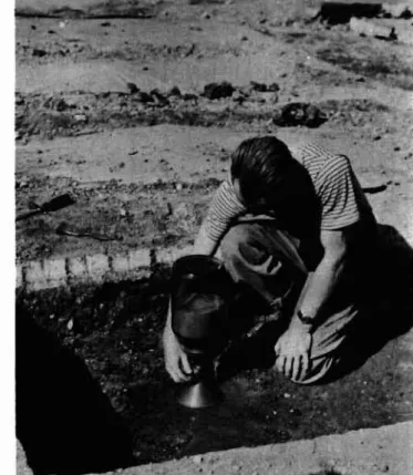
Corrosion and Erosion by Winnipeg Soils by J. Sill
The chemical activity of Winnipeg soils appears to be intermediate between the high alkali soils of southern Saskatchewan and the low alkali soils of Eastern Cenada. The water soluble salts vary from practically zero in the black soil region up to almost
4
per cent in some of the yellow and blue clays. One example of the variation of soluble solids in the soils is given on River Avenue where, over a distance of approximately one mile, the concentration changes from.04
per cent to3.1
per cent. The effect ofvarying concentrations of these salts on pipe buried in the soil has been a subject of ョオセ・イッオウ investigations dating as far back as 1914.
The first pipe laid in Winnipeg consisted of wooden staves held together by セ・エ。ャ strap or wire. In most cases, however, this metal soon perished and the pipe collapsed.
This was then followed by cast-iron pipe, a great deal of which is still used for water mains in Winnipeg, even though its
life expectancy varies between ten and sixty years, depending almost entirely upon the soluble salts in the soil. At times rnanuf ac t.ur-er-s have supplied sample s of centrlfugal cast-iron pipe, steel pipe and various steel alloys for experiment, but
all have been found unsatisfactory despite the fact that installations in other parts of North America have indicated a high resistance to corrosion.
The City of wゥイセャゥー・ァ Engineering Department, the
Bureau of Standards, the lnlinnipeg Electric Company and the late Dr. J. W. Shipley of the University of Manitoba all conducted
investigations, both individually and collectively, but all failed in their attempts to either prevent the corrosive action or to differentiate between the different types which have occurred. Two different types of corrosion were found, namely, graphitization and pitting. The type known as graphiti-zation is characterized by the iron being transformed into
soft oxides and hydrates and occupying the space formerly held by the iron. The pipe is thus preserved to such an extent that, even though it is completely corroded through, it may still act as a conduit until subjected to some undue strain or pressure. No superficial evidence of corrosion may appear, but the graphitic appearance of the pipe and the fact that it may very easily be pierced by a sharp instrument will reveal the extent of the corrosion. The type known as pitting is
characterized by the appearance of small pockets from which the iron had been comple t.el y removed Le aving a small depre ssion in the pipe. This depression gradually became deeper, eventually
イ・ウオャエゥイセ in a hole, with the metal surrounding this hole generally left intact.