HAL Id: hal-00297379
https://hal.archives-ouvertes.fr/hal-00297379
Submitted on 14 Feb 2006
HAL is a multi-disciplinary open access
archive for the deposit and dissemination of
sci-entific research documents, whether they are
pub-lished or not. The documents may come from
teaching and research institutions in France or
abroad, or from public or private research centers.
L’archive ouverte pluridisciplinaire HAL, est
destinée au dépôt et à la diffusion de documents
scientifiques de niveau recherche, publiés ou non,
émanant des établissements d’enseignement et de
recherche français ou étrangers, des laboratoires
publics ou privés.
Diagnosis and numerical simulations of a heavy rain
event in the Western Mediterranean Basin
D. Santos-Muñoz, M. L. Martín, M. Y. Luna, A. Morata
To cite this version:
D. Santos-Muñoz, M. L. Martín, M. Y. Luna, A. Morata. Diagnosis and numerical simulations of a
heavy rain event in the Western Mediterranean Basin. Advances in Geosciences, European Geosciences
Union, 2006, 7, pp.105-108. �hal-00297379�
Advances in Geosciences, 7, 105–108, 2006 SRef-ID: 1680-7359/adgeo/2006-7-105 European Geosciences Union
© 2006 Author(s). This work is licensed under a Creative Commons License.
Advances in
Geosciences
Diagnosis and numerical simulations of a heavy rain event in the
Western Mediterranean Basin
D. Santos-Mu ˜noz1, M. L. Mart´ın2, M. Y. Luna1, and A. Morata1
1Instituto Nacional de Meteorolog´ıa, Madrid, Spain
2Dpto. Matem´atica Aplicada, Escuela de Inform´atica, Campus de Segovia, Universidad de Valladolid, Spain
Received: 7 October 2005 – Revised: 3 January 2006 – Accepted: 23 January 2006 – Published: 14 February 2006
Abstract. The heavy rain event of November 2001 in the
western Mediterranean area was synoptically characterized by the presence of a long-lived Omega blocking geopoten-tial pattern. A set of mesoscale numerical simulations us-ing MM5 is performed to investigate the mechanisms re-sponsible for the convection development through several output diagnosis. A potential vorticity evolution showed how dry air masses were extruded from the stratospheric levels promoting strong cyclonic circulation at all levels. Moreover, a deep vertical column of high relative humid-ity over the Algerian coastline maintained the few and ge-ographically confined convective cells responsible for the heavy precipitation. Mesoscale environment parameters in-dicated enhanced conditional instability through a deep tro-posphere layer. Also, strong vertical wind shear values, higher than 50 ms−1over the troposphere, were derived,
in-dicating enough strength to promote necessary conditions to organize and keep mesoscale convective structures.
1 Introduction
The closed characteristic of the Mediterranean Sea and the high insolation received during long part of year lead to high sea surface temperatures during summer and autumn which ensure warm, moist air that can be raised over the orogra-phy. This situation favors instability and the release of vast amounts of latent heat. The result is the development of thunderstorms which may be a single supercell, a squall line or even secondary cyclones (Font, 2000). This paper is de-voted to analyze the temporal evolution of the synoptic and mesoscale features conducing to the heavy rain episode of 8 to 21 November 2001 in the Western Mediterranean area. Heavy precipitation mainly affected the northern of Africa and the Balearic Islands, with particularly heavy 24-h rain-fall totals on 10 November over Algeria and on 11 November
Correspondence to: M. Y. Luna
(yluna@inm.es)
over the Balearic Islands. MM5 numerical simulations were used to identify the key factors that explain the event.
2 Diagnostic methodology
The non-hydrostatic mesoscale model (MM5, version 3) of the Pennsylvania State University-National Center of Atmo-spheric Research is used (Anthes and Warner, 1978; Grell et al., 1994). It is formulated using the terrain following σ coordinate system and the details of the physical param-eterizations can be found in the references. The model has two-way interaction between successive nesting levels that allows realistic terrain characteristics. Figure 1a shows the fine grid domain centred in the eastern Iberia and its orog-raphy. This domain measures 1720×1510 km under a Lam-bert conformal map projection (10 km to horizontal spacing). Figure 1b shows the selected coarse domain that measures 4530×3030 km and is centered at the same location. The time steps are chosen as 30 and 90 s for the fine and coarse grids, respectively. The initial and boundary conditions for the coarse grid are taken from NCEP global reanalysis data (available at 00:00, 06:00, 12:00 and 18:00 UTC) with a res-olution of 2.5 degrees. Two simulations for each day have been performed from 00:00 and 12:00 UTC till 00:00 and 12:00 UTC (next day), respectively. The integrations start at 00:00 UTC on 8 November 2001 and finish at 00:00 UTC 22 November 2001.
3 Diagnosis of the case of November 2001
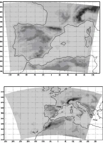
The rainfall maximum for the event was recorded in the Al-geria coastline and exceeded 300 mm on 10 and 11 Novem-ber with 140 mm on only six hours (Fig. 2). The synop-tic configuration reflects a blocking pattern named “Omega block” with a zonally oriented configuration of a high situ-ated over western British Island in between two lows. The main low was located at southern Genoa Gulf with an as-sociated front. At 300 hPa, a jet streak crossing from the
106 D. Santos-Mu˜noz et al.: Diagnosis and numerical simulations of a heavy rain event
Fig. 1. (a) The used centered fine grid domain and its orography; (b) The selected coarse domain.
north of Africa to western Mediterranean was noticeable, driving large-scale instability conditions. The upper level winds were intense and nearly perpendicular to Atlas moun-tain ridge encouraging the instability conditions. More de-tails of the synoptic description can be found in Genoves and Jansa (2002) and Tripoli et al. (2005).
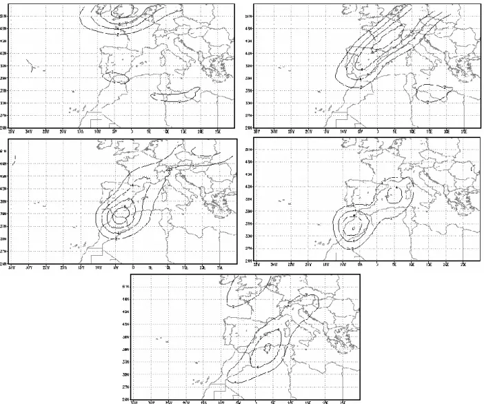
A Potential Vorticity (PV) evolution from 8 to 12 Novem-ber at 300 hPa, 12:00 UTC (Fig. 3) reflects a strong pool that progresses from the high latitudes to the western and cen-tral Mediterranean area, from the NW Iberia to the north-ern Africa. There are remarkably high values of PV units (higher than 8 PVU), which indicate lowering of the dynam-ical tropopause and intrusions of stratospheric air. In this situation, rapid pressure falls occurred at low levels in jux-taposition with the upper level jet streak. The associated positive (negative) PV advection is situated ahead (rear) of the PV anomaly, indicating that quasigeostrophic forcing for vertical upward (downward) motions will occur owing to the increase of such advection with height. Consistent with the jet-induced upward forcing features, the model diagnoses upward vertical velocity throughout the troposphere. On 9 November at 18:00 UTC (Fig. 4a), it can be noted a vigorous plume of upward motion extending from surface to 300 hPa over a narrow area of northern Africa. Another significant feature is the existence of a deep vertical column of high
rel-Fig. 2. 24-h precipitation in the western Mediterranean basin: (a) 10 November 2001; (b) 11 November 2001. Contours every 50 mm, starting in 50 mm.
ative humidity spanning over the Algerian coastline which keeps the few and geographically confined convective cells responsible for the heavy precipitation. On 11 November at 06:00 UTC (Fig. 4b), it is highlighted another centre of in-tense upward motion over the Balearic area with a high rel-ative humidity column throughout the troposphere over the same zone. Lower relative humidity values (not shown) are present over western Iberia according with the dry air ex-truded from the stratospheric levels associated with the PV anomalies. On the contrary, higher values of relative humid-ity can be observed over the Atlas Mountains and the Spanish Mediterranean littoral coinciding with an area of vertical up-ward motions.
Standard tools of convective storm analysis, such as the totals-totals index (TTI), the lifted index (LI) and the K in-dex (KI), have been obtained from the simulations and they showed an enhanced conditional instability through a deep troposphere layer. Throughout the episode, large values of vertical wind shear higher than 50 ms−1over the troposphere were derived, indicating enough strength to promote neces-sary conditions to organize and maintain long-lived supercell
D. Santos-Mu˜noz et al.: Diagnosis and numerical simulations of a heavy rain event 107
Fig. 3. Diagnosed Potential Vorticity at 300 hPa, 12:00 UTC: (a) 8 November; (b) 9 November; (c) 10 November; (d) 11 November and (e) 12 November 2001. Interval contour is 2 PVU (10−6m2s−1K kg−1)starting in 2 PVU.
convective structures. The values of the convective available potential energy (CAPE) were high, extending the affected zone from Algeria, on 9 November with values higher than 1000 J kg−1, to the Balearic area on 11 November with val-ues of up to 800 J kg−1, and reflecting intense vertical mo-tions of individual air parcels.
4 Conclusions
The explosive storm development over the western Mediter-ranean area was due to a number of factors all coming to-gether at the same place and time. The contribution from the large-scale conditions was crucial. A synoptic critical control was the blocking omega pattern that promoted the channel-ing effect. This synoptic scenario acted to induce mass ascent and release of conditional instability. Moreover, the lifting on the Atlas Mountain and the Balearic orography together
with the front associated with the main low contributed to ad-ditional mesoscale ascent and subsequently severe weather. The MM5 numerical analysis identified air masses marked by strong upper-level PV stretching to increase relative vor-ticity, which augments deepening of a cyclone. Ahead of the PV maximum, the increase of positive vorticity advec-tion with height favored vertical upward moadvec-tions, resulting on a mesoscale convective system.
Acknowledgements. This work has been partially supported by the research project CGL2004-01584/CLI. The authors wish to thank to the NOAA-CIRES Climate Diagnostics Center, Boulder, Colorado, USA for the NCEP Reanalysis data. We are also very much indebted to the referees for their helpful discussions concerning this work.
Edited by: V. Kotroni and K. Lagouvardos Reviewed by: anonymous referee
108 D. Santos-Mu˜noz et al.: Diagnosis and numerical simulations of a heavy rain event
Fig. 4. Vertical cross section showing relative humidity (contours every 20%, starting in 40, dashed line) and upward vertical velocity (contour interval is 0.4 ms−1, starting in 0.4, continuous line): (a) 9 November, 18:00 UTC; (b) 11 November, 06:00 UTC. The cross sections are realized along the lines indicated in the corresponding upper left corner map.
References
Anthes, R. A. and Warner, T. T.: Development of hydrodynamic models suitable for air pollution and other mesometeorological studies, Mon. Wea. Rev., 106, 1054–1078, 1978.
Font, I.: Climatolog´ıa de Espa˜na y Portugal, 2nd ed. Ed. Universi-dad de Salamanca, Spain, 2000.
Genov´es, A. and Jans´a, A.: Diabatic processes contribution to the November 2001 storm, Proc. 4th EGS Plinius Conference, Mal-lorca, Spain, 2002.
Grell, G. A., Dudhia, J., and Stauffer D. R.: Diagnosing coupled jet streak circulations for a northern plains snow band from the operational nested-grid model, Wea. Forecast., 7, 26–48, 1994. Tripoli, G. J., Medaglia, C. M., Dietrich, S., Mugnai, A.,
Pane-grossi, G., Pinori, S., and Smith, E. A.: The 9–10 November 2001 Algerian flood, Bull. Amer. Meteorol. Soc., 86, 1229–1235, 2005.