Centre for Hydrogeology
and Geothermics (CHYN)
University of Neuchâtel
www.unine.ch/chyn
Ph.D. thesis presented to the Faculty of Science of the University of Neuchâtel
to satisfy the requirements of the degree of Doctor of Philosophy in Science
by
Oliver S. Schilling
Thesis defense date: 01.02.2017
Public defense date: 07.04.2017
Ph.D. Thesis evaluation committee:
Prof. Dr. Philip Brunner, University of Neuchâtel (Director of thesis)
Prof. Dr. Daniel Hunkeler, University of Neuchâtel (Co-director)
Prof. Dr. Harrie-Jan Hendricks Franssen, Forschungszentrum Jülich, Germany
Dr. John Doherty, Watermark Numerical Computing, Australia
Advances in characterizing surface
water - groundwater interactions:
combining unconventional data with
Imprimatur pour thèse de doctorat www.unine.ch/sciences
Faculté des Sciences
Secrétariat-décanat de Faculté Rue Emile-Argand 11 2000 Neuchâtel – Suisse Tél : + 41 (0)32 718 21 00 E-mail : [email protected]
IMPRIMATUR POUR THESE DE DOCTORAT
La Faculté des sciences de l'Université de Neuchâtel autorise l'impression de la présente thèse soutenue par
Monsieur Oliver S. SCHILLING
Titre:
“Advances in characterizing surface water -
groundwater interactions:
combining unconventional data with
complex, fully-integrated models”
sur le rapport des membres du jury composé comme suit:
• Prof. Philip Brunner, directeur de thèse, Université de Neuchâtel, Suisse • Prof. Daniel Hunkeler, co-directeur de thèse, Université de Neuchâtel, Suisse • Prof. Harrie-Jan Hendricks Franssen, Forschungzentrum Jülich, Allemagne • Dr. John Doherty, Watermark Numerical Computing, Brisbane, Australie
I have yet to see any problem, however complicated, which when you looked at it in the right way did not become more complicated.
Summary
The characterization and simulation of the interactions between surface water and groundwater require observations of hydrological state variables and flow processes. While the latest generation of physically-based flow models allows the integrated simulation of all relevant hydrological processes, the current modelling practice is not adequate to provide reliable predictions. Numerous studies suggest that the main reason for this limited predictive capability is that the complex nature of surface water - groundwater systems cannot be sufficiently described and constrained by only considering the ‘classical’ hydrogeological observations of surface water discharge and hydraulic head. An extensive literature review on this topic is provided in Chapter 2. To overcome the problem of inadequate surface water - groundwater flow model calibration, alternative, unconventional observations should be considered, for example observations of solute concentrations or exchange fluxes. With the appropriate modelling and calibration tools, unconventional observations can not only be successfully included in flow model calibration, but by choosing the right tools it is also possible to quantify the information content of unconventional observations towards reducing the predictive uncertainty of flow models. This was the focus of this thesis and is illustrated in multiple studies: In Chapter 4, a new method that uses tree ring growth records to infer the historic transpiration rates of riparian desert trees of the Tarim River was developed. These new and unconventional observations were successfully used for the calibration of an integrated surface water - groundwater - vegetation flow model built with HydroGeoSphere. A post-calibration uncertainty analysis allowed quantifying the high worth of these unconventional observations in reducing the predictive uncertainty of the flow model. In the study presented in Chapter 5, the established tracer methods using Radon-222 and Helium-Tritium were for the first time complemented by a novel tracer method based on Argon-37, which allowed closing a previously existing gap in residence times characterization. A multi-tracer study carried out on an important drinking water wellfield in Switzerland provided an ideal framework to test the new method alongside other tracer methods. Following the successful characterization of residence times of groundwater in the drinking water wellfield, a quantification of mixing of different types of groundwater, i.e. of recently infiltrated river water and of old groundwater, was achieved through noble gas end-member analysis. The information on mixing of different types of groundwater was subsequently used to inform the parametrization of an integrated surface water - groundwater flow model of the drinking water wellfield. It could be shown that the use of mixing information contains information about exchange fluxes and can successfully inform a flow model parametrization beyond the capabilities of classical observations of groundwater heads and surface water discharge. One important aspect of surface water - groundwater interactions is the state of connection between the two water bodies. If unsaturated flow processes are expected in a given surface water - groundwater system, it is important that the numerical model which is used to simulate these systems is capable of simulating unsaturated flow. The study in Chapter 3 is dedicated to the development of a Monte-Carlo-based method which allows the rapid quantification of the potential for unsaturated flow processes underneath heterogeneous riverbeds overlying heterogeneous aquifers. This in turn allows a preliminary assessment of the conceptual model of a give surface water-groundwater system.
And finally, as the integrated simulation of surface water - groundwater interactions requires a lot of computational resources, especially when unsaturated flow processes dominate, a modelling framework using HydroGeoSphere, Ensemble Kalman Filter and cloud resources was developed in order to leverage typically limited computational resources. This framework is presented in Chapter 6.
Keywords: surface water-groundwater interactions, tracers, tree rings, Argon-37, noble gases, groundwater model calibration, ensemble Kalman filter, HydroGeoSphere, cloud computing
Résumé
Caractériser et simuler les interactions entre les eaux de surface et souterraines s’avère être un enjeu de plus en plus important afin de garantir une eau de qualité pour des puits de pompage situés à proximité d’une rivière. Grâce à la dernière génération de modèles numériques physiques intégrant les écoulements de surface et souterrains, il est maintenant possible de simuler tous les processus physiques gouvernant ces interactions. Cependant, les résultats de ces modèles sont souvent peu satisfaisants. Plusieurs études suggèrent que l’utilisation des charges hydrauliques et des débits de la rivière n’est pas suffisante pour décrire et contraindre ces processus complexes. Une revue bibliographique de ces différentes études est présentée dans le chapitre 2. Afin de parvenir à un meilleur calage de ces modèles, l’utilisation d’autres types d’observations que l’on peut qualifier de non-conventionnelles doit être envisagée. Ces observations non-conventionnelles peuvent être par exemple les flux caractérisant les interactions ou la concentration de solutés. Le but principal de cette thèse de doctorat est de montrer que l’utilisation de ces observations non conventionnelles permet non seulement d’améliorer significativement le calage de ces modèles, mais également de réduire grandement les incertitudes de leurs projections.
Le chapitre 4 présente le développement d’une nouvelle méthode utilisant l’accroissement de cernes des arbres afin de quantifier l’historique de transpiration des arbres riverains. Les observations non-conventionnelles obtenues grâce à cette méthode ont ensuite été utilisées pour caler un modèle HydroGeoSphere couplant les écoulements souterrains et de surface ainsi que la transpiration des végétaux. Une analyse d’incertitude a permis de quantifier la réduction de l’incertitude induite par l’utilisation de ces observations non-conventionnelles.
Le chapitre 5 présente l’utilisation de traceurs naturels afin de caler un modèle d’écoulements souterrains et de surface. Cette étude fut réalisée dans le cadre d’un essai de traçage réalisé dans un champ de captage situé en Suisse. Après avoir évalué le temps de résidence de l’eau en utilisant les concentrations en argon-37, une analyse du mélange entre les eaux récemment infiltrées et les eaux plus vieilles a été réalisée en analysant les températures d’infiltration des gaz rares. Ces deux informations qui permettent de décrire les interactions entre la rivière et l’aquifère furent utilisées en plus des observations conventionnelles pour caler et contraindre le modèle de ce champ de captage. Les résultats obtenus montrent clairement une amélioration des capacités prédictives du modèle ainsi qu’une diminution de ses incertitudes.
Le chapitre 3 décrit une nouvelle méthode utilisant la méthode de Monte-Carlos afin d’identifier des zones non saturées entre le lit d’une rivière et d’un aquifère tous deux aux propriétés hétérogènes. Finalement, le chapitre 6 présente une nouvelle approche de simulation utilisant HydroGeoSphere, le filtre de Kalman d'ensemble (EnKF) et du nuage informatique (cloud computing) afin d’augmenter les ressources de calcul qui généralement sont importantes dans le cadre de modélisations numériques complexes.
Preface
Water is our most important resource, and in surface water-groundwater systems water interacts with the soil, our second most important resource. We have an obligation to protect these ecosystems and our two most important resources, especially to guarantee a safe and sustainable drinking water supply. After a little more than four years of working on my Ph.D. at the CHYN, with a lot of effort, countless field-trips, numerous inspiring discussions, hundreds of papers read, multiple conference visits and interesting presentations, many new colleagues met and friends won, this thesis in a way represents the culmination of all this. To me the main goal in the beginning of this Ph.D. was to achieve a better understanding of the incredible complexity of hydrogeological modelling, because I came to realize that surface water-groundwater modelling requires expertise not only in hydrology and hydrogeology, but also in algebra, numerics, inverse mathematics, statistics, biology, geology, climate processes, fluid dynamics, isotope chemistry and ecology. Only if one has a sufficient understanding of all these different disciplines one can produce reasonable flow models and predictions with them. I realized that there is still much that I needed to learn, so that the simulations I make can better support the decision-making process. Now that I finished my Ph.D. at the CHYN, I can say that I have learned a tremendous amount about almost all the topics above. But I also came to accept that being a real expert in all of the individual fields simultaneously is pretty much impossible. However, I’m convinced that surface water-groundwater systems research requires interdisciplinary knowledge, and this in turn requires the collaboration of experts from many different fields and groups. Luckily I had the chance to work with some of the best in the field, and this really helped taking the research presented in this thesis to a whole other level. With this very interdisciplinary Ph.D. thesis I hope that I contribute to supporting a more scientifically sound and more sustainable decision-making process when it comes to protecting our two most important resources water and soil.
Acknowledgements
This thesis would not have been possible without the support and contributions of many excellent colleagues and friends. I want to thank all the people who worked with me, and made this thesis possible. Working with you was great, and I've learned a tremendous amount from everyone’s unique expertise. First and foremost, I would like to thank Roberto, Laurent, Anne-Marie, Christoph and Roland. Your support and expertise in the field and with measurement techniques was indispensable and crucial to the success of my Ph.D. Philipp, Alice, Claire, Léa, Celia, Julien, Fabien and James it was a pleasure working with you at the CHYN. Thank you for your support both in the field and elsewhere. Dear officemates Christian, Guillaume, Dan Partington and Daniel Kaeser, it was great sharing E119 with you. The discussions about work but also about (PhD) life were inspiring. Daniel Kaeser, thank you very much for all the great work you did in the Emmental prior to my arrival, and your introduction and support in the beginning of my Ph.D. Dan Partington, what can I say? Thank you for the inspiration, the help, and above all your friendship. I’m looking forward to future collaborations and happenings together. Wolfgang, Tang Qi and Andrei, thank you for our great collaboration on our HGS-EnKF-cloud project. What an effort! It’s incredible that we managed to pull this off between Jülich and Neuchâtel. Simon, Matthias, Lina, Yama, Elahe, Yvo, Wendelin and Andrea, thank you for your help in the lab and with the noble gas and miniRuedi measurements. Dylan and Sarah, you inspired me and became good friends in Australia. With your great scientific minds and your academic progression, you continue to inspire me. Jürg and the whole Weber-Bann group, thank you for providing me asylum at ETH Hönggerberg on Fridays and doing sports with me. Eric and Tom, it was great to regularly present the latest progress of my Ph.D. at the SFWMD headquarters in West Palm, and to do the occasional field work with you guys at the LILA site. Thank you for supporting me. Eric, you are an inspiration to me in many ways and I hope that we can keep up our almost annual meetings. Lynn and Lloyd, doing two internships with you and visiting you in Australia essentially shaped my ideas about where I want to go and what I need to know to get there. The time spent and discussions held with you during our time together at CSIRO and NTEC motivated me to do this Ph.D. in the first place, and provided me with an outside-of-the-box, let’s-first-take-a-step-back-and-think way of thinking that proved to be essential during my studies. I would like to highlight that nothing would have been possible without the endless support of my supervisors. Philip, Daniel, Harrie-Jan and RoKi, your inputs and support was extremely appreciated and I learned a tremendous amount from you. Thank you for the many inputs and ideas for the Emmental project, Daniel. Roland, it was great to have you and Christoph aboard the Emmental project and do the multi-tracer study. I think this turned out to be an exceptionally good project. Dear RoKi, you have supported me throughout my BSc, MSc and PhD, and we are even going to collaborate during my postdoc. I am sure that you understand how much I appreciate this. Harrie-Jan, thank you for your inputs and the many discussions with Wolfgang, Tang Qi and Philip. The meetings always provided new insights and ideas, and helped to improve my work. And last but not least, Philip. You are my science mentor, your inspiration makes me want to keep on doing research, and you are the best supervisor I could imagine. You were always on top of things, and your inputs always helped me to progress my work. I think we achieved more than we hoped for in the beginning. I cannot thank you enough. I hope that we can continue our fruitful collaborations, and develop and investigate many more ideas and topics together. Finally, of course, I especially want to thank my girlfriend Tanja, my family Ursula, Sigurd and Iris, and my friends. Thanks to you I was able to focus on work when I wanted to, but also forget about work when I needed to. You’re the best family and friends one can have.
Table of contents
Summary ... VII Résumé ... IX Preface ... XI Acknowledgements ... XIII 1. Introduction ... 21.1. Context and motivation ... 2
1.1.1. Surface water-groundwater systems ... 2
1.1.2. Current state of research ... 3
1.2. Research objectives & structure of this thesis ... 5
1.2.1. Field sites ... 5
1.2.2. Review of unconventional data in SW-GW model calibration ... 5
1.2.3. Estimating the spatial extent of unsaturated zones in heterogeneous river-aquifer systems ... 6
1.2.4. Using tree rings as a proxy for transpiration in SW-GW model calibration ... 6
1.2.5. Advancing physically-based flow simulations of alluvial systems through atmospheric noble gases and the novel 37Ar tracer method ... 7
1.2.6. EnKF-HGS: A cloud-based data assimilation framework using the Ensemble Kalman Filter and HydroGeoSphere ... 7
1.3. References ... 7
2. Review on the worth of unconventional observations in groundwater model calibration ... 12
2.1. Introduction ... 12
2.2. Review of unconventional observation types ... 16
2.2.1. Review strategy ... 16 2.2.2. Temperature ... 18 2.2.3. Exchange fluxes ... 19 2.2.4. Solute concentrations ... 21 2.2.5. Evapotranspiration ... 27 2.2.6. Soil moisture ... 28
2.3. Summary and conclusions ... 29
2.4. References ... 34
3. Estimating the spatial extent of unsaturated zones in heterogeneous river-aquifer systems ... 44
3.1. Introduction ... 45
3.2. Materials & methods ... 48
3.2.1. Overview of proposed approaches ... 48
3.2.2. The stochastic 1-D approach ... 48
3.2.3. Three experiments to assess the reliability of the stochastic 1-D approach ... 49
3.3. Terminology and general considerations ... 49
3.4. Numerical simulator ... 51
3.5. Experimental setups ... 52
3.5.1. Experiment 1: Comparing the unsaturated area estimated with the stochastic 1-D approach to fully-heterogeneous 3-D reference simulations ... 53
3.5.2. Experiment 2: Influence of horizontal redistribution on the development of unsaturated zones ... 55
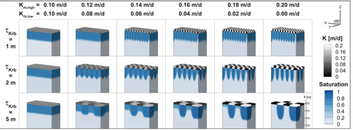
3.5.3. Experiment 3: Influence of heterogeneity on the development of unsaturated zones .... 56
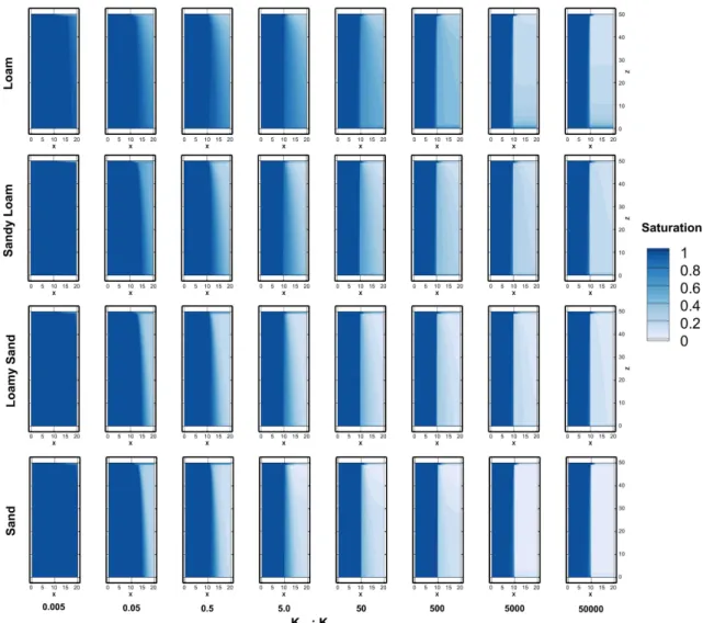
3.6. Results ... 58
3.6.1. Results of Experiment 1: Comparing the unsaturated area estimated with the stochastic
3.6.2. The influence of soil type and background saturation on the development of
unsaturated zones ... 59
3.6.3. The influence of geologic structures on the development of unsaturated zones ... 62
3.7. Discussion ... 64
3.8. Conclusions ... 65
3.9. Acknowledgements ... 66
3.10. References ... 66
4. Using tree rings as a proxy for transpiration in SW-GW model calibration ... 72
4.1. Introduction ... 73
4.2. Materials & methods ... 75
4.2.1. Study site ... 75
4.2.2. Estimating transpiration from tree ring growth ... 77
4.2.3. Modelling ... 79
4.3. Results ... 87
4.3.1. Riparian water use efficiency ... 87
4.3.2. Predictive uncertainty and data worth ... 88
4.3.3. Flow of information ... 89
4.4. Discussion & conclusions ... 91
4.5. Appendix ... 92
4.6. Acknowlegements ... 94
4.7. References ... 94
5. Advancing physically-based flow simulations of alluvial systems through atmospheric noble gases and the novel 37Ar tracer method ... 100
5.1. Introduction ... 101
5.2. Material & methods ... 104
5.2.1. Theory of natural environmental tracer methods ... 104
5.2.2. Study site ... 107
5.2.3. Pumping experiment & sampling strategy ... 109
5.2.4. Surface water-groundwater modelling ... 110
5.3. Results ... 114
5.3.1. Classical observations: GW levels, temperature and SW discharge ... 114
5.3.2. Results of the SW-GW simulations ... 116
5.4. Environmental tracer results ... 119
5.4.3. Identifying the appropriate model structure: comparing measured and simulated pumped water mix and travel times ... 126
5.5. Discussion ... 126
5.6. Conclusions ... 128
5.7. Acknowledgements ... 128
5.8. References ... 129
6. Integrating hydrological modelling, data assimilation and cloud computing for real-time management of water resources ... 136
6.1. Introduction ... 137
6.2. Conceptual framework ... 139
6.2.1. Data acquisition and management ... 140
6.2.2. HydroGeoSphere ... 141
6.2.3. Data assimilation with HydroGeoSphere ... 141
6.2.4. Cloud computing with CLAUDE ... 144
6.3. Validation example ... 146
6.3.1. Hydrological model and data assimilation setup ... 147
6.3.2. Simulation results ... 149
6.3.3. Performance analysis of the EnKF-HGS modelling and data assimilation platform in the cloud environment ... 152
6.4. Discussion ... 158 6.5. Conclusions ... 160 6.6. Acknowlegements ... 161 6.7. References ... 161 7. Conclusions ... 168
1.
Introduction
1.1. Context and motivation
1.1.1. Surface water-groundwater systems
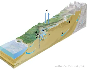
Surface water-groundwater (SW-GW) systems are the focus of a lot of ongoing research (Boano et al., 2014; Boulton et al., 2010; Brunner et al., 2009a; Fleckenstein et al., 2010; Harvey and Gooseff, 2015). Of particular interest are alluvial valleys, where the interactions between groundwater (GW), surface water (SW), and surrounding ecosystems, are highly dynamic on various spatial and temporal scales (Fig. 1.1). Such alluvial valleys are immensely important ecosystems and act as hotspots of biological and chemical processes (Boano et al., 2014; Boulton et al., 2010). Moreover, the typically high permeability of alluvial aquifers provides ideal conditions for drinking water production. In Switzerland, for example, 36% of the total drinking water supply is GW pumped in the vicinity of rivers (Diem, 2013; Sinreich et al., 2012; Spreafico and Weingartner, 2005); the study of alluvial systems is therefore of particular importance to Switzerland.
Figure 1.1: Conceptual illustration of the flow paths through typical alluvial systems, modified after Winter et al. (1998). The different flow paths include: (1) shallow groundwater flow, (2) deep groundwater flow, (3) hyporheic flow, (4) precipitation and evapotranspiration, (5) surface water flow, and (6) artificial flow paths, such as groundwater pumping.
Alluvial water resources are valuable not only due to the typically high supply, but also due to the high quality (Diem, 2013); their management is therefore necessary to simultaneously guarantee the quality and sustainability of drinking water supplies, as well as, the protection riparian ecosystems from over-exploitation (Delottier et al., 2016).
Many of the river corridors in the world have undergone substantial changes due to anthropogenic influences such as channelization, agriculture, urban development, flood protection, and transport infrastructure. Besides the negative effects of ecosystem degradation due to altered channel morphology, sediment transport, and flow patterns, these anthropogenic developments have also increased the potential for contamination of drinking water resources (Fig. 1.2). With a changing climate and a growing human population, the pressure on these
Flow paths in alluvial systems modified after Winter et al. (1998) 1 2 3 4 6 5
resources is expected to further increase in the near future (Aeschbach-Hertig and Gleeson, 2012; Hunkeler et al., 2014).
Figure 1.2: Conceptual illustration of potential origins of the water that is pumped at alluvial drinking water stations in developed areas, modified after Winter et al. (1998). While the majority of the pumped water most likely originates from recharged river water (blue), both urban runoff (green) and agricultural runoff (brown) could eventually end up in the pumped water mix, and in a worst-case scenario, contaminate the drinking water resources.
To counteract these developments and increase the overall quality of Switzerland’s alluvial ecosystems, improve flood protection measures, and protect the alluvial drinking water resources, the Swiss government has implemented a new legislation, which requires 4’000 km of river restoration and channel-widening until 2084 (Göggel, 2012; Kurth and Schirmer, 2013). This distance is equivalent to the total distance of the Rhine (1’232 km) and the Danube (2’857 km) rivers combined.
Despite this major pending financial investment in river restoration, our understanding and prediction tools for the complex and dynamic alluvial systems have been inadequate to inform how alluvial river systems should ideally be restored and managed. How optimal conditions for sustainable drinking water, ecology health and flood protection can be simultaneously provided is thus still an open question, and is mirrored in the fact that no single, unified quality assessment or post-audit system of river restorations exists in Switzerland; past restorations in Switzerland have been post-audited according to strongly differing, individual measures (Kurth and Schirmer, 2013).
1.1.2. Current state of research
One of the reasons why our understanding of SW-GW systems was not adequate for the definition of a unified quality assessment system for river restorations is the fact that for a long time, SW and GW bodies were considered and studied as separate entities. We now understand that these systems are intimately linked and need to be studied in an integrated way (Winter et al., 1998). Many recent efforts to better characterize and predict connected SW-GW systems have focused on more integrative technologies, and many excellent tools are now available. These necessary tools to further improve our understanding and our predictions of SW-GW
modified after Winter et al. (1998)
Possible origins of water that is pumped
at drinking water stations
systems can be grouped into two main components: (1) integrated measurement techniques that allow the investigation of coupled SW-GW systems, and (2) integrated numerical modelling for SW-GW systems.
Recent advances in measurement techniques now allow observing and quantifying the interactions between SW, GW, and flora and fauna, as well as, drinking water stations, and include:
• a greater ability to measure parameters of SW-GW systems at a larger spatial and temporal extent for example through distributed temperature sensing (e.g., Kurth (2014)), drone-supported hyper spectral temperature sensing (e.g., (Dugdale, 2016)), or photogrammetry to measure the topography of immersed riverbeds (e.g., Feurer et al. (2008)).
• reconstruction of historic discharge regimes through the study of tree rings (dendrochronology, e.g., Gangopadhyay et al. (2009) or Meko et al. (2007)) • new approaches to investigate the subsurface structure of SW-GW systems (e.g.,
improved geohydraulic characterization of riverbeds through freeze-coring (Strasser et al., 2015)).
• improved detection of extremely rare isotopes, for example through ultra-precise purification techniques (e.g., for 37Ar and 39Ar (Riedmann and Purtschert, 2016)) or through atom trapping (e.g., Ritterbusch et al. (2016)). These developments now allow measuring extremely rare isotopes such as 37Ar, which can be used as a tracer
for residence times and mixing in the subsurface on intermediate timescales. Recent advances in modelling techniques now allow the simulation of the relevant riparian processes and enable predictions of the future behavior of riparian systems, and encompass:
• the fully-integrated, physically-based simulation of surface water, groundwater and vegetation processes in one simulator (e.g., HydroGeoSphere (Therrien et al., 2010), ParFlow (Kollet and Maxwell, 2006)).
• tracking the movement of water through the modelled domain without much extra computational costs (e.g., the Hydraulic Mixing Cell method (Partington et al., 2011)). This enables us to quantify mixing of water from different sources at any point within the model.
• highly parametrized regularized inversion, which allows the simultaneous and systematic calibration of hundreds of parameters according to mathematical procedures that optimally distribute the information content of observations to calibrated parameters (e.g., using PEST (Doherty et al., 2010)).
Substantial potential lies in combining the two different components, novel measurements of SW-GW systems and fully-integrated flow modelling, are combined (Simmons et al., 2012). However, while the recent scientific and technological advances have finally generated the necessary tools to overcome previous limitations in characterizing alluvial SW-GW interactions, Simmons et al. (2012) noted that there is a substantial gap between science and general practice: Many of the advance measurement techniques and modelling codes are rarely used outside of the scientific community.
The fact that this gap exists, and that the potential of unconventional observations in the context of flow modelling remains largely untapped, forms the major motivation for this Ph.D. thesis: The overarching aim is to provide better tools for the sustainable management of SW-GW
systems. The following section provides an overview of the research objectives and the different chapters of this Ph.D. thesis.
1.2. Research objectives & structure of this thesis
This Ph.D. thesis is an article-based thesis. The different articles form the different chapters of this thesis, and are self-containing, which means that in every chapter, an introduction to the topic and to the applied methods is given. A brief overview of the main field sites and research articles is provided below.
1.2.1. Field sites
1.2.1.1. Upper Emmental
One of the sites that will soon undergo restoration measures is the River Emme in the Upper Emmental. The Upper Emmental also hosts one of the most important drinking water stations for the Swiss capital Bern: on the Ramsei plain in Aeschau, GW is abstracted in the vicinity of the Emme River to provide roughly 40% of the total drinking water supply to the capital and its surroundings. Due to this interesting setting, the site recently started to be systematically investigated by the Centre of Hydrogeology and Geothermics (CHYN) of the University of Neuchâtel within the Swiss National Science Foundation National Research Program (NRP) 61 “Sustainable water management”. Throughout my Ph.D. studies I spent a considerable amount on this field site, and continued and managed the ongoing monitoring and instrumentation.
1.2.1.2. Tarim Basin
The other important field site in this Ph.D. thesis is also characterized by restoration efforts, however, in a different environmental setting and context: The lower reaches of the Tarim River. The Tarim River is located on the border of the Taklamakan Desert, an extremely arid region in Xinjiang, China. The unique riparian forests of the lower reaches of the Tarim River have suffered severe degradation due to an absence of SW flow since the 1970’s, when increased agricultural water use upstream began. Around the year 2000, the Chinese government initiated controlled freshwater releases in order to save the strongly endangered riparian forests. As part of my Ph.D., I studied the interactions between the riparian vegetation, the GW and the SW, and investigated the efficiency of these freshwater releases in restoring the riparian forests.
1.2.2. Review of unconventional data in SW-GW model calibration
Addressing the concern raised by Simmons et al. (2012) that in general practice not all available modelling tools and observations are used to assess SW-GW systems, one of the question that remained to be answered was whether, and to what extent, novel observations may improve the characterization of SW-GW systems. While the more different data are available on a system, the better the system can be characterized, how these data should be used to improve our predictions of the future behavior of SW-GW systems has not been systematically assessed. In numerical flow models used for the prediction of SW-GW systems, mainly the classical observations of hydraulic heads and SW discharge are used to calibrate the flow model. How novel, unconventional observations should be included into the flow model calibration process, on the other hand, and how much information these data contain in reducing the predictive uncertainty of the model, is largely unknown. An extensive and urgently needed review of the existing literature on this topic constitutes chapter 2. How classical and unconventional data
were included in the calibration of numerical flow models, and to what degree these data allowed informing model parameters and reducing predictive uncertainty, is summarized in this chapter.
1.2.3. Estimating the spatial extent of unsaturated zones in heterogeneous
river-aquifer systems
An important step in numerical flow model generation lies in the preliminary assessment of the conceptual model and the appropriate model structure. In terms of the conceptual model, it is important to understand and decide, which processes need to be included in the numerical model, e.g., only saturated or also unsaturated flow processes, fully-coupled and physically-based or strongly simplified SW-GW interactions. In terms of the appropriate model structure, it is important to choose the right amount of complexity that is included in the numerical model: Is it, for example, important to represent fully-heterogeneous and spatially-distributed subsurface structures, or can they be simplified to homogeneous structures? Or is it necessary to include unsaturated flow processes, or can the system be adequately represented with saturated flow processes. Multiple studies have investigated the state of connection between rivers and aquifers (e.g., Brunner et al. (2009a) and (2009b), Fleckenstein et al. (2006), Lamontagne et al. (2014), Wang et al. (2016)), and whether simplification of heterogeneous to homogeneous subsurface structures in the numerical model lead to a bias in predictions of the future connection states of the river-aquifer system (Irvine et al., 2012). None of these studies, however, systematically investigated how both heterogeneity of the riverbed and heterogeneity of the aquifer influence the development of unsaturated areas underneath the riverbed; even though an understanding of the potential spatial extent of unsaturated zones is crucial in choosing the appropriate conceptual model and an appropriate complexity for numerical flow simulations. To bridge this gap, we developed a simple stochastic 1-D approach to predict the upper bound of the spatial extent of unsaturated zones for a given heterogeneous riverbed-heterogeneous aquifer system. We furthermore investigated how horizontal capillary forces in the subsurface influence the development of unsaturated zones, and how heterogeneous structures control the distribution of unsaturated areas. This study is in submission as an original research article to Water Resources Research and constitutes chapter 3.
1.2.4. Using tree rings as a proxy for transpiration in SW-GW model calibration
How unconventional data can be successfully combined with fully-integrated numerical flow modelling using state-of-the-art inverse methods is presented in chapter 4: a novel approach to use tree ring growth records as a proxy for the estimation of historic transpiration rates is used to calibrate a physically-based numerical model. In this study, the worth of the tree-ring-based transpiration estimates in improving predictions made with a numerical flow model was systematically assessed using PEST, a sophisticated inverse tool with integrated uncertainty assessment. The study focused on the interactions between a river, GW and desert vegetation along the Tarim River. The Tarim River is the sole source of water for a vast area in the extremely arid Taklimakan Desert in Northwest China. Through transpiration of water, the trees along the Tarim River form a major component of the water balance of this SW-GW system. Since the 1970’s, due to massive divergence of water to a water reservoir in the upstream, the trees in the downstream, which provide the sole protection against the progressing desertification in the area, did not receive water anymore. Through artificial ecological freshwater releases in the Tarim River, starting after the year 2000, the Chinese authorities tried to save these trees by providing desperately needed groundwater recharge. The study summarizes the impact of the freshwater releases on the Populous euphratica trees along a stretch of the Tarim River, and quantifies the amount of transpired water. The tree ring growth
records, an unconventional data source, served as proxy for plant transpiration. These transpiration estimates were subsequently included in the multi-variable objective function for the calibration of a SW-GW model. This study is an extension of my Master of Science thesis from the Institute of Environmental Engineering (IfU) at the Swiss Federal Institute of Technology in Zürich (ETHZ), Switzerland, and was published as an original research article in the Journal of Hydrology in 2014.
1.2.5. Advancing physically-based flow simulations of alluvial systems through
atmospheric noble gases and the novel
37Ar tracer method
The overarching goal of the studies carried out in the Upper Emmental was to develop an ideal multi-tracer and modelling framework to quantify the interactions between river, groundwater and drinking water abstraction, and to identify the residence times and sources of the pumped GW. For this purpose, (i) a physically-based and fully-integrated numerical flow model of the drinking water wellfield was constructed, (ii) a multi-tracer study using state-of-the-art natural environmental tracers was carried out, and (iii) simulations and measurements were subsequently compared, and an appropriate predictive model for the field site identified. Moreover, in this multi-tracer study, a novel natural tracer method for SW-GW interactions based on 37Ar was employed and compared to established tracer methods. The study was
carried out in collaboration with the Climate and Environmental Physics & Oeschger Centre for Climate Research of the University of Bern, and with the Water Resources and Drinking Water Department of eawag. The study is presented in chapter 5 and in submission as an original research article to Water Resources Research.
1.2.6. EnKF-HGS: A cloud-based data assimilation framework using the
Ensemble Kalman Filter and HydroGeoSphere
In a collaborative effort between the IBG-6 of the Forschungszentrum Jülich and the CHYN at the Université de Neuchâtel, we developed a coupling of the physically-based flow model HydroGeoSphere (HGS) to the Ensemble Kalman Filter (EnKF) data assimilation framework, which we called EnKF-HGS. This combination allows continuously updating the system variables of a numerical flow model whenever new observations become available, and simultaneously calibrating flow parameters. This so-called data assimilation framework was then “cloudified” by the IIUN at the Université de Neuchâtel, in order to directly integrate the entire EnKF-HGS data assimilation framework on commercial compute clouds. With the integration of physically-based flow modelling with HGS, EnKF-based data assimilation and cloud-based computing possibilities, we combined the extremely powerful state-of-the-art technologies, which harbor an immense potential as simulation and prediction tools for the real-time management of drinking water wellfields. A similar albeit less powerful framework is already used at the biggest drinking water wellfield in Zurich, Switzerland (Hendricks Franssen and Kinzelbach, 2008). The EnKF-HGS-cloud framework is presented in chapter 6, and the original research article is under review at Environmental Modelling and Software.
1.3. References
Aeschbach-Hertig, W., Gleeson, T., 2012. Regional strategies for the accelerating global problem of groundwater depletion. Nat. Geosci., 5: 853-861.
Boano, F. et al., 2014. Hyporheic flow and transport processes: Mechanisms, models, and biogeochemical implications. Rev. Geophys., 52: 603-679.
Boulton, A.J., Datry, T., Kasahara, T., Mutz, M., Stanford, J.A., 2010. Ecology and management of the hyporheic zone: stream– groundwater interactions of running waters and their floodplains. J. N. Am. Benthol. Soc., 29(1): 26-40.
Brunner, P., Cook, P.G., Simmons, C.T., 2009a. Hydrogeologic controls on disconnection between surface water and groundwater. Water Resour. Res., 45.
Brunner, P., Simmons, C.T., Cook, P.G., 2009b. Spatial and temporal aspects of the transition from connection to disconnection between rivers, lakes and groundwater. J. Hydrol., 376(1-2): 159-169.
Delottier, H., Pryet, A., Dupuy, A., 2016. Why Should Practitioners be Concerned about Predictive Uncertainty of Groundwater Management Models? Water Resour. Manage.
Diem, S., 2013. Riverbank filtration within the context of river restoration and climate change, University of Neuchâtel, Neuchâtel, 144 pp.
Doherty, J.E., Hunt, R.J., Tonkin, M.J., 2010. Approaches to Highly Parameterized Inversion: A Guide to Using PEST for Model-Parameter and Predictive-Uncertainty Analysis, U.S. Geological Survey.
Dugdale, S.J., 2016. A practitioner’s guide to thermal infrared remote sensing of rivers and streams: recent advances, precautions and considerations. WIREs Water, 3: 251-268.
Feurer, D., Bailly, J.-S., Puech, C., Le Coarer, Y., Viau, A.A., 2008. Very high-resolution mapping of river-immersed topography by remote sensing. Prog. Phys. Geogr., 32(4): 403-419.
Fleckenstein, J.H., Krause, S., Hannah, D.M., Boano, F., 2010. Groundwater-surface water interactions: New methods and models to improve understanding of processes and dynamics. Adv. Water Resour., 33: 1291-1295.
Fleckenstein, J.H., Niswonger, R.G., Fogg, G.E., 2006. River-aquifer interactions, geologic heterogeneity, and low-flow management. Ground Water, 44(6): 837-52.
Gangopadhyay, S., Harding, B.L., Rajagopalan, B., Lukas, J.J., Fulp, T.J., 2009. A nonparametric approach for paleohydrologic reconstruction of annual streamflow ensembles. Water Resour. Res., 45.
Göggel, W., 2012. Revitalisierung Fliessgewässer. Strategische Planung. Ein Modul der Vollzugshilfe Renaturierung der Gewässer., Bundesamt für Umwelt, Bern, Switzerland. Harvey, J.W., Gooseff, M., 2015. River corridor science: Hydrologic exchange and ecological consequences from bedforms to basins. Water Resour. Res., 51.
Hendricks Franssen, H.J., Kinzelbach, W., 2008. Real-time groundwater flow modeling with the Ensemble Kalman Filter: Joint estimation of states and parameters and the filter inbreeding problem. Water Resour. Res., 44.
Hunkeler, D., Moeck, C., Kaeser, D., Brunner, P., 2014. Klimaeinflüsse auf Grundwassermengen. Aqua & Gas, 11: 42-49.
Irvine, D.J., Brunner, P., Hendricks Franssen, H.-J., Simmons, C.T., 2012. Heterogeneous or homogeneous? Implications of simplifying heterogeneous streambeds in models of losing streams. J. Hydrol., 424-425: 16-23.
Kollet, S., Maxwell, R., 2006. Integrated surface-groundwater flow modeling: a free-surface overland flow boundary condition in a parallel groundwater flow model. Adv. Water Resour., 29(7): 954-998.
Kurth, A.-M., 2014. Investigation of Groundwater-Surface Water Interactions with Distributed Temperature Sensing (DTS), Université de Neuchâtel, Neuchâtel, Switzerland.
Kurth, A.-M., Schirmer, M., 2013. Thirty years of river restoration in Switzerland: implemented measures and lessons learned. Environ. Earth. Sci., 72: 2065-2079.
Lamontagne, S. et al., 2014. Field assessment of surface water-groundwater connectivity in a semi-arid river basin (Murray-Darling, Australia). Hydrol. Process., 28: 1561-1572.
Meko, D.M. et al., 2007. Medieval drought in the upper Colorado River Basin. Water Resour. Res., 34.
Partington, D. et al., 2011. A hydraulic mixing-cell method to quantify the groundwater component of streamflow within spatially distributed fully integrated surface wateregroundwater flow models. Environ. Model. Softw., 26: 886-898.
Riedmann, R.A., Purtschert, R., 2016. Separation of argon from environmental samples for Ar-37 and Ar-39 analyses. Sep. Purif. Technol., 170: 217-223.
Ritterbusch, F. et al., 2016. Groundwater dating with Atom Trap Trace Analysis of 39Ar. Geophys. Res. Lett., 41: 6758-6764.
Simmons, C.T., Hunt, R.J., Cook, P.G., 2012. Using Every Tool in the Toolbox Ground Water, 50(3): 323.
Sinreich, M. et al., 2012. Grundwasserressourcen der Schweiz - Abschätzung von Kennwerten, BAFU, Bern.
Spreafico, M., Weingartner, R., 2005. Hydrologie der Schweiz, Ausgewählte Aspekte und Resultate. Berichte des BWG, Serie Wasser. Bundesamt für Wasser und Geologie (BWG), Switzerland, Bern, Switzerland.
Strasser, D. et al., 2015. Improved geohydraulic characterization of river bed sediments based on freeze-core sampling -development and evaluation of a new measurement approach. J. Hydrol., 527: 133-141.
Therrien, R., McLaren, R.G., Sudicky, E.A., Panday, S., 2010. HydroGeoSphere: A Three-dimensional Numerical Model Describing Fully-integrated Subsurface and Surface Flow and Solute Transport. Hydrogeosphere Manual.
Wang, W. et al., 2016. A quantitative analysis of hydraulic interaction processes in stream-aquifer systems. Sci. Rep., 6(19876).
Winter, T.C., Harvey, J.W., Franke, O.L., Alley, W.M., 1998. Ground water and surface water: a single ressource, USGS, Denver, USA.
2.
Review on the worth of unconventional
observations in groundwater model calibration
2.1. Introduction
Integrated and physically-based groundwater flow models (IFMs) are a common tool used for the characterization and management of coupled groundwater (GW) – surface water (SW) resources (Anderson et al., 2015). Simulations with IFMs typically require a significant number of parameters to be defined, but in reality these parameters are rarely known. Due to the limited ability of knowing the true parameter values, especially of strongly heterogeneous subsurface properties such as the hydraulic conductivity (K) or the porosity (f), IFMs always need to be calibrated against observations of system states. In general practice, only a limited number of different, ‘classical’ observations of system states are used to constrain the parameters of IFMs: measurements of hydraulic head (H) and measurements of SW discharge (QSW). Hydraulic
heads are the observation type that is used in the calibration of virtually every regional groundwater flow model – and for a good reason: the information contained in observations of H is of pivotal importance for the reproduction of groundwater heads. Unfortunately, while observations of H contain substantial information about the diffusion or propagation of pressure and the related changes in groundwater heads, they do not contain sufficient information about fluxes, that is, the volume of flow (see for example Anderson et al. (2015), Delottier et al. (2016), Haitjema (2006), Hill and Tiedeman (2007), Townley (2012)). While observations of QSW, on the other hand, do allow to constrain the water balance, unless
measured in a dense measurement network they only provide an integrated information about the catchment response; this information does not suffice in informing about the spatial distribution of the hydrologically relevant parameters, and is thus limited in its capability to inform about the volume of flow in the subsurface. Consequently, the large number of spatially distributed and often statistically correlated parameters required for IFMs cannot sufficiently be constrained by these two classical observation types alone. The high dimensionality and complexity IFMs can thus pose a substantial challenge for robust model calibration and for providing predictions with a reasonably small predictive uncertainty (e.g., Everitt and Hothorn (2011), Doherty (2015), Hill and Tiedeman (2007)). The problem is further amplified when predictions other than those related to purely advective flow are required, for example mass transport or heat transport: the simulation of these additional processes introduces even more unknown parameters to the model, on which neither observations of H or QSW contain much
information. To provide an overview on the different processes and the minimally required parameters and boundary conditions in IFMs, a summary is given in Table 2.1.
Tab. 2.1 highlights that it is unlikely that one single observation type provides enough information to sufficiently constrain all unknown parameters as well as boundary and initial conditions at once. The high number of degrees of freedom combined with the limited information content of one single observation type inevitably results in correlation, where the increase in one parameter can be eliminated by the decrease in another parameter (in terms of the reproduction of fluxes, for example, an increase in the hydraulic conductivity K can be compensated by an increase in porosity f). In the case of incomplete knowledge of the necessary boundary conditions, boundary conditions might even require calibration as well (e.g., Erdal and Cirpka (2016), Hendricks Franssen et al. (2003)).
Table 2.1: Summary over the different parameters of a groundwater flow problem that need to be calibrated, separated for each type of process. For GW age both the simplified (advective flow only) as well as the explicit (advective-dispersive flow, in brackets) forms are given. Simplifying assumptions: isotropy, homogeneity, single solute with one internal source and one internal sink reaction pathway.
process parameters that require calibration boundary conditions
GW
Pressure propagation K H and/or Q
Advective flow K, n H and/or Q
Mass transport K, n, asol, Dsol H and/or Q, C
Reactive mass transport K, n, asol, Dsol, lsource, lsink H and/or Q, C
Heat transport K, n, aheat, cbulk, rbulk, kbulk, H and/or Q, T
GW age simulations K, n, (asol, Dsol, lsource, lsink) H and/or Q, (C)
SW
Advective flow n, hd, ho H and/or Q
Mass transport n, hd, ho, asol,SW, Dsol,SW H and/or Q, Cin
Reactive mass transport n, hd, ho, asol,SW, Dsol,SW, lsource,SW, lsink,SW H and/or Q, Cin
Heat transport n, hd, ho, aheat,SW, cbulk, rbulk, kbulk H and/or Q, Tin
K hydraulic conductivity [LT-1] n bulk porosity [-]
asol (longitudinal / transverse) dispersivity in porous medium[L] asol,SW (longitudinal / transverse) dispersivity in surface water [L]
Dsol molecular diffusion in the porous medium [L2T-1]
Dsol,SW molecular diffusion in surface water [L2T-1] lsource mass production coefficient in the porous medium [T-1] lsource,SW mass production coefficient in surface water [T-1] lsink decay/adsorption coefficient in the porous medium [T-1] lsink,SW decay/adsorption coefficient in surface water [T-1] aheat thermal dispersivity of the porous medium [L] aheat, SW thermal dispersivity in surface water [L] kbulk bulk thermal conductivity [L2T-1] rbulk density of the bulk material [ML-3]
cbulk specific heat capacity of the bulk material [L2M-2Q-1]
n friction coefficients (e.g., Manning roughness coefficients [L-1/3T]) hd rill/depression storage height
ho obstruction storage height
H First order, Dirichlet boundary condition: fixed hydraulic head [L] Q Second order, Neumann boundary condition: fixed flow [L3T-1] Cin Fixed concentration boundary condition [ML-3]
Tin Fixed temperature boundary condition [Q]
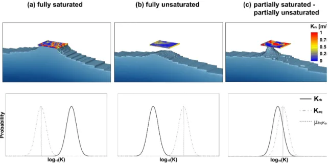
The complications that arise due to the limited information content of observations of H and QSW have been identified in a number of different contexts. Schilling et al. ((under review,
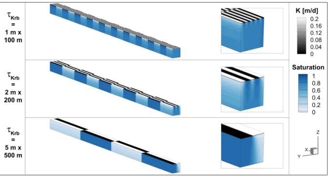
Chapter 5 of this thesis)), for example, showed that the calibration of a model of an alluvial drinking water wellfield against observations of H only resulted in non-unique combinations of hydraulic conductivity of the aquifer (Kaq), hydraulic conductivity of the riverbed (Krb) and
aquifer porosity (faq). However, the various – in terms of reproducing H – equally likely
parameter sets differed dramatically in the simulated exchange fluxes between SW and GW, and, consequently, in the mix between older GW and recently infiltrated SW pumped by the drinking water wells. Only measurements of natural tracers that informed about the source of the pumped water allowed identifying an appropriate parameter set. Similarly, Erdal and Cirpka (2016) investigated how spatially distributed Kaq and recharge (R) could be estimated
simultaneously based on observations of H alone. The study showed that only if the underlying subsurface structure was already sufficiently well-known and included in the model as prior information on Kaq, thus constraining the inverse problem and reducing the degrees of freedom,
observations of H were sufficient to reproduce the correct spatial distributions of R and Kaq
simultaneously. Without this substantial prior information on Kaq, the predictive capability of
the model was strongly impaired. Kurtz et al. (2012) also found that the information content of observations of H is insufficient to adequately characterize the different parameters of IFMs unless prior information on the subsurface structure is high: In their study, transient changes in the riverbed conductance of a river adjacent to an alluvial drinking water station could only be
reproduced through to the inclusion of prior information in the form of a well-calibrated Kaq.
Also Kerrou et al. (2008) showed the inability of observations of H to calibrate a complex transmissivity field beyond improving the simulation of H. Only the inclusion of direct observations of the transmissivity field as conditioning data for the inverse problem alongside observations of H allowed substantially improving both the simulation of H as well as the representation of the transmissivity field. These studies illustrate that the information content of H is substantial, but that complementary information which either allows constraining the water balance or directly pertains to Kaq is necessary to calibrate IFMs.
However, as already indicated previously, the inclusion of observations of QSW alongside
observations of H often is not enough to sufficiently constrain the parameters of IFMs: Ehtiat et al. (2016), for example, compared three different calibration procedures in terms of the ability of a regional SW-GW model to reproduce spatially distributed recharge. The model that best reproduced observations of H during the calibration phase was a model calibrated against H only; however, that parametrization resulted in the worst reproduction of H during a subsequent verification phase due to the inability to adequately simulate R. A better performance was only achieved once R was estimated with a separate recharge model that was individually calibrated against QSW, showing that the addition of QSW to the observation dataset
is a minimum requirement if GW and SW are simulated in a coupled way and when direct observations of the magnitude and distribution of R are non-existent. However, in a less successful attempt Doppler et al. (2014) calibrated an IFM of a regional SW-GW system against observations of H and QSW simultaneously, but the resulting model failed to accurately
reproduce the dynamics and spatial distribution of H as well as soil moisture (S). The authors suggested that the model should also be calibrated against observations of S. He et al. (2013), too, showed that observations of H and QSW are insufficient to constrain model outputs other
than H or QSW. They calibrated a flow model against observations of H and QSW with the aim
to reproduce travel times (TT) in a complex geological setting. Without substantially constraining Kaq with prior information, calibration of the model against the combined classical
observations of H and QSW only reduced the uncertainty of the simulations of H; the uncertainty
of simulations of TT, on the other hand, increased. The problem of inappropriate calibration not only pertains to the simulation and prediction of R, S or TT, neither evapotranspiration (ET) nor spatially distributed QSW can be estimated with observations of QSW obtained at the
catchment outlet and observations of H: Stisen et al. (2011b) showed this for the Ringkøbing Fjord catchment in Denmark: Calibration of a flow model against H and QSW resulted in
multiple equally-likely parametrizations in terms of their ability to simulate H and QSW. These
parameters significantly differed, however, in the simulation of R, ET and QSW at discrete
locations within the catchment. Stisen et al. (2011b) called for more and new observational data to further constrain the inverse problem and improve the water balance characterization of regional watersheds.
The general practice of limiting the calibration of IFMs to the classical observations of H and QSW is a stark contrast to the findings as discussed above, and more importantly, to the ever
increasing availability of other, unconventional observations of GW-SW systems (e.g., Healy and Scanlon (2010), Boano et al. (2014), Harvey and Gooseff (2015), Jakeman et al. (2016), Maliva (2016)). Such unconventional observation types include (but are not limited to): temperature (T), exchange fluxes (Ex) (such as SW infiltration (I), spatially distributed recharge (R), baseflow (Qbase), and GW discharge (QGW)), solute concentrations (C), residence
times (RT) and travel times (TT), evapotranspiration (ET), and soil moisture (S). Multiple recent publications suggested that including unconventional observation types in the calibration of IFMs would help to better constrain the parameters of IFMs (e.g., Anderson et al. (2015), Brunner et al. (2012), Hill and Tiedeman (2007), Simmons et al. (2012), Townley
(2012)). However, there are several challenges, potential pitfalls and unresolved issues associated with the use of unconventional observation types for the calibration of IFMs:
(1) Integration of unconventional observations into IFMs: In contrast to the classical observation types that are directly simulated by IFMs, some unconventional observations relate to processes that are often not directly simulated by default in all IFMs (e.g., heat and mass transport). The integration of unconventional observations into the IFM calibration process can be roughly separated into three approaches: (i) through an explicit simulation of the respective, additional process, (ii) through a simplified simulation procedure, or (iii) through a pre-processing/transformation of the unconventional observations into an observation type that directly relates to the advective flow simulation. Explicit simulation would provide the physically most appropriate representation of additional processes, but, as has been shown in Tab. 2.1, results in more parameters that need to be calibrated, as well as additional initial and boundary conditions that need to be known. Moreover, the explicit simulation of additional processes might result in substantially longer runtimes and harbors potential for numerical instabilities. Simplified simulation routines might provide a more efficient alternative of including additional observation types without introducing additional parameters, but could result in oversimplified physics: Flow tracking (e.g., Partington et al. (2011)) or particle tracking (e.g., Anderson et al. (2015)) schemes that track the movement of water parcels throughout the modelling domain and that allow extracting travel time information of these water parcels might, for example, be based purely on advection and ignore diffusion and dispersion. Neglecting diffusion and dispersion, however, might not always be an appropriate simplification. Similarly, transformation of unconventional observation types to more easily implementable observations prior to their integration into IFM model calibration could facilitate the use of unconventional observations, but the transformation might rely on conceptual models or simplifications that are not always justified.
(2) Calibration strategy: Which technique should be used to compare model outputs to unconventional observations, and how should the model parameters be calibrated? Should model parameters be calibrated (i) step-wise with multiple single-variable objective functions, where one parameter is first calibrated against one type of observation and then another parameter against another type of observation and so on, or should model parameters be calibrated (ii) simultaneously with one single weighted multi-variable objective function? Step-wise calibration with multiple single-variable objective functions is likely to result in a local minimum solution of the first parameter that is calibrated, impairing an appropriate calibration of the following parameters (Townley, 2012). Simultaneous calibration of all model parameters against all available observations with s single weighted multi-variable objective function, on the other hand, protects against this; finding the most appropriate weighting scheme for a simultaneous calibration of all parameters against all available observations, however, is often not straightforward (e.g., Anderson et al. (2015), Doherty and Welter (2010), Hill and Tiedeman (2007), Townley (2012), Voss (2011b)).
(3) Weighting of different observations: Whether model parameters are calibrated step-wise or simultaneously, one either needs to decide on which observation type to use first (for a step-wise calibration) or on how to weight the different observation types in a multi-variable objective function (for a simultaneous calibration). Both parameters and observations need to be weighted according to their importance as well as
according to their uncertainty. Weighting different observation types, however, is not straightforward, as the different observation types might strongly vary in number, accuracy as well as on their coverage of spatial and temporal scales (Doherty and Welter, 2010). Depending on the calibration order in case of step-wise calibration, or on the weighting scheme in case of simultaneous calibration, very different sets of calibrated parameters can result.
Following from the outlined limitations using classical observations alone, and potential pitfalls associated with the use of unconventional observations, the aim of this review is to analyze the current state of using unconventional observation types in the calibration of IFMs. Moreover, the specific goals of this review are (i) to review how different types of unconventional data were used and to what extent they could improve the model (ii) to identify the methods that allowed to successfully include unconventional observations in the calibration of a flow model, and, if the available literature allows it, (iii) to investigate the worth of different unconventional observation types in calibrating flow models, and (iv) to identify current research needs.
2.2. Review of unconventional observation types
2.2.1. Review strategy
The review was limited to studies that used unconventional observations for the calibration of IFMs of a comparably large scale, with the smallest models having the spatial extent of a contaminant plume. One additional, synthetic study at the scale of an aquifer column was also included in this review, as a very extensive data worth and uncertainty analysis was applied. An overview over the reviewed studies is provided in Table 2.2: The table provides information about the study type, the employed observation types, the simulated processes, the modeling codes, the horizontal scale, as well as, the calibration and uncertainty estimation method. The review is grouped by how an unconventional observation is used in the calibration procedure of an IFM, rather than reflecting the method of how the observation was obtained. Residence times, for example, cannot be measured directly but are inferred from tracer concentrations. The use of residence times in flow model calibration nonetheless is discussed in a section separate from the section on the use of solute concentration observations.