HAL Id: insu-01138548
https://hal-insu.archives-ouvertes.fr/insu-01138548
Submitted on 14 Oct 2015
HAL is a multi-disciplinary open access
archive for the deposit and dissemination of
sci-entific research documents, whether they are
pub-lished or not. The documents may come from
teaching and research institutions in France or
abroad, or from public or private research centers.
L’archive ouverte pluridisciplinaire HAL, est
destinée au dépôt et à la diffusion de documents
scientifiques de niveau recherche, publiés ou non,
émanant des établissements d’enseignement et de
recherche français ou étrangers, des laboratoires
publics ou privés.
Distributed under a Creative Commons Attribution - NonCommercial - NoDerivatives| 4.0
International License
Coupled tectonic evolution of Andean orogeny and
global climate
Rolando Armijo, Robin Lacassin, Aurélie Coudurier-Curveur, Daniel Carrizo
To cite this version:
Rolando Armijo, Robin Lacassin, Aurélie Coudurier-Curveur, Daniel Carrizo. Coupled tectonic
evo-lution of Andean orogeny and global climate. Earth-Science Reviews, Elsevier, 2015, 143, pp.1-35.
�10.1016/j.earscirev.2015.01.005�. �insu-01138548�
Coupled tectonic evolution of Andean orogeny and global climate
Rolando Armijo
a,c,⁎
, Robin Lacassin
a,c, Aurélie Coudurier-Curveur
a,c, Daniel Carrizo
b,ca
Institut de Physique du Globe de Paris, Sorbonne Paris Cité, Univ Paris Diderot, UMR 7154 CNRS, F-75005 Paris, France
b
Advanced Mining Technology Center, Universidad de Chile, Tupper 2007, Santiago, Chile
cLaboratoire International Associé Montessus de Ballore (LIA MdB) CNRS (France)-CONICYT Chile
a b s t r a c t
a r t i c l e i n f o
Article history: Received 28 March 2014 Accepted 19 January 2015 Available online 29 January 2015 Keywords: Orogeny Climate Andes Subduction Tectonics Geomorphology
The largest tectonic relief breaking the Earth's surface (13 km vertically) is at the subduction margin of the Andes, which generates routinely megathrust earthquakes (MwN 8.5) and drives the paradigmatic Andean orogen. Here we present key geologic evidence to reassessfirst-order features of geomorphology and tectonics across the Central Andes, where the orogen includes the Altiplano Plateau and attains its maximum integrated height and width. The Andean subduction margin has a stepped morphology dominated by the low-relief Atacama Bench, which is similar to a giant uplifted terrace, slopes gently over a width of 60–100 km from the Andes to the Pacific, and runs over more than 1000 km of coastal length. We find that the genesis of stepped morphology at the Andean seaboard is due to concomitant development of large west-vergent thrusts parallel to the subduc-tion interface and increasing aridity in the Atacama Desert, which keeps an unprecedented large-scale record of interplaying tectonics and Cenozoic climate change. Incorporating our results with published geological knowl-edge demonstrates that Andean orogeny is characterized by perpendicular (bivergent) and trench-parallel (bilateral) growth over the past 50 Myr, associated with positive trench velocity toward the continent (trench advance) and subduction of a wide slab under South America. We hypothesize that a global plate tectonic reorganization involving long-lasting viscous mantleflow has probably forced both, Andean orogeny and global climate cooling since ~ 50 Ma. In contrast, two important stepwise pulses of increasing aridity and trench-perpendicular Andean growth appear to be results of changes in erosion rates due to global Late Eocene and Middle Miocene cooling events.
© 2015 The Authors. Published by Elsevier B.V. This is an open access article under the CC BY-NC-ND license (http://creativecommons.org/licenses/by-nc-nd/4.0/).
Contents
1. Introduction . . . 2
2. The Atacama Bench . . . 3
2.1. Topography and morphology of the Andean margin: Atacama Bench and major structural discontinuities . . . 3
2.2. Late Cenozoic evolution of the Atacama Bench: central depression basin between two pediplains . . . 5
2.3. Climatic change indicated by Choja Pediplain, at the base of the CDB . . . 10
3. Hidden structure of Western Cordillera:“Incaic” backbone under Choja Pediplain . . . 10
3.1. Structure at westflank of the Andes: Pre-Andean, Early Andean and Late Andean tectonics . . . 10
3.2. Accretion of Andean structural basement during assembly of Gondwana . . . 10
3.3. Andean structural cycle during dispersal of Gondwana: from spreading to contraction of Andean subduction margin . . . 12
3.3.1. Early period . . . 14
3.3.2. Transitional period . . . 15
3.3.3. Late period: overview of Andean orogeny at subduction margin . . . 16
3.4. Uncovered structures in Cordillera Domeyko: the West Andean Thrust (WAT) . . . 16
4. West of Atacama Bench: structures controlling coastline and seismic coupling . . . 17
5. Discussion: evolution of the Andean orogen . . . 17
5.1. Incorporating tectonic features of the subduction margin with main features of the Andean orogen . . . 17
5.2. Approach for reconstructing a 2D evolution . . . 19 Earth-Science Reviews 143 (2015) 1–35
⁎ Corresponding author. Tel.: +33 1 83957607. E-mail address:[email protected](R. Armijo).
http://dx.doi.org/10.1016/j.earscirev.2015.01.005
0012-8252/© 2015 The Authors. Published by Elsevier B.V. This is an open access article under the CC BY-NC-ND license (http://creativecommons.org/licenses/by-nc-nd/4.0/).
Contents lists available atScienceDirect
Earth-Science Reviews
5.3. Initial status . . . 22
5.4. Snapshot at 40 Ma: deformation localized in Western Cordillera . . . 22
5.5. Snapshot at 30 Ma . . . 23
5.5.1. Completion of Choja Pediplain over Western Cordillera: tectonic vs. climatic forcing . . . 23
5.5.2. Late Eocene–Early Oligocene Andean growth by widening . . . 23
5.6. Snapshot at 20 Ma: continuing deformation between Western Cordillera and Interandean belt . . . 23
5.7. Snapshot at 10 Ma: preparation for subduction of the Brazilian Shield . . . 23
5.8. Present-day status: Late Miocene Andean growth by widening . . . 24
5.9. Comparison of our interpreted section with earlier models . . . 24
6. Andean orogeny in concert with plate tectonics and Cenozoic climate change . . . 26
6.1. Plate tectonics as possible long-period forcing of Andean orogeny and global cooling . . . 28
6.1.1. Climate, plate tectonics and Andean tectonics . . . 28
6.1.2. Effects of plate tectonic evolution and possible boundary conditions since 50 Ma . . . 28
6.2. Possible climatic feedbacks on Andean growth process . . . 28
7. Conclusions . . . 30
Acknowledgements . . . 31
References . . . 31
1. Introduction
The Himalayas–Tibet and the Andes–Altiplano – the largest active mountain belts creating relief in our planet– have been caused by rad-ical changes in plate-boundary conditions. In both cases, subduction of oceanic lithosphere beneath an initiallyflat continental margin, close to sea-level, evolved to critical tectonic conditions triggering substantial shortening and thickening of marginal continental lithosphere, either by continental collision or by an equivalent process producing similar effects. Therefore, deformation should be similarly partitioned between elastic deformation generating routinely megathrust earthquakes and distributed deformation accumulating over millions of years in the marginal continent. Mechanical coupling and structure of the plate in-terface in the two cases should be comparable as well. However, while the India–Asia continental collision zone appears to be a structurally complex interface between subducting continental lithosphere and a deforming continental region (e.g.Molnar and Lyon-Caen, 1988; Avouac, 2003; Grandin et al., 2012), the subduction margin of South America is generally assumed to be a simple subduction interface be-tween a plunging oceanic slab and a non-deforming continental forearc (e.g.Uyeda and Kanamori, 1979; Isacks, 1988).
Here we present results from a study of the Andean subduction mar-gin and its evolution to conditions sustaining the Andean orogeny, over a range of scales in space and time. Our approach integrates key geo-morphological and geological observations along the Central Andean subduction margin with a critical review of the literature. It is aimed at solving threefirst-order problems. The first one is to define specific structural characteristics and degree of complexity of the Andean sub-duction margin (representing 13 km of vertical tectonic relief), enabling us to establish a tectonic comparison with the Himalayan margin, and to elucidate how the growing marginal relief of the Andes can be support-ed by crustal shortening and thickening in the overriding South America plate. The second objective is to usefirst-order constraints obtained from the climatically-controlled aspects of the geomorphology and ge-ology of the subduction margin– which is characterized by the imprint of the Andean tectonic landscape in the Atacama Desert– to reconstruct an overall section of the Andean orogen, allowing us to elucidate its tec-tonic and morphologic growth processes over the continent. Our third goal is to address possible relationships of Andean orogeny with plate-scale tectonic evolution and global climate change.
Earlier studies of upper crustal structure (down to ~ 15 km depth and mainly conducted with seismic sounding approaches) demonstrate that the Central Andes (Andes–Altiplano Plateau, core of the Andean orogen) have grown during the Cenozoic by crustal shortening (of up to ~N 300 km) and thickening processes, associated with signif-icant east-directed thrusting along its eastflank, toward the continent (e.g.Suárez et al., 1983; Sheffels, 1990; Kley et al., 1999; Elger et al.,
2005; McQuarrie et al., 2005; Barnes and Ehlers, 2009; Whipple and Gasparini, 2014) (Figs. 1 and 2). The surface geology shows also that crustal shortening started at ~ 50–30 Ma close to the subduction zone associated with west-directed thrusting in the Western Cordillera, then propagated progressively away from the subduction zone,first by a jump (at ~40 Ma) to the Eastern Cordillera, then since ~10 Ma to the easternmost Subandes Belt (Sempere et al., 1990; Allmendinger et al., 1997; Gregory-Wodzicki, 2000; McQuarrie et al., 2005; Oncken et al., 2006; Arriagada et al., 2008; Barnes and Ehlers, 2009; Carrapa et al., 2011; Charrier et al., 2013). Shortening of the Altiplano Plateau occurred later (since ~ 30 Ma:Sempere et al., 1990; Elger et al., 2005; Oncken et al., 2006)– and is less (as shown by crustal thickness of ~ 70 km)– than in the two flanking Western Cordillera and Eastern Cordillera belts, which are both sustained by deeper crustal roots (~ 74–80 km thickness) (Yuan et al., 2000; Wölbern et al., 2009). The most accepted view of Andes crustal thickening describes the orogen as a large back-arc thrust wedge transported upon the adjacent conti-nent (South America), with subsidiary tectonic activity– accretionary or non-accretionary– in the fore-arc (e.g.Stern, 2002; Lamb and Davis, 2003; McQuarrie et al., 2005). That view is readily comparable to the par-adigmatic description of the Cordilleran Belt of North America. However, it has been recently argued that much like the Himalaya–Tibet Plateau (core of the Himalayan orogen), the structure of the Central Andes is symmetrically bivergent (Armijo et al., 2010a), as suggested earlier by (Sheffels, 1990; Haschke and Gunther, 2003; Elger et al., 2005). In this work, we explore the hypothesis that continued support of the Andean orogen, particularly the uplift and crustal thickening processes under the Western Cordillera, could be kinematically coupled with the subduc-tion interface, with the same westward vergence. That hypothesis differs from current kinematic models suggesting that deformation of the An-dean subduction margin would depend only upon processes at the east-ernflank of the orogen (e.g.Isacks, 1988; McQuarrie et al., 2005; Jordan et al., 2010; Lamb, 2011). Another accepted description states that Ande-an deformation has progressed by widespread synchronous pulses (or phases: e.g. Noble et al., 1979; Coira et al., 1982; Mégard, 1984; Charrier et al., 2007). However, crustal contraction has propagated not only across the Andean belt, but also laterally by southward trench-parallel growth of the Western Cordillera, as indicated by ages of defor-mation younging southwards to the latitude of Santiago, where shorten-ing started at ~25 Ma (e.g.Armijo et al., 2010a) (Fig. 1). In this work, we explore the hypothesis that shortening processes in the Andean orogen are basically diachronic.
Our study strategy starts by analysingfirst-order features at the leading edge of the Andean subduction margin, where the Cenozoic ge-ology and morphge-ology are marked by the widespread occurrence of the Atacama Desert (here the Atacama Desert concept includes the Sechura Desert of southern Peru). The approach is centred on determining the
processes that developed a large-scale, low-relief surface perched on the westflank of the Western Cordillera, along the Andean margin (Fig. 3), which we denote here as the Atacama Bench.
Morphologically, the Atacama Bench has the shape of a giant terrace 1–2 km high that stretches over a length of more than 1000 km, mantled by sediment and sloping gently oceanward (b1°) (Figs. 2 and 3). The northern part of the Atacama Bench is incised by deep canyons, suggesting substantial tectonic land uplift (Mortimer, 1973; Tosdal et al., 1984; Sébrier et al., 1988; Schlunegger et al., 2006; Schildgen et al., 2007; Thouret et al., 2007). However, it has for long been believed that tectonic uplift of coastal regions, as described in north Chile, is rela-tively old (of Oligocene–early Miocene age) and de-correlated from younger incision processes, which would be controlled by wetter climate conditions (Mortimer and Saric, 1975; García et al., 2011). Here we ana-lyse the morphological and structural characteristics of the Atacama Bench, to distinguishfirst-order observations and revise interpretations to characterize the interplay of tectonic evolution with Cenozoic climate change throughout the Pacific seaboard of the growing Andean orogen. Structurally, the Atacama Bench appears to be bounded by fault sys-tems at theflank of the Western Cordillera and offshore near the coast-line (Fig. 2), but the nature and significance of those structures are unclear and a subject of controversy (e.g. seeAstini and Dávila (2010) vs.Armijo et al. (2010b)). Here we analyse the structure of the Western Cordillera, which encompasses what appears to be its hidden backbone (an earlier mountain range called“Incaic” range (Charrier et al., 2013)) that is truncated by a widespread erosion surface (Choja Pediplain (Galli-Olivier, 1967)) and covered by unconformable younger deposits (~≤ 30 Ma) (Fig. 4). We hypothesize that the Atacama Bench and the hidden structure of the Western Cordillera are to scale with the subduc-tion margin of the Central Andes and so can help retrieving primary quantitative constraints on the Andean orogeny and climate change.
We use the high-resolution coverage of topography provided by the Shuttle Radar Topography Mission (standard SRTM3 with 90 m
resolution) and recent compilations of topography with bathymetry compilation designated SRTM 30 + with 900 m resolution (Becker et al., 2009), allowing us to define major morphological units composing the subduction margin of the Central Andes and to elucidate the struc-tural framework of the Atacama Bench explaining its uplift. Then, we in-corporate geomorphic results with a review of geological information and with newfield-based observations of structure targeted at key areas of the hidden“Incaic” backbone of the Western Cordillera.
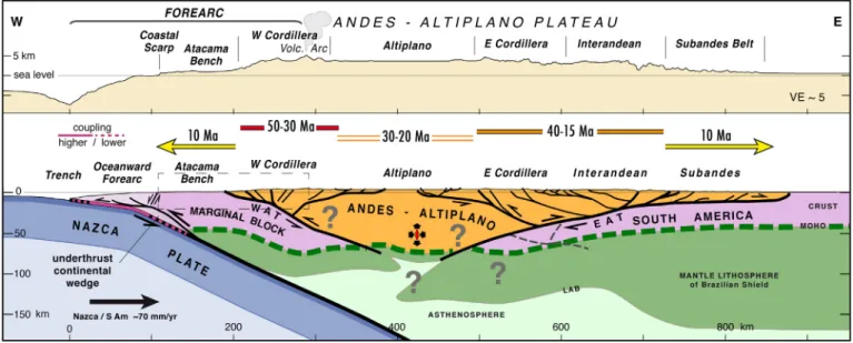
The second step of our strategy is to incorporate our results on the Andean subduction margin with relevant data on Andean geology and geomorphology, which enables us to conduct a reassessment of the tec-tonic–climatic evolution of the Andean subduction margin throughout the late Cenozoic and to construct a simple 2D section of modern struc-tural features at latitude 21°S to scale with crustal shortening and thick-ening throughout the core of Andean orogen. An important condition for that model is consistency with present-day coupling processes across the plate boundary and generation of megathrust earthquakes.
Finally, at the larger scale, we discuss how our 2D evolutionary re-sults on the subduction margin and across the core of the Andean orogen can be extended latitudinally over the deforming margin of South America, then incorporated with a selective review of current knowledge of Andean boundary conditions, plate-scale tectonics and climate change. With this approach, we propose a new unifying concept of Andean orogeny.
2. The Atacama Bench
2.1. Topography and morphology of the Andean margin: Atacama Bench and major structural discontinuities
The Central Andes form a characteristic bend, named here Andean Orocline (Bolivian orocline ofIsacks (1988)), which is marked on the coastline of South America by a kink at Arica, close to the Peru–Chile
Fig. 1. The Andean orogen. (a). Tectonic framework of Central Andes, with bend at Arica marking the hinge of Andean Orocline (Isacks, 1988)). Extent of orocline is outlined (between 7°S and 33°S). (b). Enlarged topography of orocline region (located by red corners in a) with outline of main mountain belts. Trench-parallel double arrows indicate location and easterly de-creasing extent of Western Cordillera (WC, red), Eastern Cordillera (EC, orange) and Subandes Belt (SB, yellow), associated with development of Andean Orocline. AP is Altiplano Plateau. The bivergent trench-perpendicular orogenic growth (yellow arrows) is constrained by the decreasing age of shortening across the orogen: compare the main shortening ages at the centre of the WC (50–30 Ma, in Mega Annum) with the age of shortening propagation to the SB (10 Ma) and the coeval initiation of the uplift of the Atacama Bench (AB). The trench-parallel (lateral) orogenic growth is indicated by the southward and northward decrease in the amount of shortening across the orogen (with respect to the Andean Orocline hinge) and by the southward decrease of shortening initiation age along the WC: compare ages at the central WC (50–30 Ma at 20°N) with ages in the southern WC (25 Ma at 35°S). Segmented black lines with triangular ticks represent main bivergent mountain fronts. The trace of the section inFig. 14is given. The Nazca/South America horizontal convergence vector is from NUVEL-1A model (DeMets et al., 1994). Li is Lima; Ar, Arica; Sa, Santiago. (For interpretation of the references to colour in thisfigure legend, the reader is referred to the web version of this article.)
3 R. Armijo et al. / Earth-Science Reviews 143 (2015) 1–35
border (Figs. 1, 2 and 3). To examine the morphological features of the Andean margin (Figs. 5–7), our analysis of topography uses swath-profiles constructed along and across the strike of the two limbs of the Andean Orocline (North Chile and South Peru). The two sides of the Arica bend are covered conveniently, enhancing features at the larger scale, by constructing“wide-swath” images (Figs. 5b-c and 6b-c) com-posed of a series of≥500 km-long trench-parallel profiles scanning the land and seafloor topography over a significant width of the margin (~≥ 350 km), using SRTM 30+ data (incorporating bathymetry) with resolution of 30 arc seconds (~900 m) (Becker et al., 2009). The same “wide-swath” technique is applied to capture details of the onshore morphology with trench-parallel profiles scanning a width of ~≥200 km (Figs. 5d and6d) and using more accurate SRTM3 data
with 3 arc seconds resolution (~90 m). To crosscut information, a series of trench-perpendicular ~ 500 km long swath-profiles (Fig. 7) are fo-cused on selected sections (see location inFig. 2) across the Andean margin over a reduced width of a few tens of km in the SRTM 30+ data. Broad orogen-scale characteristics of the topography (Figs. 5–7) are as follows: (1) The total relief of more than 13 km from the summits of the Western Cordillera (≥5000 m elevation) to the depths of the trench axis (~8000 m depth) appears to be a 250-km-wide upwarping of the wholesale Andean margin (with ~ 3° of average slope). That upwarping represents a large-scale steep gradient, comparable to the (8 km high, 150-km-wide, also with ~3° of average slope) topographic scarpflanking the Himalayas. (2) The west Andean upwarping is howev-er broken into aflight of steps, which represent low-relief morphologies,
Fig. 2. Geological sketch map of Andean orogen. The main morphological–structural units of the bivergent Central Andes (continental region with over-thickened crust constituting the core of the Andean orogen) are represented within horizontal boundary conditions (converging Nazca and South America plates). Plate convergence vector is from NUVEL 1-A model (DeMets et al., 1994). Tectonic units of the trenchward verging Andean Subduction Margin (fore-arc) are specified. The Atacama Bench is on top of the pre-Cenozoic basement of the rigid Marginal Block. The Atacama Bench is bounded to the East by the West Andean Thrust (WAT), whichflanks the Western Cordillera and is a major mechanical boundary with the same vergence as the subduction zone (Armijo et al., 2010a). To the West of the Atacama Bench are the Arequipa Basin (AqB), Arica Basin (ArB) and Iquique Basin (IqB), which form a trench-parallel string on the oceanward forearc (Coulbourn and Moberly, 1977). The overall structure across the orogen (displaying all units and structures depicted here) is shown in the section displayed inFig. 14. Its trace is indicated here in red at 21°S latitude. Also, the imprint of trench-perpendicular swath profiles and interpretations discussed in
Fig. 7(P1–P3; C1–C3) are located by elongated rectangles labelled in red. Finally, the bold red rectangles locate the detailed tectonic maps (Figs. 9 and 12). (For interpretation of the ref-erences to colour in thisfigure legend, the reader is referred to the web version of this article.)
having evolved for a significant period of time with a stable base level. The two most prominent steps are the onshore Altiplano Plateau and Atacama Bench, respectively at ~4000–4500 m and ~1000–2000 m ele-vation. (3) The Atacama Bench emerges clearly as a fundamental tectonic unit at the same scale as the Altiplano Plateau and the Andean Orocline. (4) The third step is a terrace on the oceanward forearc at ~400–1600 m depth, beneath which modern sedimentation has accumulated in back-tilted basins forming a trench-parallel string (Coulbourn and Moberly, 1977). (5) As demonstrated later (Sections 3 and 4), two major structur-al discontinuities, or fault systems, appear to form the main boundaries (between the Altiplano Plateau and the Atacama Bench, as well as be-tween the Atacama Bench and the terrace in the oceanward forearc) and control the development of theflight of steps.
2.2. Late Cenozoic evolution of the Atacama Bench: central depression basin between two pediplains
Using the available geological evidence, it is possible to define basic features of the Atacama Bench down to some depth and to decipher its structural evolution (Fig. 8), which appears closely associated with the Cenozoic evolution from semi-arid to extremely arid conditions in the Atacama Desert (e.g.Jordan et al. (2014)). The top of the Atacama Bench corresponds to theflat west part of an extensive climatically-controlled erosion surface called Atacama Pediplain (e.g. (Hartley and Evenstar, 2010)), which slopes down westwards from elevations of ~≥3000 m on the flank of the Western Cordillera to elevations of ~ ≤1000 m atop the Coastal Cordillera. Beneath the Atacama Pediplain is a continental wedge-shaped forearc basin, called the Cen-tral Depression Basin (CDB), which has formed over the west piedmont
of the Andes in the Late Eocene–Late Miocene (from ~30 to ~10 Ma) and is considered of foreland type (Victor et al., 2004; Hartley and Evenstar, 2010). The CDB isfilled with a sedimentary pile (up to ~1.5 km thick) grading eastward into coarse grained alluvium derived from the West-ern Cordillera and large ignimbriteflows erupted from the Miocene vol-canic arc (Farías et al., 2005; Hartley and Evenstar, 2010; Schlunegger et al., 2010).
In more stratigraphic detail, the Central Depression Basin started to develop with deposition of the Oligocene Azapa formation (Charrier et al., 2007), roughly correlated with the late Eocene–early Miocene Moquegua group in South Peru (Sébrier et al., 1988; Thouret et al., 2007). It has been shown that in some places the latter group may ex-tend up through the late Miocene or even the Pliocene (Roperch et al., 2006). However, most of the sediments associated with the Azapa for-mation and the Moquegua group (units designated Moquegua A and Moquegua B by (Roperch et al., 2006)) appear clearly followed by dom-inant emplacement of volcanic ashes and lavaflows that cover much of the landscape, which generally group into the late Oligocene–middle Miocene Oxaya formation (also termed Oxaya ignimbrites) (Muñoz and Charrier, 1996; Charrier et al., 2007; Schlunegger et al., 2010), and roughly correlated with plateau-forming ignimbrites called collectively Huaylillas ignimbrites in South Peru (Sébrier et al., 1988; Thouret et al., 2007). Then, over the large ignimbrite units is the early-middle Miocene El Diablo formation (Charrier et al., 2007), which may extend up into the late Miocene (Schlunegger et al., 2006). The El Diablo Formation of northern Chile can be roughly correlated with the Chuntacala Formation in South Peru, (Sébrier et al., 1988). Since ~ 14 Ma (middle Miocene), deposition of gravels associated with minorfluvial reworking and climate change (Evenstar et al., 2009) appears to have led to progressive
Fig. 3. Atacama Bench within over Andean subduction margin. Oblique 3-D display (GoogleEarth) of main units of the Andean orogen emphasizing the trenchward downwarping and stepped morphology of the subduction margin. View is southeastward. The position of the modern volcanic arc and the extent of the forearc are outlined. On the landward forearc, the flat Atacama Bench (yellow) is geologically similar to a giant terrace, overprinting the warped Central Depression Basin (brown), which extends farther inland and drapes the flanks of the Western Cordillera. The oceanward forearc is characterized by a terrace over a string of basins (Arequipa, ArB; Iquique, IqB; and Arica, ArB) (Coulbourn and Moberly, 1977), represent-ed by two tones of light blue. A quantitative analysis of the margin's topography is given inFigs. 5–7. (For interpretation of the references to colour in thisfigure legend, the reader is re-ferred to the web version of this article.)
5 R. Armijo et al. / Earth-Science Reviews 143 (2015) 1–35
completion and eventual abandonment of the Atacama Pediplain (e.g.Evenstar et al. (2009);Jordan et al. (2014)). Dated ashes intercalat-ed within the uppermost gravels reworking the El Diablo Formation indicate ages as young as 5–6 Ma, both in northern Chile and South Peru (Sáez et al., 1999; Hoke et al., 2007; Schildgen et al., 2009). Howev-er, in contrast with the climatically-controlled development of the Atacama Pediplain, its abandonment appears to be associated with a significant tectonic change, involving canyon incision and land uplift (which is discussed later in this section).
The evolution of the Central Depression Basin and the eventual es-tablishment of the Atacama Bench recorded the climate evolution to-ward the present-day hyper-aridity in the Atacama Desert (≤5 mm/yr of precipitation) and more generally the climate change over the
western seaboard of central South America (seesection 2.3and discus-sions byHartley and Chong (2002);Hartley et al. (2005);Rech et al. (2006);Rech et al. (2010);Amundson et al. (2012); Jordan et al. (2014)). An important piece of evidence on the passage from aridity to hyper-aridity comes from studies of supergene enrichment in porphyry-copper deposits in North Chile (Alpers and Brimhall, 1988; Sillitoe and McKee, 1996; Arancibia et al., 2006), which indicate erosion and thus precipitation rates significantly decaying after 14 Ma, coevally with a global cooling event of the Cenozoic (Zachos et al., 2008) and with the intensification of a cold upwelling Peru–Chile Current between 15 and 10 Ma (see discussions byGregory-Wodzicki (2000);Houston and Hartley (2003)). That correlation would be stratigraphically signed by the end of significant sediment deposition (El Diablo formation)
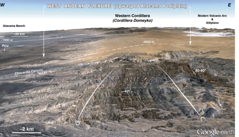
Fig. 4. Hidden“Incaic” structure of Western Cordillera under flexured Choja and Atacama Pediplains. Oblique 3-D display (GoogleEarth) showing the “frozen” folded structure of the Western Cordillera (northern Cordillera Domeyko area) under the west Andean monoclineflexure affecting the pediplains. The Atacama Pediplain tops the Early Oligocene–Late Miocene sedimentary/volcanic pile deposited in the Central Depression Basin (seeFig. 8). Under those deposits is Choja Pediplain marking the sharp unconformity over the west-vergent folded Mesozoic rocks of the composite early Jurassic–late Palaeocene Andean Basin. Three first-order features of Andean orogeny are identified spectacularly: (1) The main period of tectonic shortening and basement exhumation across the Western Cordillera (late Palaeocene–Eocene, between 50 Ma and 30 Ma); (2) The effects of increased aridity in the earliest Oligocene (~33 Ma) throughout the Pacific seaboard of central South America; (3) The effects of hyper-aridity since the Late Miocene abandonment of Atacama Pediplain (~10 Ma). View is north-ward. Chacarilla Canyon is in the middle ground; Pica and Atacama Bench in the background to the left. Geology of the area is depicted inFigs. 9 and 10.
Fig. 5. Trench-parallel topography along Andean subduction margin— North Chile.Figs. 5 and 6are intended to describe the major morphological features of the Central Andes margin on the two limbs of the Andean Orocline (Isacks, 1988) (covering the two sides of the Arica bend, seeFigs. 1, 2 and 3). So, the continuity of those features can by visualized. (a). 3D front view to the East of the area described, using Shuttle Radar Topography Mission SRTM 30+ data (Becker et al., 2009) to produce the N–S wide-swath profile below. The Arica bend is to the left. The upwarping of the Andean margin is clearly visible, as well as its main steps, indicated with red characters: Altiplano Plateau and Atacama Bench. An overlay with two tones of light blue (according to sediment thickness) indicates the offshore step constituted by a terraced string of basins including the Arica Basin. (b). Wide-swath profile scanning systematically the topography shown in the 3D view. The image is obtained by stacking a series of N–S profiles sampling at full resolution (each 30 arc seconds) between 18°S–25°30′S and 72°W–67°26′ W). Vertical exaggeration is VE = 7.5. (c). The interpretation of the image in (b) describes the main morphological features of the margin extending down to latitude 23°S (Mejillones Peninsula–Salar de Atacama), south of which variations in the structural style of the Central Andes, clearly distinguishable in the topography, are beyond the scope of this study. The Mejillones Peninsula is a morphological singularity of the margin, representing a structural complexity of the overriding continental plate associated with segmentation of earthquake rupture at the subduction interface (Béjar-Pizarro et al., 2010). Red characters indicate Altiplano Plateau (AP), Atacama Bench (AB, in yellow), Arica Basin (ArB) and Iquique Basin (IqB). Features below sea level are in dark blue, except basins in the step close to the coastline (light blue). The warped sedimentary and volcanic units of the Central Depression Basin (in orange) conceal largely theflank of the Western Cordillera, except in Cordillera Domeyko. The red frame indicates the location of the close-up below. (d). Close-up of onshore topog-raphy using the same wide-swath technique and SRTM3 data (with 3 arc seconds resolution). The stacked image includes most of the area covered by the map inFig. 9. The red trapezoid encompasses approximately the aerial view displayed inFig. 11a. The modern volcanic arc is clearly seen in the background, above theflat surfaces of the Altiplano Plateau and the Atacama Bench (yellow enhancement). The canyonsflowing down from the Altiplano Plateau (Chacarilla, Guatacondo and Mani) cut across the west flank of Cordillera Domeyko, where the west-vergent thrust structure crops out (Figs. 4 and 9-11). At the lower course of Loa river a 1-kilometre deep canyon is incised across the Atacama Bench. The equally high area of the image facing the sea in the foreground (in shade) is the Coastal Scarp (CS). (For interpretation of the references to colour in thisfigure legend, the reader is referred to the web version of this article.)
7 R. Armijo et al. / Earth-Science Reviews 143 (2015) 1–35
and pedimentation processes (Atacama Pediplain) topping the CDB, be-fore its entrenchment by canyons (seeFig. 8). However, the gradual evolution to hyper-aridity starting in the Middle Miocene appears to in-cludefluctuations and a further Pliocene hyper-aridity increase (Hartley and Chong, 2002; Allmendinger et al., 2005; Hartley et al., 2005; Rech et al., 2006; Rech et al., 2010; Amundson et al., 2012; Jordan et al., 2014), which could be associated with a relatively warm Pliocene sea surface temperature along the Peruvian coast (Dekens et al., 2007; Jordan et al., 2014).
At the base of the Central Depression Basin is a regional erosion surface named Choja Pediplain (Galli-Olivier, 1967) (seeSection 2.3). Under that surface are previously deformed sedimentary and mag-matic rocks associated with a thick (≥10 km thick) proto-Andean Mesozoic arc and back-arc basin system (early period of the Andean cycle) deposited on top of Palaeozoic and Precambrian metamorphic rocks (Mpodozis and Ramos, 1989; Sempere et al., 2002; Charrier et al., 2007; Schildgen et al., 2009) (Fig. 8). It has been suggested that the ensemble formed by the Mesozoic magmatic arc embedded in Palaeozoic and older basement rocks constitute the cold rigid basement of the crustal-scale Marginal Blockflanking the Western Cordillera for several thousand kilometres (Armijo et al., 2010a) (Figs. 2 and 7). The structure defining the boundary between the Western Cordillera and the Marginal Block (so possibly explaining the topographic step between the Altiplano Plateau and the Atacama Bench, seeFigs. 7 and 8) would correspond to the major West Andean Thrust (WAT) (Armijo et al., 2010a, 2010b). However, the topography of the Central Andes margin indicates another continuous step near the coastline be-tween the Atacama Bench and the oceanward forearc (Fig. 7), which calls for a structural explanation.
Basic features to constrain evolution of the Central Depression Basin are the following. In South Peru, the CDB preserves an intercalated marine sediment layer 25 Myr old (Thouret et al., 2007), indicating sedimentation at that time in the Andes piedmont has occurred at low level, close to the oceanic base level. The marine layer is now found close to theflank of the Western Cordillera ~50 km inland from the coast, at ~ 2000 m elevation (Tosdal et al., 1984; Sébrier et al., 1988; Thouret et al., 2007; Schildgen et al., 2009) (location inFig. 12), beneath the surface of the Atacama Bench, which is now incised by a series of deep canyons grading down to the Ocean from headwaters in the Altiplano Plateau and the Western Cordillera (Figs. 3–6).40Ar/39Ar age
determinations (Thouret et al., 2007) and apatite (U–Th)/He thermo-chronology data (Schildgen et al., 2009) imply at least 2.4–3 km of river incision by those canyons after ~ 9 Ma (in the Cotahuasi-Ocoña river) (Schildgen et al., 2009; Schildgen et al., 2010). Those observations require a minimum of 1.4–2 km of differential uplift of the Western Cordillera with respect to the Atacama Bench and ~ 1 km of overall land uplift with respect to the oceanic base level (Atacama Bench coupled with Western Cordillera and Altiplano Plateau) (Schildgen et al., 2009), driving the incision of canyons.Schildgen et al. (2009) discussed two distinct phases of incision, thefirst through the Western Cordillera, and the later through the Atacama Bench and the coastal re-gion. In North Chile, similar canyons have been incised headwards from the Pacific across the Atacama Bench as much as 1 km after 11 Ma, or more recently (Schlunegger et al., 2006; Schlunegger et al., 2010; García et al., 2011; Kirk-Lawlor et al., 2013), suggesting significant (~0.6 to 1 km) land uplift relative to the oceanic base level, consistent with the occurrence of the spectacular 1-km-high Coastal Scarp (Armijo and Thiele, 1990) (Fig. 10), and with observations of lower-level sets of glacio-eustatic marine platforms and terraces testifying to
late Pleistocene coastal uplift (e.g.Armijo and Thiele (1990);Ortlieb et al. (1996);Marquardt et al. (2004);Regard et al. (2010)).
In stark contrast with the evidence in South Peru, it has for long been considered that uplift of coastal regions in North Chile would be independent and much older (Cretaceous–Palaeocene; ~ ≥ 25 Ma) than the post-Late Miocene (~ ≤ 11 Ma) incision of canyons (Mortimer and Saric, 1975; Farías et al., 2005; García et al., 2011). How-ever, the hypothesis of old uplift (~≥ 25 Ma) appears controversial (Schildgen et al., 2007; Schlunegger et al., 2010). In principle, the onset of incision is not necessarily triggered by surface uplift, because it could be also a response to climatic change (Alpers and Brimhall, 1988; Gregory-Wodzicki, 2000). Following the hypothesis of old uplift (~≥ 25 Ma) and subsequent incision,García et al. (2011)suggested that canyon incision across the Atacama Bench could have been trig-gered during the Late Miocene–Pleistocene (~ ≤ 11 Ma), which would be a period of prevalent hyper-aridity, by a runoff increase associated with possible local pulses of semi-aridity. There is limited geological ev-idence for such scenario, although (as stated above) a Pliocene period of relative warmth, consistent with a warmth at global scale, appears war-ranted (e.g.Dekens et al. (2007);Jordan et al. (2014);Molnar and Cane (2007)). Alternatively,Armijo and Thiele (1990)suggested that the large-scale uniformity of the Atacama Bench (seeFigs. 3, 5 and 6) can be explained simply by an evolution in the opposite order:first, pedi-ment formation by planation processes (sedipedi-mentary and erosional) grading to the ocean, then tectonic uplift. Here we prefer to take the lat-ter scenario, as it appears now founded upon both, geologic –paleocli-matic evidence and well-dated morphologic evidence constraining tectonic uplift: First, since ~14 Ma, evolution of climate passing gradual-ly from aridity to hyper-aridity (Alpers and Brimhall, 1988; Gregory-Wodzicki, 2000; Jordan et al., 2014), coeval with the gradual end of sed-iment deposition in the CDB of the early-late Miocene El Diablo forma-tion (Sáez et al., 1999; Charrier et al., 2007; Hoke and Lamb, 2007; Schildgen et al., 2009; Jordan et al., 2014). Second, since ~10–7 Ma, rel-atively uniform surface uplift of the wholesale Western Cordillera to-gether with the Atacama Bench in both South Peru and North Chile, which has triggered the ~ 1 km headward incision of canyons across the Atacama Bench (Schildgen et al., 2007; Jordan et al., 2010; Schlunegger et al., 2010; Jeffery et al., 2013; Kirk-Lawlor et al., 2013). In that case, the Pliocene warmth could have contributed by increasing precipitation and enhancing the incision process, before conditions returned to hyper-aridity since ~≤3 Ma.
A clear feature of the morphology is that deposits of the Central Depression Basin (particularly ignimbrite units forming an extensive caprock) cover largely the Western Cordillera's slopes, in some places up to the Altiplano Plateau, so concealing the Andes frontal structure (e.g.Schildgen et al. (2009))(seeFig. 4). However, it has been shown that the development of the CDB is associated with relatively small west-vergent thrust deformation (representing ~ 3 km of shortening (Victor et al., 2004)) producing a vast monoclineflexure at the flank of the Western Cordillera and its uplift (with respect to the CDB), asso-ciated with discrete localized thrusts and smallerflexures at its base (Mpodozis and Ramos, 1989; Muñoz and Charrier, 1996; Pinto et al., 2004; Victor et al., 2004; Farías et al., 2005; García and Hérail, 2005; Hoke et al., 2007; Jordan et al., 2010; Pinto et al., 2010; Hall et al., 2012) (Figs. 3, 8, 9 and 13).
Summarizing, the Atacama Bench results from evolution during the past 30 Myr of aflat-topped, wedge-shaped, foreland-type Central De-pression Basin, formed probably close to sea level, on the west piedmont of the growing Andes, intercalated between two pediplains (Fig. 8).
Fig. 6. Trench-parallel topography along Andean subduction margin - South Peru. The approach is the same as inFig. 5. (a). 3D front view to the North-East of the area covered by the NW-SE wide-swath profile below (corner points: 17°41′S/76°30′W; 13°29′S/74°14′W; 16°27′S/68°33′W; 20°38′S/70°52′W). The Arica bend is to the right. (b). Wide-swath profile using SRTM 30+ data. (c). Interpretation of the image in (b), with same colours and symbols as inFig. 4. Frame indicates location of the close-up below. (d). Close-up of onshore topography using SRTM3 data. The stacked image includes most of the area covered by the map inFig. 12. The high Coropuna volcano emerges above the Altiplano Plateau, as the Atacama Bench (yellow enhancement) is entrenched by the Ocoña and Majes river canyons. (For interpretation of the references to colour in thisfigure legend, the reader is referred to the web version of this article.)
9 R. Armijo et al. / Earth-Science Reviews 143 (2015) 1–35
Under concomitant action of tectonics and increasing aridity, the slowly deforming CDB received relatively little sedimentfill and was gradually bevelled by erosion and eventually abandoned by ~ 10 Ma. As a result, the west sloping, concave-upwards shaped Atacama Pediplain grading to the Pacific has formed, and the Atacama Bench corresponds to its flat undeformed part (Fig. 8). Since ~10–7 Ma, the abandoned Atacama Pediplain under hyper-arid conditions and its rigid basement have been incised by deep canyons carved headwards from the ocean as a re-sponse to a ~ 1 km baselevel drop associated with bulk Andean uplift (Schlunegger et al., 2010; Kirk-Lawlor et al., 2013).
2.3. Climatic change indicated by Choja Pediplain, at the base of the CDB The overall process of formation of the Atacama Bench (starved CDB and development of the Atacama Pediplain) occurred coevally with the evolving arid to hyper-arid conditions that have prevailed in the Atacama Desert probably since ~30 Ma (after completion of the Choja Pediplain, seeFig. 8) or earlier, throughout the Pacific seaboard of central South America (Garreaud et al., 2010). Indeed, aridity to semi-aridity may have dominated climate to the west of the continent, at low latitudes (equatorial to subtropical), since ~150 Ma (Late Jurassic, seeHartley et al. (2005)). However, as seen inFigs. 4, 11b–c and schematised inFig. 8, the Choja Pediplain coincides with the basal un-conformity beneath the eastward-thinning stratigraphic units of the CDB, nearly undeformed and devoid of significant erosion, on top of deformed and eroded earlier structures, which we interpret as a first-order feature of the Andes (see earlier discussions of that feature, often denoted“post-Incaic” surface, e.g.Noble et al. (1979);Tosdal et al. (1984);Hartley and Evenstar (2010)). Regardless of a possible change of tectonic activity and of other structural and mechanical con-sequences (analysed later), this major feature is indicative of a change of erosive power at about ~30 Ma, over a region to scale with the west-ern seaboard of the Central Andes. Some inferences can be retained: (1) Reduction of erosive power at large scale would be consistent with a substantial reduction of precipitation, increase of aridity and deserti fi-cation in Atacama. (2) Such a change at the scale of the Central Andes (Montgomery et al., 2001) would be indicative of a climatic change throughout South America associated with global changes (e.g.Zachos et al. (2001)). (3) Regardless of the latter inference, the inferred climatic change must have occurred after a significant episode of efficient ero-sion of strongly deformed tectonic features of the Western Cordillera. Climatic implications (including a possible interplay between tectonics and increasing aridity) are further discussed along with the tectonic ev-idence inSections 3.3.3,5 and 6of this paper.
3. Hidden structure of Western Cordillera:“Incaic” backbone under Choja Pediplain
3.1. Structure at westflank of the Andes: Pre-Andean, Early Andean and Late Andean tectonics
Clearly, the modest deformation (~ 3 km of shortening) observed across the CDB in North Chile using shallow penetration seismic profiles (Victor et al., 2004) is not to scale with the structural relief of the
Western Cordillera and crustal thickness beneath. Most of the deforma-tion at the boundary between the Marginal Block and the Western Cordillera and responsible of the Western Cordillera's structure is older than 30 Ma and concealed unconformably by the CDB sediments and ignimbrites (Haschke and Gunther, 2003). However, key observa-tions can be gathered in the northern Cordillera Domeyko region, and especially south of Chacarilla Canyon (Fig. 9; see the location of the area in the interpreted wide-swath topography inFig. 5, detailed maps inFigs. 9–10andfield photographs inFig. 11). There, an overall section of a west-vergent fold-thrust belt bounded to the East by an ex-humed basement backstop that reveals the backbone of the Western Cordillera is well exposed and can be determined in some detail (Fig. 13). Yet, the geology of Cordillera Domeyko displays also evidence of geological features of its earlier tectonic evolution. Those features appear fundamental to our understanding of the Andean orogeny. Main facts of pre-Andean and Andean structural cycles, described summarily hereafter, are associated with evolution of global-scale mantle convection cells that drove the assembly (concomitant with pre-Andean cycles) and subsequent dispersal (concomitant with the Andean cycle) of Pangaea and Gondwana continental fragments (Dalziel and Forsythe, 1985; Collins, 2003).
3.2. Accretion of Andean structural basement during assembly of Gondwana
The Andean structural basement was shaped in pre-Andean times by a protracted late Proterozoic–Palaeozoic process of docking and progressive accretion of various terranes to the Amazonian craton (Ramos, 1988; Bahlburg and Hervé, 1997; Rapela et al., 1998; Lucassen et al., 2000). The overall global-scale result of that process is the assembly of the South America realm of Gondwana and the Pangaea super continent (Ramos, 1988; Bahlburg and Hervé, 1997; Lucassen et al., 2000). Gondwanan basement rocks in Cordillera Domeyko are exposed along its high structural backbone, including mica-schists of the Choja formation of Proterozoic age (or pre-Silurian, seeCharrier et al. (2007)), which are considered to be part of the Arequipa–Antofalla terrane (Ramos et al., 1986). That terrane includes also other Proterozoic rocks well exposed in the Western and Coastal Cordillera of southwest Peru, as well as in northwest Argentina (Shackleton et al., 1979; Loewy et al., 2004; Ramos, 2008; Casquet et al., 2010). Altogether, the Arequipa–Antofalla en-semble would have been accreted to Gondwana during the Ordovi-cian (Charrier et al., 2007; Ramos, 2008). Closing the Gondwanan cycle of subduction and continental accretion is the intense late Car-boniferous–early Permian magmatic activity documented by volca-nism and major granite intrusions, basically the Collahuasi formation in the north Domeyko region (Vergara and Thomas, 1984). That magmatism is followed by a process of crustal extension during the Triassic (Sempere et al., 2002; Charrier et al., 2007), char-acterized by interruption or little subduction at the South America margin and development of a continental rift system associated with sedimentation in half-grabens (mostly represented in north Chile and the Domeyko region by the El Profeta and La Ternera for-mations (Charrier et al., 2007)).
Fig. 7. Trench-perpendicular topography and basic geology across Andean subduction margin -South Peru (P1–P3) and North Chile (C1–C3). The major features of morphology and struc-ture are illustrated using discrete transverse profiles along a ~1000 km stretch of margin, sampling the two limbs of the Andean Orocline. The swath profiles (located inFig. 2) are con-structed using the same SRTM 30+ data as inFigs. 5–6. Distance from trench in km. Vertical exaggeration VE = 8.33. Beneath the Atacama Bench (yellow) and the Atacama Pediplain (reddish brown), is the Late Eocene–Late Miocene (from ~40 to ~10 Ma) Central Depression basin (brown) corresponding stratigraphically to the Azapa and El Diablo Formations in North Chile (Farías et al., 2005; García et al., 2011; Charrier et al., 2013) and to the Moquegua Group in South Peru (Thouret et al., 2007; Schildgen et al., 2009; Decou et al., 2011) (seeFig. 8). The major breaks in the topography of the forearc mark fault boundaries separating main basement units (represented schematically by grey stripes). The break at the foot of the Andes (West-ern Cordillera) corresponds (as discussed in the text,Section 2.2 and 3.4) to the West Andean Thrust (WAT, seeFig. 8). The Marginal Block (Armijo et al., 2010a), located between the Andes and the trench, is broken into two parts by an offshore fault system located relatively close to the coastline. The Atacama Bench tops the uplifted piedmont region (dark violet) of the Mar-ginal Block's basement, while the subsiding region of the MarMar-ginal Block's basement (light violet) underlies the oceanward forearc, over which are the Arequipa and Iquique basins, forming in map view a string of basins (seeFigs. 2 and 4–6). (For interpretation of the references to colour in thisfigure legend, the reader is referred to the web version of this article.)
11 R. Armijo et al. / Earth-Science Reviews 143 (2015) 1–35
3.3. Andean structural cycle during dispersal of Gondwana: from spreading to contraction of Andean subduction margin
The Andean cycle is associated with the oceanic–continental Andean subduction process that developed throughout the past ~ 190 Myr (Early Jurassic to Present), which in turn is associated with the early Jurassic fragmentation of Pangaea, followed by the long-lasting frag-mentation of Gondwana, the opening of the Atlantic, and the westward drift of South America (Russo and Silver, 1996; Collins, 2003; Husson et al., 2008). The Andean orogeny is the ultimate result of the Andean structural cycle, which is driven by subduction of the eastern plates of the Pacific Ocean (Farallon and Nazca) under Gondwanan basement at
the west margin of South America. Thefirst half of the Andean cycle, during most of the Mesozoic, occurred under extension across the sub-duction margin probably associated with negative trench rollback ve-locity (trench retreat relative to SouthAmerica) (Husson et al., 2008; Ramos, 2010). The second half, mostly during the Cenozoic, is character-ized by a long transitional period (null trench rollback velocity, unstable trench) followed by the Andean orogeny, characterized by increasing contraction across the margin and progressive mountain building, associated with positive trench rollback velocity (trench advance rela-tive to SouthAmerica) (Husson et al., 2008; Ramos, 2010). During the Andean cycle, the subduction process is characterized by progressive continent-ward migration of a conspicuous magmatic arc, which is
Fig. 8. Cenozoic evolution (post 30 Ma) of westflank piedmont of Central Andes: evidence for increasing aridity. The figure describes schematically the late evolution of the piedmont, after completion of the main tectonic pulse of shortening and mountain building associated with significant erosion and basement exhumation of the Western Cordillera between ~50 Ma and 30 Ma, which is well exposed in the Cordillera Domeyko area (see text,Section 3.4, andFigs. 4 and 9–11). The early deformation has occurred by inversion of a proto-Andean (Mesozoic) volcanic arc and back-arc basin system, which had previously formed at the subduction margin of South America. The best evidence for the shortening has occurred by devel-opment of a west-vergent fold-thrust belt (light green adorned with contorted stripes in darker green) associated with activity of the West Andean Thrust, indicated by double arrows beneath the boundary between Mesozoic rocks and the Andean (Western Cordillera) basement. The overall geometry of the present-day stage is represented without vertical exagger-ation by the section inFig. 13. The names of stratigraphic formations are those used for units defined in North Chile. The four panels are intended to describe the main features of the pied-mont evolution while the Western Cordillera has been slowly rising above it since 30 Ma, developing a vast monocline at itsflank (Isacks, 1988; Hoke et al., 2007; Jordan et al., 2010; Decou et al., 2011), associated with discrete localized thrusts at its base (Muñoz and Charrier, 1996; Victor et al., 2004; Farías et al., 2005; García and Hérail, 2005). The relative degree of aridity for each panel is shown in parentheses. Erosion since 30 Ma is much less than immediately after the previous tectonic pulse. Lower-right panel (snapshot at ~30 Ma): An erosion surface (des-ignated Choja Pediplain:Galli-Olivier (1967)) has formed over the truncated fold-thrust structure, as well as over exhumed basement rocks of the early Western Cordillera and the coastal region. Upper-right panel (evolution from ~30 Ma to 15 Ma): The Central Depression Basin starts with deposition of Oligocene Azapa formation (correlated with Moquegua group in South Peru (Sébrier et al., 1988; Thouret et al., 2007)) followed by series of volcanic ashes and lavaflows (mainly the Oxaya ignimbrites (Muñoz and Charrier, 1996; Schlunegger et al., 2010), correlated with the Huaylillas ignimbrites in South Peru (Sébrier et al., 1988; Thouret et al., 2007) fed by the nearby Miocene volcanic arc. Lower-left panel (evolution from ~15 Ma to 10 Ma): End of development and abandonment of the Central Depression Basin. As the Miocene volcanism stops, the El Diablo formation is deposited (Chuntacala formation in South Peru, seeCharrier et al. (2007)), followed by formation of the Atacama Pediplain (Evenstar et al., 2009). Note that formation of the Choja Pediplain completed by ~30 Ma and the Atacama Pediplain completed by ~15–10 Ma appear to mark important steps during progressive increase of aridity in Atacama, the earlier possibly representing transition from semi-aridity to aridity; the later transition from aridity to hyper-aridity (see text,Section 2.3). Question marks associated with fault and basin in the oceanward forearc express their unknown age. Upper-left panel (snapshot of present day): Uplift of the Atacama Bench (in yellow, identified on the flat western part of the warped Atacama Pediplain) with respect to the oceanic base level (documented by incision of deep canyons; dashed blue). The modern volcanic arc is located 10–20 km east of the extinct Miocene volcanoes. The ~2 km vertical separation of the Atacama Bench (and the Central Depression Basin) from the offshore terrace (and the oceanward forearc basin) is largely, but possibly not entirely, attributable to the post-10 Ma overall Andean uplift with respect to the oceanward forearc. (For interpretation of the references to colour in thisfigure legend, the reader is referred to the web version of this article.)
probably associated with subduction erosion (Kukowski and Oncken, 2006). As a consequence, the arc and back-arc formed under extension during the early Andean cycle are found largely in forearc position and
under contraction during the late Andean cycle. In more detail, the tec-tonic evolution of the subduction margin during the Andean cycle can be described in three main periods, as follows.
Fig. 9. Tectonics of landward forearc–Andean subduction margin — North Chile. Simplified Geological Map (see location within the large-scale regional context inFig. 2) based on Carta Geológica de Chile (Vergara and Thomas, 1984) and other 1:250000, 1:100000 and 1:50000 scale maps (Tomlinson et al., 2001), Empresa Nacional del Petróleo (ENAP) seismic sections analysed by (Nester, 2008) and our ownfield observations. The trace of the tectonic section shown inFig. 13(which discusses main implications) is indicated. The structure of the Western Cordillera, bounded by large bivergent thrusts, crops out in the Cordillera Domeyko from an extensive cover of Cenozoic sediments (particularly ignimbriteflows) of the Central Depres-sion Basin (compare withFigs. 4, 7 and 8). Significant exhumation and erosion of the Western Cordillera structure, associated with the late Palaeocene – Eocene pulse of crustal thickening and uplift (50–30 Ma), has occurred before the regional blanketing by the late Cenozoic cover (30 Ma to Present). The rectangle shows the well-exposed area enlarged inFig. 10. Labels (a), (b) indicate location of corresponding views presented inFig. 11. The coloured boxes indicate the age of corresponding rocks in the map: Precambrian (Pc), Paleozoic (Pz), Mesozoic (Mz) and Cenozoic (Cz). WAT indicates the location of the frontal east-dipping trenchward-vergent West Andean Thrust. Location of Quebrada Chacarilla (= Chacarilla Canyon) helps to locate oblique northward view inFig. 4.
13 R. Armijo et al. / Earth-Science Reviews 143 (2015) 1–35
3.3.1. Early period
The early period of the Andean cycle, from early Jurassic to early Cre-taceous (190 Ma–100 Ma), is associated with margin-perpendicular extension localized for at least 3000 km alongside the west margin of South America, on a paired arc and back-arc basin system (Coira et al.,
1982; Mpodozis and Ramos, 1989; Ardill et al., 1998; Charrier et al., 2007). Geographically, in north Chile and south Peru, the Jurassic– early Cretaceous arc follows mostly the present-day Coastal Cordillera (La Negra arc in north Chile, seeCharrier et al. (2007)). The thick deposits of the arc and back-arc system (possibly exceeding 10 km
Fig. 10. Detailed structural map in Western Cordillera (Cordillera Domeyko). The trace of folded layers (in green) are enlarged and overlaid on GoogleEarth map view covering the rect-angular area indicated inFig. 9. Most of the folded structure mapped here is seen south of Chacarilla Canyon inFig. 4. A series of two large anticlines with a syncline in the middle, are strongly inclined (slightly overturned by places) to the West. Both the length (measured along strike) of the structures (~≥ 25 km) and the wave-length dimensions (measured across strike) indicate that significant westward-vergent shear has occurred across the thick Mesozoic sediment pile. That strong deformation has been followed by significant erosion of the Western Cordillera and subsequent deposition of the very shallow westward-dipping layers of the Cenozoic Azapa formation. The erosion surface named Choja Pediplain (Galli-Olivier, 1967), carved across the already deformed and overthickened Western Cordillera, is clearly visible in the area. Labels c and d indicate location of corresponding views inFig. 11. Road (in white) goes from Pintados to Quebrada Blanca (small localities not shown in our maps). (For interpretation of the references to colour in thisfigure legend, the reader is referred to the web version of this article.)
thickness in main localized depocentres) appear superimposed on the earlier Triassic half-grabens (Sempere et al., 2002; Charrier et al., 2007; Mpodozis and Ramos, 2008; Ramos, 2010) and are located be-neath what is now the area between the Coastal Cordillera, the Central Depression and the westflank of the Western Cordillera. During this period, as a result of progressive eastward arc migration, part of the back-arc became an intra-arc basin, denoted locally in north Chile as Tarapacá Basin (Charrier et al., 2007). Extensional processes during the Mesozoic possibly associated with fragmentation of Gondwana and the opening of the Atlantic also affected more internal regions of continental South America, particularly in the Salta Rift extensional province (Kley et al., 1997; Kley et al., 2005; Insel et al., 2012). Many of the extensional features of western South America appear reactivated by structural inversion during later shortening and thickening processes of the Andean cycle (Elger et al., 2005; Charrier et al., 2007; Barnes and Ehlers, 2009).
3.3.2. Transitional period
The transitional period from middle Cretaceous to late Palaeocene (100 Ma–50 Ma) is marked by further eastward arc migration and a partial initiation of basin inversion during two short pulses, one in the early-middle Cretaceous (customarily correlated with the“Peruvian phase” in Peru, see (Mégard, 1984; Coira et al., 1982)) and the other one close to the Cretaceous–Palaeocene boundary (Mpodozis et al., 2005; Arriagada et al., 2006; Charrier et al., 2007; Amilibia et al., 2008). In north Chile, the Cretaceous–Palaeocene magmatic arc appears shifted about 60–80 km eastward with respect to the initial Jurassic arc and is roughly aligned with the westflank of the present Western
Cordillera. Deposition in basins in a correspondingly shifted back-arc position has continued (mainly Tolar, Cerro Empexa and Tambillos formations in the north Domeyko area) and has been interpreted as persisting back-arc extension (Charrier et al., 2007). This regime would have been followed perhaps more locally, by establishment since the Maastrichtian–Danian (70–64 Ma) of a Palaeocene foreland basin tectonic environment controlled by progressive shortening, as observed in the Salar de Atacama basin, which is located in atypical tectonic environment (Mpodozis et al., 2005; Arriagada et al., 2006; Charrier et al., 2007; Jordan et al., 2007; Amilibia et al., 2008).
An important consequence of the early Jurassic–late Palaeocene eastward migration of the magmatic arc (during a protracted period of 140 Myr covering the early and transitional periods of the Andean cycle) was the formation of a distinct Andean structural fabric along the western margin of continental South America, which clearly obliter-ates contacts between different terranes that comprised the earlier ac-cretionary Gondwanan fabric (Ramos and Aleman, 2000). The newly created Andean fabric is characterized by significant crustal thinning and structural damage of the earlier continental basement. The damage process is associated with accumulation of a thick pile of sediments and volcanic rocks in the dominantly extensional environment of a compos-ite basin, which has evolved from back-arc to intra-arc, then to forearc conditions. This large-scale feature of the Andes orogen (long ago recog-nized as the“Andean Geosyncline”, seeAubouin et al. (1973)) is the equivalent of the continuous basin described from north to central Chile by (Mpodozis and Ramos, 1989) and denoted for simplicity here-after in this paper as the“Andean Basin” (as proposed byArmijo et al. (2010a)).
Fig. 11. Field views. For locations seeFigs. 9 and 10. (a). Eastward view (from aircraft liner) of (in the foreground) the Atacama Bench incised ~800 m by the Loa river canyon and cut along the shoreline by the N–S oriented Coastal Scarp. The Western Cordillera (locally named Cordillera Domeyko) and the flat Altiplano Plateau topped by the Volcanic Arc are distinguishable in the background. Compare with the similar view of the topography in the lower panel ofFig. 5. (b–c). Views of the basal unconformity of the Central Depression basin sediments deposited over east-dipping Mesozoic sediments at the westflank of Cordillera Domeyko. The Azapa formation (on top) covers an erosion surface (Choja Pediplain) carved previously on the already deformed structure, seeFig. 8). (d). Steeply west-dipping (N80°) Mesozoic sediments at the east flank of the large syncline seen inFigs. 4 and 9–10.
15 R. Armijo et al. / Earth-Science Reviews 143 (2015) 1–35
3.3.3. Late period: overview of Andean orogeny at subduction margin The Andean orogeny properly (50 Ma to Present) is the late period of the Andean cycle, dominated by major margin-perpendicular short-ening, crustal thickshort-ening, mountain building and exhumation of base-ment rocks by erosion. The observed shortening implies substantial basin inversion at upper crustal levels (Haschke and Gunther, 2003; Charrier et al., 2007; Barnes and Ehlers, 2009), which suggests that the initial localization of margin-perpendicular shortening process was con-trolled by the crustal-scale structural fabric beneath the Jurassic– Palaeocene Andean Basin. Shortening initiated regionally all over the Western Cordillera of the Central Andes by deformation of mostly late Palaeocene–Eocene age, corresponding to the so-called “Incaic phase” (Noble et al., 1979; Coira et al., 1982; Mégard, 1984; Charrier et al., 2007). The“Incaic” shortening appears associated with subsidiary arc-parallel strike–slip faulting along Cordillera Domeyko and along the south Peru forearc, which in turn explains the initiation of rotation (correspondingly clockwise and counter-clockwise) of the two limbs forming the Andean Orocline, as documented by paleomagnetism (Roperch et al., 2006; Arriagada et al., 2008).
The“Incaic” deformation in the Western Cordillera is characterized by exhumation of at least 4–5 km between 50 Ma and 30 Ma, as docu-mented by apatitefission track thermochronology in Palaeozoic crystal-line basement rocks sampled along Cordillera Domeyko (Maksaev and Zentilli, 1999). That amount of exhumation has been enough to remove entirely by erosion the Mesozoic cover deposited on top of the Domeyko basement during earlier periods of the Andean cycle. So, probably no significant basement upheaval had occurred during earlier tectonic pulses, which corroborates the idea that the Andean orogeny has started principally at ~50 Ma in the Central Andes by significant shortening and crustal thickening under the present-day Western Cordillera (Figs. 1–2 and 4).
The 50–30 Ma uplift and mountain building of Cordillera Domeyko and the Western Cordillera (denoted“Incaic Range”, seeCharrier et al. (2007)), has produced important changes in the paleogeography and sedimentation pattern (Mpodozis et al., 2005). It has been suggested that the emergence of a basement high (which we denote here as the “Incaic” backbone of the Western Cordillera) bounded by bivergent trench-ward and continent-ward thrusts, has controlled development of twoflanking basins fed by sediments eroded from the growing mountain range (Mpodozis and Ramos, 1989; Charrier et al., 2007; Hartley and Evenstar, 2010; Decou et al., 2011).Fig. 8shows that the Central Depression Basin has developed lately within that framework, with sharp truncation of the“Incaic” backbone by an erosion surface (Choja Pediplain in north Chile:Galli-Olivier (1967); Altos de Camilaca surface in south Peru:Tosdal et al. (1984)) and a pronounced unconfor-mity at the base of the deposited sequence (seeSection 2.3andFigs. 4, 8–11). Later contraction (30 Ma to Present) across the subduction mar-gin of the Central Andes is relatively modest (Muñoz and Charrier, 1996; Victor et al., 2004; Farías et al., 2005; García and Hérail, 2005; Schildgen et al., 2009; Charrier et al., 2013) and has resulted in a total of 2–3 km of late Cenozoic relative uplift of the Western Cordillera with respect to the CDB, as illustrated inFig. 8. Little erosion and base-ment exhumation have occurred over the Western Cordillera during the 30 Ma to Present period, compared with the exhumation by erosion during the earlier 50 Ma–30 Ma period of much stronger uplift and mountain building in the same place of the Western Cordillera (seeFig. 4). That feature appears indicative of a sharp aridity increase and desertification in Atacama possibly signaling a climatic change of continental or global scale (seeSection 2.3). Those observations are con-sistent with the relatively sediment-starved formation of the CDB in a piedmont environment, leading ultimately to theflat morphology of the Atacama Bench. However, as shown inFig. 1(and further discussed inSections 3.4and5.1), the larger-scale process of margin-orthogonal contraction during the late period of the Andean cycle appears to have progressively intensified as it has propagated away diachronously in two directions, perpendicularly and laterally along the Andean margin.
For this reason, the concept of synchronous tectonic“phases”, widely used in the Andean literature, should be taken with caution (see Sébrier et al. (1988);Pardo-Casas and Molnar (1987)).
3.4. Uncovered structures in Cordillera Domeyko: the West Andean Thrust (WAT)
Although discontinuously exposed all along the Central Andes margin, there is a ubiquitous stripe of deformed rocks of the composite early Jurassic–late Palaeocene Andean Basin which is positioned be-tween the older Palaeozoic basement rocks of the Coastal Cordillera and the exhumed basement backbone of the Western Cordillera (see Fig. 2). In this section, following (Haschke and Gunther, 2003), we at-tempt to explain the observed crustal thickness of 74–80 km beneath the Western Cordillera (Yuan et al., 2000; Wölbern et al., 2009) by using structural evidence of substantial basin inversion, west-vergent folding, and thrusting collected in the Cordillera Domeyko at 21.5°– 23°S (seeFigs. 2, 4 and 8–11). We also proceed by testing a shortening mechanism such as that described earlier for similar structures ob-served 1400 km southward along the strike of the Andes at 33°–34°S (Fig. 1), where the mountain building process is in an early stage of its development (Armijo et al., 2010a). At that latitude (33.5°S, latitude of Santiago), the Andes are much younger and narrower than at 21°S, and no significant relief or mountain belt has developed yet to the east of the main structural backbone (the equivalent to the Western Cordillera basement at 21°S, which at 33°–34°S is simply designated as the Frontal Cordillera).
The west-vergent structure of Cordillera Domeyko may be recon-structed using the evidence of folded Mesozoic rocks of the Andean Basin, which was inverted mostly during the ~ 50–30 Ma shortening pulse, as discussed earlier.Fig. 9shows in map view the position of the fold-thrust belt in North Chile, between the undeformed Marginal Block (topped by the Atacama Bench) and the basement high of the Western Cordillera. More precisely, the width of the belt is 30–50 km, as defined from the westernmost frontal traces of thrusts associated with the WAT (in red) crossing the Cenozoic cover, which are deter-mined using seismic sections and topography, and the westernmost traces of basement thrusts over deformed Mesozoic cover. This width is comparable to the ~ 50 km width of the west-vergent thrust belt at 33.5°S (seeFigs. 2 and 8inArmijo et al. (2010a)). The west-vergent folding style (Figs. 4, 9–10and 13) is also similar in the two cases, and both the wavelength of folds (~ 10 km) and their amplitude (~ 5 km) are comparable. The main difference is that at the latitude of Santiago the folded structure (seeFig. 3inArmijo et al. (2010a)) affects younger strata (Oligocene–Miocene), which demonstrates the diachronism (southward younging) of the main shortening pulse along the Western Cordillera's backbone (Fig. 1) and the lateral propagation of deforma-tion.Fig. 13incorporates a complete geomorphologic section of the forearc at 21°S (fromFig. 7) with a structural section (derived from Figs. 9–10) showing a likely reconstruction of the fold-thrust belt geom-etry at depth and its relation with the Western Cordillera basement high. Because the basement high acts as a backstop (and for the same reasons as for the structure at the latitude of Santiago; seeFigs. 8 and 9inArmijo et al. (2010a)), aflat-ramp geometry is required for the main thrust under the Western Cordillera (Fig. 13).
According to our reconstruction, the total shortening across the fold-thrust belt in North Chile would not be less than ~20–30 km (Fig. 13), which is an order of magnitude larger than earlier estimates by (Victor et al., 2004; Hoke et al., 2007) and 2–3 times larger than the estimate by (Haschke and Gunther, 2003). Both approaches minimized deformation associated with the West Andean Thrust: the work by Victor et al. (2004)andHoke et al. (2007)did not consider the uncov-ered“Incaic” shortening (50 Ma–30 Ma) in Mesozoic rocks of the Western Cordillera and the approach byHaschke and Gunther (2003) did not take into account the≥4–5 km of basement exhumation by ero-sion during the same 50 Ma–30 Ma period (Maksaev and Zentilli, 1999).