SETTLEMENT OF NUEVO SANTANDER
by
Sergio M. Vasquez-Gomez Architect
Instituto Tecnologico y de Estudios Superiores de Monterrey 1974
SUBMITTED TO THE DEPARTMENT OF URBAN STUDIES AND PLANNING IN PARTIAL FULFILLMENT
OF THE REQUIREMENTS FOR THE DEGREE OF MASTER OF SCIENCE IN ARCHITECTURE STUDIES
AND
MASTER OF CITY PLANNING at the
MASSACHUSETTS INSTITUTE OF TECHNOLOGY January 1987
Copyright (c) 1987 Sergio M. Vasquez-Gomez
0
ar
Signature of Author
Department of Urban Studies and Planning
S,.Jaiiary
29,,8ý7 Certified by S;-I_,!ph A. Gakenh~imer / / Thesis Supervisor Accepted by Accepted by e ]a Julian I'einartChairman, Departnal Committe f'raduate Students
Philip Clay Chairman, Departmental Comnilttee for Graduate Students
SETTLEMENT OF NUEVO SANTANDER
by
Sergio M. Vasquez-Gomez
Submitted to the Department of Urban Studies and Planning on January 22, 1987 in partial fulfillment of the requirements for the
degree of Master of Science in Architecture Studies and
Master of City Planning.
Abstract
This is an analysis of a Settlement Policy. It is the analysis of an historical example: The Colonization of Nuevo Santander, the northeast territory of today's Mexico. Following territorial expeditions, the Implementation of the settlement started in 1748, and ended in 1755. By 1766 the region was fully integrated to the Viceregal government. This foundational phenomenon provides in a precise time-frame, an example of the complete Planning Process and Implementation of colonization and pacification of a territory. In this work the system of government supported colonization has been explored. Nuevo Santander represents a successful territorial appropriation through the foundation of twenty three towns in the late colonial period. It is the advance of the Urban Frontier of 1748 to a new one in 1755. The importance of this advance can be exemplified by the present location as the Mexican border along the eastern Rio Grande. Selected Viceregal Government Documents of the planning process are analyzed and presented with a revision of the Laws of Indies 1680. Parallel observation of events in the implementation practice, have been combined with feedback the various actors involved. The resulting synthesis shall provide new insight in the foundational process of new towns, as a means of territorial expansion as carried out by the Spanish Crown in America. Presentation of analogous or opposite examples from previous colonizations such as the one from Nuevo Leon, serve as a comparative parameter for analysis.
Thesis Supervisor: Ralph A. Gakenheimer
Abstract
Table of Contents List of Figures List of Tables 1. Introduction
1.1 Organization Of The Material
1.2 Conditions Prior To The Colonization
1.2.1 Motives For Colonization Of Nuevo Santander 1.2.1.1 Strategic-Defensive Reasons For Colonization
1.2.1.2 Colonization As A Need For Regional Territorial Integration
1.2.1.3 Communication Needs As Colonizing Incentive
1.2.1.4 Other Motives For The Nuevo Santander Colonization 1.3 Spanish Institutions Of Colonization
1.3.1 Actors In The New Frontier
1.3.2 Two Styles Of Government: Hapsburg And Bourbon 1.3.2.1 Hapsburg And Bourbon Colonization Patterns 2. The Government
2.1 New Policies for Colonization 2.2 Planning Stages Of Colonization
2.2.1 Reconnaissance Of The Territory 2.3 Projects For Colonization
2.3.1 Analysis Of Project Selection Procedures 2.4 Implementation Of Settlement
2.5 The Towns Layout
2.5.1 Confusion About Town Plans 2.5.2 Selected Town Plans
2.6 Land
2.7 Colonization Expenses
2.7.1 Yearly Distribution Of Expenses
2.7.2 Overall Colonization Expense Distribution 3. Population
3.1 Demographics
3.2 Typical Population Segments Of The Towns 3.3 General Results Obtained
3.3.1 First Settler Families
3.3.2 First Settlers Household Size 3.3.3 Aggregated Settlers 27 27 28 29 32 34 38 44 45 47 49 61 62 67 69 70 70 72 72 73 74
3.3.4 Aggregated Settlers Without Registration Or Help 75 3.4 Analysis Of Villa de Guemez Comparative Indicators 75
3.4.1 Soldiers and First Settlers 75
3.4.2 Villa Of Guemez Transportation 75
3.4.3 Villa Of Guemez Defense 76
3.4.4 Villa Of Guemez Childless Couples 76
3.4.5 Villa Of Guemez Number Of Children 76
3.4.6 Villa Of Guemez Children/Adult Ratios 77
3.4.7 Villa Of Guemez Single Men 77
3.5 Population Graphs 77
3.6 Absence Of Single Spanish Or Creole Women 77
4. Native Population 94
4.1 Historical Framework 95
4.1.1 The Frontier in early Colonial Times 95
4.1.2 Motives For Indian Attacks 95
4.2 Epidemics 96
4.3 The Laws Of Indies And The Indians 102
5. Missions and Missionaries 108
5.1 Missions 108
5.2 Missionaries 109
5.2.1 Franciscan Power In Nuevo Santander 109
5.2.2 Religious Coup D'etat 112
5.3 Bourbon Solution To The Church Problem 117
6. Conclusions 120 6.1 Government 120 6.2 Population 121 6.3 Native Population 122 6.4 Missions 123 6.5 Final Considerations 124
6.6 Villages Founded By Jose De Escandon In Nuevo Santander 126
Appendix A. The Colonization Of Nuevo Leon 129
A. 1 Sephardic Settlers Of The Nuevo Reino De Leon 131
A.2 Immigration In The Laws Of Indies 134
A.3 First Settlers Of Nuevo Leon 135
A.4 Procedures To Be Followed By The Appointed Governor 142
A.5 Act Of Foundation Of The City Of Monterrey 143
A.6 Other Compromises Of The Governor 147
A.7 Indian Slavery In Nuevo Leon 151
A.8 Chronology Of Nuevo Leon Early Settlement 153
Appendix B. Mistreatment Of The Natives 158
B. 1 Motives For Mistreatment Of Natives 161
B.2.1 Some Notices 163 B.3 Indian Extinction 163 B.3.1 'Reformas Borbonicas' 163 B.4 Sources of Illustrations 167 B.5 Additional Credits 169 Bibliography 170
List of Figures
Figure 1: Map of the Sierra Gorda and Nuevo Santander 1792 8
Figure 2: North Frontier in 1786 9
Figure 3: Extent of Spanish Control in 1600 10
Figure 4: Extent of Spanish Control in 1700 Before the Colonization of 10 Nuevo Santander
Figure 5: Extent of Spanish Control in 1800 After the Colonization of 11 Nuevo Santander
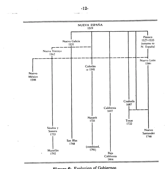
Figure 6: Evolution of Gobiernos on the North Frontier 12
Figure 2-1: Map of Nuevo Santander 40
Figure 2-2: Plan Of Nuevo Santander Redrawn from 1792 Plan 50
Figure 2-3: Plan Of Nuevo Santander 1786 51
Figure 2-4: Ciudad Victoria Tamaulipas 52
Figure 2-5: Villa de Santa Maria de Aguayo; Original Plan 53
Figure 2-6: San Fernando Tamaulipas 54
Figure 2-7: Villa de San Fernando; Original Plan 55
Figure 2-8: Reynosa Diaz 56
Figure 2-9: Reynosa. Map for the relocation of the Villa, 1801 56
Figure 2-10: Santander Jimenez Tamaulipa 57
Figure 2-11: Villa Capital de Santander; Original Plan 58
Figure 3-1: Aggregated Household size 79
Figure 3-2: Guemez: Household Population and Size Status Structure 81 Figure 3-3: Aguayo: Population Status Structure and Household Size 83 Figure 3-4: Hoyos: Population Status Structure and Household Size 85 Figure 3-5: Aggregated Pyramid: Guemez, Aguayo and Hoyos 87
Figure 3-6: Guemez Children's Age Pyramid 88
Figure 3-7: Aguayo Children's Age Pyramid 89
Figure 3-8: Hoyos Children's Age Pyramid 90
Figure 4-1: Population of the North Frontier 100
List of Tables
Table 2-I: Table Of Colonization Expenses Table 2-II: Histogram of Colonization Expenses
Table 2-III: Graph -- Distribution of Colonization Expenses Table 2-IV: Percentage Distribution of Colonization Expenses Table 2-V: Frequency Distribution of Village Foundations Table 3-I: Aggregated Population Status Structure
Table 3-II: Guemez: Demographical Statistics Table 3-III: Aguayo: Demographical Statistics Table 3-IV: Hoyos: Demographical Statistics
?J
TEXASS
-D IOI ON ccl
Die L4 \
or,
Co~C
j t.
~C 0 LONV
ijs
V' . .4t
R m do C..) · o~
JURI S-
..
~...3DI )I 0 0i _ · u
F
D EL _*
DEL
NUEVoREY
(\J
c~B 6"".NUEVO
(·.rd
ft
L·5~
7 rRidA·t 0 ,,m~~ Slf A N-9 Q.c s - Sa..u.d'r 2'gi
~~..k
TAN'Ln~
JUIDCO URIS 4 DI 0' 6~9- __ ~ R A.~A i DE L .··UIDICION ~1U·i L, I O I £:VL . .1, A v TdCAC I72 27 L..¶a,. 277 .. I-A. 3,·. 64
IDICION
DEN
~B IO~T" , b" s.A
of
ETMP rL~,O
n,-~n, 7·V~c.
· ; 6 0
6,~.:;T O - ~L · ~ r-old/
p~r~~~r~r,. g. oT~g3
JUI SDICIONLli~rurm
un·~~rl**i~lrULu~rnr·· . ON 0- ~,,
·,~rd~ tS.* Ml~icno~,~d~ I·P DLSIRA
R~
c.Cr;,-1,5
Tim~--PZ ,MC~·.~i·
SAN
~LI~c···lrI~tr'
~ 4.1UR IS
~ D1-.'
.4....L~~l6 6'.r
LR~*·, *I~·~. S1.C .
Lll ~2L rDE
1 i)R' ~~ rIJ.~·~r~~· Ta hid.(·T~·· ;~~1I2( ,,(lS.L~yL~rjGLL L S JUR I SMCI.MGcu.)·L~o hl~rr
... . AM DE LA SIERRA GORDA,
d..Q. EE. DIE 1hy. W· l.
5, CLu IId,1.s- Cr l ~f wAIc;((
"''~·~ IIIJ~~rd··d~ l.
· r711 I·R~. · ·. n URISDIC011 DE .. M.( .~ Ml... jr L.
c lJ s V, 6 t·.Lpc, ;U.M.A v~l~~··~rl
I~~
~L(L:j
~ ZQMAPAN.atciW
f-71127j
lftlu 127rrFigure 3: Extent of Spanish Control in 1600
Figure 4: Extent of Spanish Control in 1700 Before the Colonization of Nuevo Santander (Gaonel Mexico 0
----I
In4,,uo0Q rV El Paso Nacogdoches 3 S30-Dl[urango S L.US PolOSI .-Guadalalara
Extent of Spanish Control in 1800 After the Colonization of Nuevo Santander. Figure 5: I 1 L .. . ~·
i
NUEVA ESPANA 1519 Nueva Galicia 1531 Sinaloa v Sonora 1733 San Bias 1768 Mazatliin 1792
Figure 6: Evolution of Gobiernos on the North Frontier
SETTLEMENT OF THE NORTHERN PROVINCES OF NUEVA ESPAi~A. The region of Nuevo Santander at the extreme right of the diagram.
Pinuco, one of the southernmost cities in the geographical area was settled and its government established during 1527-1533.
The territory of Nuevo Leon, located west to the area of Nuevo Santander was colonized also in the sixteenth century. Nuevo Santander colonized
in the mid eighteenth century shows that for two hundred and twenty
five years it remained uncolonized.
1527-1533 (returns to Nt MW 15 California 1697 Texas 1722 Nuevo Santander 1748 (combined, 1791) Baja California 1804 1 I
Chapter 1
Introduction
What were the reasons to establish a city in eighteenth century Mexico? By whom? Could anybody do it? Why were twenty three cities established in Northeastern Mexico in five years? Was there a common plan for their foundation? If so, what was the legal code regulating these foundations? Was there a Governmental Policy for Settlements? Does this example follow the same pattern of foundation of the rest of territorial appropriation of the Spanish Crown? If different, How and Why? Did the Settlers come from Spain as in earlier colonizations of Mexico? I have looked at these and some more questions in the process of this work.
The intention of this thesis is to investigate the planning process for settlement of new territories, as put into effect by Spain in America. As a departure point I assumed that the procedures and laws, as well as the priorities of the Spanish Crown in America remained virtually unchanged throughout the colonial period. I also hypothesized that all and every action of the Conquistadores had to be backed by a legal code which would support if not encourage their endeavors. In the same manner, I presumed that even in the eighteenth century the Planning for Colonization was done by the appointed Governors, following the original operational model of the sixteenth century. I also supposed that the 1573 Ordinances of Discovery and Population, the 1680 Recopilacion de las Leyes destos Reynos de las Indias, in conjunction with the documents about the Colonization of Nuevo Santander, and some other government documents of Nuevo Leon would provide the needed pieces to put together an overview of the whole planning process.
I proceeded as follows: I examined the foundation of twenty-three towns in Nuevo Santander during the mid-eighteenth century as the main case examined to answer them. Nuevo Santander is the northeastern territory of Mexico, now called State of Tamaulipas. The north part of this territory forms the eastern international borderline with Texas USA. I also reviewed the earlier colonization of Nuevo Leon (1580). It is presented as partial frame of reference for comparison and contrast of the planning procedures and preparations for settlement implementation as followed in Spain by the Governors assigned to colonize a territory in New Spain.
The analysis of the eighteen century Policy is based on the examination of official documents prepared by the Viceregal Government for the colonization of Nuevo Santander and Nuevo Leon. In both cases I have made a correlational link with the Ordinances for Discovery and Population issued by Felipe II in 1573, and with the 1680 Recopilacion de las Leyes de las Indias. The latter document has been a key instrument for the analysis of the foundation of cities in Nuevo Santander and for the proper understanding of the early colonization of Nuevo Leon. I found that the Recopilacion is a document of enormous importance to analyze and understand the social, political, and economic structure of Latin America in general. It also became apparent that the 1680 Recopilacion not been fully explored in previous settlement analyses.
Contrary to one of the original assumptions, I concluded that the Colonization of Nuevo Santander was a government effort. It was planned, implemented and revised by the viceregal government. Families were transported from other provinces of Mexico into this northeastern region to settle the new villages. A higher number of towns were founded than in previous settlement commitments. A deadline was also fixed to achieve the foundation of the new towns. These combined factors confer unique characteristics to this foundational effort.
Something totally different happened in earlier settlement projects. For instance, in the case of Nuevo Leon, planning was done by the Governor to be. He also recruited 100 settlers in Spain to establish a only three towns. Also the rhythm of colonization of the Sixteenth and Seventeenth Centuries was much slower than that of the Eighteenth Century.
1.1 Organization Of The Material
I have divided the work according to the actors involved in the process of colonization: Government, Settlers or Population, Native Population, and Missionaries. The parallel example of Nuevo Leon Colonization will be in an appendix.
In the Government section I analyze the reasons and needs existing for the colonization of Nuevo Santander. The Planning Stages as prepared by the Viceregal Officials are also examined, as well as four projects for colonization of the territory. It contains observations about the implementation of the selected project. Layout issues of the new villages constitute the last part of the Government section. In the second part, named Population, I try to determine the level of welfare of the new towns at the time of the viceregal inspection conducted in 1757. I have constructed several demographic indicators for this purpose. This part as well as the Government one are supposed to be the core of this work. Both include appropriate observations of the laws of Indies pertaining the issues treated and the presentation of the laws themselves The correlation between actual facts and the Laws or the absence of any link between facts and laws has also been indicated.
The third part, Native Population, shows the counterpart of the colonization. For the native Indians of Nuevo Santander the colonization meant the
depopulation and eventual extinction. These issues as well as the Laws dealing with the indians are presented.
The fourth part, Missions, explore the relationship existing between the Colonizer Escandon and the friars in charge of the colonization. The power struggle of the Orders and the Government in matters of control of the Indians is presented concerning the specific example of Nuevo Santander. The failure of the Missionary activity in the new territory, its causes and effects are also discussed. The missionaries were responsible for the fall of Governor Jose Escandon, the man who conducted the colonization of the territory. I found that the missionaries had a diminished power as compared with the earlier colonizations. It also became apparent that they did not realize it.
In Appendix A, I present an overall view of the 1580 Colonization Of Nuevo Leon as performed by Luis de Carvajal y de la Cueva and a group of Portuguese Sephardic families. I also include the preliminary procedures followed by Carvajal for the Colonization. I also incorporate a copy of the Governor's Oath,
as well some other laws appertaining to this issue. This appendix also contains the Act Of Foundation Of Monterrey, the main town first founded by Carvajal and later repopulated by Diego de Montemayor the second governor of the Province.
Appendix B deals with the side-effect of the establishment of villages in Nuevo Santander: Indian mistreatment and extinction of the natives.
1.2 Conditions Prior To The Colonization
Why did the Nuevo Santander region remain uncolonized two hundred and twenty five years after the Spaniards landed into Mexico? These are some of the explanations:
1. The slow paced structure of colonization previously employed by Spain concentrated the colonization efforts in the central territory of Mexico.
2. The intricate migratory system enforced by the Crown controlled the passage of a limited number of people to the New Continent. Immigrants to the new colonies were very few and only those authorized by the Crown, thus the number of possible settlers was reduced.
3. The native population of America had deceased by the millions during the XVI Century in one of the worst biological tragedies caused by European germs brought by the colonizers. The number of allied natives which could be resettled through the formation of indian towns had been diminished during the sixteenth century, and those left in the area, were nomadic and resisting settlement.
4. "A hostile environment and the lack of precious metals in the country insured that the Northeast frontier of New Spain would remain relatively static for ... two centuries..." (Gerhard, 1982). It was however an excellent habitat for undominated natives. The latter also deterred the colonization of the territory.
On the other hand, what were the motives for the sudden colonization of the whole territory during the eighteenth century? Powerful incentives promoted the rapid colonization of Nuevo Santander.
1.2.1 Motives For Colonization Of Nuevo Santander
The reasons for the colonization of the Nuevo Santander were strategic and defensive. Territorial integration was also an important factor.
1.2.1.1 Strategic-Defensive Reasons For Colonization
The region was an attractive territory for expansion of foreign nations. France had settlers in Louisiana. Robert Cavalier de la Salle and Saint Dennis are two of the well known French aventureros who reached the present territory of Texas and Nuevo Santander. The English Colonies were also expanding and threatened the northern Spanish Territories, specially those in the Atlantic coast. With a shore line extending from the mid Gulf of Mexico to Texas, Nuevo Santander was also exposed to illegal pirate commerce. Royal Cedulas at the end of the seventeenth century attest the Crown uneasiness about this fact. Due to the presence of the French, the Spanish Viceroyalty of Mexico had started the colonization of Texas in 1716. Texan missions such as El Alamo and the town of San Antonio de Bexar (Texas), had been established to prevent foreign settlements of French and English in the area.
At the time Nuevo Santander territory was "...the most immediate, more exposed to foreign Colonies, [having in its periphery only]...the towns of Xalapa, Tampico, Panuco, Valles [to the south], and the Presidio de los Adays [TX], to the north]..." (Velazquez4, 1979, 37). The territory was an empty, uncolonized land in the Northeast of Mexico, almost inaccessible due to the presence of belligerent natives.
It was an Indian territory with no Spaniard inhabitants but surrounded by a few Spanish towns. In general the northern region had been for the both Governments, Mexico and Spain "...a minor financial and administrative burden
and a late sporadic strategic worry, if also a potential growth [area] for a distant future..." (Altman, 1976, 197).
1.2.1.2 Colonization As A Need For Regional Territorial Integration
The zone had been an Indian Frontier until its colonization during the mid eighteenth century. The royal Cedula of Carlos II dated May 14 1686 acknowledges the presence of Indians and related problems in the Province of Nuevo Leon, adjacent to the west of Nuevo Santander, as well as along Mexico's Gulf coast from Florida to Campeche and Guatemala. (Muro-Orejon, 1956, LXVI)
1.2.1.3 Communication Needs As Colonizing Incentive
Another reason to promote the colonization of this region was the excessive round-about way needed to communicate the Capital of Mexico with Texas. The shortest distance in-between crossed the dangerous Indian region of Nuevo Santander. Texas was one of the distant regions with which the Viceroyalty needed to communicate.
1.2.1.4 Other Motives For The Nuevo Santander Colonization
The need to colonize the empty lands of the North Mexico was clearly a priority of the Bourbon administration during the eighteenth century. I observed that the need for immediate territorial occupation resulted in the implementation of a different mode of colonization based on a more dynamic rhythm and intensity in the establishment of new towns. Settlers form other provinces were motivated to participate in the formation of new villages. During the Bourbon Crown Government internal colonization cases seem to dominate over settlements done with immigrants from Spain. For example the eighteenth century Chilean settlements and those established in Colombia by Mon y Velarde at the end of the same century, follow a similar pattern. In Mexico, other northern regions such as north Nueva Vizcaya were populated simultaneously to that of Nuevo Santander.
1.3 Spanish Institutions Of Colonization
Three primary agencies intervened in the Spaniard "pacification" model, 1. The Conquistador representing the Government,
2. The Church dealing with the Indians, and
3. The Soldiers.
In early colonial times, sixteenth and seventeenth centuries, the Conquistador was to recruit settlers from any of the Castillian kingdoms, and put together cattle, ammunitions, staples, clear the migratory regulations for the settlers, in order to sail to the new lands and settle the previously agreed territorial tract. The Conquistador had to take oath at the Casa de Contratacion, deposit a "fianza," a monetary deposit, and conduct the colonization at his own expense, to be later compensated with the new richness to be exploited, and with the nobility granted to him by the Crown for his services. Both the words, Conquista, and Conquistador, were deleted in the law in early colonial times and substituted by the word "Pacificacion, and Capitan". (An example of this system can be seen in Appendix A which deals with the Colonization of Nuevo Leon).
1.3.1 Actors In The New Frontier
In Nuevo Santander the same three colonizing institutions were present: the Spanish Capitan, named Jose de Escandon, the Franciscan Friars of Zacatecas, and the soldiers. The settlers in this particular case came not from Spain but from the nearby Mexican provinces of Queretaro, Nuevo Reino de Leon, San Luis Potosi, and Coahuila. These were the new frontier actors: Government, Soldiers, Friars, Settlers and indigenous population.
1.3.2 Two Styles Of Government: Hapsburg And Bourbon
The control of the Spanish Crown by the Hapsburg House ends with the seventeenth century. The eighteenth century starts with the Bourbon Crown in Spain. The changes originated by the new Royal Government led to a new style of Government and colonization.
1.3.2.1 Hapsburg And Bourbon Colonization Patterns
Some of the differences of the operational modes of colonization of the Hapsburg and the Bourbon Houses are illustrated in the following table. The legislation about the Indies was a work of the Hapsburgs. Felipe II 1573 Ordinances, and the 1680 Recopilacion are issued before the Bourbon era.
Hapsburg Model XVI-XVII Centuries Bourbon Model XVIII Century 1. Discovery and colonization at the expense of the colonizer. 2. Agreement for the new
colonization done with the king. Casa de
Contratacion. 3. Recruitment of 100
families from the
kingdoms of Castilla and
Aragon.
4. Compromise to found two to three cities in less than four years
5. Land and Indian labor granted to the new Governor and settlers. 6. Promise of Nobility Title
as compensation for a good performance of the new Governor.
7. Rights of the new Governor to assemble a Mayorazgo. (Entailed
estate).
8. Right to the new Governor to appoint Justices, and majors.
Right to inherit Governorship to son.
1. Same
2. Usually with the Viceroys 3. Settlers were usually
taken from adjacent provinces. Planned number of families agreed by both the government and the new governor. 4. Planning for higher
number of towns done by government and the appointed governor. 5. Land grants, no Indian
labor granted. 6. Same
7. Same 8. Same
new priorities of government, to expel the Jesuits of Spain and the colonies, and to face the Independence wars of their American dominions. These were the preconditions existing before the colonization of Nuevo Santander, as well as the implicit and explicit needs for the immediate control of the empty territory.
Economic priorities caused by recurrent European wars demanded a more intense exploitation of the colonies. The basis for richness was extractive not productive. A larger area under control meant a higher possibilities for extraction. More intense extraction meant more richness. To the huge needs, the adequate solution was the more intense exploitation. The needs of territorial occupation required a higher and more intensive number of settlements and cities: timing was essential.
Chapter 2
The Government
2.1 New Policies for Colonization
A new settlement policy is practiced by the Bourbon dynasty in the eighteenth century: Intensive occupation of empty territories in the colonies. Territorial appropriation is achieved through government planned-financed colonizations. Such was the case of Nuevo Santander. New economic and defensive priorities superseded previous priorities of religious conversion.
The key institution for colonization was the Government. Thirteen villages were founded in the first two years of settlement in Nuevo Santander 1748-49. A total of twenty-three were to be completed by the end of 1755. The rate of foundations in the eighteenth century is not only more intense but there is a change in the Settlement Policies and priorities of the Government. The new preeminences
are expressed by Escandon, the colonizer of Nuevo Santander, in a communique to the central government.
"...In the new colony [of Nuevo Santander], the rules prescribed by the Laws [of the Indies] for the new conversion of the Indians must not be followed because this settlement has been formed by cities and Villages of Spaniards, and the Indians have to be reputed as aggregated and subordinated to the Justice representatives in them...." (Archivo1, 1929,Vol.1,197)
However in matters of public image, the Crown still kept alive the idea of Christian conversions as the main motive for colonization. The friars did not
realize their diminished power which was made evident after a missional failure due to lack of governmental support.
In the mid eighteenth century the Viceroys were able to commission new discoveries. Law III, III, 28 of Indies declares:
"We grant faculty to the Viceroys for when even being prohibited to grant new discoveries, pacifications, and populations [settlements], they may do it if necessary in the purpose of the peace, calmness or pacification. We allow them to appoint, the persons... more suited for the purpose. We mandate the Viceroys and Oidores to extend them the necessary titles and instructions, for being the main motives the [territorial] expansion, [and] the instruction of the doctrine of our Holy Catholic Faith; be the naturals well treated."
There were two main objectives to be reached: (1) The appropriation of the uncontrolled territory by the creation of settlements of 'colonos', and (2) The clustering the nomadic natives in missions concentrations. Indian Missions were units of control of Indians. The territorial occupation goal was to be successfully achieved. New towns of Spaniards were established. On the other hand, the missional activity failed. Indian settlements at mission sites did not succeed. The natives were to be ultimately exterminated in a struggle of more than seventy years of fight and hostility. (Zorrilla, 1976, 8)
2.2 Planning Stages Of Colonization
I will proceed to the revision the process of colonization as planned and executed by the Viceregal government in 1748. First it is necessary to analyze the causes that generated the change of policy in the new Government.
The war of succession culminated with the ascension to the Spanish Crown of Felipe V. It was the end of the Hapsburg dynasty, but also a new Bourbon era for Spain and its colonies. As a consequence of this change, the bureaucracy transmuted from aristocracy to a new technocracy. A new meritocratic system operated as a general principle. Government posts were to be occupied by technicians rather than by aristocrats. Spain was in war. It had a huge continent with uncolonized areas. The choice for the government was either to become more efficient, or be doomed to loose the new territories to other countries. This need to control and secure more territory with minimum expenses brought as a result a more efficient government and the appearance of a change in priorities and policies. Colonization was to be more intensive both in time and in extension. This is reflected in the policy-making documents prepared for the Mexican Viceroy by the Marques de Altamira, regarding the colonization of the Sierra Gorda or South Nuevo Santander. The documents provide a precise account of how the planning stages for the colonization of the new territory were to be conducted. Juan Rodriguez de Albuerne, Marques of Altamira, was to typify this new high-ranking generation of well informed, ad-hoc trained, independent and powerful Viceregal bureaucrats. He planned the colonization of the new region. Later, the government was to order an Inspection of it, a feedback mechanism.
2.2.1 Reconnaissance Of The Territory
The steps for colonization included preliminary exploration followed by the settlement process. The explorer of the territory was to be preferred for the governership of the settlement under the condition of his previous good services.
The following government report was prepared for the Viceroy concerning the planning stages of the colonization of Nuevo Santander. These are the instructions of Rodriguez de Albuerne, Minister of War, to survey the territory in three sectors:
"...One from south to north, [from the Panuco River] to the mouth of the Rio Grande river (also called Rio Bravo), another from the Bahia del Espiritu Santo [Matagorda Bay, TX USA], to the same mouth of the river [Rio Grande], in such a way that those in charge of the reconnaissance be able to meet at once in one and the other riversides at its mouth in the Seno Mexicano [Gulf of Mexico]. Both reconnaissances will need sufficient people to register and examine accurately the traveled terrain in its entire width, from the coast of the said Seno Mexicano [Gulf of Mexico] to the already pacified and populated [western lands of Nuevo Leon], stating the existing distances, plains, valleys, canyons, mountains, rivers, streams, [drinking] water sources, sites for settlements [pueblos], farmlands, pasture, number of barbaric Indians, their families, their nations, and any other important issues...To don Joaquin de Orobio, capitan of the said Bay [Espiritu Santo, see map p. 51], it could be delegated the reconnaissance of the territory beginning there at the Bahia [and moving southward] to the aforesaid mouth of the Rio Bravo river, ordering also to the [Spanish] governor of Texas that from his Presidio [garrison post, named] 'de los Adays,' to send twenty five 'presidiales' to accompany don Joaquin [de Orobio], with some other twenty [soldiers] from said Presidio of the Bahia so that he [Jose de Orobio] may go back. Be also ordered to Don Pedro de Rabago Teran Governor of Coahuila [Mexico] to assign an experienced individual he trusts upon, who with twenty five soldiers from [the Presidio] San Francisco de Coahuila, with the largest available amount of residents [vecinos] he may recruit, ...[together with] the new soldiers destined to the missions of San Antonio de Bexar [TEXAS] to do a similar reconnaissance of the settled and pacified areas within that Province of Coahui la, along the Sabinas River, entering later to the said Rio Grande,
following to where the Nueces Rivers mingles in, and meeting in that site, the Captain from the Bahia [and his soldiers], so that together [the troops] proceed to the said Rio Bravo river mouth. A third expedition shall be delegated to the Teniente de Capitan General [Jose de] Escandon, beginning from the [southernmost part of the] said Sierra Gorda [Eastern Sierra Madre], Villa de Valles [TAMS], and seaports of Panuco and Tampico [TAMS] to the same Rio Grande del Norte or Bravo mouth rendezvous site, where he shall meet the Captain of the Bahia, having according previously about their respective departure and meeting dates. [What follows are the most revealing data of the document...] Since it is ordered by the Laws of the Indies 1, 4, 6, and 8 Title IV,Book IV that by soft means attain the friendship of the naturals, [this is an almost direct copy of the law] giving them some things of their preference, without craving for theirs or taking them without payment, and thus establishing friendship with the principal Indians that be of importance for their pacification. And if being enough for the pacification the religious friars, no other person who may be obtrusive shall enter, [this is also a direct copy of the Laws of Indies], and that in the new discoveries, the word 'conquista' be not mentioned and 'pacificacion' and 'poblacion' [settlement] be used instead [ this is one of the first Laws of Indies]. Consequently, the said Teniente de Capitan Escandon and the Captain from the Bay, shall be prevented, to make it public by 'bando' [edict] to their people [about the treat ment to the Indians, the transgressors were to] be punished with the penalty of life...The Governor of Coahuila and the Captain of the Bay, do order to all the governors, Alcaldes Mayores (city Majors), Justicias, [Justice representatives], Military Officers, Corporals [Cabos -- usually the second in command of a town], and military Soldiers, and to any other persons, under the most grave punishment, not to impede by any
means such reconnaissances, or any other of the related proceedings, but on the contrary to provide all the help and favor, which will be taken into account for its fair and proper compensation...and do communicate [it also] to the Marques del Castillo de Aiza [land holder of huge extensions of pasture land within Nuevo Santander], so that his people may help, since his lands will be crossed [by the expeditionaries]...." (Velazquez2,
1976, 62)
This was the plan of the Auditor de Guerra, Marques de Altamira for the colonization of the Nuevo Santander. The text above establishes a firm evidence that colonization of the new territory was planned by Government. The fact becomes even more explicit by the presence of four projects presented to the authorities for the colonization of the land.
2.3 Projects For Colonization
According to the preceding document, in 1746 Jose de Escandon had already been commissioned to implement the future settlement. There were four projects for the colonization of the same territory including the one by Escandon.
1. One was presented by the Governor of the adjacent Nuevo Reino de Leon, Jose Fernandez de Jauregui.
2. A second one by Narciso Barquin de Montecuesta, former Alcalde Mayor (city Major) of the Villa de Valles -- one of the towns at the southern end of the new territory.
Nuevo Leon, writer of a book about that province. He traveled to Madrid to defend his proposal.
4. The fourth project was presented by Jose de Escandon. Escandon's proposal was the one selected.
There had been at least two previous independent expeditions into the territory before the projects were presented. Ladron de Guevara conducted one of the excursions. He presented his proposal in Spain, and obtained Royal recommendation for the task.
The presentation of several projects generated a order by the King for the creation of a Commission formed by the Viceroy of the New Spain, some Oidores of the Viceregal Council, and the other officials to select "...the person judged to be the most suited for the [official] expedition, providing him with the necessary assistance...." (Zorrilla, 1976,25). The Royal Cedula also recommended the project of Ladron de Guevara.
The following analysis of the selection process aims to find out if the basis for the decisional strategy employed to determine that Escandon's project was the best suited. We know that Guevara's project had the royal recommendation, but it is also known that he had one bad point against him. He favored the 'congregation' --a loc--al euphemism me--aning sl--avery -- of the Indians.
Why one might ask, was the project of Escandon selected? There have been suggestions that it happened as a result of his personal contacts in the Viceregal administration. The following paragraphs attempt to find out the true rationale behind the selection by examining the section dynamics testing them vis-a-vis with the legal prescriptions of the Laws of Indies. Both the appointment of Escandon and the selection of the project shall be clarified.
2.3.1 Analysis Of Project Selection Procedures
A change of Viceroy took place when the project selection was being discussed. One has to remember the rotational characteristics of the high Spanish Bureaucracy. Although the following Viceroy was new, the new Bourbon bureaucrats provided the much needed continuity. The Marques of Altamira was informed about the issues. His judgement seems to be key factor in the final assignment of the colonization project. I have assumed that his decisions should have been supported in the law, but the analysis will provide a definite judgment.
The revision of the Laws of Indies provides a basic insight of the elements for decision-making very likely employed by Marques de Altamira. On the Chapter dealing with Discoverers Pacificators, and Settlers, Law number 4 of Book IV Title VI, proclaims:
"Do favor the discoverers pacificators and settlers and persons who have been in our service.... Favor the first discoverers of the Indies and other persons who would have served and worked in the discovery, pacification and population, by employing them and giving them preference in the matters of our Royal Service, so that they may serve us, and be placed according to the quality of their persons wherever necessary...."
The authors of the four projects were all in the Royal Service, but Guevara already had the Royal recommendation. The analysis of Escandon's project should be considered against the recommended project to determine why this was not the implemented one.
Escandon had participated the previous decade in the pacification and re-population of some abandoned Mission sites in the south part of the Sierra Gorda
[Eastern Sierra Madre in the 1740's]. This is shown in his Relation of Merits, later submitted for the granting of the Nobiliary title of Count:
"...1728: Founds a settlement of fifty families in the Sierra Gorda. 1734: Pacifies rebellion of more than 10,000 Indians in the village of San Miguel el Grande [San Miguel de Allende QRO]
1740: Appointed Coronel of the Regiment (being previously Sergeant Major).
1741: Appointed Teniente de Capitan General of the Sierra Gorda and its Frontiers [Nuevo Santander]. Since 1740 conducts four 'entradas' [incursions] for pacification and repopulation..." (Archivol, 1929,vol.1, 303).
Marques of Altamira in his communication of Aug 27 1746 also notifies the Viceroy about Escandon's previous activities:
"...by then the Coronel of the Regiment of Queretaro [city] and Teniente de Capitan General of the Sierra Gorda had managed the total pacification of the territory [southern part of Nuevo Santander near the City of Queretaro where Escandon was stationed at the time], having done it at his own expense, without any expenses of the Royal Exchequer whatsoever..." (Velazquez2, 1976, 59).
By Law, all discoveries were conducted at the expense of individuals and never of the Royal Crown.
Another document found in the Archivo General de La Nacion in Mexico City provides a later account of the activities of Escandon in the Sierra Gorda and of the decisions taken by the Auditor Marques de Altamira, "...Because in four general incursions to the Sierra Gorda conducted at his own expense and without any
expense of the Royal Exchequer [Real Hacienda], the Theniente (sic) de Capitan General of it, Coronel of the Military Regiment of the City of Queretaro, Don Jose de
Escandon...had visited the twenty six missions of the Sierra Gorda and Custodia of
the Rio Verde river, founding and renaming eight of them, bettering and augmenting them...." (Velazquez2, 1976, 36-37)
Escandon seemed to be an experienced man in pacification matters, having performed the pacification of the Sierra Gorda. Ladron de Guevara, who usually showed himself accompanied by Indians in Nuevo Leon, had prepared his book about the towns of Nuevo Leon to demonstrate his qualifications and knowledge of Pacification issues. Fernandez and Barquin did not seem to have had special personal experience in pacification issues, although Fernandez also wrote a book about the Nuevo Reyno de Leon. This province still experienced Indian problems, which obviously neither one of them had been able to solve.
The final decision for the selection of the Project came
"...On September 3, 1748, [when] the Viceroy Francisco de Guemes y Horcasitas Conde de Revillagigedo, appointed Don Jose de Escandon: Teniente del Virrey in the Coast of the Seno Mexicano, [The Viceroy's Lieutenant in the Gulf of Mexico's coast] ... rejecting Don Antonio Ladron de Guevara for the task in consideration of his being a person of doubtful honesty, being notorious for his scandals [promiscuity] among the Indian [women] of that frontier... and because honest persons of that frontier, assure that he is linked to Hacendados [Hacienda land-owners] to establish in that [new] colony the congregas...." (Montemayor, 1979,
intro)
The 'congregas', concentration of Indians, were the opprobrious form of slavery instituted in the neighbor kingdom of Nuevo Leon, by the first Governor and
settlers, causing great upheaval and decimation among the native population. Indian slavery had been abolished several times.
It is apparent that the Crown was not willing to face this old problem anymore. In the past, the forbidden Indian slavery first practiced locally in the 1580's, had contributed to the failure of two colonizations: Nuevo Reino de Leon and Nueva Vizcaya. The Indian insurrection and attacks to the new Spanish settlements had caused their eventual depopulation, with the consequent lack of land holding for the Viceregal authorities. In those times of urgent defensive priorities and extreme territorial control needs, the Viceregal authorities were not willing to risk the colonization of Nuevo Santander by the replication of old problems. Although Guevara's project was rejected, he served in the settlement implementation under the watchful eye of Escandon. When the actual settlement expeditions took place, Guevara was in charge of the group of families who having resided in Nuevo Leon, were to become first settlers of some of Nuevo Santander's villages.
The Laws of Indies and Escandon's previous record of Pacification of the Sierra Gorda were the key factors for his appointment. Nevertheless what is more relevant at this point, has been to observe how the technical efficiency-oriented Bourbon government operated. From the examples above, it seems that the old aristocratic decision-making process was a thing of the past. The new technocracy was in charge and working.
2.4 Implementation Of Settlement
The actual implementation expeditions were carried out as previously planned. The groups of settlers and soldiers were formed and departed for the new villages and to the rendezvous point. The newly appointed
"...Viceroy Revillagigedo, ordered the Governor of Nuevo Leon, to give the necessary assistance to his Teniente [Escandon. The Nuevo Leon group of settlers and soldiers, was commanded by Don Antonio Ladron de Guevara] having departed from San Felipe de Linares on January 28 1749, with 23 soldiers and the military squadron of the San Pedro Boca de Leones Presidio, seventy families [of settlers], and five Indian guides." (Montemayor, 1979, XXI).
(One must realize that roads of any sort into the new territory were completely non-existent).
"...[Early] in the month of December [1748] Escandon [had] departed from Queretaro with 750 soldiers and presidiales, a huge number of Spanish 'vecinos' and Christian Indians, which with women and children made altogether more than 2,500 [persons]...." (Zorrilla, 1976, 26).
"On February 2 [1749, Guevara's]...Indian guides made the first contact with the expedition commanded by Escandon. Once together, they continued the inspection of the region, having been attacked by the belligerent natives who were always repelled.... [On February 17, 1749, they founded the Villa de los Cinco Senores [Santander Ximenez, TAMS]. Later on Don Antonio [Ladron de Guevara], and Don Jose [de Escandon having left the families they carried in a camp], departed northward with fifty soldiers, arriving to the
[Rio Grande del] Norte river on February 24 [1749], and camped on the south riverside [present Mexican border river side, on a site] 22 leagues [60 mi-100km. west] of the Gulf coast. In this place they [awaited to meet] the expedition coming from the Gulf [Bahia del Espiritu Santo, Texas]...." (Montemayor, 1979, XXI)
Escandon had founded the first town two months before he reached the rendezvous point. He had founded Villa de Llera on December 24, 1748. Twelve new villages were founded under his orders during the first twelve months of settlement campaign. Escandon was supposed to establish two additional villages in the present territory of Texas. Bedoya and Santa Dorotea were never founded. On June 13 1749, in the middle of intensive settlement work, Escandon sent a report to the Viceroy from Queretaro.
"...Of [the village] Santa Dorotea [to be located in the vicinity of the Presidio de los Adays, in what is now Texas], I have no news, and I do not expect them until it rains, since the prevailing drought is so severe that even drinking water cannot be found along the pathways, or even men who are willing to travel. However I have no doubt that Captain Basterra, is already 'in situ,' at the Presidio and Mission del Espiritu Santo Bay, as ordered to him. The Villa de Bedoya in the Nueces River [Texas], was among the last to be recruited [for settlers], but he [the assigned captain also] gathered 'his fifty families of pobladores' and the squadron of soldiers among the best of those who were willing to go; The scarcity of maize and the pandemic [epizootic] of the horses generated by the lack of grass are [the reasons because of which] he had to delay his journey. But, he has communicated me that he did the journey and I suppose he should have been there by May 15 [1749]. Signed, Jose de Escandon. Queretaro and June 13 1749." (Archivo2, 1931, Volume 2, 290-291)
SOMC 50 0 SAN * VILLAGE S MSSION / VILL, VOUS POINT LUARY 1747 o MISSION / PRESIDIO .. , \S . -RANCH PALMILLAS-, SCHARCAS I TuLA
-RA" • - i-. ESCANdON
LLERA
oGADALCAZAR" OR CASITAS 'I •
SANTA 8AARA46 . AL TAMIRA
O1 TAMFco
* SAN LUIS POTOS ...-.
'II
0
4-Q•UERETARO
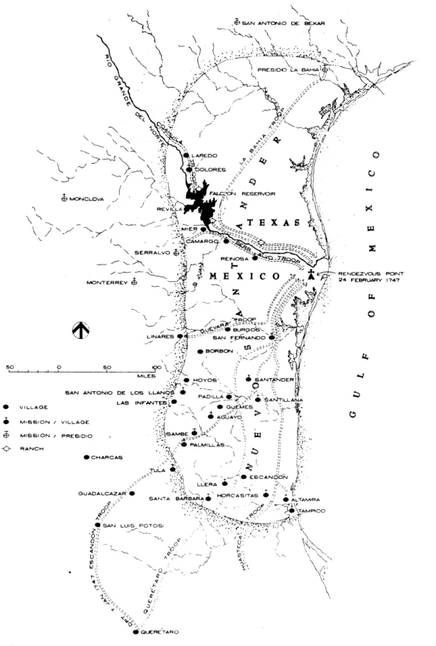
Figure 2-1: Map of Nuevo Santander Redrawn from 1792 Plan
Settlement Expeditions.
2'
0 p:·qEscandon established more towns than those originally planned by him and the Viceregal government. Several scattered ranches that existed along the Rio Grande del Norte, and other unorganized settlements located at the foothills of the Eastern Sierra Madre in the vicinity of Tula, were formalized by Escandon without any expense at all from the Royal Exchequer. The already low unitary cost achieved by Escandon for the establishment of a town was reduced even more. It seems that the momentum generated by the initial settlement of towns, spread the news rapidly among the ranchers scattered in several parts of the territory, who in different occasions met with Escandon to have their settlements recognized, legalized, and hoping to enjoy the benefits that the new settlers were entitled to: ten years free of any taxes, distribution of urban and rural land in addition to the
implicit recognition from the government for their service. Several Question Arise From the Document, Such As:
1. What was the original number of families per town, as planned and as implemented? Was there any difference? The planned number of families per town has not been clearly defined in the consulted documents. I assume that such data should exist in unexplored documents in the National Archives of Mexico or in the Indias Archive of Sevilla; further research shall provide an answer. All we know is that Guevara transported 70 families of settlers and Captain Basterra recruited 50 families for the town of Bedoya, but it is also know that the town of Laredo was founded with less than 10 families. No definite conclusions can be formulated from Escandon's declarations about the overall number of families that entered the territory.
2. Was there a pre-established unitary cost of foundation for each town to be settled? Escandon mentions having submitted a minimum number of families as needed to accomplish the settlement of the territory. These families were to receive 'ayuda de costa' or financial help to settle. This expenditure is included in the overall settlement expenses. It is known how much was spent, but since the amount of financial help given to the settlers of different towns was not the same, it is not possible to determine the number of settlers for each town this way, or the cost of founding a town. Escandon also declared that more families settled the land than was originally intended.
3. Was there a policy of economic incentives for the new settlers? There was a determined and explicit policy for the new settlers. It was first established in the 1573 Ordinances 104, 105, 106. Later these Ordinances were incorporated in the 1680 Recopilacion. In 1748 during the colonization of Nuevo Santander the same law was applicable. It is the first Law of Book IV Title XII which observes:
"To the new settlers lands shall be given, as well as urban lots, and encomiendas of Indians [distribution of forced Indian labor]....To motivate our vassals to the discovery, and settlement of the Indies, and being our desire that they can live with commodity and convenience, it is Our will that may be distributed, and be distributed house-land-lots, cava llerias lands and peonies lands, to all whom would go to
settle new lands in the Pueblos and Sites to be assigned by the Governor of the new Population. A distinction shall be made among Escuderos, infantry, and those of lesser grades and merits, according to the quality of their services so that they can take care of the cultivation of land and livestock raising. Having built their dwellings and done their cultivation and residing four years in those towns, we grant them faculty from then on, to sell them [the distributed lands] as things of their ownership, and the Governor or whoever would have our faculty, shall distribute 'encomiendas' [forced labor of Indians] in the overall repartition made..."
Indian forced labor had been already abolished. It never existed in Nuevo Santander, as a promise for the new settlers. I found in the list of settlers for the towns only one settler, coming from Nuevo Leon who declared to own one slave.
Relevant facts stated in the document above include the declaration of 50 families per town, but as previously discussed it is not constant; the presence of the soldiers is also relevant, and of scattered individual settlers in the territory specially in the plains along the Rio Grande, a well as the pattern of incentives given to the new settlers following the ideas prescribed by the Laws of Indies.
Having reviewed aspects of the planning and implementation of the colonization I will proceed to the presentation of some plans of the towns. All the villages founded by Escandon followed the grid-plaza layout.
2.5 The Towns Layout
How were the towns built? Were there preconceived town plans for the villages? Were they built following a common knowledge of how a town should be without having a previously elaborated plan?
In 1757, when the Inspection to the colony ordered by the Viceroy took place, the descriptions of the town and the declarations collected by Don Jose Tienda de Cuervo, and the engineer Don Agustin Lopez de la Camara Alta, provide one of the most interesting documents to find out the stage of construction generated in the 5 to 9 year old towns.
The Laws of Indies in this respect recommended immediate construction activities after the village foundation. "Having sown, [the land], shall the settlers commence to build" This is in Law XV of Settlement in the Laws of Indies which corresponds to Felipe II Ordinance number 132.
"After having the land sown with seeds and livestock placed in good quantity and disposition...They shall start with utmost care and laboriousness to establish and build their houses of good foundations and walls, and be provided with mud-bricks molds [tapiales], woodboards and all other convenient tools needed to build diligently and at low cost."
The inspection conducted by Cuervo and Camara Alta, describes the towns in some cases as without order and others with apparent order and good constructions around the plaza space. These indicators suggest that disorganized shacks of the earliest settlements were incrementally substituted by constructions of more permanent materials, and in a more organized layout following a preconceived plan.
2.5.1 Confusion About Town Plans
Before introducing the plans of the towns I shall address the issue of previous confusion and misunderstanding that generally has existed about old town-plans. This misinterpretation regards their representation and their contents. Do old town-plans in general represent an a-priori will of how the new village was to be built? or is it a-posteriori expression of how it was actually built?
It has been questioned if the plans for a town were actually drawn after some actual construction of the city had been already done. The inquiry stems from the fact that for some other colonizations no original plans have ever been found.
Other precarious and baseless assumptions about Spanish town's layout have been developed around the partial basis of the Ordinances of 1573. Many well intentioned and serious works studying the layouts of villages lack the needed incisiveness because of their fragmentary knowledge of the Recopilacion de Leyes de Indias, issued in 1680. The Royal Ordinances for the Layout of Towns issued by Felipe II in 1573, and the Recopilacion of 1680, are two different things. The Ordinances of Felipe II correspond to preliminary stages of colonization. The more comprehensive Recopilacion has includes not only the accumulated foundational experience, but more refined urban knowledge, and other legal ordinances are later structured and compiled in. The previous experience acquired by the Spanish institutions is reflected into the more complete 1680 compilation. The validity and use of the 1573 Ordinances ended in practice when the 1680 Recopilacion was issued. The latter remained valid until the independence of the colonies at the beginning of the nineteenth century. By assuming that the Ordinances and the Recopilacion are the same some analysis of urban layouts and of other urban related issues have arrived at erroneous conclusions. The use of obsolete or fragmentary legal information has created unnecessary confusion.
Endless sterile discussions about layout issues aimed to explain the raison d'etre of the orthogonal layout form of Spanish America settlements are generally based in a small section of the 1573 Ordinances. Urban Design issues are not the ultimate objective of the Laws of Indies, nonetheless they are implicit in the Laws. Towns however, were not laid out without any preconceived plan as some uninformed specialists have asserted. I found out that for the foundation of a town, both the 1573 Ordinances and the 1680 Recopilacion required the previous preparation of a Plan for every new town to be established. The exploratory expeditions served the purpose of site selection and preliminary layout conception. Town plans were actually carried when the settlement took place. Cities were not to be designed in situ, but in advance.
A careful analysis of the original Ordinances issued by Felipe II, could have shed some light in this issue long time ago. In the Laws of Indies, Law XI, title VII of Book IV, registers in its title " The land lots shall be distributed by sortition [i.e. drawing chances -- suertes]." The body of this Law, indicates: "Distribute the land lots by drawing chances to the settlers, continuing from those [parcels] destined for the main Plaza, and the rest do remain for Us to grant them to those who went to settle, or whatever Our will be: And We mandate to always carry, already made, the Plant [layout] of the place to be founded." (Recopilacion 1680, Libro IV, Titulo VII, Ley XI).
This was an old disposition already present in Felipe II's Ordinance 127 of 1573 which urged to carry "already made" the plant of the town to be established. A plant is the drawing of ground layout in an orthogonal view from above.
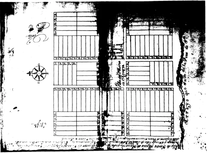
What the situation was in Nuevo Santander in this regard can be found in an inedit proceeding of the Foundation of Santa Maria de Aguayo [Ciudad Victoria, TAMS present day capital of the state]. "...the construction of the houses be
done according to the manner that his Lordship (Escandon) has indicated, and subject to the measurements of the map he left to Captain Olarazan for the purpose...." (Zorrilla, 1976, 150) In this new internal colony, the Captain, who also acted as the town's political representative, was also responsible for the building of the town, according to a previously designed plan.
Another instance can be found in the proceedings for the foundation of the town of Laredo [now Texas]. In 1755, when Thomas de Sanchez petitioned through Jose Vasquez Borrego permission to found a town to be incorporated to the Nuevo Santander. Escandon's answer was "...to start the settlement near the Nueces River... granting him license to do it in the name of His Majesty. To found the Villa of Laredo... for which ordered formation a Map (village layout plan) is being sent, as well as the title of Capitan...." (Velazquezl, 1974, 139-140)
These examples show that the layouts for the towns were prepared in advance for each site. They were used for the building of the town, and there was a person responsible for the construction of the town. This illustrates another aspect of the role of the government participation as an active planning entity in the colonization of Nuevo Santander.
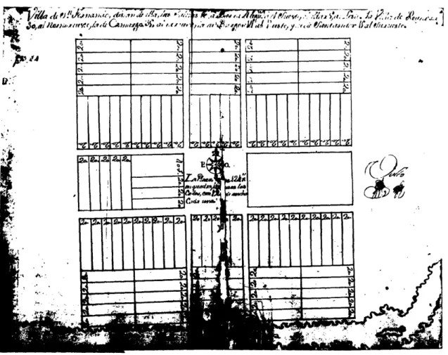
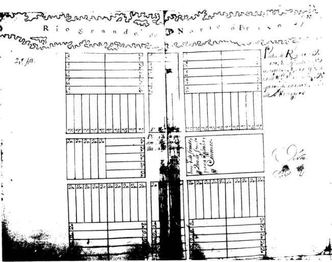
2.5.2 Selected Town Plans
Fifteen of the original plans for the Nuevo Santandar towns are preserved in the National Archives of Mexico City, with the rest of the original government documents of the colonization process. Two town-plans are found in the Indias Archive at Sevilla, while a very important and accurate large plan of the region which includes the plans of the villages is held in England, and no copies are available for study. This last document would be a key element for a more complete evaluation of the physical evolution of the two to six-year-old villages.