HAL Id: hal-01713844
https://hal-univ-paris.archives-ouvertes.fr/hal-01713844
Submitted on 19 Jun 2019
HAL is a multi-disciplinary open access
archive for the deposit and dissemination of
sci-entific research documents, whether they are
pub-lished or not. The documents may come from
teaching and research institutions in France or
abroad, or from public or private research centers.
L’archive ouverte pluridisciplinaire HAL, est
destinée au dépôt et à la diffusion de documents
scientifiques de niveau recherche, publiés ou non,
émanant des établissements d’enseignement et de
recherche français ou étrangers, des laboratoires
publics ou privés.
Spread 3: Megacities and archipelagos: an emerging
urban framework
Cathy Chatel, Jacques Imbernon, François Moriconi-Ebrard
To cite this version:
Cathy Chatel, Jacques Imbernon, François Moriconi-Ebrard. Spread 3: Megacities and archipelagos:
an emerging urban framework. A New Emerging Rural World - An Overview of Rural Change in
Africa, Second, revised and supplemented edition, 2016. �hal-01713844�
1
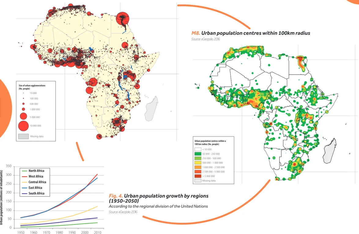
M8.
Urban population centres within 100km radius
Source: eGeopolis 2016
Fig. 4.
Urban population growth by regions
(1950-2050)
According to the regional division of the United Nations
Source: eGeopolis 2016
M7.
Population of urban agglomerations of over 10,000 inhabitants
Source: eGeopolis 2016 0 50 100 150 200 250 300 350 Urban population (millions of inhabitants) 1950 1960 1970 1980 1990 2000 2010 North Africa West Africa Central Africa East Africa South Africa Missing data
Size of urban agglomerations (No. people) 10 000 100 000 500 000 1 000 000 5 000 000 10 000 000
Urban population centres within a 100 km radius (No. people)
< 50 000 50 000 - 250 000 250 000 - 500 000 500 000 - 1 000 000 1 000 000 - 2 500 000 2 500 000 - 5 000 000 > 5 000 000 Missing data
ANEWEMERGINGRURALWORLD ANOVERVIEWOFRURALCHANGEINAFRICA 20
3
PlanchePlanche
MEGACITIES
AND
ARCHIPELAGOS
:
AN
EMERGING
URBAN
FRAMEWORK
The extraordinary urban growth that charac-terises the whole of Africa is producing dense networks of towns that constitute urban archi-pelagos. But the limitations of intermediate urbanisation, despite the emergence of small towns in rural areas, are hampering territorial development and the diversifi cation of local economies.
•
The emergence
of vast urban clusters
Huge urban clusters are developing on the African continent. In the Nile Valley in Egypt, Cairo, with a population of almost 15.7 million people in 2010, is the biggest metropolitan area on the continent. On the Mediterra-nean coast, a highly urbanised coastal strip stretches from Tripoli in Libya (1.9) to Agadir in Morocco (0.8) and includes several large cities: Algiers (3), Rabat (1.8), and Tunis (1). In West Africa, urban population density is high from the Gulf of Guinea coast to the Sahel region. Nigeria is still by far the most urbanised country, with the major cities of Lagos (10.5), Onitsha (6.3), Kano (3.1) and Ibadan (2.4). Large cities are located throughout the rest of the region: Abidjan (4.3) in Côte d’Ivoire, Accra (3.6) and Kumasi (2.2) in Ghana, Bamako in Mali (2.3) and Dakar in Senegal (2.6). In the Ethio-pian Highlands, a dense urban network has developed around the capital Addis Ababa (3). In the Great Lakes region, Kampala in Uganda (1.7) and Nairobi in Kenya (4.4) are large cities that are connected via networks of small and medium-sized towns and regional capitals re-sulting in a conurbation in western Kenya with 3.9 million people on the border with Uganda. In the northern part of South Africa and in
Cathy Chatel, Jacques Imbernon, François Moriconi-Ebrard
the extreme south of Mozambique, an urban network has developed around Johannesburg (7.2), stretching towards Bloemfontein in the interior of the country and to Durban (3) and Maputo (1.9) on the coast.
In addition to these dense urban clusters, cor-ridors of urbanisation are emerging between Lake Chad and the Ethiopian Highlands, along the Bantu line between the borders of Came-roon and Nigeria and the Great Lakes, as well as along the railway line and roads leading to the mining regions of the Copperbelt, from Pointe-Noire in the Republic of the Congo to Lubumbashi in DRC, crossing Zambia and Zimbabwe before reaching the Indian Ocean at Beira in Mozambique. Finally, more isolated large cities such as Cape Town in South Africa (3.3), Luanda in Angola (5.2) and Khartoum in Sudan (4.5) result in polarisation in their sur-rounding regions.
•
Between macrocephaly and
multipolar frameworks
Urban networks are strongly marked by their past. Precolonial urban frameworks were deve-loped by large urban civilisations turning their back on the coasts, without the constraints of state boundaries. North Africa developed its urban network within the Mediterranean trade area (Arabs, Ottomans, Persians, etc.). The urban systems from the colonial period then adopted a “comb-like” structure oriented perpendicular to the coasts, with a main town that was most often a railway terminus and a port for exports, which subsequently be-came the capital. Nowadays, urban networks have become so dense that this spatial
structure is less and less clear. Current trends are marked by the proliferation of thousands of small settlements that emerge from the large rural towns under the pressure of population growth, the densifi cation of road networks and the tightening of state administrative proce-dures.
Africa has a wide range of diff erent urban fra-meworks, for which the hierarchy of cities and the degree of concentration is assessed ac-cording to the index of primacy. In North Africa, urban frameworks are relatively balanced, with the exception of the megacity of Cairo. Two contrasting types of urban frameworks are seen in sub-Saharan Africa.
First, the network is polarised or even crushed by a large city inherited from the colonial pe-riod, which has often become the state capi-tal (Liberia, Togo, Côte d’Ivoire, Mali, Maurita-nia; Angola, Central African Republic; Burundi, Eritrea, Ethiopia, etc.).
Second, the national urban network is domi-nated by several large cities originating in the urban frameworks inherited from the past. Ghana, Burkina Faso, Cape Verde and Cameroon have bicephalous urban systems. Elsewhere, two or three large cities dominate the country (Equatorial Guinea, Chad, Congo; Kenya, Malawi, South Africa). Nigeria stands out for having one of the lowest indexes of pri-macy (1.7) due to the presence of Onitsha and Kano. In all cases, macrocephaly is refl ected in national urban systems by a relative lack of medium-sized towns.
•
Bottom-up urbanisation and
connected urban archipelagos
Far from being contradictory, the dynamics of large cities and small towns are in fact connec-ted since a large proportion of small settle-ments proliferate on the outskirts of cities. This
trend results in an urban network organised in archipelagos benefi tting from the increasing importance of major roads, as seen in the Gulf of Guinea, throughout Nigeria, the Ethiopian Highlands, the Nairobi-Kampala corridor, the Great Lakes and South Africa.
Emerging Africa is currently one of large cities that are connected to global urban networks. But this connection will only drive develop-ment if it is accompanied by a rebalancing of urban frameworks. The limitations of interme-diate urbanisation remain a major obstacle to the densifi cation of urban-rural linkages, the essence of rural economic diversifi cation. This “reappropriation of territories” in response to a metropolisation process that has become diffi cult to manage is the key to a new deve-lopment model. The future devedeve-lopment of urban networks will therefore depend on the densifi cation of rural areas that are the scene of in situ, emerging urbanisation processes capable of providing states and regional enti-ties with a robust urban framework and do-mestic economy, as long as public policies take into account the reality on the ground and not just the capital cities.
GLOSSARY
Urban framework: all hierarchically organised cities and their areas of infl uence within a given territory. The index of primacy: calculated by dividing the popu-lation size of the rank 1 city by that of the rank 2 city. Megacity: a very large metropolitan area with several million inhabitants. The UN set the population thres-hold at 10 million people (Cairo and Lagos for Africa). Macrocephaly: the excessive size of one or seve-ral cities at the top of the urban hierarchy in a given territory.
ANEWEMERGINGRURALWORLD ANOVERVIEWOFRURALCHANGEINAFRICA
![[PDF] Planifier et piloter ses projets avec MS-Project | Formation informatique](data:image/gif;base64,R0lGODlhAQABAIAAAP///wAAACH5BAEAAAAALAAAAAABAAEAAAICRAEAOw==)