HAL Id: hal-00713715
https://hal-brgm.archives-ouvertes.fr/hal-00713715
Submitted on 2 Jul 2012
HAL is a multi-disciplinary open access
archive for the deposit and dissemination of
sci-entific research documents, whether they are
pub-lished or not. The documents may come from
teaching and research institutions in France or
abroad, or from public or private research centers.
L’archive ouverte pluridisciplinaire HAL, est
destinée au dépôt et à la diffusion de documents
scientifiques de niveau recherche, publiés ou non,
émanant des établissements d’enseignement et de
recherche français ou étrangers, des laboratoires
publics ou privés.
Contribution of space imagery to vulnerability
assessment of elements exposed to geological risks
Claudie Carnec, Hormoz Modaressi, John Douglas, Daniel Raucoules,
Elisabeth Simonetto
To cite this version:
Claudie Carnec, Hormoz Modaressi, John Douglas, Daniel Raucoules, Elisabeth Simonetto.
Con-tribution of space imagery to vulnerability assessment of elements exposed to geological risks. 31st
International Symposium on Remote Sensing of Environment: Global Monitoring for Sustainability
and Security, Jun 2005, St Petersburg, Russia. �hal-00713715�
Contribution of space imagery to vulnerability assessment of
elements exposed to geological risks
C. Carnec (*), H. Modaressi, J. Douglas, D. Raucoules, E. Simonetto
BRGM, Development Planning and Natural Risks Division, 3 Avenue Claude Guillemin, BP 6009, 45060 Orléans cedex 2, France, (*) c.carnec@brgm.fr
Abstract – Vulnerability assessment of systems exposed to earthquakes has been increasily investigated in the last few years. Most efforts have been devoted particularly to vulnerability reduction of what is commonly called the
physical vulnerability, given in terms of expected behaviour.
This includes the damage inflicted on exposed elements. It is however premature to consider that this work has led to a standardised method with respect to seismic risks. In addition, the generalization of this step to other natural phenomena is not often considered. Our work aims to define a common methodology for the assessment of the physical vulnerability of infrastructure elements subject to various natural risks. To do this, remote sensing techniques can provide useful information.
Keywords: Vulnerability, Geohazards, Multi-Risk, Remote Sensing Techniques, Interferometry.
1. INTRODUCTION
1.1 Interest in homogenised approach for natural risk assessment
Generally, only one natural event is considered at a time, leading to a lack of homogeneity in the risk assessment process for all natural hazards in a given area. Adapting methods developed for one specific risk to others is rarely envisaged. Futhermore, data is often difficult to obtain and the same data is sometimes collected many times for different purposes. Our project comes in response to the real need of harmonising the data and methodologies by integrating disparate, multi- and trans-disciplinary applied research into global and operational systems. This should lead to a homogeneous and global methodology for optimal multi-risk assessment. Main objectives are the harmonisation of data and methodologies for 1) hazard assessment and mapping and 2) for vulnerability assessment, by integrating uncertainty quantification and representation, and 3) development of risk scenarios and validation of the homogenised methodology, focusing on a few well-known high-risk areas.
The risk analysis techniques applied to hazards that originate from natural events such as earthquakes, volcanic eruptions, floods, subsidence and landslides (so-called geohazards), share some common features. The general objective of our project is to enhance the generic parts common to the assessment of the risks related to the aforementioned natural events, and to underline the specific characteristics of each one. The overall approach including the generic part as well as all specific characteristics may be interpreted as a multi-risk methodology with a twofold interest: 1) optimising the required data and evaluation tools, and 2) avoiding the overestimation of risks in regions exposed to several natural hazards.
1.2 Implementation of a common methodology for vulnerability assessment
The analysis of the physical vulnerability of exposed elements to earthquakes, that is the damage undergone by the element directly exposed to hazard, has undergone considerable development in the last decade. The pioneering work performed in the HAZUS programme (in the USA) and its extension to the specific European context (the RISK-UE project) have permitted the implementation of an easily applicable methodology (Mouroux et al., 2003, Bour and Mouroux, 2002). When considering the systemic vulnerability evaluation, including social and economical aspects, research efforts have already been carried out in the scientific community, but have not yet produced efficient operational techniques Finally methodologies implemented for vulnerability assessment in the context of seismic hazard, still need to be generalised in order to be applicable in the context of other natural hazards. This is one of the objectives of our project.
2. VULNERABILITY EVALUATION Social and environmental vulnerability to natural hazards can be explained by several factors. Recent trends in Europe that increase vulnerability to natural hazards are : population growth and density, rapid urbanisation and unplanned human settlements, occasional poor engineering of construction, lack of adequate infrastructure, inequities in social structure, poverty, and inadequate environmental practices. Reducing social and economic vulnerability to natural hazards requires special attention and actions at these two levels :
• analysis and characterisation of hazards, which entails the assessment of the most vulnerable production areas, settlements and infrastructure, and adoption of risk reduction measures;
• existence of an institutional framework for implementing risk reduction measures using development policy instruments, contingency plans and environmental management tools. The methods for vulnerability assessment comprise of two specific phases: 1) to evaluate and/or define proper vulnerability relations suitable for different types of buildings and infrastructures, depending on the natural hazard considered, and 2) to improve results obtained in risk scenarios on the selected sites, by providing fast estimation techniques (e.g. space technologies) and by comparing them with conventional techniques.
3. IMPLEMENTATION OF EFFICIENT OBSERVATION TECHNIQUES
An innovative action which can be outlined in the ambitious task of harmonising methodology for natural risk assessment concerns the use of space technologies to provide fast estimation of the
relevant hazard and vulnerability parameters over large areas. Moreover, these technologies simultaneously cover a wide area, which is not practically achievable by other traditional techniques of investigation or monitoring. There are substantial benefits to having pre-emptive knowledge and real-time follow-up on potentially or ongoing damaging hazards. Space technologies can thus drastically improve the results obtained in risk scenarios on high-risk areas and help to implement prevention policies. 3.1 Using optical imagery data
The standard processes implemented for exposed elements identification consists in field investigations and available data collection from local actors. The cost of such a task is usually a dissuasive factor in the context of large built-up areas. The availability of remote sensing data over large high-risk areas may constitute an efficient and fast alternative or complement other traditional investigation approaches. They can be helpful as well, in identifying relevant parameters to be considered for the analysis. Recent work led in collaboration with ISTAR (Fig.1) attempts to provide information on building typology by using Digital Surface Model from very high resolution data (1 m resolution).
Figure 1. Building elevation from a detailed Digital Surface Model (1 meter resolution) for the vulnerability assessment of the
buildings on Nice, France. Istar-BRGM, 2003.
Considering seismic hazard, among the existing methods used for vulnerability evaluation, optical imagery (airborne or spaceborne) is one of the most advanced techniques able to provide spatialised topographic information. Thanks to the new generation of high/very high resolution sensors (Quickbird, Ikonos, SpotV, and soon PLEIADES), new methodologies and applications can be envisaged, especially in the field of vulnerability evaluation and natural risk management. Among the parameters required to evaluate building vulnerability to earthquakes, the height and type of construction are of significant importance. Studies have shown that use of high resolution digital elevation models can provide
useful information for the derivation of the vulnerability parameter associated with the building height. Similarly, due to the historical evolution in building materials, it is anticipated that remote sensing data can be exploited to provide an estimation of the building-type parameter. The most suited data to discriminating between different roof material types and/or ages is hyperspectral imagery which provides information on the spectral response of materials in fine spectral bands across the visible, near- and shortwave infrared parts of the electromagnetic spectrum.
The objectives of our study are the following:
• To evaluate the potential of characteristic material spectral signatures obtained from hyperspectral imagery, in order to improve the determination of building types/ages at a city district and potentially individual building level; this technique is implemented on selected sites where all relevant information are already existing.
• To evaluate the reliability and improvement of space techniques (high resolution digital elevation models and hyperspectral imagery), by comparing with conventional observation techniques.
• To improve results obtained in risk scenarios on the selected sites, by providing fast estimation of the building-type vulnerability parameter.
3.2 Using radar imagery
The monitoring of ground deformation by means of classical methods such as optical levelling or Global Positioning System (GPS) can reveal deformations with sub-millimetric to centimetric precision on localized areas. However, to provide data on a reasonably dense two-dimensional (2D) benchmark grid, conventional techniques require the test area to be very small, otherwise cost and measurement time are no longer affordable. Moreover, a regular (both expensive and time consuming) intervention on the site is required and a retrospective study of a specific deformation event is usually not possible, since monitoring networks are often implemented after the major events themselves. Synthetic Aperture Radar (SAR) images provide an alternative and complementary method to investigate ground deformation phenomena (Carnec et Delacourt, 2000; Le Mouélic et al.; 2005).
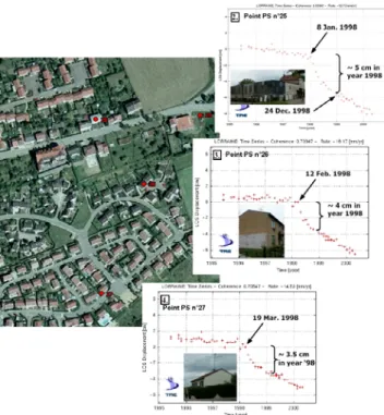
Assessment of radar techniques (conventional or advanced-InSAR) for the characterization of the physical behavior of buildings and the supply of vulnerability parameters is ongoing. Methodological examples are generated concerning deformation parameters acting on buildings (linearity of the movements or not, the gradient, and others). First results of these studies are presented here. The demonstration concerns Permanent Scatterer (PS) approach. Space-borne differential radar interferometry provides a unique tool able to give a synoptic view of ground deformation with centimetric to millimetric vertical precision. Approaches for combining a wide range of radar images such as the PS technique allow the estimation of the deformation history of single buildings. A detailed description of this technique can be found in Ferretti et al. (2000, 2001). The PS approach has been exploited to investigate a test site particularly exposed to ground deformation hazards, namely the iron mining basin in Lorraine (France) (Colesanti et al., 2005). Despite the rural environment, the average PS spatial density resulted in 60 PS.km-2 (Fig.2). Clear collapse precursor signs have been identified in the 10 months
preceding a major collapse event, inducing severe damage to houses (maximal vertical amplitude of 59 cm). The comparison with available levelling measurement after the collapse itself shows a close match (differences in the order of 1–5 mm) between in situ and spaceborne measurements.
Figure 2. Monitoring of ground instabilities due to historical iron mining activity using Permanent Scatterers (PS) technique from ERS SAR images (processing by TRE). Precursor signs of a collapse affecting an area of 300x300m2 have been identified.
4. CONCLUSION
In summary, our project addresses multi-risk assessment for natural disasters through homogenised and global methodologies, in order to improve disaster preparedness and mitigation. Focused on seismic, volcanic and ground instability hazard assessment, the project’s strategic framework attempts to encompass using a system perspective the whole chain of environmental information flow, from observing, monitoring and other data collection, through assessment, modelling and other value-added data processing. This integrated observing, assessment and reporting framework will be developed at nested geographic scales including global, national, regional and local levels.
The capability of investigating the deformation before a major collapse (when no levelling data were recorded) suggests that a relevant application of the PS technique could be envisaged for the detection of collapse precursors. Anyway, for achieving operational capability, a shorter revisit time would often be required. Moreover, other collapse events occurred (also in similar geological and mining contexts) without clear evidence of known precursor signs. A deeper analysis of several different cases should, therefore, be performed to generalize the approach. Nevertheless, this study clearly shows the important role that the
PS technique as well as other advanced multi-interferogram radar interferometry approaches, could play in land-use planning and natural or anthropogenic risk assessment. In particular, these approaches could be exploited systematically on large areas (100x100 km2) to optimize and drive other ground control methods such as optical levelling and microseismicity techniques, which can be used locally to set up a real-time alert system The demonstration will also include the potential of using subpixel correlation applied to optical imagery to measure lateral displacements. These measurements are complementary to vertical displacements provided by InSAR techniques. The goal is to assess the capacity of new generation instruments (C, L, X radar band and very high resolution optical sensors) to contribute to the estimation of infrastructure vulnerability.
5. REFERENCES
M. Bour, P. Mouroux, “An advanced approach for earthquake risk scenarios with application to different european towns”, Earthquake loss estimation and risk reduction, European Seismological Commission, Nice, France, April 20-24, 2002. Carnec, C., Delacourt, C., 2000, “Three years of mining subsidence monitored by SAR interferometry, Gardanne, France”, Journal of Applied Geophysics, 43, 1, pp 43-54.
C. Colesanti, S. Le Mouelic, M. Bennani, D. Raucoules, C. Carnec, A. Ferretti, “Detection of mining related ground instabilities using the Permanent Scatterers technique - A case study in the East of France”, International Journal of Remote Sensing, vol26,1, p.p. 201-207, 2005.
A.Ferretti, C. Prati. and F. Rocca., « Nonlinear subsidence rate estimation using Permanent Scatterers in differential SAR interferometry », IEEE Transactions on Geoscience and Remote Sensing, 38, p.p. 2202–2212, 2000.
A.Ferretti, C. Prati. and F. Rocca., « Permanent Scatterers in SAR interferometry », IEEE Transactions on Geoscience and Remote Sensing, 39, p.p. 8–20, 2001
S. Le Mouélic, D. Raucoules, C. Carnec, C. King, « A Least-squares adjustment of multi-temporal InSAR data – Application to the ground deformation of Paris », Photogrammetric Engineering and Remote Sensing, vol.71, 2, p.p.197-204, 2005.
P. Mouroux, M. Bour, E. Bertrand, B. Lebrun, Ph. Masure, C. Martin, O. Monge, “Projet européen RISK-UE”, Aspects dynamiques et vibrations et Génie Civil, 6ème Colloque National AFPS 2003, Palaiseau, France, July 1-3, 2003.