HAL Id: hal-00304983
https://hal.archives-ouvertes.fr/hal-00304983
Submitted on 1 Jan 2004HAL is a multi-disciplinary open access archive for the deposit and dissemination of sci-entific research documents, whether they are pub-lished or not. The documents may come from teaching and research institutions in France or abroad, or from public or private research centers.
L’archive ouverte pluridisciplinaire HAL, est destinée au dépôt et à la diffusion de documents scientifiques de niveau recherche, publiés ou non, émanant des établissements d’enseignement et de recherche français ou étrangers, des laboratoires publics ou privés.
modelling in the High Atlas Mountains of Morocco
O. Schulz, C. de Jong
To cite this version:
O. Schulz, C. de Jong. Snowmelt and sublimation: field experiments and modelling in the High Atlas Mountains of Morocco. Hydrology and Earth System Sciences Discussions, European Geosciences Union, 2004, 8 (6), pp.1076-1089. �hal-00304983�
Snowmelt and sublimation: field experiments and modelling in the
High Atlas Mountains of Morocco
Oliver Schulz and Carmen de Jong
Department of Geography, University of Bonn, Meckenheimer Allee 166, 53115 Bonn, Germany Email for corresponding author: [email protected]
Abstract
Snow in the High Atlas Mountains is a major source for freshwater renewal and for water availability in the semi-arid lowlands of south-eastern Morocco. Snowfall- and snow-ablation monitoring and modelling is important for estimating potential water delivery from the mountain water towers to the forelands. This study is part of GLOWA-IMPETUS, an integrated management project dealing with scarce water resources in West Africa. The Ameskar study area is located to the south of the High Atlas Mountains, in their rain shadow. As a part of the MGoun river basin within the upper Drâa valley, the study area is characterised by high radiation inputs, low atmospheric humidity and long periods with sub-zero temperatures. Its altitude ranges between 2000 m and 4000 m, with dominant north- and south-facing slopes. Snowfall occurs mainly from November to April but even summit regions can become repeatedly devoid of snow cover. Snow cover maps for the MGoun basin (1240 km²) are derived from calculations of NDSI (Normalized Difference Snow Index) from MODIS satellite images and snow depth is monitored at four automatic weather stations between 20004000 m. Snowfall events are infrequent at lower altitudes. The presence of snow penitentes at altitudes above 3000 m indicates that snow sublimation is an important component of snow ablation. Snow ablation was modelled with the UEB Utah Energy Balance Model (Tarboton and Luce, 1996). This single layer, physically-based, point energy and mass balance model is driven by meteorological variables recorded at the automatic weather stations at Tounza (2960 m) and Tichki (3260 m). Data from snow pillows at Tounza and Tichki are used to validate the models physical performance in terms of energy and water balances for a sequence of two snowfall events in the winter of 2003/4. First UEB modelling results show good overall performance and timing of snowmelt and sublimation compared to field investigations. Up to 44% of snow ablation is attributed to snow sublimation in typical winters with subzero temperatures and low atmospheric humidity at an altitude of 3000 m. At altitudes below 3000 m snowmelt generally dominates over sublimation. Unfortunately, the highest altitude zones suffer long periods with direct water loss into the atmosphere by sublimation in the course of which they cannot contribute to direct runoff or groundwater formation in the southern High Atlas Mountains.
Keywords: sublimation, snow ablation modelling, energy balance model, High Atlas Mountains
Introduction
Snow is an important factor determining water availability in semi-arid and arid mountain regions around the world. In the Mediterranean, a substantial part of freshwater resources is stored, temporarily, in the form of snow. In such regions, mountains are essential since they increase liquid and solid precipitation and feed rivers that transport snow meltwater to the lower and more arid regions. In Lebanon, for example, meltwater can contribute to approximately two-thirds of the total annual volume of discharge (Shaban, 2004). In Morocco, however, the uneven and erratic nature of rain and snowfall and large evaporation losses, especially in the High Atlas Mountains, cause major water management problems (Water Sector Review of the World Bank, 1994).
Although the country has made major efforts to meet the challenges in water management of the 21st century, it requires more efficient water distribution to assure sustainable water management in drought-prone regions.
Therefore, snow research in Morocco is becoming of increasing interest to water management institutions. Snow from the High Atlas Mountains is a major source for freshwater renewal and for water availability in the semi-arid lowlands of south-eastern Morocco. Agriculture in the mountain valleys and the foreland basins depends on irrigation by canals diverted from snowfed rivers. Drinking water in mountain areas is limited to springs connected to the villages by plastic pipes, while groundwater extraction is increasingly important further downstream. In the Drâa
basin, all major rivers from the High Atlas Mountains and the Anti-Atlas enter the El Mansour Eddahbi reservoir near Ouarzazate. After dry winters with limited snow and rainfall the actual storage in the dam may decrease in summer to a minimum of 20% of its maximum filling level. As indicated by more than 40 years of data from the DRH (Direction Regional lHydraulique), one large regional rainfall event can refill the dam by up to 3540%.
Snowfall in the High Atlas Mountains usually occurs from October to May but the snow cover is rarely continuous (Youbi, 1990). As indicated by its highly contrasting cover on windward and leeward slopes, snow redistribution by wind is important; coupled with rapid snowmelt, redistribution processes are a challenge in the analysis and modelling of snow evolution and snowmelt. Although models of snow redistribution exist for complex mountainous terrain (e.g. Liston and Sturm, 1998) the variability of wind processes (Gauer, 1999) and snow characteristics still pose a major challenge.
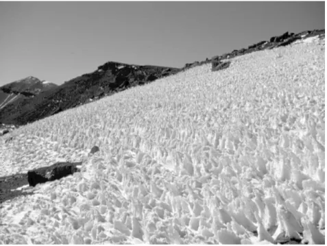
Snow ablation in arid environments is characterised by two important processes: snow melt and sublimation. Sublimation is defined as a phase change from ice to water vapour. A prerequisite for this is a vapour pressure deficit in the air above the snow layer. Increased rates of sublimation are achieved as wind speed or solar radiation increase the turbulent exchange or the amount of energy available for the phase change, respectively. Rising air temperatures support sublimation as long as the snow pack is cold and snow-melt does not dominate. Mountain areas provide good conditions for sublimation due to a decrease in vapour pressure and increase in wind speed with elevation (Gray and Prowse, 1993). Where snow sublimation is an important component of snow ablation, snow penitentes can evolve as pointed, hat-like peaks of old and hardened snow during weeks of cold and arid conditions. Penitentes, observed, except in Antartica, in high mountain areas world-wide wherever snow is subject to a cold and arid climate (Troll, 1942; Lliboutry, 1954; Beaty, 1975; Becht, 1991; Corripio, 2005), have not previously been reported in Morocco. Several theories have been developed on the formation of snow and ice penitentes. According to Lliboutry (1954) and Corripio (2004), the process of penitentes formation requires a cold and arid environment with a dew point below zero and high solar radiation. Penitentes are always orientated towards the sun. They develop when radiation is trapped within the evolving micro-topography of the snow layer. Penitentes experience reduced melt loss but enhanced sublimation rates compared to their surroundings. Melting occurs in the hollows of the penitentes due to air moisture saturation at reduced wind speeds. The differences between the sublimating top and the melting
lower walls and bottom of the penitentes are reinforced by this process. The main factors causing penitentes to melt are rising temperatures and changing snow properties at the end of winter.
In the Alps, snow evaporation is less important on a seasonal basis or for water balance estimations (Lang, 1981; Blöschl in Tarboton et al., 2000). According to Braun (1985) snow evaporation is significant only over short periods in that type of environment. The situation is very different in arid regions. Water loss by snow sublimation is problematic in regions where water is scarce and where snow is a major source of the manageable freshwater supply.
Global comparison of sublimation shows that, in arid environments, sublimation plays a major role in snow ablation. Gray and Prowse (1993) found that 40% of annual snowfall in Canada is lost by sublimation. Beaty (1975) reported on the significance of sublimation in the White Mountain Range, California. At 37°N, the White Mountains lie in the rain shadow of the Sierra Nevada and have arid climatic conditions at the border to the Mojave Desert and Death Valley. Simple experiments by Beaty showed that there was a remarkably limited amount of surface runoff. Approximately 5080 % of the total springtime snow pack was estimated to sublimate and/or evaporate in regions above 3500 m, mainly in the early summer. Vuille (1996) measured sublimation in the southern Altiplano of the South American Andes and showed that it could amount to 30%, 60% and 90% of the seasonal snow water equivalent (SWE) at altitudes of 3000 m, 4000 m and 5000 m respectively. Maximum sublimation rates of 12 mm per day were recorded. Becht (1991) also found large sublimation losses of snow water at the Pico de Teide (Tenerife, Canary Islands). Investigations on the isotopic composition of snow showed an enrichment of ²H and 18O isotopes in the upper
layers of snow indicating high evaporation. Various investigations with lysimeters indicated that water losses during cold and arid conditions were not caused by melt (Becht and Trimborn, 1993).
In Morocco, the southern slopes of the semi-arid High Atlas Mountains are an ideal environment for snow ablation due to both the altitudinal and the seasonal alterations in melting and sublimation. Snow isotope samples taken from the MGoun area of the High Atlas are under investigation. The results will be used to support the snow ablation and groundwater modelling in the future.
Monitoring snow under semi-arid conditions has to involve techniques with an adequate spatial and temporal resolution because of the rapid changes in the scarce snow cover. Satellite images provide an adequate tool to cover large areas in small time steps (Hall and Martinec, 1985). As the temporal resolution increases, the spatial resolution
becomes coarser, limiting its applicability in mountain regions with small ridges and steep valleys. Since a high spatial resolution does not usually coincide with rapid satellite return time, the monitoring of snow depletion under rapidly changing snow conditions is difficult in mountain ranges such as the High Atlas. Automatic weather stations (AWS) recording hourly report only at-a-point changes in snow properties. Where feasible, terrestrial cameras can be used to monitor meteorological conditions and snow distribution or redistribution in the area surrounding the AWS and on the slopes of the opposite side of the valley (Corripio et al., 2004; Schmidt, 2005).
Snowmelt modelling involves different approaches and strategies that depend on the aim of research, data availability and the natural environment in which the modelling is applied. Most modelling approaches are focused on long duration and thick snow cover which causes problems for model calibration in arid mountains where snow cover is more sparse and discontinuous. Simple degree-day models such as the SRM Snowmelt Runoff Model (Martinec et al., 1998) are less data-intensive and easier to automate. By combining parameters from different hydrological processes, the number of parameters is minimised. In the degree-day models, snowmelt is delayed considerably when factors other than positive air temperature are responsible for mass losses but the real decrease of SWE by evaporation or sublimation cannot be differentiated. The runoff coefficient in the SRM is a parameter which can be adjusted to reduce the amount of modelled runoff in relation to the overall water input from precipitation. Abidi (1989) applied the SRM to the Tillouguit basin in the northern High Atlas Mountains. He had to minimise recession coefficients for snow and rain in the model to reach the observed amount of runoff. On the one hand, this may be caused by infiltration losses in the geologically complex mountain environment but, on the other hand, it could be due to loss of snow water to the atmosphere. No analysis of background processes was carried out (Abidi, 1989) since the calibration of parameters from combined processes does not require knowledge about the specific processes involved.
Modelling snowmelt in arid environments should be based on physical approaches that calculate the energy balance and that can differentiate between melt and sublimation. The UEB (Utah Energy Balance Model) is a physical model that is suitable for application in arid environments. Whilst UEB can be coupled with hydrological models, the SRM is a full stand-alone model from precipitation to runoff. Snow depletion monitoring and modelling are important for estimating water delivery and water availability from the mountain water towers and to the forelands. As part of the GLOWA-IMPETUS project (GLOWA: Global Change in
the Hydrological Cycle IMPETUS: an integrated approach to the efficient management of scarce water resources in West Africa) this study contributes to the goal of developing tools for efficient management of the scarce water resources in the Drâa region, Morocco. Snow depletion monitoring and modelling methods have to be adapted to the climatic conditions of this semi-arid environment.
Accordingly, the aims of this paper are threefold: (1) to monitor snowfall and ablation in the field with an
appropriate temporal resolution,
(2) to investigate regional snow cover distribution with satellite imagery,
(3) to model snow dynamics, in particular sublimation with the UEB energy and mass balance model.
Study area
The Ameskar study area is located in the MGoun mountain region on the southern and drier side of the High Atlas Mountains at 31.5° N and 6.5° W (Fig. 1). The highest peak in the region is the Jebel MGoun (4070 m). The altitude of the study area of 140 km² ranges from 2000 m to 4000 m and north- and south-facing slopes dominate the catchment. The catchment consists of complex, highly folded geological units, mainly limestone, basalt, syenite, silt, sandstone and gypsum. Geomorphologically, the basin includes rockfaces, extensive scree slopes, debris flow channels, debris fans, ancient and active landslides and coarse, gravelly river beds (de Jong et al., 2004). Vegetation is scarce and dominated by scattered juniper trees between 20002400 m, cushion shrubs above 2400 m and accacia wadi communities in the rivers and dry wadi beds. In the valleys, irrigated Mediterranean fruit and vegetable oases dominate. The Assif-n-Ait-Ahmed (assif means river) drains the Ameskar valley and joins the MGoun river which in turn joins the Dadès river. The Dadès river is the most important tributary to the large Mansour Eddahbi reservoir near Ouarzazate (Youbi, 1990).
The southern parts of the High Atlas Mountains are characterised by their leeward exposure to winter storm tracks from the Atlantic Ocean. Knippertz (2003) traced the origin of moisture both to the Atlantic Ocean in winter and to air masses moving from the tropics in the direction of the High Atlas Mountains in summer. The MGoun range is part of the principal mountain divide in Morocco and forms a transition to the Anti-Atlas and the pre-Saharan forelands. Located within the upper part of the MGoun river basin (1240 km²), the Ameskar study area is characterised by high radiation inputs, low atmospheric humidity and periods with subzero temperatures in winter.
30° N 10° W Ameskar M‘Goun basin 4068m M ‘G ou n Dad ès 10 km Kela Mgouna 1420m M‘Goun basin Tichki 3260 m
*
Tounza 2960 m*
*
automatic weather station snow pillow 30° N 10° W 30° N 10° W Ameskar M‘Goun basin 4068m M ‘G ou n Dad ès 10 km Kela Mgouna 1420m Ameskar M‘Goun basin 4068m M ‘G ou n Dad ès 10 km Kela Mgouna 1420m M‘Goun basin Tichki 3260 m
*
Tounza 2960 m*
*
automatic weather station snow pillow M‘Goun basin Tichki 3260 m
*
Tounza 2960 m*
*
automatic weather station snow pillow
Fig. 1. Map of the Ameskar study area within the MGoun basin, Upper Drâa Valley, south-eastern Morocco. The enlargements show the
humidity were collected by Wiche (1953) on the southern slopes of the MGoun mountain range. Precipitation amounts, extrapolated from stations in the northern and southern forelands, were 700800 mm per year for the highest region of the Jebel MGoun for the time-series of 192550 (Carte des Precipitations, 1957) and 600800 mm (Ministere de lHabitat et de lamenagement du Territoire). In the valleys, precipitation diminished to 200 mm.
Wiche (1953) and Messerli (1967) state that glaciers occur only on the northern slopes of the High Atlas. Avalanche activity is also confined to the northern parts of the Atlas. Snowfall events occur mainly from November to April and even in the highest regions they are interrupted by periods of complete snow ablation. Sublimation of snow is often characterised by snow penitentes with a height of up to 70 cm at altitudes above 3000 m in late winter (Fig. 2).
Methodology
The methodology is threefold: Monitoring of snow by meteorological and hydrological measurements; analysis of satellite images; snow melt and sublimation modelling with an energy balance model.
METEOROLOGICAL DATA
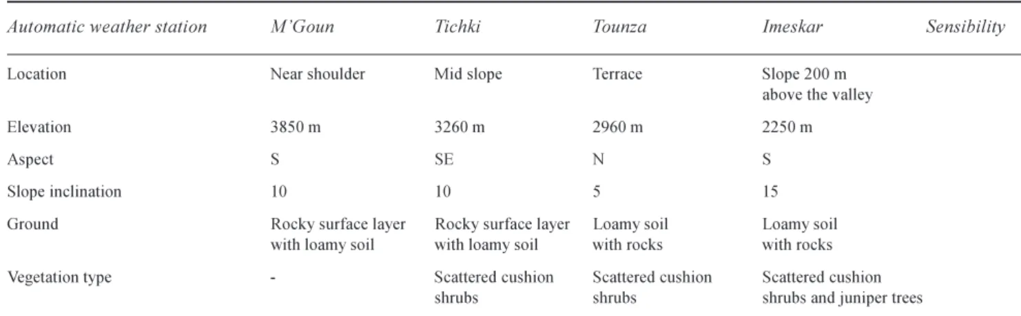
Five Automatic Weather Stations (AWS) of the IMPETUS
project were installed in 2001 in the MGoun region at altitudes between 1900 m and 3850 m (Table 1). The data set was complete for the years 2001/2 and 2002/3.
The stations measure standard meteorological variables such as air temperature and humidity, soil temperatures, wind speed and direction, solar irradiance, net radiation and precipitation. The three highest stations are equipped with ultrasonic snow depth sensors, infrared temperature sensors for surface temperature measurements and temperature probes (thermistors) for snow pack temperatures. Meteorological measurements, averaged over 15 minute and hourly intervals, and daily means and totals are calculated from these.
Precipitation measurements for the years 20012004 comprise direct measurements of liquid precipitation and snow in unheated tipping bucket rain gauges and calculations of snow water equivalent for freshly fallen snow. Winter precipitation falls mainly as snow (Tichki AWS, 3260 m and Tounza AWS, 2960 m), only as snow (MGoun AWS, 3850 m), or episodically as snow (Imeskar AWS, 2250 m). Comparison of rain gauge data with snow depth data showed that snow was not measured correctly in the rain gauges. Since the initial snow water equivalent (SWE) after snowfall had to be estimated without measurements for most of the time series, SWE was calculated from snow depth. Estimations of initial snow density were supported by individual snow density
Fig. 2. Penitentes in the MGoun Range at 3600 m. The penitentes are south-oriented and have a size of up to 70 cm. The MGoun automatic
Table 1. Automatic weather stations of the IMPETUS project in the Ameskar study area.
Automatic weather station MGoun Tichki Tounza Imeskar Sensibility
Location Near shoulder Mid slope Terrace Slope 200 m above the valley Elevation 3850 m 3260 m 2960 m 2250 m
Aspect S SE N S
Slope inclination 10 10 5 15
Ground Rocky surface layer Rocky surface layer Loamy soil Loamy soil with loamy soil with loamy soil with rocks with rocks Vegetation type - Scattered cushion Scattered cushion Scattered cushion
shrubs shrubs shrubs and juniper trees
SENSORSAT CAMPBELL SCI. AUTOMATICWEATHERSTATIONS:
CR10X data logger, SM4M storage modules, multiplexer AM416, solar panels (20W), 12V battery
SENSORINSTALLATIONHEIGHTINMETRES
Air temperature and relative 2.0 2.0 2.0 2.0 + 0.1 °C humidity probe HMP45C
Wind speed: 3 3 3 3 + 0.1 m s1
A100R switching anemometer
Wind direction: 3 3 3 3 + 2°
W200P potentiometer windvane
Tipping bucket 1.80 1.80 1.80 1.80 Tip capacity
rain gauge R102 0.2 mm
Solar irradiation: 2.5 2.5 2.5 2.5 +10 % CM3 pyranometer sensor (305 2800 nm)
Net radiation: 2.5 2.5 2.5 2.5 + 10 %
NR-Lite (0,2 100 µm)
SR50 ultrasonic snow depth sensor 1.8 1.8 1.8 1.8 +2 cm Snow pillow (distance from AWS) 70 20
Infrared surface temperature 1.8 1.8 1.8 + 0.3 °C sensor IRTS-P
Temperature probe 107 (thermistor) 0.1, 0.2, 0.3, 0.5, 0.7 0.1 0.1, 0.3 + 0.1 for snow pack temperature
measurements shortly after snowfall events and more recently by comparisons between snow depth and snow pillow data. From this, the density of new snow was estimated to be 0.15 for the three AWS in the higher regions. Initial SWE was then calculated from maximum snow depth after snowfall assuming a snow density of 0.15. Precipitation measured in the rain gauge at air temperatures below 1°C was assumed to be snow and counted directly as SWE if there were no changes in snow depth.
Two snow pillows were installed in 2003 and connected to the AWS at Tichki (3260 m) and Tounza (2960 m). The
snow pillows were 70 m away from the Tichki AWS and 20 m away from the Tounza AWS in homogenous topography with a slope inclination of less than 10°. The terrain was levelled and covered with sand to establish a horizontal, well-drained foundation for the snow pillow. A terrestrial digital camera was placed next to the MGoun AWS (3850 m) to observe the influence of weather on climate measurements and snow redistribution. Data series showed that, during snow storms, the ultrasonic snow depth sensors did not work properly.
REMOTE SENSING
In mountain areas with large differences in topography, snow cover distribution and rapid redistribution, satellite images provide a good overview of regional changes from one time step to the next. However, a choice has to be made between a high spatial and high temporal resolution. In the MGoun mountain region, the snow cover shortly after snowfall is often restricted to the higher altitudes. In monitoring the rapid build-up and decay of snow cover over the mountain range, priority was given to high temporal resolution. The Moderate Resolution Imaging Spectroradiometer (MODIS) on the TERRA satellite with 500 m resolution and daily coverage was preferred to the coarser NOAA-AVHRR Scenes. The Land Processes Distributed Active Archive Center of the USGS provides several different MODIS products. In this study, the product MOD09GHK Surface Reflectance Daily L2G Global 500m was chosen to calculate the Normalized Difference Snow Index (NDSI).
The MOD09GHK is a seven-band product computed at the MODIS level 1B land bands 17. It estimates the surface spectral reflectance for each band as if it had been measured at ground level without atmospheric scattering or absorption. The images are fully corrected for atmospheric gases, aerosols and thin cirrus clouds, and registered to a sinusoidal projection by LPDAAC (2004). The MOD09GHK images were applied directly. The NDSI is described by Hall et al. (1998). Here, it is calculated with the green band and the infrared band (1,6 µm) without further corrections for water surfaces using the equation:
NDSI = (NIR-G) / (NIR+G)
with NDSI = Normalized Difference Snow Index, NIR = Near Infrared Band and G = Green Band.
A threshold value is required to distinguish between snow and snow-free pixels. A comparison of snow classification in the study area for the same day with a high resolution TERRA-ASTER image (15 m resolution) and a MODIS image produced a threshold value of 0.3 for pixels that have a 50% or higher snow cover. This result differs from that of Hall et al. (1998) who obtained a threshold value of 0.4. Salomonson and Appel (2004) propose a correlation between classified Landsat images and the MODIS NDSI to estimate the fractional snow cover within a MODIS pixel. They arrive at a threshold value of 0.36 for a 50% snow cover. The differences noted for the NDSI thresholds could be due to different snow classifications in the high resolution images and to regions of shallow snow cover in the Moroccan images. It is planned that the approach of fractional snow cover analysis will be applied to the Moroccan time series.
Snow masks were calculated for the High Atlas Mountains from 2001 to 2003 from MOD09GHK data with the NDSI threshold value. The quantity of images used was dependent on the availability and quality of corrected data and cloud cover. Fractional snow cover within the MGoun river basin was calculated in ArcGIS for elevation zones of 500 m based on a 30 m Digital Elevation Model from the snow masks zonal statistics of average fractional snow cover.
SNOW ABLATION MODELLING
To model snow ablation, the UEB Model, a single layer point energy and mass balance model for snow accumulation and melt, was chosen. The model uses physically-based calculations of radiative, sensible, latent and advective heat exchanges and a lumped representation of the snow pack with two primary state variables, namely, water equivalence and energy content relative to a reference state of water in the ice phase at 0°C. Albedo is calculated according to snow surface age (Tarboton and Luce, 1996). The model is driven by meteorological measurements recorded at the Tichki (3260 m) and Tounza (2960 m) AWS in the upper parts of the Ameskar study area. Meteorological variables include air temperature and humidity, wind speed, solar irradiance and precipitation. The model calculates the energy content of the snow and underlying soil layer at hourly time steps to determine average snowpack temperature or the liquid fraction. A positive energy content means that some snow is melting; a negative energy content is used to calculate the snow pack average temperature (Tarboton and Luce, 1996). For the snow cover sequence from November to December 2003, the measurements at the Tichki and Tounza AWS and snow pillows were compared with UEB model outputs to validate its physical performance in relation to the energy and water balances. Standard parameters were used in the model according to calibration results of Tarboton and Luce (1996) from the CSSL Central Sierra Snow Laboratory, California. The parameters include surface aerodynamic roughness (0.005 m) and snow surface thermal conductance (0.02 m h1). No parameter calibration was
carried out since the modelled results matched the observed timing of snow ablation and snow water equivalent reasonably well. All parameters were fixed at their default values (Tarboton and Luce, 1996).
At Tichki the model was initialised on the 26th November with a SWE of 96 mm. The temperature of the snow/soil layer was calculated from soil, snow pack and snow surface temperature measurements and averaged to 2°C. Modelling at Tounza was initialised on the 27th November with a SWE of 29 mm. The averaged temperature of the snow/soil layer was 2°C.
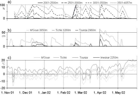
a) b) c) a) b) c)
Fig. 3. Meteorological data from the IMPETUS automatic weather stations in the Ameskar study area and snow cover fraction calculated with
MODIS snow maps on a Digital Elevation Model for the MGoun river basin in 2001/02. a) snow cover fraction for 500 m elevation zones, b) snow depth measurements and c) air temperature measurements at the automatic weather stations in the Ameskar study area, respectively.
Results and discussion
METEOROLOGICAL DATA AND MODIS SNOW DISTRIBUTION
Measurements of precipitation during the IMPETUS project between 20012004 show that the relation between snow and rain increases with altitude with a ratio of 1:4 to 4:1 between 2250 m to 3850 m. Precipitation measurements and calculations indicate a high variability in the annual sum of liquid precipitation (53%) and a low variability in snow precipitation (13%) for the highest AWS at 3850 m (MGoun). Here, the average amount of total precipitation for two full years amounts to 775 mm.
Snowfall on the southern slopes of the High Atlas occurs regularly between November and April with some early and late events in October and May (e.g. 2004, end of May). Seven to twelve snowfall events during winter have been observed in recent years; therefore, the duration of snow cover is usually limited to periods of under 30 days. Between snowfall events snow usually ablates completely at altitudes up to 3000 m, sometimes even in the highest regions at 4000 m (Fig. 3). Snow can be one to one and a half metres deep under favourable conditions with an average of only a few centimetres in the valleys below 2200 m and up to one metre on the higher mountain flanks above 3000 m.
In the winter of 2001/02, eleven snowfall events were registered at the highest AWS M´Goun (Fig. 3). The maximum daily mean snow depth was 65 cm on 1st April 2002. At the lower AWS Tichki (3260 m) and Tounza (2960 m), only five events brought sufficient snow cover to last for more than a few days, with a corresponding maximum on 1st April 2002. Other registered snowfall events had a snow depth barely <5 cm. Periods with snow cover were interrupted by periods with the ground completely snow-free at all altitudes. The maximum snow amount at the beginning of April 2002 decreased quickly due to positive air temperatures and dominant snow melt. In winter, the snow pack diminishes slowly which can be attributed to sublimation. Generally, snow depth is affected by the initial snow properties and environmental influences during and after snowfall. To provide more reliable data for calculation and modelling of snow ablation, data from the snow pillows were used. The SWE was used to initialise the UEB and to validate the modelled snow ablation. Since the pressure transducer of the snow pillow is sensitive to temperature and, therefore, causes large fluctuations during the daytime, nightly minima of the snow pillow measurements were chosen for comparison with snow melt modelling. Observations at the Tounza site in early March showed that the distribution of snow within the fenced snow
pillow site did not differ from the surrounding area. Control measurements of SWE around the snow pillow in Tounza agreed to 95% with the snow recorded pillow data.
A time series of snow cover maps, derived from 49 MODIS satellite image products for the winter of 2001/02,
was analysed according to percentage snow cover in altitudinal steps of 500 m for the M´Goun river basin using a Digital Elevation Model (Fig. 3). The snow ablation curves confirm that, in accordance with the single station measurements, snowfall events are infrequent at the lower
18.11.2002 27.11.2002 4.12.2002
20.12.2002 5.1.2003 12.1.2003
28.1.2003 18.2.2003 3.3.2003
19.3.2003 29.3.2003 11.4.2003
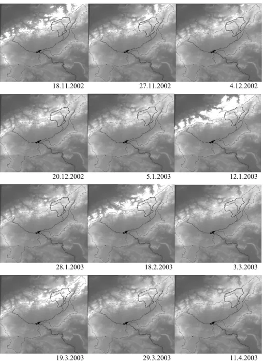
Fig. 4. Temporal sequence of snow maps of the High Atlas Mountains derived from MODIS satellite image analysis for the winter 2002/03.
The Normalized Difference Snow Index was calculated on the LPDAAC MODIS Surface Reflectance Product MOD09. Snow cover appears in white, while the DEM is stretched between light grey (mountains) and dark grey (middle Drâa valley in the south-east, basin of Marrakech in the north-west). Main rivers and the Mansour Eddahbi reservoir lake appear in black, the dashed black line marks the watershed of the 15 000 km² upper Drâa basin with the reservoir lake at the outlet. The solid black line marks the MGoun river basin. The snow maps are projected on a 30 m Digital Elevation Model calculated from ASTER satellite scenes.
altitudes and that snow cover is interrupted regularly by snow-free periods even in the highest zone above 3500 m. It is often difficult to demonstrate the existence of thin snow layers for one or two days when cloudy or foggy weather inhibits the visibility of satellites and produces climatic conditions with low diurnal variations in temperatures and radiation. The temporal sequence of snow maps for the winter 2002/03 demonstrates the rapid changes in snow cover and the climatic disadvantage of the region south of the High Atlas Mountains (Fig. 4). With the exception of the 19th March 2003, snowfall dominates the northern flanks of the High Atlas Mountains to the north of the Drâa basin.
UEB SNOW MODELLING
The UEB model (Tarboton and Luce, 1996) was used to model snow ablation processes at the Tichki (3260 m) and Tounza (2960 m) sites for the periods of 26th November 2003 to 3rd January 2004. Meteorological data from the Tichki and Tounza AWS were used to drive the model. For winter 2003/04, SWE data were derived from the snow pillows. These data provided the initial precipitation input for the snowfall events and the evolution of the SWE. The evolution of the modelled SWE at Tichki and Tounza generally followed the snow pillow measurements (Figs. 5 and 6). -20 0 20 0 100 200 26 28 30 2 4 6 8 10 12 14 16 18 20 22 24 26 28 30 1 3 0 100 200 d) e) f)
precipitation snow melt
sublimation
snow pillow UEB
IR sensor UEB st swe swe cum. -20 0 20 26 28 30 2 4 6 8 10 12 14 16 18 20 22 24 26 28 30 1 3 0 10 20 0 50 100 a) b) c) at rh ws
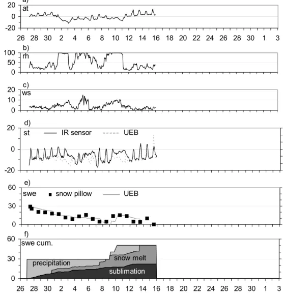
Fig. 5. Meteorological data and modelled and observed SWEs, snow melt and sublimation at the Tichki AWS (3250 m) in the High Atlas
Mountains from 26.11.20033.1.2004. SWE was measured with a snow pillow and modelled with the UEB. Snow melt and sublimation values are model results from the UEB Utah Energy Balance Model. (a) air temperature (°C), (b) relative atmospheric humidity (%), (c) wind speed (m/s), (d) measured infrared surface temperature (solid line, °C) and modelled surface temperature (dashed line, °C), (e) measured SWE (snow pillow, mm) and modelled SWE (UEB, mm),(f) cumulative precipitation (measured), sublimation and snow melt (modelled, UEB), all in mm.
From the 26th November 2003 at Tichki, there was an initial SWE of 96 mm after snowfall, followed by a slow decrease in SWE attributed mainly to sublimation with only one day of melt on the 30th November following three days of positive air temperatures, low atmospheric humidity and medium wind speed (Fig. 5). Sublimation stopped with the rise in atmospheric humidity caused by the next snow fall event. From the 8th to 15th December, SWE was decreased only by sublimation until the start of snow melt. After the 15th December until the day of total snow ablation (30/12) snow melt and sublimation had average daily rates of 5 mm and 3 mm, respectively. The sum of snow melt and sublimation over the modelled time period was 94 mm and 77 mm SWE, respectively. This means that 55% of the total
precipitation of 171 mm was melted and 45% was sublimated.
The missing values of the measured SWE from the snow pillow at Tichki in Fig.5e correspond mainly to unrealistically high daily snow pillow minima during periods of exceptionally high wind speed. Very low minima were recorded between the 19th and 21st December. This was possibly due to freezing at the base of the snow pillow on a day with sub-zero air temperatures following several days of snow melt. Towards the end of the modelling period, there are some missing snow pillow values due to error measurements under very thin snow cover.
Measured infrared snow surface temperatures agree well with modelled snow surface temperatures (Fig. 5d) as
Fig. 6. Meteorological data and modelled and observed SWEs, snow melt and sublimation at the Tounza AWS (2960 m) in the High Atlas
Mountains from 27.11. 15.12.2003. For consistency with Figure C3 the diagram is extended to the period 26.11.2003 3.1.2004. SWE was measured with a snow pillow and modelled with the UEB. Snow melt and sublimation values are model results from the UEB Utah Energy Balance Model. (a) air temperature (°C), (b) relative atmospheric humidity (%), (c) wind speed (m/s), (d) measured infrared surface temperature (solid line, °C) and modelled surface temperature (dashed line, °C), (e) measured SWE (snow pillow, mm) and modelled SWE (UEB, mm), (f) cumulative precipitation (measured), sublimation and snow melt (modelled, UEB), all in mm.
-20 0 20 0 30 60 26 28 30 2 4 6 8 10 12 14 16 18 20 22 24 26 28 30 1 3 0 30 60 d) e) f)
precipitation snow melt
sublimation
snow pillow UEB
IR sensor UEB st swe swe cum. -20 0 20 26 28 30 2 4 6 8 10 12 14 16 18 20 22 24 26 28 30 1 3 0 10 20 0 50 100 a) b) c) at rh ws
indicated by a Pearson correlation coefficient of 0.87 and a model efficiency of 0.8. Since the modelled snow surface temperature in the UEB model is calculated using an equilibrium approach that balances energy fluxes at the snow surface (Tarboton and Luce, 1996), the conformity of modelled and measured snow surface temperatures indicates that surface energy fluxes are modelled well. This provides a good foundation for the interpretation of the modelling results and the differentiation between sublimation and melt. The unusually high positive daytime surface temperatures of snow (up to 5°C) recorded with the infrared sensor were also reported by Tarboton and Luce (1996). UEB modelling results were very good for the time period chosen, as indicated by a Pearson correlation coefficient of 0.96 for the correlation between measured and modelled SWE and an overall model efficiency of 0.96.
At Tounza, there was 70% less snow than at Tichki in late 2003 (Fig. 6). The initial SWE to start the UEB model was 29 mm on 27th November and a total precipitation of 51 mm was reached after snow fall on 9th December. The increase in SWE measured by the snow pillow on the 5th December is not added to the model calculations for Tounza since the high wind speeds seem to distort the snow pillow measurements. Between the 27th November and the 7th December SWE decreased predominantly by sublimation apart from on one day with snow melt at the end of a four-day period with positive air temperatures and a warming snow pack. The daily sublimation rate of 2 mm is interrupted during periods of enhanced atmospheric humidity.
According to model results, snow melt starts again on the 7th December and leads to complete depletion of the snow pack on the 8th December. Under these minor snow depths, snow pillow measurements show a very small load of 4 mm SWE which could be interpreted as an inaccurate snow pillow recording due to an oasis-effect of remaining snow and water. A new snowfall event was recorded in the early morning of 9th December. Half of the 12 mm SWE was melted directly in the model due to the high energy content of the underlying ground. Another 10 mm was added to the remaining 6 mm by snowfall the following night. Snow melt and sublimation started again on the 11th and proceeded until complete ablation of the snow pack on the 13th December. The snow pillow indicated some snow remaining on the 12th and 13th December followed by an increase on the 14th and complete ablation by the 15th December. Modelled snow surface temperatures differed from those recorded at the AWS, indicating that the energy exchange at the snow surface was not modelled as well as at the Tichki site.
The total balance at Tounza for the period of 27th November to 15th December consisted of 22 mm of
sublimation to 29 mm of snowmelt which means that 43% of the SWE was lost to the atmosphere while 57% infiltrated into the soil. The Pearson correlation coefficient for the correlation between measured and modelled SWE was 0.76 and the coefficient of model efficiency was 0.91.
In general, some problems were encountered when initialising the UEB model. Firstly, the snowfall period at the Tichki and Tounza AWS began with a thin snow cover of less than 20 mm of SWE in mid-November 2003. Rapid snow melt in the preliminary model runs had to be compensated by parameter calibration which resulted in under-estimation of snow ablation later in the modelling period. Therefore, the model was started only when SWE reached higher values during the snow fall events on the 25th/26th of November. Secondly, modelling of snow-free periods indicated that the model had difficulties in calculating the soil energy for a snow-free surface. However, complete snow ablation occurred frequently during the selected winter season. Unrealistically high soil temperatures caused problems for consecutive model runs. Hence, periods with snow cover had to be modelled separately, which explains the short overall modelling times.
The differences between snow melt and sublimation at Tichki and Tounza could not be validated during the modelled period because no separate measurements of sublimation and melt were available.
However, observations of penitentes and simple measurements of snow ablation in the field confirmed the assumption that considerable sublimation occurs in winter. The low but continuous rates of snow ablation recorded by the snow pillows at the Tichki and Tounza AWS during cold and dry weather conditions were therefore attributed to sublimation. Wind redistribution of snow was not investigated but could have affected the results of the snow pillow measurements.
The good overall representation of ablation rates and the reasonable timing of snowmelt and sublimation in early winter of 2003 at Tichki and Tounza, coupled with general observations in the field during other periods, support the model results.
In general, snow sublimation dominates at an altitude of 3000 m in winter at low temperatures and atmospheric humidity. Since daily minimum air temperatures are generally above 0°C in winter, melt of the episodic and shallow snow cover may well dominate sublimation at the AWS at Imeskar (2250 m). In between this altitudinal belt, few data exist from single measurements. Here, the temporary extension of snow ablation processes has to be investigated further. At the MGoun AWS at 3850 m, snow ablation was not modelled because of difficulties in providing initial SWE. Sublimation is likely to play a more
important role in the zone above 3000 m since air temperatures remain below 0°C for longer periods in winter and wind speed and solar radiation increase with altitude. Thus the high altitude sublimation zone of the study area suffers from direct water losses into the atmosphere and does not contribute to runoff or groundwater recharge in the southern High Atlas Mountains.
Conclusions
Due to the strong climatic gradient between the Mediterranean and the pre-Saharan regions caused by the High Atlas Mountain Range, there are substantial differences in snow cover and in the dominance of snow ablation processes. A combination of field research, AWS, snow cover monitoring by satellite images and modelling of water and energy balances forms a suitable approach for investigating the role of snow under these conditions. Differences in the timing and rate of sublimation and snow melt at the two selected test sites, Tichki and Tounza, are influenced strongly by differences in snow depth and wind speed. The typically shallow snow cover and frequent high wind speeds influence not only the accuracy of snow pillow measurements but also of modelling results since parameters such as thermal snow conductance change rapidly in nature but are fixed in the model. Results show that large amounts of snow (on average 44%) are removed by sublimation during cold and dry climatic conditions in winter. Hence, to face the challenges of snowmelt modelling and snow water management on the southern sides of the High Atlas, emphasis has to be put on snow sublimation and evaporation processes. For the area of this study, snowfall at higher altitudes in winter does not normally last until spring but sublimates and melts within weeks. Therefore, the contribution of snow to water availability may well be insignificant during cold periods. This agrees with the conclusions of Beaty (1975), Becht (1993) and Vuille (1996) for other mountain areas under arid conditions, including the White Mountain Range in California, the Pico de Teide in Tenerife and the southern Altiplano of South America, respectively.
FUTURE WORK
Since differentiation of snow ablation processes is essential for the estimation of water availability in the region studied, modelling results for point locations have to be validated in more detail and distributed regionally. It is of interest whether more rain during the winter months in the mountains would be an advantage to the lowlands because of the
positive effects of decreased sublimation losses and increased infiltration on water availability. Since the Mansour Eddahbi reservoir dam in the Drâa catchment holds a large amount of water within the catchment for irrigation of the downstream regions, water availability is an important issue for further discussion. In this context it would be of future value to investigate whether the role of the reservoir is similar to that of snow in extending water availability into the dry season.
Acknowledgements
This project was funded by the German Federal Ministry of Education and Research (BMBF) under Grant No. 01 LW 0301A, and by the Ministry of Education and Research of North Rhine Westfalia under Grant No. 223-21200200, within the framework of the GLOWA-IMPETUS Morocco project (GLOWA Global Change in the Hydrological Cycle; IMPETUS an integrated approach to the efficient management of scarce water resources in West Africa). The authors appreciate the support of Professor M. Winiger, Dr. M. Nuesser and the members of the Climatology and High-Mountain Research Group (CLIMOUNT) at the Geography Department of the University of Bonn, as well as the help of IMPETUS Diploma and PhD students and staff, and of H. Boettger for technical assistance. The help of Mohammed, Lahcen and numerous inhabitants of the Ameskar valley and colleagues from the United States Department of Agriculture in Salt Lake City, Bob Nault and Tim Bardsley in setting up the snow pillows was invaluable.
References
Abidi, A., 1989. Martinec-Rango snowmelt runoff model applied
to the Tillouguit Basin of Morocco. Unpublished master thesis,
South Dakota School of Mines and Technology.
Beaty, Ch.B., 1975. Sublimation or melting: Observations from the White Mountains, California and Nevada, USA. J. Glaciol., 14, 275286.
Becht, M., 1991. Schneehydrologische Untersuchungen am Pico de Teide (Teneriffa). Erdkunde 45, 264276.
Becht, M., 1997. Zum Einfluß des Waldes auf die Schneeablation im Atlasgebirge Marokkos. Zeits. Gletscherkunde Glazialgeol., 33, 149168.
Becht, M. and Trimborn. P., 1993. Isotopenhydrologische Untersuchungen der Schneedecke am Pico de Teide (Teneriffa).
Zeits. Gletscherkunde Glazialgeol., 27/28, 151163.
Braun, L., 1985. Simulation of Snowmelt-Runoff in Lowland and Lower Alpine Regions of Switzerland. Zürcher Geographische
Schriften 21.
Corripio, J.G., 2004. Snow surface albedo estimation using terrestrial photography. Int. J. Remot. Sens., 25, 27055729. Corripio, J.G. and Purves, R.S., 2005. Energy Balance of High
Altitude Glaciarised Basins in the Central Andes: Climatic and Hydrological Aspects. In: Climate and Hydrology of Mountain
Areas, C. de Jong, D. Collins and R. Ranzi (Eds.), J. Wiley,
Corripio, J.G., Durand, Y., Guyomarch, G., Merindol, L., Lecorps, D. and Pugliese, P., 2004. Land-based remote sensing of snow for the validation of a snow transport model. Cold Regions Sci.
Technol., 39, 93104.
de Jong, C., Machauer, R., Reichert, B., Cappy, S., Viger, R. and Leavesley, G., 2004. An integrated geomorphological and hydrological MMS modelling framework for a semi-arid mountain basin in the High Atlas Mountains, southern Morocco. In: Complexity and Integrated Resources Management, C. Pahl-Wostl, S. Schmidt, A.E. Rizzoli and A.J. Jakeman (Eds.), Trans.
2nd Biennial Meeting International Environmental Modelling and Software Society, iEMSs: Manno, Switzerland. 736741.
Direction de lAgriculture et des Forets, 1957. Carte des
precipitations. Rabat/Paris.
Gauer, P., 1998. Blowing and drifting snow in alpine terrain: a physically-based numerical model and related field measurements. Mitteilungen der SLF 58 (Switzerland). Gray, D.M. and Prowse, T.D., 1993. Snow and floating ice. In:
Handbook of Hydrology, D.R. Maidment (Ed.), MCGraw-Hill,
New York, USA. 7.17.58.
Hall, D.K. and Martinec, J., 1985. Remote Sensing of Ice and
Snow. Chapman and Hall, London, New York.
Hall, D.K., Riggs, G.A. and Salomonson, V.V., 1998. Algorithm Theoretical Basis Document (ATBD) for the MODIS Snow and Sea Ice-Mapping Algorithms. http://modis-snow-ice.gsfc.nasa.gov/atbd.html
Knippertz, P., 2003. Long-term precipitation variability in Morocco and the link to the large-scale circulation in recent future climates. Meteorol. Atmos. Phys., 83, 6788.
Land Process Distributed Active Archive Center LPDAAC (2004): Product description of the MODIS MOD09GHK Dataset. [http:/ /lpdaac.usgs.gov/modis/mod09ghkv4.asp]
Lang, H., 1981. Is evaporation an important component in high alpine hydrology? Nord. Hydrol., 12, 217224.
Liston, G.E. and Sturm, M., 1998. A snow-transport model for complex terrain. J. Glaciol., 44, 498516.
Lliboutry, L., 1954. The origin of penitents. J. Glaciol., 2 (1952-56), 331338.
Martinec, J., Rango, A. and Roberts, R., 1998. Snowmelt Runoff
Model (SRM) Users Manual. Geogr. Bernensia, Series P, Vol.
35, Bern.
Messerli, B., 1967. Die eiszeitliche und die gegenwärtige Vergletscherung im Mittelmeerraum. Geographica Helvetica, 3, 228.
Ministere de lHabitat et de lamenagement du Territoire, Maroc:
Carte des precipitations. Atlas des Ressources naturels, Page
4. Rabat.
Salomonson, V.V. and Appel, I., 2004. Estimating fractional snow cover from MODIS using the normalized difference snow index.
Remot. Sens. Environ., 89, 351360.
Schmidt, S., 2005. Untersuchungen zur räumlichen und zeitlichen
Verteilung der saisonalen Schneedecke in Abhängigkeit zum Relief mittels terrestrischer Digitalaufnahmen im Lötschental (Wallis). Berliner Geographische Abhandlungen. (In press).
Schulz, O., de Jong, C. and Winiger, M., 2003. Snow depletion modelling in the High Atlas Mountains of Morocco. Geophys.
Res. Abs., Vol. 5, EGS-AGU-EUG Joint Assembly 2003.
Shaban, A., Faour, G., Khawlie, M. and Abdallah, C., 2004. Remote sensing application to estimate the volume of water in the form of snow on Mount Lebanon. Hydrolog. Sci. J., 49, 611621. Tarboton, D.G. and Luce, C.H., 1996. Utah Energy Balance Snow
Accumulation and Melt Model (UEB), Computer model technical description and users guide. Utah Water Research
Laboratory and USDA Forest Service Intermountain Research Station. http://www.engineering.usu.edu/cee/faculty/dtarb/ snow/snowrep.pdf
Tarboton, D., Blöschl, G., Cooley, K., Kirnbauer, R. and Luce, C., 2000. Spatial snow cover processes at Kühtai and Reynolds Creek. In: Spatial Patterns in Catchment Hydrology, R. Grayson and G. Blöschl (Eds.), Cambridge University Press.
Troll, C., 1942. Buesserschnee (nieve de los penitentes) in den Hochgebirgen der Erde. Petermanns Geographische
Mitteilungen Ergaenzungsheft Nr. 240.
Wiche, K., 1953. Klimamorphologische and talgeschichtliche Studien im MGoungebiet. Mitteilungen der Geographischen Gesellschaft Wien Bd. 95.
World Bank, 1994. Kingdom of Morocco. A water sector review. Unpublished.
Vuille, M., 1996. Zur raumzeitlichen Dynamik von Schneefall und Ausaperung im Bereich des südlichen Altiplano, Südamerika. Geographica Bernensia G45.
Youbi, L., 1990. Hydrologie du Bassin du Dadès. Ministere de lAgriculture et de la Reforme Agraire, Office Regional de Mise en Valeur Agricole de Ouarzazate. Ouarzazate.