HAL Id: insu-01664079
https://hal-insu.archives-ouvertes.fr/insu-01664079
Submitted on 14 Dec 2017
HAL is a multi-disciplinary open access
archive for the deposit and dissemination of
sci-entific research documents, whether they are
pub-lished or not. The documents may come from
teaching and research institutions in France or
abroad, or from public or private research centers.
L’archive ouverte pluridisciplinaire HAL, est
destinée au dépôt et à la diffusion de documents
scientifiques de niveau recherche, publiés ou non,
émanant des établissements d’enseignement et de
recherche français ou étrangers, des laboratoires
publics ou privés.
Analysis Methods for the Polarimetric WISDOM Radar
aboard the ExoMars Rover
D. Plettemeier, W.-St Benedix, C. Statz, Y. Lu, Yann Herve, Alice Le Gall,
Valérie Ciarletti
To cite this version:
D. Plettemeier, W.-St Benedix, C. Statz, Y. Lu, Yann Herve, et al.. Analysis Methods for the
Polarimetric WISDOM Radar aboard the ExoMars Rover. European Planetary Science Congress
2017, Sep 2017, Riga, Latvia. pp.EPSC2017-870. �insu-01664079�
Analysis Methods for the Polarimetric WISDOM Radar
aboard the ExoMars Rover
D. Plettemeier (1), W.-St. Benedix (1), C. Statz (1), Y. Lu (1), Y. Herve (2), A. Le Gall (2), V. Ciarletti (2) (1) Chair for RF and Photonics Engineering, Technische Universität Dresden, Dresden, Germany (2) LATMOS/IPSL, UVSQ Universités Paris-Saclay, UPMC Univ. Paris 06, CNRS, Guyancourt, France
Abstract
In this paper, we describe the capabilities of the fully polarimetric antenna system of the WISDOM GPR aboard the ExoMars rover in terms of a polarimetric data analysis as well as the setting and procedure for left-right-detection and entropy-based classification of (buried) objects. By means of different experiments (laboratory, artificial environment, and field tests [3]) the principles are validated. The evaluation of radargrams allows the lateral discrimination of the position of scatterer with regard to the path of the rover. A rough classification of objects and single subsurface features is performed by applying the entropy-alpha decomposition (H-α).
1. Introduction
The main scientific objective of the ExoMars 2020 mission is to search for traces of past or present life on Mars. The experiment WISDOM is one of the panoramic instruments aboard the rover and allows the sounding of the shallow subsurface to about three meters of depth [1]. Thus, the search for places of high scientific interest where the drill aboard the ExoMars rover might take drilling samples from a depth down to two meters is supported by WISDOM. Depending on the ground permittivity, the expected vertical radar resolution is around 10 cm or less, if the full bandwidth from 0.5 GHz to 3 GHz is used. During the mission, planned to last 218 sols, WISDOM will work in different scanning modes (e.g. long traverse scanning between science areas or zigzag-scanning at the area of interest). The method of left-right-evaluation for buried objects will be very helpful for long traverse scans since it provides additional information about the location of scatterers. The entropy-based polarimetric classification of localized buried scatterers and subsurface features in
combination with processed data from other instruments (e.g. PanCam) will allow a short-term decision whether any additional places along the traverse are worth investigating.
2. Left-Right detection
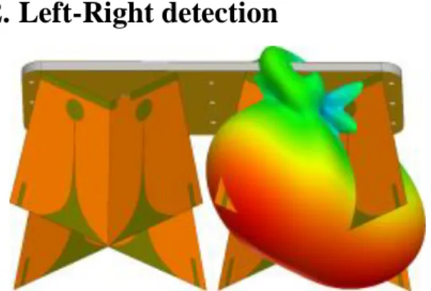
Figure 1: Simplified CAD model of the WISDOM antennas assembly with a radiation pattern at 2 GHz. The antenna of the WISDOM radar consists of two crosswise arranged two-element Vivaldi arrays (see Fig. 1), which work over a wide bandwidth ratio of 6:1 and allow an ultralight weight construction. Due to this crosswise arrangement, one can record four orthogonal transfer-functions: two co-polar and two cross-polar. The radar itself is of the SFCW type [2]. To produce a radargram, the data recorded in the frequency domain has to be inverse Fourier transformed to the time domain. Moreover, some filters are applied to remove clutter and antenna coupling. The pattern of the WISDOM antenna assembly exhibits a small beam at the E-plane and a wide beam at the H-plane, as shown in Fig. 1 for 2 GHz. The antenna assembly is placed at the rear side of the ExoMars rover with a clearance of about 35 cm to the ground. Further, the antenna crosses are rotated by 45°. with respect to the direction of rover motion, as shown in Fig. 2. In addition to the detection of buried objects this particular EPSC Abstracts
Vol. 11, EPSC2017-870, 2017
European Planetary Science Congress 2017 c
arrangement allows the localization of objects left or to the right of the rover path. The procedure is described in the following. Let's assume an object is arranged e.g. on left of the rover path. Then this object is first illuminated by the beam of the transmitting antenna T1. Then the receiving antenna R3 will receive the main part of the reflected power (assuming that the object’s influence on the polarization of the incident wave can be neglected). By further moving the rover ahead, the illumination of the object by antenna T1 will decrease and the influence of antenna T2 will increase. In the end, one obtains a hyperbola in both co-polar radargrams (T1-R3 and T2-R4) caused by the scatterer. However, the location of the maximum magnitude is different. From the distance of the two maxima one can determine the gap between the object and the rover path.
Figure 2: Scanning scheme of the WISDOM antenna system with respect to the rover path from top view.
3. Entropy-Based Classification of
Subsurface Scatterers
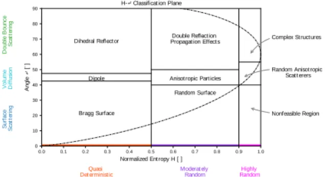
One of the main tasks in the WISDOM data evaluation is the short-term reliable classification and correct localization of subsurface scatterers and layers. The fully polarimetric nature of the WISDOM measurements allows the use of the entropy-alpha decomposition (H-α). This method enables the classification of reconstructed images of the subsurface (obtained by inverse imaging algorithms) with regard to the main scattering mechanisms of geological features present in the image of the subsurface (see Fig. 3).
GPR measurements under laboratory conditions suggest the feasibility and value of the approach for the classification of geological features in the Martian subsurface in the context of WISDOM data
processing and operations (see Fig. 4). It is a fast and reliable tool leveraging the whole amount of information provided by the fully polarimetric WISDOM radar.
0.0 0.1 0.2 0.3 0.4 0.5 0.6 0.7 0.8 0.9 1.0
Normalized Ent ropy H [ ]
0 10 20 30 40 50 60 70 80 90 A n g le ↵ [ ◦] Double Reflection Propagat ion Effect s
Anisot ropic Part icles Random Surface Dihedral Reflector
Dipole
Bragg Surface
Complex St ruct ures
Random Anisot ropic Scat t erers Nonfeasible Region S u rf a c e S c a tt e ri n g V o lu m e D if fu si o n D o u b le B o u n c e S c a tt e ri n g Quasi
Det erminist ic Moderat elyRandom RandomHighly
H-↵ Classificat ion Plane
Figure 3: Entropy-alpha classification plane and scattering mechanisms.
0.0 0.1 0.2 0.3 0.4 0.5 0.6 0.7 0.8 0.9 1.0
Normalized Ent ropy H [ ]
0 10 20 30 40 50 60 70 80 90 A n g le ↵ [ ◦] H-↵Classification Plane Dihedral Sphere
Figure 4: H-α results under realistic laboratory conditions for a buried sphere and dihedral.
Acknowledgements
WISDOM development and this research were supported by funding from the French space agency
CNES and from the German space agency DLR
References
[1] D. Plettemeier, V. Ciarletti, S.-E. Hamran, C. Corbel,P. Cais, W.-S. Benedix, K. Wolf, S. Linke, and S. Roddecke, “Full polarimetric GPR antenna system aboard the ExoMars rover”, in Radar Conference, 2009 IEEE, May 2009, pp. 1–6.
[2] V. Ciarletti, C. Corbel, D. Plettemeier, P. Cais, S. Clifford, and S.-E. Hamran, “WISDOM GPR Designed for Shallow and High-Resolution Sounding of the Martian Subsurface”, Proceedings of the IEEE, vol. 99, no. 5, pp. 824 –836, may 2011.
[3] S. Dorizon, V. Ciarletti, D. Plettemeier, and W.-S. Benedix, “Performance validation of the ExoMars 2018 WISDOM GPR in ice caves, Austria”, Planetary and Space Science, Elsevier, 2016, 120, pp.1-14.