HAL Id: insu-02177135
https://hal-insu.archives-ouvertes.fr/insu-02177135
Submitted on 8 Jul 2019
HAL is a multi-disciplinary open access
archive for the deposit and dissemination of sci-entific research documents, whether they are pub-lished or not. The documents may come from teaching and research institutions in France or abroad, or from public or private research centers.
L’archive ouverte pluridisciplinaire HAL, est destinée au dépôt et à la diffusion de documents scientifiques de niveau recherche, publiés ou non, émanant des établissements d’enseignement et de recherche français ou étrangers, des laboratoires publics ou privés.
EMSO: A Distributed Infrastructure for Addressing
Geohazards and Global Ocean Change
Mairi Best, Paolo Favali, Laura Beranzoli, M. Cannat, N. Cagatay, J.
Dañobeitia, E Delory, H de Stigter, B Ferré, M. Gillooly, et al.
To cite this version:
Mairi Best, Paolo Favali, Laura Beranzoli, M. Cannat, N. Cagatay, et al.. EMSO: A Distributed Infrastructure for Addressing Geohazards and Global Ocean Change. Oceanography, Oceanography Society, 2014, 27 (2), pp.167-169. �10.5670/oceanog.2014.52�. �insu-02177135�
CITATION
Best, M., P. Favali, L. Beranzoli, M. Cannat, N. Cagatay, J.J. Dañobeitia, E. Delory, H. de Stigter, B. Ferré, M. Gillooly, F. Grant, P.O.J. Hall, V. Lykousis, J. Mienert, J.M.A. de Miranda, G. Oaie, V. Radulescu, J.-F. Rolin, H. Ruhl, and C. Waldmann. 2014. EMSO: A distributed infrastructure for addressing geohazards and global ocean change. Oceanography 27(2):167–169,
http://dx.doi.org/10.5670/oceanog.2014.52. DOI
http://dx.doi.org/10.5670/oceanog.2014.52 COPYRIGHT
This article has been published in Oceanography, Volume 27, Number 2, a quarterly journal of The Oceanography Society. Copyright 2014 by The Oceanography Society. All rights reserved. USAGE
Permission is granted to copy this article for use in teaching and research. Republication, systematic reproduction, or collective redistribution of any portion of this article by photocopy machine, reposting, or other means is permitted only with the approval of The Oceanography Society. Send all correspondence to: [email protected] or The Oceanography Society, PO Box 1931, Rockville, MD 20849-1931, USA.
O
ceanography
THE OFFICIAL MAGAZINE OF THE OCEANOGRAPHY SOCIETY
Oceanography
| June 2014 167EMSO
A Distributed Infrastructure for Addressing
Geohazards and Global Ocean Change
The European Multidisciplinary Seafloor and water-column Observatory (EMSO; http://www.emso-eu.org) is addressing the next challenge in Earth-ocean science: how to coordinate data acqui-sition, analysis, archiving, access, and response to geohazards across provincial, national, regional, and international boundaries. Such coordination is needed to optimize the use of current and planned ocean observatory systems to (1) address national and regional public safety concerns about geohazards (e.g., earthquakes, submarine landslides, tsunamis) and (2) permit broadening of their scope toward monitoring environ-mental change on global ocean scales.
SCOPE AND PARTNERS
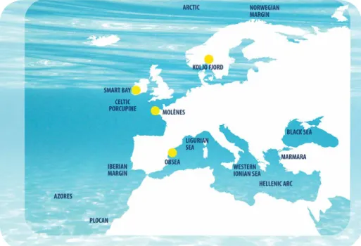
EMSO is a large-scale European Research Distributed Infrastructure of the European Strategy Forum on Research Infrastructures (ESFRI) roadmap. It is composed of fixed-point, seafloor, and water-column observatories with the basic scientific objective of (near)-real-time, long-term monitoring of environmental processes across the geosphere, biosphere, and hydrosphere. This infrastructure is geographically dis-tributed in key sites in European waters, from the Arctic through the Atlantic and Mediterranean to the Black Sea (Figure 1). EMSO ended its Preparatory Phase Project of the EU 7th Framework Programme in 2012 and is now in the Interim Phase, transitioning to the formation of the legal entity for managing the infrastructure: the EMSO
European Research Infrastructure Consortium (herein, EMSO-ERIC). A phased implementation will characterize EMSO site extension, construction, and operation. Countries currently participating in EMSO are Italy, France, Ireland, Spain, Greece, United Kingdom, Portugal, Romania, Norway, Sweden,
Turkey, Germany, and the Netherlands. Participation is open to all (both individual scientists and institutions), and will be coordinated through an association called ESONET-Vi (European Seafloor Observatory NETwork—The Vision), following the extensive scientific community planning
Figure 1. Map of current EMSO nodes. Yellow dots indicate testbeds.
S I D E B A R » S P E C I A L I S S U E O N U N D E R S E A N AT U R A L H A Z A R D S
BY M AIR I BE ST, PAOLO FAVALI , L AUR A BER ANZOLI , M ATHILD E C ANNAT, NA MIK C AGATAY, JUAN JOSE DAÑOBEITIA , ER IC D ELORY, HENKO D E STIG TER , BÉNÉDIC TE FER RÉ , MICK GILLO OLY, FIONA GR ANT, PER O. J . HALL , VA SILIOS LYKOUSIS , JUERGEN MIENERT, JORGE MIGUEL ALBERTO D E MIR ANDA , GHEORGHE OAIE , VL AD R ADULE SCU, JE AN-FR ANÇOIS ROLIN , HENRY RUHL , AND CHR ISTOPH WALDM ANN
contributions of the ESONET-NoE FP7 project (see Priede et al., 2005; Favali et al., 2006, 2010, 2014; Ruhl et al., 2011; Person et al., 2014).
DESIGN AND TECHNOLOGY
The most striking characteristic of obser-vatory design is that it allows addressing interdisciplinary objectives simultane-ously across temporal and spatial scales. Data are collected from the surface ocean through the water column and the benthos to subseafloor. Depending on the application, in situ infrastructures can either be attached to a cable, which provides power and enables data trans-fer, or they can operate as independent, stand-alone benthic and moored instruments. Data, in both cases, can be transmitted in real time either through fiber-optic cables or through cable and acoustic networks that are connected to satellite-linked buoys. Cabled infrastruc-ture provides important benefits such as high power and bandwidth to support real-time data transfer for processing of large data sets (e.g., for bioacoustics and high-definition cameras), for real-time integration with land-based networks (e.g., for seismology), and for rapid geohazard early warning systems.
RESEARCH
EMSO provides power, communica-tions, sensors, and data infrastructure for continuous, high-resolution, (near)-real-time, interactive ocean observations across a truly multi- and
interdisciplinary range of research areas, including biology, geology, chemistry, physics, engineering, and computer science; from polar to tropical environ-ments; and from surface waters down to the abyss. Such coordinated data allow us to pose multivariate questions in space and time, rather than focusing on single data streams (Figure 2).
In addition to generic sensors contributing to the monitoring of environmental change on global ocean scales, questions specific to each site’s environment can be addressed by specific sensor modules set up in varying combinations depending on objectives for the site (Ruhl et al., 2011). For exam-ple, for geohazard early warning capabil-ity, measuring seismic motion, gravcapabil-ity, magnetism, seafloor deformation, sedimentation, pore-water properties, gas hydrates, and fluid dynamics all at once results in a more comprehensive understanding of the system than would more isolated measurements (e.g., Monna et al., 2014; Sgroi et al., 2014, in this issue). Many physical and biological applications require instru-ments throughout the water column for recording high- resolution time-series data over long periods. Depending on the specific application, these data can be drawn from profiling sensor arrays, sensors placed along mooring lines, or even mooring arrays. Such systems can, for example, detect variations in deep ocean currents and in the surface ocean or the bottom boundary layer. These
specialized systems can include the capa-bility to synoptically measure physical parameters such as temperature, salinity, and current velocity, and biogeochemical and ecological parameters such as con-centrations of oxygen, nutrients, chloro-phyll, and pH. Other more specialized biogeochemical systems include sedi-ment traps, pigsedi-ment and hydrocarbon sensors, and in situ mass spectrometers. Systems for marine ecological research include time-lapse and video imaging, active acoustic recording, plankton sampling, holographic plankton imaging, in situ respiration measurements, and in situ molecular and genetic analysis.
DATA
Continuous data are required to document episodic events, such as earthquakes, submarine slides, tsunamis, benthic storms, biological community shifts, pollution, and gas hydrate release. Long-term time series are relevant for monitoring global change. EMSO provides pan-European power, communications, sensors, and data infrastructure for continuous, high-resolution, (near)-real-time, coor-dinated, interactive ocean observations that allow the scientific community to address these challenges. It not only brings together countries and disciplines, but also allows pooling of resources and coordination for assembling harmonized data into a comprehensive regional ocean picture that EMSO will then make available to researchers and stakeholders worldwide on an open access and interoperable basis.
GLOBAL CONTEXT
EMSO is the European counterpart to similar large-scale systems in various stages of development around the world (see Favali et al., 2010): United States (Ocean Observatories Initiative; http://oceanobservatories. org), Canada (Ocean Networks
Mairi Best ([email protected]) is Ocean Observatory Consultant, Paolo Favali is Coordinator, and Laura Beranzoli is Program Manager, all at the European
Multidisciplinary Seafloor and water column Observatory (EMSO) Interim Office, Rome, Italy. Mathilde Cannat (France), Namik Cagatay (Turkey), Juan Jose Dañobeitia (Spain), Eric Delory (Spain), Henko de Stigter (The Netherlands), Bénédicte Ferré (Norway), Mick Gillooly (Ireland), Fiona Grant (Ireland), Per O.J. Hall (Sweden), Vasilios Lykousis
(Greece), Juergen Mienert (Norway), Jorge Miguel Alberto de Miranda (Portugal), Gheorghe Oaie (Romania), Vlad Radulescu (Romania), Jean-François Rolin
(France), Henry Ruhl (UK), and Christoph Waldmann (Germany) are all
Oceanography
| June 2014 169Canada; http://oceannetworks.ca), Japan (Dense Oceanfloor Network System for Earthquakes and Tsunamis; http://jamstec.go.jp/donet), China (East China Sea Seafloor Observation System), Australia (Integrated Marine Observing System; http://imos.org.au), and Taiwan (Marine Cable Hosted Observatory; http://scweb.cwb.gov.tw/macho-web). Compared to above-mentioned national initiatives, EMSO has the challenge of dealing with harmonizing the different research interests and governmental regulations of several European nations. The experience gained within EMSO in transcending national boundaries provides valuable experience for further integration of the various ocean observation systems around the world into a single powerful integrated global ocean network.
ACKNOWLEDGMENTS
EMSO is built on the progress made through over 23 European marine observation projects through many decades. In particular, its foundation is based on the work of hundreds of people in ESONET Concerted Action (FP5) from 2002 to 2004, ESONIM (European Seafloor Observatories Implementation Model) (FP6) from 2004 to 2007, ESONET-NoE (FP6) from 2007 to 2011, and EMSO-Preparatory Phase (FP7) from 2008–2012.
REFERENCES
Auffret, Y., J Blandin, D. Choqueuse, C. Compère, L. Delauney, J.-F. Drogou, P. Jegou, C. Leveque, J.-F. Rolin, and P. Valdy. 2014. Long-term sub-sea observatories: Comparison of architectures and solutions for infrastructure design, interfaces, materials, sensor protection and deployment operations. Chapter 8 in
Seafloor Observatories: A New Vision of the
Figure 2. Temporal and spatial scales of ocean processes. From Ruhl et al. (2011)
Earth from the Abyss. P. Favali, L. Beranzoli, and
A. De Santis, eds, Series: Springer Praxis Books, Subseries: Geophysical Sciences.
Favali, P., L. Beranzoli, G. D’Anna, F. Gasparoni, J. Marvaldi, G. Clauss, H.W. Gerber, M. Nicot, M.P. Marani, F. Gamberi, C. Millot, and E.R. Flueh. 2006. A fleet of multiparameter observatories for geophysical and environ-mental monitoring at seafloor. Annals of
Geophysics 49:659–680.
Favali, P., R. Person, C.R. Barnes, Y. Kaneda, J.R. Delaney, and S.-K. Hsu. 2010. Seafloor observatory science. In: OceanObs’09: Sustained
Ocean. Observations and Information for
Society conference 2, Venice, Italy, September 21–25, 2009. J. Hall, D.E. Harrison, and D. Stammer, eds, ESA Publication WPP-306. Favali, P., L. Beranzoli, M. Best, and EMSO
Partners. 2014. EMSO—The European Multidisciplinary Seafloor and Water-Column Observatory: Transition from planning to implementation. Paper presented at the IEEE Oceans’14 Conference, April 2014, Taipei. Monna, S., G. Falcone, L. Beranzoli, F. Chierici,
G. Cianchini, M. De Caro, A. De Santis, D. Embriaco, F. Frugoni, G. Marinaro, and oth-ers. 2014. Underwater geophysical monitoring for European Multidisciplinary Seafloor and water-column Observatories. Journal of Marine
Systems 130:12–30, http://dx.doi.org/10.1016/
j.jmarsys.2013.09.010.
Person, R., P. Favali, H.A. Ruhl, L. Beranzoli, J.-F. Rolin, C. Waldmann, R. Huber, Y. Auffret, M.N. Çağatay, M. Cannat, and others. 2014. From ESONET multidisciplinary scientific community to EMSO novel European research infrastructure for ocean observation. Chapter 20 in Seafloor Observatories: A New Vision of the
Earth from the Abyss. P. Favali, L. Beranzoli, and
A. De Santis, eds, Series: Springer Praxis Books, Subseries: Geophysical Sciences.
Priede, I.G., R. Person, and P. Favali. 2005. European seafloor observatory network.
Sea Technology 46:45–49.
Ruhl, H.A., M. André, L. Beranzoli, M.N. Cağatay, A. Colaco, M. Cannat, J.J. Dañobeitia, P. Favali, L. Géli, M. Gillooly, and others. 2011. Societal need for improved understanding of climate change, anthropogenic impacts, and geo-hazard warning drive development of ocean observato-ries in European Seas. Progress in Oceanography 91:1–33, http://dx.doi.org/10.1016/j.
pocean.2011.05.001.
Sgroi, T., S. Monna, D. Embriaco, G. Giovanetti, G. Marinaro, and P. Favali. 2014.
Geohazards in the western Ionian Sea: Insights from non-earthquake signals recorded by the NEMO-SN1 seafloor observatory. Oceanography 27(2):154–166, http://dx.doi.org/10.5670/oceanog.2014.51.