HAL Id: inria-00070528
https://hal.inria.fr/inria-00070528
Submitted on 19 May 2006
HAL is a multi-disciplinary open access
L’archive ouverte pluridisciplinaire HAL, est
Virtual Environment for Architecture and Urban
Planning
George Drettakis, Maria Roussou, Manuel Asselot, Alex Reche, Alexandre
Olivier, Nicolas Tsingos, Franco Tecchia
To cite this version:
George Drettakis, Maria Roussou, Manuel Asselot, Alex Reche, Alexandre Olivier, et al.. Participatory
Design and Evaluation of a Real-World Virtual Environment for Architecture and Urban Planning.
[Research Report] RR-5479, INRIA. 2006, pp.21. �inria-00070528�
ISRN INRIA/RR--5479--FR+ENG
a p p o r t
d e r e c h e r c h e
Thème COG
Participatory Design and Evaluation of a Real-World
Virtual Environment for Architecture and Urban
Planning
George Drettakis, REVES — Maria Roussou, UCL — Manuel Asselot, REVES — Alex
Reche, REVES/CSTB — Alexandre Olivier,REVES — Nicolas Tsingos,REVES — Franco
Tecchia,PERCRO
N° 5479
George Drettakis, REVES
∗, Maria Roussou, UCL
†, Manuel Asselot, REVES ,
Alex Reche, REVES/CSTB
‡, Alexandre Olivier,REVES , Nicolas
Tsingos,REVES , Franco Tecchia,PERCRO
§Thème COG — Systèmes cognitifs Projets REVES
Rapport de recherche n° 5479 — January 2005 — 21 pages
Abstract: In this report we present a participatory design approach to the development of a VE,
with an iterative, user-informed process throughout the entire design and development cycle. A pre-liminary survey was first undertaken with end-users, i.e., architects, chief engineers and decision makers of a real-world urban planning project, followed by a study of the traditional workflow em-ployed. We then determined the elements required to make the VE useful in the real-world setting, choosing appropriate elements (image-based textures for facades, realistic vegetation, shadows, 3D sound and crowds) to develop a rich and audiovisually realistic VE. Our participatory design ap-proach guided the development of an appropriate interface and an evaluation methodology to test the overall usability of the system. The VE was evaluated both in the laboratory and in the users’ natural work environments. The results suggest that participatory design can help ensure that the VE will meet the practical needs of its end-users; that appropriately chosen multiple views of the scene are useful in urban planning, and that the realism enhancements introduced increase the effectiveness of VEs for the chosen context.
Key-words: Virtual Reality, Human Computer Interaction, Evaluation of Virtual Reality
∗e-mail: George.Drettakis@inria.fr
†University Colledge London, e-mail: M.Roussou@cs.ucl.ac.uk ‡Also affiliated with CSTB
Résumé : Dans ce rapport nous présentons une approche de design participatif au développement
d’un Environnement Virtuel, à l’aide d’un processus itératif informé par l’utilisateur tout au long du cycle de conception et développement. Une première enquête a été faite avec les utilisateurs finaux, c’est à dire les architectes, ingénieurs et décideurs d’un projet d’urbanisme réel. Ensuite, nous avons étudié en détail les étapes traditionnelles de travail. Nous avons par la suite déterminé les éléments nécessaires pour rendre l’environnement virtuel utile dans un contexte de projet réel, en choisissant une série d’éléments (rendu à base d’images pour les textures, végétation réaliste, ombres, son 3D et simulation de foules) pour développer un environnement virtuel audiovisuel, réaliste et riche. Notre approche de design participatif, a guidé le développement d’une interface appropriée et une méthodologie d’évaluation pour tester la facilité dutilisation du système. L’environnement virtuel a été évalué à la fois dans des conditions de laboratoire et dans l’environnement de travail habituel des utilisateurs. Les résultats de notre évaluation suggèrent que l’approche de design avec participation des utilisateurs finaux peut nous aider à assurer que l’environnement virtuel satisfera leurs besoins pratiques; que les vue multiples de la scène sont utiles pour l’urbanisme et que le réalisme accru introduit par notre système augmente l’efficacité de l’environnement virtuel dans le contexte choisi.
1
Introduction
The majority of Virtual Reality (VR) applications developed today are products of research that are either prototypes created within very specific contexts or are used for presentation purposes. Despite the promise and the development activity of over two decades, there has been a considerable lack of real-world applications. The issues regarding the deployment of VR in everyday work contexts have been discussed many times and continue to revolve around the familiar practical difficulties: setting up special and costly hardware within facilities that are not easily transportable, requiring special teams of developers and maintenance staff, but also providing the high-level tools that will support users in their complex tasks [12] and can succeed in establishing a collaborative VR work environment amongst individuals of different disciplines [11].
Experienced practitioners in the field of VR have indicated that to work effectively in a virtual environment (VE), the application content must include the ability to access or change environmen-tal/system/meta parameters, create and manipulate particular objects, perform analyses, and export changes to permanent storage [18]. While the current state of VE development has advanced its techniques to support these tasks, rarely does one find complete VEs that achieve both a high-quality photorealistic real-time environment and the level of interactivity required to carry out sufficiently complex real-world tasks.
Our goal is to create a VE infrastructure supporting both audio and visual realism and a high level of interactivity, and to situate and evaluate its utility in an appropriate real world application context. We chose the domains of architectural design and urban planning (UP), where realism and interactivity are inherent requirements of the work process. A detailed user requirements analysis with architects and urban planners [17] confirmed the suitability of our choice and led to a detailed study of the existing workflow in these domains. A key element throughout this work has been our close collaboration throughout the entire project with the end-users of a real-world urban planning project, involving the redesign of public spaces as part of the construction of a new Tramway in the city of Nice in France.
Following our initial user needs analysis that guided our choices and design, we proceeded with the development of a complete VE that was continuously informed by the participation of the end-users. Development and evaluation advanced together in order to determine the elements required to make the VE useful in the context of the real-world project we were fortunate to connect to. The resulting VE provides a design and brainstorming tool for architects and decision makers, that also serves as a consensus building tool and as an impressive means for presentation of the project.
In addition to the participatory design approach, our work includes in-depth formative and pre-liminary summative evaluation. Evaluation was performed based on observation, questionnaires and interviews with architects that took place both in a controlled lab experiment setting as well as in the “field”, i.e. the actual work environment where the VE was used in decision-making meetings of the urban planning project.
In summary, we present a participatory design approach to the design of a VE, with an iterative, user-informed process throughout the entire design and development cycle. A preliminary survey was undertaken with end-users (architects, chief engineers and decision makers), in the context of the real-world project, followed by a study of the traditional workflow employed. After this first phase,
we determined the elements required to make the VE useful in the real-world setting. As a result, we developed a rich and audiovisually realistic VE, allowing us to test the significance of added realism, in particular images-based textures for facades, vegetation, 3D sound, shadows and crowds. Our participatory design approach guided the development of an appropriate interface, as well as an evaluation methodology to test the overall usability of the system. The VE was evaluated both in the laboratory and in the users’ natural work environments. The results, as discussed later, suggest that an iterative process of design and evaluation, if adopted early on in the project’s development, can help ensure that the VE will meet the practical needs of its end-users. The evaluation also shows that appropriately chosen multiple views of the scene are useful in urban planning, and that the realism enhancements introduced increase the effectiveness of VEs for urban planning.
2
Related Work
Virtual reality development for architectural design and urban planning applications can be roughly grouped into two categories: applications that display detailed 3D CAD models of architectural spaces/structures and rapid prototyping systems.
In the first case, the challenge has been to visualize large data sets in as photorealistic a fashion as possible. These environments are mostly used for presentation, recreation, and educational purposes (e.g. review of architecture before it is actually built, cultural heritage reconstructions, 3D entertain-ment rides, etc.) where complex 3D spaces are constructed so they can be explored in walk-throughs [2, 8]. The majority of these projects allow for little to no interactivity beyond the user’s ability to freely navigate about the environment.
On the other hand, the virtual prototyping environments allow immersive VR to be used in ear-lier phases of a design process and are thus designed to incorporate a higher level of interactivity and object manipulability. In most cases, these capabilities are implemented at the expense of visual realism, as they have been developed by computer scientists in order to further advance research in VR tools. Furthermore, most of these environments support only trivial user tasks and thus can-not be used in real-world situations. Nevertheless, many interesting ideas have been introduced by architectural prototyping projects that we can draw from. The CALVIN project [9], for example, in-troduced the idea of different perspectives, the mortal (ground-level) viewpoint and the deity (global above-ground) viewpoint, either of which users can assume to interact collaboratively in designing a space in VR.
The core idea from the beginning of our project has been to combine the strengths of the above two categories of virtual environments, namely to achieve the realistic visualization/auralization of a large space coupled with the ability to use it early on in the design process as an interactive work tool. Essentially, our goal is to create a virtual space that can complement and enrich people’s day-to-day work practice in a useful and meaningful way. In order to achieve this we adopted the design approach described next.
3
Design
The basic premise of our VE design approach has been to engage architects, designers and decision makers from the first steps of the design. Putting such a user-centered approach into practice requires collecting and analyzing as much information about our users as possible, through a detailed user requirements process [17] and a deep understanding of how they work.
The city of Nice and the Greater Nice-Cote d’Azur Urban Community (CANCA) recently de-cided to build a Tramway. The project involves 8 km of rail in the most dense parts of the city, requiring the re-design of several open spaces such as the main city squares, “Place Garibaldi” and “Place Massena”. We established a working relationship with the officials and the company of ar-chitects in charge of the project. Initially, we presented a simple VE prototype of a section of “Place Massena" to the “Mission Tramway”, the organization in charge of the overall project (see images in [16]).
The result of this contact led to a closer collaboration with the architects on the re-design of “Place Garibaldi”, and enabled us to gain access to all the project data. The architectural design of this square was of major importance, since the “Place Garibaldi” is a historic landmark and, according to many “the most beautiful square of the city”. As such, many stakeholders participated in the decision making process: local elected officials (principally the mayor), the officials of the city council in charge of open spaces and public works, as well as higher state authorities at a national level who generally have a definitive say in any modification of a historical space. There is also a public consultation which occurred at the beginning and continues throughout the design process.
Our collaboration was founded on the principle of mutual benefit. We were interested in studying and understanding the workflow to allow us to design novel VE tools that combine realism and interactivity, and to apply them in a real-world setting. The architects and decision makers of the Mission Tramway were interested in using the resulting interactive VE as an aid in decision making and brainstorming, as well as a presentation tool.
3.1
Study of End-User Design Workflow
After multiple discussions with architects, and following them in their work, we made a number of observations on the workflow of the architectural design process in this particular project and on the way that decisions were made. Architects in this project work in a very constrained manner, since the decisions made are ultimately political and several different stakeholders intervene in the process.
For the re-design of the square, several different concepts were proposed, with significant vari-ations: A “Place d’armes” (military, “stone-only” square) in which no additional vegetation was to be allowed; A modern design, with additional vegetation; A more traditional design, with additional vegetation. The architects had a complex balancing act to follow. According to our interviews, they spent a while debating in numerous meetings the different merits of each choice, without advancing much.
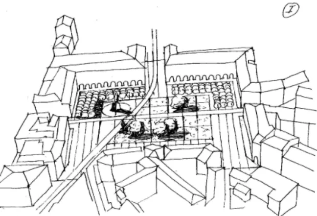
The initial design process took place mainly between the municipal administration and the ar-chitects. At this stage, architects used simple fast “sketches” to communicate their ideas and the different options. Examples of these “fast” designs are shown in Fig. 1.
Figure 1: Fast architectural sketches of Place Garibaldi.
Figure 2: Perspectives can be used for an overall view of the design.
A 2D plan drawing was used for initial designs at the first stage of conception. As we can see, several different designs were proposed, including a compromise so that the basic “minimal vegetation” requirement of one proposal was being met, while adding some vegetation; however, the proposed vegetation is limited to small trees in pots rather than planted trees.
This is the stage in which all options are truly open, and we can see that architects work with approximate hand-drawn sketches, mostly based on a 2D plan projection, but sometimes using per-spective to illustrate an overall concept (Fig. 2).
Figure 3: More involved perspectives can be used to illustrate specific details in the scene.
Using this initial stage where they iterate over many experimental sketches on paper, the archi-tects get an overall feel for the design, and sometimes will draw details of part of the site to capture the essence of specific elements (Figure 3).
The next stage is the production of photo-montages which are shown to the decision makers and the elected officials. These montages are used to achieve agreement by the different parties, and after this process, the design is essentially “fixed”.
Following our observations of the workflow, we decided that we will not address the initial “sketch” phase, since this would be a research topic on its own requiring sketch-based interfaces, an active research area which, however, is not yet mature enough for use with professional users.
3.2
Development of the Realistic VE
As mentioned in the introduction, one important reason which hinders the use of VEs in real world projects is the lack of sufficient visual realism. In the case of urban planning where the goal is the presentation and review of different concepts for outdoor spaces, visual realism is necessary.
Such spaces include existing elements which do not change (such as building facades, etc.), but also the elements of the new planned space. To be useful as a design and presentation aid, a convincing level of realism needs to be achieved in the VE, both for the representation of the existing buildings and for the new elements that will be added.
The quest for realism has been a long-standing goal of computer graphics research since its inception. Realism for virtual environments touches all parts of a given scene and its display. In the context of UP, this includes high-quality geometry and textures for buildings, high-quality models and display for vegetation, accurate and consistent lighting and relighting with shadows, vehicles and traffic simulation, population with individual and crowd animation with simulated behavior, accurate 3D sound rendering etc. To be included in a VE, the display/rendering of all of the above need to be sufficiently fast to still result in acceptable frame rates.
Clearly, addressing all of the above would be an overwhelming task, and for some of the en-hancements, efficient solutions simply do not exist (for example relighting, or large-scale simulated behavior). In our system, we have chosen to concentrate of a set of enhancements that emerged as important through our initial user needs analysis and for which we were able to provide efficient and appropriate solutions.
In particular, our system, which has been presented in [5, 16], provides solutions for photo-graphic capture of existing buildings, shadows, display of vegetation, 3D sound and crowds. Specif-ically, we have used novel image-based reconstruction techniques to provide accurate capture of buildings at a medium scale (i.e., the size of a 200m x 200m square in a city), including high-quality textures and moderately complex geometry.
We have adapted perspective shadow maps [19] for use in a VE system, allowing the display of high-quality sharp shadows in real time. Shadows in outdoor scenes are of primary importance, allowing better perception of spatial relationships, appreciation of shade and sunlight as well as helping users perform more accurate manipulation of objects in space.
Our solution for display of vegetation is based on a mixed approach using point-based rendering and polygons [4], which we adapted to our VE display system. Trees and vegetation in general are notoriously hard to deal with using traditional level-of-detail mechanisms, since most methods work will on connected meshes. Point-based approaches work well in these cases; in the scenes we used, each tree has approximately 80,000 polygons at full resolution, and we display more than 70 trees at times. This would result in close to 6 million polygons, posing an unacceptable load on the display system. The solution we use allows fluid display of trees, while maintaining high-quality, polygon-based display when the user zooms in.
We have also developed a novel solution for rendering of high-quality spatialized 3D sound [24], which allows spatialization of a large number (˜ 300) of sound sources. This permits the introduction of truly spatialized sound in complex outdoor environments such as those required for urban planning.
Finally, we have added simple crowd simulation to our environments [23, 22] allowing the rapid display of a large number of humans, using rule-based flow simulation [21]. The addition of humans to outdoor scenes is important, since it adds life and motion to the environment. Humans are also the most common measure of scale used by architects to communicate the dimensions of a design (see figure used to communicate scale in Fig. 4).
All of these enhancements are included in a complete system, based on the XP [14] software layer, built upon PerformerT Mand CAVElibT M. All the enhancements described above were added
as new classes in the extensible core library; their parameters are all controllable by scripts which can be edited by the artists and programmers developing the VE.
3.3
Design of the VE Interface
The design of our interface was inspired by the workflow described in Sect. 3.1. The initial idea was to preserve the “top view” corresponding to the familiar existing workflow (Fig. 5). We also have a ground-level “perspective view” (Fig. 6), corresponding to that used in the photo-montage. We have introduced an intermediate “balcony view”, shown in Fig. 7, where the viewer is presented with a view as if she were standing on the balcony of one of the surrounding buildings in the square. This view corresponds to the higher level sketch perspectives that the architects sometimes use in the initial stages of their design (see Fig. 2).
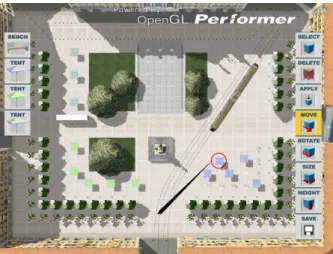
Figure 5: The top view of the VE is displayed with two sets of menus for the insertion and manip-ulation of dynamic objects. A small umbrella (circled in red) is attached to the end of the wand and can be moved and positioned anywhere in the Square.
The central functionality of the interface allows the user to manipulate dynamic elements in the scene, such as benches, umbrellas or trees in the top view, inspired by the iterative sketches process (Fig. 1). In our system the user has the ability to freely switch between top, perspective and balcony view at any time and perform manipulations in all three.
Given our choice of concentrating on the second phase of design, when many of the basic choices have been made, the top view contains the basic layout of trees with their grass-filled container regions, the statue and fountain. Since manipulation occurs mainly in this view, the user is presented with sets of menus on either side of the top view (Fig. 5). Menus are only present in the top view.
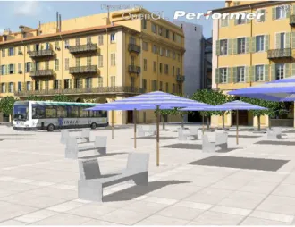
Figure 6: Simulator snapshot of the perspective view. Note the realism of the captured facades of the buildings, shadows and point-based rendering of trees.
The left hand side contains the “insert” menus, in this case options for inserting the 3D models of different benches and umbrellas. The right hand side contains the “operations” on the inserted items, such as “resize”, “resize width”, “move”, “rotate”, “select” and “apply”. Motion and placement are snapped to a grid in the scene.
Our immersive display interface includes a tracked game-controller, with 12 buttons and a joy-stick, which operates similarly to a “laser pointer”. The 3D model of a rod “extends” the device in the virtual space. Four of the buttons are used. One is the “action” button used for selection of the menu items and for all other selection/deletion/manipulation actions. The remaining three buttons are mapped to the top, perspective and balcony views.
In top view, the user can select an object from the menus using the wand, which places her directly into “insert” mode. When an object icon is selected, a miniature object (umbrella or bench) is attached to the end of the wand and inserted onto the ground of the Square (Fig. 5). Each time the user clicks on the action button, an object is placed at the current location. During this time the user can switch to the other views. The user can then select one of the “move” “resize” or “rotate” menus to perform the equivalent action to the chosen object. Manipulation of quantities is performed relative to this fixed point (i.e., distance from the point of intersection of the wand at the time of the first click). Once the user has designed one of the objects to be placed, she can apply the design to a set of objects via the select and apply menus.
Figure 7: Simulator snapshot of the balcony view of the Place Garibaldi, showing the Tramway passing through the square. The user can move around freely in all views, including the balcony view.
At any time during the design session the user can move around in the environment and evaluate the result of her work either in perspective view or by moving to the “balcony view”, allowing a more “overall” view of the current state of the design.
4
Evaluation Methodology
Our evaluation methodology draws from the structured framework proposed by [7] [1] for the design and evaluation of user activity in VEs. This includes the combination of user needs analysis, user task scenarios, usability evaluation and formative evaluation, and preliminary summative evaluation. The user needs analysis was carried out at the very beginning of the project and led to the defini-tion of the user task scenarios that were used in the evaluadefini-tion sessions. Usability evaluadefini-tion forms a central tenet of our evaluation methodology, as it involves observing the users of the VE in order to determine if the VE aids or hinders them in reaching their intended goals. The International Orga-nization for Standardization defines Usability (ISO 9241-11:1998) as “the effectiveness, efficiency and satisfaction with which specified users can achieve specified goals in particular environments”. Similarly, Nielsen identifies learnability, efficiency, memorability (retention), accuracy (errors), and satisfaction as the most common attributes of usability, as well as issues concerning user interface and interaction [13].
Usability evaluation is usually performed by expert users who follow a set of heuristics for the assessment of a system, such as the ones identified by Nielsen. However, since we adopted a participatory design approach, which means working in real-world application conditions directly
with end-users implicated in a real project, the representative users of our environment (the architects of the real-world project) served as both usability experts and typical end-users.
We have chosen to limit our testing to a small number of users and follow an in-depth qualitative approach. One of the reasons for this, is the obvious difficulty in evaluations of real-world situations, i.e., getting busy, highly qualified professionals to agree in participating in experimentation, which requires a significant investment in time. Other reasons include the highly experimental nature of the prototypes and the use of innovative and relatively inaccessible equipment (tracked immersive VR displays).
We believe that for this project, case studies, where small groups of users are studied in depth, is more useful for gaining insights into the effectiveness and efficiency of our system, and comes as a natural continuation to the participatory design process that preceded the evaluation. Usability testing was conducted in the controlled setting of our laboratory. The users were asked to carry out a set of predefined tasks. The tasks used for the usability evaluation accurately represented the intended actual use of the application and occurred within a realistic scenario.
The methods used in our evaluation included direct observation, a post-experiment questionnaire and post-experiment interviews.
Direct observation. Users performed the various tasks whilst being observed by a facilitator.
Users were encouraged to use a think-aloud protocol [6] to explain what they are doing, to ask questions and to give information. The facilitator used an interactive style, asking users to expand upon comments and activities. Sessions were also videotaped for further analysis.
Questionnaire. A usability questionnaire was developed to identify the user’s perception of the
effectiveness and efficiency of the system and their level of satisfaction with the interaction. Our questionnaire was constructed by merging a number of standard user satisfaction questionnaires, such as the approaches provided by Perlman [15] and others [3]. The questionnaires include ques-tions that require answers on a 1-7 Likert scale [10].
Interviews. An informal interview following the experience was used to help identify the various
issues that occurred during the experience and that could not be captured by the questionnaire. The interview was particularly important for understanding the issues involved in the in situ usage of the system, where the use of a questionnaire does not make sense.
5
Evaluation
As mentioned previously, we performed evaluation of the VE both in a controlled laboratory context and in the natural work environment of the various individuals involved in the real urban planning project. In the next sections we describe both these forms of evaluation, controlled and situated.
5.1
Experiment
The goal of the controlled experiments was to evaluate the combined effect of realism and inter-activity for a real-world urban planning task, as well as the system’s usability. As mentioned in Section 3.2, the realism enhancements we tested were: high-quality shadows, realistic point-based vegetation, 3D sound and crowds. The way this was done was by including three different levels
of realistic features into the same scene, one where visual enhancements and sound were included, one with no enhancements and one with audio/visual enhancements and simulated population. The experiment was run with three of the collaborating professional architects, all directly implicated in the real Nice Tramway project, and specifically in the design of the new Garibaldi square. Prior to the sessions with the architects, we ran pilot studies with engineers who had no previous VR or computer graphics experience.
We include two accompanying videos (AVI files), one with a selection of filmed user sessions, and one with screen capture of our simulator showing the VE and the interaction used. The reader is encouraged to view these to better understand the experiment and its evaluation.
Procedure
The experiment took place on a Barco Baron workbench with the tracked game controller operating as described previously (Fig. 8). Each subject was head-tracked and wore active stereo glasses.
Figure 8: View of a user of the system on the workbench.
The overall goal, as defined by the users themselves from the beginning of the project, was to “create, define the appropriate size and position of design elements (different umbrellas and benches), and to evaluate the occupation of space and overall aesthetic effect on the new design of the square".
The main experiment was preceded by a simple training environment in order to allow the user to learn the interface.
Training Environment
The training environment contains the same interface as the main experiment, but the VE is a sim-plified version of the scene (a short sequence of this is shown in the video). The menus described in Sect. 3.3 (Fig. 5) are all present in the training scene, but the scene consists simply of a plane
representing the ground. This results in an uncluttered, simple VE, which allows the user to learn the interface more easily. In addition, this VE has no latency problems, since it contains none of the realism VE enhancements we have added.
The training session starts with the facilitator explaining the overall goal of the experiment, and then introducing the interface. The facilitator then performs all the tasks (insert an umbrella, move, resize and rotate an umbrella, select and apply). The meaning and use of the top, perspective and balcony views are all explained and presented.
The user is then guided through these tasks, and asked to repeat them until she feels comfortable with the interface, typically for around 10-15 minutes.
Main Experiment
The main experiment VE included the entire environment of the new design of Place Garibaldi, with the same interface as the training session (Fig. 5). The task was to place, size and arrange the umbrellas and stone benches in regions close to the orange trees. The user was asked to first position the elements, then determine the size (height and size) of the umbrellas and the placement of the benches, and finally to evaluate the “presence” and “occupation” of the square.
To evaluate the effect of realism, three levels of realistic VE enhancements were encoded into the same experiment. To achieve this we assigned a different colored umbrella to be placed in each of the three corners of the scene as seen in the top view (see Fig. 5, lower right, lower left and top left corners). The users were asked to design and place umbrellas and benches for each one of the corners/color codes in sequence, completing the design for each corner/color color before proceeding to the next. Thus the design for each corner was implicitly a separate sub-task, encoded by umbrella color. Each sub-task was performed with a different level of realism. In particular:
• The task in the lower right corner (blue umbrellas) was displayed with shadows, point-based trees and sound.
• The task in the lower left corner (green umbrellas), used “standard” VR quality (i.e., no shad-ows, no sound, billboard trees, and no crowds).
• The task in the upper left corner (mixed-color umbrellas), was displayed with all enhance-ments (shadows, point-based trees, sound and crowds).
Each user was presented with the top-view at the outset, and was told to create and place umbrel-las and benches, starting with the lower right corner. Thus the user started with blue umbrelumbrel-las. The user would insert a primitive (umbrella or bench), and typically position it in top-view. The users were reminded that they could switch freely between views. In a typical session, the user would place a set of umbrellas, either aligned or not, to populate the space. They would then switch to perspective view to correct or adjust placement, and to resize the width and height of the umbrellas. Balcony view was often used to judge the design.
The order in which the levels of realism were tested is important; we chose display enhancements first, no-enhancements and all enhancements with crowds, in that order, to avoid an implicit ranking
elements, and we attempted to identify their relative importance in the questionnaire. Sometimes the users did observe the differences (for example shadows or not etc.), but the facilitator tried to insist that the user concentrate on the task.
5.2
Field Deployment of the System
In addition to the controlled lab experiments, the system has been used at several different occasions in the context of the real project. This was part of the agreement, in which the authorities provided us access to the architects and the data in exchange for their use of our system.
We visited the authorities and the architectural offices at several occasions and report here only the most significant meetings with the official project working group in charge of the design of outdoor spaces. One of these meetings concerned the discussion of a planned proposal for the choice of the type of trees to be used in the square. The choices included either the 3 meter-high orange trees or the 8-meter high oak (see Fig. 9). As the meeting took place at the Nice City Hall, our VE tool was presented on a simulator running on a laptop and using a portable projector with a stereo loud-speaker based sound system and the standard gamepad-based navigation input.
Figure 9: Snapshots of the VEs used in the discussion session with the architects. Left, the “Orange tree” solution; right, the “oak tree” solution.
The working group was comprised of 3 high-ranking city officials, in charge of public spaces and urban planning, 3-4 city middle-level managers who were mainly architects concerned with the overall view of the project, 2 officials from the Mission Tramway, and the architect in charge of the overall project.
The functionality of the tool, including all the realism features (image-based captured buildings, shadows, billboard-based vegetation, 3D sound and crowds) and the top, balcony and perspective views were presented, along with the other system capabilities such as the ability to freely move around in the virtual square with the Tramway, bus and crowds. The two scenarios (orange trees and oak trees) were mapped onto two different buttons on the handheld device. Once the demonstration of the tool was completed, the members of the working group took over, exploring the different views and locations provided for the virtual square and making different choices. They chose one or another type of tree in different places in the square in order to test spatial relationships, the placement of objects, but also the different effect of shadows etc.
Another example of field deployment involved the use of the full VE system (tracked stereo-vision workbench) for a brainstorming session. Two of the main architects and the designer of the project participated in this session and used the system as an opportunity to discuss issues concerning the design of the square, most notably the choice of trees and ground elements (see accompanying video).
6
Evaluation Results and Discussion
To evaluate the laboratory experiment, we used direct observation, a questionnaire and interviews. In the in situ evaluation, the use of a questionnaire is inappropriate, thus limiting evaluation to observation and interviews.
6.1
Observations from the laboratory experiments
After completing the experiment, each of the three architects was asked to complete the questionnaire and participated in the post-experiment interview that followed. We studied the videotaped sessions in order to better reflect on the important issues and difficulties that were expressed by the users during their interaction with the system.
We classify our observations by learnability and ease of use, effectiveness and efficiency, user satisfaction, VE/interface features and realism.
In terms of learnability and ease of use, all participants ranked the system as easy to learn (6 or 7 on the Likert scale) and stated that they were able to use the tool without difficulty. We were particularly pleased with this result, since 2 out of the 3 subjects have no experience with interactive 3D systems or video games.
In terms of effectiveness and efficiency, there was a uniform approval (6 or 7 on the Likert scale) of the utility of the tool and the fact that the system would improve productivity in the workplace. The top view, although familiar, was judged moderately useful (3-5 on the Likert scale). From ob-serving the videos and the interviews it became clear that the precision was insufficient. In retrospect this was to be expected, since the distance from the object being manipulated is too large. Clearly, the best solution to this is a mixed 2D-3D interface, where a “pen-like" interface could be used to directly place objects onto the top-view, as is currently done in existing CAD tools. The need to have the same interface as CAD tools for these tasks was explicitly mentioned by one user. Subject 2 clearly stated that the perception of ambience and scale were extremely useful and important for an architect in the evaluation of an urban planning project, and found that the tool had great potential for brainstorming and interactively trying out different alternatives.
In terms of satisfaction, all users stated both in the questionnaire and in the interviews that they liked the tool. The only other observation (only made by Subject 1) was that given a choice between latency and realism it is clearly preferable to have low-latency and less-realistic display. In the case of the first subject, the parameters for point-based rendering were incorrectly set, and this made manipulation in the trees difficult. This was the reason for this comment. For Subjects 2 and 3 this problem was corrected. Subject 1 also stated that one of the main values of the system was that it removes the “break” which exists between traditional 3D CAD systems and the resulting design.
In terms of VE interface features, the balcony view was used extensively and was greatly appre-ciated by all three participants (see video). All users agreed that this was a particularly useful view of the environment, and that it helped in their judgement of the resulting design, but also during the design. In the questionnaire and the interview Subject 1 pointed out that it would be nice to have the menus present even in the other views (perspective and balcony); the reason this had not been implemented was simply a restriction in programming complexity.
We made several important observations concerning realism. The realism offerred by image-based facade textures and point-image-based vegetation were identified as being important, allowing users to better understand the final effect of the placement of trees on the overall design. The ability to have the true high-quality 3D leaves when zooming in was singled out as being important. However, when explicitly asked in the questionnaire about the differences in realism between the different col-ored tent sessions, the differences between billboards and point-based trees or the presence/absence of shadows did not show up in the questionnaire ranking. However, in the interviews the users re-sponded that they were concentrating on the task and when questioned further, and all identified the importance of shadows, for placement and sense of scale, but also in terms of appreciation of shadow/sun coverage in the square.
The presence of human figures was judged central, in particular as a marker of scale. As men-tioned before, human figures are used in traditional drawings in this manner (Fig. 3). However, the specific representation used, which is based on low-resolution billboards, was judged insufficient.
The inclusion of spatialized 3D sound was judged as very important to evaluate the overall am-bience and atmosphere created by a certain design, in the presence of fountains, the tramway and buses. This was the one item of realism whose presence/absence was noticed by 2 out of 3 partici-pants.
6.2
Observations from field deployment
In the meeting at the Nice City Hall the dynamics of the working group session were very interesting. The group was large (more than ten people counting ourselves), and thus it was difficult to follow the power relationships which were occurring. In the beginning of the presentation, people expressed themselves quite freely and several interesting questions became apparent. Later in the meeting the hierarchical relationships among the participants became more evident, and those who report directly to the elected officials tended to dominate the discussion.
The first interesting observation was that several people at the meeting considered the representa-tion to be too realistic and thus judged it to be inappropriate for public display. One reason advanced for this observation was that people would believe that this would be the exact design thus removing all freedom for the realisation of the final project; with drawings people are more aware of the level of abstraction of the design. Nonetheless, the group considered that this was an excellent tool to help with decision-making, and that with appropriate preparation could be used when showing the design to the elected officials. Their main concern was that all elements (e.g., colors used for the stone of the square etc.) be fined tuned within the VE, to avoid an incorrect detail that would discredit the entire presentation.
The fact that the system could interactively switch between the different types of trees, allowing the evaluation of shadow coverage on the square and the relative height of the trees was greatly appreciated. Several participants remarked that they have never until this moment understood the difference made by the different types of trees, nor the difference in shade provided by the tall trees. The balcony view was also appreciated, since it gave a completely novel perspective of the overall design which was not previously appreciated by the participants who had, nonetheless, been working on the project for more than six months.
As far as the brainstorming session is concerned, the two architects and the designer worked mainly on the choice of trees, as was the case with the large working group. However, in contrast, these experts worked closely on detailed aspects of the design, for example the choice of ground elements around the trees, the material used to represent these elements (type of wood/stone etc.), or the spacing between the trees and the choice of their number (2 or 3 rows etc.) This is illustrated in the sequences of the accompanying video.
The tool, as evidenced by their discussions, clearly helped the architects to understand the space and ambience created by their design in a manner which was not previously possible. They expressed a high degree of satisfaction at the end of the brainstorming session.
7
Conclusions
The above are preliminary results derived from an experiment with an unavoidably small user set. However, we argue that they are rich results because they involve an in-depth observation of a real work process, a VE design with the involvement of the actual non-IT expert users, and the in situ use in the decision making process of a real project.
The main conclusion of our work is that by using a participatory design approach and a focused evaluation process, we were able to tailor the development of the VE to the real needs of our end-users and increase the validity of our environment as a practical yet impressive work tool.
Some problems remain, for example the interface issues noted by the users (presence of menus in all views, precision in the top-view etc.). None of these however are particularly hard to resolve, mainly requiring further software development. Other remaining issues are related to the practical difficulties of VE development for real applications cited in the introduction.
In terms of more specific conclusions, we observed that the use of multiple views (and in par-ticular the balcony view), was greatly appreciated and judged very useful by the users. This shows the power and flexibility of realistic VE environments in a real design process. It is important to note that the successful design of these views was based on our observation (e.g., sketch in Fig. 2) and understanding of how the users actually work, and their continuous input throughout the design-development-evaluation cycles.
We were also pleased to see that our evaluation process indicates that all our realism enhance-ments to VEs were judged important. Realistic vegetation, shadows and spatialized 3D sound were cited as being important in judging the quality of an outdoor design, and made the system more useful. The presence of people in the scene was seen as having central importance as a marker of scale and of giving a feeling of life to the scene. Again, the inclusion of these elements came in part from our participatory design approach.
Although this approach of engaging users in the design is time and resource intensive, we con-sider it to be worthwhile and will continue to explore the application of HCI models into the design of VEs. We believe that this approach provides promise for the development of environments and meaningful tools that can be of real value to their users.
Acknowledgements
We thank the CANCA, the City of Nice and the Mission Tramway, for accepting this collaboration and providing access to the data and the process. We are indebted to the AURA architects Marc Dalibard, André Jollivert and Emilie Hélardot, who worked with us and generously provided their valuable time and effort for the success of this project. Please note that the images presented in this work do not engage any of the authorities in any way, and that the decision process for the design of the Place is still far from complete. Thanks also to David Geldreich, Emmanuel Gallo and Soteris Stylianou for systems and development help.
This work is part of CREATE, a 3-year RTD project funded by the 5th Framework Information
Society Technologies (IST) Programme of the European Union (IST-2001-34231), http://www.cs.ucl.ac.uk/create/. The authors thank all the individuals from partner institutions that have contributed to the
develop-ment of the project, and in particular the coordinator Céline Loscos.
References
[1] Doug Bowman, Joseph L. Gabbard, and Deborah Hix. A survey of usability evaluation in virtual environments: Classification and comparison of methods. Presence: Teleoperators and
Virtual Environments, 11(4):404–424, 2002.
[2] Frederic P. Jr. Brooks. Walkthrough: A dynamic graphics system for simulating virtual build-ings. In F. Crow and S. M. Pizer, editors, Workshop on Interactive 3D Graphics, pages 9–21, 1986.
[3] Fred D. Davis. Perceived usefulness, perceived ease of use, and user acceptance of information technology. MIS Quarterly, 13(3):318–340, 1989.
[4] Oliver Deussen, Carsten Colditz, Marc Stamminger, and George Drettakis. Interactive visual-ization of complex plant ecosystems. In Proc. of IEEE Visualvisual-ization 02. IEEE, October 2002. [5] George Drettakis, Maria Roussou, Nicolas Tsingos, Alex Reche, and Emmanuel Gallo.
Image-based Techniques for the Creation and Display of Photorealistic Interactive Virtual Environ-ments. In Sabine Coquillart and Martin Goebel, editors, Eurographics Symposium on Virtual
Environments, page to appear, Grenoble, France, 2004. ACM.
[6] K. Anders Ericsson and Herbert A. Simon. Protocol Analysis: Verbal Reports as Data. MIT Press, Cambridge, MA., 1985.
[7] Joseph L. Gabbard, Deborah Hix, and J.Edward SwanII. User-centered design and evaluation of virtual environments. IEEE Computer Graphics and Applications, pages 51–59, 1999. [8] Mike Houston, Chris Niederauer, Manesh Agrawala, and Greg Humphreys. Visualizing
dy-namic architectural environments. Communications of the ACM, 47(8):55–59, August 2004. [9] Jason Leigh, Andrew E. Johnson, Christina A. Vasilakis, and Thomas A. DeFanti.
Multi-perspective Collaborative Design in Persistent Networked Virtual Environments. In VRAIS. IEEE, 1996.
[10] R. Likert. The human organization: Its management and value. McGraw-Hill, NY, 1967. [11] Wendy E. Mackay and Anne-Laure Fayard. HCI, Natural Science and Design: A Framework
for Triangulation Across Disciplines. In Designing Interactive Systems, pages 223–234, Ams-terdam, 1997.
[12] Helen Neale, Sue Cobb, and John R. Wilson. A Front-Ended Approach to the User-Centred Design of VEs. In IEEE Virtual Reality 2002, pages 199–206, Orlando, FL, 2002. IEEE Com-puter Society.
[13] Jakob Nielsen. Usability Engineering. Academic Press, Boston, 1993.
[14] Dave Pape, Tomoko Imai, Josephine Anstey, Maria Roussou, and Tom DeFanti. XP: An author-ing system for immersive art exhibitions. In 4th International Conference on Virtual Systems
and Multimedia (VSMM). Gifu, Japan, 1998.
[15] Gary Perlman. Web-based user interface evaluation with questionnaires.
[16] Maria Roussou, George Drettakis, Nicolas Tsingos, Alex Reche, and Emmanuel Gallo. A User-Centered Approach on Combining Realism and Interactivity in Virtual Environments. In
IEEE VR 2004, pages 251–252, Chicago, IL, 2004. IEEE.
[17] Maria Roussou, Athanasios Sideris, Celine Loscos, Andrea Dettori, George Drettakis, Jean-Christophe Lombardo, Florent Coudret, Cristian Bianchi, and Franco Tecchia. Requirements Analysis on Cultural Heritage - Education and Urban - Architectural Planning and Design Case Studies. Technical Report RN/04/09, University College London, 2004.
[18] Henry Sowizral, Ian G. Angus, Steven Bryson, Stefan Haas, Mark R. Mine, and Randy Pausch. Panel session on Performing Work within Virtual Environments. In 22nd International
Con-ference on Computer Graphics and Interactive Techniques, pages 497–498, 1995.
[19] Marc Stamminger and George Drettakis. Perspective shadow maps. In John Hughes, editor,
Proceedings of ACM SIGGRAPH 2002, Annual Conference Series. ACM Press/ ACM
SIG-GRAPH, July 2002.
[20] M. Kay Stanney, Ronald Mourant, and Robert Kennedy. Human factors issues in virtual en-vironments: A review of the literature. PRESENCE: Teleoperators and Virtual Environments,
[21] Soteris Stylianou, Marios Fyrillas, and Yiorgos Chrysanthou. Scalable pedestrian simulation for virtual cities. In ACM VRST 2004, November 2004.
[22] Franco Tecchia, Céline Loscos, and Yorgos Chrysanthou. Visualizing crowds in real-time.
Computer Graphics forum, 21(4):753–756, 2002.
[23] Franco Tecchia, Céline Loscos, Ruth Conroy, and Yorgos Chrysanthou. Agent behaviour sim-ulator (abs): A platform for urban behaviour development. In GTEC’2001, January 2001. [24] Nicolas Tsingos, Emmanuel Gallo, and George Drettakis. Perceptual audio rendering of
com-plex virtual environments. In Proc. ACM SIGGRAPH 2004 (Special Issue of ACM Transactions
Unité de recherche INRIA Futurs : Parc Club Orsay Université - ZAC des Vignes 4, rue Jacques Monod - 91893 ORSAY Cedex (France)
Unité de recherche INRIA Lorraine : LORIA, Technopôle de Nancy-Brabois - Campus scientifique 615, rue du Jardin Botanique - BP 101 - 54602 Villers-lès-Nancy Cedex (France)
Unité de recherche INRIA Rennes : IRISA, Campus universitaire de Beaulieu - 35042 Rennes Cedex (France) Unité de recherche INRIA Rhône-Alpes : 655, avenue de l’Europe - 38334 Montbonnot Saint-Ismier (France) Unité de recherche INRIA Rocquencourt : Domaine de Voluceau - Rocquencourt - BP 105 - 78153 Le Chesnay Cedex (France)