HAL Id: hal-00297452
https://hal.archives-ouvertes.fr/hal-00297452
Submitted on 10 Apr 2008
HAL is a multi-disciplinary open access
archive for the deposit and dissemination of
sci-entific research documents, whether they are
pub-lished or not. The documents may come from
teaching and research institutions in France or
abroad, or from public or private research centers.
L’archive ouverte pluridisciplinaire HAL, est
destinée au dépôt et à la diffusion de documents
scientifiques de niveau recherche, publiés ou non,
émanant des établissements d’enseignement et de
recherche français ou étrangers, des laboratoires
publics ou privés.
Qualitative analysis of precipiation distribution in
Poland with use of different data sources
J. Walawender, I. Dyras, B. ?apeta, D. Serafin-Rek, A. Twardowski
To cite this version:
J. Walawender, I. Dyras, B. ?apeta, D. Serafin-Rek, A. Twardowski. Qualitative analysis of
precip-iation distribution in Poland with use of different data sources. Advances in Science and Research,
Copernicus Publications, 2008, 2, pp.27-30. �hal-00297452�
Adv. Sci. Res., 2, 27–30, 2008 www.adv-sci-res.net/2/27/2008/
©Author(s) 2008. This work is distributed under the Creative Commons Attribution 3.0 License.
Advances in
Science and
Research
EMS
Annual
Meeting
and
8th
Eur
opean
Confer
ence
on
Applications
of
Meteor
olo
gy
2007
Qualitative analysis of precipiation distribution in Poland
with use of different data sources
J. Walawender, I. Dyras†, B. Łapeta, D. Serafin-Rek, and A. Twardowski
Institute of Meteorology and Water Management, Satellite Remote Sensing Centre, ul. P. Borowego 14, 30-215 Krak´ow, Poland
†deceased
Received: 8 November 2007 – Revised: 15 February 2008 – Accepted: 15 February 2008 – Published: 10 April 2008
Abstract. Geographical Information Systems (GIS) can be used to integrate data from different sources and
in different formats to perform innovative spatial and temporal analysis. GIS can be also applied for climatic research to manage, investigate and display all kinds of weather data.
The main objective of this study is to demonstrate that GIS is a useful tool to examine and visualise precipita-tion distribuprecipita-tion obtained from different data sources: ground measurements, satellite and radar data.
Three selected days (30 cases) with convective rainfall situations were analysed. Firstly, scalable GRID-based approach was applied to store data from three different sources in comparable layout. Then, geoprocessing algorithm was created within ArcGIS 9.2 environment. The algorithm included: GRID definition, reclassi-fication and raster algebra. All of the calculations and procedures were performed automatically. Finally, contingency tables and pie charts were created to show relationship between ground measurements and both satellite and radar derived data. The results were visualised on maps.
1 Introduction
Radar and satellite remote sensing provide almost continu-ous spatial information on precipitation as opposed to in situ ground measurements (rain gauges network) and therefore are very valuable source of data for different hydrological and meteorological applications. However, practical use of precipitation data obtained from satellite and weather radar imagery requires validation with use of classic rainfall mea-surements, which are in fact the only criterion for quality as-sessment of the remotely sensed data. Combining these data within one environment to perform comparative analysis is often a problem due to a different data structures and formats as well as temporal and spatial resolution variety.
This study employs GIS techniques as a solution for mul-tiple source precipitation data integration and analysis. This is the first attempt to perform comparative analysis of rain-fall distribution in Poland within GIS environment. Three selected days (22 May, 4 and 5 June 2007) with convective rainfall situations were taken into account. In total 30 cases
Correspondence to: J. Walawender
were analysed. Each case refer to a triple of corresponding satellite, radar and ground measurements taken in approxi-mately the same time. The amount of chosen cases was lim-ited by unsystematic availability of radar data from singular radar units. Only qualitative analysis was executed in this research.
2 Data sources
Data used in this study are rainfall measurements from auto-matic rain gauge network, weather radar rain rate estimates and meteorological satellite rain rate estimates.
2.1 Rain gauges network (ATS)
Automatic rain gauges are installed on Automatic Telemet-ric Ground Measurement Stations (ATS). The whole network consists of nearly 1000 ATS posts distributed all over the country. 365 post out of the whole network were used in this study as they provided precipitation data for the selected days (Fig. 1).
Relatively dense ATS network gives opportunity to com-pare efficiently rain gauge data with satellite and radar data. Rain gauge measurements were available every 10 min.
28 J. Walawender et al.: Qualitative analysis of precipiation distribution in Poland
ali rated y NOAA i ro a e p
°N a d °N lat °W °E lo g
Figure 1.Automatic rain gauges network in Poland.
2.2 Satellite derived rain rate product (H03)
The H03 rain rate estimation at ground were calculated from METEOSAT/SEVIRI data and “calibrated” by NOAA mi-crowave precipitation data in sun-synchronous orbits. The method was developed in the frame of EUMETSAT H-SAF (Satellite Application Facility on Support to Operational Hy-drology and Water Management) Project. The product cov-erage is equal to the rectangular area located between 25◦N and 60◦N lat. and between 25◦W and 45◦E long. Average spatial resolution over Europe is 8km (controlled by the IR pixel size) and temporal resolution is 15 min (H-SAF ATDD, 2007).
2.3 Weather radar rain rate composite (RD)
POLRAD (POLish RADar network) operated by Institute
of Meteorology and Water Management (IMGW) consists of eight radars produced by AMS-Gematronik. They are C-band, Doppler, five magnetron and three klystron radars (Sz-turc and Dziewit, 2005). The radars are located in different parts of the country assuring coverage for almost the whole area of Poland, excluding the very north-eastern part (Fig. 2). Quality control of data delivered by Polish Radar Network (POLRAD) is mainly performed by UK MetOffice NIMROD System, which has recently been implemented in Poland. The radar products available operationally are quality con-trolled using data from other sources (weather stations, light-ing detection system, meteorological satellite, and NWP) (Szturc et al., 2006). Rain Rate Composite is available ev-ery 10 min with spatial resolution of 1km.
Radar and ground measurements are obtained exactly in the same time (every 10 min), but there was some small time
Figure 2.POLRAD weather radar network.
shift (<10 min) in each case while comparing with satellite rainfall estimates due to 15-min time interval between subse-quent satellite data.
3 Pre-processing
The first step of data processing required data transformation in order to assure interoperability with ArcGIS environment. Most of the atmospheric datasets (including radar and satel-lite precipitation products used in this study) do not fit eas-ily into traditional GIS standards (raster or vector). These datasets were classified by the Atmospheric Data Working Group as “GIS Alien” (The ADM Group, 2006).
Two applications were prepared to transform radar rain rate estimates (originally stored in unix binary format (Stone and Harison, 2004)) and H03 satellite rain rate product (orig-inally stored in GRIB format) into an easy accesible ASCII format. Grib2ascii.c converter was prepared in the frame of H-SAF with use of the ECMWF GRIB API library packege for encoding/decoding GRIB files (GRIP API online man-ual). Another application was written in Delphi to transform binary NIMROD rain rate files, including geographical ref-erence to ASCII format with georefref-erence stored in header. Decoded files were then imported to the ArcGIS using ASCII to raster conversion tool.
Automatic rain gauge (ATS) data were originally provided in ASCII format including information about geographical coordinates of rain gauge, precipitation value as well as date and hour of measurement. This dataset was ready to open in the ArcGIS after being simplified to ASCII XYZ struc-ture. These data were imported as point shapefile layers and transformed into rasters (without spacialisation) using point to raster conversion tool.
a alysed ases does t see to e
Erro eous i situ grou d easure e ts ere also ide tified. ‘ai falls ere registered y the
03 03 D 0 1 2 3 1 2 0 + = INGRID_1 2 2 2 2 0 0 2 0 0 0 2 2 0 0 0 1 1 0 0 1 1 0 1 0 0 1 1 0 0 1 INGRID_2 3 3 2 2 1 0 3 0 0 3 3 0 0 1 OUTGRID No Data Rain on INGRID_1 Rain on INGRID_2 No rain Rain on both 3
Figure 3.Raster algebra: sum expression.
Table 1.Raster algebra results: percentage share of sum expression output pixel values for each examined combination.
a alysed ases does t see to e
Erro eous i situ grou d easure e ts ere also ide tified. ‘ai falls ere registered y the
ATS + H03 RD + H03 ATS + RD
0 87% 82% 79%
1 3% 11% 1%
2 9% 4% 17%
3 1% 3% 3%
results: percentage share of sum expression output pixel values
4 Geoprocessing algorithm
The geoprocessing algorithm was created within ArgGIS en-vironment and it included three major steps:
1. GRID definition: Input precipitation data rasters were resampled with use of nearest neighbor method to the same pixel size (8x8km) determined by the spatial reso-lution of the H03 product. The GRID extent was limited by the administrative boundries of Poland.
2. Pixels reclassification: As the study introduces qualita-tive approach to the rainfall distribution analysis input rasters representing rainfall patterns were reclassified to binary(0-1) maps (e.g.: 1 – rain; 0 – no rain).
3. Raster algebra: Raster algebra is an easy-to-use and powerful alternative to define spatial analysis as alge-braic expressions. In this study sum expresion was used to compare grids representing precipitation distribution obtained from rain gauge measurement, weather radar and satellite technology (Fig 3).
All of the calculations and procedures were performed au-tomatically. While investigate relations between ATS and H03 as well as between ATS and RD only GRID cells con-taining both rain gauge and satellite or radar data were taken into account. Contingency tables were created to record and analyse the relationship between rainfall distribution obtained from ground measurements and both satellite and radar data. The results were visualised on maps.
5 Results and discussion
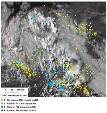
The summary of the contingency analysis is stored in the Ta-ble 1 and example visualisation of one case study
relation-The ost halle gi g jo as to tra sfor GI“ Allie
The proposed G‘ID− ased approa h of data a age e t allo s to study s
15.20h
Figure 4. Sum expression output map for ATS and RD rainfall estimations on the 4 June 2007, 15:20 h.
ship analisys between ATS and RD precipitation patterns is presented in Fig. 4.
The amount of analysed cases doesn’t seem to be enough to comment about the quality of satellite or radar derived rain rate products. However, it was noticed that spatial dis-tribution of precipitation within satellite and radar products fit much better to each other than to the automatic ground measurements. On the other hand, radar rain rate compos-ites seemed to overestimate pracipitation occurances, most probably because of non-precipitating cluter/anaprop echoes, which might have been neither recognised nor removed dur-ing NIMROD quality control procedure. Erroneous in situ ground measurements were also identified. Rainfalls were registered by the automatic rain gauge while there were no clouds visible in the corresponding satellite image.
6 Conclusion and further research
GIS gives possibility to perform very interesting compara-tive analysis of precipitation distribution by integration of data obtained from different sources (automatic rain gauges, satellite data, radar data). GIS methods are not only use-ful for studying simple case studies but also very efficient for advanced data analysis and visualization. GIS contains a wide range of tools to create complex maps of combined information. The most challenging task was to transform “GIS Allien” precipitation datasets into GIS rasters. Pre-sented scenrario of source data conversion made it possible
30 J. Walawender et al.: Qualitative analysis of precipiation distribution in Poland to view, manage, examine and visualize precipitation data
within ArcGIS environment.
The proposed GRID-based approach of data management allows to study spatial distribution of precipitation without ground data spatialisation. This approach seemed to be more convenient way of representing discrete in space parameters such as precipitation.
The chosen research method can be used for quality as-sessment of rain retrieval algorithms from different data sources and for various synoptic situations. The popular method of quality assessment of precipitation estimations de-rived from satellite and radar data by rain gauge measure-ments should be revised and adjusted. This research con-firmed that rain gauges have some own errors as well as radar and satellite technology.
More detailed research is planned to develop algorithm for qualitative analysis of rainfall distribution in Poland with use of combined precipitation information from different data sources and GIS. It is now clear that during detailed qual-itative analysis more attention should be given to in depth source data quality assessment and verification.
Acknowledgements. The work was partially financed by EU-METSAT H-SAF Project (Satellite Application Facility on Support to Operational Hydrology and Water Management) – 410/U/2005. ArcGIS 9.2 with Spatial Analyst used in this study is licensed to the Institute of Meteorology and Water Management, Satellite Remote Sensing Centre and was purchased in the frame of the Ministry of Scientific Research and Information Technology Grant number 618/E-217/SPB/COST/KN/DWM 50/2006-2007.
Edited by: M. Dolinar
Reviewed by: M. Percec-Tadic and B. Tellez Jurado
References
Atmospheric Data Modeling Group: Cataloguing data by usabil-ity in GIS, Atmospheric Front, ESRI, http://www.weather.gov/ regsci/gis/presentations/ESRI Fall06.pdf, last access: 22 Octo-ber 2007.
GRIB API online manual: http://www.ecmwf.int/products/data/ software/grib api.html, last access: 11 July 2007.
H-SAF Algorithm Theoretical Definition Document: Baseline ver-sion (ATDD-1.0), Part-2 – Algorithms for precipitation products generation, edited by: Bizzarri, B., 2007.
Stone, D. and Harison, D.: Nimrod System Documentation Paper no.2 – NIMROD Format for Image and Model field files, 2004. Szturc, J. and Dziewit, Z.: COST 717 Final Report, chapter: Status
and perspectives on using radar data, Poland, 217–220, http:// www.smhi.se/cost717/doc/WDF MC 200505 1.pdf, 2005. Szturc, J., Osr´odka, K., and Jurczyk, A.: 2006 Scheme of quality
index for radar-derived estimated and nowcasted precipitation, Proceedings of ERAD, http://www.grahi.upc.es/ERAD2006/ proceedingsMask/00162.pdf, 2006.