BUILDING THE URBAN RIVER EDGE:
Proposed Connections To The Water At The Foot of Boston's Beacon Hill by
Daniel Gorini
B.F.A, Rhode Island School Of Design Providence, R.I.
June 1981
SUBMITTED TO THE DEPARTMENT OF ARCHITECTURE
IN PARTIAL FULFILLMENT OF THE REQUIREMENTS FOR THE DEGREE MASTER OF ARCHITECTURE
AT THE
MASSACHUSETTS INSTITUTE OF TECHNOLOGY MAY 1994
Daniel Gorini 1994. All rights reserved
The author hereby grants to M.I.T. permission to reproduce and to distribute publicly paper and electronic copies of this thesis document in whole or in part.
Signature of the author -- ~~~~~~~~
Daniel Gorini, Department of Architecture May 6, 1994
Certified by
-Maurice K. Smith Professor of Architecture, Emeritus Senior Lecturer
Thesis Supervisor
Accepted by
A e dkosemary Grimshaw Chair person, Departmental Committee on Graduate Students
Rc tch
,I;AS A iI Sc; 1
JUL 141994
BUILDING THE URBAN RIVER EDGE; Proposed Connections To The Water At The Foot Of Boston's Beacon Hill. by
Daniel Gorini
Submitted to the Department of Architecture on May 6, 1994 in partial fulfillment of the requirements for the Degree of
Master of Architecture
Abstract
The core of this investigation is based on the design of built form at the public urban river edge. It proposes the transforma-tion of a portransforma-tion of public park edge into public built edge.
The Esplanade embankment at the foot of Boston's Beacon Hill forms the site for this thesis. The project area runs from the Longfellow Bridge at Charles Circle to the Arthur Fiedler Foot-bridge near the Hatch Shell. The thesis investigates built provi-sions for public inhabitation of the water's edge. At the size of the full project area the work explores built connections between the city and use of the river. At the building size design exploration focuses on extended public pavilion forms at the water's edge for a variety of uses.
Through design, analysis and critical assessment this investi-gation seeks to test the following hypotheses:
* 1) The urban water-edge should provide direct built
con-nection between the city fabric and use of the water.
* 2) Through provision for collective everyday use and
in-habitation of the water-edge certain areas of the river bank should act as social condensers.
e 3) Built definitions of physical form along the river can manifest an urbanism that celebrates density and diversity -of use and of population- as necessary positive attributes of contem-porary civil life.
The above mentioned project area is well suited for testing these hypotheses. The street pattern of the neighborhood is ori-ented toward the river yet it has been cut off from the water by Storrow Drive. Charles St. at the base of the hill has long pro-vided a strong core of public use. In addition this is an area in which some variety of use is already made of the river bank despite the physical barrier of the roadway.
It is important to note that this thesis is an exploration of built form at the urban water's edge and not a comprehensive city planning effort. Its core thrust is directed at architecture: that is, at the organization of habitable physical definitions and their spatial and experiential implications.
Thesis Supervisor: Maurice K Smith
Luigi Gorini, 1903 -1976. Dedication
This thesis is dedicated to the memory of my father, Luigi Gorini, and to his father Costantino Gorini. Both were research-ers in microbiology. The elder Gorini was director of the Labora-tory of Bacteriology at the School of Agriculture at Milano, Italy. My father, Luigi, received his doctorate in chemistry at the Uni-versity of Pavia in 1925. He conducted research in microbial genetics in Italy, France, and eventually the U.S. where he was Professor at the Harvard University Medical School. In 1974 he
Costantino Gorini, 1865 -1950
became Professor Emeritus, Department of microbiology and Molecular Genetics at the Medical School. He died in 1976 at Boston's Beth Israel Hospital a few hundred meters from his lab. During the Fascist period in Italy prior to World War II both these men acted to resist the right wing. Costantino Gorini was among the small number of academics who refused to join the Fascist party. Luigi was at the time a young researcher. He too refused to sign the mandatory allegiance and was among a small group who left the University. In a 1970 talk given at
Montana State University he recalled the events:
"The first uproar was "No" unanimously - we will never do that. But then came second thoughts, the rationalization: "We scientists should not be involved in politics; we should not permit that others, worse than us, would take our responsibilities, etc., etc." At the end we were about one hundred "No's" out of about ten thousand university people." 1
He was to join the resistance where his nonviolence kept him from a fighting role. For more than a decade from 1932 till the fall of the Fascist government he was unable to obtain aca-demic employment. In 1955 he came to the U.S. and eventually to Harvard. His dedication to resistance was to continue till his death.
I will always remember Luigi for his lifelong commitment to
learning, discovery, and intellectual rigor. In addition I will al-ways be inspired by his lifelong commitment to social responsi-bility and political activism. I see this quality as a legacy of resistance against Fascism, autocracy, and centralization of power; no matter what flag they may operate under.
For me Luigi and Costantino represent at once the inspira-tion and the burden of history. I can only hope that I am capable of following in their footsteps.
Acknowledgments
I am deeply indebted to Maurice K Smith and to Fernando
Domeyko. These consummate teachers have given me the core of my education. Their knowledge of -and passion for- the
disci-pline of building is doubtless unmatched. I will be continually inspired by their dedication and unrelenting rigor. (Special thanks goes to MKS for his sense of humor).
Thanks to my first MIT instructor, Tom Chastain, for setting me straight.
Thanks to Akos Moravanszky for his invaluable guidance in history, theory, and criticism.
Thanks to my colleagues: Duncan Kincaid, James Carr, Tay-lor Galyean, and Darrell Aldrich for their criticism and support during this endeavor.
Special thanks to my mother Annamaria Torriani, Professor of Biology, Emeritus MIT Department of Biology, for her unwa-vering help and support.
Finally a special dedication to Marco, Nika, and especially to Laura for their love and patience.
"I will try to be the most unequivocal radical
possible and at the same time constructive." 2
1) Gorini, L., University and Ethics text of talk given on Feb. 10, 1970, at
Montana State University, Bozeman Montana. 2) Ibid.
CONTENTS
C H A P T E R 1 C ity Size: T h e C h arles R iv er Basin ... . . . ... ... .. . 11
1 .1 T h e c ity siz e ...- ...- -... -- --.----.. ... ... 13
1.2 Boston's urban fabric and the C harles River Basin ... 13
1.3 The urban river as use-form ... ... -... ... --14
1.4 Stu d ies at th e city size ... --... . ... ... 16
C H A P T E R 2 P roject A rea ... . . . . ... ... ...--... . ... 23
2.1 T he foot of B oston 's B eacon H ill ... -... --... ... ... 25
2.2 C onditions in the project area ... ... ... ...--... 27
2 .3 A n a ly sis ... --.... -... .. ... . ..--.. 3 4 2.4 D esign exp lo ratio n s ...---... -... -... ... ... 4 2 2.41 The embankment and the roadway ... ...-...-... 42
2.42 Social condenser: inhabitation of the project area ... ... .... 43
2.43 A ccess in the p roject area ... ... ... ... 44
2.5 Experim ents in higher density ... ----... ... ... ... ... 48
C hapter 3 B uilding at the U rban W ater's E d ge ... 51
3.1 Inhabitation of the built river edge ... ... ... ... 53
3.2 Built definition and use of the w ater ... ... ... ... 59
3.3 M aterials studies, building references ... -... ... ... 61
3.4 Building at the w ater's edge ... ... ... ... 74 3 .4 1 T h e site ... ... ... -... ... .. ... 7 4
8
3.42 The extended public pavilion ... 75
3.43 M aterials and context ... 78
3.44 Design and analysis...80
Chapter 4 A Brief Form History of the Charles River Basin... 105
4.1 The bridges ... 107
4.2 Shipping on the Charles ... 108
4.3 Railroads ... 110
4.4 The river banks: residential developm ent, m anufacturing ... 111
4 .5 T h e d a m ... 1 1 2 4.6 The park lined river edge and the autom obile ... 113
4.7 N eighborhood fabric and the river ... 115
C h a p te r 5 T h e P a s to r a l M e tro p o lis ... 1 1 7 5.1 Introduction ... 119
5.2 N ature and the natural...121
5.21 Am erican attitudes: the scenic experience...121
5.22 N ature conquered...122
5.23 The panoram a, the dioram a, nature and the love of ruins ... 123
5.3 Am erican reform ism ... 127
5.31 The fear of public...127
5.32 Aesthetic and m oral enrichm ent as key to social reform ... 129
5.33 Rejection of governm ent in favor of the self ... 133
9
5.4 A de-urbanization of the metropolis ... ... ...--...--...- 137
5.41 City nature: the urban fabric and the "natural" ...--... 137
5.42 Suburbanization and the segregation of use ... ...--...----...-..-... 138
5.43 Conclusion ... .... ...---...-...---... 141
C o nclu ding N o tes ... . . . ... ... ... ... 143
CITY SIZE: THE CHARLES RIVER BASIN CHAPTER 1
Overlexf: Fig. 3. The Charles River Basin, view Southwest from the Longfellow bridge. Photo: D. Gorini
1.1The city size.
The architectural design project, wether for building form or city form, must be considered and understood at a full range of sizes. It is therefore imperative that the urban project be ana-lyzed in its relationship to the life and form of the city. It is only through work of this type that the project can hope to be more than an autonomous gesture. In addition the project can thereby establish substantive connections to its context without resorting to historicisms or ersatz stylistic vocabularies. This analysis must occur at the largest experientially verifiable size. The no-tion of experiential verifiability is important; urban form analy-sis can easily deteriorate into graphic production when done in plan at the largest size. By seeking to maintain a constant con-nection to experience and use 'on the ground' explorations can become more directly relevant to design of built use-form.
In the case of the project area being considered here the largest experientially verifiable size is unusually extended. This is due simply to the fact that it is located on the Charles River Basin. Identifiable points along a river are by nature associa-tively and experientially connected to other areas along the same river, even if they are well out of sight. In addition the Basin adjacent to the project area is quite large. The reach be-tween the Harvard bridge and the Longfellow bridge measures approximately one mile in length by nearly a half mile across.
The following series of analyses were done primarily to ex-amine two factors in the Basin's relationship to the surrounding
city: They are:
* 1) The built connections -or lack thereof- between the city fabric and use of the water.
* 2) The effect of the roadways which circumscribe the Basin
on the form and use of the river.
This document includes a written form history of the Basin that supports the graphic analyses found here. The reader is
asked to turn to the chapter of that name for further reference. 1.2 Boston's urban fabric and the Charles River Basin.
The Charles River Lower Basin is a central component of Boston's urban form. It constitutes a basic amenity and an iden-tifying image for the city. However, the vitality of an urban or architectural form can only be validated through use. To that end the re-connection or re-urbanization which I propose is based simply on the notion of inhabitation of the Basin and the river. The Basin can only reach its potential as an expression of civitas by being lived in. If the Basin is to be more than an icon it must be re -appropriated for use. It is too precious to remain simply a vision of romantic landscape.
Despite the obvious success and importance of the continu-ous park system along its banks the Basin is for the most part disconnected from the city. Not a single neighborhood exists around it in which the built fabric makes physical connection to the water. The roadways which completely circumscribe the Ba-sin have established daunting barriers between the city and the river. The pedestrian does not arrive at the water's edge in the normal course of movement through the city. In addition, uses considered typical of urban rivers are not found in the Basin. As
a result the Basin has been reduced to an icon; a representative symbol for the city. With the exception of recreational boating and the annual armada of independence day revelers the Lower Charles remains little more than a scenic amenity.
The role played by Olmsted's parks vision is discussed in an essay on the 'Pastoral Metropolis' found at the end of this docu-ment. Therein I contend that prevailing theory at the time of the basin's last construction called for simulations of ex-urban or faux-natural environments in the city. These simulations consti-tuted part of a program to render the emerging metropolis in a pastoral palette; that is, to provide areas of spatial de-urbaniza-tion in the growing city. As played out on the Lower Charles these theoretical positions, though commendable in their intent, contributed to the disassociation of the river from its city. 1.3 The urban river as a use-form: a relationship between the urban landscape and the river.
The urban river exists as a built form. It is not, nor should it be, a function of purely "natural" hydrological and geophysical forces. It must be understood as an urban form element. It is therefore invariably a product of the spatial conceptions and attitudes which prevail when interventions are made on its form. Seen in this manner the river can be understood as being among the largest and most significant of city forms. The urban river is at once a spatial and temporal instrument of cultural locating. Such locating can achieve some level of authenticity only if it is manifest through collective use.
Clearly the urban river edge must be an absolutely public
zone. Given this assumption the river bank may exhibit two basic classes of form. It may be an urban built edge or an urban park edge. The Charles River Basin is circumscribed by an un-broken park edge. This green edge is invaluable. The water pro-vides a guarantee of an open flank. The citizen can therefore find a true spatial alternative to the city fabric. In this condition the river bank acts as an unmatched diffuser for the urban popu-lation. Nonetheless this thesis is based on the conviction that river cities need areas of built public water edge. These areas should act in contrast to the park edge; they should act as social condensers. Areas of built edge should provide free access to varied public use of the bank and the water.
The Charles is certainly a physical and cultural locator (as are most urban rivers). To a great extent however the Charles has ceased to be an access and use form. Traditionally rivers have been vital routes for intra-urban transportation. In the past this has unfortunately included the transportation of waste ma-terials in the water itself. In addition heavy use of the waterway
by motorized craft is known to make sailing and rowing
diffi-cult. Now however the use of urban rivers for public transporta-tion can in fact contribute to the improvement of urban ecolo-gies. The use of low-wash hull designs can allow for efficient water taxi service without disturbing recreational boating, par-ticularly on bodies of water as large as the Lower Basin. Water taxi service could easily decrease Boston's dependence on Storrow Drive. Provision for parking at Allston Landing could allow commuters from the West on the Mass Pike as well as those on Storrow Drive to use water transport into downtown.
Such a link could easily connect to the existing water transport services in Boston Harbor and along the South Shore. These water taxis already provide commuters from the south and trav-ellers bound for Logan Airport with alternatives to the motor vehicle.
The current condition of Boston's river is one of continuous physical barrier between the city and the water. At all points the public must cross roadways or negotiate minimal overpasses to reach the river banks. If the Charles is to become a more active public waterway key areas along the banks must be built to provide transition between the urban fabric and use of the water. In these areas building form must be present to define physical connections to the city. Building form can provide the shelter and containments necessary for the full range of public uses.
The river bank at the foot of Beacon Hill can become one of these areas. This stretch of water should be reconnected to civil life of Charles Street. Despite the pedestrian overpasses which currently provide minimal access this zone is varied in its use. The Hatch Shell is a popular venue for public entertainment during the summer months. The city boat house provides public sailing facilities. The Charles Circle MBTA stop offers ready public transportation access to the area. At the Southern end of the area the grain of the city fabric and the curve of the river embankment establish a direct link to the Public Gardens.
Fig. 4. View across Storrow Drive under the Arthur Fiedler Foot-bridge. Photo;
Studies at the city size
'I _
J
- ('~,. ~L
Fig. 5. The Charles River Basin.
Beacon Hill and the project area are shown here in their relationship to the Charles River basin. The Beacon Hill neigh-borhood can be seen as the cornerstone of the lower Basin. In
Fig. 6. An early study of potential sites along the Basin
Having established the intention to explore built public con-nections to the water the Basin has to be examined at the full city size in order to choose possible sites for intervention. Seven areas are chosen as viable locations. These are:
e1) The South bank opposite Governor's Island. A difficult site in the shadow of elevated roadway structures.
e2) Open land at the Cambridge springing of the Boston University Bridge.
o3) Charlesgate. An area where roadway structures have
had a particularly deleterious effect on Olmsted's park.
e4) The sea wall along the M.I.T. campus where existing boat houses establish minimal built definition of the edge.
e5) The Esplanade along Back Bay. e6) The foot of Beacon Hill
e7) The no-man's land between the older and the newer Charles River dams.
Fig. 7. A study of the neighborhoods which surround the Basin.
A number of distinct neighborhoods are found near the lower Charles River Basin. Some of these were in the past more directly connected to use of the water. Now they are without exception separated from the River by the roadways which cir-cumscribe it.The figure above shows the grain and orientation of these areas as well as the barriers which run between them and the water.
1) Allston
2) The Northern corner of Brookline
3) Cambridgeport
4) East Cambridge
5) Back Bay 6) Beacon Hill
7) Charlestown
8) Site of the former West End destroyed by developers and overzealous
Fig. 8. Institutions and Business land along the lower Basin.
The river edge is largely occupied by businesses and institu-tions. However these are also cut off from the water by the ever present roadways. In some areas -Cambridgeport for example-a strip of institutionexample-al or business lexample-and forms example-a bexample-arrier zone in addition to the road. This acts to further insulate the neighbor-hood from the water.
1) Harvard Uiversity
2) Boston University
3) The Massachusetts Institute of Technology
4) Business and manufacturing land 5) Hospital campus
This figure examines the land area near the Basin that has been taken for roadway infrastructure. At Charlesgate and at Charles Circle elevated interchanges have served to choke off key points of connection to the water.
1) Allston Landing. The major interchange for highway connection to the West.
This is the point of arrival for 1-90 known as the Mass. Pike. 2) Charlesgate. This roadway is the Storrow Memorial Drive.
3) The Mass Pike Extension. Here the road travels in a wide trench cut through
and under the city.
4) Charles Circle. Interchange between Storrow Drive and the Longfellow Bridge.
5) Leverett Circle and the infamous connection to 1-95 and 1-93. Interchange to points North, South, and East.
Fig. 10. Public transportation near the Basin
The solid lines in the figure above indicate subway and light rail lines. The dashed lines are bus routes. Note that there are no transportation routes on or along the river. This is directly re-lated to the lack of use connections between the river and the city. In the proposal being presented in this thesis areas of built public river edge would spawn water taxi service to connect them.
Parking could be provided at Allston landing for travellers on 1-90 -see figure, facing page-. Water taxi service could then
offer an alternative to the car for the last leg of a commute into downtown. Water taxi service has for a number of years pro-vided such an alternative to residents of the South Shore.
Fig. 11. Area of river and wetland filled for building since the 17th century.
This image affords an idea of the extent to which the topog-raphy of the area was altered in arriving at the current form of the Basin. All of the shaded area was tidal wetland or river. All of it had to be filled in order to build on it. The current form of the Basin is shown darkest.
Overleaf: Fig. 12. The project area viewed from the Longfellow Bridge. Photo
25
2.1 The Foot of Boston's Beacon Hill
In considering design interventions on the river bank at the foot of Beacon hill two primary form issues emerge as salient. The first is the problem of Storrow Drive. The second is the lack of built definition for shelter and inhabitation on the embank-ment beyond the roadway.
The first issue is simply a case of physical barrier. The Drive is built on embankment land originally intended as green space directly connected to the city. This is a condition which has un-fortunately become common to many river cities worldwide. The river banks are often the most easily appropriated linear zones on which to build express roadways. (These roadway projects appear to be public works and are paid for with public funds. Yet the results eliminate urban territory from public ac-cess and use. The automobile -as it is currently used- constitutes a maximum privatization of transport). The design problem in this project is one of building connections to the city across the barrier of the roadway. These connections must be territorial and not simply provisional crossings as are the existing pedes-trian overpasses. Direct and easy access must connect public use in the city to public use at the water's edge.
The second of the aforementioned form issues is a question of use. Under current conditions the project area offers only minimal built provisions for inhabitation of the bank. There are no structures which might house uses to bring the public to the water edge in the course of daily urban activity. Similarly the
in disrepair. More significantly there is little incentive for boat-ers travelling on the Basin to dock. This project proposes an area of built public edge on the bank and on islands splitting off into the Basin. A variety of uses are envisioned including a theater complex with outdoor stage. Restaurants and bars, retail space and provision for markets could also occupy the area. The exist-ing recreational boat houses would of course be provided for.
A built area of this type, connected to the city, could become active both from the land and the water. Public and private water taxi services would have ample reason to establish taxi stops or even to base operations from such a facility. Municipal services such as police and park maintenance could have auxil-iary offices with launch slips allowing for ready water-born ac-cess to the Basin. Boaters from the harbor and from up river as far as Watertown would find public docking facilities for small craft. It would therefore be possible to travel by boat from Charlestown, for example, and find public attractions directly accessible from the water. Likewise it might be possible to travel
by water taxi from Allston to a public concert and back. The
Galleria Mall retail complex at the Northeast corner of the Basin currently makes use of the former Lechmere Canal to connect to the Charles. The mall itself exhibits a typical architecture of gar-rison exclusion while the canal is nothing more than a quaint cul de sac. Nonetheless some effort has been made to connect with the Basin. The proposal being presented here would establish another connection to the larger city. It does not require a stretch of the imagination to envision a water shuttle connection
be-tween these points as well as to others which might be estab- Fig. 14. Detail of project area from a 1902 map showing conditions befor the first embankment. Source: MDC archives.
lished along the river.
2.2 Conditions in the project area
Beacon Hill slopes rather steeply West from the Massachu-setts State House toward the Charles River. The hill flattens at Charles Street which runs parallel to the river bank and cuts across the directional grain of the neighborhood. Charles Street has long been the primary public and commercial axis of the neighborhood. At the foot of the hill the neighborhood contin-ues toward the river on land that is practically flat. Prior to the first embankment the urban fabric ran directly to the water, see Fig.14. That edge is currently defined by Storrow Drive.
Longfellow Bridge, MDC Sailing PavilionStorrow Drive Esplanade Embankment -Hatch Shell -Fiedler Footbridge
Fig.15. Right. Esplanade Embankment at Beacon Hill. Source: BRA survey map. The project area runs North -South for aproximately 1800 ft. from the Longfellow Bridge to the Arthur Fiedler Foot Bridge where the river bank turns West
Fig. 16. Above. View North along Storrow Drive from the Arthur Fiedler Footbridge.
29
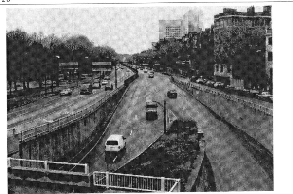
Fig. 18. Above. View South along Storrow Drive from the footbridge at the North end of the project area connecting Charles Circle to the embankment . Fig. 19. Right. Sight lines for above photo
Fig. 20 Above. Under the footbridge looking toward Charles Circle. Note that there is no access to the embankment between this overpass and the Fiedler foot bridge aproximately 1800 ft. to the South.
Fig.21. Above.
Top: Sight lines for photo at left.
Mid: Sight lines for photo facing page at left. Btm: Location of photo facing page at right.
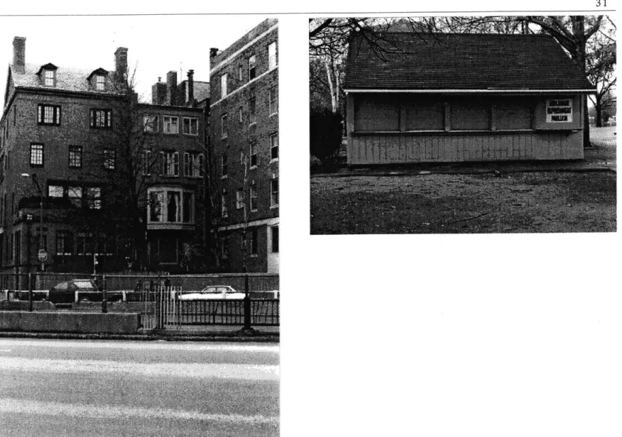
Fig. 22. View East across Storrow Drive. Prior to the embankments these build-ings backed directly against the water .
Fig. 23, Above. The rather pathetic "Esplanade Refreshment Pavilion" is the only eating or drinking establishment on the river side of the Drive
Fig. 24. The central steps leading to the water at the existing boat haven. The view is south from a small dock. Photo D. Gorini
Fig. 25, Left Approximate sight lines for photos facing page and above. Fig. 26, Above: View of boat haven steps looking south. The fact that the steps are in disrepair is secondary to the fact that they are not backed by use connec-tions to the city. There is little incentive for boaters travelling on the Basin to dock here. Docking facilities are minimal. There are no built definitions at the water's edge that might house restaurants, stores, indoor public entertainment and the like. Photo, D, Gorini
C C
-K'
* - \' ~
~ A~ ~
4,
~ ~Fig. 27. Beacon Hill and the StorrowMemorial embankment. Source: BRA Survey map.
Analysis in the project area
The following series of studies were conducted in order to establish a basis for design work. They are intended to clarify the grain and dimension of the Beacon Hill city fabric as it is experienced by walking the neighborhood. The hill exhibits an undeniable orientation toward the river. It is among the most
clearly defined neighborhoods in Boston proper. This is in part due to the fact that most of its streets do not pass clear through the area. Charles Street is the only major axis that cuts through the neighborhood. It provides a public core for the area yet it does not act as an edge. Beacon Hill without question runs down to the river.
-)
-U
Fig. 28. A study of certain dimensions which can be found to recur and which
can be apprehended when walking through the project area. 900 ft600 ft 350 ft
kqI
I M.
Fig. 29. The streets running down the slope of Beacon Hill.
The Beacon Hill neighborhood is distinctly directional. Streets running up and down the hill are longer then those run-ning across the slope. Sighting down these longer streets often offers a tightly framed view of the river.
1V
Fig. 30. Cross streets on Beacon Hill. Charles St. - center, ending at Charles Circle - is shown darker, as is Storrow Drive - at left. The streets which run across the primary grain of Beacon
Hill are generally shorter than those which run with the slope. The hill is ridge backed. At its crest near the State House -at right, above- secondary slopes run North to Cambridge St. and South to Beacon St. Due to this the two streets which cross through the East end of the neighborhood are not experienced
as through streets. In addition these streets -Joy St. and Bowdoin St.- are not through streets at the larger city size. Charles St. is the exception and its public character and use reflect this. However the grain of the neighborhood easily crosses Charles St. The ac-tual physical edge at the base of the hill is formed by Storrow Drive.
This early design iteration proposed a series of piers and islands. Extending finger-like into the Basin these were seen as continuations of the directional grain of the Beacon Hill city fabric. However the primary effect of piers such as these is to intensify and extend a single land edge while blocking the larger direction of the river edge. For both of these reasons this pro-posal was rejected.
MVy~
Fig. 32. Study of directional island forms.
This iteration ultimately became the basis for the project. This form type offers a number of advantages over the piers which had been considered earlier. In contrast to the piers direc-tional islands such as these multiply the water edge rather than extending a single edge. This is important to the project since a central intention of the work is to propose varied conditions of
I ~**. ~?~'
built water edge. In addition water traffic remains free and open through the project area. While piers tend to be private forms these multiplications of the river bank are essentially public. Note the remaining finger along the Longfellow Bridge at the Northern edge of the site. This too was eventually eliminated from the plan.
40 J~
~*
I
I - -- - -. r "Elevated rail -- - Subway tunnelFig. 33. Study of existing and proposed use zones in the project area.Burot Existing public/retail zone
41
Fig 34. The project at the city size. The relationship of the proposed direc-tional islands to the Basin and to the Beacon Hill fabric is illustrated at this scale. The existing Esplanade island is shown in lighter grey, the project as proposed is indicated by the darker tone. It is important to note the extent of the intended transformation from public park edge to public built edge. This transformation would occur in the circled area at the foot of Beacon Hill. Other selected areas along the river could be transformed in this manner without compromising the value and access continuity of the existing park system.
2.4 Design explorations for the project area.
Fig. 35. An early sketch of design intentions at the project area size.
The primary design objectives in this aspect of the project are twofold: 1) There is the question of transforming the em-bankment and the roadway in order to establish the intended connections to the city, 2) Proposals must be made for inhabita-tion of the transformed river bank; there must be proposed built definitions for use.
2.41 The embankment and the roadway
The core actions in addressing the first objective are as fol-lows. The existing embankment is cut back to the edge of Storrow Drive. Directional islands and fingers of fill oriented along the river bank are proposed to establish the primary form condition of the project. By bringing the water to the edge of the Drive the true base line of Beacon Hill is in part defined by the water edge. The Drive itself is proposed as a sunken roadway carried in open topped concrete boat-sections. This roadway is then variably covered and the territory thus defined is inhab-ited. It is intended that the existence and life of the road below should maintain some associative connection with the world above. Likewise the roadway as an historical and physical fact of the city is to be acknowledged in the form.
Two bands of fill form the proposed land in the Basin be-yond the roadway. In the final equation the project proposes a net gain in land surface. At the same time the single existing water edge is multiplied fivefold.
2.42 Social condenser: inhabitation of the project area.
Fig. 36. Model at 1/50" = 1'. Existing condition of roadway and
embank-ment.
Fig. 37. Model at 1/50" = 1'. Initial design assumption. -- --- I
---Fig. 38. Model at 1/50" = 1'. Embankment proposal.
important intent is that the form be public and collective. That is, built definitions for inhabitation should serve the stated goal of establishing a social condenser at the Basin. The proposed building form should suggest uses which bring people together at the water edge. This should occur in the course of daily urban life and not only on certain occasions as it does now.
With respect to this question the proposed primary form is a multiplication of the use condition found at Charles St. That is, the public zone of Charles St. would be repeated with decreas-ing density along the proposed water edges. Significantly the direction of Charles St. -parallel to the major direction of the water- would be repeated. Retail or commercial uses are not proposed perpendicular to this direction. A theater complex would be found on the first band of fill. This would include an outdoor stage to replace the existing Hatch Concert Shell. The existing recreational boating facilities would be housed on the outer band of fill. Urban ground surfacing such as brick would predominate closer to the city while some greensward would reappear on the outer island. Trees inland would be planted singly or in small groups in order to help define open territory in built areas. On the outer island more extensive groups of trees would provide shade and form definition in larger areas of green space.
2.43 Access in the project area.
Beacon Hill is bounded on the North by Cambridge St. and on the South by Beacon St. These constitute the major access to the city at the larger size. Between these there are four smaller
residential streets which lead down to the project area from Charles St. The proposal identifies three main points of entry to the area and seeks to define them physically: 1) At the Northern end is the MBTA stop at Charles Circle. 2) Near the middle of the area is Pinkney St. Here an existing mid-20th century apart-ment complex would be replaced by a linear finger of park con-necting the project to Charles St. 3) At the Southern end a spur of the existing Embankment Rd. leads toward the Public Gar-den. The proposal calls for building a partially covered market area over the sunken roadway to define this entrance. This would face the existing -and proposed- viewing/seating area for outdoor concerts. It could provide shelter for regular temporary market activity as well as for concert concession sales.
Limited vehicular access to the outer island is provided by a viaduct at Revere St. Rather than an isolated bridge this struc-ture is embedded in a higher density of building and uses. Con-tinuity of pedestrian access is aimed for, particularly in the pri-mary direction along the river. This is achieved through a com-bination of ground level and elevated access. From the water the proposal calls for open access for small craft and water taxis. The form of the islands allows boat traffic to move into the built fabric while still travelling through in the direction of the water. Numerous areas of public docking facilities are envisioned. It
Fig. 39. Model at 1/50" = 1'. Addition of directional islands.
Fig. 40. Model at 1/50" = 1'. Early pass at the full area. Note the finger along the bridge at top. At middle are some preliminary building form proposals.
Fig. 41. Model at 1" = 25'. Detail of proposed variable covering over Storrow Drive. This view shows the area at the foot of Pinkney St.
47
Elevated MBTA station at Charles Circle
Revere St.
Pinkney St.
Proposed theater complex
Embankment Rd. entrance leading to Beacon St. and the Public Gardens. Note proposed coverings for markets or con-cert concessions.
Fig. 42. Model at 1/50" = 1'. Note the removal of the finger along the Longfellow Bridge. This allows the form to provide smoother access continuity for water traffic.
Fig. 43. Model at 1/50" = 1': An interation of the experiment in density above four stories. The view is from the North with the Longfellow Bridge at bottom. In this case the intervensions are at some distance form the existing city edge. .
2.5 Experiments in higher density
The scale of intervention at the project area size demands some exploration of housing built to the water at relatively high density. The reader must understand that the author views such proposals with great skepticism. Yet it seems clear that a pro-posal of this nature must at least be considered. Built urban river edges have always been partly occupied by housing. How-ever, the social and economic conditions which govern the Basin severely limit the possibilities. The Basin edge is among the most precious territory in the city. Lower density housing within four or five floors of the ground would immediately be-come the province of developers. This is therefore rejected out of hand. In addition such intervention would invariably be del-eterious to the intended public form of the project. Low-rise development of this sort would constitute an incursion of the neighborhood housing fabric into public territory that has al-ready been claimed. Despite my differences with the Parks Movement the claiming of urban territory for permanent public use is an unassailable accomplishment of that period. Erosion of such public territory is anathema to the convictions which drive this thesis. The transformations proposed in this document are intended to be absolutely public. Physical definitions of privacy at the ground can not be supported. If they are built in the direction of the river edge they will block associative access from the city to the water. (Physical access can always be pro-vided in selected zones as in any street pattern). If they are built perpendicular to the water edge they threaten to block free pub-lic access along the bank. Neither of these form scenarios is
ac-ceptable. In addition such housing stock would be of such high value that it would become absolutely private and inevitably the domain of the rich.
Given these understandings the sole remaining possibility is to build up. Such interventions can only occur in two possible forms. We can build vertically in towers or we can build up horizontally by raising buildings on piers. The former is an ac-tion of absolute privacy and hierarchy. The latter becomes, by process of elimination, the only possible scenario. If this is the case then certainly the form of such interventions must achieve three objectives: 1) They must be built perpendicular to the river bank so as not to attenuate visual access from the city to the water. 2) They must be high enough above the public ground to allow full light and physical access along the river bank. 3) They must rise from ground level public structures; that is, entry to such structures must be from clear definitions of public territory and public use. These criteria are exceedingly difficult to fulfill outside of utopian fantasy. Nonetheless the proposals illustrated here are an attempt to address these issues.
Fig. 44. Model at 1/50" 1'. In this case higher density is built directly over the covered roadway along the existing city edge.
50
I;
Fig. 45. Study of the project area.
Overleaf: Fig. 46. An extended dock of the MDC public sailing facility at the foot of Beacon Hill. Photo: D Gorini
Inhabitation of the built river edge.
Fig. 47. Collective inhabitation of the built water edge. A ghat on the Ganges at Benares. Source: Coute, P, and Leger, J,. Benares, An Architectural Voyage, Edi-tions Ceraphis, Paris 1989.
Fig.48. Benares; the city builds steeply down to the water.
Source: Coute, P, and Leger, J,. Benares, An Architectural Voyage, Editions Ceraphis, Paris 1989.
Fig. 49. Chat on the Ganges at Benares. The built river edge exhibits a rich variety of public form conditions .Source: Coute, P, and Leger, J,. Benares. An Architectural Voyage, Editions Ceraphis, Paris 1989.
Fig. 50. Ancien Hotel -Dieu, La Seine, Paris. Fig. 51. Venice: An urban environment of built water edge. Photo D. Gorini Source: Les Berges de La Seine J.M. Leri, Consevateur, Biblioteque Historiqe de